|
|
Order by: Available to: This site contains affiliate links for which I may be compensated
|
Buy It Now
Free Shipping Location: Olympia, United States Explore the land of the Bible with this vintage map of the Holy Land from 1963. Featuring crisp detail and abundant historical notes, this map includes ... morean inset map of the Middle East showing Crusade routes and a detailed map of the Walled City of Jerusalem with fourteen stations marking the way of the cross from Pilate's hall to Calvary. This map is in good vintage condition, with some signs of wear and tear consistent with its age. The first photo shows a stock image of the whole map, while the second and third photos show the actual folded map for sale. Shipping is free, so don't hesitate to add this beautiful piece of cartography to your collection!
Buy It Now
$3.50 Shipping Location: Winter Springs, United States Beautiful, rare, important, antique 1805 copperplate Arrowsmith & Lewis map, titled Egypt, printed at bottom is From D'Annville, and Published by Thomas ... moreAndrews. The map is printed thick fine period handmade paper, with no printing on reverse.
Buy It Now
$19.00 Shipping Location: Egypt Map of the Arab Republic of Egypt drawing scale 1: 1000000 1981. Title: خريطة جمهورية مصر العربية مقياس الرسم 1: 1000000 1981. Publication Year: 1981. ... moreWeight: 90 Gram / 0.2 lbs. Number of Pages: 2 Pages.
Buy It Now
$6.95 Shipping Location: Dover, United States Issued 1865 Gotha by Justus Perthes for Sprunner. Very detailed 19th century engraved map with original outline hand color. Original center fold as issued.
Buy It Now
Free Shipping Location: Monroeville, United States Date - 1869. inventory# j71296.
Buy It Now
$19.00 Shipping Location: Egypt Country/Region of Manufacture: EGYPT. Title: أطلس الصور الفضائية لسيناء من القمر الصناعي الأمريكي لاندسان 1980. Publication Year: 1980. Remote Sensing ... moreCenter, Academy of Scientific Research and Technology.
Buy It Now
$15.00 Shipping Location: Cyprus Map maker: Felix Delamarche a French geographer. Origin: Atlas de la Geographie Ancienne, du moyen age, et modern. Condition: Nice copperplate engraved ... moremap with old hand coloring in very good condition.
Buy It Now
$19.00 Shipping Location: Egypt Map of Qena, Egypt 1:500.000 1946. Title: خريطة قنا مصر 1:500000 1946. Author: THE SURVEY OF EGYPT. Publication Year: 1946. Publisher: THE SURVEY OF EGYPT. ... moreCountry/Region of Manufacture: EGYPT. Map - خريطة.
Buy It Now
$19.00 Shipping Location: Egypt Country/Region of Manufacture: Egypt. Publication Year: 1980. Map - خريطة. Cutting on.. Crease.. : A simple cut in the cover and pages, with a slight ... morefold in the pages that does not affect the content.
Buy It Now
$8.00 Shipping Location: Moab, United States This hand-drawn map is one such example. The town of Rockerville, South Dakota was founded in 1877 after placer gold was discovered. Soon a small boom ... moretown would arise. Because placer gold required large quantities of water, production was limited.
Buy It Now
$6.22 Shipping Location: WALSALL, United Kingdom This antique map showcases the Middle East, including Jerusalem, and dates back to around 1840. With intricate details and vibrant colors, this map is ... moresure to be a conversation starter and a valuable addition to any collection.
Buy It Now
$7.75 Shipping Location: Boonville, United States Kalkaska County was organized in its own right on January 27, 1871. As of the 2020 census, its population was 17,939. [2] The county seat is Kalkaska. ... moreKalkaska County has over 80 lakes and 275 miles (443 km) of streams and rivers.
Buy It Now
$11.84 Shipping Location: ILKLEY, United Kingdom Date: 1739.
Buy It Now
$9.97 Shipping Condition: Unspecified Location: LONDON, United Kingdom The image below shows an enlarged cross section from the centre of the map to show the level of printed detail DATE PRINTED: 1953. AUTHENTICITY: This ... moreis an authentic historic print, published at the date stated above.
Buy It Now
$19.00 Shipping Location: Egypt Map of Kalabsha Egypt 1:100,000 Survey Authority 1943. Country/Region of Manufacture: EGYPT. Number of Pages: 1 Pages. Publication Year: 1943. قطع بسيط ... moreبالغلاف مع ثنى بسيط لا يؤثر على المحتوى. هل يوجد قطع؟: قطع بالغلاف.
Buy It Now
$19.00 Shipping Location: Egypt Title: الأطلس التاريخي و به خمس و سبعون خريطة و رسما بالألوان لايضاح أهم المواطن التاريخية و التغيرات الإقليمية في العصور القديمة و المتوسطة و الحديثة ... moreمحمد رفعت بك 1926. Publication Year: 1926. Topic: Historical تاريخ.
Buy It Now
$25.00 Shipping Location: Belvedere Tiburon, United States Faisal’s son, Abdul Rahman bin Faisal, asked Palgrave to get him strychnine. Palgrave believed that Abdul wanted it to poison his father. Palgrave was ... moreaccused of espionage and was almost executed for his Christian beliefs.
Buy It Now
$3.00 Shipping Location: Winter Springs, United States Superb, fine antique 1856 handcolored map, titled Egypt, very detailed fascianting period map. This is a Gaston and Morse map. Morse was a highly regarded ... moremapmaker of this period. Many fascianting areas.
Buy It Now
$6.95 Shipping Location: Dover, United States Issued 1842, Paris by Lapie. Engraved by Tardieu. Finely engraved large oversize early 19th century map with original outline hand color. French text. ... moreNice looking map suitable for display. Original center fold as issued.
Buy It Now
$19.00 Shipping Location: Egypt The Arab Atlas of the Egyptian Ministry of Education, THIRD Edition 1984. Language: Arabic. Title: الأطلس العربي وزارة التربية و التعليم المصرى الإصدار ... moreالثالث 1984. Publication Year: 1984. Cover: Paperback.
Buy It Now
$4.95 Shipping Location: Dover, United States Issued 1895, Gotha by Justus Perthes for Stieler. (Africa, North Africa, Middle East, Ottoman Empire, Arabia, Holy Land, Egypt, Red Sea, Lower Egypt, ... moreSuez Canal, Alexandria, Cairo). Very detailed 19th century engraved map with original outline hand color.
Buy It Now
$19.00 Shipping Location: Egypt New Atlas Kuwait and the World 1975. Language: Arabic. Title: الأطلس الجديد الكويت و العالم 1975. Publication Year: 1975. Cover: Paperback. Number of ... morePages: 125 Pages. Country/Region of Manufacture: LEBANON.
Buy It Now
$30.00 Shipping Location: Egypt
Buy It Now
$4.95 Shipping Location: Dover, United States Issued c. 1859, Paris by Delamarche. Uncommon mid 19th century engraved map with original hand color. Original center fold as issued. Monde Connu Des ... moreAnciens.
Buy It Now
$6.23 Shipping Location: DERBY, United Kingdom SUEZ BAY, EGYPT. ORIGINAL ANTIQUE SEA CHART. THIS ENGRAVING / PRINT IS OVER 110 YEARS OLD, AND. NOTA MODERN COPY. IMAGE SIZE 7.25 X 5.5 ins 18.415 X 13.97 ... morecms.
Buy It Now
$3.50 Shipping Location: Winter Springs, United States Beautiful, rare, important, antique 1805 copperplate Arrowsmith & Lewis map, titled Asia Minor, printed at bottom is From Various Authorities, and Published ... moreby Thomas & Andrews. The map is printed thick fine period handmade paper, with no printing on reverse.
Buy It Now
$5.25 Shipping Location: Oklahoma City, United States This map is sure to be a conversation starter, with its vibrant colors, intricate illustrations, and unique style.
Buy It Now
$3.50 Shipping Location: Winter Springs, United States Beautiful, rare, important, antique 1805 copperplate Arrowsmith & Lewis map, titled Persia, printed at bottom is From Arrowsmith's Map of Persia. The ... moremap is printed thick fine period handmade paper, with no printing on reverse.
Buy It Now
$3.65 Shipping Location: Portland, United States Excellent condition National Geographic map 1972 the Middle East and their cultures. No rips. Tears or stains Posted with eBay Mobile Posted with
Buy It Now
$15.00 Shipping Location: Brooklyn, United States The map depicts the region from southern Italy to the Indus River and from the Black Sea to the Persian Gulf and the Red Sea. Two other insets along the ... morebottom border highlight different eras in the region's history and use colors to mark regional divisions.
Buy It Now
$18.10 Shipping Location: Knoxville, United States The map would showcase the geographic features of the Middle East, highlighting major cities, rivers, mountain ranges, and other significant landmarks.
Buy It Now
$5.00 Shipping Location: Canada DATE OF ISSUE: 1943. ORIGIN OF THE MAP: "Encyclopaedia Britannica World Atlas", published by Encyclopaedia Britannica, Chicago, London, Toronto.
Buy It Now
$6.95 Shipping Location: Dover, United States Issued 1846, Paris. Engraved by Thierry. Mid 19th century antique engraved map with original hand color.
Buy It Now
$6.95 Shipping Location: Dover, United States Issued c. 1850-8, London. Engraved by J. Archer for Collins & Mudie. Very attractive and uncommon mid 19th century engraved map with original hand color.
Buy It Now
$14.00 Shipping Location: Poland THIS IS AN ORIGINAL MAP, NOT A RECENT COPY OR REPRODUCTION.
Buy It Now
Free Shipping Location: Augusta, United States "An authentic original map not a reproduction".
Buy It Now
$8.60 Shipping Location: Cincinnati, United States Antique 1882 Hand Colored Lithograph Map of Asia Minor (Turkey) and Middle East. Perfectly flat and very good condition. Stored in a clean, dark, dry, ... moredust free location. Please see pic for details Wrapped confirms 1882 date
Buy It Now
$30.00 Shipping Location: Paris VI, France Very large historical wall map of Middle East and Arabian Peninsula, edited in 1975, two years after the petroleum crisis. A graphic shows the petroleum ... moreproduction, the refining capacity, and the population in 1973.
Buy It Now
$60.00 Shipping Location: Berghülen, Germany The wall map shows the Middle East conflict since 1948. It was published by Putzger Wandkarten. Used as teaching material in German schools. Colorful ... moreprint on paper reinforced with canvas. They have been utilised and therefore show age-related traces of usage.
Buy It Now
$16.00 Shipping Location: Poland Date of issue: 1844 (dated map). THIS IS AN ORIGINAL MAP, NOT A RECENT COPY OR REPRODUCTION. Origin of the map: Stein C.G.D, "Neuer Atlas der Ganzen Erde", ... moreengr. by Kohler A.K., publ. by "Hinrichs'sche Buchhandlung, Leipzig (Germany).
Buy It Now
$16.32 Shipping Location: Weetangera, Australia Text in Latin. Author: [MIDDLE EAST - MAP.]. WELLER, EDWARD.
Buy It Now
Free Shipping Location: Augusta, United States "An Authentic Original Map Not A Reproduction".
Buy It Now
Free Shipping Location: Augusta, United States "An Authentic Original Map Not A Reproduction".
Buy It Now
$6.95 Shipping Location: Dover, United States Holy Land - Terra Sancta. Item gently age worn, slight rubbing, remains overall clean and attractive as a fragile survival.
Buy It Now
$4.99 Shipping Location: Fairview, United States It is from Peter Parley's. A copy of the original title page with the date is included for authenticity. It is not mounted nor matted, being sold as a ... moresingle sheet as seen in the main pic. Condition: The map is in Fair to Good condition for its age with overall tonal ageing, blank on the reverse, printed on strong cotton based paper typical of the period.
Buy It Now
$22.43 Shipping Location: LONDON, United Kingdom "L'Expédition d'Alexandre pour l'Histoire Ancienne de Mr. Rollin". Sheet size: 32.7 x 49.6 cm.
Buy It Now
$5.95 Shipping Location: Dover, United States Issued c. 1870, Paris by Sarrazin. Empire D'Alexandre. Nice late 19th century engraved map with original hand color.
Buy It Now
$6.95 Shipping Location: Dover, United States Large early 19th century engraved map with original hand color. Encyclopedic historical information surrounds map. Map by C. Gros. Engraved Yeager. Map ... moreof the Roman Empire. Original center fold as issued.
$25.00 Shipping Location: Perugia, Italy Le Rouge was born in Hanover Germany as Georg Ludwig, where he was educated and employed as a military engineer and surveyor. He assisted his father on ... morea large-scale plan of Darmstadt, which he completed following his father's death in 1726.
Buy It Now
$6.95 Shipping Location: Dover, United States Issued 1882, Chicago by Rand McNally. Large, oversized late 19th century color lithographed map. Original center fold as issued.
Buy It Now
$5.00 Shipping Location: Jacksonville, United States Scarce and interesting - Palestine with Mt Sinai inset - tinted lithographic map by Schenck & McFarlane, published by A & C Black (1856). A very attractive ... moredepiction of both Palestine and Mt Sinai.
Buy It Now
$27.00 Shipping Location: Turkey
Buy It Now
$3.75 Shipping Location: Winter Springs, United States Printed at bottom is Published by Baldwin & Cradock, 47 Paternoster Row, Jany 1, 1831. This dates the map nicely. Fascianting, detailed and attractive ... moreperiod map, the detail is amazing. Printed on fine thick paper, with no printing on reverse.
Buy It Now
$35.00 Shipping Location: Turkey
Buy It Now
$6.95 Shipping Location: Dover, United States Issued 1882, Edinburgh by Blackie & Son. (Asia, Middle East, Ottoman Empire, Syria, Palestine, Israel, Holy Land, Jerusalem). Syria (North Division) & ... moreSyria (South Division) Including Palestine & The Hauran.
Buy It Now
$21.48 Shipping Location: HULL, United Kingdom It was published by The Oxford University Press. This is in complete condition. It was taken from a 1951 Atlas. I have not attempted to join these, but ... morethis is easy to do. They may need trimming.
Buy It Now
Free Shipping Condition: Unspecified Location: Holliston, United States Cassas travelled in Egypt, Asia Minor, Syria, Lebanon, Palestine and Cyprus, drawing many sites which had never been recorded in print before. Copies ... morevary in the number of plates: Atabey considers 'around 180' as standard.
Buy It Now
$4.95 Shipping Location: Dover, United States Issued c. 1835, Boston. Likely engraved by Boynton. Early 19th century engraved map with original outline hand color.
Buy It Now
$19.00 Shipping Location: Egypt ثنى بسيط لا يؤثر على المحتوى. هل يوجد قطع؟: لا يوجد. هل يوجد ثني بالصفحات؟: نعم. هل يوجد اثار رطوبة؟: لا. هل يوجد كتابة او تخطيط؟: لا. خرائط: نعم. Country/Region ... moreof Manufacture: EGYPT. Region: Middle East الشرق الأوسط.
Buy It Now
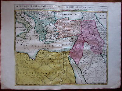
$11.85 Shipping Location: Dover, United States Carte Particuliere des Pais ou Les Apotres ont Preche l'Euan Gile; des Lieux les Plus Renommez de Leurs Voyages. Et de la Route de St. Paul a Rome. ... moreDressee pour bien entendre l'Histoire Sainte. Mediterranean. Arabia, Turkey, Greece, Armenia, North Africa) Issued Amsterdam. C. 1730-40 by Covens& Mortier. Fine mid-18th century engraved folio sheet map of the Mediterranean and Middle East. With original hand color. Quite interesting for the detailed depiction of Arabia. Armenia and Turkey during the time of the Apostles travels. In VG to near fine. Clean, well-preserved condition. A fine map. Sheet measures c. 24" W x 17" H. Printed area c. 18 1/4" W x 15" H. Folio. Tooleys Dictionary of Mapmakers. Vol. 1, p. 308. Marco van Egmond. Covens& Mortier. 3.3 R564. Everything we offer is guaranteed to be an authentic original antique item as described. We stand behind everything we sell. Important information for International Buyers* You may be charged customs. Taxes or other import duties by your country! this has nothing at all to do with us. Please do not hold us responsible if your Government wants to collect tax when you buy something outside of your country] Import duties. Taxes, and customs fees are not included in the item price or shipping cost. These charges are normally collected by the shipping service when the package is delivered or when you pick the item up. They are the buyer's responsibility and are not additional shipping charges. Please understand they have nothing to do with us and we have no control over them] Please check with your country's customs office to determine what these additional costs will be prior to bidding or buying. We do not know the various rules of your Customs office. There are a lot of countries in the world. Most with complex detailed variable laws in languages we don't read. Plus these laws are constantly being changed& revised] We won't under-value merchandise or mark the item as a gift on customs forms. Doing so is again
|
|
|
|
ANTIQUE PRINT FACADE AND TABERNACLE OF SOLOMON TEMPLE JERUSALEM ISRAEL 17th C
Original large etched FACADE OF SOLOMON's TEMPLE. SALOMONIS TEMPLUM, including interesting altars and other details, published by Jacob van Meurs. 1677 AD. This beautiful copperplate engraving is taken from' Nauwkeurige Beschrijving van gansch SYRIE. En PALENSTYN of Heilige Lant' door dr. Olfert Dapper. Amsterdam 1677 AD. The measurement of this engraving is 375*310 mm, the image is 360* 290 mm. A beautiful large copper engraved illustration of the Temple of one of the most famous travel accounts of th 17th century. With central fold as issued. The print is in good condition. The image therefore is clear. Fresh, and well inked. Please check the images. Printed on good quality 17th C lined paper. This antique print is excellent for framing. Thank you for looking. Worldwide shipping for this item is available for $ 9. Please note ... morethat shipping for additional items in the same shipment is free. Your item will be shipped within 1 or 2 days after your payment has been received. PayPal is preferred. Other payment methods are also fine. But may attract charges. If you have any questions. Please feel free to get in touch, preferably before bidding. Notwithstanding. If you are dissatisfied with your purchase you may return the item within 14 days and will be refunded the auctioned price.
|
|
|
1889 Antique AFGHANISTAN MAP w BELOOCHISTAN Vintage Collectible Map 1800s
ANTIQUE AFGHANISTAN COLLECTIBLE MAP This is an original. Not reproduction, vintage map which was carefully removed from an atlas. Item measures approximately 9" by 11" and is in very good condition. I happily combine purchases to save on shipping fees. Your item will be packaged in a plastic sleeve. And shipped in a cardboard mailing tube. Please email with questions. I will answer your email promptly! Be sure to add me to your! Check out my! Powered by The free listing tool. List your items fast and easy and manage your active items.
|
|
|
LARGE ANTIQUE PRINT SALOMON INAUGARATION TEMPLE JERUSALEM 18th C Very rare!
SALOMON TEMPLE INAUGURATION Salomon den Opbouw van den Tempel voltrokken hebbende. Doet daar van de Inwyding voor den Heere Salomon having completed the Resurrection of the Temple. Completing its Inaugaration before the Lord Published in a prestigious bible reference by August Calmet in 1729 AD. The title of this large copper engraved cityview is below the image. The measurement of the image is 440 X 320 mm. The sheet is 485* 365 mm. Verso is blank. The engraving is in good condition. Please check the images. This antique map is excellent for framing. Thank you for looking. Worldwide shipping for this item is free. Your item will be shipped within 1 or 2 days after your payment has been received. PayPal is preferred. Other payment methods are also fine. But may attract charges. If you have any questions. Please feel free to get in touch, ... morepreferably before bidding. Notwithstanding. If you are dissatisfied with your purchase you may return the item within 14 days and will be refunded the auctioned price.
|
|
|
Turkey Armenia Kurdistan Georgia Irak c.1855 Chapman & Hall antique color map
Turkey Armenia Kurdistan Georgia Irak c.1855 Chapman& Hall antique color map TURKEY IN ASIA GEORGIA& WESTERN PERSIA Issued London. C. 1855 by Chapman& Hall. Fine original antique color lithographed map. Made approximately 160 years ago. Printed in the mid 19th century, on quality paper which retains its inherent structural flexibility and soundness. Nicely detailed. Showing Kurdistan& Armenia in nice detail. In near VG or better condition[note: we grade very conservatively and always seek to disclose any noteworthy flaws] The printed area remains visually pleasing. A nice impression of an interesting image. Sheet measures c. 18" W x 12" H. Printed area measures c. 16 1/2" W x 11" H. Folio. Original fold line as issued. Two separately printed sheets. Joined by the publisher as issued. 9794] Any defects along ... morethe sheet edges and in the margins may be seen in the photos. note: All old sheets of printed paper possibly have short edge splits. Each sheet has existed for a very long time and has probably been handled repeatedly in the course of it's existence. It has a history unique to it as an object. Most of the time any edge splits are short. Minor, insignificant and have been closed- either long ago or more recently with small pieces of archival tape. Most often these splits are trivial and easy to overlook visually. Basically, they would not significantly affect the piece adversely. The item is offered as seen. Please look carefully and make your decision knowing this antique image is nice. But it is not in perfect"like new" condition. However, with whatever flaws it possesses, it remains entirely worthy of ownership and inclusion in any related collection. We feel it will prove very pleasing to its new owner. We stand behind everything we sell. Everything we offer is guaranteed to be an authentic original antique item as described. We do not sell modern reproductions. Please visit our. We happily accept PayPal!
|
|
|
1889 Antique PERSIA or IRAN Map Vintage Collectible Map 1800s
ANTIQUE PERSIA/ IRAN COLLECTIBLE MAP This is an original. Not reproduction, vintage map which was carefully removed from an atlas. Item measures approximately 9.5" by 12" and is in very good condition. I happily combine purchases to save on shipping fees. Your item will be packaged in a plastic sleeve. And shipped in a cardboard mailing tube. Please email with questions. I will answer your email promptly! Be sure to add me to your! Check out my! Powered by The free listing tool. List your items fast and easy and manage your active items. 46d.RcmdId ViewItemDescV4,RlogId p4%60bo7%60jtb9%3Fuk.rp*ed4%3E46d-13de0497e6d-0xf7-
|
|
|
Constantinople 1838 Ephesus Castle Aiasaluk by Allom
Constantinople 1838 Ephesus Castle Aiasaluk by Allom Ephesus The Castle of Aiasaluk in the distance. Issued c.1838. London, by Fisher, Son& Co. View art by Thomas Allom. Engraved by W.J. Cook. Finely detailed mid-19th century engraved view of Constantinople and environs. In near VG. Mostly clean condition. Some light scattered foxing and spotting as seen, blank margins with light minor soiling, but overall still a rich plate impression and visually pleasing. Nice contrast between darks and lights, almost unbelievable detail. Sheet measures c. 10 1/8" W x 7 7/8" H. Engraved area measures c. 7 1/4" W x 4 3/4" H. 632] Any defects along the sheet edges and in the margins may be seen in the photos. note: All old sheets of printed paper possibly have short edge splits. Each sheet has existed for a very long time and has ... moreprobably been handled repeatedly in the course of it's existence. It has a history unique to it as an object. Most of the time any edge splits are short. Minor, insignificant and have been closed- either long ago or more recently with small pieces of archival tape. Most often these splits are trivial and easy to overlook visually. Basically, they would not significantly affect the piece adversely. The item is offered as seen. Please look carefully and make your decision knowing this antique image is nice. But it is not in perfect"like new" condition. However, with whatever flaws it possesses, it remains entirely worthy of ownership and inclusion in any related collection. We feel it will prove very pleasing to its new owner. We stand behind everything we sell. Everything we offer is guaranteed to be an authentic original antique item as described. We do not sell modern reproductions. Please visit our. We happily accept PayPal! WE OFFER FLAT RATE SHIPPING WORLD WIDE! Please request an invoice before paying for multiple items so that we can ensure that you are not overcharged for shipping! To rec
|
|
|
Arabia Middle East great detail Mecca Medina 1816 Thomson folio antique map
INEXPENSIVE LOW COST GLOBAL SHIPPING ON ALL MAP/ PRINT ORDERS OVER $100* Arabia Middle East great detail Mecca Medina 1816 Thomson folio antique map Arabia. Egypt. Abyssinia, Red Sea&c. Issued London. 1816 by Thomson. Engraved by J. G. Menzies Fine antique engraved map printed in the early 19th century. Wonderful depiction of this region. With a profusion of interior details including many mountain ranges, engraved notes such as"the people use a particular dialect" myrrh and Incense Country" numerous caravan routes, etc. In VG condition. Light minor age wear, minor age spotting, light offsetting of minimal to no visual consequence, overall remaining clean and attractive. Pleasing example of this large original antique map. Sheet measures c. 21 1/4" H x 28 1/4" W. Engraved area measures c. 17 1/2" H x 19 1/2" ... moreW. Folio. Original fold line as issued. Tooleys Dictionary of Mapmakers. Vol. 4, p. 271. R258. Please look carefully and make your decision knowing this antique image is nice. But it is likely not in perfect"like new" condition. However, with whatever flaws it possesses, it remains entirely worthy of ownership and inclusion in any related collection. We feel it will prove very pleasing to its new owner. If not, simply return it for a prompt courteous refund. Everything we offer is guaranteed to be an authentic original antique item as described. We do not handle or deal in modern reproductions and stand behind everything we sell. Please visit our. NEW 2013 SHIPPING& TERMS: We are now offering inexpensive/ affordable World-wide economy shipping on all map/ print overs over $100! $25 flat-rate insured shipping to anywhere in the world on all map orders over $100* This is substantially less than it will actually cost us. In order to receive this reasonable low cost Global map shipping. Please request an invoice from us prior to paying. All orders below $100 pay- Outside U.S.A. $35 Priority Airmail Insured Inside U.S. $4.95 Prior
|
|
|
South Western Turkmenistan explorations of Lessar 1885 original antique map
South Western Turkmenistan explorations of Lessar 1885 original antique map Map of South Western Turkomania(According to the Explorations of M. Lessar) Issued 1885 Fine original antique map. Printed on quality paper which retains its inherent structural flexibility and soundness. In Very Good or better condition[note: we grade very conservatively and always seek to disclose any noteworthy flaws] The printed area remains pleasing. A nice impression that would look great framed. Original Fold Line as issued. Sheet measures c. 8" W x 9 1/2" H. Engraved area measures c. 6 1/4" W x 8 1/2" H. 22965] note: All old sheets of printed paper possibly have short edge splits. Each sheet has existed for a very long time and has probably been handled repeatedly in the course of it's existence. It has a history unique to it as an ... moreobject. Most of the time any edge splits are short. Minor, insignificant and have been closed- either long ago or more recently with small pieces of archival tape. Most often these splits are trivial and easy to overlook visually. Basically, they would not significantly affect the piece adversely. The item is offered as seen. Please look carefully and make your decision knowing this antique image is nice. But it is not in perfect"like new" condition. However, with whatever flaws it possesses, it remains entirely worthy of ownership and inclusion in any related collection. We feel it will prove very pleasing to its new owner. We stand behind everything we sell. Everything we offer is guaranteed to be an authentic original antique item as described. We do not sell modern reproductions. Please visit our. We happily accept PayPal! WE OFFER FLAT RATE SHIPPING WORLD WIDE! Please request an invoice before paying for multiple items so that we can ensure that you are not overcharged for shipping! To receive our flat rate shipping rates you must request or wait for an invoice. We can no longer refund exces
|
|
|
Turkish Royalty Priests native costumes c.1780 Turkey antique engravings
Turkish Royalty Priests native costumes c.1780 Turkey antique engravings Turkish Dresses The Grand Vizier- The Sultaness- The Grand Seignior/ A Turkish Priest- a Bashaw- The Inman of the Mosque Issued c. 1780. London; for Bankes. Fine original antique engraving. Made approximately 230 years ago. Printed in 18th century England. On quality hand-made rag paper which retains its inherent structural flexibility and soundness. Created to illustrate a voyage of exploration and discovery across the world to the Southern Ocean and Pacific region. In the 18th century. Engraved illustrations such as this one were the primary method by which a person could see images of far away and exotic places. Voyages of discovery were then popular topics of discussion and men such as Dampier and Capt. Cook were heroes of their time. These"popular" types ... moreof prints were often sold individually and as part of illustrated travel accounts. All of which are now scarce and sought after today. They represent a unique visual record of a bygone era and are great conversational items once framed for display. When you stop to consider their age and the fact they are original engraved works of art. It's amazing how affordable they actually are. In Good+ or better condition. Some light small staining or minor spotting, minor normal paper wrinkling and age wear, most of which is visible in the photos[note: we grade very conservatively and always seek to disclose any noteworthy flaws] Many people would consider this engraving VG to VG+. The printed area remains visually attractive. A pleasing impression of an interesting mid-18th century engraved image. Well worthy of display. Any defects along the sheet edges and in the margins may be seen in the photos. Sheet measures c. 14 3/4" H x 9 1/4" W. Two engraved areas on the sheet. Each one measures c. 4 3/4" H x 7" W. 12308] note: All old sheets of printed paper possibly have short edge splits. Each sheet has existed for a very long time and has probably been handled repe
|
|
|
Arabia Middle East Persia Turkey Armenia 1867 Johnson color antique map folio
Arabia Middle East Persia Turkey Armenia 1867 Johnson color antique map folio JOHNSON'S TURKEY IN ASIA/ JOHNSON'S PERSIA, ARABIA, BELOOCHISTAN AND AFGHANISTAN(2 maps on 1 sheet) Issued New York. 1867 by Johnson. Attractive mid 19th century folio lithographed map. With original hand color. Wonderfully detailed. In good+. Mostly clean condition. Some light toning and spotting- mainly to margins and hardly offensive- as well as a few short edge splits which have been cleanly mended with archival tape. Otherwise map remains clean and quite well-preserved. Will look great displayed. Sheet measures c. 18" W x 26 1/4" H. Printed area measures c. 15 1/4" W x 22" H. Folio. Original fold line as issued. 5954] Any defects along the sheet edges and in the margins may be seen in the photos. note: All old sheets of printed paper ... morepossibly have short edge splits. Each sheet has existed for a very long time and has probably been handled repeatedly in the course of it's existence. It has a history unique to it as an object. Most of the time any edge splits are short. Minor, insignificant and have been closed- either long ago or more recently with small pieces of archival tape. Most often these splits are trivial and easy to overlook visually. Basically, they would not significantly affect the piece adversely. The item is offered as seen. Please look carefully and make your decision knowing this antique image is nice. But it is not in perfect"like new" condition. However, with whatever flaws it possesses, it remains entirely worthy of ownership and inclusion in any related collection. We feel it will prove very pleasing to its new owner. We stand behind everything we sell. Everything we offer is guaranteed to be an authentic original antique item as described. We do not sell modern reproductions. Please visit our. We happily accept PayPal! WE OFFER FLAT RATE SHIPPING WORLD WIDE! Please request an invoice before paying fo
|
|
|
Persia Arabia 1865 Colton scarce antique map
Persia Arabia 1865 Colton scarce antique map Persia. Arabia& c. Issued 1865. NY by J.H. Colton Fine original antique map. Made approximately 150 years ago. Printed in the mid-19th century, on quality paper which retains its inherent structural flexibility and soundness. Original hand color. Map is set within an intricate engraved border. A scarce 1865 re-issue of Colton's earlier map. Indeed. The imprint on the map is earlier than 1865, but it was re-issued in 1865, so it may display variations from the earlier appearance. In near VG or better condition. Light minor age wear, overall very presentable and attractive[note: we grade very conservatively and always seek to disclose any noteworthy flaws] The printed area remains visually pleasing. A fine impression of an interesting antique map which will look nice when displayed. Sheet ... moremeasures c. 17 1/4" W x 14 1/4" H. Printed area measures c. 15 1/2" W x 12 1/2" H. 17688] Any defects along the sheet edges and in the margins may be seen in the photos. note: All old sheets of printed paper possibly have short edge splits. Each sheet has existed for a very long time and has probably been handled repeatedly in the course of it's existence. It has a history unique to it as an object. Most of the time any edge splits are short. Minor, insignificant and have been closed- either long ago or more recently with small pieces of archival tape. Most often these splits are trivial and easy to overlook visually. Basically, they would not significantly affect the piece adversely. The item is offered as seen. Please look carefully and make your decision knowing this antique image is nice. But it is not in perfect"like new" condition. However, with whatever flaws it possesses, it remains entirely worthy of ownership and inclusion in any related collection. We feel it will prove very pleasing to its new owner. We stand behind everything we sell. Everything we offer is guaranteed to be an authentic original antique item as described. We do not
|
|
|
Turkey Persia Arabia 1891 Tunison antique lithographed hand color map
Turkey Persia Arabia 1891 Tunison antique lithographed hand color map Tunison's Turkey in Asia. Persia, Arabia, Russian Turkestan, Afghanistan and Beloochistan Issued 1891. Chicago, Tunison Fine original lithographed antique map. Printed in the late-19th century, on quality paper which retains its inherent structural flexibility and soundness. With original hand color. In VG or better condition. Light minor age wear, overall very presentable and attractive[note: we grade very conservatively and always seek to disclose any noteworthy flaws] The printed area remains visually pleasing. A nice impression of an interesting antique map which will look nice when displayed. Sheet measures c. 13 7/8" W x 11 1/4" H. Printed area measures c. 12" W x 9 3/4" H. 19047] Any defects along the sheet edges and in the margins may be ... moreseen in the photos. note: All old sheets of printed paper possibly have short edge splits. Each sheet has existed for a very long time and has probably been handled repeatedly in the course of it's existence. It has a history unique to it as an object. Most of the time any edge splits are short. Minor, insignificant and have been closed- either long ago or more recently with small pieces of archival tape. Most often these splits are trivial and easy to overlook visually. Basically, they would not significantly affect the piece adversely. The item is offered as seen. Please look carefully and make your decision knowing this antique image is nice. But it is not in perfect"like new" condition. However, with whatever flaws it possesses, it remains entirely worthy of ownership and inclusion in any related collection. We feel it will prove very pleasing to its new owner. We stand behind everything we sell. Everything we offer is guaranteed to be an authentic original antique item as described. We do not sell modern reproductions. Please visit our. We happily accept PayPal! WE OFFER FLAT RATE SHIPPING W
|
|
|
Iran Turkestan Afghanistan Tehran Persia 1867 Stieler original antique map
Iran Turkestan Afghanistan Tehran Persia 1867 Stieler original antique map IRAN und TURAN oder Persien. Afghanistan, Belutschistan& Turkestan. Persia/ Iran) Issued c. 1867. Gotha Germany by Perthes for Stieler Fine antique engraved map. With original outline hand color. Made approximately 140 years ago. Printed in the mid-19th century, on quality paper which retains its inherent structural flexibility and soundness. A beautifully engraved and very detailed map of this region. With a profusion of details and small towns not often seen. The key identifies by color the various political powers possessions at this time. In near VG or better condition. Some light scattered foxing as typical[note: we grade very conservatively and always seek to disclose any noteworthy flaws] The printed area remains visually pleasing, a nice impression of an ... moreinteresting map. Sheet measures c. 15" H x 18 1/4" W. Engraved area measures c. 12 1/4" H x 15 3/4" W. 9906] Any defects along the sheet edges and in the margins may be seen in the photos. note: All old sheets of printed paper possibly have short edge splits. Each sheet has existed for a very long time and has probably been handled repeatedly in the course of it's existence. It has a history unique to it as an object. Most of the time any edge splits are short. Minor, insignificant and have been closed- either long ago or more recently with small pieces of archival tape. Most often these splits are trivial and easy to overlook visually. Basically, they would not significantly affect the piece adversely. The item is offered as seen. Please look carefully and make your decision knowing this antique image is nice. But it is not in perfect"like new" condition. However, with whatever flaws it possesses, it remains entirely worthy of ownership and inclusion in any related collection. We feel it will prove very pleasing to its new owner. We stand behind everything we sell. Everything we offer is guaranteed to be an authentic original antique item as d
|
|
|
Imperial Alexandria Alexander Empire Arabia c.1820 antique engraved map
Imperial Alexandria Alexander Empire Arabia c.1820 antique engraved map Impero d'ALESSANDRO(Empire of Alexander) Issued Italy: c. 1820. Fine original antique engraved map. Made approximately 190 years ago. Printed in the early-19th century in Italy, on quality paper which retains its inherent structural flexibility and soundness. In near VG or better condition. Centerfold lightly toned as seen[note: we grade very conservatively and always seek to disclose any noteworthy flaws] The printed area remains visually pleasing. A nice impression of an interesting antique map. Any minor defects along the sheet edges and in the margins may be seen in the photos. Original centerfold as issued. Sheet measures c. 11 1/4" W x 9" H. Engraved area measures c. 7 1/2" W x 5 1/2" H. 15251] note: All old sheets of printed paper possibly ... morehave short edge splits. Each sheet has existed for a very long time and has probably been handled repeatedly in the course of it's existence. It has a history unique to it as an object. Most of the time any edge splits are short. Minor, insignificant and have been closed- either long ago or more recently with small pieces of archival tape. Most often these splits are trivial and easy to overlook visually. Basically, they would not significantly affect the piece adversely. The item is offered as seen. Please look carefully and make your decision knowing this antique image is nice. But it is not in perfect"like new" condition. However, with whatever flaws it possesses, it remains entirely worthy of ownership and inclusion in any related collection. We feel it will prove very pleasing to its new owner. We stand behind everything we sell. Everything we offer is guaranteed to be an authentic original antique item as described. We do not sell modern reproductions. Please visit our eBay Store. We happily accept PayPal! WE OFFER FLAT RATE SHIPPING WORLD WIDE! Please request an invoice before paying
|
|
|
East Africa Arabia w/ interior detail c.1875 Bartholomew folio antique Zell map
East Africa Arabia w/ interior detail c.1875 Bartholomew folio antique Zell map Turkey in Asia. Persia. Arabia, Egypt& Nile Countries Issued Philadelphia. C.1875 by J. Bartholomew for Zell. Fine original antique engraved map with printed color. Printed on quality paper which retains its inherent structural flexibility and soundness. In near VG or better condition. Small chip to top right corner blank margin[note: we grade very conservatively and always seek to disclose any noteworthy flaws] The printed area remains visually pleasing, a nice impression of an interesting map. Shows quite a bit of interior detail for these locations. Any minor defects along the sheet edges and in the margins may be seen in the photos. Original centerfold as issued. Sheet measures c. 12 1/4" W x 17" H. Engraved area measures c. 11 1/2" W x ... more16" H. Folio sheet. 17760] note: All old sheets of printed paper possibly have short edge splits. Each sheet has existed for a very long time and has probably been handled repeatedly in the course of it's existence. It has a history unique to it as an object. Most of the time any edge splits are short. Minor, insignificant and have been closed- either long ago or more recently with small pieces of archival tape. Most often these splits are trivial and easy to overlook visually. Basically, they would not significantly affect the piece adversely. The item is offered as seen. Please look carefully and make your decision knowing this antique image is nice. But it is not in perfect"like new" condition. However, with whatever flaws it possesses, it remains entirely worthy of ownership and inclusion in any related collection. We feel it will prove very pleasing to its new owner. We stand behind everything we sell. Everything we offer is guaranteed to be an authentic original antique item as described. We do not sell modern reproductions. Please visit our eBay Store. We happily accept PayPal! WE OF
|
|
|
Iran Tehran Afghanistan Armenia 1853 Stieler antique folio engraved color map
Iran Tehran Afghanistan Armenia 1853 Stieler antique folio engraved color map IRAN UND TURAN. Persien. Afghanistan, Beludchistan, Turkestan, Issued c. 1853. Gotha Germany by Perthes for Stieler Fine original antique engraved map. With original outline hand color. Made approximately 160 years ago. Printed in the mid-19th century, on quality paper which retains its inherent structural flexibility and soundness. A beautifully engraved and very detailed map of this region. In near VG or better condition. Some light scattered foxing as typical, light toning, and some light to moderate dampstaining along top margin- none of which are visually offensive and are overall very easy to overlook[note: we grade very conservatively and always seek to disclose any noteworthy flaws] The printed area remains visually pleasing. A nice impression of an interesting ... moreand surprisingly uncommon Stieler map. Sheet measures c. 17 3/4" W x 14 1/2" H. Engraved area measures c. 14" W x 13 1/4" H. Folio. Original fold line as issued. 14729] Any defects along the sheet edges and in the margins may be seen in the photos. note: All old sheets of printed paper possibly have short edge splits. Each sheet has existed for a very long time and has probably been handled repeatedly in the course of it's existence. It has a history unique to it as an object. Most of the time any edge splits are short. Minor, insignificant and have been closed- either long ago or more recently with small pieces of archival tape. Most often these splits are trivial and easy to overlook visually. Basically, they would not significantly affect the piece adversely. The item is offered as seen. Please look carefully and make your decision knowing this antique image is nice. But it is not in perfect"like new" condition. However, with whatever flaws it possesses, it remains entirely worthy of ownership and inclusion in any related collection. We feel it will prove very pleasing to its new owner. We stand behind everything we sell. Everything we
|
|
|
1750 Antique Print of the British Fort in Surat, Gujarat, India
Helpful Links: Company Details- About ME View seller's other items Cartographer's Profile Ask Seller a q uestion Return Policy We have over 2.000 items for sale on our Ebay stores site. Please click here to enter the stores and use the search engine to the left to search specifically for maps. Prints, Atlases on the Classical Images Stores. Thank you A View of the Castle of Surat click image to enlarge This beautifully hand coloured original antique print a view of the British Fort in Surat in the Gujarāt State, India was published in England in 1750. Ref: M&B; Tooley) Please note all items auctioned are genuine. We do not sell reproductions. A Certificate of Authenticity(COA) can be issued on request. Condition Report General Description: Paper thickness and quality: Heavy& stable Paper color: White Age of map color: Early ... moreColors used: Red. Green, blue, brown General color appearance: Authentic Paper size: 8 1/2i n x 5i n( 220 mm x 130m m) P late size: 7i n x 4i n( 180 mm x 100m m) Margins: Min 1/2 in( 12m m) Imperfections: Margins: None Plate area: None Verso: None Overall Quality(in Bold) Perfect/ Fine/Very Good/Good/Fair/Poor Payment Methods Visa MasterCard Bankcard* PayPal Direct Bank Transfers& AUS$ Bank Drafts Please contact me to discuss other forms of payment Please also contact me before the end of the auction if you would like to discuss payment by installments over an agreed period Australian buyers please add 10% GST* Please email your CC# Expiry Date, full name on card& shipping address in two separate emails or alternatively you can fax or phone to the numbers below. Shipping Worldwide Australia Air Mail Courier1 Courier2* Express Insurance $ 10.00 US, $ 30.00 US, $12.00 US 2.75% min $6.00 US, $ 6.00 US, 2.75% min $4.00 US, Courier#2: Available for all items 11in x 8 1/2in(280mm x 215mm) or smaller flat or folded along original folds. Airmail shipping from Australia to Europe or the US takes approx. 5-7 days. EMS courier will take 3-5 days. There w
|
|
|
ANTIQUE MAP OF ASIA MINOR, TURKEY BY JOHN RAPKIN CIRCA 1865
ASIA MINOR. A highly decorative map of Asia Minor originally issued by John Tallis. Probably one of the best known map-makers and publishers of the 19th Century. The maps were published circa 1850 and are considered the last series of decorative maps of the world, Contained within an elaborate border the maps were generally decorated with vignettes and scenes depicting particular views and local inhabitants. The present map of"Asia Minor" dates from a later publication circa 1865 and has no vignettes, but retains the decorative border. The map was drawn and engraved by John Rapkin. Attractive hand colour. Engraved surface measures approx. 255 x 325 mm. Good condition. See photo for condition. For further information please feel free to contact us. A guaranteed genuine antique map. SEE MORE GENUINE ANTIQUE MAPS AND PRINTS IN MY SHOP ... moreON EBAY.CO.UK
|
|
|
Middle East Iran Turkey Arabia Cyprus Parthian Empire c.1780 Bonne antique map
Middle East Iran Turkey Arabia Cyprus Parthian Empire c.1780 Bonne antique map Imperii PArthorum Tabula Pars Occidentalis(Parthian Empire) Issued 1780. Paris by R. Bonne Fine original antique engraved map. Printed in the late 18th century, on quality hand-made paper which retains its inherent structural flexibility and soundness. An uncommon version of this Bonne map. With the date printed below the title. With original outline hand color. In near VG or better condition. Light minor age wear, light toning to sheet, but overall very presentable and attractive[note: we grade very conservatively and always seek to disclose any noteworthy flaws] The printed area remains visually pleasing. A nice impression of an interesting antique map which will look nice when displayed. Sheet measures c. 11 1/4" W x 16" H. Printed area measures c. ... more9 1/4" W x 13 1/2" H. Original fold line as issued. 27568] Any defects along the sheet edges and in the margins may be seen in the photos. note: All old sheets of printed paper possibly have short edge splits. Each sheet has existed for a very long time and has probably been handled repeatedly in the course of it's existence. It has a history unique to it as an object. Most of the time any edge splits are short. Minor, insignificant and have been closed- either long ago or more recently with small pieces of archival tape. Most often these splits are trivial and easy to overlook visually. Basically, they would not significantly affect the piece adversely. The item is offered as seen. Please look carefully and make your decision knowing this antique image is nice. But it is not in perfect"like new" condition. However, with whatever flaws it possesses, it remains entirely worthy of ownership and inclusion in any related collection. We feel it will prove very pleasing to its new owner. We stand behind everything we sell. Everything we offer is guaranteed to be an authentic original antique item as described. We do not sell modern reproductions. Please visit o
|
|
|
Syria Asia Minor Cyprus 1828 Arrowsmith antique engraved map old hand color
Syria Asia Minor Cyprus 1828 Arrowsmith antique engraved map old hand color SYRIA(with the island of Cyprus) Issued London: 1828; by S. Arrowsmith. Fine original antique engraved map. Made approximately 184 years ago. Nicely detailed, with original full hand color, heightened in outline, and nice topographic detail. Beautifully engraved and printed on heavy paper. In very VG or better condition[note: we grade very conservatively and always seek to disclose any noteworthy flaws] The printed area remains visually pleasing. Any minor defects along the sheet edges and in the margins may be seen in the photos. Sheet measures c. 11" W x 13 3/4" H. Engraved area measures c. 8 3/4" W x 11 1/4" H. 12885] note: All old sheets of printed paper possibly have short edge splits. Each sheet has existed for a very long time and has probably ... morebeen handled repeatedly in the course of it's existence. It has a history unique to it as an object. Most of the time any edge splits are short. Minor, insignificant and have been closed- either long ago or more recently with small pieces of archival tape. Most often these splits are trivial and easy to overlook visually. Basically, they would not significantly affect the piece adversely. The item is offered as seen. Please look carefully and make your decision knowing this antique image is nice. But it is not in perfect"like new" condition. However, with whatever flaws it possesses, it remains entirely worthy of ownership and inclusion in any related collection. We feel it will prove very pleasing to its new owner. We stand behind everything we sell. Everything we offer is guaranteed to be an authentic original antique item as described. We do not sell modern reproductions. Please visit our eBay Store. We happily accept PayPal! WE OFFER FLAT RATE SHIPPING WORLD WIDE! Please request an invoice before paying for multiple items so that we can ensure that you are not overcharged for sh
|
|
|
Turkey Cyprus Palestine Middle East Israel 1850 Flemming antique map old color
Turkey Cyprus Palestine Middle East Israel 1850 Flemming antique map old color ASIATISCHE TURKEI Issued 1850; Glogau. Germany by C. Flemming. Fine original antique lithographed map. With original outline hand color. Made approximately 160 years ago. Printed in the mid-19th century, on quality paper which retains its inherent structural flexibility and soundness. In Good+[to near VG] or better condition. Light age dusting, small minor surface speckling or light foxing, margins toned[note: we grade very conservatively and always seek to disclose any noteworthy flaws] The printed area remains visually pleasing. A nice impression of an interesting and remarkably detailed map. Very nicely printed lithography, typical German precision and fine attention to detail. Sheet measures c. 17" W x 13 3/4" H. Printed area measures c. 15" ... moreW x 11 1/2" H. Folio sheet. 15656] Any defects along the sheet edges and in the margins may be seen in the photos. note: All old sheets of printed paper possibly have short edge splits. Each sheet has existed for a very long time and has probably been handled repeatedly in the course of it's existence. It has a history unique to it as an object. Most of the time any edge splits are short. Minor, insignificant and have been closed- either long ago or more recently with small pieces of archival tape. Most often these splits are trivial and easy to overlook visually. Basically, they would not significantly affect the piece adversely. The item is offered as seen. Please look carefully and make your decision knowing this antique image is nice. But it is not in perfect"like new" condition. However, with whatever flaws it possesses, it remains entirely worthy of ownership and inclusion in any related collection. We feel it will prove very pleasing to its new owner. We stand behind everything we sell. Everything we offer is guaranteed to be an authentic original antique item as described. We do not sell modern reproductions. Please visit our.
|
|
|
Russian Turkish Forces Constantinople 1878 The Graphic antique map & prints
Russian Turkish Forces Constantinople 1878 The Graphic antique map& prints The Crisis in the East: New Russian Battery on the South Side of the Mouth of the Danuse. Relative Positions of the Russian and Turkish Forces, and of the British Forces before Constantinople& New Russian Battery on the North Side of the Mouth of the Danure Issued 1878 The Graphic. Fine original antique wood engraved images. Including an uncommon detailed map relating to military actions of this time. Printed in the late 19th century, on quality paper which retains its inherent structural flexibility and soundness. Map shows the positions of Russian& Turkish forces. In near VG or better condition. Overall very clean, light minor crease down middle of print which in no way detracts visually[note: we grade very conservatively and always seek to disclose any ... morenoteworthy flaws] Text on verso as issued. The printed area remains visually pleasing. A nice impression of an interesting image. Any minor defects along the sheet edges and in the margins may be seen in the photos. Sheet measures c. 15 3/4" H x 11 5/8" W. Engraved area measures c. 12 1/4" H x 8 7/8" W. 22376] Any defects along the sheet edges and in the margins may be seen in the photos. note: All old sheets of printed paper possibly have short edge splits. Each sheet has existed for a very long time and has probably been handled repeatedly in the course of it's existence. It has a history unique to it as an object. Most of the time any edge splits are short. Minor, insignificant and have been closed- either long ago or more recently with small pieces of archival tape. Most often these splits are trivial and easy to overlook visually. Basically, they would not significantly affect the piece adversely. The item is offered as seen. Please look carefully and make your decision knowing this antique image is nice. But it is not in perfect"like new" condition. However, with whatever flaws it possesses, it remains entirely worthy of ownership and in
|
|
|
Asia Minor Armenia Turkey Mesopotamia Palestine Babylon 1875 Brue antique map
Asia Minor Armenia Turkey Mesopotamia Palestine Babylon 1875 Brue antique map Carte Generale de L'Asie Mineure et L'Armenie de la Syrie de la Mesopotamie du Caucase(Asia Minor) Issued 1875. Paris by A. Brue& Delagrave Revised by Levasseur Fine original antique engraved folio sheet map. Printed on quality paper which retains its inherent structural flexibility and soundness. Beautifully engraved and set within a piano key border. With beautiful original hand color. In near VG or better condition[note: we grade very conservatively and always seek to disclose any noteworthy flaws] An uncommon and remarkably detailed map with hundreds of small towns. The printed area remains visually pleasing. A nice impression of an interesting antique map. Any minor defects along the sheet edges and in the margins may be seen in the photos. Sheet ... moremeasures c. 23 7/8" W x 18 5/8" H. Engraved area measures c. 20 1/8" W x 14 1/4" H. Original centerfold line as issued. 31553] note: All old sheets of printed paper possibly have short edge splits. Each sheet has existed for a very long time and has probably been handled repeatedly in the course of it's existence. It has a history unique to it as an object. Most of the time any edge splits are short. Minor, insignificant and have been closed- either long ago or more recently with small pieces of archival tape. Most often these splits are trivial and easy to overlook visually. Basically, they would not significantly affect the piece adversely. The item is offered as seen. Please look carefully and make your decision knowing this antique image is nice. But it is not in perfect"like new" condition. However, with whatever flaws it possesses, it remains entirely worthy of ownership and inclusion in any related collection. We feel it will prove very pleasing to its new owner. We stand behind everything we sell. Everything we offer is guaranteed to be an authentic original antique item as described. We do not sell modern reproductions. Please visit ou
|
|
|
Antique Map, PLAN OF JERUSALEM, ISRAEL,Francois Halma, 1717
iscra antique maps& prints'Vera Hierosolymae veteris imago' Description: Antique map of an imaginary plan of Jerusalem drawn after Villalpando. Published by Francois Halma, printed in 1717. Size: The overall size is 15,5 x 9,5 inch. The image size is 12,5 x 8 inch. Technic: copper engraving. Condition: Very Good; two folds as issued. A Certificate of Authenticity will be added! THERE IS FREE SHIPPING FOR ADDITIONAL ITEMS! Thanks for looking! ISCRA STORE* We accept Paypal payments and Bank transfer payments! Combined orders possibl e! Insurance included! ISCRA- store ISCRA is a member of the international antiquarian map sellers association Because of different configurations of monitors colours can appear a bit different on you screen. The sizes of the pictures are(most of the time) not the real print size. The real sizes are ... morenoted in the description area. Import duties. Taxes and charges are not included in the item price or shipping cost and are buyer's responsibility. WE GUARANTEE ITEMS SOLD ARE IN THE CONDITION DESCRIBED. ITEMS CAN BE RETURNED WITHIN 14 DAYS after delivery or pick-up date Powered by The free listing tool. List your items fast and easy and manage your active items.
|
|
|
Samoyedic - Russia - Wahlen 1843
Title: Samoyedes(Asie) Age: 1843(Bruxelles) Author: Auguste Wahlen Editor: Libraire Historique-Artistique Technique: hand-coloured lithography litografia a colori originali d'epoca lithographie aux couleurs d'epoque Note: from"Moeurs. Usages et costumes de touts les peuples du Monde" Dimensions: Sheet 26cm x 17.5cm Conditions: small stains(look photo) Condizioni: piccole macchie(vedere foto) Conditions: petites taches(voir photo) Shipping: If you buy more than one item you have to pay just one only shipping cost(registered mail) Shipping cost: Italy 8.50 USD Europe 12.50 USD America(North-South) Africa 14.50 USD Asia-Oceania 17.50 USD WE DON'T SELL LASER COPY OR SCANNER. THIS AN ORIGINAL ENGRAVING FROM 1843 On Aug-27-07 at 08:51:41 PDT. Seller added the following information:
|
|
|
FINE LARGE ANTIQUE TEESDALE MAP, c1844, ANCIENT PALESTINE & PLAN OF JERUSALEM
FINE 1844 LARGE ANTIQUE TEESDALE MAP ANCIENT PALESTINE Description: FINE LARGE NINTEENTH CENTURY STEEL-LINED ENGRAVED MAP OF THE ANCIENT PALESTINE. DRAWN AND ENGRAVED BY J. DOWER AND PUBLISHED BY HENRY TEESDALE, LONDON, c1844. A large finely detailed nineteenth century steel-lined engraved map. Neatly hand-coloured in outline, of Ancient Palestine, engraved by J. Dower and published by Henry Teesdale, in London, c1844. The double-page map with an inset plan of Jerusalem and a reference list to the Twelve Tribes. With printed title and a separate scale of distance. Image size approx. 34cm x 41cm(13.25in x 16.5in) A generally VG+ bright clean impression of this detailed map. All maps will be sent out in board-backed envelopes for extra protection. A GURANTEED GENUINE ORIGINAL NINETEENTH CENTURY MAP Shipping UK Recorded Delivery £4.00 Europe ... morePrinted Papers(2-5 days) £5.00 U.S.A. and the Rest of the World Printed Papers(up to 5 days) £6.00*Reduced shipping for multiple purchases Payment: What payment methods are taken and by when should payment be made? I offer a variety of payment methods. UK customers can pay by PayPal. Direct by credit card, postal order and personal cheque. Non-UK customers can pay by PayPal, or by an alternative method if agreed prior to purchase. Payment should be received within 7 days of purchase unless otherwise agreed. I reserve the right to relist an item for sale if payment is not made at the latest within one month of purchase. Payment protection cover Customers who pay by PayPal are automatically covered by PayPal's Buyer Protection scheme up to £500 assuming buyer and seller meet certain criteria. See PayPal's website at www.paypal.com for terms. Likewise, other buyers are automatically covered by eBay's Standard Purchase Protection Programme up to £120 as long as certain criteria are met. See eBay's website at www.ebay.co.uk for terms. What is PayPal? PayPal is a secure payment system owned by eBay which allows customers and merchants to exchan
|
|
|
1843 Antique Map of "Modern Jerusalem" - Three City Walks - William Hughes
An original antique map of"Modern Jerusalem" engraved by William Hughes and published in his" Palestine in the Time of Our Savior" in 1843. Hand colored additions illustrating the route of three city walks presumably recommended by the author in the text. Good condition with minor scuffs and surface dirt. Page size 13 x 10 inches with horizontal folds where incorporated into the publication.
|
|
|
1784 MAP BY M BARBIE DU BOCAGE ESSAY ON THE BATTLE OF PLATAEA TRAVELS ANACHARSIS
This map is entitled"Essay on the Battle of Plataea" and was drawn by M. Barie Du Bocage February 1784 and is"Designed entirely from the Accounts given by Ancient Authors" It came out of a book published in the 1790's entitled"The Travels of Anacharsis" It measures 9 1/4 x 14 inches and is trimmed close on the left and bottom sides. Guaranteed original and authentic. Shipping includes insurance. International shipping is $10. RcmdId ViewItemDescV4,RlogId p4%60bo7%60jtb9%3Fuk.rp*05e54c%3E-13df5146de8-0xf9-
|
|
|
Aceldema Israel Valley of Jehosaphat view 1670 antique engraved map
Aceldema Israel Valley of Jehosaphat view 1670 antique engraved map Aceldema(valley of Jehosaphat) Printed 1670. London by Chetwin Fine original antique engraved view. Made approximately 340 years ago. Printed in the mid-17th century, on quality paper which retains its inherent structural flexibility and soundness. Text around the engraving as well on the back, as always and as issued. In near VG or better condition. Minor waviness to sheet as typical of hand-made 17th century paper[note: we grade very conservatively and always seek to disclose any noteworthy flaws] The printed area remains visually pleasing. A nice impression of a very interesting birds-eye view. Below the view, 7 specific locations are identified. The strapwork title cartouche and compass rose impart a charming visual quality to the image. On the back is a similar view ... moreof" The Mountaines of Juda" Sheet measures c. 11 1/2" H x 7" W. Printed area measures c. 3 3/4" H x 5" W. 10763] Any defects along the sheet edges and in the margins may be seen in the photos. note: All old sheets of printed paper possibly have short edge splits. Each sheet has existed for a very long time and has probably been handled repeatedly in the course of it's existence. It has a history unique to it as an object. Most of the time any edge splits are short. Minor, insignificant and have been closed- either long ago or more recently with small pieces of archival tape. Most often these splits are trivial and easy to overlook visually. Basically, they would not significantly affect the piece adversely. The item is offered as seen. Please look carefully and make your decision knowing this antique image is nice. But it is not in perfect"like new" condition. However, with whatever flaws it possesses, it remains entirely worthy of ownership and inclusion in any related collection. We feel it will prove very pleasing to its new owner. We stand behind everything we sell. Everything we offer is guaranteed to be an authentic original antiq
|
|
|
Turkey Asia Minor Palestine Syria Armenia c.1897 antique color folio map
Turkey Asia Minor Palestine Syria Armenia c.1897 antique color folio map Turkey is Asia(Asia Minor(Anatolia) Armenia, Kurdistan, Mesopotamia and Syria) with Parts of Russian Trans-Caucasia Issued c.1897. Buffalo, New York by Matthews-Northup Co. Fine original antique offset color map. Printed on quality paper which retains its inherent structural flexibility and soundness. Very detailed. With an extensive key which includes things such as active volcanoes during the 19th century, battlefields, submarine telegraph lines, steamship lines, and much more. In near VG or better condition. Light minor age wear, but the image remains clean, attractive, and very presentable[note: we grade very conservatively and always seek to disclose any noteworthy flaws] The printed area remains visually pleasing. A nice impression of an interesting antique map. ... moreAny minor defects along the sheet edges and in the margins may be seen in the photos. Sheet measures c. 16 1/4" W x 11 1/2" H. Engraved area measures c. 14 7/8" W x 10 3/8" H. Original fold line as issued. 37241] note: All old sheets of printed paper possibly have short edge splits. Each sheet has existed for a very long time and has probably been handled repeatedly in the course of it's existence. It has a history unique to it as an object. Most of the time any edge splits are short. Minor, insignificant and have been closed- either long ago or more recently with small pieces of archival tape. Most often these splits are trivial and easy to overlook visually. Basically, they would not significantly affect the piece adversely. The item is offered as seen. Please look carefully and make your decision knowing this antique image is nice. But it is not in perfect"like new" condition. However, with whatever flaws it possesses, it remains entirely worthy of ownership and inclusion in any related collection. We feel it will prove very pleasing to its new owner. We stand behind everything we sell. Everything we offer is guaranteed to be an authentic or
|
|
|
1892 Antique COLOR Map/EGYPT, PHOENICIA, PALESTINE As Known to the Ancients
THIS ITEM IS A GENUINE ORIGINAL VINTAGE MAP FROM THE SOURCE/DATE LISTED Name- Aegyptus– Phoenice et Palaestina(Egypt. Phoenicia, Palestine) Date- 1892 Source- Atlas Antiquus. By Dr. Henry Kiepert Publisher- Leach. Shewell and Sanborn, Boston Comment- One of a series of excellent maps of the Ancient World. Prepared by Dr. Kiepert Map Features- details of city of Alexandria and Hierosylyma(Jerusalem) And Israelitarum Size- about 14.25x17.75" Double page, blank backed Condition- Fine Yes! We Do Combine Shipping on Multiple Purchases! NO RESERVE! Happy Bidding! Buyer pays shipping/packing. We use very secure packaging methods and materials. And all shipments within the United States will be made with the protection of the new USPS Parcel shipping category. First Class or Priority. Depending on weight) Note that certain items may be shipped ... morein the USPS Media Mail category. If appropriate. Payment due within 14 days after our initial after auction contact. Pennsylvania residents MUST add applicable SALES TAX or send resale number. Thanks. Good Luck! To See Our Other Auctions and Store Items CLICK HERE! Powered by
|
|
|
Ardzuil & Ardabil North Iran Persia 1719 Mallet fine antique hand color map
Ardzuil& Ardabil North Iran Persia 1719 Mallet fine antique hand color map Ardzuil ou Ardebil Issued 1719. Frankfurt by Mallet Fine original antique engraved map. Printed on quality paper which retains its inherent structural flexibility and soundness. With lovely hand color. In near VG or better condition light minor age wear but the image is clean. Presentable and very attractive[note: we grade very conservatively and always seek to disclose any noteworthy flaws] The printed area remains visually pleasing. A nice impression of an interesting antique map. Any minor defects along the sheet edges and in the margins may be seen in the photos. Sheet measures c. 6 3/8" W x 7 7/8" H. Engraved area measures c. 4" W x 5 3/4" H. 39234] note: All old sheets of printed paper possibly have short edge splits. Each sheet has existed ... morefor a very long time and has probably been handled repeatedly in the course of it's existence. It has a history unique to it as an object. Most of the time any edge splits are short. Minor, insignificant and have been closed- either long ago or more recently with small pieces of archival tape. Most often these splits are trivial and easy to overlook visually. Basically, they would not significantly affect the piece adversely. The item is offered as seen. Please look carefully and make your decision knowing this antique image is nice. But it is not in perfect"like new" condition. However, with whatever flaws it possesses, it remains entirely worthy of ownership and inclusion in any related collection. We feel it will prove very pleasing to its new owner. We stand behind everything we sell. Everything we offer is guaranteed to be an authentic original antique item as described. We do not sell modern reproductions. Please visit our eBay Store. We happily accept PayPal! WE OFFER FLAT RATE SHIPPING WORLD WIDE! Please request an invoice before paying for multiple items so that we can ensure that
|
|
|
Palestine & Ancient Jerusalem Map: Authentic 1898; Twelve Tribes Listed
1898 Engraved Color Map: Authentic. NOT a reproduction) Palestine and Ancient Jerusalem Satisfaction Guaranteed This map is printed on medium weight paper with NO Fold. Size within the printed border is about 12.75" x 9.5" Map was prepared by Mast. Crowell& Kirkpatrick of Springfield, Ohio. Condition is very good. As shown. This map was included in an 1898 World Atlas: copyright information from the atlas shown below: Buy with Confidence. Returnable for any reason within 14 days for prompt refund. Powered by
|
|
|
Persia Afghanistan Iran Caspian Sea c.1897 antique color folio map
Persia Afghanistan Iran Caspian Sea c.1897 antique color folio map Persia(Iran) Afghanistan& Baluchistan Issued c.1897. Buffalo, New York by Matthews-Northup Co. Fine original antique offset color map. Printed on quality paper which retains its inherent structural flexibility and soundness. Very detailed. With an extensive key which includes things such as battlefields, submarine telegraph lines, lighthouses, steamship lines, and much more. In near VG or better condition. Light minor age wear, but the image remains clean, attractive, and very presentable[note: we grade very conservatively and always seek to disclose any noteworthy flaws] The printed area remains visually pleasing. A nice impression of an interesting antique map. Any minor defects along the sheet edges and in the margins may be seen in the photos. Sheet measures c. 16 ... more1/4" W x 11 1/2" H. Engraved area measures c. 14 7/8" W x 10 3/8" H. Original fold line as issued. 37244] note: All old sheets of printed paper possibly have short edge splits. Each sheet has existed for a very long time and has probably been handled repeatedly in the course of it's existence. It has a history unique to it as an object. Most of the time any edge splits are short. Minor, insignificant and have been closed- either long ago or more recently with small pieces of archival tape. Most often these splits are trivial and easy to overlook visually. Basically, they would not significantly affect the piece adversely. The item is offered as seen. Please look carefully and make your decision knowing this antique image is nice. But it is not in perfect"like new" condition. However, with whatever flaws it possesses, it remains entirely worthy of ownership and inclusion in any related collection. We feel it will prove very pleasing to its new owner. We stand behind everything we sell. Everything we offer is guaranteed to be an authentic original antique item as described. We do not sell modern reproductions. Please visit our eBay Store.
|
|
|
Arabia Oman Palestine Jerusalem c.1897 antique color folio map
Arabia Oman Palestine Jerusalem c.1897 antique color folio map Part of Turkey is Asia. Arabia, Oman and Aden Issued c.1897. Buffalo, New York by Matthews-Northup Co. Fine original antique offset color map. Printed on quality paper which retains its inherent structural flexibility and soundness. Very detailed. With an extensive key which includes things such as caravan routes, battlefields, submarine telegraph lines, steamship lines, lighthouses and much more. In near VG or better condition. Light minor age wear, but the image remains clean, attractive, and very presentable[note: we grade very conservatively and always seek to disclose any noteworthy flaws] The printed area remains visually pleasing. A nice impression of an interesting antique map. Any minor defects along the sheet edges and in the margins may be seen in the photos. Sheet ... moremeasures c. 16 1/4" W x 11 1/2" H. Engraved area measures c. 14 7/8" W x 10 3/8" H. Original fold line as issued. 37242] note: All old sheets of printed paper possibly have short edge splits. Each sheet has existed for a very long time and has probably been handled repeatedly in the course of it's existence. It has a history unique to it as an object. Most of the time any edge splits are short. Minor, insignificant and have been closed- either long ago or more recently with small pieces of archival tape. Most often these splits are trivial and easy to overlook visually. Basically, they would not significantly affect the piece adversely. The item is offered as seen. Please look carefully and make your decision knowing this antique image is nice. But it is not in perfect"like new" condition. However, with whatever flaws it possesses, it remains entirely worthy of ownership and inclusion in any related collection. We feel it will prove very pleasing to its new owner. We stand behind everything we sell. Everything we offer is guaranteed to be an authentic original antique item as described. We do not sell modern reproductions. Please visit our eBay S
|
|
|
Afghanistan Baluchistan Kabul East Persia 1899 antique color lithograph map
Afghanistan Baluchistan Kabul East Persia 1899 antique color lithograph map Afghanistan& Baluchistan Issued 1899. Edinburgh and London by W& A. K. Johnston Fine original antique color lithograph map. Printed on quality paper which retains its inherent structural flexibility and soundness. In VG or better condition. Light minor age wear and some faint trivial foxing but the image remains clean, attractive and very presentable[note: we grade very conservatively and always seek to disclose any noteworthy flaws] Different map on verso. The printed area remains visually pleasing. A nice impression of an interesting antique map. Any minor defects along the sheet edges and in the margins may be seen in the photos. Sheet measures c. 9 1/4" W x 12 1/4" H. Printed area measures c. 7 3/4" W x 10 1/4" H. 37924] note: All old ... moresheets of printed paper possibly have short edge splits. Each sheet has existed for a very long time and has probably been handled repeatedly in the course of it's existence. It has a history unique to it as an object. Most of the time any edge splits are short. Minor, insignificant and have been closed- either long ago or more recently with small pieces of archival tape. Most often these splits are trivial and easy to overlook visually. Basically, they would not significantly affect the piece adversely. The item is offered as seen. Please look carefully and make your decision knowing this antique image is nice. But it is not in perfect"like new" condition. However, with whatever flaws it possesses, it remains entirely worthy of ownership and inclusion in any related collection. We feel it will prove very pleasing to its new owner. We stand behind everything we sell. Everything we offer is guaranteed to be an authentic original antique item as described. We do not sell modern reproductions. Please visit our eBay Store. We happily accept PayPal! WE OFFER FLAT RATE SHIPPING WORLD WIDE! Please requ
|
|
|
Assyria Mesopotamia Persia Arabia Syria 1683 Mallet fine antique hand color map
Assyria Mesopotamia Persia Arabia Syria 1683 Mallet fine antique hand color map Empire dens Assyrien Assyrie Chaldee et Mesopotamie Selon les Anciens(Assyria and Mesopotamia) Issued 1683. Paris by Mallet Fine original antique engraved map. Printed on quality handmade paper which retains its inherent structural flexibility and soundness. A lovely map with wonderful hand color. In VG or better condition some light minor age wear so the image remains clean. Presentable and very attractive[note: we grade very conservatively and always seek to disclose any noteworthy flaws] Text on verso as issued. The printed area remains visually pleasing. A nice impression of an interesting antique map. Any minor defects along the sheet edges and in the margins may be seen in the photos. Sheet measures c. 5 3/8" W x 8 1/4" H. Engraved area measures ... morec. 4" W x 5 7/8" H. 39185] note: All old sheets of printed paper possibly have short edge splits. Each sheet has existed for a very long time and has probably been handled repeatedly in the course of it's existence. It has a history unique to it as an object. Most of the time any edge splits are short. Minor, insignificant and have been closed- either long ago or more recently with small pieces of archival tape. Most often these splits are trivial and easy to overlook visually. Basically, they would not significantly affect the piece adversely. The item is offered as seen. Please look carefully and make your decision knowing this antique image is nice. But it is not in perfect"like new" condition. However, with whatever flaws it possesses, it remains entirely worthy of ownership and inclusion in any related collection. We feel it will prove very pleasing to its new owner. We stand behind everything we sell. Everything we offer is guaranteed to be an authentic original antique item as described. We do not sell modern reproductions. Please visit our eBay Store. We happily accept PayPal!
|
|
|
National Geographic Millenium MAP Feb 1999 BIODIVERSITY
Description: Double-sided MAP/ Supplement of The Millenium in Maps: BIODIVERSITY by National Geographic Society Date: February 1999 Supplement Size: 20 x 31 inches Condition: excellent condition Magazine is not included. Please check out my store for its availability Serious Bidder Only Please. Ask question if any Shipping: USA: $2.50 first class or $5.50 Priority Mail within the lower 48 states. For each additional map. Add $1 Free shipping with purchase of any magazine. Canada: $3.99 first class mail or $13.99 priority mail For each additional map. Add $1 Free shipping with purchased of any magazine. International: $5.99 first class mail or $17.99 priority mail For each additional map add $1 Free shipping with purchased of any magazine. Payment: Payment is due within 7 days. Please contact me within 3 days to arrange payment if you do not ... morepay instantly by Paypal. Return: I do not except return unless I send the wrong item(s) or item(s) that are not as described. Item(s) returned must be in the same condition it was sent. Refund will cover the bid amount but not shipping.
|
|
|
Turkey Cyprus Palestine Middle East beautiful 1874 Stieler original antique map
Turkey Cyprus Palestine Middle East beautiful 1874 Stieler original antique map KLEIN-ASIEN& SYRIEN NEBST DEN WESTLICHEN THEILEN VON ARMENIEN. KURDISTAN& MESOPOTAMIEN(Turkey/ Palestine/ Middle East/ Armenia/ etc. Issued 1874. Gotha Germany by Perthes for Stieler Fine antique engraved map. With original outline hand color. Made approximately 140 years ago. Printed in the mid-19th century, on quality paper which retains its inherent structural flexibility and soundness. A beautifully engraved and very detailed map of this region. With a profusion of details and small towns not often seen. The key identifies by color the various colonial powers possessions at this time. Shows a large portion of Armenia& Kurdistan. In near VG or better condition. Some light scattered foxing as typical[note: we grade very conservatively and always ... moreseek to disclose any noteworthy flaws] The printed area remains visually pleasing, a nice impression of an interesting map. Sheet measures c. 18" W x 14 1/2" H. Engraved area measures c. 15" W x 12" H. 10128] Any defects along the sheet edges and in the margins may be seen in the photos. note: All old sheets of printed paper possibly have short edge splits. Each sheet has existed for a very long time and has probably been handled repeatedly in the course of it's existence. It has a history unique to it as an object. Most of the time any edge splits are short. Minor, insignificant and have been closed- either long ago or more recently with small pieces of archival tape. Most often these splits are trivial and easy to overlook visually. Basically, they would not significantly affect the piece adversely. The item is offered as seen. Please look carefully and make your decision knowing this antique image is nice. But it is not in perfect"like new" condition. However, with whatever flaws it possesses, it remains entirely worthy of ownership and inclusion in any related collection. We feel it will prove very pleasing to its new owner. We stand behind e
|
|
|
Constantinople 1838 Allom old Archway Balkan Mountains
Constantinople 1838 Allom old Archway Balkan Mountains Ancient Archway& Cavern in the Balkan Mountains Issued c.1838. London, by Fisher, Son& Co. View art by Thomas Allom. Engraved by W. H. Capone. Finely detailed mid-19th century engraved view of Constantinople Turkey and environs. In near VG. Mostly clean condition. Some light scattered foxing and spotting as seen, blank margins with light minor soiling, but overall still a rich plate impression and visually pleasing. Nice contrast between darks and lights, almost unbelievable detail. Sheet measures c. 10 1/8" W x 7 7/8" H. Engraved area measures c. 7 1/4" W x 4 3/4" H. 634] Any defects along the sheet edges and in the margins may be seen in the photos. note: All old sheets of printed paper possibly have short edge splits. Each sheet has existed for a very long ... moretime and has probably been handled repeatedly in the course of it's existence. It has a history unique to it as an object. Most of the time any edge splits are short. Minor, insignificant and have been closed- either long ago or more recently with small pieces of archival tape. Most often these splits are trivial and easy to overlook visually. Basically, they would not significantly affect the piece adversely. The item is offered as seen. Please look carefully and make your decision knowing this antique image is nice. But it is not in perfect"like new" condition. However, with whatever flaws it possesses, it remains entirely worthy of ownership and inclusion in any related collection. We feel it will prove very pleasing to its new owner. We stand behind everything we sell. Everything we offer is guaranteed to be an authentic original antique item as described. We do not sell modern reproductions. Please visit our. We happily accept PayPal! WE OFFER FLAT RATE SHIPPING WORLD WIDE! Please request an invoice before paying for multiple items so that we can ensure that you are not overcharged for shi
|
|
|
1837 ENGRAVED MAP: DENMARK. BY PERROT/TARDIEU. OUTLINE COLOR.
WE COMBINE SHIPPING. SINCE I PLAN TO RETIRE WITHIN THE NEXT 3 YEARS. I WILL BE LISTING THOUSANDS OF ANTIQUE PRINTS WITH EXTREMELY LOW STARTING PRICES OVER THE NEXT FEW MONTHS. PLEASE CHECK BACK OFTEN, AND ENJOY OUR AUCTIONS! Map of DENMARK. By A.M. Perrot. ENGRAVED BY PIERRE TARDIEU. 1837. From: Geographie Moderne. Original Handcolored Outline. COPPER ENGRAVING Size: Approx 7 X 10.5 INCHES. Condition: VERY GOOD. SEE PHOTO. Some light age-toning and foxing. Spotting around margins, small flaws. Please view the photo to make your own assessment. Returns: Any item may be returned for a refund. Please contact us within 7 days of receipt of your item if you feel an error has been made. We do not deal in reproductions. All of our prints our original and authentic. Please browse other prints at our store. Affordable Auction Management and Image ... moreHosting Solutions@ inkFrog i000000.
|
|
|
1760 - BUFFIER - Small map TURKEY in ASIA Cyprus Holy Land Syria Irak
You are bidding on a small ORIGINAL 18th century foldout map* Turquie en Asie ancienne et moderne. Buffier- Buffier- Géographie Universelle- 1760- Copperplate engraved map Paper Thin and strong Color Recent hand coloring Inches 5 1/4 x 6 3/4 cm 13.5 x 17.5 plus margins Very good. Browning along a fold. Dark impression. Priority airmail. USA. Americas, Asia $3.50(approx. 7 days) European Union $2.50(approx. 3 days) Optional registration $6.00. I will combine shipping for multiple purchases
|
|
|
Tomb of Zechariah - Israel - Munk 1845
Title: Tombeau de Zacharie" Age: 1845(Paris) Author: S: Munk Publisher: Firmin Didot Freres Technique: Steel Acciaio Acier Note: from"Palestine. Description geographique. Historique et archeologique" Dimensions: Sheet 21cm x 13.5cm Engraving 12cm x 8.5cm Conditions: small foxing(look photo) Condizioni: piccole fioriture(vedere foto) Conditions: petites taches d'humiditè(voir photo) Shipping: If you buy more than one item you have to pay just one only shipping cost(registered mail) Shipping: Italy 9 USD Europe 15 USD America(North-South) Africa 17 USD Asia-Oceania 22 USD WE DON'T SELL LASER COPY OR SCANNER. THIS AN ORIGINAL ENGRAVING OF 1845 On Aug-09-07 at 02:23:16 PDT. Seller added the following information: On Mar-28-09 at 14:27:09 PDT. Seller added the following information:
|
|
|
Persia Afghanistan Iran Arabia 1854 Hall Black antique engraved hand color map
Persia Afghanistan Iran Arabia 1854 Hall Black antique engraved hand color map PERSIA, AND AFGHANISTAN Issued Edinburgh. Scotland, 1854 by S. Hall& A. C. Black. Engraved by S. Hall. Fine original antique map. Made approximately 160 years ago. Printed in mid-19th century, on quality paper which retains its inherent structural flexibility and soundness. Nicely detailed. With original hand color. We note for instance that the coast of Arabia facing the Persian Gulf is labelled"The Pirate Coast" Near this inland is an area with"20 hamlets" In near VG or better condition. Some small spots and foxing marks and gentle toning as seen, 1 3/4" tear at top right corner outside the map area(closed with archival tape) note: we grade very conservatively and always seek to disclose any noteworthy flaws] Otherwise map remains ... moreclean and quite well-preserved overall. Sheet measures c. 17" W x 12" H. Engraved area measures c. 14 3/4" W x 10 1/4" H. Folio sheet. 9195] Any defects along the sheet edges and in the margins may be seen in the photos. note: All old sheets of printed paper possibly have short edge splits. Each sheet has existed for a very long time and has probably been handled repeatedly in the course of it's existence. It has a history unique to it as an object. Most of the time any edge splits are short. Minor, insignificant and have been closed- either long ago or more recently with small pieces of archival tape. Most often these splits are trivial and easy to overlook visually. Basically, they would not significantly affect the piece adversely. The item is offered as seen. Please look carefully and make your decision knowing this antique image is nice. But it is not in perfect"like new" condition. However, with whatever flaws it possesses, it remains entirely worthy of ownership and inclusion in any related collection. We feel it will prove very pleasing to its new owner. We stand behind everything we sell. Everything we offer is guaranteed to be an authe
|
|
|
Central Asia Persia Arabia Turkey in Asia Egypt c.1880 antique wood engraved map
Central Asia Persia Arabia Turkey in Asia Egypt c.1880 antique wood engraved map Map of Central Asia. Persia, Arabia, and Turkey in Asia Issued c.1880. London Fine original antique wood engraving printed in the late-19th century. On quality paper which retains its inherent structural flexibility and soundness. In near VG or better condition. Light minor toning to sheet as typical, remaining clean and attractive[note: we grade very conservatively and always seek to disclose any noteworthy flaws] Text on verso as issued. The printed area remains visually pleasing. A fine impression of an interesting antique image which will look nice when displayed. Sheet measures c. 7 1/4" H x 10 1/4" W. Printed area measures c. 5 1/8" H x 7 3/4" W. 34351] Any defects along the sheet edges and in the margins may be seen in the photos. note: ... moreAll old sheets of printed paper possibly have short edge splits. Each sheet has existed for a very long time and has probably been handled repeatedly in the course of it's existence. It has a history unique to it as an object. Most of the time any edge splits are short. Minor, insignificant and have been closed- either long ago or more recently with small pieces of archival tape. Most often these splits are trivial and easy to overlook visually. Basically, they would not significantly affect the piece adversely. The item is offered as seen. Please look carefully and make your decision knowing this antique image is nice. But it is not in perfect"like new" condition. However, with whatever flaws it possesses, it remains entirely worthy of ownership and inclusion in any related collection. We feel it will prove very pleasing to its new owner. We stand behind everything we sell. Everything we offer is guaranteed to be an authentic original antique item as described. We do not sell modern reproductions. Please visit our. We happily accept PayPal! WE OFFER FLAT RATE SHIPPING WORLD WIDE! Please
|
|
|
Arabia Egypt Persian Gulf Syria 1808 antique engraved hand color map
Arabia Egypt Persian Gulf Syria 1808 antique engraved hand color map Arabia Issued 1808. London by Longman, Hurst, Rees, and Orne Fine original antique engraved map. Printed on quality hand made paper which retains its inherent structural flexibility and soundness. This is a lovely example of an old map with beautiful hand color. In VG or better condition some lightm inor age wear but this is typical. The image remains clean, attractive and very presentable[note: we grade very conservatively and always seek to disclose any noteworthy flaws] The printed area remains visually pleasing. A nice impression of an interesting antique map. Any minor defects along the sheet edges and in the margins may be seen in the photos. Sheet measures c. 16 5/8" W x 10 5/8" H. Engraved area measures c. 15 5/8" W x 9 5/8" H. Original fold lines ... moreas issued. 38781] note: All old sheets of printed paper possibly have short edge splits. Each sheet has existed for a very long time and has probably been handled repeatedly in the course of it's existence. It has a history unique to it as an object. Most of the time any edge splits are short. Minor, insignificant and have been closed- either long ago or more recently with small pieces of archival tape. Most often these splits are trivial and easy to overlook visually. Basically, they would not significantly affect the piece adversely. The item is offered as seen. Please look carefully and make your decision knowing this antique image is nice. But it is not in perfect"like new" condition. However, with whatever flaws it possesses, it remains entirely worthy of ownership and inclusion in any related collection. We feel it will prove very pleasing to its new owner. We stand behind everything we sell. Everything we offer is guaranteed to be an authentic original antique item as described. We do not sell modern reproductions. Please visit our eBay Store. We happily accept PayPal! WE OFFER FL
|
|
|
Arabia w/ mountain ranges & rivers 1683 Mallet lovely antique hand colored map
Arabia w/ mountain ranges& rivers 1683 Mallet lovely antique hand colored map Arabie Moderne(Arabia) Issued 1683. Paris by Mallet Fine original antique engraved map. Printed on quality paper which retains its inherent structural flexibility and soundness. With lovely hand color. In near VG or better condition. Overall a pleasing and attractive example[note: we grade very conservatively and always seek to disclose any noteworthy flaws] The printed area remains visually pleasing. A nice impression of an interesting antique map. Any minor defects along the sheet edges and in the margins may be seen in the photos. Sheet measures c. 6 1/2" W x 8" H. Engraved area measures c. 4" W x 5 3/4" H. 26017] note: All old sheets of printed paper possibly have short edge splits. Each sheet has existed for a very long time and has ... moreprobably been handled repeatedly in the course of it's existence. It has a history unique to it as an object. Most of the time any edge splits are short. Minor, insignificant and have been closed- either long ago or more recently with small pieces of archival tape. Most often these splits are trivial and easy to overlook visually. Basically, they would not significantly affect the piece adversely. The item is offered as seen. Please look carefully and make your decision knowing this antique image is nice. But it is not in perfect"like new" condition. However, with whatever flaws it possesses, it remains entirely worthy of ownership and inclusion in any related collection. We feel it will prove very pleasing to its new owner. We stand behind everything we sell. Everything we offer is guaranteed to be an authentic original antique item as described. We do not sell modern reproductions. Please visit our eBay Store. We happily accept PayPal! WE OFFER FLAT RATE SHIPPING WORLD WIDE! Please request an invoice before paying for multiple items so that we can ensure that you are not overcharged for shipp
|
|
|
SCARCE PALESTINE HOLY LAND JERUSALEM THOMAS FULLER ORIGINAL MAP 1650
QRIGINAL ANTIQUE MAP OF JERUSALEM PRESENTING ITS MAIN CENTRES AND STREETS FROM TH. FULLER"PISGAH SIGHT of 1650. size of map: 32 x 23 cm. map folded. Good, A SLIGHT TEAR AT UPPER FOLD. AIRMAIL POSTAGE TO EUROPE IS US$ 7.50 AND TO THE USA US$ 8.50.
|
|
|
Iran Tehran Afghanistan Central Asia Armenia 1874 Stieler original antique map
Iran Tehran Afghanistan Central Asia Armenia 1874 Stieler original antique map IRAN und TURAN oder Persien. Afghanistan, Beluchistan& Turkestan. Turkey/ Iran/ Central Asia) Issued 1874. Gotha Germany by Perthes for Stieler Fine antique engraved map. With original outline hand color. Made approximately 140 years ago. Printed in the mid-19th century, on quality paper which retains its inherent structural flexibility and soundness. A beautifully engraved and very detailed map of this region. With a profusion of details and small towns not often seen. The key identifies by color the various political powers possessions at this time. In near VG or better condition. Some light scattered foxing as typical[note: we grade very conservatively and always seek to disclose any noteworthy flaws] The printed area remains visually pleasing, a nice impression ... moreof an interesting map. Sheet measures c. 18" W x 14 1/2" H. Engraved area measures c. 15" W x 12" H. 10129] Any defects along the sheet edges and in the margins may be seen in the photos. note: All old sheets of printed paper possibly have short edge splits. Each sheet has existed for a very long time and has probably been handled repeatedly in the course of it's existence. It has a history unique to it as an object. Most of the time any edge splits are short. Minor, insignificant and have been closed- either long ago or more recently with small pieces of archival tape. Most often these splits are trivial and easy to overlook visually. Basically, they would not significantly affect the piece adversely. The item is offered as seen. Please look carefully and make your decision knowing this antique image is nice. But it is not in perfect"like new" condition. However, with whatever flaws it possesses, it remains entirely worthy of ownership and inclusion in any related collection. We feel it will prove very pleasing to its new owner. We stand behind everything we sell. Everything we offer is guaranteed to be an authentic original antique ite
|
|
|
Persia Cabul Middle East c.1829 Arrowsmith antique map old outline hand color
Persia Cabul Middle East c.1829 Arrowsmith antique map old outline hand color PERSIA with a part of CABUL. c. Issued London: c. 1829; by the Arrowsmiths. Fine original antique engraved map with original outline hand color. Printed on quality paper which retains its inherent structural flexibility and soundness. In Good or better condition. Light offsetting and overall dustiness, some small spotting and uniform age toning, edges a bit worn with one edge trimmed narrow as seen[note: we grade very conservatively and always seek to disclose any noteworthy flaws] The printed area remains visually pleasing. A nice impression of an interesting and fairly uncommon antique map. Any minor defects along the sheet edges and in the margins may be seen in the photos. Sheet measures c. 10 3/4" W x 8 1/4" H. Engraved area measures c. 9 1/2" ... moreW x 8" H. 18550] note: All old sheets of printed paper possibly have short edge splits. Each sheet has existed for a very long time and has probably been handled repeatedly in the course of it's existence. It has a history unique to it as an object. Most of the time any edge splits are short. Minor, insignificant and have been closed- either long ago or more recently with small pieces of archival tape. Most often these splits are trivial and easy to overlook visually. Basically, they would not significantly affect the piece adversely. The item is offered as seen. Please look carefully and make your decision knowing this antique image is nice. But it is not in perfect"like new" condition. However, with whatever flaws it possesses, it remains entirely worthy of ownership and inclusion in any related collection. We feel it will prove very pleasing to its new owner. We stand behind everything we sell. Everything we offer is guaranteed to be an authentic original antique item as described. We do not sell modern reproductions. Please visit our eBay Store. We happily accept PayPal! WE OFFER
|
|
|
Moriah or Jerusalem and Adjacent Country 1832 antique map made in Connecticut
Moriah or Jerusalem and Adjacent Country 1832 antique map made in Connecticut The Land of Moriah or Jerusalem and the Adjacent Country Issued 1832. New Haven Connecticut. Very uncommon/ scarce early 19th century American produced map. Engraved with original hand color. In Poor to Fair condition. Map sheet with some rather heavy old dampstaining which is visible as light browning. Still an interesting and attractive original antique map produced almost 180 years ago which looks quite acceptable to the eye. Sheet measures c. 11" H x 9 1/4" W. Engraved area measures c. 10" H x 8 1/4" W. 7696] Any defects along the sheet edges and in the margins may be seen in the photos. note: All old sheets of printed paper possibly have short edge splits. Each sheet has existed for a very long time and has probably been handled repeatedly ... morein the course of it's existence. It has a history unique to it as an object. Most of the time any edge splits are short. Minor, insignificant and have been closed- either long ago or more recently with small pieces of archival tape. Most often these splits are trivial and easy to overlook visually. Basically, they would not significantly affect the piece adversely. The item is offered as seen. Please look carefully and make your decision knowing this antique image is nice. But it is not in perfect"like new" condition. However, with whatever flaws it possesses, it remains entirely worthy of ownership and inclusion in any related collection. We feel it will prove very pleasing to its new owner. We stand behind everything we sell. Everything we offer is guaranteed to be an authentic original antique item as described. We do not sell modern reproductions. Please visit our. We happily accept PayPal! WE OFFER FLAT RATE SHIPPING WORLD WIDE! Please request an invoice before paying for multiple items so that we can ensure that you are not overcharged for shipping! To receive our flat rate shipp
|
|
|
Alexander the Great's Empire Middle East 1851 Heck map
Alexander the Great's Empire Middle East 1851 Heck map Reich Alexander's Des Grossen(Empire of Alexander the Great) Attractive original antique map of the Middle East and Western/ Central Asia. Issued New York. 1851 for Heck. Engraved by Schmidt. Nice. Wonderfully detailed mid 19th century steel-engraved map. Interesting and uncommon mid-19th century map of this area. In good+ to near VG. Mostly clean condition. Some very light marginal spotting and toning- will disappear once properly matted and framed. Otherwise map remains clean and quite well-preserved overall. Sheet size c. 11 1/4" W x 9 1/4" H. Image area c. 10 1/4" W x 8 1/4" H. 1241] Any defects along the sheet edges and in the margins may be seen in the photos. note: All old sheets of printed paper possibly have short edge splits. Each sheet has existed ... morefor a very long time and has probably been handled repeatedly in the course of it's existence. It has a history unique to it as an object. Most of the time any edge splits are short. Minor, insignificant and have been closed- either long ago or more recently with small pieces of archival tape. Most often these splits are trivial and easy to overlook visually. Basically, they would not significantly affect the piece adversely. The item is offered as seen. Please look carefully and make your decision knowing this antique image is nice. But it is not in perfect"like new" condition. However, with whatever flaws it possesses, it remains entirely worthy of ownership and inclusion in any related collection. We feel it will prove very pleasing to its new owner. We stand behind everything we sell. Everything we offer is guaranteed to be an authentic original antique item as described. We do not sell modern reproductions. Please visit our. We happily accept PayPal! WE OFFER FLAT RATE SHIPPING WORLD WIDE! Please request an invoice before paying for multiple items so that we can ensure that you are not ove
|
|
|
View of Isfahan - Iran - Salmon / Albrizzi 1740-1756
WWW.STORCHIANTIQUES.COM Title: Città d'Hispa han" Age: 1 7 40- 1756 Place: Venezia Author: Thomas Salmon Publisher: G i ovanni B attista Albrizzi Technique: copper plate acquaforte eaufort Notes: from"Lo stato presente di tutti i p aesi e popoli del mondo. Dimensions: Sheet 22.5 cm x 1 8.5 cm Print 1 8 cm x 16 cm Conditions: excellent(look photo) Condizioni: ottime(vedere foto) Conditions: excellent(voir photo) Shipping: Italy 9 USD Europe 15 USD America(North-South) Africa 17 USD Asia-Oceania 22 USD WE DON'T SELL LASER COPY OR SCANNER. THIS AN ORIGINAL ENGRAVING FROM 1 7 40- 17 56 On Aug-09-07 at 02:23:15 PDT. Seller added the following information: On Oct-25-08 at 00:50:06 PDT. Seller added the following information:
|
|
|
1885 PALESTINE ISRAEL Antique Map
i000000. 1885 PALESTINE ISRAEL Antique Map Click to Enlarge Light stripe on the middle of the print is from the scanner(has original center fold) Original old German map/double page book plate. This is an authentic antique(not a modern reproduction)beautiful map comes from a German lexicon. Very decorative.Looks great when framed. Printed by Bibliographisches Institut Leipzig.1885. The overall size of this print with margins approx 11 1/2" x 9 1/2" inches and suitable for framing. The print was folded inside the book and has original centrefold. Condition can be see from the scan. PLEASE NOTE! FOR MULTIPLE BUYERS. All combined items must be paid once a week. If the items are not paid the eBay seller assistant will automatically open a case for unpaid items. After reading all of auction. Please ask any and all questions BEFORE bidding! ... moreThank You If you have questions or problems before OR after you receive an item. PLEASE contact us ASAP. We leave feedback for everyone. Once transaction is complete and feedback has been left for us. We believe in and encourage good communication! We work hard to keep our customers happy! We accept returns ONLY if there is a problem(or damage) on the item. Shipping from Europe.Slovakia. Multiple winner safe shipping cost. Shipping is same for 1-3 prints. Please allow approximately two-three weeks for delivery from Europe after payment received. Payment must be received up to 7 days. Payment by PayPal. SORRY but we do not accept eChecks. DO NOT DUPLICATE OR COPY! Template Made By: © Inkfrog Template Center Auction Templates. Logos, Store fronts and more! inkfrog terapeak.
|
|
|
FINE 1851 ANTIQUE TALLIS MAP OF SYRIA (Israel & Cyprus)
FINE 1851 ANTIQUE TALLIS MAP OF SYRIA(Israel& Cyprus) Description: FINELY DETAILED NINETEENTH CENTURY ANTIQUE ENGRAVED MAP OF SYRIA. WI TH ORIGINAL OUTLINE COLOUR ENGRAVED BY J. RAPKIN AND PUBLISHED BY J& F. TALLIS. LONDON, EDINBURGH& DUBLIN IN 1851. A finely detailed double-page nineteenth century steel-lined engraved map of Syria drawn and engraved by J. Rapkin and published by J& F. Tallis. London, Edinburgh, Dublin in 1851. Despite the title, this map covers modern Syria, Lebanon, Jordan, Israel and the Gaza Strip, with parts of Turkey and Cyprus. The map with some original outline colour and with finely engraved decorative vignette views including Jerusalem, Arabs, and baggage camels drawn by H. Warren and engraved by J. Rogers together with highly decorative engraved borders. Image size approx. 245mm x 340mm(9.5in x ... more13in) with original centrefold as issued and margins. A generally VG+ clean bright impression of this decorative map. All maps will be sent out in board backed envelopes for extra protection. One of the most popular cartographers of the 19th Century was John Tallis. A London publisher. Tallis was renowned for the very accurate and visually most attractive maps and views of all world areas during the Victorian Age. His star engraver and map maker was John Rapkin. During the mid 19th Century many books of travel and exploration were published by Tallis, using the extraordinary artistic and engraving skills of John Rapkin. Beginning in 1851, John Tallis& Co. issued their Illustrated Atlas, which contained maps of all parts of the world. These detailed maps are particularly prized for their decorative borders and the small finely engraved vignettes of indigenous scenes, people, etc. Generally regarded as the most decorative mid 19th Century Atlas map of its type. GUARANTEED GENUINE ANTIQUE ENGRAVED MAP FROM 1851. GUARANTEE. I endeavour to describe items as accurately as possible using industry standard grading and my feedback speaks for itself. Please email if you have any questi
|
|
|
GENUINE HAND COLORED MAP OF EUROPE - KINGDOM OF ISRAEL - ATLAS DELAMARCHE 1897
SquareTrade © AP6.0 Click Here. Double your traffic. Get Vendio Gallery- Now FREE! GENUINE FRENCH HAND COLORED MAP OF EUROPE- KINGDOM OF ISRAEL- from the ATLAS GROSSELIN- DELAMARCHE. Paris 1897 Map is as shown in good condition with some foxing due to age. Measures 14 cm x 21 cm. Worldwide shipping via Registered Mail in Special Protective Packaging is US$10. UPS 3 day shipping rates on Request. On Jun-17-12 at 07:50:56 PDT. Seller added the following information:
|
|
|
EGYPT: Map of Traditional Sinai geological,1883
Map of Traditional Sinai Colour antique map. 1883 Title of map: Map of Traditional Sinai' The image below shows an enlarged cross section from the centre of the map to show the level of printed detail: DATE PRINTED: 1883 IMAGE SIZE: Approx 17.5 x 10.0cm. 6.75 x 4 inches(Small) ARTIST/CARTOGRAPHER/ENGRAVER: Unsigned PROVENANCE: Sinai and Palestine" by Arthur Penrhyn Staley. Published by John Murray, London. Please note that virtually all antique and vintage maps and prints have been extracted from books, atlases or newspapers. TYPE: Colour antique map VERSO: There is nothing printed on the reverse side. Which is plain CONDITION: Good; suitable for framing. Please check the scan for any blemishes prior to making your purchase. Virtually all antiquarian maps and prints are subject to some normal aging due to use and time which is not ... moreobtrusive unless otherwise stated. I offer a no questions asked return policy- see below. AUTHENTICITY: This is an authentic historic print. Published at the date stated above. I do not offer reproductions. It is not a modern copy. The term'original' when applied to a print means that it was printed at the first or original date of publication; it does not imply that the item is unique. Print' means any image created by applying an inked block to paper or card under pressure by any method including wood engraving, steel engraving, copperplate, wood cut and lithography. REMARKS: FRANCE: Gravures et Cartes anciennes. DEUTSCHLAND: Alte Lankarten und Stadt ansichten. ITALIA: Stampe& Mappe antiche. ESPAÑA: Mapas antiquos y impresiones antiguas. E and OE. Force Majeure. English law shall apply. RETURNS POLICY: I offer a no questions returns policy. All I ask is that you pay return shipping and mail back to me in original condition. Suitably packed& insured, within 14 days of receipt.
|
|
|
Turkey Empire Palestine Balkans Syria Egypt 1893 antique color lithograph map
Turkey Empire Palestine Balkans Syria Egypt 1893 antique color lithograph map Turkisches Reich Turkish Empire Issued 1893. Leipzig by Bibliographisches Institut Fine original antique color lithograph map. Printed on quality paper which retains its inherent structural flexibility and soundness. Very interesting and very detailed map. Showing many features, locations and place names not found on maps of this area published earlier or later. In VG or better condition. Some light minor age wear, but the image remains clean, attractive and very presentable[note: we grade very conservatively and always seek to disclose any noteworthy flaws] The printed area remains visually pleasing. A nice impression of an interesting antique map. Any minor defects along the sheet edges and in the margins may be seen in the photos. Sheet measures c. 10" H ... morex 13 1/8" W. Engraved area measures c. 8 1/4" H x 10 1/8" W. Original fold line as issued. 37306] note: All old sheets of printed paper possibly have short edge splits. Each sheet has existed for a very long time and has probably been handled repeatedly in the course of it's existence. It has a history unique to it as an object. Most of the time any edge splits are short. Minor, insignificant and have been closed- either long ago or more recently with small pieces of archival tape. Most often these splits are trivial and easy to overlook visually. Basically, they would not significantly affect the piece adversely. The item is offered as seen. Please look carefully and make your decision knowing this antique image is nice. But it is not in perfect"like new" condition. However, with whatever flaws it possesses, it remains entirely worthy of ownership and inclusion in any related collection. We feel it will prove very pleasing to its new owner. We stand behind everything we sell. Everything we offer is guaranteed to be an authentic original antique item as described. We do not sell modern reproductions. Please visit our eBay Store.
|
|
|
Georgia Armenia 1683 Mallet fine antique hand color map
Georgia Armenia 1683 Mallet fine antique hand color map Georgie& Armenie Issued 1683. Paris by Mallet Fine original antique engraved map. Printed on quality handmade paper which retains its inherent structural flexibility and soundness. A lovely map with wonderful hand color. In VG or better condition some light minor age wear so the image remains clean. Presentable and very attractive[note: we grade very conservatively and always seek to disclose any noteworthy flaws] Text on verso as issued. The printed area remains visually pleasing. A nice impression of an interesting antique map. Any minor defects along the sheet edges and in the margins may be seen in the photos. Sheet measures c. 5 3/8" W x 8 1/4" H. Engraved area measures c. 3 7/8" W x 5 5/8" H. 39186] note: All old sheets of printed paper possibly have short ... moreedge splits. Each sheet has existed for a very long time and has probably been handled repeatedly in the course of it's existence. It has a history unique to it as an object. Most of the time any edge splits are short. Minor, insignificant and have been closed- either long ago or more recently with small pieces of archival tape. Most often these splits are trivial and easy to overlook visually. Basically, they would not significantly affect the piece adversely. The item is offered as seen. Please look carefully and make your decision knowing this antique image is nice. But it is not in perfect"like new" condition. However, with whatever flaws it possesses, it remains entirely worthy of ownership and inclusion in any related collection. We feel it will prove very pleasing to its new owner. We stand behind everything we sell. Everything we offer is guaranteed to be an authentic original antique item as described. We do not sell modern reproductions. Please visit our eBay Store. We happily accept PayPal! WE OFFER FLAT RATE SHIPPING WORLD WIDE! Please request an invoice before paying for multiple
|
|
|
Map, "Carte de Karazm , Turkestan et Grand Bukarie", 1768
Map. Carte de Karazm, Turkestan et Grand Bukarie" 1768 This is an antique map of Karazm. Turkestan, and Bukarest from the year 1768. The map is in french. For it's age. This map is in pristine condition. There is no soiling on it at all, and it comes in a wax paper sheathe to help protect it. Feel free to message us with any questions or comments you have about the item. We will be happy to combine shipping on multiple purchases from us! INTERNATIONAL BUYERS: PLEASE MESSAGE US FOR A SHIPPING QUOTE BEFORE BIDDING! DISCLAIMER: We do NOT ship on the weekends. We will ship Monday through Thursday depending on the posting of the payment. Feel free to message us wiht any questions or concerns you have about this policy. Thanks for your business!
|
|
|
1603 Ortelius Map WANDERINGS OF ULYSSES +"Periplus" Map Middle East, Asia FINE
Erythraei Sive Rubri Maris Periplus& Ulyssis Errores 46 cm x 36 cm cm copperplate engraving. 56 x 44 cm sheet size, modern hand colour, Antwerp, engraved 1597, printed 1603 We are pleased to offer this scarce original four-part map from the 1603 Latin edition of the Theatrum Orbis Terrarum of Abraham Ortelius(1527-1598) The first true atlas in the modern sense. This example of"historical cartography" was presented in the Parergon section of the Theatrum. Where Ortelius notes that his historical maps"are published separately from the Theatrum. Where places are shown as they are in the present day" and that he"includes them as a supplement at the instigation of friends. No matter the self-effacing introduction, it is evident that Ortelius put far more personal effort into the maps of the Parergon than the"present ... moreday" maps of the Theatrum which in most cases were entirely composed by other cartographers. In the richly detailed historical maps of the Parergon. Ortelius was able to employ his vast scholarship and deep appreciation of the classical world into extraordinary cartographic presentations of places, events and stories of"the ancients" as they were understood in the Renaissance. One of the most unusual of Ortelius maps, the principal map is based on the circa 1st century A.D. Periplus of the Erythraean Sea and charts the northwest coast of Africa. The Arabian Sea, India and the Bay of Bengal with a barely recognizable Malaysian Peninsula and Sumatra- all as it was known to the ancient world around the first century of the Common Era. Twin circular inset maps chart the cities founded by the Carthaginian explorer on the African coast beyond the Strait of Gibraltar and the north polar region with a speculative polar continent. Finally. A beautifully engraved and richly detailed inset map charts the wanderings of Ulysses(Odysseus) in the Mediterranean from Homer's Odyssey. Beautifully engraved with flamboyant calligraphy and charming decorative elements. This
|
|
|
Iran Afghanistan Persia Arabia Caspian Sea 1850 Flemming antique map old color
Iran Afghanistan Persia Arabia Caspian Sea 1850 Flemming antique map old color WESTLICHES HOCHASIEN Issued 1850; Glogau. Germany by C. Flemming. Fine original antique lithographed map. With original outline hand color. Made approximately 160 years ago. Printed in the mid-19th century, on quality paper which retains its inherent structural flexibility and soundness. In Good+[to near VG] or better condition. Light age dusting, small minor surface speckling or light foxing, margins toned[note: we grade very conservatively and always seek to disclose any noteworthy flaws] The printed area remains visually pleasing. A nice impression of an interesting and remarkably detailed map. Very nicely printed lithography, typical German precision and fine attention to detail. Sheet measures c. 17" W x 13 3/4" H. Printed area measures c. 15" ... moreW x 11 1/2" H. Folio sheet. 15655] Any defects along the sheet edges and in the margins may be seen in the photos. note: All old sheets of printed paper possibly have short edge splits. Each sheet has existed for a very long time and has probably been handled repeatedly in the course of it's existence. It has a history unique to it as an object. Most of the time any edge splits are short. Minor, insignificant and have been closed- either long ago or more recently with small pieces of archival tape. Most often these splits are trivial and easy to overlook visually. Basically, they would not significantly affect the piece adversely. The item is offered as seen. Please look carefully and make your decision knowing this antique image is nice. But it is not in perfect"like new" condition. However, with whatever flaws it possesses, it remains entirely worthy of ownership and inclusion in any related collection. We feel it will prove very pleasing to its new owner. We stand behind everything we sell. Everything we offer is guaranteed to be an authentic original antique item as described. We do not sell modern reproductions. Please visit our.
|
|
|
ANTIQUE PRINT DAPPER MEURS 17th C CHRIST OLIVE TREE PROPHETES ANNA Nice
Original copper engraved view of the Church built on the house of the high priest the prophetes Anna. Dating back to 1677 AD. This beautiful engraving, is taken from' Nauwkeurige Beschrijving van gansch SYRIE. En PALENSTYN of Heilige Lant' door dr. Olfert Dapper. Amsterdam 1677 AD. The measurement of each image is 170*130 mm. The leave measures 300*190 mm, text on verso. A beautiful large copper engraving one of the most famous travel accounts of the 17th century. The print is in good condition. The image therefore is clear. Fresh, and well inked. Please check the images. Printed on good quality 17th C lined paper. This antique print is excellent for framing. Thank you for looking. Worldwide shipping for this item is available for $ 8. Please note that shipping for additional items in the same shipment is free. Your item will be shipped ... morewithin 1 or 2 days after your payment has been received. PayPal is preferred. Other payment methods are also fine. But may attract charges. If you have any questions. Please feel free to get in touch, preferably before bidding. Notwithstanding. If you are dissatisfied with your purchase you may return the item within 14 days and will be refunded the auctioned price.
|
|
|
Rare 1882 Ginn & Heath Map of Syria and Palestine
Rare 1882 Map of Syria and Palestine. From Ginn& Heath's Classical Atlas. Published in 1882 by Ginn& Heath. Boston, New York and Chicago. Measures 11.37" by 13.5" Will frame nicely. S&H is $4.95 to anywhere in the US. Your order will always ship within ONE BUSINESS DAY. Well packaged in a sturdy waterproof mailer and sent with a delivery confirmation.
|
|
|
Rare 1882 Ginn & Heath Map of Asia Minor
Rare 1882 Map of A sia Minor. From Ginn& Heath's Classical Atlas. Published in 1882 by Ginn& Heath. Boston, New York and Chicago. Measures 11.37" by 13.5" Will frame nicely. S&H is $4.95 to anywhere in the US. Your order will always ship within ONE BUSINESS DAY. Well packaged in a sturdy waterproof mailer and sent with a delivery confirmation.
|
|
|
Rare 1882 Ginn & Heath Map of Egypt, Ethiopia and Arabia
Rare 1882 Map of Egypt. Ethiopia and Arabia. From Ginn& Heath's Classical Atlas. Published in 1882 by Ginn& Heath. Boston, New York and Chicago. Measures 11.37" by 13.5" Will frame nicely. S&H is $4.95 to anywhere in the US. Your order will always ship within ONE BUSINESS DAY. Well packaged in a sturdy waterproof mailer and sent with a delivery confirmation.
|
|
|
MIDDLE EAST TO INDIA OLD FRENCH MAP
OLD MAP MIDDLE EAST TO INDIA OLD FRENCH MAP CARTE DE CONQUETES D'ALEXANDRE SUIVANT MR. DELISLE PYBLISHED BY MOUTARD. PARIS 1781 34 X 21 Cm. IMAGE) MAP HAS SOME CRACKS AS SHOWING SHIPPING AND HANDLING: I SEND BY REGISTERED MAIL J'ENVOIE PAR LA POSTE RECOMMANDÉE ENVIO POR CORREO CERTIFICADO TO AMERICAN COUNTRIES: $ 8.00 EUROPE: $ 9.00 REST OF THE WORLD: $ 10.00 COMBINE SHIPPING TO SAVE MONEY COMBINE SUS COMPRAS PARA AHORRAR EL CORREO ALL ITEMS OFFERED ARE ORIGINAL AND IN GOOD CONDITION. REPRINTS. FAKES, DAMAGES ITEMS ETC. WILL BE ACCURATELY DESCRIBED AND PRICED ACCORDING TO THE CONDITION OF THE ITEM.
|
|
|
Vintage map Palestine Biblical History Middle East Rand McNally YMCA Bible
Vintage map of Palestine. In the time of Jesus Christ; Published by Int. Com. Y.M.C.A. N.Y.C. Rand McNally& Co. I do not see a date on the map. The map Measures approx. 8 x 6” Old condition. Paper has yellowed and shows minor wear crease on corner on top. Please contact us for more photos. Questions, etc. Customer satisfaction is the key to doing business. Therefore feedback is very important to the eBay system. Please leave feedback& we will too. Always happy to combine shipping! If you have purchased more than one item. Please wait for my invoice with combined shipping to pay. Buyer pick-up is NOT an option. NYS residents add appropriate sales tax. Insurance is an option payable by buyer at additional cost. INTERNATIONAL BUYERS- Please note! International Buyers are responsible for any customs. Import duties, taxes at your end. ... moreThese are not included in the item price or item shipping charges. They are normally collected by the delivering shipping company at your end or when you pick the item up. Please check with your local customs office if you need to know what these costs will be prior to bidding. I cannot mark item as gift.
|
|
|
House in Persia - Iran - Salmon / Albrizzi 1740-1756
WWW.STORCHIANTIQUES.COM Title: Delineazione delle case persi ane" Age: 1 7 40- 1756 Place: Venezia Author: Thomas Salmon Publisher: G i ovanni B attista Albrizzi Technique: copper plate acquaforte eaufort Notes: from"Lo stato presente di tutti i p aesi e popoli del mondo. Dimensions: Sheet 23 cm x 1 8.5 cm Print 18.5 cm x 16.5cm Conditions: excellent(look photo) Condizioni: ottime(vedere foto) Conditions: excellent(voir photo) Shipping: Italy 9 USD Europe 15 USD America(North-South) Africa 17 USD Asia-Oceania 22 USD WE DON'T SELL LASER COPY OR SCANNER. THIS AN ORIGINAL ENGRAVING FROM 1 7 40- 17 56 On Aug-09-07 at 02:23:15 PDT. Seller added the following information: On Oct-25-08 at 00:50:06 PDT. Seller added the following information:
|
|
|
Turkey in Asia Syria Algezira Armenia Iraq 1843 Teesdale antique engraved map
Turkey in Asia(Turkey. Armenia, Syria, Algezira, Kurdistan, Iraq) Issued: 1843. By Teesdale, London Engraved by J. Dower Fine original antique map engraved with orginal hand color. Printed in the mid-19th century. On quality paper which retains its inherent structural flexibility and soundness. Note the assortment of long vanished boundaries and country names which are rarely found together in this combination. In near VG or better condition. Light minor age wear, overall very presentable and attractive[note: we grade very conservatively and always seek to disclose any noteworthy flaws] The printed area remains visually pleasing. A nice impression of an interesting antique map which will look nice when displayed. Original fold line as issued. Sheet measures c. 15 1/4" H x 18 7/8" W. Printed area measures c. 13 1/4" H x 16 1/8" ... moreW. 18236] Guaranteed Authentic! We do not sell modern reproductions. Condition All of our items are original antique pieces and it is important to keep in mind that many of them have been around for 100 years or more. Individual pieces may have seen many owners and been handled many times over the course of their existence and as a result each piece has developed a history of it's own. Short edge splits(often repaired with archival tape) Foxing, discoloration, etc. are all things to expect on items of this type. They rarely distract from the piece and often add to the overall character of the item. Keep in mind when you receive your item that you are not handling a modern copy, you are holding a piece of history, an item that has been around for a very long time and will, with proper care, be around for a long time to come. We try to note any significant flaws in the description, but less noticeable or common characteristics may not be mentioned. As we are a US based company all of our measurements are in Inches. If you need the size in Centimeters please multiply the supplied measurement by 2.53. Payment and Shipping We happily accept PayPal! Payment is appreciated
|
|
|
FRAMED ANTIQUE MAP c1730 Middle East ITALY North Africa ARABIA Meditranian
Antique Map Excellent condition antique map. Professionally framed with all the best archival material and methods. Very light wear from age; still in excellent condition with no major damage. Colored by hand. Frame is 23.5 x 21 inches; map is 20 x 17 inches. Froo www.froo.com | Froo Cross Sell. Free Cross Sell, Cross promote, eBay Marketing, eBay listing Apps, eBay Apps, eBay Application.
|
|
|
Pamphilia Turkey Cyprus 1579 by Petri nice scarce antique woodblock map
PAMPHILIA(Turkey. Cyprus, Asia Minor) Issued Basel. 1579 by Henri Petri for Pomponii Melae de Orbis Situ Charming and quite rare 16th century woodblock miniature map. In VG. Clean condition, a pleasing example. Sheet measures c. 7 1/4" W x 6" H. Original centerfold as issued, slight shaving into the text key across bottom edge as seen. Rare little map. Tooley, Dictionary of Mapmakers. Vol. 3, p. 413(Petri[Petrus] family) R157. Guaranteed Authentic! We do not sell modern reproductions. Condition All of our items are original antique pieces and it is important to keep in mind that many of them have been around for 100 years or more. Individual pieces may have seen many owners and been handled many times over the course of their existence and as a result each piece has developed a history of it's own. Short edge splits(often repaired ... morewith archival tape) Foxing, discoloration, etc. are all things to expect on items of this type. They rarely distract from the piece and often add to the overall character of the item. Keep in mind when you receive your item that you are not handling a modern copy, you are holding a piece of history, an item that has been around for a very long time and will, with proper care, be around for a long time to come. We try to note any significant flaws in the description, but less noticeable or common characteristics may not be mentioned. As we are a US based company all of our measurements are in Inches. If you need the size in Centimeters please multiply the supplied measurement by 2.53. Payment and Shipping We happily accept PayPal! Payment is appreciated within 5 days of invoicing. Once payment has been received we do our best to make sure all orders are shipped within two business days and often have them shipped within one. We send payment confirmation and a copy of the receipt to the email address associated with your PayPal payment. All orders are shipped well protected in sturdy tubes or flat white mailers(depending on size) via the U.S. Post Office. Please be aware tha
|
|
|
Palestine Israel Holy Land Judea 1778 Vaugondy antique engraved hand color map
JUDEE ou TERRE SAINTE(Palestine/ Israel/ Holy Land) Issued Paris. 1778 by Vaugondy. Engraved by E. Dussy. Attractive late 18th century antique engraved map of the Holy Land. With original outline hand color. Visually appealing, with decorative title cartouche. In near VG. Mostly clean condition. Paper gently toned with some very light scattered spotting- mainly to margins, and in no way visually offensive. Otherwise map remains clean and quite well-preserved overall. Sheet measures c. 16" W x 11 1/4" H. Printed area measures c. 8 1/2" W x 9 1/2" H. Folio sheet. Original fold line as issued. 8341] Guaranteed Authentic! We do not sell modern reproductions. Condition All of our items are original antique pieces and it is important to keep in mind that many of them have been around for 100 years or more. Individual pieces ... moremay have seen many owners and been handled many times over the course of their existence and as a result each piece has developed a history of it's own. Short edge splits(often repaired with archival tape) Foxing, discoloration, etc. are all things to expect on items of this type. They rarely distract from the piece and often add to the overall character of the item. Keep in mind when you receive your item that you are not handling a modern copy, you are holding a piece of history, an item that has been around for a very long time and will, with proper care, be around for a long time to come. We try to note any significant flaws in the description, but less noticeable or common characteristics may not be mentioned. As we are a US based company all of our measurements are in Inches. If you need the size in Centimeters please multiply the supplied measurement by 2.53. Payment and Shipping We happily accept PayPal! Payment is appreciated within 5 days of invoicing. Once payment has been received we do our best to make sure all orders are shipped within two business days and often have them shipped within one. We send payment confirmation and a copy of the receipt to the email ad
|
|
|
Iran Iraq India Saudi Arabia Pakistan Voltolin 1750 ?
Title: Oriente. Persia, India" Age: 1750( Engraver: A. Voltolin Notes: from"Mondo antico" Technique: copper plate acquaforte eau-fort Dimensions: Sheet 41.5cm x 30,5cm Print 30cm x 20.5cm Conditions: small stains of damp on the borders- small hole in the middle of the engraving(look photo) Condizioni: piccole macchie d'umidità sui margini- piccolo foro al centro della stampa(vedere foto) Conditions: petites taches d'humidité sur les marges- petit trou au milieu de la gravure(voir photo) Shipping: If you buy more than one item you have to pay just only one shipping cost Shipping: Italy 9 USD Europe 15 USD America(North-South) Africa 17 USD Asia-Oceania 22 USD WE DON'T SELL LASER COPY OR SCANNER. THIS AN ORIGINAL ENGRAVING FROM 1750? On Aug-27-07 at 08:51:41 PDT. Seller added the following information: 5=2.RcmdId ... moreViewItemDescV4,RlogId p4%60bo7%60jtb9%3Fvo%7B2d71f%2B%3E5%3D2-13e1b27a176-0xfb-
|
|
|
Rare Pantaleon Jerusalem Map ca1581 Original 32054
Title: Hierusalem, Author: Pantaleon. Heinrich, Year: 1/1/ Edition: 1.00, Size: 14x11cm, Condition: Good, Publication Loc: Basel, Binding: none, Pages: 1, Our Item# 32054, Rare city view of Jerusalem inset into a page of volume three of the 12 volume"Militaris Ordinis Johannitarum. Rhodiorum, Aut Melitensium Equitum Rerum Memorabilium Terra Marique, A Sexcentis fere annis pro republica Christiana, in Asia, Africa, Europa contra Barbaros, Saracenos, Arabes& Turcas fortiter gestarum, ad praesentem usque 1581 annum, Historia Nova: libris duodecim comprehensa, omnibus Christianis lectu iucundissima/ In Honorem Strenuissimi Ordinis, Nunc Primum summa diligentia conscripta, in lucem aedita. Henricus Pantaleon, 1581. Woodcut is by or after Sebastian Muenster, who was a colleague in Basel, Switzerland. A different view from the Cosmographia ... moreeditions. Good impression, in very good condition with only minor dampstaining. Page measures ca21x31cm, image is 14x11cm. Latin text. Absolutely guaranteed an original antique map over 400 years old. Contact: Guarantee: Payment: According to eBay rules. We accept PayPal for payment. 6.7% sales tax will be added for all Colorado deliveries. Shipping: PLEASE NOTE: We lose money on shipping- look at the postage when you get the package. Factor in the free private insurance(instead of charging you the high postal service ins rates) And see how much you paid. Please keep this in mind when giving stars for shipping costs. International Shipping: For shipment out of the USA. Items in value over $100 are shipped registered insured, which is why the high shipping fee. Even so, we lose money on shipping- look at the postage when you get the package, factor in the free private insurance(instead of charging you the high postal service ins rates) And see how much you paid. Please keep this in mind when giving stars for shipping costs. International Buyers– Please Note: Import duties. Taxes and charges are not included in the item price or shipping charge
|
|
|
Ancient Cedars in forest of Lebanon 1840's original antique print by Bartlett
ANCIENT CEDARS IN THE FOREST OF LEBANON Issued c. 1840's. London by Fisher& Son. Fine original antique engraved view of this Middle Eastern location. Made approximately 170 years ago. Printed in the mid-19th century, on quality heavy paper which retains its inherent structural flexibility and soundness. In near VG or better condition. Some light spotting[note: we grade very conservatively and always seek to disclose any noteworthy flaws] The printed area remains visually pleasing. A nice impression of an interesting image. Sheet measures c. 8 1/4" H x 10 1/2" W. Printed area measures c. 3 3/4" H x 6" W. 13814] Guaranteed Authentic! We do not sell modern reproductions. Condition All of our items are original antique pieces and it is important to keep in mind that many of them have been around for 100 years or more. ... moreIndividual pieces may have seen many owners and been handled many times over the course of their existence and as a result each piece has developed a history of it's own. Short edge splits(often repaired with archival tape) Foxing, discoloration, etc. are all things to expect on items of this type. They rarely distract from the piece and often add to the overall character of the item. Keep in mind when you receive your item that you are not handling a modern copy, you are holding a piece of history, an item that has been around for a very long time and will, with proper care, be around for a long time to come. We try to note any significant flaws in the description, but less noticeable or common characteristics may not be mentioned. As we are a US based company all of our measurements are in Inches. If you need the size in Centimeters please multiply the supplied measurement by 2.53. Payment and Shipping We happily accept PayPal! Payment is appreciated within 5 days of invoicing. Once payment has been received we do our best to make sure all orders are shipped within two business days and often have them shipped within one. We send payment confirmation and a copy of the r
|
|
|
PERSIA (IRAN) : Karun River. Chesney Selby Clements surveys. RGS;1890 map
The Karun River and Branches Antique colour map. 1890 Title of map: The Karun River and Branches' The image below shows an enlarged cross section from the centre of the map to show the level of printed detail. This map is folding hence the centrefold line may show on the image below: DATE PRINTED: 1890 IMAGE SIZE: Approx 23.0 x 49.0cm. 9 x 19.25 inches(Large) Please note that this is a folding map. ARTIST/CARTOGRAPHER/ENGRAVER: H Sharbau; Compiled from the charts of Colonel Chesney. Lieut. Selby and Capt. Clements PROVENANCE: Proceedings of the Royal Geographical Society and Monthly Record of Geography. September, 1890" Published under the Authority of the Council, and Edited by the Assistant Secretary. Please note that virtually all antique and vintage maps and prints have been extracted from books, atlases or newspapers. TYPE: ... moreAntique colour map VERSO: There is nothing printed on the reverse side. Which is plain CONDITION: Fair: Small tears in left hand side. Please note any other blemishes on the scan prior to purchasing this picture. Virtually all antiquarian maps and prints are subject to some normal aging due to use and time which is not obtrusive unless otherwise stated. I offer a no questions asked return policy- see below. AUTHENTICITY: This is an authentic historic print. Published at the date stated above. I do not offer reproductions. It is not a modern copy. The term'original' when applied to a print means that it was printed at the first or original date of publication; it does not imply that the item is unique. Print' means any image created by applying an inked block to paper or card under pressure by any method including wood engraving, steel engraving, copperplate, wood cut and lithography. REMARKS: FRANCE: Gravures et Cartes anciennes. DEUTSCHLAND: Alte Lankarten und Stadt ansichten. ITALIA: Stampe& Mappe antiche. ESPAÑA: Mapas antiquos y impresiones antiguas. E and OE. Force Majeure. English law shall apply. RETURNS POLICY: I offer a no questions returns policy. A
|
|
|
SW PERSIA (IRAN) : Luristan. Shush to Ispafan. Khuzestan. Lynch. RGS;1890 map
South Western Persia. Across Luristan to Ispahan to Illustrate the paper by Henry Blosse Lynch Antique colour map. 1890 Title of map: South Western Persia. Across Luristan to Ispahan to Illustrate the paper by Henry Blosse Lynch' The image below shows an enlarged cross section from the centre of the map to show the level of printed detail. This map is folding hence the centrefold line may show on the image below: DATE PRINTED: 1890 IMAGE SIZE: Approx 53.5 x 35.0cm. 21 x 13.75 inches(Large) Please note that this is a folding map. ARTIST/CARTOGRAPHER/ENGRAVER: H Sharbau; to illustrate the paper by Henry Blosse Lynch PROVENANCE: Proceedings of the Royal Geographical Society and Monthly Record of Geography. September, 1890" Published under the Authority of the Council, and Edited by the Assistant Secretary. Please note that virtually ... moreall antique and vintage maps and prints have been extracted from books, atlases or newspapers. TYPE: Antique colour map VERSO: There is nothing printed on the reverse side. Which is plain CONDITION: Good; suitable for framing. Small tears at junctions of folds. Please check the scan for any blemishes prior to making your purchase. Virtually all antiquarian maps and prints are subject to some normal aging due to use and time which is not obtrusive unless otherwise stated. I offer a no questions asked return policy- see below. AUTHENTICITY: This is an authentic historic print. Published at the date stated above. I do not offer reproductions. It is not a modern copy. The term'original' when applied to a print means that it was printed at the first or original date of publication; it does not imply that the item is unique. Print' means any image created by applying an inked block to paper or card under pressure by any method including wood engraving, steel engraving, copperplate, wood cut and lithography. REMARKS: FRANCE: Gravures et Cartes anciennes. DEUTSCHLAND: Alte Lankarten und Stadt ansichten. ITALIA: Stampe& Mappe antiche. ESPAÑA: Mapas antiquos y impresi
|
|
|
1844 SIDNEY MORSE CEROGRAPHIC BIBLE ATLAS HOLY LAND JERUSALEM
17773] Morse. Sidney. The Cerographic Bible Atlas. New York: Sidney E. Morse& Co. 1844. Cover printed in letterpress, with a decorative border surround and inset woodcut view of the City of Jerusalem; 5 total, printed one side only, with outline color; maps included: General Map of the Countries Mentioned in the Bible; Map of the Journeyings of the Israelites in the Desert chiefly from the map of Robinson and Smith; Map of Palestine from the Latest Authorities chiefly from the map of Robinson and Smith; Plan of Jerusalem from the map of Robinson and Smith& Environs of Jerusalem from the map of Robinson and Smith; Map of the Travels of the Apostles chiefly from the map of Dr. Augs. Neander; maps sight at 14 1/2" x 12" approx; overall 17 1/2" x 14" size approx. back cover with title"Morse's Cerographic Bible ... moreAtlas" cerography was the process of engraving on a wax-covered metal plate for which a printing surface is prepared by electrotyping; previous owner name on front cover of Rev. W. Hunting; printed on medium stock paper, better than Morse's later atlas newspaper printings; original pale yellow paper softcover printed wraps; some spotting and foxing, wear, closed tears to some maps, covers more so; some chipping to edges, paper curling at edges; given that this was an ephemeral newspaper supplement, in good condition overall. Normal 0 false false false EN-US X-NONE X-NONE Normal 0 false false false EN-US X-NONE X-NONE Normal 0 false false false EN-US X-NONE X-NONE Normal 0 false false false EN-US X-NONE X-NONE Normal 0 false false false EN-US X-NONE X-NONE Normal 0 false false false EN-US X-NONE X-NONE Normal 0 false false false EN-US X-NONE X-NONE
|
|
|
Mecca - Islam - Saudi Arabia - Salmon / Albrizzi 1740-1756
WWW.STORCHIANTIQUES.COM Title: Il Kabba cioè Tempio della Mecca" Age: 1 7 40- 1756 Place: Venezia Author: Thomas Salmon Publisher: G i ovanni B attista Albrizzi Technique: copper plate acquaforte eaufort Notes: from"Lo stato presente di tutti i p aesi e popoli del mondo. Dimensions: Sheet 23 cm x 19 cm Print 19 cm x 16 cm Conditions: excellent(look photo) Condizioni: ottime(vedere foto) Conditions: excellent(voir photo) Shipping: Italy 9 USD Europe 15 USD America(North-South) Africa 17 USD Asia-Oceania 22 USD WE DON'T SELL LASER COPY OR SCANNER. THIS AN ORIGINAL ENGRAVING FROM 1 7 40- 17 56 On Aug-09-07 at 02:23:15 PDT. Seller added the following information: On Oct-25-08 at 00:50:06 PDT. Seller added the following information:
|
|
|
From Cairo to Mecca - Salmon / Albrizzi 1740-1756
WWW.STORCHIANTIQUES.COM Title: Marcia della caravana de' Franchi e de' Turchi dal Cairo alla Mecca" Age: 1 7 40- 1756 Place: Venezia Author: Thomas Salmon Publisher: G i ovanni B attista Albrizzi Technique: copper plate acquaforte eaufort Notes: from"Lo stato presente di tutti i p aesi e popoli del mondo. Dimensions: Sheet 38 cm x 1 7 cm Print 34 cm x 1 3.5 cm Conditions: excellent(look photo) Condizioni: ottime(vedere foto) Conditions: excellent(voir photo) Shipping: Italy 9 USD Europe 15 USD America(North-South) Africa 17 USD Asia-Oceania 22 USD WE DON'T SELL LASER COPY OR SCANNER. THIS AN ORIGINAL ENGRAVING FROM 1 7 40- 17 56 On Aug-09-07 at 02:23:15 PDT. Seller added the following information: On Oct-25-08 at 00:50:06 PDT. Seller added the following information:
|
|
|
Coffee - Date palm - Aloe - Salmon / Albrizzi 1740-1756
WWW.STORCHIANTIQUES.COM Title: Albero di Caffè- Pianta di A loe- Albero di Dattero" Age: 1 7 40- 1756 Place: Venezia Author: Thomas Salmon Publisher: G i ovanni B attista Albrizzi Technique: copper plate acquaforte eaufort Notes: from"Lo stato presente di tutti i p aesi e popoli del mondo. Dimensions: Sheet 3 4 cm x 20.5 cm Print 3 2.5 cm x 1 6.5 cm Conditions: light shadow of text(look photo) Condizioni: leggera sovraimpressione del testo(vedere foto) Conditions: lege r superposition du texte(voir photo) Shipping: Italy 9 USD Europe 15 USD America(North-South) Africa 17 USD Asia-Oceania 22 USD WE DON'T SELL LASER COPY OR SCANNER. THIS AN ORIGINAL ENGRAVING FROM 1 7 40- 17 56 On Aug-09-07 at 02:23:15 PDT. Seller added the following information: On Oct-25-08 at 00:50:06 PDT. Seller added the following information:
|
|
|
1895 EGYPT CAIRO and PYRAMIDS Antique Map dated
i000000. 1895 EGYPT CAIRO and PYRAMIDS Antique Map dated Click to Enlarge Original old German lithograph map/book plate(not a modern reproduction)comes from a German lexicon. The map has been printed by Bibliographisches Institut.Leipzig,Germany in 1895. It looks great when framed. The overall size of this print with margins approx 9 1/2" x 6 1/2" Condition can be see from the scan. PLEASE NOTE! FOR MULTIPLE BUYERS. All combined items must be paid once a week. If the items are not paid in a 2 week(14 days) now the eBay assistant will automatically open a case for unpaid item. After reading all of auction. Please ask any and all questions BEFORE bidding! Thank You If you have questions or problems before OR after you receive an item. PLEASE contact us ASAP. We leave feedback for everyone. Once transaction is complete and feedback ... morehas been left for us. We believe in and encourage good communication! We work hard to keep our customers happy! We accept returns ONLY if there is a problem(or damage) on the item. Multiple winner safe shipping cost. Shipping is same for 1-3 prints Please allow approximately two-three weeks for delivery from Europe after payment received. Payment must be received up to 7 days. Payment by PayPal. SORRY but we do not accept eChecks. DO NOT DUPLICATE OR COPY! Template Made By: © Inkfrog Template Center Auction Templates. Logos, Store fronts and more! inkfrog terapeak.
|
|
|
1812 Malte-Brun Map of Turkey in Europe, Arabia, Persia, Central Asia
1812 Malte-Brun Map- Asie Occidentale Conrad Malte-Brun's Atlas Complet du Precis de la Geographie Universelle. From which this map comes, was published in Paris in 1812 and was one of the best and most up-to-date atlases of the early-19th century. It used charming vignette scenes in the title, a practice to be copied by other French mapmakers and the John Tallis company in England. Malte-Brun, a Danish geographer and publisher who settled in Paris, used French engineer and geographer Alexandre Lapie, as well as engravers Jean-Baptiste Tardieu and Jean-Baptiste Chamouin, in the creation of his atlas. This map has excellent detail and clear engraving. The map includes Turkey in Asia. The Kingdom of Persia, Arabia, Afghanistan, Independant Tartary, the Russian Empire. The map has a scale of distance, and a charming title vignette of a camel. ... moreThe map measures 11.5" by 8" Has later outline hand colouring, and is in good condition except that there is a fair amount of foxing of the page. The map is guaranteed to be over 210 years old. Shipping United States- Regular airmail $5.00US. Registered/insured airmail with tracking(optional) is an additional US$15.00 for a total of US$20.00. Canada- $3.00US for regular mail. $9.00US for registered mail. Canadian customers please add GST or HST as applicable. Sorry, we cannot arrange for pick up of ebay items. Rest of the world- Regular air mail $8.00US. Registered/insured airmail with tracking(optional) is is an additional US$15.00 for a total of US$23.00. Terms and Conditions Please note- We can only take responsibility for delivery if the optional registration/insurance is added. Regular airmail is usually very safe and reliable. But items sent by regular airmail are at the buyers risk- regular airmail provides no tracking number, no proof of shipping or delivery, and no insurance in case of loss or damage. Please note- Mailing from Canada to the United States and all other international destinations can sometimes take over three weeks for delivery. We will com
|
|
|
1824 Finley: Map of Turkey in Asia
Fine. Original, copper-engraved map of Turkey in Asia, by Anthony Finley, published as part of A New General Atlas, comprising a complete set of maps, representing the grand divisions of the globe. compiled from the best authorities, and corrected by the most recent discoveries. Philadelphia: Published by Anthony Finley, 1824(see title-page below) First Edition. Finely engraved by Young& Delleker, with full, original hand color. Dimensions: 13 1/2" x 10 1/2" overall. Minor stains; otherwise excellent. Finley was one of the greatest American map publisher's of the period. From a contemporary review of the first edition: The number of elegant maps and atlases which have come from the press within a short time in the United States, is a most flattering proof of increased attention of the community to the important study of ... moregeography. The present work contains sixty maps, about half of which are devoted to the American continent, and the remainder to other parts of the world, chiefly to Europe. The engraving is done almost uniformly with remarkable distinctness and the face of the maps is frequently beautiful, not overloaded with a confusion of useless names" NORTH AMERICAN REVIEW, July 1824) High bidder pays 8.00 shipping and handling.
|
|
|
1849 Original HAND COLORED Map- ANCIENT PALESTINA from Butler ATLAS - PALESTINE
Antique HandColored Map 1 FULL Page Removed From Vintage Atlas( NOT a Reproduction/ Facsimile) = NO REPRO Please View the 5 Images BELOW Region: Ancient Syria Palestine/ Syria Pal aestina Antiqua Inset Map: Jerusalem Size of Entire Page: 8.5 x 10.66 inches Size of Rectangular MAP AREA: 7 x 9. 33 inches Source: Atlas: Dr. Butler's Atlas of Ancient Geography Cartographer: Samuel Butler Publisher: Lea and Blanchard/ Philadelphia PA Date Entire ATLAS Published: 1849 Plate Number: 16 Verso/ Back of Page: BLANK FLAWS NOT Visible in the Image Below: 0.66 inch closed horizontal tear along bottom edge at fol d in Margin ONLY clean horizontal crease at middle where folded when published NOTE: Item You Will Receive is an Entir e Page Ready to be Framed and/or Matted Fine Print: USPS Shipping Fees( First Class/ Priority Mail) Can Be Calculated Above. ... morewill COMBINE Shipments Whenever Possible to Reduce Shipping Fee) Insurance Available AT COST- Please Let Us Know IF Desired. NO Handling Fees and QUICK Handling Time! SAFE Packaging. We Accept PayPal ONLY. Mass. Residents MUST Add 6.25% Sales Tax. Do NOT Ship Any Items Outside the U.S.A. this includes APOs/FPOs. NOTES: Scans and Photos Below are of the EXACT Item(s) You Will Receive Safe Packaging = 4 mil. Plastic Sleeve Surrounded by Cardboard in a Thick Kraft Envelope with a"Do Not Bend" Sticker. Auctions: Will Not End Early Buy It Now Items: Will Not Entertain Offers(Unless"Best Offer" Link Present) Have Been Selling on eBay Since 2004 View the other Vintage and Antique Images in our eBay Store by Clicking on the Link Below: The Paper Merchant eBay Store Thanks For Looking! Sca n is of the EXACT Item You Will Receive B&W PhotoCopy of Cover AND Title Page BELOW Included with THIS Lot keywords: antique map. Antique maps, antique atlas, antique atlases, antique plate, antique plates, antique engraving, antique engravings, antique steel engraving, antique steel engravings, + antique butler map, antique butler maps, antique butler atlas, antique butler
|
|
|
PERSIA IRAN IRAQ MIDDLE EAST IRAQ AFGHANISTAN ASIA ENGR. MAP ROSSI 1690 #A953
1* Splendid! Original and Decorative coloured copper engraving map out of the Atlas"Mercurio Geografico. Overo Guida Geografica in tutte le parti del Mondo. by G. Cantelli da Vignola, printed by G.G. de Rossi, Rom about 1690 AD Map of Persia- Iran- Iraq"Regno Di Persia. Cartographer: Giacomo Cantelli da Vignola(1643-1695) is one of the most important Italian cartographer of the 17th Century. After studying in Bologna. He went to Paris, where he worked with the then largest French cartographer- Sanson, Du Val and Baudrand. From 1675 he lived in Rome and is working on his atlas"Mercurio Geografico" which was published in the print studio of Giacomo de Rossi in Rome. Description: We offer you an original and coloured copper engraving map by G. Cantelli da Vignola. Printed by Rossi. The map shows the Persia in Middle East ... morewith the countries of Iran and Iraq as well as adjacent areas. The map is decorated with a beautiful title cartouche. Very decorative and wonderful collection item! Size: Leaf app. 61.0 x 48,2 cm Map app. 55.3 x 44,0 cm Condition: in good condition strong print slightly brownish and stained at the edges upper margin is old-restored Please have a look at the pictures! We offer only Originals. No Reproductions! Prächtig! Originale und D ekorativ kolorierte Kupferstich Karte aus dem Atlas"Mercurio Geografico. Overo Guida Geografica in tutte le parti del Mondo. von G. Cantelli da Vignola, gedruckt von G.G. de Rossi, Rom um 1690 AD Karte von Persien- Iran- Irak" Regno Di Persia. Kartograph: Giacomo Cantelli da Vignola(1643-1695) ist einer der wichtigsten italienischen Kartographen des 17. Jahrhunderts. Nach seinem Studium in Bologna geht er nach Paris. Wo er mit den damaligen größten französischen Kartographen zusammengearbeitet hat– Sanson, Du Val und Baudrand. Von 1675 lebt er in Rom und arbeitet an seinem Atlas„Mercurio Geografico“ der aus der Druckwerkstatt von Giaco
|
|
|
1894 JERUSALEM CITY PLAN ISRAEL PALESTINE Antique Map
i000000. 1894 JERUSALEM CITY PLAN ISRAEL PALESTINE Antique Map Click to Enlarge Original old German map/book plate(not a modern reproduction)comes from a German lexicon. The map has been printed by Bibliographisches Institut.Leipzig,Germany in 1894. It looks great when framed. The overall size of this print with margins approx 9 1/2" x 6 1/2" Condition can be see from the scan. PLEASE NOTE! FOR MULTIPLE BUYERS. All combined items must be paid once a week. If the items are not paid in a 2 week(14 days) now the eBay assistant will automatically open a case for unpaid item. After reading all of auction. Please ask any and all questions BEFORE bidding! Thank You If you have questions or problems before OR after you receive an item. PLEASE contact us ASAP. We leave feedback for everyone. Once transaction is complete and feedback has ... morebeen left for us. We believe in and encourage good communication! We work hard to keep our customers happy! We accept returns ONLY if there is a problem(or damage) on the item. Multiple winner safe shipping cost. Shipping is same for 1-3 prints Please allow approximately two-three weeks for delivery from Europe after payment received. Payment must be received up to 7 days. Payment by PayPal. SORRY but we do not accept eChecks. DO NOT DUPLICATE OR COPY! Template Made By: © Inkfrog Template Center Auction Templates. Logos, Store fronts and more! inkfrog terapeak.
|
|
|
Vintage poster map of Biblical Canaan and Palestine Pre-1900
A vintage(pre-1900) poster size map of Biblical Canaan(as allotted to the 12 Tribes of Israel) and Palestine in the Time of Christ Extracted from atlas printed by T. Ruddiman Johnston& Co. London Size: 14" x 11.5" 35cm x 29cm) Vertical centre fold Good. Unmarked condition Check out my! 7.RcmdId ViewItemDescV4,RlogId p4%60bo7%60jtb9%3Fuk%601d72f%2Bkw5%7Fos1%3E%3E7-13e8eb39124-0xfc-
|
|
|
SYRIA,MESOPOTAMIA,ASSYRIA Sidney Hall Original Classical Antique Map c1840
SYRIA.MESOPOTAMIA,ASSYRIA Sidney Hall Original Classical Antique Map c1840, SYRIA.MESOPOTAMIA,ASSYRIA Sidney Hall Original Classical Antique Map c1840 A fine classical antique map of ancient SYRIA. MESOPOTAMIA, ASSYRIA& c. Drawn& engraved by Sydney Hall for. An Atlas of Ancient Geography by Samuel Butler Published London c1840 by Longman. With outline hand colouring and in fine condition save for light browning to the original centrefold. Credited within the plate. Blank verso. Measuring approx. Approx. 9" x 7" 230mm x 180mm) map area only. With good margins beyond. Would frame up nicely for display. Please go to close ups to view a further image A GENUINE ANTIQUE MAP GUARANTEED OVER 160 YEARS OLD FROM LINDISFARNE PRINTS TLL513 PTSM 2 ITEMS COMBINED WITH A SINGLE SHIPPING CHARGE. FREE SHIPPING WORLDWIDE ON 3 ITEMS OR MORE! ... moreCloseups, Shipping Process, Two items are always combined for shipping and three items or more are shipped free of charge. Worldwide"Please see item description for postage costs" Payment Options, All major Credit and debit cards via PAYPAL. Personal cheque drawn on UK banks only. Postal Orders from UK post offices only. Bank transfer- please email for details. About Us, Lindisfarne Prints is a small family business specialising in genuine antique maps and prints at affordable prices.Established in 1995 and trading online since 2000. We pride ourselves on accurate descriptions, good communications, rapid service and fair prices. We are proud to maintain a 100% positive feedback rating which we hope reflects this.To avoid confusion, no item less than 100 years old is ever offered for sale. We do not deal in reproductions, facsimiles or modern copies of any kind. So please buy with confidence in the safe knowledge that authenticity is unfailingly assured. Return Policy, Customer satisfaction is paramount and any item not exactly as described will be accepted for return. Without hesitation. The buyer is responsible for secure return postage. Related Products, Powered by
|
|
|
HOLY LAND, JERUSALEM, Sidney Hall Original Classical Antique Map c1840
HOLY LAND. JERUSALEM, Sidney Hall Original Classical Antique Map c1840, HOLY LAND. JERUSALEM, Sidney Hall Original Classical Antique Map c1840 A fine classical antique map of the Holy Land PALESTINA ANTIQUA Engraved by Sydney Hall for. An Atlas of Ancient Geography by Samuel Butler Published London c1840 by Longman. With outline hand colouring and inset detail of Jerusalem. In fine condition with original centrefold. Credited within the plate. Blank verso. Measuring approx. Approx. 9" x 7" 230mm x 180mm) map area only. With good margins beyond. Would frame up nicely for display. Please go to close ups to view a further image A GENUINE ANTIQUE MAP GUARANTEED OVER 160 YEARS OLD FROM LINDISFARNE PRINTS TLL513 PTSM 2 ITEMS COMBINED WITH A SINGLE SHIPPING CHARGE. FREE SHIPPING WORLDWIDE ON 3 ITEMS OR MORE! Closeups, Shipping Process, ... moreTwo items are always combined for shipping and three items or more are shipped free of charge. Worldwide"Please see item description for postage costs" Payment Options, All major Credit and debit cards via PAYPAL. Personal cheque drawn on UK banks only. Postal Orders from UK post offices only. Bank transfer- please email for details. About Us, Lindisfarne Prints is a small family business specialising in genuine antique maps and prints at affordable prices.Established in 1995 and trading online since 2000. We pride ourselves on accurate descriptions, good communications, rapid service and fair prices. We are proud to maintain a 100% positive feedback rating which we hope reflects this.To avoid confusion, no item less than 100 years old is ever offered for sale. We do not deal in reproductions, facsimiles or modern copies of any kind. So please buy with confidence in the safe knowledge that authenticity is unfailingly assured. Return Policy, Customer satisfaction is paramount and any item not exactly as described will be accepted for return. Without hesitation. The buyer is responsible for secure return postage. Related Products, Powered by
|
|
|
1812 - LAPIE - 2 Maps HOLY LAND & GEOGRAPHY OF HEBREWS
You are bidding on two ORIGINAL 19th century maps* Géographie des Hébreux/ Palestine- Lapie. Capitaine Ingénieur Géographe- Chamouin Atlas complet du précis de la géographie universelle de M. Malte-Brun. Paris. Buisson 1812 Other maps from this book are offered for sale Steelplate engraving printed on one side only Paper Strong and heavy Color Original hand coloring Inches 8 1/2 x 11 3/4. Cm 22 x 30. Plus margins Very good +. Light age toning and foxing. Dark impression. Priority airmail. USA. Americas, Israel $10.00(approx. 14/21 days) European Union $8.50(approx. 5/7 days) Optional registration $6.00. I will combine shipping for multiple purchases
|
|
|
1822 Brué Map Turkey Asia Carte Generale de la TURQUIE D'ASIE, de la PERSE
Carte Generale de la TURQUIE D'ASIE. De la PERSE, L'ARABIE, DU CABOUL et d'une PARTIE DE LA TATARIE par Adrien Hubert Brué(1786-1832) Paris. Juin 1822 Map of Saudi Arabia. Turkey, Iran, Iraq, Afghanistan, Pakistan, India. Prime meridian: Paris. WorldCat has later edition(1830-1832) Scarce in the marketplace. DIMENSIONS: 26.75" x 21" CONDITION: Very good. Vertical center crease as issued. Small separation center bottom margin easily repaired or trimmed. SHIPPING: WE DO NOT CHARGE FOR SHIPPING. WE MAIL WORLDWIDE BY PRIORITY AIR MAIL. BUT! PLEASE NOTE: We are often traveling& your item will be MAILED FROM EUROPE. We use european postal systems. Which are very safe but sometimes slow. We have perfect feedback and do everything possible[within reason! to please our customers. BUT! We have zero control over postal ... moresystems& customs offices. Although I wish we did! While normal shipping is free. We can ship by FEDEX at your expense We have been in the antiquarian trade for over thirty five years. And sell only genuine, original material. NO copies or reproductions of any kind. Good luck in your bidding. And best regards to all.
|
|
|
Map of the City of Jerusalem 1855
Jerusalem. Based upon the English ordnance survey and the map of D. Tobler, 1855 condition is good,with small margin nrepair on right side, 11 x 11.5 inches plus margins, original color, includes inset map of the environs of Jerusalem, this is an original map. inkfrog terapeak. I000000.
|
|
|
Original Persia: Iran 1705 Copper Plate, Ispahan, By Coquart Town Plan Map
Le Meidan ou La Place D'Ispaham en Perse. Paris. C.1700. Overall size 15.75 x 11 inches An attractive plan of Isfahan in Iran with the main mosque placed in the center. From De Fer's"Atlas Curieux" Light hand colouring and has been laid down on thin card Normal 0 THANK YOU FOR LOOKING AND GOOD LUCK Please ask for more images if required. My description is as accurate as possible. Please make sure your Paypal and Ebay Address is Correct. All items Over £20 will be charged for Recorded Delivery or Special Delivery. Please wait for amended invoice.
|
|
|
Palestine Modern Jerusalem c.1885 antique printed color map
Palestine Issued c.1885. Chicago by Rand, McNally& Company's Fine original antique printed color map. Printed on quality paper which retains its inherent structural flexibility and soundness. In near VG or better condition. Mostly clean and attractive, minor light surface age wear or soiling, sheet uniformly age toned as often seen on old maps, but the image remains clean, presentable and attractive[note: we grade very conservatively and always seek to disclose any noteworthy flaws] Text on verso as issued. The printed area remains visually pleasing. A nice impression of an interesting antique map. Any minor defects along the sheet edges and in the margins may be seen in the photos. Sheet measures c. 21 1/8" H x 14 1/4" W. Engraved area measures c. 19 1/4" H x 12 7/8" W. Original fold line as issued. 41257] Guaranteed ... moreAuthentic! We do not sell modern reproductions. Condition All of our items are original antique pieces and it is important to keep in mind that many of them have been around for 100 years or more. Individual pieces may have seen many owners and been handled many times over the course of their existence and as a result each piece has developed a history of it's own. Short edge splits(often repaired with archival tape) Foxing, discoloration, etc. are all things to expect on items of this type. They rarely distract from the piece and often add to the overall character of the item. Keep in mind when you receive your item that you are not handling a modern copy, you are holding a piece of history, an item that has been around for a very long time and will, with proper care, be around for a long time to come. We try to note any significant flaws in the description, but less noticeable or common characteristics may not be mentioned. As we are a US based company all of our measurements are in Inches. If you need the size in Centimeters please multiply the supplied measurement by 2.53. Payment and Shipping We happily accept PayPal! Payment is appreciated within 5 days of invoi
|
|
|
IRAN. PERSIA BY EDWARD WELLER 1863.
PERSIA. Detailed map of Persia drawn and engraved by Edward Weller for the Weekly Dispatch Atlas. Published London 1863. Measures 430 x 305 mm. Good condition. Some old folds as issued, see photo. Attractive hand colour. For further information please feel free to email us. A guaranteed genuine antique map. SEE MORE GENUINE ANTIQUE MAPS AND PRINTS IN MY SHOP londonmapgallery ON EBAY.CO.UK
|
|
|
1855 MIDDLE EAST ARABIAN EGYPTEN SYRIEN PALESTINE HOLY LAND MAP
DESCRIPTION: MIDDLE EAST ORIGINAL 1855 MAP TITLE: DIE LAENDER DES PASEBA VON EGYPTEN AEPTEN AUBIEN ARABIEN- SYRIEN 12X9 inch Original and good condition. the map folded from middle Please look at the images for detail conditions. SHIPPING: WE SENT ALL ITEMS EVERYWHERE SHIPPING COST IS FREE WE SHIPPING ALL ITEMS REGISTERED MAIL Powered by The free listing tool. List your items fast and easy and manage your active items.
|
|
|
Holy Land Palestine Syria c.1780 antique rare Dutch engraved hand color map
Kaart pan het Land Kanaan(Canaan- Holy Land) Issued c.1780. Holland Fine original antique engraved map. Printed on quality paper which retains its inherent structural flexibility and soundness. With beautiful hand color. In near VG or better condition. Some light minor age wear but the image remain clean and very attractive[note: we grade very conservatively and always seek to disclose any noteworthy flaws] The printed area remains visually pleasing. A nice impression of an interesting antique map. Any minor defects along the sheet edges and in the margins may be seen in the photos. Sheet measures c. 9 1/8" W x 10 1/2" H. Engraved area measures c. 6 3/4" W x 8 1/4" H. With original fold lines as issued. 40131] Guaranteed Authentic! We do not sell modern reproductions. Condition All of our items are original antique pieces ... moreand it is important to keep in mind that many of them have been around for 100 years or more. Individual pieces may have seen many owners and been handled many times over the course of their existence and as a result each piece has developed a history of it's own. Short edge splits(often repaired with archival tape) Foxing, discoloration, etc. are all things to expect on items of this type. They rarely distract from the piece and often add to the overall character of the item. Keep in mind when you receive your item that you are not handling a modern copy, you are holding a piece of history, an item that has been around for a very long time and will, with proper care, be around for a long time to come. We try to note any significant flaws in the description, but less noticeable or common characteristics may not be mentioned. As we are a US based company all of our measurements are in Inches. If you need the size in Centimeters please multiply the supplied measurement by 2.53. Payment and Shipping We happily accept PayPal! Payment is appreciated within 5 days of invoicing. Once payment has been received we do our best to make sure all orders are shipped within two business
|
|
|
1692 Muller Map of Turkey, Syria, Holy Land, Middle East
1692 Muller Map- Anatolien Johann U. Muller was responsible for a world geography. Geographia totius orbis compendaria' containing some of the smallest maps ever printed. The 103 tiny maps were probably engraved by Gabriel C. Bodenehr and were published by Georg Kuhnen in Ulm, Germany in 1692. This map comes from that edition. The map includes the regions of Natolia. Cyprus, Turcomania, Syria, Diarbeck, and the Holy Land. Major cities are noted, the topography is illustrated. There is fine detail for such a tiny map. The map measures 2.5" by 3" on a full page of text. And has later outline hand colouring, and is in good condition except for printer's creases at the left side of the map. The map is guaranteed to be over 310 years old. Shipping United States- Regular airmail $5.00US. Registered/insured airmail with tracking(optional) ... moreis an additional US$15.00 for a total of US$20.00. Canada- $3.00US for regular mail. $9.00US for registered mail. Canadian customers please add GST or HST as applicable. Sorry, we cannot arrange for pick up of ebay items. Rest of the world- Regular air mail $8.00US. Registered/insured airmail with tracking(optional) is is an additional US$15.00 for a total of US$23.00. Terms and Conditions Please note- We can only take responsibility for delivery if the optional registration/insurance is added. Regular airmail is usually very safe and reliable. But items sent by regular airmail are at the buyers risk- regular airmail provides no tracking number, no proof of shipping or delivery, and no insurance in case of loss or damage. Please note- Mailing from Canada to the United States and all other international destinations can sometimes take over three weeks for delivery. We will combine shipment of multiple purchases- several items can be shipped together for one shipping cost. Payment Options We accept Paypal. Beach Antique Maps& Prints International antique map and print dealers for over 25 years Please check our other map& print auctions on ebay. To learn more abo
|
|
 |