-
Christian Collectibles
-
Christian Sheet Music
-
Vatican Stamps
-
Vatican Coins & Paper Money
-
Antiques
-
Antiquities
-
Architectural & Garden
-
Decorative Arts
-
Ethnographic
-
Furniture
-
Maps, Atlases & Globes
-
United States (Pre-1900)
-
United States (1900-Now)
-
AK, HI
-
AL, FL, GA, MS, NC, SC
-
AR, IA, KS, LA, MO, NE
-
AZ, CA, CO, NM, NV, UT
-
CT, MA, ME, NH, RI, VT
-
DC, DE, MD, NJ, NY, PA
-
ID, OR, WA
-
IL, IN, MI, OH, WI
-
MN, MT, ND, SD, WY
-
OK, TX
-
VA, WV, KY, TN
-
Entire US
-
United States (Date Unknown)
-
Africa
-
Asia
-
Australasia/ Oceania
-
Canada
-
Central America/ Caribbean
-
Europe
-
India
-
Ireland
-
Mexico
-
Middle East
-
North America
-
South America
-
United Kingdom
-
Maps on CD
-
World Maps
-
Globes
-
Mixed Lots
-
Reproductions
-
Price Guides & Publications
-
Other
|
In
Order by: Available to: This site contains affiliate links for which I may be compensated
|
Buy It Now
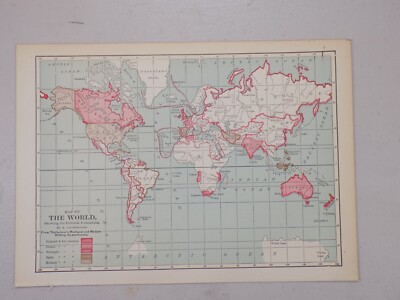
Free Shipping Location: Monroeville, United States Genuine original antique and historical maps. Prints, engravings and illustrated books Antique& old vintage pictures prints& maps from POSTAPRINT: ... moreTopography. Good town views& city plans. Fine art engravings, WORLD 1901: Collectable Antique Map by Longmans Green. Projected on centre of Atlantic + Pacific Ocean, Authentic vintage& antique pictures prints and maps by mail order. There is printing on the back. Item I/D VM-2862 OVERALL SIZE incl. margins: 13.5x10.5 Inches. 34x27 Cms. FOLDING. IMAGE Size Varies: 12x9 Inches. 30x23 Cms All measurements are approximate. VERIFY THE DATE FOR MORE MAPS FROM THIS SERIES THE SCAN BELOW IS AN ENLARGED SECTION AS AN EXAMPLE OF THE DETAIL PROVENANCE THE PUBLIC SCHOOL ATLAS OF MODERN GEOGRAPHY IN 33 MAPS EXHIBITING CLEARLY THE MORE IMPORTANT PHYSICAL FEATURES OF THE COUNTRIES DELINEATED AND NOTING ALL THE CHIEF PLACES OF HISTORICAL. COMMERCIAL OR SIMILAR INTEREST. Edited…by the Rev. George Butler PUBLISHED 1901 BY Longmans Green& Co. 39 Paternoster Row London. New York and Bombay. This was issued as an illustration in the above book. AUTHENTICITY WARRANTED TO BE A GENUINE OLD ITEM. PRINTED AT THE DATE STATED. We NEVER offer modern day copies. The buyer may wish to print this page. CONDITION Good. Suitable for framing. Please see the scan. All old maps and prints are subject to normal ageing which is not obtrusive unless otherwise stated. PAYMENT PAYPAL PREFERRED PLEASE. RETURNS POLICY SATISFACTION GUARANTEED or your money back. Buyer pays return postage. Orders are normally mailed within 1 business day of payment. Except for vacations etc. UK DELIVERY BY 1st CLASS MAIL: Normally 1-2 working days. INTERNATIONAL BY AIR MAIL: Normally 5-10 working days. Please understand we cannot guarantee the efficiency of the Postal Services. Although they are generally reliable. More information WE HAVE BEEN IN BUSINESS FOR OVER 30 YEARS MANY 1000'S OF AUTHENTIC ANTIQUE COLLECTABLE and VINTAGE ITEMS ON OFFER France: Gravures et Cartes anciennes. Deutschland: Alte Lankart
Buy It Now
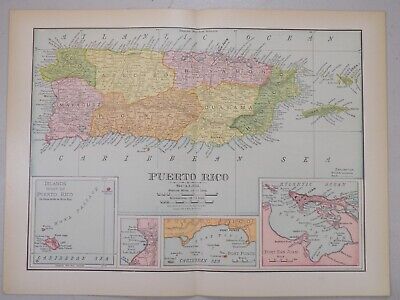
Free Shipping Location: Monroeville, United States Puerto Rico San Juan beautiful 1901 Cram antique folio detailed color map PORTO RICO(with insets of San Juan Harbor& Crab Island) Issued Chicago& ... moreNew York. 1901 by George Cram. Fine original antique offset color lithographed map. Made approximately 110 years ago. Printed in the early 20th century, on quality paper which retains its inherent structural flexibility and soundness. In near VG or better condition. Some very gentle toning to edges which is hardly offensive[note: we grade very conservatively and always seek to disclose any noteworthy flaws] The printed area remains visually pleasing. A nice impression of an interesting and amazingly detailed map. Sheet measures c. 22 1/4" W x 14 1/2" H. Printed area measures c. 20" W x 13 1/2" H. Folio. Original fold line as issued. 13537] Any defects along the sheet edges and in the margins may be seen in the photos. note: All old sheets of printed paper possibly have short edge splits. Each sheet has existed for a very long time and has probably been handled repeatedly in the course of it's existence. It has a history unique to it as an object. Most of the time any edge splits are short. Minor, insignificant and have been closed- either long ago or more recently with small pieces of archival tape. Most often these splits are trivial and easy to overlook visually. Basically, they would not significantly affect the piece adversely. The item is offered as seen. Please look carefully and make your decision knowing this antique image is nice. But it is not in perfect"like new" condition. However, with whatever flaws it possesses, it remains entirely worthy of ownership and inclusion in any related collection. We feel it will prove very pleasing to its new owner. We stand behind everything we sell. Everything we offer is guaranteed to be an authentic original antique item as described. We do not sell modern reproductions. Please visit our. We happily accept PayPal!
Buy It Now
Free Shipping Location: Monroeville, United States Date - 1901. Condition - Very Nice.
Buy It Now
Free Shipping Location: Monroeville, United States Date - 1901. Condition - Very Nice.

Buy It Now
Free Shipping Location: Monroeville, United States Philippine Islands 1901 Rand McNally massive antique folio map Philippine Islands Issued 1901. Chicago. Published by Rand McNally and Co. Massive early ... more20th century offset color printed map. With detailed insets of Manila city. Batanes& Babuyanes Islands, Sulu Archipelago, and region of Manila to Dagupan. A monumental early 20th century map of this country. With hundreds of place names not typically found on smaller maps and a level of detail approaching wall map. In VG+ clean fine condition. Will look very nice for display. Once framed a huge map. Not to be confused with the much more common small quarto format issues of similar titled maps. This map is close to wall sized if framed. Sheet size measures c. 20 1/2" W x 28" H. Engraved area c. 18 1/2" W x 26 5/8" H. 7392] Any defects along the sheet edges and in the margins may be seen in the photos. note: All old sheets of printed paper possibly have short edge splits. Each sheet has existed for a very long time and has probably been handled repeatedly in the course of it's existence. It has a history unique to it as an object. Most of the time any edge splits are short. Minor, insignificant and have been closed- either long ago or more recently with small pieces of archival tape. Most often these splits are trivial and easy to overlook visually. Basically, they would not significantly affect the piece adversely. The item is offered as seen. Please look carefully and make your decision knowing this antique image is nice. But it is not in perfect"like new" condition. However, with whatever flaws it possesses, it remains entirely worthy of ownership and inclusion in any related collection. We feel it will prove very pleasing to its new owner. We stand behind everything we sell. Everything we offer is guaranteed to be an authentic original antique item as described. We do not sell modern reproductions. Please visit our. We happily accept PayPal! WE OFFER FLAT

Buy It Now
Free Shipping Location: Monroeville, United States i000000. 1901 ANCIENT EGYPT THEBEN Antique Map Click to Enlarge Click to Enlarge Original old German map(printed on the both sides)book plate(not a modern ... morereproduction)comes from a German lexicon. The map has been printed by Bibliographisches Institut.Leipzig,Germany in 1901. It looks great when framed. The overall size of this print with margins approx 9 1/2" x 6 1/2" Usually I show on the picture that area of print which will be visible in the frame. Condition can be see from the scan. PLEASE NOTE! FOR MULTIPLE BUYERS. All combined items must be paid once a week. If the items are not paid in a 2 week(14 days) now the eBay assistant will automatically open a case for unpaid item. After reading all of auction. Please ask any and all questions BEFORE bidding! Thank You If you have questions or problems before OR after you receive an item. PLEASE contact us ASAP. We leave feedback for everyone. Once transaction is complete and feedback has been left for us. We believe in and encourage good communication! We work hard to keep our customers happy! We accept returns ONLY if there is a problem(or damage) on the item. Multiple winner safe shipping cost. Shipping is same for 1-3 prints Please allow approximately two-three weeks for delivery from Europe after payment received. Payment must be received up to 7 days. Payment by PayPal. SORRY but we do not accept eChecks. DO NOT DUPLICATE OR COPY! Template Made By: © Inkfrog Template Center Auction Templates. Logos, Store fronts and more! inkfrog terapeak. ``d.RcmdId ViewItemDescV4,RlogId p4%60bo7%60jtb9%3Fvo%7B%3Dd70f%2B%3E%60%60d-14047bbce3a-0x109-

Buy It Now
Free Shipping Location: Monroeville, United States Advance British Army Pretoria S Africa 1901 antique color type Transvaal War map Map Showing the Lines of Advance from Bloemfontein to Pretoria Issued ... more1901. London Printed by T.C. E. C. Jack. Edinburgh Fine original antique color type map. Printed on quality paper which retains its inherent structural flexibility and soundness. Scarce map. Overprinted in red to show movements of troops, military positions, etc. In near VG or better condition. Light minor age wear but the image is clean and very attractive[note: we grade very conservatively and always seek to disclose any noteworthy flaws] The printed area remains visually pleasing. A nice impression of an interesting image. Any minor defects along the sheet edges and in the margins may be seen in the photos. Sheet measures c. 6 5/8" W x 8 1/2" H. Engraved area measures c. 5 3/8" W x 6 3/4" H. 38025] note: All old sheets of printed paper possibly have short edge splits. Each sheet has existed for a very long time and has probably been handled repeatedly in the course of it's existence. It has a history unique to it as an object. Most of the time any edge splits are short. Minor, insignificant and have been closed- either long ago or more recently with small pieces of archival tape. Most often these splits are trivial and easy to overlook visually. Basically, they would not significantly affect the piece adversely. The item is offered as seen. Please look carefully and make your decision knowing this antique image is nice. But it is not in perfect"like new" condition. However, with whatever flaws it possesses, it remains entirely worthy of ownership and inclusion in any related collection. We feel it will prove very pleasing to its new owner. We stand behind everything we sell. Everything we offer is guaranteed to be an authentic original antique item as described. We do not sell modern reproductions. Please visit our eBay Store. We happily accept PayPal! W
Buy It Now
Free Shipping Location: Monroeville, United States Date - 1901. Condition - Very Nice.
Buy It Now
Free Shipping Location: Monroeville, United States Date - 1901. Condition - Very Nice.
Buy It Now
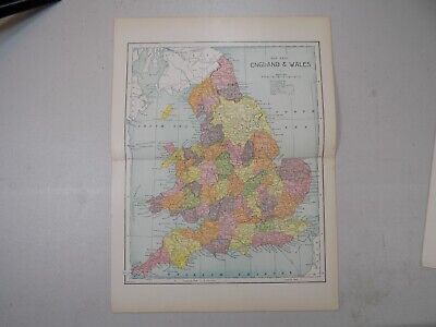
Free Shipping Location: Monroeville, United States Genuine original antique and historical maps. Prints, engravings and illustrated books Antique& old vintage pictures prints& maps from POSTAPRINT: ... moreTopography. Good town views& city plans. Fine art engravings, ENGLAND and WALES 1901: Collectable Antique Map by Longmans Green, Authentic vintage& antique pictures prints and maps by mail order. There is printing on the back. Item I/D VM-2867 OVERALL SIZE incl. margins: 13.5x10.5 Inches. 34x27 Cms. FOLDING. IMAGE Size Varies: 12x9 Inches. 30x23 Cms All measurements are approximate. VERIFY THE DATE FOR MORE MAPS FROM THIS SERIES THE SCAN BELOW IS AN ENLARGED SECTION AS AN EXAMPLE OF THE DETAIL PROVENANCE THE PUBLIC SCHOOL ATLAS OF MODERN GEOGRAPHY IN 33 MAPS EXHIBITING CLEARLY THE MORE IMPORTANT PHYSICAL FEATURES OF THE COUNTRIES DELINEATED AND NOTING ALL THE CHIEF PLACES OF HISTORICAL. COMMERCIAL OR SIMILAR INTEREST. Edited…by the Rev. George Butler PUBLISHED 1901 BY Longmans Green& Co. 39 Paternoster Row London. New York and Bombay. This was issued as an illustration in the above book. AUTHENTICITY WARRANTED TO BE A GENUINE OLD ITEM. PRINTED AT THE DATE STATED. We NEVER offer modern day copies. The buyer may wish to print this page. CONDITION Good. Suitable for framing. Please see the scan. All old maps and prints are subject to normal ageing which is not obtrusive unless otherwise stated. PAYMENT PAYPAL PREFERRED PLEASE. RETURNS POLICY SATISFACTION GUARANTEED or your money back. Buyer pays return postage. Orders are normally mailed within 1 business day of payment. Except for vacations etc. UK DELIVERY BY 1st CLASS MAIL: Normally 1-2 working days. INTERNATIONAL BY AIR MAIL: Normally 5-10 working days. Please understand we cannot guarantee the efficiency of the Postal Services. Although they are generally reliable. More information WE HAVE BEEN IN BUSINESS FOR OVER 30 YEARS MANY 1000'S OF AUTHENTIC ANTIQUE COLLECTABLE and VINTAGE ITEMS ON OFFER France: Gravures et Cartes anciennes. Deutschland: Alte Lankarten und Stadt ansichten. Italia: Stamp
Buy It Now
$7.00 Shipping Location: North Wales, United States 1901 ANTIQUE CRAM ATLAS MAP-ALASKA-EXCELLENT DETAIL ORIGINAL ATLAS MAP PLEASE SEE PHOTOS AS PART OF THE DESCRIPTION CONDITION: MAP IS IN GOOD CONDITION. ... moreSIZE: APPROXIMATELY 14" X 22" SHIPPING: U.S. FIRST CLASS RATE - $8.00 - ANY ITEM WHICH SELLS FOR OVER $100 WILL REQUIRE INSURANCE WE COMBINE SHIPPING FOR MULTIPLE WINS. THANK YOU FOR YOUR INTEREST IN OUR AUCTIONS!.
Buy It Now
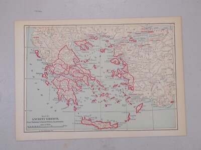
Free Shipping Location: Monroeville, United States You will only pay Post& Packing on the largest print. All other prints purchased at the same time will be Post& Packing FREE You are bidding on ... morea Genuine Original 1901 Antique Map of. Graecia Antiqua from Chambers Encyclopedia A Dictionary Of Universal Knowledge This is a genuine Double Page Map from the Encyclopedia not a copy or reproduction. Published 1901 The Map is in a good condition for it's age of over 110 years. Slightly yellowed consistent with age and has a diaganol fold from approx 3/4 to left side from bottom to approx 1/2 way along bottom line- off of image- Please see Photos for condition. As this is a double page from the book there is a fold line down the centre of the map where it has been bound into a book. The back is plain there is no text on the reverse- Please see photos for condition. Published Williams& Robert Chambers. Limited London And Edinburgh J.B. Lippincott Company. Philadelphia 1901 A rare opportunity to own a Genuine Vintage Map. Great for collectors or historians, would look great mounted and framed. Approx overall Size of page approx 12" x 10.5" Please see my other listings for more Antique Maps& Prints. You will only pay Post& Packing on the largest print. All other prints purchased at the same time will be Post& Packing FREE The Postage Cost is for Standard Airmail only. If you require Tracking& Insurance please add an extra $8.00 Per Package(Except for Asia where tracking is already include in price shown) Sorry but payment from Overseas buyers by Paypal only* Our Ref LEM936 Powered by The free listing tool. List your items fast and easy and manage your active items. RcmdId ViewItemDescV4,RlogId p4%60bo7%60jtb9%3Fuk.rp*3A%3Cd%3Ff6%3E-14480859fc5-0x10b-
Buy It Now
$8.00 Shipping Location: North Wales, United States 1901 ANTIQUE CRAM ATLAS MAP-PENNSYLVANIA-UNITED STATES ORIGINAL ATLAS MAP PLEASE SEE PHOTOS AS PART OF THE DESCRIPTION CONDITION: MAP IS IN GOOD CONDITION. ... moreSIZE: APPROXIMATELY 14" X 22" SHIPPING: U.S. FIRST CLASS RATE - $8.00 - ANY ITEM WHICH SELLS FOR OVER $100 WILL REQUIRE INSURANCE WE COMBINE SHIPPING FOR MULTIPLE WINS. THANK YOU FOR YOUR INTEREST IN OUR AUCTIONS!.

Buy It Now
$8.30 Shipping Location: Celina, United States Antique Atlas 1901 Twentieth Century Peerless Atlas of the World Fold Out maps Click to Enlarge Click to Enlarge Click to Enlarge Click to Enlarge Click ... moreto Enlarge Click to Enlarge Click to Enlarge Click to Enlarge Thank you for viewing my listing. Antique Atlas. 1901, Twentieth Century Peerless Atlas of the World, It is complete, with all Fold Out maps and regular maps, really in nice shape, all maps are great without issues, some stains on cover, Cover is a Semi hard cover Flexi cover PLEASE READ ALL THE BORING DETAILS Please make sure you understand what you are buying. I try to take detailed photos. If you have questions or concerns regarding this item please address them before placing bid. I do not mind answering questions. Really! If you purchase more then one item. I do combine on shipping- but PLEASE wait for me to invoice you and make the adjustment on your invoice. If you purchase just one item, no need to wait for me, pay anytime. I am a very fast shipper, please do not base my performance on the time it takes the post office to deliver your package This is my business.And it has been for nearly 3 decades. It is not a hobby for me and I take it seriously. I treat all my customers with the respect they deserve. For my*INTERNATIONAL CUSTOMERS* 1.Import duties. Taxes, and charges are NOT INCLUDED in the item price or shipping charges. These charges are the buyer’s responsibility. 2.Please check with your country’s customs office to determine what these additional costs will be prior to bidding/ buying. These charges are normally collected by the delivering freight(shipping) company or when you pick the item up– do not confuse them for additional shipping charges 3. We do not. And will not mark merchandise values below actual value or mark items as"gifts" US and International government regulations prohibit such behavior. For more info. visit this site http:www.wcoomd.org/tariff/ MARYLAND BUYERS WILL HAVE TO PAY MARYLAND SALES TAX I strive to earn 5 Stars on all my tr
Buy It Now
$4.00 Shipping Location: Harborton, United States ANTIQUE COLLECTIBLE MAP OF YELLOWSTONE NATIONAL PARK IN WYOMING. This is an antique map which was carefully removed from a George Cram atlas.
Buy It Now
$4.00 Shipping Location: Harborton, United States It is dated 1901 on the bottom right corner. It is in very good condition - note there is another map on the reverse side.

Buy It Now
Free Shipping Location: Monroeville, United States Welcome to Art2Love1! Best Customer Service. Faster Shipment, Honest Description and Commitment to Excellence Since 2005! ~~~DESCRIPTION~~ WE EXPECT PAYMENT ... moreWITHIN 24 HOURS OF PURCHASE. WE SHIP WITHIN A DAY! Thank you for visiting us. 1901 C.S. HAMMOND& CO NY MAP OF EUROPE 11 BY 9" THIN PAPER BOND BLANK BACK ONE INCH SLIT IN THE FOLD LINE ON BOTTOM- EASILY REINFORCED. MINT OTHERWISE. WE ARE LISTING ABOUT 50 OTHER ANTIQUE MAPS. WE COMBINE SHIPPING. Check out my other items! Please read our Terms& Conditions First: Your Bid is a Contract 1. Please note that we issue no refunds or returns on our vintage items. 2. Our shipping rates are estimates for shipping items with tracking and insurance whenever possible. Our shipping quotes include a small handling charge. We always strive to ship our items within a day of your payment. 3. If you need more information and pictures. Write to us and we will respond within a day. 4. We expect you to pay for your item within 24 hours of receiving our invoice on PayPal. 5. If you wish to process another form of payment(we accept Certified Checks) advise us within 24 hours of winning a bid. All our sales are final. 6. Our descriptions reflect our personal and honest estimate and idea of the items we list: we do our research but are not experts in every area. If you need to clarify information we provide. Do so before bidding. 7. We expect you to communicate with us if there is a gross problem with the item you receive. And leave your positive feedback. In exceptional cases only, we will consider accepting item back, but you must incur shipping charges back to us and a 20% restocking fee. 8. We are not responsible for any duty or customs fees and the like in your destination. Those expenses are to be wholly and solely borne by each buyer. We do. However, provide proper shipping information, with your winning bid as the value of each object. 9. IF YOU WISH TO BUY SEVERAL ITEMS AT ONCE. WE WILL ALWAYS AND GLADLY COMBINE SHIPPING. Powered by Powered by
Buy It Now
$6.00 Shipping Location: North Wales, United States 1901 ANTIQUE POATES ATLAS MAP-AUSTRO-HUNGARIAN MONARCHY-AUSTRIA-HUNGARY ORIGINAL ANTIQUE ATLAS MAP PLEASE SEE PHOTOS AS PART OF THE DESCRIPTION CONDITION: ... moreMAP IS IN GOOD CONDITION. FOXING PRESENT. SIZE: APPROXIMATELY 6" X 6.5" SHIPPING: U.S. FIRST CLASS RATE - $6.00 - ANY ITEM WHICH SELLS FOR OVER $100 WILL REQUIRE INSURANCE WE COMBINE SHIPPING FOR MULTIPLE WINS. THANK YOU FOR YOUR INTEREST IN OUR AUCTIONS!.

Buy It Now
Free Shipping Location: Monroeville, United States Genuine original antique and historical maps. Prints, engravings and illustrated books Antique& old vintage pictures prints& maps from POSTAPRINT: ... moreTopography. Good town views& city plans. Fine art engravings, NORTH AMERICA USA + Canada Etc. 1901: Collectable Antique Map by Longmans Green. Authentic vintage& antique pictures prints and maps by mail order. There is printing on the back. Item I/D VM-2865 OVERALL SIZE incl. margins: 13.5x10.5 Inches. 34x27 Cms. FOLDING. IMAGE Size Varies: 12x9 Inches. 30x23 Cms All measurements are approximate. VERIFY THE DATE FOR MORE MAPS FROM THIS SERIES THE SCAN BELOW IS AN ENLARGED SECTION AS AN EXAMPLE OF THE DETAIL PROVENANCE THE PUBLIC SCHOOL ATLAS OF MODERN GEOGRAPHY IN 33 MAPS EXHIBITING CLEARLY THE MORE IMPORTANT PHYSICAL FEATURES OF THE COUNTRIES DELINEATED AND NOTING ALL THE CHIEF PLACES OF HISTORICAL. COMMERCIAL OR SIMILAR INTEREST. Edited…by the Rev. George Butler PUBLISHED 1901 BY Longmans Green& Co. 39 Paternoster Row London. New York and Bombay. This was issued as an illustration in the above book. AUTHENTICITY WARRANTED TO BE A GENUINE OLD ITEM. PRINTED AT THE DATE STATED. We NEVER offer modern day copies. The buyer may wish to print this page. CONDITION Good. Suitable for framing. Please see the scan. All old maps and prints are subject to normal ageing which is not obtrusive unless otherwise stated. PAYMENT PAYPAL PREFERRED PLEASE. RETURNS POLICY SATISFACTION GUARANTEED or your money back. Buyer pays return postage. Orders are normally mailed within 1 business day of payment. Except for vacations etc. UK DELIVERY BY 1st CLASS MAIL: Normally 1-2 working days. INTERNATIONAL BY AIR MAIL: Normally 5-10 working days. Please understand we cannot guarantee the efficiency of the Postal Services. Although they are generally reliable. More information WE HAVE BEEN IN BUSINESS FOR OVER 30 YEARS MANY 1000'S OF AUTHENTIC ANTIQUE COLLECTABLE and VINTAGE ITEMS ON OFFER France: Gravures et Cartes anciennes. Deutschland: Alte Lankarten und Stadt ansichten.

Buy It Now
Free Shipping Location: Monroeville, United States 1901 Beautiful Antique Highly Detailed Map of Mexico plus Birdseye View of Maritime Canal of Nicaragua on the back Source: Antique Map. Never a reproduction. ... moreCram's Modern Atlas Publisher: Hudgins Publishing. Atlanta, Georgia Year: 1901 Approximate size: Single Folded Page 14.5" X 22" Images slightly smaller with Printed Border Condition: Original Antique Map. Condition is Excellent within the image, edges have light toning, occasional foxing spots, most maps still have the paper hinge attached on the back, and a fox spot at bottom left margin, just into the border, otherwise no issues. These pictures are the actual maps About Condition: Having grown up in the antique business. Back in the day we used words like patina, aged and original to describe beautiful things that had some wear. Today we use words like, rugged, shabby chic and re-purposed. These maps fall into those categories. The images are well produced, great strong colors and excellent materials. The margins may have small edge tears, occasional foxing or tanning. These flaws could be damage or patina. Please look closely at the images and make your own call. If the maps look damaged, then they are probably are not for you, if however you see the beautiful image framed and hung in a favorite place then they are right up your alley. if you need help ask questions and I will get back to you quickly, better to ask before you purchase than to create any stress later on. Shipping $3.50 USA. $5 Canada, and $6.50 Worldwide. Images will be shipped with cardboard backing and celowrap to help protect them from damage. Check my feedback. My customers are happy! I gladly combine shipping on multiple purchases. 1901crams03262012 This is how the Atlas looked when I bought it!
Buy It Now
$4.00 Shipping Location: Harborton, United States This is an original, not reproduction, antique map which was carefully removed from a Rand McNally atlas published in 1903. The map is dated 1901 on the ... morebottom edge below the title. There is another map on the reverse side.
Buy It Now
Free Shipping Location: Monroeville, United States RareVintage 1901 Big Wall Map New York City& Vicinity Large 36" x 50" US Geologic Survey Includes: Includes all boroughs and parts of New ... moreJersey and Connecticut. DESCRIPTION: A big. Beautiful, detailed antique wall map for framing and hanging in your New York City, New Jersey, or Connecticut home. Great conversation piece! Map reveals in detail contour lines of elevation on land and depths on the water. It also shows all landmarks. Buildings, lighthouses, roads, railroads, and sea routes. Dated 1901, and reprinted in 1915. CONDITION: Please see photographs. Overall it is in very good viewing condition. Edges are rough with some tears. But with a matt the damage would be invisible. LOW OPENING BID& NO RESERVE
Buy It Now
Free Shipping Location: Augusta, United States This 14 1/2" x 22" map is in VERY GOOD+ condition with light tone, soil, and a fold in the middle as issued, from a disbound George Cram atlas ©1901. ... more"An Authentic Original Map Not A Reproduction".
Buy It Now
Free Shipping Location: Monroeville, United States Date - 1901. Condition - Very Nice.
Buy It Now
Free Shipping Location: Augusta, United States "An Authentic Original Map Not A Reproduction".
Buy It Now
Free Shipping Location: Willow Grove, United States This is an ORIGINAL Nevada map taken from a 1901 atlas. There is text on the reverse side of this map page.
Buy It Now
Free Shipping Location: Monroeville, United States ANTIQUE GLASGOW and DUNDEE SCOTLAND COLLECTIBLE MAP This is an original. Not reproduction, vintage map which was carefully removed from an atlas. Item ... moremeasures approximately 8.5" by 12" and is in very good condition. I happily combine purchases to save on shipping fees. Your item will be packaged in a plastic sleeve. And shipped in a cardboard mailing tube. Please email with questions. I will answer your email promptly! Be sure to add me to your! Check out my! Powered by The free listing tool. List your items fast and easy and manage your active items.

Buy It Now
$5.00 Shipping Location: Canada 1901 PHYSICAL MAP OF EUROPE RIVERS MOUNTAINS MEDITERRANEAN SEA RUSSIA TURKEY This original antique map gives you an opportunity to examine in exquisite ... moredetail a piece of history. If you are interested in the past of this country and its people or have a desire to study where your family may have come from. Then this map gives you a rare look as the area was about 110 years ago. Once matted and framed, this map would make a perfect gift for a family member or friend they'll cherish forever. Origin of the map: Richters Atlas fuer Hoehere Schulen" by Otto Richter and Constantin Schulteis. Published by Carl Flemming Verlag, Glogau, Germany. Date of issue: 1901 Size: The sheet measures 14 3/4" x 11 1/2" 37 x 29 cm) S/H: The map will be shipped by Air Mail. The shipping charge is: USA- 8.00 USD/ Canada- 9.00 USD/ World- 9.00 USD. The price includes a strong. Secure tube with plastic plugs. Attention! There is no additional shipping charge for multiple purchases! Pay me securely with any major credit card through PayPal! Payment methods: US/Canada Buyers: Paypal. International Buyers: Paypal. Click Here. Double your traffic. Get Vendio Gallery- Now FREE! G6.RcmdId ViewItemDescV4,RlogId p4%60bo7%60jtb9%3Fuk%601d72f%2B%3Eg6%3E-14876072fdb-0x111-
Buy It Now
$4.00 Shipping Location: Harborton, United States This is an original, not reproduction, antique map which was carefully removed from a Rand McNally atlas published in 1902. It is dated 1901 on the bottom ... moreedge. It is in very good condition - note light creasing and there is another map on the reverse side.
Buy It Now
$4.00 Shipping Location: Harborton, United States ANTIQUE ORIGINAL MAINE STATE MAP. It is in very good condition - note light creasing, text on the reverse side, and it is a centerfold as issued.
Buy It Now
$4.00 Shipping Location: Harborton, United States This is an original, not reproduction, antique Buffalo map which was carefully removed from a George Cram atlas.
Buy It Now
$4.00 Shipping Location: Harborton, United States This is an antique Duluth city map which was carefully removed from a George Cram atlas. ANTIQUE COLLECTIBLE MAP OF DULUTH MINNESOTA. The map is in very ... moregood condition.
Buy It Now
Free Shipping Location: Monroeville, United States Date - 1901. Condition - Very Nice.
Buy It Now
Free Shipping Location: Monroeville, United States Date - 1901. Condition - Very Nice.
Buy It Now
Free Shipping Location: Augusta, United States This 14 1/2" x 11" map is in VERY GOOD+ condition with very light tone, soil and two black spots from publishing as seen in the last photo, from a disbound ... moreGeorge Cram atlas ©1901. "An Authentic Original Map Not A Reproduction".
Buy It Now
$6.00 Shipping Location: North Wales, United States 1901 ANTIQUE POATES ATLAS MAP-AUSTRALIA-NEW ZEALAND-POLYNESIAN ISLANDS ORIGINAL ANTIQUE ATLAS MAP PLEASE SEE PHOTOS AS PART OF THE DESCRIPTION CONDITION: ... moreMAP IS IN GOOD CONDITION. FOXING PRESENT. SIZE: APPROXIMATELY 6" X 6.5" SHIPPING: U.S. FIRST CLASS RATE - $6.00 - ANY ITEM WHICH SELLS FOR OVER $100 WILL REQUIRE INSURANCE WE COMBINE SHIPPING FOR MULTIPLE WINS. THANK YOU FOR YOUR INTEREST IN OUR AUCTIONS!.
Buy It Now
Free Shipping Location: Monroeville, United States Date - 1901. th Century. Size - about 10.25x13.75", double page as published.
Buy It Now
$4.95 Shipping Location: Willow Grove, United States This is an ORIGINAL Portland Maine map taken from a 1901 atlas. There is a map image and text on the reverse side of this map page.
Buy It Now
$4.00 Shipping Location: Harborton, United States This is an antique map of Brussels which was carefully removed from a George Cram's atlas.
Buy It Now
$4.00 Shipping Location: Harborton, United States Pretty antique Nebraska map which was carefully removed from a George Cram atlas. folded at the middle so it could fit in the atlas. ANTIQUE NEBRASKA ... moreSTATE MAP. It is in very good condition. It is a centerfold map as issued - printed on a large sheet of paper then.
Buy It Now
$4.95 Shipping Location: Willow Grove, United States This is an ORIGINAL 1901 Philippines map taken from a 1902 atlas. There is a map image and text on the reverse side of this map page.

Buy It Now
Free Shipping Location: Monroeville, United States Home ~ Affiliations ~ Discounts ~ FAQs ~ Grading and Certification ~ Premium Shipping ~ About Us VINTAGE ART 1901 Lithograph Antique Map Political South ... moreAmerica Submarine Telegraph Cables Details Year: 1901 Type: Original Lithograph Grade: Near Mint/ Very Fine+ Authentication: Dual Certificates Image: Color Approximate Size(inches) 7 x 9.5 Approximate Size(cm) 18 x 24 Description and Condition This is an original 1901 color lithograph map of South America including Panama. Colombia, Venezuela, Guyana, Ecuador, Peru, Bolivia, Chile, Argentina, Uruguay, Paraguay, and Brazil. The submarine telegraph cables are shown in red lines. CONDITION This 110+ year old Item is rated Near Mint/ Very Fine+. No natural defects.No tears. No water damage. Please note there are several original creases on this print. To find other items from this specific collection in our eBay store. Please. Keywords specific to this image: Atlantic Ocean. Pacific Ocean. XGO8C01 Product Pricing& What We Deliver At times we receive inquiries about our pricing. Especially for vintage advertising or historical halftone prints, and are asked why our prices are consistently higher than some other sellers of similar items. For the first five years of our business, we asked our primary consumer base what they wanted. Our primary consumers- historical societies, historians, archivists, curators, university professors, historical decorators, and collectors, etc. have diverse and specific needs and we've built our business to accommodate those needs, like no other seller worldwide. Below is what is unique about how and what we offer as the world's leader in print ephemera: Product Packaging. Every product is placed against custom black acid-free board with crystal-clear. Archival protective closures. We are the only sellers in the industry who provide display-quality black boards with every item(which also make exceptional presentations for gift-giving) Oversized engravings are protected by museum quality tubes. Product Pictures. Online digital

Buy It Now
Free Shipping Location: Monroeville, United States Hawaii w/ Honolulu city plan inset 1901 Cram antique folio detailed color map HAWAII Issued Chicago& New York. 1901 by George Cram. Fine original ... moreantique offset color lithographed map. Made approximately 110 years ago. Printed in the early 20th century, on quality paper which retains its inherent structural flexibility and soundness. In near VG or better condition. Some very gentle toning to edges which is hardly offensive[note: we grade very conservatively and always seek to disclose any noteworthy flaws] The printed area remains visually pleasing. A nice impression of an interesting and amazingly detailed map. Sheet measures c. 22 1/4" H x 14 1/2" W. Printed area measures c. 17 1/4" H x 11 1/2" W. Folio. Original fold line as issued. 13539] Any defects along the sheet edges and in the margins may be seen in the photos. note: All old sheets of printed paper possibly have short edge splits. Each sheet has existed for a very long time and has probably been handled repeatedly in the course of it's existence. It has a history unique to it as an object. Most of the time any edge splits are short. Minor, insignificant and have been closed- either long ago or more recently with small pieces of archival tape. Most often these splits are trivial and easy to overlook visually. Basically, they would not significantly affect the piece adversely. The item is offered as seen. Please look carefully and make your decision knowing this antique image is nice. But it is not in perfect"like new" condition. However, with whatever flaws it possesses, it remains entirely worthy of ownership and inclusion in any related collection. We feel it will prove very pleasing to its new owner. We stand behind everything we sell. Everything we offer is guaranteed to be an authentic original antique item as described. We do not sell modern reproductions. Please visit our. We happily accept PayPal! WE OFFER FLAT RATE SHIPPING WORLD WIDE! P
Buy It Now
$4.13 Shipping Location: Columbia, United States Original Soil Map dated 1901. Pennsylvania - Lebanon vicinity. ANTIQUE MAP.
Buy It Now
Free Shipping Location: Monroeville, United States Be sure to add me to your! This is an original. Not reproduction, vintage map which was carefully removed from an atlas. Map measures approximately 10 ... morex 13 and is in very good condition. There is surrounding white border if you choose to mat the map. Your item will be packaged in a plastic sleeve. With a thin piece of backing, then in a manila envelope with a very stiff and thick piece of cardboard or in a cardboard mailing tube. We happily combine purchases to save on shipping fees. Please email with questions. We will answer your email promptly! Please visit our ebay store. Plaindealing Vintage Paper. We have stocked it with thousands of vintage advertisements, prints, and historical articles. Check out my! Powered by The free listing tool. List your items fast and easy and manage your active items.
Buy It Now
Free Shipping Location: Monroeville, United States Date - 1901. Condition - Very Nice.
Buy It Now
Free Shipping Location: Willow Grove, United States This is an ORIGINAL North Dakota map taken from a 1901 atlas. On one half of the reverse side of this map page is the index for this North Dakota map.
Buy It Now
$4.95 Shipping Location: Willow Grove, United States This is an ORIGINAL map of Washington DC titled Washington which was taken from a 1901 atlas. There is a map image and text on the reverse side of this ... moremap page.
Free Shipping Location: Marana, United States This Map was removed from a 1901 Atlas and is in good acceptable condition. ~ NATIONAL1901/020821. Including Hundreds of RareCivil War. 110+ years of ... moreaging. Study the photos carefully, this is the actual map you.
Buy It Now
$4.55 Shipping Location: Oakland, United States This antique map of Wyoming from 1901 by Rand, McNally & Co. is a rare find for collectors and enthusiasts alike. Featuring detailed cartography and published ... moreover a century ago, this piece provides a glimpse into the state's history and geography. The map measures 7x6 inches and is in good condition considering its age. Perfect for display or research purposes, this item would make a great addition to any collection of North America maps or antique memorabilia.
Buy It Now
Free Shipping Location: Monroeville, United States Date - 1901. Condition - Very Nice.
Buy It Now
$6.00 Shipping Location: North Wales, United States 1901 ANTIQUE POATES ATLAS MAP-CENTRAL EUROPE-GERMAN EMPIRE & AUSTRIA-HUNGARY ORIGINAL ANTIQUE ATLAS MAP PLEASE SEE PHOTOS AS PART OF THE DESCRIPTION CONDITION: ... moreMAP IS IN GOOD CONDITION. FOXING PRESENT. SIZE: APPROXIMATELY 6" X 6.5" SHIPPING: U.S. FIRST CLASS RATE - $6.00 - ANY ITEM WHICH SELLS FOR OVER $100 WILL REQUIRE INSURANCE WE COMBINE SHIPPING FOR MULTIPLE WINS. THANK YOU FOR YOUR INTEREST IN OUR AUCTIONS!.
Buy It Now
Free Shipping Location: Monroeville, United States Date - 1901. Condition - Very Nice.
Buy It Now
Free Shipping Location: Monroeville, United States This is a Historical treasure. Sketch Map of the Isthmus of Darien and Valley of the Atrato. It was done by Commodore Selfridge of the US Navy in 1901. ... moreIt shows Panama along with the Caribbean and Pacific Ocean. Selfridges travels are in red. It is 30" by 25" It is lovely and would be nice professionally mounted and framed. There are tears on some of the folds though. The bottom fold is nearly detached. There are also tears at the top and two on fold 2 near the top. All should be shown in the pictures. Posted with

Buy It Now
Free Shipping Location: Monroeville, United States Genuine original antique and historical maps. Prints, engravings and illustrated books Antique& old vintage pictures prints& maps from POSTAPRINT: ... moreTopography. Good town views& city plans. Fine art engravings, IRELAND 1901: Collectable Antique Map by Longmans Green, Authentic vintage& antique pictures prints and maps by mail order. There is printing on the back. Item I/D VM-2869 OVERALL SIZE incl. margins: 13.5x10.5 Inches. 34x27 Cms. FOLDING. IMAGE Size Varies: 12x9 Inches. 30x23 Cms All measurements are approximate. VERIFY THE DATE FOR MORE MAPS FROM THIS SERIES THE SCAN BELOW IS AN ENLARGED SECTION AS AN EXAMPLE OF THE DETAIL PROVENANCE THE PUBLIC SCHOOL ATLAS OF MODERN GEOGRAPHY IN 33 MAPS EXHIBITING CLEARLY THE MORE IMPORTANT PHYSICAL FEATURES OF THE COUNTRIES DELINEATED AND NOTING ALL THE CHIEF PLACES OF HISTORICAL. COMMERCIAL OR SIMILAR INTEREST. Edited…by the Rev. George Butler PUBLISHED 1901 BY Longmans Green& Co. 39 Paternoster Row London. New York and Bombay. This was issued as an illustration in the above book. AUTHENTICITY WARRANTED TO BE A GENUINE OLD ITEM. PRINTED AT THE DATE STATED. We NEVER offer modern day copies. The buyer may wish to print this page. CONDITION Good. Suitable for framing. Please see the scan. All old maps and prints are subject to normal ageing which is not obtrusive unless otherwise stated. PAYMENT PAYPAL PREFERRED PLEASE. RETURNS POLICY SATISFACTION GUARANTEED or your money back. Buyer pays return postage. Orders are normally mailed within 1 business day of payment. Except for vacations etc. UK DELIVERY BY 1st CLASS MAIL: Normally 1-2 working days. INTERNATIONAL BY AIR MAIL: Normally 5-10 working days. Please understand we cannot guarantee the efficiency of the Postal Services. Although they are generally reliable. More information WE HAVE BEEN IN BUSINESS FOR OVER 30 YEARS MANY 1000'S OF AUTHENTIC ANTIQUE COLLECTABLE and VINTAGE ITEMS ON OFFER France: Gravures et Cartes anciennes. Deutschland: Alte Lankarten und Stadt ansichten. Italia: Stampe& Map
Buy It Now
Free Shipping Location: Augusta, United States "An Authentic Original Map Not A Reproduction".

Buy It Now
Free Shipping Location: Monroeville, United States SquareTrade © AP6.0 This is a genuine Antique Map ASIA DATE PRINTED: c.1901 PUBLISHERS: George F Cram of 61-63 Plymouth Place Chicago and 130 Fulton ... moreStreet. New York. IMAGE SIZE: 18x12 inches(46x30 cms) approx. OVERALL SIZE: 22x14 inches approx(Double Page folding) CONDITION: Good. Original Color(Colour) REMARKS: Large. Amazingly detailed& attractive map. Printed verso: Single Page Maps of AUSTRIA- HUNGARY AND ITALY. No show through. Scans of either of these provided on request) THE MAP IS MUCH TOO LARGE TO SCAN THE WHOLE IMAGE AREA. ONLY A VERY SMALL SECTION IS SHOWN AUTHENTICITY& WARRANTY: This is a genuine original. Historical antiquarian map/plan/engraving, warranted to have been published at the date stated above. It is NOT a modern copy. We never offer modern reproductions. Postaprint has been selling maps& prints by mail order for over 25 years and on eBay since 1998. RETURNS POLICY: YOUR COMPLETE SATISFACTION IS GUARANTEED! No Questions returns Policy! You simply pay return shipping and mail back in original condition. Suitably packed& insured, within 7 days of receipt. PAYMENT: PREFERRED METHOD: PayPal please. Orders normally mailed within 1 business day of payment. Apart from vacations etc. UK: 1st Class Mail: Delivery normally 1-2 working days. INTERNATIONAL: Air Mail: Delivery usually 5-10 working days. I am sure. However, you will understand I cannot guarantee the efficiency of the Postal Services. Larger parcels. Vacation period deliveries etc, may take longer. FedEx/ courier services available at cost. Many t hanks for looking at this. My name is Julie. Retired after a career in education in England. I so enjoy my hobby of offering antique prints& vintage maps on eBay. That I am extending my eBay store and look forward to making even more new friends. Offers include engravings reflecting Victorian England along with views of the world. Decorative maps, antiquarian and historical plate/ view books and old atlases. Be sure to add me to your favorites list! CLICK HERE To see o
Buy It Now
Free Shipping Location: Augusta, United States This 11" x 14 1/2" map is in GOOD condition with light tone, soil and edge wear, from a disbound Cram's atlas ©1901. "An Authentic Original Map Not A ... moreReproduction".
Buy It Now
$4.00 Shipping Location: Harborton, United States It is in very good condition - note binding hinge paper adhered to the right edge. There is another map on the reverse side.
Buy It Now
$4.00 Shipping Location: Harborton, United States
|
|
|
In
|
Arizona w/ railroad lines overprinted 1901 Rand McNally massive antique map
Arizona w/ railroad lines overprinted 1901 Rand McNally massive antique map Arizona Issued 1901. Chicago. Published by Rand McNally and Co. Massive early 20th century offset color printed map. Overprinted in red to show a profusion of railroad lines then in existence across the state. A monumental early 20th century map of this state. With hundreds of place names not typically found on smaller maps and a level of detail approaching wall map. In VG+ clean fine condition. Will look very nice for display. Once framed a huge map. Not to be confused with the much more common small quarto format issues of similar titled maps. This map is close to wall sized if framed. Sheet size measures c. 14" W x 20 1/2" H. Engraved area c. 12 3/8" W x 18 1/2" H. 7400] Any defects along the sheet edges and in the margins may be seen in the ... morephotos. note: All old sheets of printed paper possibly have short edge splits. Each sheet has existed for a very long time and has probably been handled repeatedly in the course of it's existence. It has a history unique to it as an object. Most of the time any edge splits are short. Minor, insignificant and have been closed- either long ago or more recently with small pieces of archival tape. Most often these splits are trivial and easy to overlook visually. Basically, they would not significantly affect the piece adversely. The item is offered as seen. Please look carefully and make your decision knowing this antique image is nice. But it is not in perfect"like new" condition. However, with whatever flaws it possesses, it remains entirely worthy of ownership and inclusion in any related collection. We feel it will prove very pleasing to its new owner. We stand behind everything we sell. Everything we offer is guaranteed to be an authentic original antique item as described. We do not sell modern reproductions. Please visit our. We happily accept PayPal! WE OFFER FLAT RATE SHIPPING WORLD WIDE
|
|
|
Utah w/ railroad lines overprinted 1901 Rand McNally massive antique folio map
Utah w/ railroad lines overprinted 1901 Rand McNally massive antique folio map Utah Issued 1901. Chicago. Published by Rand McNally and Co. Massive early 20th century offset color printed map. Overprinted in red to show a profusion of railroad lines then in existence across the state. A monumental early 20th century map of this state. With hundreds of place names not typically found on smaller maps and a level of detail approaching wall map. In VG+ clean fine condition. Will look very nice for display. Once framed a huge map. Not to be confused with the much more common small quarto format issues of similar titled maps. This map is close to wall sized if framed. Sheet size measures c. 14" W x 20 1/2" H. Engraved area c. 12 3/8" W x 18 1/2" H. 7395] Any defects along the sheet edges and in the margins may be seen in the ... morephotos. note: All old sheets of printed paper possibly have short edge splits. Each sheet has existed for a very long time and has probably been handled repeatedly in the course of it's existence. It has a history unique to it as an object. Most of the time any edge splits are short. Minor, insignificant and have been closed- either long ago or more recently with small pieces of archival tape. Most often these splits are trivial and easy to overlook visually. Basically, they would not significantly affect the piece adversely. The item is offered as seen. Please look carefully and make your decision knowing this antique image is nice. But it is not in perfect"like new" condition. However, with whatever flaws it possesses, it remains entirely worthy of ownership and inclusion in any related collection. We feel it will prove very pleasing to its new owner. We stand behind everything we sell. Everything we offer is guaranteed to be an authentic original antique item as described. We do not sell modern reproductions. Please visit our. We happily accept PayPal! WE OFFER FLAT RATE SHIPPING WORLD WIDE
|
|
|
San Joaquin Valley CA 1901 scarce original antique color lithograph railroad map
SAN FRANCISCO AND SAN JOAQUIN VALLEY RAILROAD issued Chicago: 1901 Fine original antique color lithograph railroad map. Printed on quality paper which retains its inherent structural flexibility and soundness. A very scarce example of this map. Shows railroad route stops from San Francisco to Caliente California. In Very Good or better condition. Image area is clean, crisp and appealing[note: we grade very conservatively and always seek to disclose any noteworthy flaws] Original center fold line as issued. The printed area remains pleasing. A nice impression that would look great framed. Sheet measures c. 6 5/8" W x 9 1/8" H. Engraved area measures c. 6 1/4" W x 8 5/8" H. E491] Guaranteed Authentic! We do not sell modern reproductions. Condition All of our items are original antique pieces and it is important to keep in ... moremind that many of them have been around for 100 years or more. Individual pieces may have seen many owners and been handled many times over the course of their existence and as a result each piece has developed a history of it's own. Short edge splits(often repaired with archival tape) Foxing, discoloration, etc. are all things to expect on items of this type. They rarely distract from the piece and often add to the overall character of the item. Keep in mind when you receive your item that you are not handling a modern copy, you are holding a piece of history, an item that has been around for a very long time and will, with proper care, be around for a long time to come. We try to note any significant flaws in the description, but less noticeable or common characteristics may not be mentioned. As we are a US based company all of our measurements are in Inches. If you need the size in Centimeters please multiply the supplied measurement by 2.53. Payment and Shipping We happily accept PayPal! Payment is appreciated within 5 days of invoicing. Once payment has been received we do our best to make sure all orders are shipped within two business days and often have them shipped
|
|
|
Sante Fe Railroad entire route 1901 scarce original antique color lithograph map
THE SANTE FE ROUTE TO CALIFORNIA(Sante Fe Railroad- Chicago to San Francisco) issued Chicago: 1901 Fine original antique color lithograph railroad map. Printed on quality paper which retains its inherent structural flexibility and soundness. A very scarce example of this map. Shows entire route and spurs with all the stops. In Very Good or better condition. Image area is clean, crisp and appealing[note: we grade very conservatively and always seek to disclose any noteworthy flaws] Original center fold line as issued. The printed area remains pleasing. A nice impression that would look great framed. Sheet measures c. 9 1/8" W x 6 5/8" H. Engraved area measures c. 8 5/8" W x 6 1/4" H. E492] Guaranteed Authentic! We do not sell modern reproductions. Condition All of our items are original antique pieces and it is important ... moreto keep in mind that many of them have been around for 100 years or more. Individual pieces may have seen many owners and been handled many times over the course of their existence and as a result each piece has developed a history of it's own. Short edge splits(often repaired with archival tape) Foxing, discoloration, etc. are all things to expect on items of this type. They rarely distract from the piece and often add to the overall character of the item. Keep in mind when you receive your item that you are not handling a modern copy, you are holding a piece of history, an item that has been around for a very long time and will, with proper care, be around for a long time to come. We try to note any significant flaws in the description, but less noticeable or common characteristics may not be mentioned. As we are a US based company all of our measurements are in Inches. If you need the size in Centimeters please multiply the supplied measurement by 2.53. Payment and Shipping We happily accept PayPal! Payment is appreciated within 5 days of invoicing. Once payment has been received we do our best to make sure all orders are shipped within two business days and often have t
|
|
|
San Francisco Bay CA 1901 scarce original antique color lithograph railroad map
SAN FRANCISCO BAY AND VICINITY(Santa Fe Railroad) issued Chicago: 1901 Fine original antique color lithograph railroad map. Printed on quality paper which retains its inherent structural flexibility and soundness. A very scarce example of this map. Shows railroad route stops from San Francisco to Cornwall California. In Very Good or better condition. Image is clean, crisp and appealing[note: we grade very conservatively and always seek to disclose any noteworthy flaws] Original center fold line as issued. The printed area remains pleasing. A nice impression that would look great framed. Sheet measures c. 6 5/8" W x 9 1/8" H. Engraved area measures c. 6 1/4" W x 8 5/8" H. E490] Guaranteed Authentic! We do not sell modern reproductions. Condition All of our items are original antique pieces and it is important to keep in ... moremind that many of them have been around for 100 years or more. Individual pieces may have seen many owners and been handled many times over the course of their existence and as a result each piece has developed a history of it's own. Short edge splits(often repaired with archival tape) Foxing, discoloration, etc. are all things to expect on items of this type. They rarely distract from the piece and often add to the overall character of the item. Keep in mind when you receive your item that you are not handling a modern copy, you are holding a piece of history, an item that has been around for a very long time and will, with proper care, be around for a long time to come. We try to note any significant flaws in the description, but less noticeable or common characteristics may not be mentioned. As we are a US based company all of our measurements are in Inches. If you need the size in Centimeters please multiply the supplied measurement by 2.53. Payment and Shipping We happily accept PayPal! Payment is appreciated within 5 days of invoicing. Once payment has been received we do our best to make sure all orders are shipped within two business days and often have them shipped
|
|
|
1901 Antique COLORADO MAP Vintage State Map 1900s Collectible Atlas Map
ANTIQUE COLORADO STATE MAP This is an original. Not reproduction, vintage map which was carefully removed from an atlas. Item measures approximately 20" by 13" and is in very good condition. Map is a centerfold as issued. I happily combine purchases to save on shipping fees. Your item will be packaged in a plastic sleeve. And shipped in a cardboard mailing tube. Please email with questions. I will answer your email promptly! Be sure to add me to your! Check out my! Powered by The free listing tool. List your items fast and easy and manage your active items.
|
|
|
1901 Antique DENVER Colorado Map Vintage Map 1900s Collectible Atlas Map
ANTIQUE DENVER COLORADO COLLECTIBLE MAP This is an original. Not reproduction, vintage map which was carefully removed from an atlas. Item measures approximately 10" by 13.5" and is in good condition. The map does not lie perfectly flat, it has some rippling and a light border stain on the left bottom corner. I happily combine purchases to save on shipping fees. Your item will be packaged in a plastic sleeve. And shipped in a cardboard mailing tube. Please email with questions. I will answer your email promptly! Be sure to add me to your! Check out my! Powered by The free listing tool. List your items fast and easy and manage your active items.
|
|
|
Antique MAP of LOS ANGELES California 1901 Atlas Map Vintage 1900s
ANTIQUE MAP OF LOS ANGELES. CALIFORNIA This is an original. Not reproduction, vintage map of Los Angeles which was carefully removed from an atlas. This map measures approximately 10" by 13" and is in very good condition. The map is not perfectly flat, it has light rippling. Your item will be shipped First Class. Packaged in a plastic sleeve, in a cardboard mailing tube. We happily combine purchases to save on shipping fees. Please email with questions. We will answer your email promptly! Please visit our ebay store. Plaindealing Vintage Paper. We have stocked it with thousands of vintage advertisements, prints, and historical articles. Be sure to add me to your Check out my! Powered by The free listing tool. List your items fast and easy and manage your active items.
|
|
|
Antique Map of San Francisco from 1901 New Census Atlas
Antique Map of San Francsico Map of San Francisco from the New Census Atlas published in 1901 by George F. Cram. A publisher with offices in New York City and Chicago. Illinois. The map is a double page of continuous paper with a binding strip on the back for insertion in the hard bound book and measures paper size 14 ½” by 22 ¼” with a 13 ½” by 20 ¼” image. The top edge of the map includes Fort Point and the map extends to the West End Syndicate and Bay Park Homestead. It includes Golden Gate Park. Rancho Laguna, Ingleside Race Track and University Mound. There are two small tears. One on the bottom fold and one about an inch to the right, with small folds at two upper corners not affecting the image. The back of the double truck is printed with the maps of Seattle and Dallas. There is naturally a fold in the center from ... morethe book but it is printed on one continuous piece of paper. There is yellowing at the edges of the paper but the paper is clean otherwise. Image 1 is a scan of the left side of the front map. Image 2 is the right side of the scan. The map is too large to get it in one scan. Image 3 and 4 are the back side of the map. Powered by The free listing tool. List your items fast and easy and manage your active items. lm3vhp.RcmdId ViewItemDescV4,RlogId p4%60bo7%60jtb9%3Fuk%601d72f%2Bjw%60%3Elm3vhp-13f9f7aece6-0xf7-
|
|
|
1901 Antique ARIZONA TERRITORY Map - SUPERB Vintage 1900s Atlas Map
ANTIQUE COLLECTIBLE MAP OF ARIZONA TERRITORY This is an original. Not reproduction, vintage map which was carefully removed from an atlas. Item measures approximately 13" by 19.5" and is in very good condition. Map is a centerfold as issued. I happily combine purchases to save on shipping fees. Please email with questions. I will answer your email promptly! Be sure to add me to your! Check out my! Powered by The free listing tool. List your items fast and easy and manage your active items.
|
|
|
1901 Antique NEW MEXICO TERRITORY Map - SUPERB Vintage 1900s Atlas Map
ANTIQUE COLLECTIBLE MAP OF NEW MEXICO TERRITORY This is an original. Not reproduction, vintage map which was carefully removed from an atlas. Item measures approximately 13" by 19.5" and is in very good condition. Map is a centerfold as issued. I happily combine purchases to save on shipping fees. Please email with questions. I will answer your email promptly! Be sure to add me to your! Check out my! Powered by The free listing tool. List your items fast and easy and manage your active items.
|
|
|
Arizona Territory uncommon 1901 antique color detailed map
Arizona Territory Issued 1901. Chicago by George F. Cram Detailed original antique color map. Printed on quality paper which retains its inherent structural flexibility and soundness. An uncommon trnasitional map when the state was still a territory. In near VG or better condition. Some light minor age toning as typical, but the image remain clean and very attractive[note: we grade very conservatively and always seek to disclose any noteworthy flaws] The printed area remains visually pleasing. A nice impression of an interesting antique map. Any minor defects along the sheet edges and in the margins may be seen in the photos. Sheet measures c. 14 1/2" W x 22 3/8" H. Engraved area measures c. 13 1/2" W x 19 7/8" H. With original fold line as issued. 49308] Guaranteed Authentic! We do not sell modern reprints. Condition ... moreAll of our items are original antique pieces and it is important to keep in mind that many of them have been around for 100 years or more. Individual pieces may have seen many owners and been handled many times over the course of their existence and as a result each piece has developed a history of it's own. Short edge splits(often repaired with archival tape) Foxing, discoloration, etc. are all things to expect on items of this type. They rarely distract from the piece and often add to the overall character of the item. Keep in mind when you receive your item that you are not handling a modern copy, you are holding a piece of history, an item that has been around for a very long time and will, with proper care, be around for a long time to come. We try to note any significant flaws in the description, but less noticeable or common characteristics may not be mentioned. As we are a US based company all of our measurements are in Inches. If you need the size in Centimeters please multiply the supplied measurement by 2.53. Payment and Shipping We happily accept PayPal! Payment is appreciated within 5 days of invoicing. Once payment has been received we do our best to make sure a
|
|
|
Nevada 1901 antique color detailed state map
Nevada Issued 1901. Chicago by George F. Cram Detailed original antique color map. Printed on quality paper which retains its inherent structural flexibility and soundness. In near VG or better condition. Some light minor age toning as typical, but the image remain clean and very attractive[note: we grade very conservatively and always seek to disclose any noteworthy flaws] The printed area remains visually pleasing. A nice impression of an interesting antique map. Any minor defects along the sheet edges and in the margins may be seen in the photos. Sheet measures c. 14 1/2" W x 22 1/4" H. Engraved area measures c. 13 3/8" W x 20" H. With original fold line as issued. 49307] Guaranteed Authentic! We do not sell modern reprints. Condition All of our items are original antique pieces and it is important to keep in mind that ... moremany of them have been around for 100 years or more. Individual pieces may have seen many owners and been handled many times over the course of their existence and as a result each piece has developed a history of it's own. Short edge splits(often repaired with archival tape) Foxing, discoloration, etc. are all things to expect on items of this type. They rarely distract from the piece and often add to the overall character of the item. Keep in mind when you receive your item that you are not handling a modern copy, you are holding a piece of history, an item that has been around for a very long time and will, with proper care, be around for a long time to come. We try to note any significant flaws in the description, but less noticeable or common characteristics may not be mentioned. As we are a US based company all of our measurements are in Inches. If you need the size in Centimeters please multiply the supplied measurement by 2.53. Payment and Shipping We happily accept PayPal! Payment is appreciated within 5 days of invoicing. Once payment has been received we do our best to make sure all orders are shipped within two business days and often have them shipped within
|
|
|
California North & South Part 1901 large antique color detailed set of 2 maps
Southern& Northern Part of California(Set of 2 Maps) Issued 1901. Chicago by George F. Cram Detailed pair of original antique color maps. Printed on quality paper which retains its inherent structural flexibility and soundness. In near VG or better condition. Some light minor age toning as typical, but the image remain clean and very attractive[note: we grade very conservatively and always seek to disclose any noteworthy flaws] The printed area remains visually pleasing. A nice impression of an interesting set of antique maps. Any minor defects along the sheet edges and in the margins may be seen in the photos. Each s heet measures c. 22 1/4" W x 14 1/2" H. Engraved area measures c. 19 7/8" W x 13 5/8" H. With original fold line as issued. 49306] Guaranteed Authentic! We do not sell modern reprints. Condition All of ... moreour items are original antique pieces and it is important to keep in mind that many of them have been around for 100 years or more. Individual pieces may have seen many owners and been handled many times over the course of their existence and as a result each piece has developed a history of it's own. Short edge splits(often repaired with archival tape) Foxing, discoloration, etc. are all things to expect on items of this type. They rarely distract from the piece and often add to the overall character of the item. Keep in mind when you receive your item that you are not handling a modern copy, you are holding a piece of history, an item that has been around for a very long time and will, with proper care, be around for a long time to come. We try to note any significant flaws in the description, but less noticeable or common characteristics may not be mentioned. As we are a US based company all of our measurements are in Inches. If you need the size in Centimeters please multiply the supplied measurement by 2.53. Payment and Shipping We happily accept PayPal! Payment is appreciated within 5 days of invoicing. Once payment has been received we do our best to make sure all or
|
|
|
Utah Salt Lake City 1901 nice large antique color detailed map
Utah Issued 1901. Chicago by George F. Cram Detailed original antique color map. Printed on quality paper which retains its inherent structural flexibility and soundness. In near VG or better condition. Some light minor age toning as typical, but the image remain clean and very attractive[note: we grade very conservatively and always seek to disclose any noteworthy flaws] The printed area remains visually pleasing. A nice impression of an interesting antique map. Any minor defects along the sheet edges and in the margins may be seen in the photos. Sheet measures c. 14 1/2" W x 22 1/4" H. Engraved area measures c. 12 7/8" W x 18 1/8" H. With original fold line as issued. 49299] Guaranteed Authentic! We do not sell modern reprints. Condition All of our items are original antique pieces and it is important to keep in mind ... morethat many of them have been around for 100 years or more. Individual pieces may have seen many owners and been handled many times over the course of their existence and as a result each piece has developed a history of it's own. Short edge splits(often repaired with archival tape) Foxing, discoloration, etc. are all things to expect on items of this type. They rarely distract from the piece and often add to the overall character of the item. Keep in mind when you receive your item that you are not handling a modern copy, you are holding a piece of history, an item that has been around for a very long time and will, with proper care, be around for a long time to come. We try to note any significant flaws in the description, but less noticeable or common characteristics may not be mentioned. As we are a US based company all of our measurements are in Inches. If you need the size in Centimeters please multiply the supplied measurement by 2.53. Payment and Shipping We happily accept PayPal! Payment is appreciated within 5 days of invoicing. Once payment has been received we do our best to make sure all orders are shipped within two business days and often have them shipped withi
|
|
|
San Francisco California 1901 nice large antique color detailed city plan
Map of the City of San Francisco(California) Issued 1901. Chicago by George F. Cram Detailed original antique color map. Printed on quality paper which retains its inherent structural flexibility and soundness. In near VG or better condition. Some light minor age toning as typical, but the image remain clean and very attractive[note: we grade very conservatively and always seek to disclose any noteworthy flaws] The printed area remains visually pleasing. A nice impression of an interesting antique map. Any minor defects along the sheet edges and in the margins may be seen in the photos. Sheet measures c. 22 1/4" W x 14 1/2" H. Engraved area measures c. 20" W x 13 1/8" H. With original fold line as issued. 49292] Guaranteed Authentic! We do not sell modern reprints. Condition All of our items are original antique pieces ... moreand it is important to keep in mind that many of them have been around for 100 years or more. Individual pieces may have seen many owners and been handled many times over the course of their existence and as a result each piece has developed a history of it's own. Short edge splits(often repaired with archival tape) Foxing, discoloration, etc. are all things to expect on items of this type. They rarely distract from the piece and often add to the overall character of the item. Keep in mind when you receive your item that you are not handling a modern copy, you are holding a piece of history, an item that has been around for a very long time and will, with proper care, be around for a long time to come. We try to note any significant flaws in the description, but less noticeable or common characteristics may not be mentioned. As we are a US based company all of our measurements are in Inches. If you need the size in Centimeters please multiply the supplied measurement by 2.53. Payment and Shipping We happily accept PayPal! Payment is appreciated within 5 days of invoicing. Once payment has been received we do our best to make sure all orders are shipped within two business da
|
|
|
1901 ANTIQUE MAP: HIGH PLAINS COLORADO ARKANSAS RIO GRANDE, PLATTE RIVERS
1901 ANTIQUE MAP: THE HIGH PLAINS: COLORADO. PLATTE, PECOS, CANADIAN ARKANSAS, ETC RIVERS LITHOGRAPHY BY SEIBERT COMPANY LITHO. NY PUBLISHED BY THE GOVERNMENT PRINTING OFFICE. WASHINGTON, DC. 1901. FROM: UNITED STATES GEOLOGICAL SURVEY, 21ST REPORT. Size: Approx 11.25 X 7.5 INCHES(ENTIRE SHEET) Condition: VERY GOOD. SEE PHOTO. Please view the photos to make your own assessment. Returns: Any item may be returned for a refund. Please contact us within 7 days of receipt of your item if you feel an error has been made. We do not deal in modern reproductions. All of our prints& maps are original and authentic. Please browse other prints& maps at our store. Inv# m1901-SURV inkfrog terapeak. I000000.
|
|
|
1901 Antique CALIFORNIA Map 1900s Vintage Collectible Map
ANTIQUE COLLECTIBLE MAP OF CALIFORNIA This is an original. Not reproduction, vintage map which was carefully removed from an atlas. Item measures approximately 12" by 19" and is in very good condition. This map is a centerfold, as issued. I happily combine purchases to save on shipping fees. Your item will be packaged in a plastic sleeve. And shipped in a cardboard mailing tube. Please email with questions. I will answer your email promptly! Be sure to add me to your! Check out my! Powered by The free listing tool. List your items fast and easy and manage your active items.
|
|
|
New Mexico Territory 1901 Cram antique folio detailed color map
MAP OF NEW MEXICO TERRITORY Issued Chicago& New York. 1901 by George Cram. Fine original antique offset color lithographed map. Made approximately 110 years ago. Printed in the early 20th century, on quality paper which retains its inherent structural flexibility and soundness. In near VG or better condition. Some very gentle toning to edges which is hardly offensive[note: we grade very conservatively and always seek to disclose any noteworthy flaws] The printed area remains visually pleasing. A nice impression of an interesting and amazingly detailed map. Sheet measures c. 22 1/4" H x 14 1/2" W. Printed area measures c. 20" H x 13 1/2" W. Folio. Original fold line as issued. 13431] Guaranteed Authentic! We do not sell modern reprints. Condition All of our items are original antique pieces and it is important to keep ... morein mind that many of them have been around for 100 years or more. Individual pieces may have seen many owners and been handled many times over the course of their existence and as a result each piece has developed a history of it's own. Short edge splits(often repaired with archival tape) Foxing, discoloration, etc. are all things to expect on items of this type. They rarely distract from the piece and often add to the overall character of the item. Keep in mind when you receive your item that you are not handling a modern copy, you are holding a piece of history, an item that has been around for a very long time and will, with proper care, be around for a long time to come. We try to note any significant flaws in the description, but less noticeable or common characteristics may not be mentioned. As we are a US based company all of our measurements are in Inches. If you need the size in Centimeters please multiply the supplied measurement by 2.53. Payment and Shipping We happily accept PayPal! Payment is appreciated within 5 days of invoicing. Once payment has been received we do our best to make sure all orders are shipped within two business days and often have them shi
|
|
|
Utah Salt Lake City Provo Ogden 1901 Cram antique folio detailed color map
MAP OF UTAH Issued Chicago& New York. 1901 by George Cram. Fine original antique offset color lithographed map. Made approximately 110 years ago. Printed in the early 20th century, on quality paper which retains its inherent structural flexibility and soundness. In near VG or better condition. Some very gentle toning to edges which is hardly offensive[note: we grade very conservatively and always seek to disclose any noteworthy flaws] The printed area remains visually pleasing. A nice impression of an interesting and amazingly detailed map. Sheet measures c. 22 1/4" H x 14 1/2" W. Printed area measures c. 20" H x 13 1/2" W. Folio. Original fold line as issued. 13427] Guaranteed Authentic! We do not sell modern reprints. Condition All of our items are original antique pieces and it is important to keep in mind that ... moremany of them have been around for 100 years or more. Individual pieces may have seen many owners and been handled many times over the course of their existence and as a result each piece has developed a history of it's own. Short edge splits(often repaired with archival tape) Foxing, discoloration, etc. are all things to expect on items of this type. They rarely distract from the piece and often add to the overall character of the item. Keep in mind when you receive your item that you are not handling a modern copy, you are holding a piece of history, an item that has been around for a very long time and will, with proper care, be around for a long time to come. We try to note any significant flaws in the description, but less noticeable or common characteristics may not be mentioned. As we are a US based company all of our measurements are in Inches. If you need the size in Centimeters please multiply the supplied measurement by 2.53. Payment and Shipping We happily accept PayPal! Payment is appreciated within 5 days of invoicing. Once payment has been received we do our best to make sure all orders are shipped within two business days and often have them shipped within one.
|
|
|
1901 Beautiful Antique Double Page Full Color County Map of Colorado
1901 Beautiful Antique Double Page Full Color County Map of Colorado Source: Antique Map. Never a reproduction. Cram's Modern Atlas Publisher: Hudgins Publishing. Atlanta, Georgia Year: 1901 Approximate size: Single Folded Page 14.5" X 22" Images slightly smaller with Printed Border Condition: Original Antique Map. Condition is Excellent within the image, edges have light toning, occasional foxing spots, most maps still have the paper hinge attached on the back, and several old creases at the bottom corners, otherwise no issues. These pictures are the actual maps About Condition: Having grown up in the antique business. Back in the day we used words like patina, aged and original to describe beautiful things that had some wear. Today we use words like, rugged, shabby chic and re-purposed. These maps fall into those categories. ... moreThe images are well produced, great strong colors and excellent materials. The margins may have small edge tears, occasional foxing and these maps also have an old crease across the margin, at the corners, just into the image. These flaws could be damage or patina. Please look closely at the images and make your own call. If the maps look damaged, then they are probably are not for you, if however you see the beautiful image framed and hung in a favorite place then they are right up your alley. if you need help ask questions and I will get back to you quickly, better to ask before you purchase than to create any stress later on. Shipping $3.50 USA. $5 Canada, and $6.50 Worldwide. Images will be shipped with cardboard backing and celowrap to help protect them from damage. Check my feedback. My customers are happy! I gladly combine shipping on multiple purchases. 1901crams03262012 This is how the Atlas looked when I bought it!
|
|
|
New Mexico w/ railroads overprinted 1901 Rand McNally massive antique folio map
Louisiana Issued 1901. Chicago. Published by Rand McNally and Co. Massive early 20th century offset color printed map. Overprinted in red to show a profusion of railroad lines then in existence across the state. A monumental early 20th century map of this state. With hundreds of place names not typically found on smaller maps and a level of detail approaching wall map. In VG+ clean fine condition. Will look very nice for display. Once framed a huge map. Not to be confused with the much more common small quarto format issues of similar titled maps. This map is close to wall sized if framed. Sheet size measures c. 14" W x 20 1/2" H. Engraved area c. 12 3/8" W x 18 1/2" H. 7399] Guaranteed Authentic! We do not sell modern reprints. Condition All of our items are original antique pieces and it is important to keep in mind ... morethat many of them have been around for 100 years or more. Individual pieces may have seen many owners and been handled many times over the course of their existence and as a result each piece has developed a history of it's own. Short edge splits(often repaired with archival tape) Foxing, discoloration, etc. are all things to expect on items of this type. They rarely distract from the piece and often add to the overall character of the item. Keep in mind when you receive your item that you are not handling a modern copy, you are holding a piece of history, an item that has been around for a very long time and will, with proper care, be around for a long time to come. We try to note any significant flaws in the description, but less noticeable or common characteristics may not be mentioned. As we are a US based company all of our measurements are in Inches. If you need the size in Centimeters please multiply the supplied measurement by 2.53. Payment and Shipping We happily accept PayPal! Payment is appreciated within 5 days of invoicing. Once payment has been received we do our best to make sure all orders are shipped within two business days and often have them shipped within
|
|
|
Nevada w/ railroad lines overprinted 1901 Rand McNally massive antique map
Nevada Issued 1901. Chicago. Published by Rand McNally and Co. Massive early 20th century offset color printed map. Overprinted in red to show a profusion of railroad lines then in existence across the state. A monumental early 20th century map of this state. With hundreds of place names not typically found on smaller maps and a level of detail approaching wall map. In VG+ clean fine condition. Will look very nice for display. Once framed a huge map. Not to be confused with the much more common small quarto format issues of similar titled maps. This map is close to wall sized if framed. Sheet size measures c. 14" W x 20 1/2" H. Engraved area c. 12 3/8" W x 18 1/2" H. 7401] Guaranteed Authentic! We do not sell modern reprints. Condition All of our items are original antique pieces and it is important to keep in mind that ... moremany of them have been around for 100 years or more. Individual pieces may have seen many owners and been handled many times over the course of their existence and as a result each piece has developed a history of it's own. Short edge splits(often repaired with archival tape) Foxing, discoloration, etc. are all things to expect on items of this type. They rarely distract from the piece and often add to the overall character of the item. Keep in mind when you receive your item that you are not handling a modern copy, you are holding a piece of history, an item that has been around for a very long time and will, with proper care, be around for a long time to come. We try to note any significant flaws in the description, but less noticeable or common characteristics may not be mentioned. As we are a US based company all of our measurements are in Inches. If you need the size in Centimeters please multiply the supplied measurement by 2.53. Payment and Shipping We happily accept PayPal! Payment is appreciated within 5 days of invoicing. Once payment has been received we do our best to make sure all orders are shipped within two business days and often have them shipped within on
|
|
|
1901 Antique UTAH State Map - SUPERB Vintage 1900s Atlas Map
ANTIQUE COLLECTIBLE MAP OF UTAH This is an original. Not reproduction, vintage map which was carefully removed from an atlas. Item measures approximately 13" by 18" and is in very good condition. Map is a centerfold as issued. I happily combine purchases to save on shipping fees. Please email with questions. I will answer your email promptly! Be sure to add me to your! Check out my! Powered by The free listing tool. List your items fast and easy and manage your active items.
|
|
|
1901 Antique SAN FRANCISCO Map BEAUTIFUL Color City Map Antique Atlas Map
ANTIQUE MAP OF SAN FRANCISCO CALIFORNIA This is an original. Not reproduction, vintage map which was carefully removed from an atlas. This map measures approximately 20" by 13.5" and is in very good condition. Map is a centerfold, as issued. Your item will be packaged in a plastic sleeve. Within a cardboard mailing tube. We happily combine purchases to save on shipping fees. Please email with questions. We will answer your email promptly! Please visit our ebay store. Plaindealing Vintage Paper. Check out my! Powered by The free listing tool. List your items fast and easy and manage your active items.
|
|
|
1901 Beautiful Antique Color Two Page Map California Single Page Neveda & Utah
$16 Shipping Included 1901 Beautiful Full page Antique Color County Two Page Map of California Single Page Maps of Neveda& Utah Source: Antique Map. Never a reproduction. Cram's Unrivaled Atlas Publisher: George F. Cram. Chicago- New York Year: 1901 Approximate size: One Single Page 22" X 14" With maps on both sides of the page. Images slightly smaller with Printed Border Condition: Original Antique Map. Condition is Near Mint within the image, edges could have light toning, occasional foxing spots, otherwise no issues. These pictures are the actual maps(real image is not cropped, small bright area from flash, is NOT on the map) These maps contain, cities, counties and villages as well as geographical landmarks(lakes rivers mountains etc. streets and point of interest. About Condition: Having grown up in the antique business. ... moreBack in the day we used words like patina, aged and original to describe beautiful things that had some wear. Today we use words like, rugged, shabby chic and re-purposed. These maps fall into those categories. The images are well produced, great strong colors and excellent materials. The margins may have small edge tears, occasional foxing or old creases in the margin. These flaws could be damage or patina. Please look closely at the images and make your own call. If the maps look damaged, then they are probably are not for you, if however you see the beautiful image framed and hung in a favorite place then they are right up your alley. if you need help ask questions and I will get back to you quickly, better to ask before you purchase than to create any stress later on. Shipping Included USA. $7 Canada, and $10 Worldwide. Images will be shipped with cardboard backing and celowrap to help protect them from damage. Check my feedback. My customers are happy! I gladly combine shipping on multiple purchases.
|
|
|
1901 Beautiful Antique Color County Arizona and New Mexico Maps
$14 Shipping Included 1901 Beautiful Full page Antique Color County Arizona and New Mexico Source: Antique Map. Never a reproduction. Cram's Unrivaled Atlas Publisher: George F. Cram. Chicago- New York Year: 1901 Approximate size: One Single Page 11" X 14" With one map on front/back of the page. Images slightly smaller with Printed Border Condition: Original Antique Map. Condition is Near Mint within the image, edges could have light toning, occasional foxing spots, otherwise no issues. These pictures are the actual maps(real image is not cropped, small bright area from flash, is NOT on the map) These maps contain, cities, counties and villages as well as geographical landmarks(lakes rivers mountains etc. streets and point of interest. About Condition: Having grown up in the antique business. Back in the day we used words like ... morepatina, aged and original to describe beautiful things that had some wear. Today we use words like, rugged, shabby chic and re-purposed. These maps fall into those categories. The images are well produced, great strong colors and excellent materials. The margins may have small edge tears, occasional foxing or old creases in the margin. These flaws could be damage or patina. Please look closely at the images and make your own call. If the maps look damaged, then they are probably are not for you, if however you see the beautiful image framed and hung in a favorite place then they are right up your alley. if you need help ask questions and I will get back to you quickly, better to ask before you purchase than to create any stress later on. Shipping Included USA. $7 Canada, and $10 Worldwide. Images will be shipped with cardboard backing and celowrap to help protect them from damage. Check my feedback. My customers are happy! I gladly combine shipping on multiple purchases.
|
|
|
Utah Salt Lake City Great American Desert 1901 antique detailed color map
Utah Issued 1901. Chicago by Cram Fine original antique offset color map. Printed on quality paper which retains its inherent structural flexibility and soundness. In near VG or better condition. Minor light surface age wear and faint unifrom age toning, overall the map is clean and very attractive[note: we grade very conservatively and always seek to disclose any noteworthy flaws] The printed area remains visually pleasing. A nice impression of an interesting antique map. Any minor defects along the sheet edges and in the margins may be seen in the photos. Sheet measures c. 14 3/8" W x 21 7/8" H. Printed area measures c. 13 1/8" W x 18 1/8" H. Original fold line as issed. 63137] Guaranteed Authentic! We do not sell modern reprints. Condition: We only handle. Sell& ship original vintage and antique items. Old printed ... moresheets of paper. Items which are really old, like we say. Not modern copies or modern reproductions. We strive to describe our items accurately. We are trying to present it accurately. We understand you cannot see it in person. We wish to convey condition correctly with careful digital photography. Accurate flat-bed scans of the item which are zoomable, precise printed sheet& image sizes and knowledgeable descriptive words. It is important to understand that many old items survive merely by chance. And all are somewhat unique if you inspect them closely. Few of the same type match exactly if compared side-by-side. Each has it's own characteristics and patina. Sometimes minor, other times quite noticable. Individual pieces have typically seen numerous owners and been handled many times over the course of their existence. On old sheets of paper. Short edge splits( which are often carefully repaired with discrete small pieces of archival tape) Light foxing, minor age discoloration, etc. are all things to expect. It's often unrealistic to expect an old sheet of paper to survive looking like new or without flaws. The key to any printed sheet is the overall visual appeal
|
|
|
California Santa Barbara San Diego 1901 antique detailed color multi sheet map
California Issued 1901. Chicago by Cram Fine original set of antique offset color maps. A great large map if assembled for display. Printed on quality paper which retains its inherent structural flexibility and soundness. In near VG or better condition. Minor light surface age wear and faint unifrom age toning, overall the map is clean and very attractive[note: we grade very conservatively and always seek to disclose any noteworthy flaws] The printed area remains visually pleasing. A nice impression of an interesting pair of antique maps. Any minor defects along the sheet edges and in the margins may be seen in the photos. Each sheet measures c. 22" W x 14 3/8" H. Printed area measures c. 20" W x 13 5/8" H. Original fold line as issed. 63136] Guaranteed Authentic! We do not sell modern reprints. Condition: We only handle. ... moreSell& ship original vintage and antique items. Old printed sheets of paper. Items which are really old, like we say. Not modern copies or modern reproductions. We strive to describe our items accurately. We are trying to present it accurately. We understand you cannot see it in person. We wish to convey condition correctly with careful digital photography. Accurate flat-bed scans of the item which are zoomable, precise printed sheet& image sizes and knowledgeable descriptive words. It is important to understand that many old items survive merely by chance. And all are somewhat unique if you inspect them closely. Few of the same type match exactly if compared side-by-side. Each has it's own characteristics and patina. Sometimes minor, other times quite noticable. Individual pieces have typically seen numerous owners and been handled many times over the course of their existence. On old sheets of paper. Short edge splits( which are often carefully repaired with discrete small pieces of archival tape) Light foxing, minor age discoloration, etc. are all things to expect. It's often unrealistic to expect an old sheet of paper to survive looking like new or without
|
|
|
New Mexico Territory McKinley & Lincoln County 1901 antique detailed color map
New Mexico Territory Issued 1901. Chicago by Cram A much under-rated detailed large-format map of this state within it's Territorial status. Rail lines with specific stops are identified. Fine original antique offset color map. Printed on quality paper which retains its inherent structural flexibility and soundness. In near VG or better condition. Minor light surface age wear and faint unifrom age toning, overall the map is clean and very attractive[note: we grade very conservatively and always seek to disclose any noteworthy flaws] The printed area remains visually pleasing. A nice impression of an interesting antique map. Any minor defects along the sheet edges and in the margins may be seen in the photos. Sheet measures c. 14 1/2" W x 21 3/4" H. Printed area measures c. 13 3/8" W x 19 1/2" H. Original fold line ... moreas issed. 63134] Guaranteed Authentic! We do not sell modern reprints. Condition: We only handle. Sell& ship original vintage and antique items. Old printed sheets of paper. Items which are really old, like we say. Not modern copies or modern reproductions. We strive to describe our items accurately. We are trying to present it accurately. We understand you cannot see it in person. We wish to convey condition correctly with careful digital photography. Accurate flat-bed scans of the item which are zoomable, precise printed sheet& image sizes and knowledgeable descriptive words. It is important to understand that many old items survive merely by chance. And all are somewhat unique if you inspect them closely. Few of the same type match exactly if compared side-by-side. Each has it's own characteristics and patina. Sometimes minor, other times quite noticable. Individual pieces have typically seen numerous owners and been handled many times over the course of their existence. On old sheets of paper. Short edge splits( which are often carefully repaired with discrete small pieces of archival tape) Light foxing, minor age discoloration, etc. are all things to expect. It&#
|
|
|
1901 Antique NEVADA MAP Vintage Map BEAUTIFUL 1900s Collectible Atlas Map
ANTIQUE NEVADA COLLECTIBLE MAP This is an original. Not reproduction, vintage map which was carefully removed from an atlas. Item measures approximately 9.5" by 12" and is in very good condition. I happily combine purchases to save on shipping fees. Your item will be packaged in a plastic sleeve. And shipped in a cardboard mailing tube. Please email with questions. I will answer your email promptly! Be sure to add me to your! Check out my! Powered by The free listing tool. List your items fast and easy and manage your active items.
|
|
|
1901 Antique SAN FRANCISCO California MAP 1900s Vintage Atlas Map
ANTIQUE MAP OF SAN FRANCISCO This is an original. Not reproduction, vintage map which was carefully removed from an atlas. Map measures approximately 9 inches by 12.5 inches and is in very good condition. I happily combine purchases to save on shipping fees. Your item will be packaged in a plastic sleeve. And shipped First Class in a cardboard mailing tube. Please email with questions. I will answer your email promptly! Be sure to add me to your! Check out my! Powered by The free listing tool. List your items fast and easy and manage your active items.
|
|
|
1901 New Mexico Antique Dated Color Atlas* Colorado map on back..113 years old!
1911 New Mexico Dated Color Atlas Map Gorgeous. Original 1 901 New Mexico Antique Dated Color Atlas Map. Colorado color map is on the back. This is a LARGE ORIGINAL.NOT A REPRINT. 113 +++ year-old dated atlas map that measures 11" x 14" with the borders and would look fantastic matted and framed. The map is indexed on the borders where it lists area and 1900 population and population for numerous towns and cities; The map shows towns and cities. Railroads, rivers, streams and other Geographic features, etc. NOTE: The map doesn't show roads. Great. Historic Item. NOTE CONDITION: The map has a some lite border and corner wear. Otherwise. It is in Nice Condition. Please see the attached photo to view the Map and a couple of closeup sections of the map. Please note that the map is too large for my scanner.also. All of the printing ... moreis small but very readable* P urchase this great old map for only $11.95. U.S. Buyer pays $3.00 for shipping. 1-4 maps can be combined to save on shipping. PLEASE READ: This is an original undated 1 901 dated on the front atlas map. I prefer satisfied customers and try to accurately describe all of my maps and Ebay items so there is not any misunderstandings.If you have any questions about this map or any of my Ebay items. Please email me before bidding.Thanks! 051414 NMex01.2(R) Please Visit My eBay Store To View My New Mexico. Colorado, Texas, Oklahoma and Other Vintage Maps. Thanks For Looking! NO INTERNATIONAL SHIPPING Certain images/photos are the copyrighted property of Clip Art.com and are used with permission under license.
|
|
|
1901 Sacramento, California Antique Atlas Map** Tacoma, Wa. bk. 113 years-old!!
1901 Sacramento. California Antique Atlas Map* Tacoma, Wa. bk. 113 years-old! Description. Gorgeous. Original 1901 Main Section of Sacramento, California Map. Tacoma. Wa. map is on the back There wasn't much to Sacramento in 1901 but is hard to find their maps this old! This is an ORIGINAL.NOT A REPRINT. 113 +++ year-old Undated atlas map.The total size of the map including the borders measures 14 1/2" x 11 1/2" with the borders and would look wonderful matted and framed. Includes some Points of interest. Streets, and railroads, cemeteries, parks, Stock Yard, Public Squares, Exposition building, etc. Great, Historic Item. NOTE CONDITION: The map has a little border wear.otherwise. It is in Very Nice Condition. Please see the attached photo to view the Map and a closeup section of the map. Please note that the map is too large ... morefor my scanner.the borders show a list of streets and points of interest.also. All of the printing is much clearer than the scan illustrates, streets, etc. are very clear and readable* Purchase this great old map for only $14.95. U.S. Buyer pays $3.00 for shipping. 1-4 maps can be combined to save on shipping. PLEASE READ: This is an original Undated 1901 atlas map. For the winning bidder. I will enclose a copy of the dated 1901 copyright page to keep with their map. If you have any questions about this map or any of my items. Please email me before bidding. Thanks! 082914* Sac01.1(C) P lease Visit My Ebay Store To View My California. San Francisco, Washington, Oregon, Idaho, and Other Antique Maps. Thanks for Looking! ALL INTERNATIONAL BUYERS PLEASE READ: Please be aware that some packages going into Canada. The UK and France are taking a very long time for delivery.2-weeks in some cases. Although I mail them as quickly as I can.I have no control over how long it takes for them to be delivered after I mail them.Also, These old maps are shipped in sturdy mailing tubes and are very, very rarely lost. However, I send these via first class airmail try
|
|
|
Vinatage Antique 1901 Topo Map of Nevada
Vintage antique topo map of Nevada removed from early US atlas. Please ask questions or if you need additional photos. Thank you.
|
|
|
1901 Rand McNally Map - New Mexico Santa Fe Taos Los Alamos Cimarron - Antique
Lake Erie Maps& Prints! An Authentic Antique Map: Not a Modern Reproduction! See Our Ebay Store for More! Free Shipping on Purchases of 5 or More Maps and Prints Description: It is an authentic antique lithographic map approximately 98 years old with printed color. It is from Rand McNally's Atlas of the World with a copyright date of 1901 printed on the map in small print. It is not matted nor framed being sold as a single sheet as shown in the main pic.Overall. A very nice map that would frame up well. Size: The dimensions of the map area between the neat lines measures 9 1/4 by 12 3/4 inches(24x33cm) on a page measuring 11 by 14" 28x36cm) with a margin all around as seen in the main pic. Condition: The map is in Very Good to Excellent condition with very light tonal aging. Very clean. It is basically as seen in the pics, there ... moreis a slight nick on the edge as seen otherwise it is very clean with no obvious defects to mention, see the pic for more on condition. The pics are of the actual map. Payment Details: We accept most major credit cards through Paypal and Ebay. Please ask if you have any questions about other forms of payment. International and New Bidders are welcomed and encouraged. Payment is expected within 7 days. After which Nonpaying Bidders will be reported to Ebay to recoup our listing fees. Save on Shipping: We only charge one shipping fee based on the largest map or print with multiple items shipped along with it for no extra costs. Purchase 5 or more maps or prints and receive Free First Class shipping in USA or First Class International elsewhere in the world. Although registration may be required on shipments of high value. International Customs and VAT Fees: It is the responsibility of the buyer to pay all Customs Taxes. VAT or other fees that may be due upon arrival. These fees vary greatly from country to country and ebay policy is that the buyer is responsible for their country's taxes and fees. Please consult your country's Customs Regulations for more details on your
|
|
|
1901 Large Antique Color Map of Utah-pub. by Geo. Cram; features RR's
This auction features a large antique 1901 double-page. Detailed, multi-color map of Utah, published by George W. Cram, Chicago, Illinois. The map prominently identifies railroads by name and route. An extra bonus is the inclusion of the complete Utah index of counties and towns with cross references to their location on the map. This map has a total page size of 14-1/2" wide x 22-1/4" long. And an image size of 12-3/4" wide x 18" long. The map's condition is excellent, with only a little yellowing of the white margins. The map image is in excellent condition. The crease shown in the photos flattens out nicely and will not be very noticeable when framed. This map will be carefully wrapped and shipped in a rigid container. Via US Postal First Class Package Service. International Buyers: Please contact me for a shipping ... moreand handling price before bidding.
|
|
|
Original Old 1901 Antique Alkali MAP - CALIFORNIA - VENTURA Sheet
Original Old 1901 Antique Alkali MAP- CALIFORNIA- VENTURA Sheet Published by the U.S. Dept. of Agriculture- Bureau of Soils. 27. SIZE: Measures about 15 1/4" x 20" Blank on reverse. CONDITION: Overall Very Good. With original folds- has one small tear spot at the inner folds 100% Guaranteed old and original.
|
|
|
Original Old 1901 Antique Soil MAP - CALIFORNIA - VENTURA Sheet
Original Old 1901 Antique Soil MAP- CALIFORNIA- VENTURA Sheet Published by the U.S. Dept. of Agriculture- Bureau of Soils. 26. SIZE: Measures about 26 1/2 x 32" Blank on reverse. CONDITION: Overall Very Good. With original folds- a few small tear spots at the inner folds 100% Guaranteed old and original.
|
|
 |