-
Christian Collectibles
-
Christian Sheet Music
-
Vatican Stamps
-
Vatican Coins & Paper Money
-
Antiques
-
Antiquities
-
Architectural & Garden
-
Decorative Arts
-
Ethnographic
-
Furniture
-
Maps, Atlases & Globes
-
United States (Pre-1900)
-
United States (1900-Now)
-
AK, HI
-
AL, FL, GA, MS, NC, SC
-
AR, IA, KS, LA, MO, NE
-
AZ, CA, CO, NM, NV, UT
-
CT, MA, ME, NH, RI, VT
-
DC, DE, MD, NJ, NY, PA
-
ID, OR, WA
-
IL, IN, MI, OH, WI
-
MN, MT, ND, SD, WY
-
OK, TX
-
VA, WV, KY, TN
-
Entire US
-
United States (Date Unknown)
-
Africa
-
Asia
-
Australasia/ Oceania
-
Canada
-
Central America/ Caribbean
-
Europe
-
India
-
Ireland
-
Mexico
-
Middle East
-
North America
-
South America
-
United Kingdom
-
Maps on CD
-
World Maps
-
Globes
-
Mixed Lots
-
Reproductions
-
Price Guides & Publications
-
Other
|
In
Order by: Available to: This site contains affiliate links for which I may be compensated
|
Buy It Now
$3.95 Shipping Location: Clarkston, United States Allen County Atlas. in104 Outline Map of Allen County, Indiana. MAP COLLECTION. Features of this DVD.

Buy It Now
$3.95 Shipping Location: Clarkston, United States Coins of India Reference Library This CD is part of our Historic Atlas Collection. We have dozens of Atlas maps on CD ranging from the 1500s to the 1900s ... morecovering many areas and topics. Please Check our Ebay Store for what's available. VERY LARGE HIGH RESOLUTION MAP COLLECTION ON CD-ROM! please see full table of contents and sample illustrations below) Title of this Atlas: Atlas Of Franklin County. Pennsylvania From actual Surveys under the direction of D.G. Beers. Published by Pomeroy& Beers. 320 Chestnut Street, Philadelphia. Engraved by Worley& Bracher. 320 Chestnut St. Phila. Printed by Fred. Bourquin. 320 Chestnut St. Phila. 1867 Features of this CD-ROM This auction is for a CD-ROM of the maps listed in electronic form. NOT the maps themselves. These maps are VERY high resolution and can be printed at FULL SCALE or LARGER for framing and display. The results are very high quality and convincing The files are in PDF format for easy of viewing and printing. Maps can be viewed and many scales and zoom features are available as with any PDF file. 3743001 3743002 3743003 3743004 3743005 3743006 3743007 3743008 3743009 3743010 3743011 3743012 3743013 3743014 3743015 3743016 3743017 3743018 3743019 3743020 3743021 3743022 3743023 3743024 3748036 Ad and CD-ROM copyright 2011 Euriskodata All Rights Reserved Powered by The free listing tool. List your items fast and easy and manage your active items.

Buy It Now
$3.95 Shipping Location: Clarkston, United States Click Here. Double your traffic. Get Vendio Gallery- Now FREE! Rare Map Collection This DVD is part of our Historic Map and Atlas Collection. We have ... moredozens of Atlas maps on DVD and CD ranging from the 1500s to the 1900s covering many areas and topics. Please Check our Ebay Store for what's available. FOR MANY MORE EDUCATIONAL CD TITLES ON THIS AND MANY OTHER SUBJECTS PLEASE VISIT OUR EBAY STORE VERY LARGE HIGH RESOLUTION MAP COLLECTION ON DVD! please see full table of contents and sample illustrations below) This DVD Contains Atlas of Combination Atlas Of Saratoga And Ballston. New York From Recent And Actual Surveys And Records Under the Superintendence of F.W. Beers And Louis H. Cramer. Published By J.B. Beers& Co. 36 Vesey Street, New York. 1876. Entered. 1876 by J.W. Beers& Co. Washington. Printed by Charles Hart, 36 Vesey St. N.Y. Engraved by L.E. Neuman 36 Vesey St. N.Y. These are scans of the ORIGINAL maps by various Cartographers. on DVD System requirements PC or Mac compatible. Files are simple PDF files with a basic HTML interface(just like viewing a webpage) Works with ALL versions of Windows. Atlas of 4629001 4629002 4629003 4629004 4629005 4629006 4629007 4629008 4629009 4629010 4629011 4629012 4629013 4629014 4629015 4629016 4629017 4629018 4629019 4629020 4629021 4629022 4629023 4629024 4629025 4629026 4629027 4629028 4629029 4629030 4629031 4629032 Features of this DVD This auction is for a DVD of the maps listed in electronic form. NOT the maps themselves. These maps are VERY high resolution and can be printed at FULL SCALE or LARGER for framing and display. The results are very high quality and convincing. Ad and disk copyright 2013 Euriskodata All Rights Reserved Powered by The free listing tool. List your items fast and easy and manage your active items.
Buy It Now
$3.95 Shipping Location: Clarkston, United States LaPorte County Indiana. This DVD is part of our Historic Atlas Collection. Title of this Atlas An Illustrated Historical Atlas Of. The results are very ... morehigh quality and convincing The files are in PDF format for easy of viewing and printing.
Buy It Now
Free Shipping Location: Kennebunk, United States This Map was removed from a 1889 Atlas and is in good acceptable condition. Study the photos carefully, this is the actual map you. Only Authentic Originals.
Buy It Now
Free Shipping Location: Kennebunk, United States This Map was removed from a 1889 Atlas and is in good acceptable condition. Study the photos carefully, this is the actual map you. Only Authentic Originals.
Buy It Now
Free Shipping Location: Cincinnati, United States RARE ORIGINAL 1875 HAND-COLORED ANTIQUE PLAT OF SWAN CREEK OHIO. FAIR CONDITION, DISCOLORATION, STAINING, TEXT ON REVERSE.
Buy It Now
Free Shipping Location: Kennebunk, United States This Map was removed from a 1889 Atlas and is in good acceptable condition. Study the photos carefully, this is the actual map you. Only Authentic Originals.

Buy It Now
$3.75 Shipping Location: Winter Springs, United States Click Here. Double your traffic. Get Vendio Gallery- Now FREE! Vintage antique 1914 color lithographed map. The map is titled Westland. This is Westland ... moreTownship. The map shows the period named land owners, named railroads, size and location of lots, and much more. The map is printed on thick paper with no printing on reverse. The condition of the map is very nice. This is an antique map and not a reprint or reproduction. The map is from the very rare 1914 Carson B. Davis, C.E. Atlas of Guernsey County Ohio. The map is a fascinating and historic period look at this area at this time. The photo wont show the full beauty of the map. The size of the map is 14" by 17" Winning bidder pays $3.75 shipping domestic, more foreign. Payment I accept the following forms of payment: PayPal Click to View Image Album Shipping& Handling US Shipping. $3.75 USPS First-Class Mail® International Shipping. $11.50 USPS First-Class Mail International FREE scheduling. Supersized images and templates. Get Vendio Sales Manager. FREE scheduling. Supersized images and templates. Get Vendio Sales Manager.
Buy It Now
Free Shipping Location: Kennebunk, United States This lot was removed from an 1923 Atlas and is in good acceptable condition. Only Authentic Originals.
Buy It Now
Free Shipping Location: Marana, United States HARRISON - IOWA1922/042421. This Map was removed from a 1922 Atlas and is in good acceptable condition. Study the photos carefully, this is the actual ... moremap you. Only Authentic Originals.
Buy It Now
$3.75 Shipping Location: Winter Springs, United States The map is titled, at top, City of Toledo, Part Eleven. Many fascianting areas on the map. The map is from the very rare 1875 Andreas and Baskin Atlas ... moreof Lucas and Wood County Ohio. The size of the map is 17.5" by 27".
Buy It Now
Free Shipping Location: Marana, United States HARRISON - IOWA1922/042421. This Map was removed from a 1922 Atlas and is in good acceptable condition. Study the photos carefully, this is the actual ... moremap you. Only Authentic Originals.

Buy It Now
$3.95 Shipping Location: Clarkston, United States Click Here. Double your traffic. Get Vendio Gallery- Now FREE! Rare Map Collection This DVD is part of our Historic Map and Atlas Collection. We have ... moredozens of Atlas maps on DVD and CD ranging from the 1500s to the 1900s covering many areas and topics. Please Check our Ebay Store for what's available. FOR MANY MORE EDUCATIONAL CD TITLES ON THIS AND MANY OTHER SUBJECTS PLEASE VISIT OUR EBAY STORE VERY LARGE HIGH RESOLUTION MAP COLLECTION ON DVD! please see full table of contents and sample illustrations below) This DVD Contains Atlas of Illustrated Historical Atlas Of Pictou County Nova Scotia Dedicated by Special Permission to His Excellency Sir John Douglas Sutherland Campbell K.T.K.M.K.G. Gov. General&c. By J.H. Meacham& Co. Publishers 1879. C.R. Allen. Civil Engineer. Eng. by Worley& Bracher, 27 So. Sixth St. Phila. Pa. Printed by F. Bourquin, 31 So. Sixth St. Phila. Pa. 1879 These are scans of the ORIGINAL maps by various Cartographers. on DVD System requirements PC or Mac compatible. Files are simple PDF files with a basic HTML interface(just like viewing a webpage) Works with ALL versions of Windows. Atlas of Illustrated Historical Atlas Of Pictou County Nova Scotia 3724001 3724002 3724003 3724004 3724005 3724006 3724007 3724008 3724009 3724010 3724011 3724012 3724013 3724014 3724015 3724016 3724017 3724018 3724019 3724020 3724021 3724022 3724023 3724024 3724025 3724026 3724027 3724028 3724029 3724030 3724031 3724032 3724033 3724034 3724035 3724036 3724037 3724038 3724039 3724040 3724041 3724042 3724043 3724044 3724045 3724046 3724047 3724048 3724049 3724050 3724051 3724052 3724053 3724054 3724055 3724056 3724057 3724058 Features of this DVD This auction is for a DVD of the maps listed in electronic form. NOT the maps themselves. These maps are VERY high resolution and can be printed at FULL SCALE or LARGER for framing and display. The results are very high quality and convincing. Ad and disk copyright 2013 Euriskodata All Rights Reserved Powered by The free listing tool. List your items fas

Buy It Now
$3.95 Shipping Location: Clarkston, United States Coins of India Reference Library This CD is part of our Historic Atlas Collection. We have dozens of Atlas maps on CD ranging from the 1500s to the 1900s ... morecovering many areas and topics. Please Check our Ebay Store for what's available. VERY LARGE HIGH RESOLUTION MAP COLLECTION ON CD-ROM! please see full table of contents and sample illustrations below) Title of this Atlas: Atlas of New York and vicinity Putnam County(N.Y. Westchester County(N.Y. from actual surveys by and under the direction of F.W. Beers. Assisted by A.B. Prindle& others. 2nd Westchester County ed. Published by F.W. Beers. A.D. Ellis& G.G. Soule. Assistants F.S. Fulmer. W.T. Comstock, A.M. A.J. Bingham, W.S. Roe. J.A. Cline. 95 Maiden Lane, New York. 1868. ngd. by Worley& Bracher. 320 Chestnut St. Philada. Printed by James McGuigan. Cor. 3d& Dock Sts. Phila. 1868 Features of this CD-ROM This auction is for a CD-ROM of the maps listed in electronic form. NOT the maps themselves. These maps are VERY high resolution and can be printed at FULL SCALE or LARGER for framing and display. The results are very high quality and convincing The files are in PDF format for easy of viewing and printing. Maps can be viewed and many scales and zoom features are available as with any PDF file. 0000065D 0000065A 0000065B 0000065C 0065001 0065002 0065003 0065004 0065005 0065006 0065007 0065008 0065009 0065010 0065011 0065012 0065013 0065014 0065015 0065016 0065017 0065018 0065019 0065020 0065021 0065022 0065023 0065024 0065025 0065026 0065027 0065028 0065029 0065030 0065031 0065032 0065033 0065034 0065035 0065036 0065037 0065038 0065039 0065040 0065041 0065042 0065043 0065044 0065045 0065046 0065047 0065048 0065049 0065050 0065051 0065052 0065053 Ad and CD-ROM copyright 2011 Euriskodata All Rights Reserved Powered by The free listing tool. List your items fast and easy and manage your active items.
Buy It Now
$3.95 Shipping Location: Clarkston, United States This DVD is part of our Historic Atlas Collection. Title of this Atlas Combination Atlas Map Of. The results are very high quality and convincing The ... morefiles are in PDF format for easy of viewing and printing.
Buy It Now
Free Shipping Location: Willow Grove, United States This is an ORIGINAL Palestine map taken from an 1887 atlas. On the reverse side of this map page is text and a half page map showing various principal ... morecities of the Old World. (different orientation).
Buy It Now
Free Shipping Location: Marana, United States HARRISON - IOWA1922/042421. This Map was removed from a 1922 Atlas and is in good acceptable condition. Study the photos carefully, this is the actual ... moremap you. Only Authentic Originals.
Buy It Now
Free Shipping Location: Marana, United States HARRISON - IOWA1922/042421. This Map was removed from a 1922 Atlas and is in good acceptable condition. Study the photos carefully, this is the actual ... moremap you. Only Authentic Originals.
Buy It Now
$3.95 Shipping Location: Clarkston, United States Beaver County, Pennsylvania. This DVD is part of our Historic Atlas Collection. Title of this Atlas Centennial Atlas Of. The results are very high quality ... moreand convincing The files are in PDF format for easy of viewing and printing.
Buy It Now
$3.50 Shipping Location: Winter Springs, United States I see many fascinating areas on the map. This is an antique map and not a reprint or reproduction. The map is beautifully produced, nice rich color, and ... morethe map is printed on thick paper. The map is from the very rare Atlas of Lake Qui Parle County Minnesota, produced in 1929.
Buy It Now
$3.95 Shipping Location: Clarkston, United States Berks County Pennsylvania. from actual Surveys By L. Fagan, Philadelphia 1862. This DVD is part of our Historic Atlas Collection. Title of this Atlas ... moreThe results are very high quality and convincing The files are in PDF format for easy of viewing and printing.

Buy It Now
$3.75 Shipping Location: Winter Springs, United States Click Here. Double your traffic. Get Vendio Gallery- Now FREE! THE PHOTO OF THE ITEM IS BELOW THE EBAY TEXT DESCRIPTION. KEEP PANNING DOWN AND YOU SHOULD ... moreSEE IT. Vintage antique 1906 handcolored map. The map is titled Map of Herkimer New York. Has named brooks. Business and industry, named churches and more. This is an antique map and not a reprint or reproduction. I dont like or sell reproductions. The handcoloring on the map is period to the map, this is before color printing. The map is from the very rare 1906 New Century Atlas of Herkimer County New York. The map is a fascinating and historic period look at this area at this time. The map shows the home and land owners, the business and industry, the few roads, railroads etc that existed at that time.The scans wont show all of the map, or the true beauty of this fine antique map. The map is in nice shape and would frame and display quite beautifully. The size of the map is 21.5" by 33" Winning bidder pays $3.75 shipping domestic, more foreign. Payment I accept the following forms of payment: PayPal, Preferred Checkout For fastest processing of this order. Please use Vendio Checkout! Shipping& Handling $3.75 USPS FREE image hosting(including supersized) with Vendio Sales Manager. Listing automation and FREE scheduled listings by Vendio. Win more auctions at the last minute FREE. Learn how. ec2.RcmdId ViewItemDescV4,RlogId p4%60bo7%60jtb9%3Fvo%7B%3Dd70f%2B%3Eec2-14b5c6ad178-0x114-
Free Shipping Location: Kennebunk, United States This Map was removed from a 1917 Atlas and is in good acceptable condition. Study the photos carefully, this is the actual map you. Only Authentic Originals.
Buy It Now
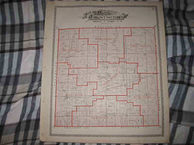
$3.75 Shipping Location: Winter Springs, United States Click Here. Double your traffic. Get Vendio Gallery- Now FREE! Fine antique color lithographed map. Titled Map of Huntington Township. I see Huntington ... moreCentre, and many fascianting areas, the railroads, and more. The map shows the home and land owners, districts, tracts, named railroads and much more. This is an antique map and not a reprint or reproduction. Fine period color lithography, nice outside ornate border, printed on thick paper, with no printing on reverse. The map is from the very rare 1896 American Atlas of Lorain County Ohio. The map is a fascinating and historic period look at this area at this time. The map shows the home and land owners, railroads, and much more. The photo wont show the full beauty of the map. The map is in nice shape, tight and clean. The size of the map is 15.5" by 18.5" Winning bidder pays $3.75 shipping domestic, more foreign. Payment I accept the following forms of payment: PayPal Click to View Image Album Shipping& Handling US Shipping. $3.75 USPS First-Class Mail® International Shipping. $11.50 USPS First-Class Mail International FREE scheduling. Supersized images and templates. Get Vendio Sales Manager. FREE scheduling. Supersized images and templates. Get Vendio Sales Manager.
Buy It Now
$3.75 Shipping Location: Winter Springs, United States Fascianting period map. The handcoloring on the map is period to the map, this is before color printing. The map is from the very rare 1882 Colby Atlas ... moreof Piscataquis County Maine. The photo wont show the full beauty of the map.
Buy It Now
Free Shipping Location: Marana, United States HARRISON - IOWA1922/042421. This Map was removed from a 1922 Atlas and is in good acceptable condition. Study the photos carefully, this is the actual ... moremap you. Only Authentic Originals.
Buy It Now
$4.15 Shipping Location: Saco, United States Up for Sale is an Antique 1877 Roe & Colby Map. The Map was Harvested from an Aroostook County Atlas which was falling apart and could not be salvaged ... moreas a book. This Timberland and/or Plantation Map has Land Owners Listed on Each Lot.

Buy It Now
$3.95 Shipping Location: Clarkston, United States Click Here. Double your traffic. Get Vendio Gallery- Now FREE! VERY LARGE HIGH RESOLUTION MAP COLLECTION ON CD-ROM! please see full table of contents ... moreand sample illustrations below) Hodgeman County Atlas, Kansas including plat maps and land ownership These are scans of the ORIGINAL maps from the Atlas. on CD-ROM System requirements PC or Mac compatible. Files are simple JPEG images with a basic HTML interface(just like viewing a webpage) Works with all versions of Windows including 3.1. 95, 98, 2000 or XP. Features of this CD-ROM This auction is for a CD-ROM of the maps listed in electronic form. NOT the maps themselves. These maps are VERY high resolution and can be printed at FULL SCALE or LARGER for framing and display. The results are very high quality and convincing. For a sample map please: CLICK HERE WARNING! This is a LARGE file(5 Megabytes) if you are using a slow connection it can take some time to load. ks202 Title page, ks203 Table of contents ks204 Outline Map of Hodgeman County. Kansas, ks205 Map of Township 21 S Range 21 W, ks206 Map of Township 21 S Range 22 W, ks207 Map of Township 21 S Range 23 W, ks208 Map of Township 21 S Range 24 W ks209 Map of Township 21 S Range 25 W ks2010 Map of Township 21 S Range 26 W ks2011 Map of Township 22 S Range 21 W, ks2012 Map of Township 22 S Range 22 W ks2013 Map of Township 22 S Range 23 W, ks2014 Map of Township 22 S Range 24 W, ks2015 Map of Township 22 S Range 25 W, ks2016 Map of Township 22 S Range 26 W ks2017 Map of Township 23 S Range 21 W, ks2018 Map of Township 23 S Range 22 W, ks2019 Map of Township 23 S Range 23 W, ks2020 Map of Township 23 S Range 24 W, ks2021 Map of Township 23 S Range 25 W, ks2022 Map of Township 23 S Range 26 W ks2023 Map of Township 24 S Range 21 W ks2024 Map of Township 24 S Range 22 W ks2025 Map of Township 24 S Range 23 W, ks2026 Map of Township 24 S Range 24 W, ks2027 Map of Township 24 S Range 25 W, ks2028 Map of Township 24 S Range 26 W, ks2029 Jetmore; Hanston, ks2030 Kansas ks2031 Map of the United States, ks203
Buy It Now
$3.95 Shipping Location: Clarkston, United States This DVD is part of our Historic Atlas Collection. Title of this Atlas Historical Atlas Map Of. Sonoma County, California. The results are very high quality ... moreand convincing The files are in PDF format for easy of viewing and printing.

Buy It Now
$3.95 Shipping Location: Clarkston, United States Coins of India Reference Library This DVD is part of our Historic Atlas Collection. We have dozens of Atlas maps on CD and DVD ranging from the 1500s ... moreto the 1900s covering many areas and topics. Please Check our Ebay Store for what's available. VERY LARGE HIGH RESOLUTION MAP COLLECTION ON DVD! please see full table of contents and sample illustrations below) Title of this Atlas: Illustrated Atlas Map Of Montgomery County. Illinois Carefully Compiled from Personal Examinations and Surveys. Published by Brink. McCormick& Co. of Illinois. Duval& Hunter. Lithographers, Philada, Pa. 1874 Features of this DVD This auction is for a DVD-ROM of the maps listed in electronic form. NOT the maps themselves. These maps are VERY high resolution and can be printed at FULL SCALE or LARGER for framing and display. The results are very high quality and convincing The files are in PDF format for easy of viewing and printing. Maps can be viewed and many scales and zoom features are available as with any PDF file. 3741001 3741002 3741003 3741004 3741005 3741006 3741007 3741008 3741009 3741010 3741011 3741012 3741013 3741014 3741015 3741016 3741017 3741018 3741019 3741020 3741021 3741022 3741023 3741024 3741025 3741026 3741027 3741028 3741029 3741030 3741031 3741032 3741033 3741034 3741035 3741036 3741037 3741038 3741039 3741040 3741041 3741042 3741043 3741044 3741045 3741046 3741047 3741048 3741049 3741050 3741051 3741052 3741053 3741054 3741055 3741056 3741057 3741058 3741059 3741060 3741061 3741062 3741063 3741064 3741065 3741066 3741067 3741068 3741069 3741070 3741071 Ad and DVD copyright 2011 Euriskodata All Rights Reserved Powered by The free listing tool. List your items fast and easy and manage your active items. o`7.RcmdId ViewItemDescV4,RlogId p4%60bo7%60jtb9%3Fuk%601d72f%2B6mwimiu%3Eo%607-13cf03ca456-0xfe-

Buy It Now
$3.95 Shipping Location: Clarkston, United States Coins of India Reference Library This CD is part of our Historic Atlas Collection. We have dozens of Atlas maps on CD ranging from the 1500s to the 1900s ... morecovering many areas and topics. Please Check our Ebay Store for what's available. VERY LARGE HIGH RESOLUTION MAP COLLECTION ON CD-ROM! please see full table of contents and sample illustrations below) Title of this Atlas: Historical atlas map of Santa Clara County. California Compiled. Drawn and published from personal examinations and surveys by Thompson& West. San Francisco, Cala. 1876. Thos. Hunter Pr. Phil. N. Friend. Engr. Philad. C.L. Smith. Del. 1876 Features of this CD-ROM This auction is for a CD-ROM of the maps listed in electronic form. NOT the maps themselves. These maps are VERY high resolution and can be printed at FULL SCALE or LARGER for framing and display. The results are very high quality and convincing The files are in PDF format for easy of viewing and printing. Maps can be viewed and many scales and zoom features are available as with any PDF file. 0002256B 0002256C 0002256A 2256001 2256002 2256003 2256004 2256005 2256006 2256007 2256008 2256009 2256010 2256011 2256012 2256013 2256014 2256015 2256016 2256017 2256018 2256019 2256020 2256021 2256022 2256023 2256024 2256025 2256026 2256027 2256028 2256029 2256030 2256031 2256032 2256033 2256034 2256035 2256036 2256037 2256038 2256039 2256040 2256041 2256042 2256043 2256044 2256045 2256046 2256047 2256048 2256049 2256050 2256051 2256052 2256053 2256054 2256055 2256056 2256057 2256058 2256059 2256060 2256061 2256062 2256063 2256064 2256065 2256066 2256067 2256068 2256069 2256070 2256071 2256072 2256073 2256074 2256075 Ad and CD-ROM copyright 2011 Euriskodata All Rights Reserved Powered by The free listing tool. List your items fast and easy and manage your active items.
Buy It Now
$4.99 Shipping Location: Fairview, United States Illustrated Atlas of Cuyahoga County Ohio, published in Philadelphia by Titus & Simmons, 1874. A copy of the title page is included with the map for authenticity. ... moreCondition: It is in Good condition with a strong impression, bright handcoloring, blank on reverse and printed on a heavy page.
Buy It Now
Free Shipping Location: Marana, United States HARRISON - IOWA1922/042421. This Map was removed from a 1922 Atlas and is in good acceptable condition. Study the photos carefully, this is the actual ... moremap you. Only Authentic Originals.
Buy It Now
Free Shipping Location: Marana, United States HARRISON - IOWA1922/042421. This Map was removed from a 1922 Atlas and is in good acceptable condition. Study the photos carefully, this is the actual ... moremap you. Only Authentic Originals.
Buy It Now
Free Shipping Location: Marana, United States HARRISON - IOWA1922/042421. This Map was removed from a 1922 Atlas and is in good acceptable condition. Study the photos carefully, this is the actual ... moremap you. Only Authentic Originals.
Buy It Now
Free Shipping Location: Marana, United States HARRISON - IOWA1922/042421. This Map was removed from a 1922 Atlas and is in good acceptable condition. Study the photos carefully, this is the actual ... moremap you. Only Authentic Originals.
Buy It Now
Free Shipping Location: Kennebunk, United States This Map was removed from a 1889 Atlas and is in good acceptable condition. Study the photos carefully, this is the actual map you. Only Authentic Originals.
Buy It Now
$3.95 Shipping Location: Clarkston, United States Crawford County, Iowa. Crawford01 Cover Crawford02 Standard Atlas of Crawford County, Iowa - Title Page. This DVD is part of our Historic Atlas Collection. ... moreTitle of this Atlas Standard Atlas of. Crawford36 Patron's Reference Directory Crawford37 Patron's Reference Directory continued.

Buy It Now
$3.50 Shipping Location: Clarkston, United States Click Here. Double your traffic. Get Vendio Gallery- Now FREE! Clarion county This CD is part of our Historic Map and Atlas Collection. We have dozens ... moreof Atlas maps on CD ranging from the 1500s to the 1900s covering many areas and topics. Please Check our Ebay Store for what's available. VERY LARGE HIGH RESOLUTION MAP COLLECTION ON CD-ROM! please see full table of contents and sample illustrations below) Title of this Atlas: Caldwell's Illustrated Historical Combination Atlas of Clarion County. Pennsylvania from actual surveys by& under the directions of Henry Cring; assisted by C.T. Arms. et al. 1877 Features of this CD-ROM This auction is for a CD-ROM of the maps listed in electronic form. NOT the maps themselves. These maps are VERY high resolution and can be printed at FULL SCALE or LARGER for framing and display. The results are very high quality and convincing The files are in PDF format for easy of viewing and printing. Maps can be viewed and many scales and zoom features are available as with any PDF file. ca000001 ca000002 ca000003 ca000004 ca000006 ca000008 ca000009 ca000010 ca000011 ca000012 ca000013 ca000014 ca000015 ca000016 ca000017 ca000018 ca000019 ca000020 ca000021 ca000022 ca000023 ca000024 ca000025 ca000026 ca000027 ca000028 ca000030 ca000031 ca000032 ca000033 ca000034 ca000035 ca000036 ca000038 ca000039 ca000040 ca000042 ca000043 ca000044 ca000045 ca000047 ca000048 ca000049 ca000050 ca000051 ca000052 ca000053 ca000055 ca000056 ca000057 ca000059 ca000060 ca000061 ca000063 ca000064 ca000065 ca000066 ca000067 ca000068 ca000069 ca000070 ca000071 ca000072 ca000073 ca000074 ca000075 ca000076 ca000077 ca000078 ca000079 ca000080 ca000081 ca000082 ca000083 ca000084 ca000085 ca000086 ca000087 ca000088 ca000089 ca000090 ca000091 ca000092 ca000093 ca000094 ca000095 ca000096 ca000097 ca000098 ca000099 ca000101 ca000102 ca000103 ca000104 ca000105 ca000106 ca000107 ca000108 ca000109 ca000110 ca000112 ca000113 ca000114 ca000115 ca000116 ca000118 ca000119 ca000120 ca000121 ca000122 ca000123 ca000
Buy It Now
Free Shipping Location: Marana, United States HARRISON - IOWA1922/042421. This Map was removed from a 1922 Atlas and is in good acceptable condition. Study the photos carefully, this is the actual ... moremap you. Only Authentic Originals.
Buy It Now
Free Shipping Location: Marana, United States HARRISON - IOWA1922/042421. This Map was removed from a 1922 Atlas and is in good acceptable condition. Study the photos carefully, this is the actual ... moremap you. Only Authentic Originals.

Buy It Now
$3.75 Shipping Location: Winter Springs, United States Click Here. Double your traffic. Get Vendio Gallery- Now FREE! Vintage antique 1914 color lithographed map. The map is titled Madison. This is Madison ... moreTownship. The map shows the period named land owners, named railroads, size and location of lots, and much more. The map is printed on thick paper with no printing on reverse. The condition of the map is very nice. This is an antique map and not a reprint or reproduction. The map is from the very rare 1914 Carson B. Davis, C.E. Atlas of Guernsey County Ohio. The map is a fascinating and historic period look at this area at this time. The photo wont show the full beauty of the map. The size of the map is 14" by 17" Winning bidder pays $3.75 shipping domestic, more foreign. Payment I accept the following forms of payment: PayPal Click to View Image Album Shipping& Handling US Shipping. $3.75 USPS First-Class Mail® International Shipping. $11.50 USPS First-Class Mail International FREE scheduling. Supersized images and templates. Get Vendio Sales Manager. FREE scheduling. Supersized images and templates. Get Vendio Sales Manager.
Buy It Now
Free Shipping Location: Marana, United States HARRISON - IOWA1922/042421. This Map was removed from a 1922 Atlas and is in good acceptable condition. Study the photos carefully, this is the actual ... moremap you. Only Authentic Originals.
Buy It Now
Free Shipping Location: Marana, United States HARRISON - IOWA1922/042421. This Map was removed from a 1922 Atlas and is in good acceptable condition. Study the photos carefully, this is the actual ... moremap you. Only Authentic Originals.

Buy It Now
$4.00 Shipping Location: Winter Springs, United States Click Here. Double your traffic. Get Vendio Gallery- Now FREE! Vintage antique handcolored 1906 map. Large. Beautiful antique handcolored. The map is ... moretitled Middlesex County, City of Woburn, Part of Wards 2, 4& 5. The map is in beautiful conditon, many fascianting areas on the map, the detail is just amazing, showign the named home and land owners, size and style of building, named business and industry, named schools, named churches, named roads, named ponds, named railroads and much more. There is an Explanation chart corresponding to the map itself, showing style of building. The map is very finely printed on superb period thick paper. The map is beautifully handcolored, so few of these maps were done, it was easier and less expensive to have them handcolored. This is an antique map and not a reprint or reproduction. The map is in nice conditon, and would frame and display beautifully. Very rare. The map is from the rare 1906 George Walker Atlas of Middlesex County Massachusetts. The size of the map is 22" by 32" Winning bidder pays $4.00 shipping domestic, more foreign. Payment I accept the following forms of payment: PayPal Click to View Image Album Shipping& Handling $4.00 USPS First-Class Mail® FREE scheduling. Supersized images and templates. Get Vendio Sales Manager. FREE scheduling. Supersized images and templates. Get Vendio Sales Manager. Win more auctions at the last minute FREE. Learn how.
Buy It Now
Free Shipping Location: Marana, United States HARRISON - IOWA1922/042421. This Map was removed from a 1922 Atlas and is in good acceptable condition. Study the photos carefully, this is the actual ... moremap you. Only Authentic Originals.
Buy It Now
Free Shipping Location: Marana, United States HARRISON - IOWA1922/042421. This Map was removed from a 1922 Atlas and is in good acceptable condition. Study the photos carefully, this is the actual ... moremap you. Only Authentic Originals.
Buy It Now
Free Shipping Location: Old Orchard Beach, United States This Map was removed from a 1904 Atlas and is in good acceptable condition. will receive. The Double page is approx 17 1/2" x 29 1/2". This map is not ... moredated. 110+ years of aging. Study the photos carefully, this is the actual map you.
Buy It Now
$8.20 Shipping Location: College Station, United States Brazos County, Texas Old Wall Map Reprint Of Land Owners 1800s.
Buy It Now
$3.95 Shipping Location: Clarkston, United States Androscoggin County, Maine. The results are very high quality and convincing The files are in PDF format for easy of viewing and printing. This DVD is ... morepart of our Historic Atlas Collection. Features of this DVD.
Buy It Now
Free Shipping Location: Kennebunk, United States This Map was removed from a 1922 Atlas and is in good acceptable condition. Study the photos carefully, this is the actual map you. Only Authentic Originals.

Buy It Now
$3.75 Shipping Location: Winter Springs, United States Click Here. Double your traffic. Get Vendio Gallery- Now FREE! Fine large antique 1921 color lithographed map. Titled Map of Highland Township. I see ... moremany interesting areas, the map has a tape repair across it, the named railroads, named home and land owners, locations of buildings, size of land parcels and much more of this period. The map is printed on thick paper, with no printing on reverse. Fascianting, detailed and attractive period map of this area of Nebraska at this time. The map is from the very rare 1921 Anderson Publishing Company Atlas of Lancaster County Nebraska. The size of the map is 15" by 18" Rare. Winning bidder pays $3.75 shipping domestic, more foreign. Payment I accept the following forms of payment: PayPal Click to View Image Album Shipping& Handling US Shipping. $3.75 USPS First-Class Mail® International Shipping. $11.50 USPS First-Class Mail International FREE scheduling. Supersized images and templates. Get Vendio Sales Manager. FREE scheduling. Supersized images and templates. Get Vendio Sales Manager.

Buy It Now
$4.00 Shipping Location: Winter Springs, United States Click Here. Double your traffic. Get Vendio Gallery- Now FREE! Vintage antique 1865 handcolored map. The map is titled Edwards. With Edwards inset map. ... moreOn the main map I see Edwards PO, South Edwards PO, Freemansburgh, and much more. The map is in nice conditon. This is an antique map and not a reprint or reproduction. The handcoloring on the map is period to the map, this is before color printing. The map is from the very rare 1865 Beers Atlas of St Lawrence County New York. The map is a fascinating and historic period look at this area at this time. The map shows the home and land owners, the business and industry, the few roads, railroads etc that existed at that time. The photo wont show the full beauty of the map. The map is in nice shape and would frame and display quite beautifully. The size of the map is 15" by 14.5" Winning bidder pays $4.00 shipping domestic, more foreign. Payment I accept the following forms of payment: PayPal Click to View Image Album Shipping& Handling US Shipping. $4.00 USPS First-Class Mail® International Shipping. $11.50 USPS First-Class Mail International FREE scheduling. Supersized images and templates. Get Vendio Sales Manager. FREE scheduling. Supersized images and templates. Get Vendio Sales Manager. 16.RcmdId ViewItemDescV4,RlogId p4%60bo7%60jtb9%3Feog4d71f%2B%3E16%3E-14b5dc77893-0x115-

Buy It Now
$3.95 Shipping Location: Clarkston, United States Click Here. Double your traffic. Get Vendio Gallery- Now FREE! Rare Map Collection This DVD is part of our Historic Map and Atlas Collection. We have ... moredozens of Atlas maps on DVD and CD ranging from the 1500s to the 1900s covering many areas and topics. Please Check our Ebay Store for what's available. FOR MANY MORE EDUCATIONAL CD TITLES ON THIS AND MANY OTHER SUBJECTS PLEASE VISIT OUR EBAY STORE VERY LARGE HIGH RESOLUTION MAP COLLECTION ON DVD! please see full table of contents and sample illustrations below) This DVD Contains Atlas of City Atlas Of Newport Rhode Island From official Records Private Plans and Actual Surveys. Based upon Plans deposited in the Department of Surveys. Surveyed& Published under the Direction Of G.M. Hopkins, C.E. 320 Walnut Street, Philadelphia. 1876. Engraved by Edward Busch, 320 Walnut Street. Printed by F. Bourquin, 31 So. 6th Street Phila. Entered. 1876 by G.M. Hopkins. Washington D.C. 1876 These are scans of the ORIGINAL maps by various Cartographers. on DVD System requirements PC or Mac compatible. Files are simple PDF files with a basic HTML interface(just like viewing a webpage) Works with ALL versions of Windows. Atlas of Newport Rhode Island 4831001 4831002 4831003 4831004 4831005 4831006 4831007 4831008 4831009 4831010 4831011 4831012 4831013 4831014 4831015 4831016 4831017 4831018 4831019 4831020 4831021 4831022 4831023 4831024 4831025 4831026 4831027 4831028 4831029 Features of this DVD This auction is for a DVD of the maps listed in electronic form. NOT the maps themselves. These maps are VERY high resolution and can be printed at FULL SCALE or LARGER for framing and display. The results are very high quality and convincing. Ad and disk copyright 2013 Euriskodata All Rights Reserved Powered by The free listing tool. List your items fast and easy and manage your active items.

Buy It Now
$3.75 Shipping Location: Winter Springs, United States Click Here. Double your traffic. Get Vendio Gallery- Now FREE! Vintage antique 1874 handcolored map. The map is titled Mifflin. Mifflin Township, and ... moreTroy, Troy Township. The map shows the named land and home owners, named business and industry, named railroads, locations of buildings, and much more. The map is printed on thick paper, with no printing on reverse. The condition of the map is nice. This is an antique map and not a reprint or reproduction. The handcoloring on the map is period to the map, this is before color printing, the map is printed on thick paper, with no printing on reverse. The map is from the very rare 1874 J.A. Caldwell Atlas of Ashland County Ohio. The map is a fascinating and historic period look at this area at this time. The photo wont show the full beauty of the map. The size of the map is 14" by 17" Winning bidder pays $3.75 shipping domestic, more foreign. Payment I accept the following forms of payment: PayPal Click to View Image Album Shipping& Handling US Shipping. $3.75 USPS First-Class Mail® International Shipping. $11.50 USPS First-Class Mail International FREE scheduling. Supersized images and templates. Get Vendio Sales Manager. FREE scheduling. Supersized images and templates. Get Vendio Sales Manager. dhep.RcmdId ViewItemDescV4,RlogId p4%60bo7%60jtb9%3Fuk%601d72f%2Bishm%3Ed%7Fhep-144bdd55172-0x102-
Buy It Now
$6.80 Shipping Location: Eland, United States 1988 Land Atlas & Plat Book. Fond du Lac County Wisconsin. Index to owners & renters. Small tract owners.
Buy It Now
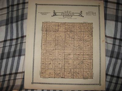
$3.75 Shipping Location: Winter Springs, United States Click Here. Double your traffic. Get Vendio Gallery- Now FREE! Fine large antique 1921 color lithographed map. Titled Map of Stockton Township. I see ... moremany interesting areas, the named railroads, named home and land owners, locations of buildings, size of land parcels and much more of this period. The map is printed on thick paper, with no printing on reverse. Fascianting, detailed and attractive period map of this area of Nebraska at this time. The map is from the very rare 1921 Anderson Publishing Company Atlas of Lancaster County Nebraska. The size of the map is 15" by 18" Rare. Winning bidder pays $3.75 shipping domestic, more foreign. Payment I accept the following forms of payment: PayPal Click to View Image Album Shipping& Handling US Shipping. $3.75 USPS First-Class Mail® International Shipping. $11.50 USPS First-Class Mail International FREE scheduling. Supersized images and templates. Get Vendio Sales Manager. FREE scheduling. Supersized images and templates. Get Vendio Sales Manager. RcmdId ViewItemDescV4,RlogId p4%60bo7%60jtb9%3Feog4d71f%2B%3F4f%3E-14be892b81f-0x119-
Buy It Now
$3.95 Shipping Location: Clarkston, United States This DVD is part of our Historic Atlas Collection. Title of this Atlas The results are very high quality and convincing The files are in PDF format for ... moreeasy of viewing and printing. Features of this DVD.
Buy It Now
$3.95 Shipping Location: Clarkston, United States Westchester County, New York. Entered. 1881, by G.W. Bromley & Co. Washington. This DVD is part of our Historic Atlas Collection. Title of this Atlas ... moreMAP COLLECTION. Features of this DVD. The results are very high quality and convincing The files are in PDF format for easy of viewing and printing.
|
|
|
In
|
Hixson wall map Hancock County Findlay OH 1902 land owners names property lines
Description Vintage Findlay Republican 1902 wall map of Hancock County. Ohio. Very detailed, it shows all property borders(as well as parcel sizes in acres) and the name of each land owner. A great piece of historical reference from the turn of the 20th Century. Printed by the W. W. Hixson Map Co. of Rockford, Ill. using data from the 1900 US census. The map is lacquered canvas and measures 56" tall x 50" wide, tacked to wood dowels at top and bottom. It is a little frayed near the edges, shows a few spots of staining but no major defects or tears. I would consider it very good for it's age. All payments are due within 5 days. If you need more time to pay. Please contact me and we can work out the details, it usually won't be a problem. If I receive no contact or payment after 5 days, I reserve the right to relist the item ... moreor offer it to the back-up bidder directly. Ebay policy requires that I only I accept Paypal. wink, wink. nudge, nudge. you know what I mean. I ship USPS and UPS(whichever is most economical for you) usually within 1 business day of receipt of cleared payment. Most items are also available for local pick-up free of charge. I will try to combine shipping to save you money. INTERNATIONAL BIDDERS* Customs fees for your country are your responsibility. Please do not ask me to misrepresent item values on customs forms. I will not do it. If this is unacceptable, please do not bid. USPS First Class Intl. shipping is available for items under 4 lbs. Please understand while this option is economical, it cannot be tracked and can also be quite slow(up to 4 weeks in some cases) please be patient. If you prefer tracking, please choose Priority shipping. If any item is not as I described just return within 14 days and I will refund your purchase. The wide variety of items I sell come from local estates/auctions and are in used condition and therefore. Will show some wear. I will describe the item as best I can to point out any major flaws and always welcome any additional information anyon
|
|
|
1996 Wayne County Illinois Land Atlas & Plat Book With maps & Index to Owners
For sale is the 19996 land atlas and plat book for Wayne County County in Illinois. This hard-to-find publication contains maps. Advertisements and an index of owners for the following townships: Arrington, Barnhill, Bedford, Berry, Big Mound, Elm River, Four Mile, Garden Hill, Grover,Hickory Hill, Indian Prairie, Jasper, Keith, Lamard, Leech, Massilon, Mount Erie, Orchard, Orel and Zif. It is in very good condition. See my listings for other vintage items. I gladly combine shipping fees for multiple purchases when they can be packaged together, and I do ship internationally. Please e-mail me with any questions, and thankls for looking! Powered by The free listing tool. List your items fast and easy and manage your active items.
|
|
|
ANTIQUE 1905 RURAL TOWNSHIP ROCK ISLAND COUNTY ILLINOIS MAP W LAND OWNERS NR
Click Here. Double your traffic. Get Vendio Gallery- Now FREE! Vintage antique 1905 color lithographed map. Gorgeous, titled, in fancy antique lettering, Map of Rural Township, with 1905 printing date at top left, I see many fascianting areas. The map is in gorgeous condition. The map shows the named home and land owners, named railroads, named business and industry, size of land parcels, fine outside ornate border and more. Printed on thick fine paper, with no printing on revers, fine outside ornate bodrer as well. This is an antique map and not a reprint or reproduction. The map is from the very rare 1905 Iowa Publishing Company Atlas of Rock Island County Illinois. The map is a fascinating and historic period look at this area at this time. The photo wont show the full beauty of the map. The map is in nice shape and would frame and display ... morequite beautifully. The size of the 2 page map is 15.5" by 18.5" Winning bidder pays $4.00 shipping domestic, more foreign. Payment I accept the following forms of payment: PayPal Click to View Image Album Shipping& Handling US Shipping. $4.00 USPS First-Class Mail® International Shipping. $11.50 USPS First-Class Mail International FREE scheduling. Supersized images and templates. Get Vendio Sales Manager. FREE scheduling. Supersized images and templates. Get Vendio Sales Manager.
|
|
|
ANTIQUE EDGAR COUNTY ILLINOIS ASSESSOR'S PARCEL MAP LAND OWNERS IN 1902
This 113 year old map rolls up like a window blind and is approximately 46" x 60" The bottom has damage on the first couple of inches. The names of all of the property owners of 1902 and their lots are listed. It is housed in a wooden case meant to hang on the wall. It is a type of canvis. If you were born in this area your relatives names could be listed here. Offers are responded to 24 hours a day.
|
|
 |