-
Christian Collectibles
-
Christian Sheet Music
-
Vatican Stamps
-
Vatican Coins & Paper Money
-
Antiques
-
Antiquities
-
Architectural & Garden
-
Decorative Arts
-
Ethnographic
-
Furniture
-
Maps, Atlases & Globes
-
United States (Pre-1900)
-
United States (1900-Now)
-
AK, HI
-
AL, FL, GA, MS, NC, SC
-
AR, IA, KS, LA, MO, NE
-
AZ, CA, CO, NM, NV, UT
-
CT, MA, ME, NH, RI, VT
-
DC, DE, MD, NJ, NY, PA
-
ID, OR, WA
-
IL, IN, MI, OH, WI
-
MN, MT, ND, SD, WY
-
OK, TX
-
VA, WV, KY, TN
-
Entire US
-
United States (Date Unknown)
-
Africa
-
Asia
-
Australasia/ Oceania
-
Canada
-
Central America/ Caribbean
-
Europe
-
India
-
Ireland
-
Mexico
-
Middle East
-
North America
-
South America
-
United Kingdom
-
Maps on CD
-
World Maps
-
Globes
-
Mixed Lots
-
Reproductions
-
Price Guides & Publications
-
Other
|
In
Order by: Available to: This site contains affiliate links for which I may be compensated
|
Buy It Now
$5.95 Shipping Location: Milan, United States This is the 1984 revision of the 1955 Rock Island County highway map. The map is clean and bright with some light tanning. There is significant edge wear ... moreand chipping throughout as well as some edge rips. The fold lines show quite a bit of wear. A solid copy that has seen some use.
Buy It Now
Free Shipping Location: Schertz, United States This Map was removed from a 1875 Plat Atlas and is in good acceptable condition. The map is not " new " or in " new " condition, it was printed in 1875. ... moreThe map is not dated. Study the photos carefully, this is the actual map you will receive.

Buy It Now
$3.50 Shipping Location: Winter Springs, United States Click Here. Double your traffic. Get Vendio Gallery- Now FREE! Vintage antique 1905 color lithographed map titled. In fancy antique lettering, Map of ... moreCordova Township a with 1905 printing date at top left, I see many fascianting areas. I see Cordova and more. The map is incomplete and some is lost, see my photo. The map shows the named home and land owners, named railroads, named business and industry, size of land parcels, fine outside ornate border and more. Printed on thick fine paper, with no printing on revers, fine outside ornate bodrer as well. This is an antique map and not a reprint or reproduction. The map is from the very rare 1905 Iowa Publishing Company Atlas of Rock Island County Illinois. The map is a fascinating and historic period look at this area at this time. The photo wont show the full beauty of the map. The size of the map is 12" by 18" Winning bidder pays $3.50 shipping domestic, more foreign. Payment I accept the following forms of payment: PayPal Click to View Image Album Shipping& Handling US Shipping. $3.50 USPS First-Class Mail® International Shipping. $11.50 USPS First-Class Mail International FREE scheduling. Supersized images and templates. Get Vendio Sales Manager. FREE scheduling. Supersized images and templates. Get Vendio Sales Manager.
Buy It Now
$6.80 Shipping Location: Eagle, United States Map of Whiteside County & Rock Island County-Reversible Illinois from an 1870 Plat Book.
Buy It Now
$8.70 Shipping Location: Eagle, United States
Buy It Now
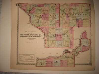
Free Shipping Location: Schertz, United States This antique original map page was printed in 1874 by Warner & Beers Publishers. Measuring 14x17 inches, the map depicts Jo Daviess, Stephenson, Carroll, ... moreand Rock Island counties in Illinois. All colors on the map are original, providing an accurate representation of the region as it was over 140 years ago. The map comes in the format of an atlas map and is a perfect addition to any collection of North American maps, or for those interested in antiques. Free shipping and handling is available within the USA, while calculated shipping and handling is available worldwide. Get this unique piece of history while it's still available!
Buy It Now
$4.13 Shipping Location: Milan, United States This folding map is in very good vintage condition. It is clean and bright with some light tanning and corner, examples pictured. A clean solid piece. ... moreThis item will ship folded.
Buy It Now
$4.50 Shipping Location: United States Very finely produced map, printed on thick fine paper. This is an antique map and not a reprint or reproduction. The map is from the very rare 1876 Illustrated ... moreHistorical Atlas of the State of Illinois, by Warner and Beers, produced in 1876.

Buy It Now
$4.00 Shipping Location: Winter Springs, United States Click Here. Double your traffic. Get Vendio Gallery- Now FREE! Vintage antique 1905 color lithographed map. Gorgeous, titled Map of Drury Township, with ... moredetailed Reference chart, coresponding to the map itself, then date of 1905 below the title, this dates the map nicely, esp. if framed. The map shows the named home and land owners, named railroads, named business and industry, size of land parcels, fine outside ornate border and more. Printed on thick fine paper, with no printing on revers, fine outside ornate bodrer as well. This is an antique map and not a reprint or reproduction. The map is from the very rare 1905 Iowa Publishing Company Atlas of Rock Island County Illinois. The map is a fascinating and historic period look at this area at this time. The photo wont show the full beauty of the map. The map is in nice shape and would frame and display quite beautifully. The size of the 2 page map is 18.5" by 30" Winning bidder pays $4.00 shipping domestic, more foreign. Payment I accept the following forms of payment: PayPal Click to View Image Album Shipping& Handling US Shipping. $4.00 USPS First-Class Mail® International Shipping. $11.50 USPS First-Class Mail International FREE scheduling. Supersized images and templates. Get Vendio Sales Manager. FREE scheduling. Supersized images and templates. Get Vendio Sales Manager.
Buy It Now
$5.95 Shipping Location: Milan, United States This map is in nice vintage shape. It is clean and bright with a few light marks and normal creasing along fold lines. One side shows Whiteside County, ... morethe other shows various cities as pictured. Advertising throughout. A clean solid piece.
Buy It Now
Free Shipping Location: Anaheim, United States Typically that map at hand, the one being looked at, is in the center box. Woodland areas. feature within the bounds of the map, which frequently is a ... morecommunity, town, or city. The map covers a specific amount of area.
Buy It Now
$8.70 Shipping Location: Eagle, United States
Buy It Now
Free Shipping Location: Schertz, United States This Map was removed from an 1873 MADISON COUNTY, ILLINOIS Plat Atlas and is in fair condition. The map is not " new " or in " new " condition, it was ... moreprinted in 1873. Study the photos carefully, this is the.
Buy It Now
$3.00 Shipping Location: Rockville, United States Lakeside Building Cor. - Chicago 1876 by Warner & Beers. Up for sale is a great, antique map, titled - "MAP OF ROCK ISLAND COUNTY - ILLINOIS - 1876". ... moreThe map has fantastic coloring to it. There are tears along one of the edges from where it was separated from the binding of the Atlas.
Buy It Now
$4.00 Shipping Location: United States Click Here. Double your traffic. Get Vendio Gallery- Now FREE! Vintage antique 1875 handcolored map. Very nicely printed on thick paper. No printing on ... moreverso. This is an antique 1875 map and not a reprint or reproduction. The superb handcoloring on the map is period, this is before color printing. The map is in gorgeous, very superb condition. The map is titled, in fancy antique lettering,Atlas of Illinois, Counties of Jo Daviess, Stephenson, Carroll and Rock Island, Warner& Beers, Publishers. Amazing period map. There is a detailed References chart, corresponding to the map itself, with Townships County Seats, Towns, Post Offices, Creeks, Railroads finished, Railroads projected, and Public Lands, corresponding to the map. Beautifully detailed period map of these areas at this time. Warner and Beers were very highly regarded mapmakers of this period. The map is printed on fine thick paper, with no printing on reverse, fine outside ornate border as well. This is an antique map and not a reprint or reproduction. The map is from the very rare 1875 Illustrated Historical Atlas of Macoupin County Illinois. The map is a fascinating and historic period look at this area at this time. The photo wont show the full beauty of the map. The map is in nice shape and would frame and display quite beautifully. The size of the map is 16" by 18.5" Winning bidder pays $4.00 shipping domestic, more foreign. Payment I accept the following forms of payment: PayPal Click to View Image Album Shipping& Handling US Shipping. $4.00 USPS First-Class Mail® International Shipping. $11.50 USPS First-Class Mail International FREE scheduling. Supersized images and templates. Get Vendio Sales Manager. FREE scheduling. Supersized images and templates. Get Vendio Sales Manager.
Buy It Now
$3.75 Shipping Location: United States Very finely produced map, printed on thick fine paper. This is an antique map and not a reprint or reproduction. The map is from the very rare 1876 Illustrated ... moreHistorical Atlas of the State of Illinois, by Warner and Beers, produced in 1876.

Buy It Now
$4.00 Shipping Location: Winter Springs, United States Click Here. Double your traffic. Get Vendio Gallery- Now FREE! Vintage antique 1905 color lithographed map. Gorgeous, titled, in fancy antique lettering, ... moreMap of Rural Township, with 1905 printing date at top left, I see many fascianting areas. The map is in gorgeous condition. The map shows the named home and land owners, named railroads, named business and industry, size of land parcels, fine outside ornate border and more. Printed on thick fine paper, with no printing on revers, fine outside ornate bodrer as well. This is an antique map and not a reprint or reproduction. The map is from the very rare 1905 Iowa Publishing Company Atlas of Rock Island County Illinois. The map is a fascinating and historic period look at this area at this time. The photo wont show the full beauty of the map. The map is in nice shape and would frame and display quite beautifully. The size of the 2 page map is 15.5" by 18.5" Winning bidder pays $4.00 shipping domestic, more foreign. Payment I accept the following forms of payment: PayPal Click to View Image Album Shipping& Handling US Shipping. $4.00 USPS First-Class Mail® International Shipping. $11.50 USPS First-Class Mail International FREE scheduling. Supersized images and templates. Get Vendio Sales Manager. FREE scheduling. Supersized images and templates. Get Vendio Sales Manager.
Buy It Now
Free Shipping Location: Marana, United States This Map was removed from a 1876 Atlas and is in good acceptable condition. the page edges, foxing, spots, paper browning & brittle paper from over. This ... moreis 1 single page with a map on one side and a map or print on the reverse side.
Buy It Now
$5.00 Shipping Location: Jacksonville, United States 1876 Rock Island Illinois county map, with Whiteside on the reverse. A beautiful and colorful map from the Historical Atlas of the State of Illinois, ... morepublished in 1876. This map has great presence and nice original hand coloring.
Buy It Now
$8.70 Shipping Location: Eagle, United States
Buy It Now
$5.15 Shipping Location: Galena, United States 1870s Whiteside County . Village map insets of Round Grove & Lyndon.
Buy It Now
$8.70 Shipping Location: Eagle, United States Illinois, Rock Island County, 1905 Plat Map, Plat of Reynolds Double-Sided. Presented is a 1905 plat map of Rock Island County, Illinois. Featuring the ... moreplat of Reynolds. Map reverses to show plats of Edgington and Taylor Ridge.
Buy It Now
$8.70 Shipping Location: Eagle, United States Presented is a 1905 plat map of Rock Island County, Illinois. This map reverses to plats of Cordora and Hillsdale.
Buy It Now
Free Shipping Location: Kennebunk, United States This Map was removed from a 1876 Atlas and is in good acceptable condition. Study the photos carefully, this is the actual map you. Only Authentic Originals.
Buy It Now
$8.70 Shipping Location: Eagle, United States Presented is a 1905 plat map of Rock Island County, Illinois.
Buy It Now
$8.70 Shipping Location: Eagle, United States Presented is a 1905 plat map of Rock Island County, Illinois.
Buy It Now
$8.70 Shipping Location: Eagle, United States Presented is a 1905 plat map of Rock Island County, Illinois. This map features plats of Andalusia and reverses to show Illinois City.
Buy It Now
$8.70 Shipping Location: Eagle, United States Presented is a 1905 plat map of Rock Island County, Illinois. This map reverses to plats of East Rock Island East Moline Heights, Watertown and Kendallville.
Buy It Now
$6.80 Shipping Location: Eagle, United States Presented is an authentic old hand-colored map taken from a dis-bound atlas published in 1876.
Buy It Now
$11.60 Shipping Location: Pekin, United States Counties of Pike, Scott, Morgan, Greene, Jersey, and Calhoun.Hancock, Brown, and Adams. Double page Warner & Beers map. 1873 Illinois Atlas .
Buy It Now
$4.69 Shipping Location: Greenacres, United States This is the 1929 edition of the Smithland quadrangle, based on surveys in 1926. Genuine original color lithographed fold-out dissected topographical map ... moreof parts of Livingston and Marshall counties, Kentucky, and Pope and Massac counties, Illinois, printed more than 92 years ago.
Buy It Now
Free Shipping Location: Savannah, United States Original 126-year-old Antique Map of Illinois Drawn and Engraved for the 1898 Edition of The Columbian Atlas of The World, Featuring Large Scale Color ... moreMaps of Each State, Principal City, and Territory of The United States, the Provinces of Canada, Every Country, Nation, Sovereign Kingdom, and Civil Division Upon the Face of the Globe; Accompanied by a Margin Reference Index of County, City, and Town populations of the 1890 US Census; Together with a Concise History of Earth's Peoples richly Illustrated with Engravings. Intricate Detail of County Lines, Towns, Railroads, along with Rivers, Lakes, and Natural Landmarks. Fine Map for the Historian or Collector. Great for American History and Family Genealogy. Makes an Imaginative and Creative Gift. Easily Framed.
Buy It Now
$15.00 Shipping Location: Brooklyn, United States This map was compiled and drawn by D. B. Allen, County Surveyor for Franks' Peoria City Directory and published in 1893. Title: Map of Franks' Peoria ... moreCity Directory. Others advertise a patent and trade mark law office, Illinois coal, and a 'practical aeronaut'.
Buy It Now
$4.69 Shipping Location: Greenacres, United States The map was published by the State of Kentucky Geological Survey and is identified as the 1917 edition of the Uniontown quadrangle, based on surveys in ... more1914 and printed in 1929. Genuine original color lithographed fold-out dissected topographical map of parts of Henderson and Union counties, Kentucky, and Posey County, Indiana, printed more than 93 years ago.

Buy It Now
$3.95 Shipping Location: Rochester, United States RARE Old Pocket Map Colton's Township Map of Pennsylvania and the Southern Counties of New York 1876 For offer. A very interesting American imprint! ... moreFresh from a local estate- never offered on the market until now! I could not locate a copy of this book for sale anywhere. Vintage. Old, Original, Antique- NOT a Reproduction- Guaranteed! New York: Colton. 1876. Nicely Hand colored. 44 x 30 inches when fully unfolded. COMPLETE. In very good condition. Acid free archival repair to rips on back and a few fold joints. Front cover nearly detached, hanging on by small piece of paper. Light age toning/ minimal foxing. Please see photos. If you collect 19th century American imprints. Americana illustration, atlas, State of PA- Southern Tier NY, etc. this is a nice one for your bibliophile library or paper/ ephemera collection. Combine shipping on multiple bid wins! Pennsylvania Listeni/ˌpɛnsɨlˈveɪnjə/ Pennsylvania German: Pennsilfaani) Officially the Commonwealth of Pennsylvania, is a U.S. state that is located in the Northeastern and Mid-Atlantic regions of the United States, and the Great Lakes region. The state borders Delaware to the southeast, Maryland to the south, West Virginia to the southwest, Ohio to the west, Lake Erie and Ontario, Canada to the northwest, New York to the north and New Jersey to the east. The Appalachian Mountains run through the middle of the state. Pennsylvania is the 33rd largest. The 6th most populous, and the 9th most densely populated of the 50 United States. The state's five most populous cities are Philadelphia, Pittsburgh, Allentown, Erie, and Reading. The state capital is Harrisburg. Pennsylvania has 51 miles(82 km) of coastline along Lake Erie and 57 miles(92 km)6] of shoreline along the Delaware Estuary. The state is one of the 13 original founding states of the United States. Geography Further information: Geography of Pennsylvania and List of counties in Pennsylvania Counties of Pennsylvania Pennsylvania is 170 miles(274 km) north to south and 283 miles(455 km) ea
Buy It Now
$12.85 Shipping Location: Rochester, United States See also: List of artists and writers from Alaska. A dog team in the Iditarod Trail Sled Dog Race, arguably the most popular winter event in Alaska. Alaska ... moreMining District. Alaska Interstate Highways.
Buy It Now
$12.85 Shipping Location: Floral Park, United States This is an original on linen 1907 Allegheny City, Pittsburgh, Pennsylvania P lat Atlas Map. Condition: VG+/EX 23X32 - On Linen - Hand Notations - See ... morePhotos.
|
|
|
In
|
ANTIQUE SOUTH & ROCK ISLAND TOWNSHIP ARSENAL ROCK ISLAND COUNTY ILLINOIS MAP NR
Click Here. Double your traffic. Get Vendio Gallery- Now FREE! Vintage antique 1905 color lithographed map. Gorgeous, titled, in fancy antique lettering, Map of Rock Island and South Rock Island Township, with 1905 printing date at top left, I see many fascianting areas. I see Rock Island Arsenal as well. The map is in gorgeous condition. The map shows the named home and land owners, named railroads, named business and industry, size of land parcels, fine outside ornate border and more. Printed on thick fine paper, with no printing on revers, fine outside ornate bodrer as well. This is an antique map and not a reprint or reproduction. The map is from the very rare 1905 Iowa Publishing Company Atlas of Rock Island County Illinois. The map is a fascinating and historic period look at this area at this time. The photo wont show the full beauty ... moreof the map. The map is in nice shape and would frame and display quite beautifully. The size of the 2 page map is 15.5" by 18.5" Winning bidder pays $4.00 shipping domestic, more foreign. Payment I accept the following forms of payment: PayPal Click to View Image Album Shipping& Handling US Shipping. $4.00 USPS First-Class Mail® International Shipping. $11.50 USPS First-Class Mail International FREE scheduling. Supersized images and templates. Get Vendio Sales Manager. FREE scheduling. Supersized images and templates. Get Vendio Sales Manager.
|
|
 |