-
Christian Collectibles
-
Christian Sheet Music
-
Vatican Stamps
-
Vatican Coins & Paper Money
-
Antiques
-
Antiquities
-
Architectural & Garden
-
Decorative Arts
-
Ethnographic
-
Furniture
-
Maps, Atlases & Globes
-
United States (Pre-1900)
-
United States (1900-Now)
-
AK, HI
-
AL, FL, GA, MS, NC, SC
-
AR, IA, KS, LA, MO, NE
-
AZ, CA, CO, NM, NV, UT
-
CT, MA, ME, NH, RI, VT
-
DC, DE, MD, NJ, NY, PA
-
ID, OR, WA
-
IL, IN, MI, OH, WI
-
MN, MT, ND, SD, WY
-
OK, TX
-
VA, WV, KY, TN
-
Entire US
-
United States (Date Unknown)
-
Africa
-
Asia
-
Australasia/ Oceania
-
Canada
-
Central America/ Caribbean
-
Europe
-
India
-
Ireland
-
Mexico
-
Middle East
-
North America
-
South America
-
United Kingdom
-
Maps on CD
-
World Maps
-
Globes
-
Mixed Lots
-
Reproductions
-
Price Guides & Publications
-
Other
|
In
Order by: Available to: This site contains affiliate links for which I may be compensated
|
Buy It Now
$4.00 Shipping Location: United States This is an antique 1872 map and not a reprint or reproduction. I see City of Quincy, inset map at lower left of Map of Bloomfield. The map is printed ... moreon thick fine paper, with no printing on reverse.
Buy It Now
$4.00 Shipping Location: Winter Springs, United States This is an antique 1872 map and not a reprint or reproduction. The map is printed on thick fine paper, with no printing on reverse. This is an antique ... moremap and not a reprint or reproduction. The handcoloring on the map is period to the map, this is before color printing.
Buy It Now
$4.00 Shipping Location: United States The map is titled, in fancy antique lettering, Map of Ogle County, Illinois. The map has been encased in an archival plastic sheet and cant be removed. ... moreThis is an antique map and not a reprint or reproduction.
Buy It Now
$3.75 Shipping Location: Winter Springs, United States The superb handcoloring is period to the map, this is before color printing. Many fascianting areas on the map. The map is from the very rare 1875 Brink ... moreAtlas of Vermilion County Illinois. The size of the map is 14" by 17.5".
Buy It Now
$4.00 Shipping Location: United States The map is titled, in fine fancy antique lettering, Atlas of Illinois, Counties of Mc Henry & Lake, Warner & Beers, Publishers, with detailed References ... morechart corresponding to the map itself. The map is printed thick fine paper, with no printing on reverse and with gorgeous period handcoloring, nice outside ornate border, and fascianting period details.
Buy It Now
$4.00 Shipping Location: United States This is an antique map and not a reprint or reproduction. The handcoloring on the map is period to the map, this is before color printing. The map is ... morefrom the very rare Everts, Baskin and Stewart Atlas of Ogle County Illinois, produced in 1872.
Buy It Now
$4.00 Shipping Location: United States The map is titled, in fine fancy antique lettering, Atlas of Illinois, Counties of Mc Henry & Lake, with detailed References chart corresponding to the ... moremap itself. The map is printed thick fine paper, with no printing on reverse and with gorgeous period handcoloring, nice outside ornate border, and fascianting period details.
Buy It Now
$4.00 Shipping Location: United States The map is titled, in fine fancy antique lettering, Atlas of Illinois, Counties of piatt, Champaign and Vermilion, with detailed References chart corresponding ... moreto the map itself. The map is printed thick fine paper, with no printing on reverse and with gorgeous period handcoloring, nice outside ornate border, and fascianting period details.
Buy It Now
$3.75 Shipping Location: Winter Springs, United States There is text at bottom related to this area, very interesting period map. The map is printed on thick paper, with no printing on reverse. The gorgeous ... morehandcoloring is period to the map, this is before color printing.
Buy It Now
$4.00 Shipping Location: Winter Springs, United States Printed on thick paper, with no printing on reverse. This is an antique map and not a reprint or reproduction, fine period handcoloring. The photo wont ... moreshow the full beauty of the map. The size of the map is 17.5" by 29".
Buy It Now
$4.00 Shipping Location: United States The map is printed thick fine paper, with no printing on reverse and with gorgeous period handcoloring, nice outside ornate border, and fascianting period ... moredetails. The superb handcoloring is period to the map, this is before color printing.
Buy It Now
$4.00 Shipping Location: United States This is an antique 1872 map and not a reprint or reproduction. The map is in excellent condition. The map is printed on thick fine paper, with no printing ... moreon reverse. This is an antique map and not a reprint or reproduction.
Buy It Now
$4.00 Shipping Location: United States The map is in superb very fine condition, especially given the age of the map, just amazing condition. Printed on fine thick paper, with no printing on ... morereverse. The superb handcoloring on the map is period, this is before color printing.

Buy It Now
$4.00 Shipping Location: United States Click Here. Double your traffic. Get Vendio Gallery- Now FREE! Vintage antique 1875 handcolored map. Very nicely printed on thick paper. This is an antique ... more1875 map and not a reprint or reproduction. The superb handcoloring on the map is period. This is before color printing. The map is 2 sided and either side would frame and display quite nicely. The map is in gorgeous, very superb condition. The map is titled, in fancy antique lettering Galva, this is Galva Township. The map shows the named home and land owners, named railroads, locations of buildings, and much more. Reverse is a gorgeous lithograph print showing Farm Res of OE Lind, Weller Twp, Farm Res of Henry Emry, Weller Twp and Getty Farmn, Property of John Smith. Beautifully detailed period map of these areas at this time. Warner and Beers were very highly regarded mapmakers of this period. The map is printed on fine thick paper, with no printing on reverse, fine outside ornate border as well. This is an antique map and not a reprint or reproduction. The map is from the very rare 1875 Illustrated Historical Atlas of Henry County Illinois. The map is a fascinating and historic period look at this area at this time. The photo wont show the full beauty of the map. The map is in nice shape and would frame and display quite beautifully. The size of the map is 16" by 18" Winning bidder pays $4.00 shipping domestic, more foreign. Payment I accept the following forms of payment: PayPal Click to View Image Album Click to View Image Album Shipping& Handling US Shipping. $4.00 USPS First-Class Mail® International Shipping. $13.50 USPS First-Class Mail International FREE scheduling. Supersized images and templates. Get Vendio Sales Manager. FREE scheduling. Supersized images and templates. Get Vendio Sales Manager.

Buy It Now
$4.00 Shipping Location: Winter Springs, United States Click Here. Double your traffic. Get Vendio Gallery- Now FREE! Vintage large fine antique 1892 handcolored map. The map is in gorgeous condition. The ... moremap is titled in fancy antique lettering. Greenwood, this is Greenwood Township, I see Greenwood PO,and more. The maps show the named home and land owners, size of land parcels, locations of buildings, named railroads, and much more of this period. The map is printed on thick paper, with no printing on reverse. This is an antique map and not a reprint or reproduction. The handcoloring on the map is period to the map, this is before color printing. The map is from the very rare 1892 Ogle Atlas of McHenry County Illinois. The map is a fascinating and historic period look at this area at this time. The photo wont show the full beauty of the map. The size of the map is a large 15" by 17.5" Winning bidder pays $4.00 shipping domestic, more foreign. Please see my eBay store for other rare maps for sale, at very reasonable prices. Payment I accept the following forms of payment: PayPal Click to View Image Album Shipping& Handling US Shipping. $4.00 USPS First-Class Mail® International Shipping. $11.50 USPS First-Class Mail International FREE scheduling. Supersized images and templates. Get Vendio Sales Manager. FREE scheduling. Supersized images and templates. Get Vendio Sales Manager.
Buy It Now
$3.75 Shipping Location: Winter Springs, United States The map is printed on thick fine paper. Many fascianting details. The condition is just amazing, beautiful topflight condition. This is an antique map ... moreand not a reprint or reproduction. The handcoloring on the map is period to the map, this is before color printing.
Buy It Now
$3.75 Shipping Location: Winter Springs, United States Printed on thick paper. The superb handcoloring on the map is period, this is before color printing. This is an antique map and not a reprint or reproduction. ... moreThe photo wont show the full beauty of the map.

Buy It Now
$4.00 Shipping Location: Winter Springs, United States Click Here. Double your traffic. Get Vendio Gallery- Now FREE! Vintage antique 1875 handcolored map. Very nicely printed on thick paper. No printing on ... moreverso. This is an antique 1875 map and not a reprint or reproduction. The superb handcoloring on the map is period,this is before color printing. The map is 2 sided, and either side would frame nicely. One side is Cambridge, this is Cambridge Township. On the map I see named home and land owners, named schools and churchs, named railroads, and much more. Verso is a nice lithograph print, showing views of Res of JL Jennings, Burns Township, Res of Wm Stackhouse, Cambridge Township. Very finely produced map, printed on thick fine paper. This is an antique map and not a reprint or reproduction. The map is from the very rare 1875 Illustrated Historical Atlas of Henry County Illinois. The map is a fascinating and historic period look at this area at this time. The photo wont show the full beauty of the map. The map is in nice shape and would frame and display quite beautifully. The size of the map is 16" by 18" Winning bidder pays $4.00 shipping domestic, more foreign. Payment I accept the following forms of payment: PayPal Click to View Image Album Click to View Image Album Shipping& Handling US Shipping. $4.00 USPS First-Class Mail® International Shipping. $13.50 USPS First-Class Mail International FREE scheduling. Supersized images and templates. Get Vendio Sales Manager. FREE scheduling. Supersized images and templates. Get Vendio Sales Manager.
Buy It Now
$4.00 Shipping Location: United States This is an antique 1872 map and not a reprint or reproduction. The map is in excellent condition, with a clean tear at left hand side, I neatly repaired ... morewith archival tape on reverse. The map is printed on thick fine paper, with no printing on reverse.
Buy It Now
$4.00 Shipping Location: United States This is an antique 1872 map and not a reprint or reproduction. At bottom is detailed historical text related to this area. The map is in excellent condition. ... moreThe map is printed on thick fine paper, with no printing on reverse.

Buy It Now
$3.75 Shipping Location: Winter Springs, United States Click Here. Double your traffic. Get Vendio Gallery- Now FREE! Vintage antique 1913.Antique handcolored map. The fine handcoloring is period to the map. ... moreThe map is titled Part of the City of Champaigns and Environs. Printed at upper left hand side is Copyright 1913, by Geo. A Ogle& Co. Fascianting, detailed period map of this area. The map shows named home and land owners, named additions, and much more. The map is printed on thick paper, with no printing on reverse. This is an antique map and not a reprint or reproduction. The map is from the very rare Standard Atlas of Champaign County Illinois, by George Ogle and Company, produced in 1913. The map is a fascinating and historic period look at this area at this time. The photo wont show the true beauty of the map. The size of the map is 15" by 17.5" Winning bidder pays $3.75 shipping domestic, more foreign. Payment I accept the following forms of payment: PayPal Click to View Image Album Shipping& Handling US Shipping. $3.75 USPS First-Class Mail® International Shipping. $11.50 USPS First-Class Mail International FREE scheduling. Supersized images and templates. Get Vendio Sales Manager. FREE scheduling. Supersized images and templates. Get Vendio Sales Manager.
Buy It Now
$4.00 Shipping Location: United States This is an antique map and not a reprint or reproduction. The handcoloring on the map is period to the map, this is before color printing. The map is ... morefrom the very rare Everts, Baskin and Stewart Atlas of Ogle County Illinois, produced in 1872.
Buy It Now
$4.00 Shipping Location: United States This is an antique 1872 map and not a reprint or reproduction. The map is in excellent condition. The map is printed on thick fine paper, with no printing ... moreon reverse. This is an antique map and not a reprint or reproduction.
Buy It Now
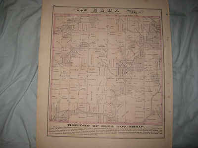
$4.00 Shipping Location: Winter Springs, United States Click Here. Double your traffic. Get Vendio Gallery- Now FREE! Fine vintage antique 1870 antique handcolored map. The map is titled. In fancy antique ... morelettering, Map of Elba Township. The map is very detailed, with named home and land owners, size of their land parcels, locatons of forests, and much more of this period. At bottom is a detailed text history related to this area as well. The map is printed on thick fine paper, with no printing on reverse Many fascianting details. The condition is just amazing, beautiful topflight condition. This is an antique map and not a reprint or reproduction. The handcoloring on the map is period to the map, this is before color printing. The map is from the very rare 1870 Andreas, Lyter& Co Atlas of Knox County Illinois. These are some of the finest producers of these antique county atlases ever, their maps and views are superb The map is a fascinating and historic period look at this area at this time. The photo wont show the true beauty of the map. The map is in nice shape and would frame and display quite beautifully. The size of the map is 14.5" by 17.5" Winning bidder pays $4.00 shipping domestic, more foreign. Payment I accept the following forms of payment: PayPal Click to View Image Album Shipping& Handling US Shipping. $4.00 USPS First-Class Mail® International Shipping. $11.50 USPS First-Class Mail International FREE scheduling. Supersized images and templates. Get Vendio Sales Manager. FREE scheduling. Supersized images and templates. Get Vendio Sales Manager.
Buy It Now
$4.00 Shipping Location: United States This is an antique map and not a reprint or reproduction. The handcoloring on the map is period to the map, this is before color printing. The map is ... morefrom the very rare Everts, Baskin and Stewart Atlas of Ogle County Illinois, produced in 1872.
Buy It Now
$3.75 Shipping Location: Winter Springs, United States The map is in superb very fine condition, any unusual shadows or fuzziness is on the photo only, not on the map. Large, superb, very fine, antique handcolored ... more1870 map, titled, in fancy antique lettering, Campbell's Topographical & Sectional Map of Fayette, Effingham and Marion Counties.
Buy It Now
$4.00 Shipping Location: United States This is an antique 1872 map and not a reprint or reproduction. The map is in excellent condition. The map is printed on thick fine paper, with no printing ... moreon reverse. This is an antique map and not a reprint or reproduction.
Buy It Now
$3.75 Shipping Location: Winter Springs, United States The map is in superb very fine condition, especially given the age of the map, just amazing condition. Printed on fine thick paper, with no printing on ... morereverse. The superb handcoloring on the map is period, this is before color printing.

Buy It Now
$4.00 Shipping Location: Winter Springs, United States Click Here. Double your traffic. Get Vendio Gallery- Now FREE! Vintage large fine antique 1892 handcolored map. The map is in gorgeous condition. The ... moremap is titled Lawrence. The maps show the named home and land owners. Size of land parcels, locations of buildings, named railroads, and much more of this period. The map is printed on thick paper, with no printing on reverse. This is an antique map and not a reprint or reproduction. The handcoloring on the map is period to the map, this is before color printing. The map is from the very rare 1892 Ogle Atlas of McHenry County Illinois. The map is a fascinating and historic period look at this area at this time. The photo wont show the full beauty of the map. The size of the map is a large 15.5" by 17.5" Winning bidder pays $4.00 shipping domestic, more foreign. Please see my eBay store for other rare maps for sale, at very reasonable prices. Payment I accept the following forms of payment: PayPal Click to View Image Album Shipping& Handling US Shipping. $4.00 USPS First-Class Mail® International Shipping. $11.50 USPS First-Class Mail International FREE scheduling. Supersized images and templates. Get Vendio Sales Manager. FREE scheduling. Supersized images and templates. Get Vendio Sales Manager.
Buy It Now
$4.00 Shipping Location: Winter Springs, United States The handcoloring on the map is beautiful, this is period to the map, before color printing. The map has a nice outside ornate border as well. Very finely ... moreproduced map, printed on thick fine paper, with no printing on reverse.
Buy It Now
$4.00 Shipping Location: Winter Springs, United States This is an antique 1872 map and not a reprint or reproduction. The map is printed on thick fine paper, with no printing on reverse. This is an antique ... moremap and not a reprint or reproduction. The handcoloring on the map is period to the map, this is before color printing.

Buy It Now
$4.00 Shipping Location: Winter Springs, United States Click Here. Double your traffic. Get Vendio Gallery- Now FREE! Vintage antique 1913.Antique handcolored map. The fine handcoloring is period to the map. ... moreThe map is titled part of the City of Champaign and Environs. The map shows named home and land owners, named additions, and much more. The map is printed on thick paper, with no printing on reverse. This is an antique map and not a reprint or reproduction. The map is from the very rare Standard Atlas of Champaign County Illinois, by George Ogle and Company, produced in 1913. The map is a fascinating and historic period look at this area at this time. The photo wont show the true beauty of the map. The size of the map is 17.5" by 30" Winning bidder pays $4.00 shipping domestic, more foreign. Payment I accept the following forms of payment: PayPal Click to View Image Album Shipping& Handling US Shipping. $4.00 USPS First-Class Mail® International Shipping. $11.50 USPS First-Class Mail International FREE scheduling. Supersized images and templates. Get Vendio Sales Manager. FREE scheduling. Supersized images and templates. Get Vendio Sales Manager.
Buy It Now
$4.00 Shipping Location: Winter Springs, United States This is an antique 1872 map and not a reprint or reproduction. The map is printed on thick fine paper, with no printing on reverse. This is an antique ... moremap and not a reprint or reproduction. The handcoloring on the map is period to the map, this is before color printing.
Buy It Now
$4.25 Shipping Location: United States No printing on reverse. Detailed and attractive period map of this area. This is an antique map and not a reprint or reproduction. The handcoloring on ... morethe map is period to the map, this is before color printing.
Buy It Now
$4.00 Shipping Location: Winter Springs, United States This is an antique 1872 map and not a reprint or reproduction. The map is printed on thick fine paper, with no printing on reverse. This is an antique ... moremap and not a reprint or reproduction. The handcoloring on the map is period to the map, this is before color printing.

Buy It Now
$4.00 Shipping Location: Winter Springs, United States Click Here. Double your traffic. Get Vendio Gallery- Now FREE! Vintage antique 1875 handcolored map. Very nicely printed on thick paper. No printing on ... moreverso. This is an antique 1875 map and not a reprint or reproduction. The superb handcoloring on the map is period,this is before color printing. The map is 2 sided, and either side would frame nicely. One side is Munson, this is Munson Township. On the map I see named home and land owners, named schools and churchs, named railroads, and much more. Verso is a nice lithograph print, showing views of Henry County Bank, Cambridge, Res of NB Gould, Cambridge, Stock farm& Res of Ehrhard Schmidt, Lynn Twp, and Stock Farm& res of GB Pillsbury, Lynn Twp. Very finely produced map, printed on thick fine paper. This is an antique map and not a reprint or reproduction. The map is from the very rare 1875 Illustrated Historical Atlas of Henry County Illinois. The map is a fascinating and historic period look at this area at this time. The photo wont show the full beauty of the map. The map is in nice shape and would frame and display quite beautifully. The size of the map is 16" by 18" Winning bidder pays $4.00 shipping domestic, more foreign. Payment I accept the following forms of payment: PayPal Click to View Image Album Click to View Image Album Shipping& Handling US Shipping. $4.00 USPS First-Class Mail® International Shipping. $11.50 USPS First-Class Mail International FREE scheduling. Supersized images and templates. Get Vendio Sales Manager. FREE scheduling. Supersized images and templates. Get Vendio Sales Manager.
Buy It Now
$4.00 Shipping Location: Winter Springs, United States This is an antique 1872 map and not a reprint or reproduction. The map is printed on thick fine paper, with no printing on reverse. This is an antique ... moremap and not a reprint or reproduction. The handcoloring on the map is period to the map, this is before color printing.

Buy It Now
$4.00 Shipping Location: Winter Springs, United States Click Here. Double your traffic. Get Vendio Gallery- Now FREE! Fine vintage antique 1870 antique handcolored map. The map is titled. In fancy antique ... morelettering, Map of Orange Township, I see many fascianting areas. The map is very detailed, with named home and land owners, size of their land parcels, locatons of forests, and much more of this period. At bottom is a detailed text history related to this area as well. The map is printed on thick fine paper, with no printing on reverse Many fascianting details. The condition is just amazing, beautiful topflight condition. This is an antique map and not a reprint or reproduction. The handcoloring on the map is period to the map, this is before color printing. The map is from the very rare 1870 Andreas, Lyter& Co Atlas of Knox County Illinois. These are some of the finest producers of these antique county atlases ever, their maps and views are superb The map is a fascinating and historic period look at this area at this time. The photo wont show the true beauty of the map. The map is in nice shape and would frame and display quite beautifully. The size of the map is 14.5" by 17.5" Winning bidder pays $4.00 shipping domestic, more foreign. Payment I accept the following forms of payment: PayPal Click to View Image Album Shipping& Handling US Shipping. $4.00 USPS First-Class Mail® International Shipping. $11.50 USPS First-Class Mail International FREE scheduling. Supersized images and templates. Get Vendio Sales Manager. FREE scheduling. Supersized images and templates. Get Vendio Sales Manager.
Buy It Now
$3.75 Shipping Location: Winter Springs, United States Beautiful map. The condition is just amazing, beautiful topflight condition. This is an antique map and not a reprint or reproduction. The handcoloring ... moreon the map is period to the map, this is before color printing.
Buy It Now
$4.00 Shipping Location: United States There is an archival tape repair towards right hand side as well. I see Polo, Buffalo and many fascianting areas and details. This is an antique map and ... morenot a reprint or reproduction. The handcoloring on the map is period to the map, this is before color printing.
Buy It Now
$4.00 Shipping Location: Winter Springs, United States This is an antique 1872 map and not a reprint or reproduction. At bottom is detailed historical text related to this area. The map is printed on thick ... morefine paper, with no printing on reverse. This is an antique map and not a reprint or reproduction.

Buy It Now
$4.00 Shipping Location: Winter Springs, United States Click Here. Double your traffic. Get Vendio Gallery- Now FREE! Vintage antique 1875 handcolored map. Very nicely printed on thick paper. No printing on ... moreverso. This is an antique 1875 map and not a reprint or reproduction. The superb handcoloring on the map is period,this is before color printing. The map is 2 sided, and either side would frame nicely. One side is Osco, this is Osco Township, On the map I see Osco, named home and land owners, named schools and churchs, named railroads, and much more, at botom is maps of Osco and Morristown. Verso is a nice lithograph print, showing views of Res of JW Arasmith, Lynn Township, Stock Farm and res of John Weidlein, Edford Twp and at bottom Stock Farm and res of NC Howard, Edford Twp. Very fine period lithography. Very finely produced map, printed on thick fine paper. This is an antique map and not a reprint or reproduction. The map is from the very rare 1875 Illustrated Historical Atlas of Henry County Illinois. The map is a fascinating and historic period look at this area at this time. The photo wont show the full beauty of the map. The map is in nice shape and would frame and display quite beautifully. The size of the map is 16" by 18" Winning bidder pays $4.00 shipping domestic, more foreign. Payment I accept the following forms of payment: PayPal Click to View Image Album Click to View Image Album Shipping& Handling US Shipping. $4.00 USPS First-Class Mail® International Shipping. $11.50 USPS First-Class Mail International FREE scheduling. Supersized images and templates. Get Vendio Sales Manager. FREE scheduling. Supersized images and templates. Get Vendio Sales Manager.
Buy It Now
$3.75 Shipping Location: United States The map is in superb very fine condition, especially given the age of the map, just amazing condition. Printed on fine thick paper, with no printing on ... morereverse. The superb handcoloring on the map is period, this is before color printing.
Buy It Now
$3.75 Shipping Location: Winter Springs, United States I see Dillon and more. The map is printed on thick fine paper. Many fascianting details. The condition is just amazing, beautiful topflight condition. ... moreThis is an antique map and not a reprint or reproduction.

Buy It Now
$4.00 Shipping Location: Winter Springs, United States Click Here. Double your traffic. Get Vendio Gallery- Now FREE! Vintage antique 1876 handcolored map. This is the finest map of this area I've ever ... moreseen. The condition is just amazing. The map is 2 sided and either side would frame and display beautifully. One side is Sheridan. This shows the period layout,named home and land owners, named railroads and much more of this period. The reverse is a gorgeous lithograph print showing 3 very fine views, top is Fair View Farm, Res of JC Bruner, Rutland Township, middle is Stock farm& Res of LD Aldrich, Mendota Twp, and bottom is Res of George Johnson, 1/2 Mile West of Mendota Very finely printed on thick paper, no printing on verso. This is an antique 1876 map and not a reprint or reproduction. The superb handcoloring on the map is period,this is before color printing. Very finely produced map, printed on thick fine paper. This is an antique map and not a reprint or reproduction. The map is from the very rare 1876 Warner& beers Atlas of La Salle County Illinois. The map is a fascinating and historic period look at this area at this time. The photo wont show the full beauty of the map. The map is in nice shape and would frame and display quite beautifully. The size of the map is 15.5' by 18.5" Winning bidder pays $4.00 shipping domestic, more foreign. Payment I accept the following forms of payment: PayPal Click to View Image Album Click to View Image Album Shipping& Handling US Shipping. $4.00 USPS First-Class Mail® International Shipping. $11.50 USPS First-Class Mail International FREE scheduling. Supersized images and templates. Get Vendio Sales Manager. FREE scheduling. Supersized images and templates. Get Vendio Sales Manager.
Buy It Now
$4.00 Shipping Location: Winter Springs, United States This is an antique 1872 map and not a reprint or reproduction. The map is printed on thick fine paper, with no printing on reverse. This is an antique ... moremap and not a reprint or reproduction. The handcoloring on the map is period to the map, this is before color printing.
Buy It Now
$3.75 Shipping Location: Winter Springs, United States The map is printed on thick fine paper. Many fascianting details. The condition is just amazing, beautiful topflight condition. This is an antique map ... moreand not a reprint or reproduction. The handcoloring on the map is period to the map, this is before color printing.
Buy It Now
$4.00 Shipping Location: Winter Springs, United States Of Clark & Adams Sts. Warner and Beers were highly regarded mapmakers of this period. Very finely produced map, printed on thick fine paper, with fine ... moreoutside border as well, no printing on verso. The superb and attractive handcoloring is period to the map, this is before color printing.
Buy It Now
$3.75 Shipping Location: Winter Springs, United States I see Tremont and more. There is detailed historical text related to this area at bottom as well. The map is printed on thick fine paper, with no printing ... moreon reverese. Many fascianting details. The condition is just amazing, beautiful topflight condition.

Buy It Now
Free Shipping Location: Winter Springs, United States Click Here. Double your traffic. Get Vendio Gallery- Now FREE! Vintage antique 1929.Antique handcolored map. The fine handcoloring is period to the map. ... moreThe map is 4 pages and any side would frame and display quite nicely, the first and last page are not handcolored, the first page is Map of Groveland Township, the next 2 pages is a fine antique handcolored map titled West Part of Marseilles, Rutland and Manlius Township, and the last page is Map of Osage Twp. Fine outside ornate border as well. Many fascianting areas, very detailed. The gorgeous handcoloring is period to the map. The map shows named home and land owners, named additions, and much more. The map is printed on thick paper, with no printing on reverse. This is an antique map and not a reprint or reproduction. The map is from the very rare Standard Atlas of Champaign County Illinois, by Brock and Company, produced in 1929. The map is a fascinating and historic period look at this area at this time. The photo wont show the true beauty of the map. The size of the single page map is 15" by 17.5" and the 2 page map is 17.5" by 30" Winning bidder pays $4.00 shipping domestic, more foreign. Payment I accept the following forms of payment: PayPal Click to View Image Album Click to View Image Album Click to View Image Album Shipping& Handling US Shipping. $4.00 USPS First-Class Mail® International Shipping. $11.50 USPS First-Class Mail International FREE scheduling. Supersized images and templates. Get Vendio Sales Manager. FREE scheduling. Supersized images and templates. Get Vendio Sales Manager.
Buy It Now
$3.75 Shipping Location: Winter Springs, United States I see many Pekin and fascianting areas. At right are superb lithograph print views, with View of the Delavan City Mills, Starz & Lux, Proprietors, delavan, ... moreIll. Tazewell County Court House, Pekin, Ills.
Buy It Now
$4.00 Shipping Location: United States This is an antique 1872 map and not a reprint or reproduction. The map is in excellent condition, printed on thick paper, with no printing on verso.This ... moreis an antique map and not a reprint or reproduction.
Buy It Now
$3.75 Shipping Location: Winter Springs, United States Very nicely printed on thick paper, no printing on verso. This is an antique 1875 map and not a reprint or reproduction. The superb handcoloring on the ... moremap is period,this is before color printing. This is an antique map and not a reprint or reproduction.
Buy It Now
$3.50 Shipping Location: Winter Springs, United States The linenbacking really protected the map. I see Beverly and much more. I many interresting areas, a very attractive map, showing trees, churches, and ... moremuch more. At bottom is detailed text in regards to this area as well.

Buy It Now
$4.00 Shipping Location: Winter Springs, United States Click Here. Double your traffic. Get Vendio Gallery- Now FREE! Vintage antique 1874 handcolored map. The map is titled Township 1 South. Range 6 West ... moreof the 3rd Principal Meridian, I believe this is New Athens Township, I se Pensoneau Station and much more, this map shows the named home and land owners, named railroads, and much more of this period. Printed on thick paper, and is overall in gorgeous condition. The superb handcoloring on the map is period, this is before color printing. This is an antique map and not a reprint or reproduction. The map is from the very rare 1874 Warner and Beers Atlas of St. Clair County Illinois. The map is a fascinating and historic period look at this area at this time. The photo wont show the full beauty of the map. The map is in nice shape and would frame and display quite beautifully. The size of the map is 14.5" by 17.5" Winning bidder pays $3.75 shipping domestic, more foreign. Payment I accept the following forms of payment: PayPal Click to View Image Album Shipping& Handling US Shipping. $4.00 USPS First-Class Mail® International Shipping. $11.50 USPS First-Class Mail International FREE scheduling. Supersized images and templates. Get Vendio Sales Manager. FREE scheduling. Supersized images and templates. Get Vendio Sales Manager.
Buy It Now
$3.75 Shipping Location: Winter Springs, United States The map is printed on thick fine paper, with no printing on reverese. The condition is just amazing, beautiful topflight condition. This is an antique ... moremap and not a reprint or reproduction. The handcoloring on the map is period to the map, this is before color printing.

Buy It Now
$4.00 Shipping Location: Winter Springs, United States Click Here. Double your traffic. Get Vendio Gallery- Now FREE! Vintage antique 1875 handcolored map. Very nicely printed on thick paper. This is an antique ... more1875 map and not a reprint or reproduction. The superb handcoloring on the map is period. This is before color printing. The map is 2 sided and either side would frame and display quite nicely. The map is in gorgeous, very superb condition. The map is titled, in fancy antique lettering Annawan, Nekomia, Bishop Hill and Andover. The map shows the named home and land owners, named railroads, locations of buildings, and much more. Reverse is a gorgeous lithograph print showing Res of FA Hurlburtt, Galva, and Stock Farm of Capt Peter Wickstrum, Galva Twp. Beautifully detailed period map of these areas at this time. Warner and Beers were very highly regarded mapmakers of this period. The map is printed on fine thick paper, with no printing on reverse, fine outside ornate border as well. This is an antique map and not a reprint or reproduction. The map is from the very rare 1875 Illustrated Historical Atlas of Henry County Illinois. The map is a fascinating and historic period look at this area at this time. The photo wont show the full beauty of the map. The map is in nice shape and would frame and display quite beautifully. The size of the map is 16" by 18" Winning bidder pays $4.00 shipping domestic, more foreign. Payment I accept the following forms of payment: PayPal Click to View Image Album Click to View Image Album Shipping& Handling US Shipping. $4.00 USPS First-Class Mail® International Shipping. $11.50 USPS First-Class Mail International FREE scheduling. Supersized images and templates. Get Vendio Sales Manager. FREE scheduling. Supersized images and templates. Get Vendio Sales Manager.
Buy It Now
$4.00 Shipping Location: Winter Springs, United States This is an antique 1872 map and not a reprint or reproduction. The map is printed on thick fine paper, with no printing on reverse. This is an antique ... moremap and not a reprint or reproduction. The handcoloring on the map is period to the map, this is before color printing.
Buy It Now
$3.75 Shipping Location: Winter Springs, United States The map is printed on thick fine paper. Many fascianting details. The condition is just amazing, beautiful topflight condition. This is an antique map ... moreand not a reprint or reproduction. The handcoloring on the map is period to the map, this is before color printing.
Buy It Now
$4.00 Shipping Location: United States This is an antique 1872 map and not a reprint or reproduction. The map is in excellent condition. The map is printed on thick fine paper, with no printing ... moreon reverse. This is an antique map and not a reprint or reproduction.
|
|
|
In
|
HUGE ANTIQUE 1913 MATTOON EAST PART COLES COUNTY ILLINOIS HANDCOLORED MAP NR
Click Here. Double your traffic. Get Vendio Gallery- Now FREE! Vintage 1913 antique handcolored map. The fine handcoloring is period to the map. The map is titled. In fancy antique lettering East Part of Mattoon, with 1913 copyright to Geo. A. Ogle& Co. below the title, this dates the map nicely. The map has some a small bit of loss at extreme right hand side middle. The map shows the period named home and land owners, named railroads, size of land parcels, locations of buildings and much more. The map is printed on thick paper, with no printing on reverse. Nice outside ornate border as well. This is an antique map and not a reprint or reproduction. The map is from the very rare Standard Atlas of Coles County Illinois, by George Ogle and Company, produced in 1913. The map is a fascinating and historic period look at this area at this ... moretime. The photo wont show the true beauty of the map. The size of the map is 17.5" by 29" Winning bidder pays $3.75 shipping domestic, more foreign. Payment I accept the following forms of payment: PayPal Click to View Image Album Shipping& Handling US Shipping. $3.75 USPS First-Class Mail® International Shipping. $11.50 USPS First-Class Mail International FREE scheduling. Supersized images and templates. Get Vendio Sales Manager. FREE scheduling. Supersized images and templates. Get Vendio Sales Manager.
|
|
 |