-
Christian Collectibles
-
Christian Sheet Music
-
Vatican Stamps
-
Vatican Coins & Paper Money
-
Antiques
-
Antiquities
-
Architectural & Garden
-
Decorative Arts
-
Ethnographic
-
Furniture
-
Maps, Atlases & Globes
-
United States (Pre-1900)
-
United States (1900-Now)
-
AK, HI
-
AL, FL, GA, MS, NC, SC
-
AR, IA, KS, LA, MO, NE
-
AZ, CA, CO, NM, NV, UT
-
CT, MA, ME, NH, RI, VT
-
DC, DE, MD, NJ, NY, PA
-
ID, OR, WA
-
IL, IN, MI, OH, WI
-
MN, MT, ND, SD, WY
-
OK, TX
-
VA, WV, KY, TN
-
Entire US
-
United States (Date Unknown)
-
Africa
-
Asia
-
Australasia/ Oceania
-
Canada
-
Central America/ Caribbean
-
Europe
-
India
-
Ireland
-
Mexico
-
Middle East
-
North America
-
South America
-
United Kingdom
-
Maps on CD
-
World Maps
-
Globes
-
Mixed Lots
-
Reproductions
-
Price Guides & Publications
-
Other
|
In
Order by: Available to: This site contains affiliate links for which I may be compensated
|
Buy It Now
$4.50 Shipping Location: United States The map shows Outline Map of Huron Co. Ohio, titled in fancy antique lettering. Nice outside ornate border. This is an antique map and not a reprint or ... morereproduction. The handcoloring on the map is period to the map, this is before color printing.
Buy It Now
$4.50 Shipping Location: United States The map is titled City of Toledo, Part Five. Print on thick paper. The map is printed on thick paper, with no printing on reverse. Many fascianting areas ... moreon the map. The map is from the very rare 1875 Andreas and Baskin Atlas of Lucas and Wood County Ohio.

Buy It Now
$3.75 Shipping Location: Winter Springs, United States Click Here. Double your traffic. Get Vendio Gallery- Now FREE! Vintage antique 1874 handcolored map. The map is titled. In fancy antique lettering, Troy, ... morethis is Troy Township, I see Troy, Nova PO, and at left an inset map of Rowsburg, Perry Township. The map shows the named land and home owners, named business and industry, named railroads, locations of buildings, and much more. The map is printed on thick paper, with no printing on reverse. The condition of the map is nice. This is an antique map and not a reprint or reproduction. The handcoloring on the map is period to the map, this is before color printing, the map is printed on thick paper, with no printing on reverse. The map is from the very rare 1874 J.A. Caldwell Atlas of Ashland County Ohio. The map is a fascinating and historic period look at this area at this time. The photo wont show the full beauty of the map. The size of the map is 14" by 17" Winning bidder pays $3.75 shipping domestic, more foreign. Payment I accept the following forms of payment: PayPal Click to View Image Album Shipping& Handling US Shipping. $3.75 USPS First-Class Mail® International Shipping. $11.50 USPS First-Class Mail International FREE scheduling. Supersized images and templates. Get Vendio Sales Manager. FREE scheduling. Supersized images and templates. Get Vendio Sales Manager. RcmdId ViewItemDescV4,RlogId p4%60bo7%60jtb9%3Fvo%7B%3Dd70f%2Bf%60%60%3E-144bdd5519d-0x108-
Buy It Now
$4.00 Shipping Location: United States The map shows Orange city. The map is printed on thick paper, with no printing on reverse. The condition of the map is nice. This is an antique map and ... morenot a reprint or reproduction. The handcoloring on the map is period to the map, this is before color printing, the map is printed on thick paper, with no printing on reverse.
Buy It Now
$4.00 Shipping Location: United States The next 2 pages is a large and amazing antique handcolored map titled, in fancy antique lettering, Fourth Ward of Massillon, and also Second Ward. This ... moreis an antique map and not a reprint or reproduction.

Buy It Now
$3.75 Shipping Location: Winter Springs, United States Click Here. Double your traffic. Get Vendio Gallery- Now FREE! Superb. Large antique 1902 handcolored map. The map is titled Part of Sale, the map shows ... morethe named land owners, named streets, named railroads, and much more. This is an antique from 1902, and is not a reprint or reproduction. The beautiful handcoloring on the map is period, this is before color printing was invented. The size of the map is 15.5" by 19" large and impressive. This would frame and display quite nicely. The map is in excellent condition. The map is from the rare 1902 Atlas of Columbiana County Ohio. The maps were produced by AH Mueller, one of the finest mapmakers of this period. Many fascinating period detials related to these areas in 1902. Winning bidder pays $3.75 shipping domestic, $7.00 foreign airmail. Payment I accept the following forms of payment: PayPal Click to View Image Album Shipping& Handling US Shipping. $3.75 USPS First-Class Mail® International Shipping. $7.00 USPS First-Class Mail International FREE scheduling. Supersized images and templates. Get Vendio Sales Manager. FREE scheduling. Supersized images and templates. Get Vendio Sales Manager.

Buy It Now
$3.75 Shipping Location: Winter Springs, United States Click Here. Double your traffic. Get Vendio Gallery- Now FREE! Superb. Large antique 1902 handcolored map. The map is titled Part of Salem, the map shows ... morethe named land owners, named streets, named railroads, and much more. This is an antique from 1902, and is not a reprint or reproduction. The beautiful handcoloring on the map is period, this is before color printing was invented. The size of the map is 15.5" by 19" large and impressive. This would frame and display quite nicely. The map is in excellent condition. The map is from the rare 1902 Atlas of Columbiana County Ohio. The maps were produced by AH Mueller, one of the finest mapmakers of this period. Many fascinating period detials related to these areas in 1902. Winning bidder pays $3.75 shipping domestic, $7.00 foreign airmail. Payment I accept the following forms of payment: PayPal Click to View Image Album Shipping& Handling US Shipping. $3.75 USPS First-Class Mail® International Shipping. $7.00 USPS First-Class Mail International FREE scheduling. Supersized images and templates. Get Vendio Sales Manager. FREE scheduling. Supersized images and templates. Get Vendio Sales Manager.

Buy It Now
$3.75 Shipping Location: Winter Springs, United States Click Here. Double your traffic. Get Vendio Gallery- Now FREE! Fine large antique handcolored map. Titled Lorain City, South Central Part. The map shows ... morethe home and land owners, districts, tracts, named railroads and much more. This is an antique map and not a reprint or reproduction. Fine period handcoloring, nice outside ornate border, printed on thick paper, with no printing on reverse. The map is from the very rare 1896 American Atlas of Lorain County Ohio. The map is a fascinating and historic period look at this area at this time. The map shows the home and land owners, railroads, and much more. The photo wont show the full beauty of the map. The map is in nice shape, tight and clean. The size of the map is 18.5" by 29.5" Winning bidder pays $3.75 shipping domestic, more foreign. Payment I accept the following forms of payment: PayPal Click to View Image Album Shipping& Handling US Shipping. $3.75 USPS First-Class Mail® International Shipping. $11.50 USPS First-Class Mail International FREE scheduling. Supersized images and templates. Get Vendio Sales Manager. FREE scheduling. Supersized images and templates. Get Vendio Sales Manager.
Buy It Now
$3.75 Shipping Location: Winter Springs, United States Gorgeous, antique 1875 handcolored map, large folding map, the bottom portion is lost, but the remaining part is very interesting. Printed upper left ... morehand side is Population of Ohio By Counties 1870.

Buy It Now
$4.00 Shipping Location: United States Click Here. Double your traffic. Get Vendio Gallery- Now FREE! Vintage antique 1875 handcolored map. The map is printed on 1 side only. With no printing ... moreon reverse, the map is titled Third ward of Massillon. The mapis huge. There is a bit of clean inside seperation along the top middle fold, if framed would be fine. the map is quite detailed with the named home and land owners, location of buildings, named railroads and much more. Overall in very nice condition. The last page is a beautiful lithograph print page showing Res of Gen. Kent Jarvis, Jarvis Block and res of Harmon Shrive, all Massillon. This is an antique map and not a reprint or reproduction. The handcoloring on the map is period to the map, this is before color printing. The map is from the very rare 1875 Everts Atlas of Stark County Ohio. The map is a fascinating and historic period look at this area at this time. The photo wont show the full beauty of the map. The map is in nice shape,tight and clean. The size of the map is 21" by 27" Winning bidder pays $4.00 shipping domestic, more foreign. Payment I accept the following forms of payment: PayPal Click to View Image Album Shipping& Handling US Shipping. $4.00 USPS First-Class Mail® International Shipping. $11.50 USPS First-Class Mail International FREE scheduling. Supersized images and templates. Get Vendio Sales Manager. FREE scheduling. Supersized images and templates. Get Vendio Sales Manager. RcmdId ViewItemDescV4,RlogId p4%60bo7%60jtb9%3Fuk.rp*0a6211%3E-13d5a155cb7-0xf8-
Buy It Now
$4.00 Shipping Location: United States Superb, large antique 1902 handcolored map. The map is titled, in fancy antique lettering Part of East Palestine. With detailed Reference chart corresponding ... moreto the map itself. The map is in nice condition.
Buy It Now
$4.00 Shipping Location: Winter Springs, United States The map is printed on very thick paper, the gorgeous handcoloring is period to the map. The map is from the rare 1875 L. H. Everts Atlas of Licking County ... moreOhio. The size of the map is 14" by 17". FREE scheduling, supersized images.

Buy It Now
$3.75 Shipping Location: Winter Springs, United States Click Here. Double your traffic. Get Vendio Gallery- Now FREE! Vintage antique 1875 handcolored map. The map is 2 sided and either side would frame and ... moredisplay nicely. One side is Map of Lordstown Township. I see many fascianting areas. The map shows the named home and land owners, the business and industry, the few roads, railroads etc that existed at that time. Verso is a superb lithograph print page, showing superb period views, they are Res of Aaron davis, bazetta Twp, Res of WW Post, Crotland, Bazetta Township, and Oakdale Farm, Bazetta Twp. This is an antique map and not a reprint or reproduction. The handcoloring on the map is period to the map, this is before color printing. The map is from the very rare 1875 Everts Atlas of Trumbull County Ohio. The map is a fascinating and historic period look at this area at this time. The photo wont show the full beauty of the map. The map is in nice shape,tight and clean. The size of the map is 14" by 17" Winning bidder pays $3.75 shipping domestic, more foreign. Payment I accept the following forms of payment: PayPal Click to View Image Album Click to View Image Album Shipping& Handling US Shipping. $3.75 USPS First-Class Mail® International Shipping. $11.50 USPS First-Class Mail International FREE scheduling. Supersized images and templates. Get Vendio Sales Manager. FREE scheduling. Supersized images and templates. Get Vendio Sales Manager.
Buy It Now
$3.75 Shipping Location: United States Superb, large antique 1902 handcolored map. The map is printed on thick paper, with no printing on reverse. This is an antique from 1902, and is not a ... morereprint or reproduction. The size of the map is 15.5" by 19", large and impressive.
Buy It Now
$3.75 Shipping Location: Winter Springs, United States The map shows Orange city. The map is printed on thick paper, with no printing on reverse. The condition of the map is nice. This is an antique map and ... morenot a reprint or reproduction. The handcoloring on the map is period to the map, this is before color printing, the map is printed on thick paper, with no printing on reverse.

Buy It Now
$3.75 Shipping Location: Winter Springs, United States Click Here. Double your traffic. Get Vendio Gallery- Now FREE! Superb. Large antique 1902 handcolored map. The map is titled Part of Salem, with inset ... moremap of Hillsdale, Schillings Addition to Salem, the map shows the named land owners, named streets, named railroads, and much more. This is an antique from 1902, and is not a reprint or reproduction. The beautiful handcoloring on the map is period, this is before color printing was invented. The size of the map is 15.5" by 19" large and impressive. This would frame and display quite nicely. The map is in excellent condition. The map is from the rare 1902 Atlas of Columbiana County Ohio. The maps were produced by AH Mueller, one of the finest mapmakers of this period. Many fascinating period detials related to these areas in 1902. Winning bidder pays $3.75 shipping domestic, $7.00 foreign airmail. Payment I accept the following forms of payment: PayPal Click to View Image Album Shipping& Handling US Shipping. $3.75 USPS First-Class Mail® International Shipping. $7.00 USPS First-Class Mail International FREE scheduling. Supersized images and templates. Get Vendio Sales Manager. FREE scheduling. Supersized images and templates. Get Vendio Sales Manager.
Buy It Now
$4.00 Shipping Location: Winter Springs, United States The conditon on this 1874 antique handcolored map is amazing. Reverse is a gorgeous lithograph print,very fine superb period lithography, with Res of ... moreCollin Freeman, Granger Twp, Res of Tillman Koons, Spencer Twp, Res of Sh Albertson, MD, Granger Twp, Res of Daniel Fluent, Granger Twp, res of AA Witbeck, Spencer Twp and Res of CW Aldrich, Spencer.
Buy It Now
$3.75 Shipping Location: United States Superb, antique 1875 handcolored map. The map is printed on very thick paper, with no printing on reverse. Fascianting and detailed period map of Darke ... moreCounty in 1875. This is an antique from 1875, and is not a reprint or reproduction.
Buy It Now
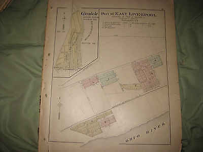
$3.75 Shipping Location: Winter Springs, United States Click Here. Double your traffic. Get Vendio Gallery- Now FREE! Superb. Large antique 1902 handcolored map. The map is titled Part of East Liverpool, with ... moreinset map titledGlendale, Liverpool Twp. The map shows the named land owners, named railroads, amount of acreage owned and more. The map has 2 small clean tears at extreme right hand side, if framed would be fine. The map is printed on thick paper, with no printing on reverse. This is an antique from 1902, and is not a reprint or reproduction. The beautiful handcoloring on the map is period, this is before color printing was invented. The size of the map is 15.5" by 19" large and impressive. This would frame and display quite nicely. The map is in excellent condition. The map is from the rare 1902 Atlas of Columbiana County Ohio. The maps were produced by AH Mueller, one of the finest mapmakers of this period. Many fascinating period detials related to these areas in 1902. Winning bidder pays $3.75 shipping domestic, more foreign. Payment I accept the following forms of payment: PayPal Click to View Image Album Shipping& Handling US Shipping. $3.75 USPS First-Class Mail® International Shipping. $11.50 USPS First-Class Mail International FREE scheduling. Supersized images and templates. Get Vendio Sales Manager. FREE scheduling. Supersized images and templates. Get Vendio Sales Manager.
Buy It Now
$4.50 Shipping Location: United States The map is titled City of Toledo, Part Two. Print on thick paper. The map is printed on thick paper, with no printing on reverse. Many fascianting areas ... moreon the map. The map is from the very rare 1875 Andreas and Baskin Atlas of Lucas and Wood County Ohio.

Buy It Now
$3.75 Shipping Location: Winter Springs, United States Click Here. Double your traffic. Get Vendio Gallery- Now FREE! Vintage antique 1876 handcolored map. The map is titled. In fancy antique lettering, Map ... moreof Milford Township, I see many fascianting areas. The map shows the named home and land owners, the few roads, the locations of buildings, and much ore of this period. Printed on thick fine paper. This is an antique map and not a reprint or reproduction. The handcoloring on the map is period to the map, this is before color printing. The map is from the very rare 1876 Hardesty Atlas of Defiance County Ohio. The map is a fascinating and historic period look at this area at this time. The photo wont show the full beauty of the map. The size of the map is large 14" by 19.5" Winning bidder pays $3.75 shipping domestic, more foreign. Payment I accept the following forms of payment: PayPal Click to View Image Album Shipping& Handling US Shipping. $3.75 USPS First-Class Mail® International Shipping. $11.50 USPS First-Class Mail International FREE scheduling. Supersized images and templates. Get Vendio Sales Manager. FREE scheduling. Supersized images and templates. Get Vendio Sales Manager.

Buy It Now
$3.75 Shipping Location: Winter Springs, United States Click Here. Double your traffic. Get Vendio Gallery- Now FREE! Superb. Antique 1875 handcolored map. The map shows Patterson Township, I see Woodland, ... moreand inset map of Woodland as well, the named home and land owners, locations of buildings, the railroads, the roads, and much more of this period. The map has 1 piece of tape at upper right hand side. Fascianting and detailed period map of Darke County in 1875. Fascinating period map, shows the home and land owners, period roads, railroads, business and industry and much more. This is an antique from 1875, and is not a reprint or reproduction. The beautiful handcoloring on the map is period, this is before color printing was invented. The size of the map is 14" by 16" This would frame and display quite nicely. The map is in nice condition, and would frame and display beautifully. The map is from the rare 1875 Lake, Griffing and Stevenson Atlas of Darke County Ohio. Many fascinating period detials related to these areas in 1875. Winning bidder pays $3.75 shipping domestic, more foreign airmail. Payment I accept the following forms of payment: PayPal Click to View Image Album Shipping& Handling US Shipping. $3.75 USPS First-Class Mail® International Shipping. $11.50 USPS First-Class Mail International FREE scheduling. Supersized images and templates. Get Vendio Sales Manager. FREE scheduling. Supersized images and templates. Get Vendio Sales Manager.
Buy It Now
$3.75 Shipping Location: Winter Springs, United States ANY UNUSUAL SHADOWS OR FUZZINESS IS ON THE PHOTO ONLY, THE MAP IS IN BEAUTIFUL CONDITON. Fine antique color handcolored map, the Map is titled Part of ... moreCity of Elyria. Very detailed, Imany fascianting areas.
Buy It Now
$4.00 Shipping Location: United States The map has a piece missing at lower left hand side. Printed on thick paper, with no printing on reverse. This is an antique map and not a reprint or ... morereproduction. The handcoloring on the map is period to the map, this is before color printing.
Buy It Now
$4.50 Shipping Location: United States The fmap is titled City of Toledo, Part Ten. Print on thick paper, with no printing on reverse. The map is printed on thick paper, with no printing on ... morereverse. Many fascianting areas on the map. The map is from the very rare 1875 Andreas and Baskin Atlas of Lucas and Wood County Ohio.
Buy It Now
$3.75 Shipping Location: Winter Springs, United States Very finely produced, beautiful period handcoloring, printed on thick fine paper, and the conditon is excellent, no printing on reverse. The map is titled ... moreNorth Part of Lima. The map is in excellent beautiful condition.

Buy It Now
$4.00 Shipping Location: Winter Springs, United States Click Here. Double your traffic. Get Vendio Gallery- Now FREE! Vintage antique 1871 handcolored map. This is titled Lincoln. This is Lincoln Township, ... moreI see many fascianting areas, the map is very detailed showing the named home and land owners, named railroads, locations of buildings and much more. Nice outside ornate border as well. The map is printed on thick paper with no printing on reverse. The condition of the map is very nice. This is an antique map and not a reprint or reproduction. The handcoloring on the map is period to the map, this is before color printing. The map is from the very rare 1871 Titus Atlas of Miami County Ohio. The map is a fascinating and historic period look at this area at this time. The photo wont show the full beauty of the map. The size of the map is 12.5" by 15.5" Winning bidder pays $4.00 shipping domestic, more foreign. Payment I accept the following forms of payment: PayPal Click to View Image Album Shipping& Handling US Shipping. $4.00 USPS First-Class Mail® International Shipping. $11.50 USPS First-Class Mail International FREE scheduling. Supersized images and templates. Get Vendio Sales Manager. FREE scheduling. Supersized images and templates. Get Vendio Sales Manager. ec2.RcmdId ViewItemDescV4,RlogId p4%60bo7%60jtb9%3Fvo%7B%3Dd70f%2B%3Eec2-145da7ef990-0x109-
Buy It Now
$4.00 Shipping Location: Winter Springs, United States The condition of the map is amazing, really nice. This is an antique map and not a reprint or reproduction. The superb handcoloring is period to the map, ... morethis before color printing. I see Chandlersville and more.
Buy It Now
$4.00 Shipping Location: Winter Springs, United States The map is printed on thick paper, with no printing on reverse. Many fascinating areas on the map, superb antique map. This is an antique map and not ... morea reprint or reproduction. The handcoloring on the map is period to the map, this is before color printing.
Buy It Now
$4.00 Shipping Location: United States The map is dated 1870 in several areas. The map has wear, tears, and the lower right hand side piece is seperated. Still a fascianting study map and could ... morebe repaired as well. Printed on fine paper with no printing on reverse.

Buy It Now
$3.75 Shipping Location: Winter Springs, United States Click Here. Double your traffic. Get Vendio Gallery- Now FREE! Superb. Large antique 1902 handcolored map. The map is titled Washingtonville, with inset ... moremap of Highlandtown, the map shows the named home and land owners, named streets, named railroads, and much more. The map is printed on thick paper, with no printing on reverse. The map has a clean tar at lower right, neatly repaired on reverse with archival tape. This is an antique from 1902, and is not a reprint or reproduction. The beautiful handcoloring on the map is period, this is before color printing was invented. The size of the map is 15.5" by 19" large and impressive. This would frame and display quite nicely. The map is in excellent condition. The map is from the rare 1902 Atlas of Columbiana County Ohio. The maps were produced by AH Mueller, one of the finest mapmakers of this period. Many fascinating period details related to these areas in 1902. Winning bidder pays $3.75 shipping domestic, more foreign. Payment I accept the following forms of payment: PayPal Click to View Image Album Shipping& Handling US Shipping. $3.75 USPS First-Class Mail® International Shipping. $11.50 USPS First-Class Mail International FREE scheduling. Supersized images and templates. Get Vendio Sales Manager. FREE scheduling. Supersized images and templates. Get Vendio Sales Manager. RcmdId ViewItemDescV4,RlogId p4%60bo7%60jtb9%3Feog4d72f%2Bf7%60%3E-13ebab60cab-0x102-
Buy It Now
$3.75 Shipping Location: United States I see Cedarville and more. Mostly in the middle and a few other areas. I did not do the tape repairs and this is how I receieved the map. This is an antique ... moremap and not a reprint or reproduction. The handcoloring on the map is period to the map, this is before color printing.
Buy It Now
$4.00 Shipping Location: Winter Springs, United States Superb, antique 1890 handcolored map. The condition of the map is amazing, esp. given the age of the map. The map is printed on thick paper, with no printing ... moreon reverse. This is an antique from 1890, and is not a reprint or reproduction.
Buy It Now
$4.00 Shipping Location: United States Printed on thick paper, with no printing on reverse. The condition of the map is amazing. Nice outside ornate border as well. This is an antique map and ... morenot a reprint or reproduction. The handcoloring on the map is period to the map, this is before color printing.

Buy It Now
$3.75 Shipping Location: Winter Springs, United States Click Here. Double your traffic. Get Vendio Gallery- Now FREE! Vintage antique 1870 handcolored map. This is titled Neville. Washington Township, Woodvile, ... moreWayne Township and Marathon, Jackson Township. The map shows the named home and land owners, named streets, named business and industry, size and locations of buildings, and much more of this period. The map is printed on thick paper with no printing on reverse. The condition of the map is amazing. This is an antique map and not a reprint or reproduction. The handcoloring on the map is period to the map, this is before color printing. The map is from the very rare 1870 Titus Atlas of Clermont County Ohio. The map is a fascinating and historic period look at this area at this time. The photo wont show the full beauty of the map. The size of the map is 12.5" by 15" Winning bidder pays $3.75 shipping domestic, more foreign. Payment I accept the following forms of payment: PayPal Click to View Image Album Shipping& Handling US Shipping. $3.75 USPS First-Class Mail® International Shipping. $11.50 USPS First-Class Mail International FREE scheduling. Supersized images and templates. Get Vendio Sales Manager. FREE scheduling. Supersized images and templates. Get Vendio Sales Manager.

Buy It Now
$3.75 Shipping Location: Winter Springs, United States Click Here. Double your traffic. Get Vendio Gallery- Now FREE! Vintage fine antique 1892 handcolored map. The map is 2 sided. One side is Latty Township, ... morereverse is Emerald Township. The map shows how these areas looked in 1892, with named land owners, period layout, named railroads and much more of this period, fascianting period map. Nice outside ornate border as well. The map is printed on thick paper. This is an antique map and not a reprint or reproduction. The handcoloring on the map is period to the map, this is before color printing. The map is from the very rare 1892 Western Publishing Company Atlas of Paulding County Ohio. The map is a fascinating and historic period look at this area at this time. The photo wont show the full beauty of the map. The size of the map is 18" by 29" Winning bidder pays $3.75 shipping domestic, more foreign. Please see my eBay store for other rare maps for sale, at very reasonable prices. Payment I accept the following forms of payment: PayPal Click to View Image Album Click to View Image Album Shipping& Handling US Shipping. $3.75 USPS First-Class Mail® International Shipping. $11.50 USPS First-Class Mail International FREE scheduling. Supersized images and templates. Get Vendio Sales Manager. FREE scheduling. Supersized images and templates. Get Vendio Sales Manager.
Buy It Now
$4.00 Shipping Location: United States I see many fascinating areas. The map is printed on thick paper, with no printing on reverse. The condition of the map is nice. This is an antique map ... moreand not a reprint or reproduction. The handcoloring on the map is period to the map, this is before color printing, the map is printed on thick paper, with no printing on reverse.
Buy It Now
$3.75 Shipping Location: Winter Springs, United States The map is printed on thick paper, with no printing on reverse. The condition of the map is excellent. This is an antique map and not a reprint or reproduction. ... moreThe handcoloring on the map is period to the map, this is before color printing, the map is printed on thick paper, with no printing on reverse.
Buy It Now
$4.00 Shipping Location: United States Superb, large antique 1902 handcolored map. The map is titled Part of Wellsville. The map is in nice condition. The map is printed on thick paper, with ... moreno printing on reverse. This is an antique from 1902, and is not a reprint or reproduction.

Buy It Now
$3.75 Shipping Location: Winter Springs, United States Click Here. Double your traffic. Get Vendio Gallery- Now FREE! Superb. Large antique 1902 handcolored map. The map is titled part of Columbiana, the map ... moreshows the namd land owners, period layout and much more, very detailed. The map shows the named land owners and more. The map is printed on thick paper, with no printing on reverse. This is an antique from 1902, and is not a reprint or reproduction. The beautiful handcoloring on the map is period, this is before color printing was invented. The size of the map is 15.5" by 19" large and impressive. This would frame and display quite nicely. The map is in excellent condition. The map is from the rare 1902 Atlas of Columbiana County Ohio. The maps were produced by AH Mueller, one of the finest mapmakers of this period. Many fascinating period detials related to these areas in 1902. Winning bidder pays $3.75 shipping domestic, $7.00 foreign airmail. Payment I accept the following forms of payment: PayPal Click to View Image Album Shipping& Handling US Shipping. $3.75 USPS First-Class Mail® International Shipping. $7.00 USPS First-Class Mail International FREE scheduling. Supersized images and templates. Get Vendio Sales Manager. FREE scheduling. Supersized images and templates. Get Vendio Sales Manager.
Buy It Now
$3.75 Shipping Location: Winter Springs, United States The map is titled Batavia, the map had a large tear across it, but I neatly repaired with archival tape on reverse. The map is in nice condition. This ... moreis an antique map and not a reprint or reproduction, printed on thick paper, no printing on reverse.
Buy It Now
$3.75 Shipping Location: United States Superb, antique 1875 handcolored map. This is an antique from 1875, and is not a reprint or reproduction. The size of the map is 14" by 16". The map is ... morefrom the rare 1875 Lake, Griffing and Stevenson Atlas of Darke County Ohio.
Buy It Now
$3.75 Shipping Location: Winter Springs, United States The gorgeous handcoloring is period to the map, this is before color printing. Printed on thick paper, with no printing on reverse. This is an antique ... moremap and not a reprint or reproduction. The handcoloring on the map is period to the map, this is before color printing.
Buy It Now
$4.00 Shipping Location: Winter Springs, United States The map is printed on thick paper, with no printing on reverse. Many fascinating areas on the map, superb antique map. This is an antique map and not ... morea reprint or reproduction. The handcoloring on the map is period to the map, this is before color printing.
Buy It Now
$3.75 Shipping Location: Winter Springs, United States Very finely produced, beautiful period handcoloring, printed on thick fine paper, and the conditon is excellent, no printing on reverse. The map is titled ... moreOttawa. The map is in excellent beautiful conditon.
Buy It Now
$4.00 Shipping Location: United States Superb, large antique 1902 handcolored map. The map is printed on thick paper, with no printing on reverse. This is an antique from 1902, and is not a ... morereprint or reproduction. The size of the map is 15.5" by 19", large and impressive.

Buy It Now
$3.75 Shipping Location: Winter Springs, United States Click Here. Double your traffic. Get Vendio Gallery- Now FREE! Superb. Large antique 1902 handcolored map. The map is titled Part of East Liverpool, with ... moreinset map titled that as well, with Not in Corporation. The map shows the named land owners, named railroads, amount of acreage owned and more. The map has 2 small clean tears at extreme right hand side, if framed would be fine. The map is printed on thick paper, with no printing on reverse. This is an antique from 1902, and is not a reprint or reproduction. The beautiful handcoloring on the map is period, this is before color printing was invented. The size of the map is 15.5" by 19" large and impressive. This would frame and display quite nicely. The map is in excellent condition. The map is from the rare 1902 Atlas of Columbiana County Ohio. The maps were produced by AH Mueller, one of the finest mapmakers of this period. Many fascinating period detials related to these areas in 1902. Winning bidder pays $3.75 shipping domestic, more foreign. Payment I accept the following forms of payment: PayPal Click to View Image Album Shipping& Handling US Shipping. $3.75 USPS First-Class Mail® International Shipping. $11.50 USPS First-Class Mail International FREE scheduling. Supersized images and templates. Get Vendio Sales Manager. FREE scheduling. Supersized images and templates. Get Vendio Sales Manager.
Buy It Now
$3.75 Shipping Location: Winter Springs, United States Beautiful map. The condition of the map is amazing. printed on thick paper, with no printing on reverse. This is an antique map and not a reprint or reproduction. ... moreThe handcoloring on the map is period to the map, this is before color printing.

Buy It Now
$3.75 Shipping Location: Winter Springs, United States Click Here. Double your traffic. Get Vendio Gallery- Now FREE! Vintage antique 1874 handcolored map. The map is titled Hayesville. McZena PO and McKay ... morePO. The map shows the named land and home owners, named business and industry, named railroads, locations of buildings, and much more. The map is printed on thick paper, with no printing on reverse. The condition of the map is nice. This is an antique map and not a reprint or reproduction. The handcoloring on the map is period to the map, this is before color printing, the map is printed on thick paper, with no printing on reverse. The map is from the very rare 1874 J.A. Caldwell Atlas of Ashland County Ohio. The map is a fascinating and historic period look at this area at this time. The photo wont show the full beauty of the map. The size of the map is 14" by 17" Winning bidder pays $3.75 shipping domestic, more foreign. Payment I accept the following forms of payment: PayPal Click to View Image Album Shipping& Handling US Shipping. $3.75 USPS First-Class Mail® International Shipping. $11.50 USPS First-Class Mail International FREE scheduling. Supersized images and templates. Get Vendio Sales Manager. FREE scheduling. Supersized images and templates. Get Vendio Sales Manager. 336.RcmdId ViewItemDescV4,RlogId p4%60bo7%60jtb9%3Fvo%7B%3Dd70f%2B%3E336-144bdd55137-0x100-

Buy It Now
$3.75 Shipping Location: Winter Springs, United States Click Here. Double your traffic. Get Vendio Gallery- Now FREE! Vintage antique 1873 handcolored map. The map is titled Map of Washington Township. I see ... moremany fascianting areas. The named home and land owners, locations of buildingzs, named railroads, and much more of this period. The map is printed on thick paper, with no printing on reverse. The gorgeous handcoloring is period to the map, this is before color printing. Many fascianting areas on the map. The map is from the very rare 1873 Andreas Atlas of Richland County Ohio. The map is a fascinating and historic period look at this area at this time. The photo wont show the true beauty of the map. The map is in nice shape and would frame and display quite beautifully. The size of the map is 14" by 17.5" Winning bidder pays $3.75 shipping domestic, more foreign. Payment I accept the following forms of payment: PayPal Click to View Image Album Shipping& Handling US Shipping. $3.75 USPS First-Class Mail® International Shipping. $11.50 USPS First-Class Mail International FREE scheduling. Supersized images and templates. Get Vendio Sales Manager. FREE scheduling. Supersized images and templates. Get Vendio Sales Manager.
Buy It Now
$6.00 Shipping Location: Winter Springs, United States The linenbacking really protected the map. The map is very thick with the linenbacking. The detail is fascianting. From the very rare 1924 Chadwick Atlas ... moreof Lucas County Ohio. The map is overall in nice condition.

Buy It Now
$3.75 Shipping Location: Winter Springs, United States Click Here. Double your traffic. Get Vendio Gallery- Now FREE! Fine large antique handcolored map. Titled Lorain City, West Part. The map shows the home ... moreand land owners, districts, tracts, named railroads and much more. This is an antique map and not a reprint or reproduction. Fine period handcoloring, nice outside ornate border, printed on thick paper, with no printing on reverse. The map is from the very rare 1896 American Atlas of Lorain County Ohio. The map is a fascinating and historic period look at this area at this time. The map shows the home and land owners, railroads, and much more. The photo wont show the full beauty of the map. The map is in nice shape, tight and clean. The size of the map is 18.5" by 29.5" Winning bidder pays $3.75 shipping domestic, more foreign. Payment I accept the following forms of payment: PayPal Click to View Image Album Shipping& Handling US Shipping. $3.75 USPS First-Class Mail® International Shipping. $11.50 USPS First-Class Mail International FREE scheduling. Supersized images and templates. Get Vendio Sales Manager. FREE scheduling. Supersized images and templates. Get Vendio Sales Manager.
Buy It Now
$4.50 Shipping Location: United States The map is titled City of Toledo, Part Twelve, and at right is Kells Addn to Auburndale and Starr Avenue Add. Print on thick paper. The map is printed ... moreon thick paper. Many fascianting areas on the map.
Buy It Now
$4.50 Shipping Location: United States Nice outside ornate border. This is an antique map and not a reprint or reproduction. The handcoloring on the map is period to the map, this is before ... morecolor printing. The map is from the very rare 1873 DJ Lake Atlas of Huron County County Ohio.

Buy It Now
$3.75 Shipping Location: Winter Springs, United States Click Here. Double your traffic. Get Vendio Gallery- Now FREE! Fine large antique handcolored map. Titled Lorain City, North East Central Part. The map ... moreshows the home and land owners, districts, tracts, named railroads and much more. This is an antique map and not a reprint or reproduction. Fine period handcoloring, nice outside ornate border, printed on thick paper, with no printing on reverse. The map is from the very rare 1896 American Atlas of Lorain County Ohio. The map is a fascinating and historic period look at this area at this time. The map shows the home and land owners, railroads, and much more. The photo wont show the full beauty of the map. The map is in nice shape, tight and clean. The size of the map is 18.5" by 29.5" Winning bidder pays $3.75 shipping domestic, more foreign. Payment I accept the following forms of payment: PayPal Click to View Image Album Shipping& Handling US Shipping. $3.75 USPS First-Class Mail® International Shipping. $11.50 USPS First-Class Mail International FREE scheduling. Supersized images and templates. Get Vendio Sales Manager. FREE scheduling. Supersized images and templates. Get Vendio Sales Manager.
Buy It Now
$3.75 Shipping Location: Winter Springs, United States The map is printed on thick paper, with no printing on reverse. The condition of the map is nice. This is an antique map and not a reprint or reproduction. ... moreThe handcoloring on the map is period to the map, this is before color printing, the map is printed on thick paper, with no printing on reverse.
Buy It Now
$3.75 Shipping Location: United States Superb, antique 1875 handcolored map. The map is printed on very thick paper, with no printing on reverse. Fascianting and detailed period map of Darke ... moreCounty in 1875. This is an antique from 1875, and is not a reprint or reproduction.
Buy It Now
$4.00 Shipping Location: United States The map is very detailed. Printed on thick paper, with no printing on reverse. The condition of the map is amazing. Nice outside ornate border as well. ... moreThis is an antique map and not a reprint or reproduction.
Buy It Now
$4.00 Shipping Location: United States The map shows Jefferson, the map is very detailed. Printed on thick paper, with no printing on reverse. The condition of the map is amazing. Nice outside ... moreornate border as well. This is an antique map and not a reprint or reproduction.
Buy It Now
$4.00 Shipping Location: United States The map is very detailed. Printed on thick paper, with no printing on reverse. The condition of the map is amazing. Nice outside ornate border as well. ... moreThis is an antique map and not a reprint or reproduction.
|
|
|
In
|
ANTIQUE 1902 COLUMBIANA CITY & COUNTY OHIO HANDCOLORED MAP VERY DETAILED RARE NR
Click Here. Double your traffic. Get Vendio Gallery- Now FREE! Superb. Large antique 1902 handcolored map. The map is titled part of Columbiana, the map shows the namd land owners, period layout and much more, very detailed. The map shows the named land owners and more. The map is printed on thick paper, with no printing on reverse. This is an antique from 1902, and is not a reprint or reproduction. The beautiful handcoloring on the map is period, this is before color printing was invented. The size of the map is 15.5" by 19" large and impressive. This would frame and display quite nicely. The map is in excellent condition. The map is from the rare 1902 Atlas of Columbiana County Ohio. The maps were produced by AH Mueller, one of the finest mapmakers of this period. Many fascinating period detials related to these areas in 1902. ... moreWinning bidder pays $3.75 shipping domestic, $7.00 foreign airmail. Payment I accept the following forms of payment: PayPal Click to View Image Album Shipping& Handling US Shipping. $3.75 USPS First-Class Mail® International Shipping. $7.00 USPS First-Class Mail International FREE scheduling. Supersized images and templates. Get Vendio Sales Manager. FREE scheduling. Supersized images and templates. Get Vendio Sales Manager.
|
|
 |