-
Christian Collectibles
-
Christian Sheet Music
-
Vatican Stamps
-
Vatican Coins & Paper Money
-
Antiques
-
Antiquities
-
Architectural & Garden
-
Decorative Arts
-
Ethnographic
-
Furniture
-
Maps, Atlases & Globes
-
United States (Pre-1900)
-
United States (1900-Now)
-
AK, HI
-
AL, FL, GA, MS, NC, SC
-
AR, IA, KS, LA, MO, NE
-
AZ, CA, CO, NM, NV, UT
-
CT, MA, ME, NH, RI, VT
-
DC, DE, MD, NJ, NY, PA
-
ID, OR, WA
-
IL, IN, MI, OH, WI
-
MN, MT, ND, SD, WY
-
OK, TX
-
VA, WV, KY, TN
-
Entire US
-
United States (Date Unknown)
-
Africa
-
Asia
-
Australasia/ Oceania
-
Canada
-
Central America/ Caribbean
-
Europe
-
India
-
Ireland
-
Mexico
-
Middle East
-
North America
-
South America
-
United Kingdom
-
Maps on CD
-
World Maps
-
Globes
-
Mixed Lots
-
Reproductions
-
Price Guides & Publications
-
Other
|
In
Order by: Available to: This site contains affiliate links for which I may be compensated
|
Buy It Now
Free Shipping Location: Anaheim, United States Part of Lake Winnebago. Fond du Lac County. One Regional/City Map Sheet. Map Publisher: RAND-McNALLY.

Buy It Now
$3.75 Shipping Location: Winter Springs, United States Click Here. Double your traffic. Get Vendio Gallery- Now FREE! Vintage antique 1909 color lithographed map. The map is titled City of Menasha Wisconsin. ... moreThis is an antique map and not a reprint or reproduction. The map is very detailed. The detail is fascianting. The map is printed on fine paper, no printing on reverse. The map is from the very rare 1909 Daily Northwestern Atlas of Winnebago County WI. The map is a fascinating and historic period look at this area at this time. The map shows the home and land owners, the business and industry, the few roads, railroads etc that existed at that time, a fascinating look at these areas in 1909. The photos wont show ther true beauty or detail of these amazing maps. The size of the map is 11.5" by 15.5" Winning bidder pays $3.75 shipping domestic, more foreign. Payment I accept the following forms of payment: PayPal Click to View Image Album Shipping& Handling US Shipping. $3.75 USPS First-Class Mail® International Shipping. $11.50 USPS First-Class Mail International FREE scheduling. Supersized images and templates. Get Vendio Sales Manager. FREE scheduling. Supersized images and templates. Get Vendio Sales Manager. RcmdId ViewItemDescV4,RlogId p4%60bo7%60jtb9%3Fuk%601d72f%2Bfg2%3E-14acf7829e5-0x10c-
Buy It Now
$15.60 Shipping Location: Monroe, United States
Buy It Now
$5.45 Shipping Location: Uncasville, United States The properties was acquired by the Appleton Building and Loan Association in 1959, which demolished the existing buildings and began construction on its ... morenew headquarters at the site in July 1960. ABLA held a "Formal Showing" of the newly completed office on June 24, 1961.

Buy It Now
$3.75 Shipping Location: Winter Springs, United States Click Here. Double your traffic. Get Vendio Gallery- Now FREE! Vintage antique 1909 color lithographed map. The map is titled Map of Clayton Township. ... moreThis is an antique map and not a reprint or reproduction. The map shows the named home and land owners. Named rivers, named railroads, locations of buildings, ad much more of this period, the detail is fascianting. The map is printed on fine paper, no printing on reverse. The map is from the very rare 1909 Daily Northwestern Atlas of Winnebago County WI. The map is a fascinating and historic period look at this area at this time. The map shows the home and land owners, the business and industry, the few roads, railroads etc that existed at that time, a fascinating look at these areas in 1909. The photos wont show ther true beauty or detail of these amazing maps. The size of the map is 11.5" by 15.5" Winning bidder pays $3.75 shipping domestic, more foreign. Payment I accept the following forms of payment: PayPal Click to View Image Album Shipping& Handling US Shipping. $3.75 USPS First-Class Mail® International Shipping. $11.50 USPS First-Class Mail International FREE scheduling. Supersized images and templates. Get Vendio Sales Manager. FREE scheduling. Supersized images and templates. Get Vendio Sales Manager.
Buy It Now
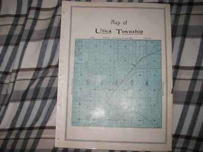
$3.75 Shipping Location: Winter Springs, United States Click Here. Double your traffic. Get Vendio Gallery- Now FREE! Vintage antique 1909 color lithographed map. The map is titled Map of Utica Township. This ... moreis an antique map and not a reprint or reproduction. The map shows the named home and land owners. Named rivers, named railroads, locations of buildings, ad much more of this period, the detail is fascianting. The map is printed on fine paper, on reverse are photographs of Washington Dc. The map is from the very rare 1909 Daily Northwestern Atlas of Winnebago County WI. The map is a fascinating and historic period look at this area at this time. The map shows the home and land owners, the business and industry, the few roads, railroads etc that existed at that time, a fascinating look at these areas in 1909. The photos wont show ther true beauty or detail of these amazing maps. The size of the map is 11.5" by 15.5" Winning bidder pays $3.75 shipping domestic, more foreign. Payment I accept the following forms of payment: PayPal Click to View Image Album Shipping& Handling US Shipping. $3.75 USPS First-Class Mail® International Shipping. $11.50 USPS First-Class Mail International FREE scheduling. Supersized images and templates. Get Vendio Sales Manager. FREE scheduling. Supersized images and templates. Get Vendio Sales Manager.
Buy It Now
$6.80 Shipping Location: Eagle, United States Presented is an authentic, old map taken from a dis-bound atlas published in 1876. Original hand color.
Buy It Now
Free Shipping Location: Denver, United States Even a shooting park is featured west of the river in Oshkosh. for these then relatively young Wisconsin counties and towns. By 1881, Wisconsin had begun ... moreto recover from the crippling economic Panic of 1873 – the worst US depression until 1929 – making the publication of a third state atlas economically viable even following tepid public reception to the previous Walling/Tackabury and Snyder/Van Vechten Wisconsin atlases.

Buy It Now
$10.05 Shipping Location: Belvedere Tiburon, United States Template- Misc Ephemera Chapman's Sectional Map of Wisconsin- 1874 RAREST COPY Pioneer Pocket-Sized Item Description: Large. Multi-colored map, attached ... moreto hard cover, Hard cover. 3 ½" x 5 ½" By: Silas Chapman Map Publisher Miwaukee. Wis. Map Features: Approximate unfolded dimensions: 29" x 34" Stated Scale: 10 miles = 1 Inch Engraved and Printed by: J. Knauber& Company Lithographic Printers Milwaukee. WI Stated Date: 1874 Also shown: Entered according to an act of Congress in the year 1873 by S. Chapman with the Librarian of Congress at Washington" RARE: Bookfinder has editions from 1855. 1856, 1879- these are priced up to $2,500 I could not find an 1874 edition listed anywhere for sale Full Disclosure: Let's be clear- this is a fold up map which is now over 135 years old; and I am NOT an expert on vintage maps. I have provided as many photos as possible to show the condition of this item. Please review them. The"east" side of the map has many"crumpled" and creased areas. There is a piece missing- to the east of Door County- please see photo. There are several small water/moisture stains. Which originate on the back of the map. As with all old. Folded items, the folds will have short tears along them; this map has many of these- most of them short(less than 1" A set of numbers written in an unprinted area- somebody doing addition. Written in pencil. And could be carefully erased. 7 SMBOX, Powered by The free listing tool. List your items fast and easy and manage your active items. 1f3eb5.RcmdId ViewItemDescV4,RlogId p4%60bo7%60jtb9%3Fuk.rp73%28%3E1f3eb5-13ff7f15afa-0xff-
Buy It Now
$6.80 Shipping Location: Eagle, United States Presented is an authentic, old map taken from a dis-bound atlas published in 1876. Original hand color.
Buy It Now
$6.80 Shipping Location: Eagle, United States Wisconsin, Map 1881, Winnebago County. Presented is an authentic old map taken from a dis-bound atlas published in 1881. Hand colored and beautifully ... moreengraved. Reverses to show the community of Sheboygan.
Buy It Now
$8.50 Shipping Location: Croatia City, seat (1844) of Fond du Lac county, east-central Wisconsin, U.S. It lies on the Fond du Lac River, at the southern end of Lake Winnebago, about 55 ... moremiles (90 km) northwest of Milwaukee. Ho-Chunk Nation (Winnebago) Indians were early inhabitants of the area.
Buy It Now
$6.00 Shipping Location: Santa Barbara, United States 1885 Antique Map of Dakota from Page's Atlas This is a double page atlas map showing the counties of Dakota. This is a double page atlas map showing the ... morecounties of Dakota. Compiled from Late and Authentic Sources, Together with Other Valuable Information.
Buy It Now
$6.80 Shipping Location: Eagle, United States Presented is an authentic, old map taken from a dis-bound plat book published in 1916. Age toned, occasional spots, and soiling.
Buy It Now
Free Shipping Location: United States Ripon Wisconsin Green Lake Berlin. Ripon, Green Lake, Berlin, Rush Lake, Waukon, Nepouskon. US Geological Survey Topographic Map. 1918 Dated 1950 Reprinted. ... moreYour family farm, place. This lets us know that your item.
|
|
|
In
|
VINTAGE 1951 WINNEBAGO COUNTY WISCONSIN FARM PLAT BOOK WINNEBAGO CTY FARM BUREAU
VINTAGE 1951 WINNEBAGO COUNTY WISCONSIN FARM PLAT BOOK WINNEBAGO CTY FARM BUREAU, Click to View Image Album Click to View Image Album THIS OFFERING IS FOR A VINTAGE 1951 FARM PLAT BOOK AND BUSINESS GUIDE FOR WINNEBAGO COUNTY WISCONSIN- SPONSORED BY THE WINNEBAGO COUNTY FARM BUREAU. THIS IS A 44 PAGE SOFT COVER BOOKLET PUBLISHED BY ROCKFORD MAPS OF ROCKFORD. ILLINOIS. THIS IS A PRE-OWNED BOOKLET THAT COMES TO YOU IN NICE CONDITION FOR ITS AGE- HOWEVER THE PAGES HAVE YELLOWED SOME(NOT NEARLY AS YELLOW AS THE PICTURE) AND IT HAS A SMALL KNICK OUT OF THE BACK COVER AT THE BOTTOM LEFT HAND CORNER. THE BINDING DOES SHOW SOME WEAR- THE STAPLES ARE NICE AND TIGHT. THE BOOKLET IS FULL OF MAPS AND LOTS OF VINTAGE ADVERTISING. THE COMPLETE OUTSIDE BACK COVER IS DEVOTED TO THE WINNEBAGO COUNTY FARM BUREAU. PLEASE NO INTERNATIONAL BIDDERS! BUYER TO PAY ... moreSHIPPING COSTS. MUST RECEIVE PAYMENT DUE WITHIN 3 DAYS AFTER AUCTIONS END. THANKS FOR LOOKING AND GOOD LUCK BIDDING! Payment PLEASE ONLY BID IF YOU ARE A SERIOUS BIDDER! I WILL SEND AN INVOICE TO THE WINNING BIDDER AT AUCTIONS END WITH SHIPPING INSTRUCTIONS. THANKS! I accept the following forms of payment: PayPal Shipping& Handling I WILL EMAIL THE WINNING BIDDER AT AUCTIONS END WITH SHIPPING INSTRUCTIONS. THANKS! $2.92 USPS First-Class Mail® FREE scheduling. Supersized images and templates. Get Vendio Sales Manager. FREE scheduling. Supersized images and templates. Get Vendio Sales Manager. Over 100.000,000 served. Get FREE counters from Vendio today!
|
|
|
Winnebago County Wisconsin WI Plat Book and Atlas-1969
WINNEBAGO County Wisconsin Triennial Atlas& Plat Book 1969 Comb bound. 46 page plat book includes townships of: Algoma. Blackwolf, Clayton, Menasha, Neenah, Nekimi, Nepeuskun, Omro, Oshkosh, Poygan, Rushford, Utica, Vinland, Winchester, Winneconne and Wolf River. There is a business directory. County index, facts about land descriptions, general highway map, index to owners and the county government directory. There are also interesting ads throughout. Published by Rockford Map Publishers. Inc. The book is in very good condition. It is clean and has a little wear. The top and bottom rings on the binding are missing. THANK YOU FOR LOOKING! This item is posted and managed courtesy of Bonanza.com
|
|
|
1978 / WINNEBAGO COUNTY, WISCONSIN / ATLAS & PLAT BOOK
This item is the 1978 ATLAS& PLAT BOOK for WINNEBAGO COUNTY. WISCONSIN. The atlas/plat book is 50 pages. Including the covers and is completely intact. The issue shows slight fading, slight writing and some binder fraying. The overall condition of this atlas/plat book is very good. I will combine shipping.
|
|
|
1916 Columbia County Wisconsin Platbook Town of Fort Winnebago, Lewiston/Newport
Up for auction are two pages from a 1916 Columbia County Platbook of Fort Winnebago(shown) and Lewiston/Newport on the back. Pages are in very good shape. Corners not bent, really nice colors. Each of the two pages measure 15" x 18 1/2" Will ship flat. Easily framed, fun reading the early settler names!
|
|
|
ANTIQUE 1909 CLAYTON TOWNSHIP WINNEBAGO COUNTY WISCONSIN MAP W LAND OWNERS NR
Click Here. Double your traffic. Get Vendio Gallery- Now FREE! Vintage antique 1909 color lithographed map. The map is titled Map of Clayton Township. This is an antique map and not a reprint or reproduction. The map shows the named home and land owners. Named rivers, named railroads, locations of buildings, ad much more of this period, the detail is fascianting. The map is printed on fine paper, no printing on reverse. The map is from the very rare 1909 Daily Northwestern Atlas of Winnebago County WI. The map is a fascinating and historic period look at this area at this time. The map shows the home and land owners, the business and industry, the few roads, railroads etc that existed at that time, a fascinating look at these areas in 1909. The photos wont show ther true beauty or detail of these amazing maps. The size of the map is 11.5" ... moreby 15.5" Winning bidder pays $3.75 shipping domestic, more foreign. Payment I accept the following forms of payment: PayPal Click to View Image Album Shipping& Handling US Shipping. $3.75 USPS First-Class Mail® International Shipping. $11.50 USPS First-Class Mail International FREE scheduling. Supersized images and templates. Get Vendio Sales Manager. FREE scheduling. Supersized images and templates. Get Vendio Sales Manager.
|
|
 |