-
Christian Collectibles
-
Christian Sheet Music
-
Vatican Stamps
-
Vatican Coins & Paper Money
-
Antiques
-
Antiquities
-
Architectural & Garden
-
Decorative Arts
-
Ethnographic
-
Furniture
-
Maps, Atlases & Globes
-
United States (Pre-1900)
-
United States (1900-Now)
-
AK, HI
-
AL, FL, GA, MS, NC, SC
-
AR, IA, KS, LA, MO, NE
-
AZ, CA, CO, NM, NV, UT
-
CT, MA, ME, NH, RI, VT
-
DC, DE, MD, NJ, NY, PA
-
ID, OR, WA
-
IL, IN, MI, OH, WI
-
MN, MT, ND, SD, WY
-
OK, TX
-
VA, WV, KY, TN
-
Entire US
-
United States (Date Unknown)
-
Africa
-
Asia
-
Australasia/ Oceania
-
Canada
-
Central America/ Caribbean
-
Europe
-
India
-
Ireland
-
Mexico
-
Middle East
-
North America
-
South America
-
United Kingdom
-
Maps on CD
-
World Maps
-
Globes
-
Mixed Lots
-
Reproductions
-
Price Guides & Publications
-
Other
|
In
Order by: Available to: This site contains affiliate links for which I may be compensated
|
Buy It Now
$6.95 Shipping Location: Dover, United States Issued c. 1846, Paris by Thierry. Mid 19th century engraved map with original outline hand color.
Buy It Now
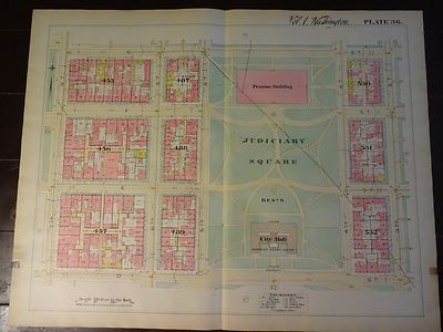
$7.00 Shipping Location: Rockville, United States Up for sale is a great. Large, antique map of a small set of blocks in N.W. DC. This map has property specific detail of the area between D Street and ... moreG Street and stretches from the 7th Street to 3rd Street. This is known as the Judiciary Square area of Northwest. The Judiciary Square Metro Station now sits on 4th Street between Area 531 and Area 532. The National Building Museum now sits where this map shows the Pension Building above Judiciary Square. The Verizon Center sits at 601 F Street and now takes up the entire block of Area 455. Interstate 395 now runs just to the east of 3rd Street and Area 532. The District of Columbia Court of Appeals is in the City Hall spot on this map. This map measures approximately 28 1/2 x 22 1/2 inches. Including the border area. Property specific detail. Map is in color. VERY RARE. This map is from the Real Estate Plat-Book of Washington. District of Columbia. Vol. 1. Comprising the entire North-West Section from the Original Plats of Squares& Subdivisions and Additions upon record in the office of the Surveyor of the City of Washington" Constructed under the direction of and published in 1892 by Griffith M. Hopkins, in Philadelphia, Pennsylvania. Maps this early and showing this much detail of Washington D.C. are VERY SCARCE. The map has fantastic coloring to it. Lots of color coding to represent various attributes(white/stone building. Pink/brick building, yellow/frame building, if it looks like an envelope/a stable or shed, and black& white dotted/green house etc. Map in generally good condition(not perfect but pretty nice condition) Some browning and small chips or creases at edges. Map is blank on the reverse side. There is a crease up the middle where it was originally bound. The map has some small tears and chips around the edges. A brown square stain can be found in the bottom of the right edge and the bottom of the left edge of the map. Caused by the original binding. There are some black scuff marks along the left edge. There are a few pencil marks le
Buy It Now
$20.23 Shipping Location: Medlow Bath, Australia This very uncommon map was published by Alexander Hogg in 1784. As it is a fairly rare item (Mostother similar examples found are coloured reproductions) ... moreit is worthy of inclusion in any definitive map collection.
Buy It Now
$8.60 Shipping Location: Waterloo, United States LOT OF 4 1940 ALLAMAKEE COUNTY IOWA SOIL MAPS- COMPLETE NE NW SE SW NEVER OPENED. Nice condition These are not brittle and appear to be tear free. I didn't ... moreopen them. Large Size You Receive All 4 US Dept of Agriculture
Buy It Now
Free Shipping Location: Anaheim, United States Typically that map at hand, the one being looked at, is in the center box. Covers about 1,568 to 2,240 square miles depending up the longitude & latitude ... morelocation. feature within the bounds of the map, which frequently is a community, town, or city.
Buy It Now
Free Shipping Location: Anaheim, United States BLM Edition Sisseton 1982 - USGS Milbank NW/4 1979. Typically that map at hand, the one being looked at, is in the center box. South Dakota - North Dakota. ... moreCovers about 1,568 to 2,240 square miles depending up the longitude & latitude location.
Buy It Now
Free Shipping Location: Anaheim, United States Typically that map at hand, the one being looked at, is in the center box. Covers about 1,568 to 2,240 square miles depending up the longitude & latitude ... morelocation. One Printed Map Sheet that is production folded.
Buy It Now
Free Shipping Location: Anaheim, United States Typically that map at hand, the one being looked at, is in the center box. Covers about 1,568 to 2,240 square miles depending up the longitude & latitude ... morelocation. feature within the bounds of the map, which frequently is a community, town, or city.

Buy It Now
Free Shipping Location: Anaheim, United States CONDITION: LIKE NEW Map Publisher: U.S. Department of the Interior BUREAU OF LAND MANAGEMENT edition from US Geological Survey Base Map in cooperation ... morewith California State Parks and US Department of Agriculture Forest Service 1:100.000 scale Map is folded. Pictures are of the front and back as folded. When folded the map measures approximately 9 inches by 4 inches. Wiatava Lodge#13 of Orange County Council#39. Boy Scouts of America International Buyers Please Note: Customs/ Import duties. Taxes, and charges are not included in the item price or shipping charges. These charges are the buyers responsibility. Please check with your country's customs office to determine what these additional costs will be prior to bidding/buying. In some situations some items are not allowed to be sent to your country because of the buyers import laws. Buyers please check that an item is allowed to be sent to your country. These charges are normally collected by the shipping delivering freight company or when you pick the item up. Do not confuse them for additional shipping charges from me. The amount reported to Customs for merchandise value is the amount of the items plus the amount of shipping. We do not mark merchandise values below value or mark items as" gift" US and International government regulations prohibit such behavior. ID: map1481 Powered by,RcmdId ViewItemDescV4,RlogId p4%60bo7%60jtb9%3Fuk%600d72f%2B%3F0%3C%3E-14777571a2b-0x10b-

Buy It Now
Free Shipping Location: Anaheim, United States CONDITION: LIKE NEW Map Publisher: U.S. Department of the Interior BUREAU OF LAND MANAGEMENT edition from US Geological Survey Base Map in cooperation ... morewith California State Parks and US Department of Agriculture Forest Service 1:100.000 scale Map is folded. Pictures are of the front and back as folded. When folded the map measures approximately 9 inches by 4 inches. Wiatava Lodge#13 of Orange County Council#39. Boy Scouts of America International Buyers Please Note: Customs/ Import duties. Taxes, and charges are not included in the item price or shipping charges. These charges are the buyers responsibility. Please check with your country's customs office to determine what these additional costs will be prior to bidding/buying. In some situations some items are not allowed to be sent to your country because of the buyers import laws. Buyers please check that an item is allowed to be sent to your country. These charges are normally collected by the shipping delivering freight company or when you pick the item up. Do not confuse them for additional shipping charges from me. The amount reported to Customs for merchandise value is the amount of the items plus the amount of shipping. We do not mark merchandise values below value or mark items as" gift" US and International government regulations prohibit such behavior. ID: map1410 Powered by

Buy It Now
Free Shipping Location: Anaheim, United States CONDITION: LIKE NEW Map Publisher: U.S. Department of the Interior BUREAU OF LAND MANAGEMENT edition from US Geological Survey Base Map in cooperation ... morewith California State Parks and US Department of Agriculture Forest Service 1:100.000 scale Map is folded. Pictures are of the front and back as folded. When folded the map measures approximately 9 inches by 4 inches. Wiatava Lodge#13 of Orange County Council#39. Boy Scouts of America International Buyers Please Note: Customs/ Import duties. Taxes, and charges are not included in the item price or shipping charges. These charges are the buyers responsibility. Please check with your country's customs office to determine what these additional costs will be prior to bidding/buying. In some situations some items are not allowed to be sent to your country because of the buyers import laws. Buyers please check that an item is allowed to be sent to your country. These charges are normally collected by the shipping delivering freight company or when you pick the item up. Do not confuse them for additional shipping charges from me. The amount reported to Customs for merchandise value is the amount of the items plus the amount of shipping. We do not mark merchandise values below value or mark items as" gift" US and International government regulations prohibit such behavior. ID: map1577 Powered by

Buy It Now
Free Shipping Location: Anaheim, United States CONDITION: LIKE NEW Map Publisher: U.S. Department of the Interior BUREAU OF LAND MANAGEMENT edition from US Geological Survey Base Map in cooperation ... morewith California State Parks and US Department of Agriculture Forest Service 1:100.000 scale Map is folded. Pictures are of the front and back as folded. When folded the map measures approximately 9 inches by 4 inches. Wiatava Lodge#13 of Orange County Council#39. Boy Scouts of America International Buyers Please Note: Customs/ Import duties. Taxes, and charges are not included in the item price or shipping charges. These charges are the buyers responsibility. Please check with your country's customs office to determine what these additional costs will be prior to bidding/buying. In some situations some items are not allowed to be sent to your country because of the buyers import laws. Buyers please check that an item is allowed to be sent to your country. These charges are normally collected by the shipping delivering freight company or when you pick the item up. Do not confuse them for additional shipping charges from me. The amount reported to Customs for merchandise value is the amount of the items plus the amount of shipping. We do not mark merchandise values below value or mark items as" gift" US and International government regulations prohibit such behavior. ID: map1439 Powered by
Buy It Now
Free Shipping Location: Anaheim, United States Typically that map at hand, the one being looked at, is in the center box. Covers about 1,568 to 2,240 square miles depending up the longitude & latitude ... morelocation. One Printed Map Sheet that is production folded.
Buy It Now
$6.95 Shipping Location: Dover, United States Issued c. 1790's, London. Longitude given from London.
Buy It Now
$6.95 Shipping Location: Dover, United States India - The North West Provinces and the Oude. Engraved by Weller. Soft old original crease across the map which only shows up in certain light angles ... more(we picture it so as to emphasize).

Buy It Now
Free Shipping Location: Kaaawa, United States A Vintage Planiglobii Terrestris Mappa Monde by J.M.Haas Homann's Heirs published Nuremberg 1746. The bottom right hand corner reads"Leisure ... moreArts Ltd" Printed in England. Sorry don't know anymore( hence the.99p start)except it appears to be on very thick almost card like paper and is old. The actual map size is approx 640mm long x 550mm.It is in very good condition considering it's age, although for accuracy, there is some minor discolouration and foxing mainly around the edges and a small tear down right side which has been stabilised on the reverse with brown tapeThis will be Tubed for shipment PL EASE READ AND CHECK THE PHOTO'S CAREFULLY AND UNDERSTAND WHAT YOU ARE BIDDING FOR AS. RETURNS ARE ONLY ACCEPTED, IN THE UNLIKELY EVENT, THIS ITEM HAS BEEN INCORRECTLY DESCRIBED THE MAJORITY OF MY ITEMS ARE OVER 100 YEARS OLD AND AS SUCH DO SHOW SIGNS OF AGE. BUT, I AIM TO DESCRIBE ANY FORM OF DAMAGE OR MARKS THAT ARE NOT CONDUCIVE WITH IT'S AGE. IF YOU ARE EXPECTING NEAR OR PERFECT ITEMS PLEASE REFRAIN FROM BIDDING BUT, IN THE UNLIKELY EVENT THERE IS A PROBLEM. WITH THIS LISTING PLEASE CONTACT ME FIRST SO IT CAN BE SORTED OUT WITHOUT THE INVOLVEMENT OF EBAY PLEASE PAY WITHIN 2 DAYS OF AUCTION END Powered by

Buy It Now
Free Shipping Location: Anaheim, United States CONDITION: LIKE NEW Map Publisher: U.S. Department of the Interior BUREAU OF LAND MANAGEMENT edition from US Geological Survey Base Map in cooperation ... morewith California State Parks and US Department of Agriculture Forest Service 1:100.000 scale Map is folded. Pictures are of the front and back as folded. When folded the map measures approximately 9 inches by 4 inches. Wiatava Lodge#13 of Orange County Council#39. Boy Scouts of America International Buyers Please Note: Customs/ Import duties. Taxes, and charges are not included in the item price or shipping charges. These charges are the buyers responsibility. Please check with your country's customs office to determine what these additional costs will be prior to bidding/buying. In some situations some items are not allowed to be sent to your country because of the buyers import laws. Buyers please check that an item is allowed to be sent to your country. These charges are normally collected by the shipping delivering freight company or when you pick the item up. Do not confuse them for additional shipping charges from me. The amount reported to Customs for merchandise value is the amount of the items plus the amount of shipping. We do not mark merchandise values below value or mark items as" gift" US and International government regulations prohibit such behavior. ID: map1783 Powered by

Buy It Now
Free Shipping Location: Anaheim, United States CONDITION: LIKE NEW Map Publisher: U.S. Department of the Interior BUREAU OF LAND MANAGEMENT edition from US Geological Survey Base Map in cooperation ... morewith California State Parks and US Department of Agriculture Forest Service 1:100.000 scale Map is folded. Pictures are of the front and back as folded. When folded the map measures approximately 9 inches by 4 inches. Wiatava Lodge#13 of Orange County Council#39. Boy Scouts of America International Buyers Please Note: Customs/ Import duties. Taxes, and charges are not included in the item price or shipping charges. These charges are the buyers responsibility. Please check with your country's customs office to determine what these additional costs will be prior to bidding/buying. In some situations some items are not allowed to be sent to your country because of the buyers import laws. Buyers please check that an item is allowed to be sent to your country. These charges are normally collected by the shipping delivering freight company or when you pick the item up. Do not confuse them for additional shipping charges from me. The amount reported to Customs for merchandise value is the amount of the items plus the amount of shipping. We do not mark merchandise values below value or mark items as" gift" US and International government regulations prohibit such behavior. ID: map0984 Powered by
Buy It Now
Free Shipping Location: Anaheim, United States 1981-1979 - Tularosa NW/4. Typically that map at hand, the one being looked at, is in the center box. Covers about 1,568 to 2,240 square miles depending ... moreup the longitude & latitude location. Bio-predation & Oxidation (aging, age discoloration mainly on the outside panels).
Buy It Now
Free Shipping Location: Anaheim, United States Typically that map at hand, the one being looked at, is in the center box. Covers about 1,568 to 2,240 square miles depending up the longitude & latitude ... morelocation. feature within the bounds of the map, which frequently is a community, town, or city.
Buy It Now
Free Shipping Location: Anaheim, United States Typically that map at hand, the one being looked at, is in the center box. 1:100,00-scale topographic map showing Covers about 1,568 to 2,240 square miles ... moredepending up the longitude & latitude location.

Buy It Now
Free Shipping Location: Anaheim, United States CONDITION: LIKE NEW- age discoloration Map Publisher: U.S. Department of the Interior BUREAU OF LAND MANAGEMENT edition from US Geological Survey Base ... moreMap in cooperation with California State Parks and US Department of Agriculture Forest Service 1:100.000 scale Map is folded. Pictures are of the front and back as folded. When folded the map measures approximately 9 inches by 4 inches. Wiatava Lodge#13 of Orange County Council#39. Boy Scouts of America International Buyers Please Note: Customs/ Import duties. Taxes, and charges are not included in the item price or shipping charges. These charges are the buyers responsibility. Please check with your country's customs office to determine what these additional costs will be prior to bidding/buying. In some situations some items are not allowed to be sent to your country because of the buyers import laws. Buyers please check that an item is allowed to be sent to your country. These charges are normally collected by the shipping delivering freight company or when you pick the item up. Do not confuse them for additional shipping charges from me. The amount reported to Customs for merchandise value is the amount of the items plus the amount of shipping. We do not mark merchandise values below value or mark items as" gift" US and International government regulations prohibit such behavior. ID: map1468 Powered by
Buy It Now
$4.50 Shipping Location: United States A very detailed large map showing area in Germany, with the town of Nubau in upper left, and the small town of Thurmansbang in the lower right.
Buy It Now
Free Shipping Location: Anaheim, United States Typically that map at hand, the one being looked at, is in the center box. 1:100,00-scale topographic map showing Covers about 1,568 to 2,240 square miles ... moredepending up the longitude & latitude location.
Buy It Now
Free Shipping Location: Anaheim, United States Santa Fe BLM Edition 1986 - USGS Santa Fe NW/4 1983. Typically that map at hand, the one being looked at, is in the center box. 1:100,00-scale topographic ... moremap showing Covers about 1,568 to 2,240 square miles depending up the longitude & latitude location.

Buy It Now
Free Shipping Location: Anaheim, United States CONDITION: LIKE NEW Map Publisher: U.S. Department of the Interior BUREAU OF LAND MANAGEMENT edition from US Geological Survey Base Map in cooperation ... morewith California State Parks and US Department of Agriculture Forest Service 1:100.000 scale Map is folded. Pictures are of the front and back as folded. When folded the map measures approximately 9 inches by 4 inches. Wiatava Lodge#13 of Orange County Council#39. Boy Scouts of America International Buyers Please Note: Customs/ Import duties. Taxes, and charges are not included in the item price or shipping charges. These charges are the buyers responsibility. Please check with your country's customs office to determine what these additional costs will be prior to bidding/buying. In some situations some items are not allowed to be sent to your country because of the buyers import laws. Buyers please check that an item is allowed to be sent to your country. These charges are normally collected by the shipping delivering freight company or when you pick the item up. Do not confuse them for additional shipping charges from me. The amount reported to Customs for merchandise value is the amount of the items plus the amount of shipping. We do not mark merchandise values below value or mark items as" gift" US and International government regulations prohibit such behavior. ID: map0994 Powered by
Buy It Now
Free Shipping Location: Anaheim, United States Typically that map at hand, the one being looked at, is in the center box. Covers about 1,568 to 2,240 square miles depending up the longitude & latitude ... morelocation. feature within the bounds of the map, which frequently is a community, town, or city.

Buy It Now
Free Shipping Location: Anaheim, United States CONDITION: bent/curled edges& corners Map Publisher: U.S. Department of the Interior BUREAU OF LAND MANAGEMENT edition from US Geological Survey Base ... moreMap in cooperation with California State Parks and US Department of Agriculture Forest Service 1:100.000 scale Map is folded. Pictures are of the front and back as folded. When folded the map measures approximately 9 inches by 4 inches. Wiatava Lodge#13 of Orange County Council#39. Boy Scouts of America International Buyers Please Note: Customs/ Import duties. Taxes, and charges are not included in the item price or shipping charges. These charges are the buyers responsibility. Please check with your country's customs office to determine what these additional costs will be prior to bidding/buying. In some situations some items are not allowed to be sent to your country because of the buyers import laws. Buyers please check that an item is allowed to be sent to your country. These charges are normally collected by the shipping delivering freight company or when you pick the item up. Do not confuse them for additional shipping charges from me. The amount reported to Customs for merchandise value is the amount of the items plus the amount of shipping. We do not mark merchandise values below value or mark items as" gift" US and International government regulations prohibit such behavior. ID: map1802 Powered by
Buy It Now
$6.95 Shipping Location: Dover, United States Issued 1895, Philadelphia by Bradley. N.W. Africa - South Africa - Egypt, Arabia, Petra, and Lower Nubia. Original center fold as issued. Late 19th century ... morelarge hand colored folio sheet map.
Buy It Now
$14.99 Shipping Location: Ivanhoe, Australia The SDUK was published in its entirety or in part by many publishers including Baldwin and Cradock 1829-32, Chapman & Hall in 1844, Charles Knight & co. ... more1846 – 1852. G. Cox published the SDUK between 1852-3, Stanford 1857-70 and later revised edition were also published after Stanford.
Buy It Now
$14.99 Shipping Location: Ivanhoe, Australia Moreover, 'their frequent use of eighteenth century sources, often from the 1740s, provided their atlas with up-to-date information. De Vaugondy, Gilles ... moreRobert 1688 - 1766. Date: - 1772. The smaller map also shows the Straits of Anian, but depicts an open sea above, clearly portending a NW Passage in the Arctic Circle.
Buy It Now
$14.99 Shipping Location: Ivanhoe, Australia In the Pre-Independence era it was also known as Eastern Gibraltar. This is because the fort was almost unconquerable. Kanhoji fought against the British, ... moreDutch and Portuguese naval interests on the coasts of India during the 18th century.
Buy It Now
$4.88 Shipping Location: Las Cruces, United States Publisher: U.S. Geological Survey. Map: MF-113.

Buy It Now
Free Shipping Location: Anaheim, United States CONDITION: bent/curled edges& corners Map Publisher: U.S. Department of the Interior BUREAU OF LAND MANAGEMENT edition from US Geological Survey Base ... moreMap in cooperation with California State Parks and US Department of Agriculture Forest Service 1:100.000 scale Map is folded. Pictures are of the front and back as folded. When folded the map measures approximately 9 inches by 4 inches. Wiatava Lodge#13 of Orange County Council#39. Boy Scouts of America International Buyers Please Note: Customs/ Import duties. Taxes, and charges are not included in the item price or shipping charges. These charges are the buyers responsibility. Please check with your country's customs office to determine what these additional costs will be prior to bidding/buying. In some situations some items are not allowed to be sent to your country because of the buyers import laws. Buyers please check that an item is allowed to be sent to your country. These charges are normally collected by the shipping delivering freight company or when you pick the item up. Do not confuse them for additional shipping charges from me. The amount reported to Customs for merchandise value is the amount of the items plus the amount of shipping. We do not mark merchandise values below value or mark items as" gift" US and International government regulations prohibit such behavior. ID: map1805 Powered by
Buy It Now
$42.71 Shipping Location: New York, United States (A LATER, SECOND EDITION WAS ALSO PUBLISHED BY G. NICOL AND T. CADELL). Condition: EXCELLENT CONDITION. Or Local Pickup in Manhattan, Greenwich Village ... moreneighborhood, Zip code 10011.

Buy It Now
$9.97 Shipping Condition: Unspecified Location: LONDON, United Kingdom Staples Corner Business Park/M1-A406 Interchange/Brent cross shopping Centre/Dollis hill Colour satellite composite photograph; Scale 1:6.000, 2000 Title ... moreof map: Staples Corner Business Park/M1-A406 Interchange/Brent cross shopping Centre/Dollis hill' The image below shows an enlarged cross section from the centre of the map to show the level of printed detail: DATE PRINTED: 2000 IMAGE SIZE: Approx 35.5 x 26.0cm. 14 x 10.25 inches(Large) ARTIST/CARTOGRAPHER/ENGRAVER: Photography by Getmapping.com PROVENANCE: London the Photographic Atlas" Please note that virtually all antique and vintage maps and prints have been extracted from books. Atlases or newspapers. TYPE: Colour satellite composite photograph; Scale 1:6.000 VERSO: There is another similar image printed on the reverse. The printing on the back does not show through to the front CONDITION: Good; suitable for framing. However. Please note: The map has been printed up to the edges of the paper, as issued, hence there are no margins or borders. Please check the scan for any blemishes prior to making your purchase. Virtually all antiquarian maps and prints are subject to some normal aging due to use and time which is not obtrusive unless otherwise stated. I offer a no questions asked return policy- see below. AUTHENTICITY: This is an authentic historic print. Published at the date stated above. I do not offer reproductions. It is not a modern copy. The term'original' when applied to a print means that it was printed at the first or original date of publication; it does not imply that the item is unique. Print' means any image created by applying an inked block to paper or card under pressure by any method including wood engraving, steel engraving, copperplate, wood cut and lithography. REMARKS: FRANCE: Gravures et Cartes anciennes. DEUTSCHLAND: Alte Lankarten und Stadt ansichten. ITALIA: Stampe& Mappe antiche. ESPAÑA: Mapas antiquos y impresiones antiguas. E and OE. Force Majeure. English law shall apply. RETURNS POLICY: I offer a
Buy It Now
$4.95 Shipping Location: Willow Grove, United States This is an ORIGINAL Northwest Georgia map titled Georgia - Northwestern Part which was taken from a 1937 atlas. There is a Georgia map image and text ... moreon the reverse side of this map page.
Buy It Now
$9.97 Shipping Condition: Unspecified Location: LONDON, United Kingdom Title of map:'Mill hill/Copthall Stadium/Holders Hill/Church End/Hendon/M1'. 'Mill hill/Copthall Stadium/Holders Hill/Church End/Hendon/M1'. The image ... morebelow shows an enlarged cross section from the centre of the map to show the level of printed detail.
Buy It Now
$14.99 Shipping Location: Ivanhoe, Australia The SDUK was published in its entirety or in part by many publishers including Baldwin and Cradock 1829-32, Chapman & Hall in 1844, Charles Knight & co. ... more1846 – 1852. G. Cox published the SDUK between 1852-3, Stanford 1857-70 and later revised edition were also published after Stanford.
Buy It Now
$14.99 Shipping Location: Ivanhoe, Australia Ref#: - 20642, 20641, 20584, 20583, 32559. The SDUK was published in its entirety or in part by many publishers including Baldwin and Cradock 1829-32, ... moreChapman & Hall in 1844, Charles Knight & co. 1846 – 1852.
Buy It Now
$9.97 Shipping Condition: Unspecified Location: LONDON, United Kingdom PROVENANCE: "Geographers' Atlas of Greater London"; published by Geographers' map co., Ltd, London. 2nd edition. DATE PRINTED: 1956. CONDITION: Good; ... moresuitable for framing. The map you will receive is in good condition but there may be minor variations in the condition from that shown in the image.
Buy It Now
$9.97 Shipping Condition: Unspecified Location: LONDON, United Kingdom PROVENANCE: "Geographers' Atlas of Greater London"; published by Geographers' map co., Ltd, London. 1st edition. DATE PRINTED: 1948. CONDITION: Good; ... moresuitable for framing. The map you will receive is in good condition but there may be minor variations in the condition from that shown in the image.
Buy It Now
$17.95 Shipping Location: Cambridge, United States Approx 27 x 22". Each has its own specific set of flaws and wear. Opposite side may or may not have prints or text which may or may not be related to ... moreone shown. Your opinion may differ. In great antique condition with typical used wear. mostly on edges.
Buy It Now
$4.99 Shipping Location: Fairview, United States An Original Antique Map: Not a Reproduction! Condition: The map is in Good condition, blank on reverse, with a centerfold as issued, original hand coloring, ... moreprinted on a strong flexible page. The pics are of the actual map.
Buy It Now
$6.75 Shipping Location: Oconomowoc, United States Incredibly detailed view.Includes all of Venezuela, Colombia and Ecuador.
Buy It Now
$6.75 Shipping Location: Oconomowoc, United States "West Canada".Stielers Hand Atlas, Gotha, Justus Perthes, Germany, 1913 Edition. A beautiful view of Northwestern Canada.Includes Manitoba, Saskatchewan ... moreAlberta, British Columbia, Yukon, and almost all of the Northwest Territories.
Buy It Now
$9.75 Shipping Location: Boonville, United States This map has been in storage and has been rolled up and untouched up for many years. Columbus, Indiana. State Of Indiana. Indianapolis, Indiana. NW/4 ... moreUniontown 15' Quadrangle.
Buy It Now
$7.56 Shipping Location: Canada
Buy It Now
$4.13 Shipping Location: Livermore, United States Mapping organization: USGS. Topographic Map Title: Fallout Hills, NV Quadrangle. Landmarks: Desert National Wildlife Range, Chert Ridge, Fallout Hills. ... moreknown as Nevada National Security Site (NNSS) and/or sections of Nellis Air Force Base.
Buy It Now
$129.00 Shipping Location: Tracy, United States 15th, 16th, 17th, & 18th of June 1859. Mining Claims of Port Wine in. The Port Wine district is in northwestern Sierra County about 10 miles NW of Downieville. ... moreThe La Porte district adjoins on the NW, the Poverty Hill district on the SW, and the Poker Flat-Howland Flat district on the NE.
Buy It Now
$30.25 Shipping Location: Billings, United States Vintage/Old SEACRAFT Framed Map & serving tray.Made in Waymouth, Mass.Features brass cleat handles.Framed with wood & glass and bordered with braided ... morerope.Map of U.S. NW Territory of San Juan Islands and Haro Strait to name a few. Ready to hang on your wall or use as a serving tray.Missing a nob on backside (1 of 4).Has a water/coffee stain on right 1/3 of map. Glass moves when moved side to side.Please see photos for the best description before purchasing.Measures: 23.5” Wide X 15.5” Tall X 7/8” ThickWeighs: 6 Pounds - 5 Ounces
Buy It Now
Free Shipping Location: Schenectady, United States 7.5 Minute Series, Glenfield, NY, NW/4 Port Leyden 15' Quadrangle, 1966
Buy It Now
$4.99 Shipping Location: Fairview, United States Condition: It is in Good condition with a couple of minor smudges around the margins and a bend on the tip of the bottom left corner, nothing very distracting, ... moreas seen in the pic. Otherwise, the page is strong with no tears and the color is still very bright.
Buy It Now
$4.99 Shipping Location: Fairview, United States Stieler's Hand Atlas, published in Gotha by Justus Perthes. The publisher is stated in the bottom center, the title of the atlas is in the upper right ... morecorner and the printing details in the bottom left margin.
Buy It Now
$7.75 Shipping Location: Boonville, United States Nw/4 Haubstadt 15' Quadrangle. Cynthiana, Indiana. This map has been in storage and has been rolled up and untouched up for many years. State Of Indiana. ... moreIndianapolis, Indiana.
Buy It Now
$22.43 Shipping Location: HASTINGS, United Kingdom It was engraved by Laurent. The map has no date - it was probably first issued c1758. It is a remarkably detailed map, probably the result of two voyages ... moreby the Danish explorer Vitus Bering in 1728 and 1740.
Buy It Now
$9.75 Shipping Location: Boonville, United States Folsomville, Indiana. This map has been in storage and has been rolled up and untouched up for many years. State Of Indiana. Indianapolis, Indiana. NW/4 ... moreDegonia Springs 15' Quadrangle.
Buy It Now
$18.69 Shipping Location: CHICHESTER, United Kingdom Printed on 4 sheets. (NW, NE, SW, SE), dissected and linen backed. Original colour. VG condition. No slip case. Ref - Howgego DH 333/4. Colour: Coloured. ... moreWidth (cms) x Height (cms): 70.0 x 55.0.
Buy It Now
$14.99 Shipping Location: Ivanhoe, Australia The SDUK was published in its entirety or in part by many publishers including Baldwin and Cradock 1829-32, Chapman & Hall in 1844, Charles Knight & co. ... more1846 – 1852. G. Cox published the SDUK between 1852-3, Stanford 1857-70 and later revised edition were also published after Stanford.
Buy It Now
$14.99 Shipping Location: Ivanhoe, Australia In the Pre-Independence era it was also known as Eastern Gibraltar. This is because the fort was almost unconquerable. Kanhoji fought against the British, ... moreDutch and Portuguese naval interests on the coasts of India during the 18th century.
|
|
|
In
|
USGS BLM edition topographic map SISSETON South Dakota North MILBANK NW/4 1982
CONDITION: bent edges. Biopredation, oxidation, and fading Map Publisher: U.S. Department of the Interior BUREAU OF LAND MANAGEMENT edition from US Geological Survey Base Map in cooperation with California State Parks and US Department of Agriculture Forest Service 1:100.000 scale Map is folded. Pictures are of the front and back as folded. When folded the map measures approximately 9 inches by 4 inches. Wiatava Lodge#13 of Orange County Council#39. Boy Scouts of America International Buyers Please Note: Customs/ Import duties. Taxes, and charges are not included in the item price or shipping charges. These charges are the buyers responsibility. Please check with your country's customs office to determine what these additional costs will be prior to bidding/buying. In some situations some items are not allowed to be sent to your country ... morebecause of the buyers import laws. Buyers please check that an item is allowed to be sent to your country. These charges are normally collected by the shipping delivering freight company or when you pick the item up. Do not confuse them for additional shipping charges from me. The amount reported to Customs for merchandise value is the amount of the items plus the amount of shipping. We do not mark merchandise values below value or mark items as" gift" US and International government regulations prohibit such behavior. ID: map0900 Powered by
|
|
|
USGS BLM edition topographic map North Dakota MOHALL 1981 MINOT NW/4
CONDITION: LIKE NEW- age discoloration Map Publisher: U.S. Department of the Interior BUREAU OF LAND MANAGEMENT edition from US Geological Survey Base Map in cooperation with California State Parks and US Department of Agriculture Forest Service 1:100.000 scale Map is folded. Pictures are of the front and back as folded. When folded the map measures approximately 9 inches by 4 inches. Wiatava Lodge#13 of Orange County Council#39. Boy Scouts of America International Buyers Please Note: Customs/ Import duties. Taxes, and charges are not included in the item price or shipping charges. These charges are the buyers responsibility. Please check with your country's customs office to determine what these additional costs will be prior to bidding/buying. In some situations some items are not allowed to be sent to your country because of the buyers ... moreimport laws. Buyers please check that an item is allowed to be sent to your country. These charges are normally collected by the shipping delivering freight company or when you pick the item up. Do not confuse them for additional shipping charges from me. The amount reported to Customs for merchandise value is the amount of the items plus the amount of shipping. We do not mark merchandise values below value or mark items as" gift" US and International government regulations prohibit such behavior. ID: map1468 Powered by
|
|
|
USGS BLM edition topographic map Montana RICHEY 1983 mineral GLENDIVE NW/4
CONDITION: LIKE NEW Map Publisher: U.S. Department of the Interior BUREAU OF LAND MANAGEMENT edition from US Geological Survey Base Map in cooperation with California State Parks and US Department of Agriculture Forest Service 1:100.000 scale Map is folded. Pictures are of the front and back as folded. When folded the map measures approximately 9 inches by 4 inches. Wiatava Lodge#13 of Orange County Council#39. Boy Scouts of America International Buyers Please Note: Customs/ Import duties. Taxes, and charges are not included in the item price or shipping charges. These charges are the buyers responsibility. Please check with your country's customs office to determine what these additional costs will be prior to bidding/buying. In some situations some items are not allowed to be sent to your country because of the buyers import laws. ... moreBuyers please check that an item is allowed to be sent to your country. These charges are normally collected by the shipping delivering freight company or when you pick the item up. Do not confuse them for additional shipping charges from me. The amount reported to Customs for merchandise value is the amount of the items plus the amount of shipping. We do not mark merchandise values below value or mark items as" gift" US and International government regulations prohibit such behavior. ID: map1577 Powered by
|
|
|
USGS BLM edition planimetric map North Dakota CROSBY 1987 WILLISTON NW/4 surface
CONDITION: bent/curled edges& corners Map Publisher: U.S. Department of the Interior BUREAU OF LAND MANAGEMENT edition from US Geological Survey Base Map in cooperation with California State Parks and US Department of Agriculture Forest Service 1:100.000 scale Map is folded. Pictures are of the front and back as folded. When folded the map measures approximately 9 inches by 4 inches. Wiatava Lodge#13 of Orange County Council#39. Boy Scouts of America International Buyers Please Note: Customs/ Import duties. Taxes, and charges are not included in the item price or shipping charges. These charges are the buyers responsibility. Please check with your country's customs office to determine what these additional costs will be prior to bidding/buying. In some situations some items are not allowed to be sent to your country because of the ... morebuyers import laws. Buyers please check that an item is allowed to be sent to your country. These charges are normally collected by the shipping delivering freight company or when you pick the item up. Do not confuse them for additional shipping charges from me. The amount reported to Customs for merchandise value is the amount of the items plus the amount of shipping. We do not mark merchandise values below value or mark items as" gift" US and International government regulations prohibit such behavior. ID: map1805 Powered by
|
|
 |