-
Christian Collectibles
-
Christian Sheet Music
-
Vatican Stamps
-
Vatican Coins & Paper Money
-
Antiques
-
Antiquities
-
Architectural & Garden
-
Decorative Arts
-
Ethnographic
-
Furniture
-
Maps, Atlases & Globes
-
United States (Pre-1900)
-
United States (1900-Now)
-
AK, HI
-
AL, FL, GA, MS, NC, SC
-
AR, IA, KS, LA, MO, NE
-
AZ, CA, CO, NM, NV, UT
-
CT, MA, ME, NH, RI, VT
-
DC, DE, MD, NJ, NY, PA
-
ID, OR, WA
-
IL, IN, MI, OH, WI
-
MN, MT, ND, SD, WY
-
OK, TX
-
VA, WV, KY, TN
-
Entire US
-
United States (Date Unknown)
-
Africa
-
Asia
-
Australasia/ Oceania
-
Canada
-
Central America/ Caribbean
-
Europe
-
India
-
Ireland
-
Mexico
-
Middle East
-
North America
-
South America
-
United Kingdom
-
Maps on CD
-
World Maps
-
Globes
-
Mixed Lots
-
Reproductions
-
Price Guides & Publications
-
Other
|
In
Order by: Available to: This site contains affiliate links for which I may be compensated
|
Buy It Now
$6.80 Shipping Location: Braham, United States HERE IS A RURAL DIRECTORY. BLUE EARTH COUNTY MINNESOTA.
Buy It Now
$6.80 Shipping Location: Eagle, United States Presented is an authentic old map taken from a dis-bound atlas published in 1929. Original Hand Color.
Buy It Now
Free Shipping Location: Britt, United States Includes the city of Blue Earth.
Buy It Now
$4.87 Shipping Location: Braham, United States HERE IS A PLAT BOOK. BLUE EARTH COUNTY MINNESOTA. GOOD USED CONDITION.
Buy It Now
$6.00 Shipping Location: Columbia, United States
Buy It Now
$4.13 Shipping Location: Columbia, United States Original Soil map dated 1906. Blue Earth County Minnesota. Lake Crystal. Madison Lake. ANTIQUE MAP.
Buy It Now
Free Shipping Location: San Antonio, United States This Map was removed from a 1914 Atlas and is in good acceptable condition. This map is not new or in new condition, it was printed in 1914. pencil marks ... more& brittle paper from over 100+ years of aging.
Buy It Now
$14.50 Shipping Location: Mankato, United States Blue Earth County MN Atlas Plat Book c1995 - Midland Atlas Co. Great condition. Shipped Priority Mail
Buy It Now
$14.50 Shipping Location: Mankato, United States Blue Earth County MN Atlas Plat Book c1980 - Midland Atlas Co. Great condition. Shipped Priority Mail
Buy It Now
$4.13 Shipping Location: Columbia, United States Good Thunder. Blue Earth County, Minnesota. Antique map. Blue Earth. Paper is over 100 years old, use care when unfolding.
Buy It Now
$4.99 Shipping Location: Fairview, United States The Geological Survey of Minnesota: Final Report. Also included is a page of text explaining the geology shown on the map. 1900-1901, published by the ... moreGeological and Natural History Survey of Minnesota.
Buy It Now
$4.00 Shipping Location: Columbus, United States The map shows Mankato, Lake Crystal, Mapleton, Good Thunder, Madison Lake, and more. THIS IS AN ORIGINAL PRINTING - NOT A MODERN REPRODUCTION. HOFFMAN ... moreBOOKS, ABAA, IOBA.
Buy It Now
$6.80 Shipping Location: Eagle, United States Presented is an authentic old map taken from a dis-bound atlas published in 1929. Original Hand Color.
Buy It Now
$14.50 Shipping Location: Mankato, United States Blue Earth County MN Atlas Plat Book c1984 - Midland Atlas Co. Great condition. Shipped Priority Mail
Buy It Now
$6.80 Shipping Location: Eagle, United States Presented is an authentic old map taken from a dis-bound atlas published in 1929. Original Hand Color.
Buy It Now
$6.80 Shipping Location: Eagle, United States Presented is an authentic old map taken from a dis-bound atlas published in 1929. Original Hand Color.
Buy It Now
$6.00 Shipping Location: Columbus, United States This map is in Very Good condition, with nice bright color. The map shows Blue Earth, Winnebago, Wells, Bricelyn, Kiester, Frost, and more. HOFFMAN BOOKS, ... moreABAA, IOBA.
Buy It Now
$6.80 Shipping Location: Eagle, United States Presented is an authentic old map taken from a dis-bound atlas published in 1929. Original Hand Color.
Buy It Now
$6.80 Shipping Location: Eagle, United States Presented is an authentic old map taken from a dis-bound atlas published in 1929. Original Hand Color.
Buy It Now
$6.80 Shipping Location: Eagle, United States Presented is an authentic old map taken from a dis-bound atlas published in 1929. Original Hand Color.
Buy It Now
$6.80 Shipping Location: Eagle, United States Presented is an authentic, old map taken from a dis-bound atlas published in 1874. Original hand color. Don't miss this opportunity to add to your collection.
Buy It Now
$6.80 Shipping Location: Eagle, United States Presented is an authentic old map taken from a dis-bound atlas published in 1929. Original Hand Color.
Buy It Now
$6.80 Shipping Location: Eagle, United States Presented is an authentic old map taken from a dis-bound atlas published in 1929. Original Hand Color.
Buy It Now
$6.80 Shipping Location: Eagle, United States Presented is an authentic old map taken from a dis-bound atlas published in 1929. Original Hand Color.
Buy It Now
Free Shipping Location: Britt, United States
Buy It Now
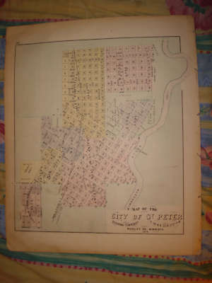
$3.75 Shipping Location: Winter Springs, United States Click Here. Double your traffic. Get Vendio Gallery- Now FREE! ANY UNUSUAL SHADOWS OR FUZZINESS IS ON THE PHOTO ONLY. Vintage antique 1874 map. This is ... morethe finest map of this area I've ever seen. The condition is amazing. The map is 2 pages, and either side would frame and display nicely. One side is a fine antique handcolored map, titled map of Map of the City of St Peter, Oshawa Township, Nicollet Co, Minnesota, 1874. I like how the year produced is right in the title, it dates the map nicely. Beautiful detailed map, the map shows the named addition, some land owners and more. Verso is a fine lithograph print page, 2 views at Mankato, one is Mankato House, a period large hotel, one is Sullivan& terrys Marble& Granite Works, and also 1 view at Mapleton Township, Blue earth County and 1 at Ceresco Twp, Blue Earth Co. This map would frame and display beautifully. This is an antique map and not a reprint or reproduction. The map is from the very rare 1874 Andrease Atlas of Minnesota, produced in 1874. The map is a fascinating and historic period look at this area at this time. The photo wont show the full beauty of the map. The map is in nice shape and would frame and display quite beautifully. The size of map is 14" by 17.5" Winning bidder pays $3.75 shipping domestic, more foreign. Payment I accept the following forms of payment: PayPal, Preferred Checkout For fastest processing of this order. Please use Vendio Checkout! Click to View Image Album Click to View Image Album Shipping& Handling $3.75 USPS First-Class Mail® FREE scheduling. Supersized images and templates. Get Vendio Sales Manager. FREE scheduling. Supersized images and templates. Get Vendio Sales Manager. Win more auctions at the last minute FREE. Learn how.
Buy It Now
$6.80 Shipping Location: Eagle, United States Presented is an authentic, old map taken from a dis-bound atlas published in 1874. Original hand color. Don't miss this opportunity to add to your collection. ... moreMap reverses to engravings of Blue Earth & Mankatu.
Buy It Now
$14.95 Shipping Location: Rochester, United States Map has ink advertising stamp of Nelson Weed Druggist, Albert Lea, Minn. Bound in salmon wrappers, title printed on cover. Statistics of Dakota and Minnesota ... moreoccupy the final two pages of this booklet.

Buy It Now
$3.95 Shipping Location: Clarkston, United States Rare Map Collection This DVD is part of our Historic Map and Atlas Collection. We have dozens of Atlas maps on DVD and CD ranging from the 1500s to the ... more1900s covering many areas and topics. Please Check our Ebay Store for what's available. FOR MANY MORE EDUCATIONAL CD TITLES ON THIS AND MANY OTHER SUBJECTS PLEASE VISIT OUR EBAY STORE VERY LARGE HIGH RESOLUTION MAP COLLECTION ON DVD! please see full table of contents and sample illustrations below) This DVD Contains 181 Maps of Minnesota Including 44 PANORAMIC MAPS of various Minnesota Cities These are scans of the ORIGINAL maps by various Cartographers. on DVD System requirements PC or Mac compatible. Files are simple PDF files with a basic HTML interface(just like viewing a webpage) Works with ALL versions of Windows. Maps of Minnesota An illustrated historical atlas of the state of Minnesota. An illustrated historical atlas of the state of Minnesota. An illustrated historical atlas of the state of Minnesota. Outline map of Minneapolis and St. Paul. 1897 Chippewa National Forest. Minnesota/ U.S. Department of Agriculture, Forest Service. 1994 Railroad and post office map of Minnesota and Wisconsin. 1871 Township and railroad map of Minnesota published for the Legislative Manual. 1874. Minneapolis and Saint Anthony. Minnesota 1867. Drawn by A. Ruger. 1867 Davisons map 25 miles around Minneapolis 1881. Map showing the Burlington Cedar Rapids and Minnesota Railway and its connections. 1868 Map of Winona County. Minnesota. 1867. Minneapolis. Minnesota. W. V. Herancourt, del. 1885 View of St. Paul. Minnesota. By Geo. Ellsbury and Vernon Green. 1874 Panoramic view of the city of Red Wing. Goddhue[sic] Co. Minnesota, 1880/ Shober& Carqueville, Lith. Co. Carte de la riviere Longue: et de quelques autres. Qui se dechargent dans le grand fleuve de Missisipi[sic] Carte que les Gnacsitares: ont dessine sur des paux de cerfs 1703 Bird's eye view of the city of Mankato. Blue Earth County, Minnesota 1870. Merchants Lithographing Co. 1883 bird's eye view of L

Buy It Now
$3.95 Shipping Location: Clarkston, United States Coins of India Reference Library This CD is part of our Historic Atlas Collection. We have dozens of Atlas maps on CD ranging from the 1500s to the 1900s ... morecovering many areas and topics. Please Check our Ebay Store for what's available. VERY LARGE HIGH RESOLUTION MAP COLLECTION ON CD-ROM! please see full table of contents and sample illustrations below) Title of this Atlas: An illustrated historical atlas of the State of Minnesota Published by A.T. Andreas. Lakeside 1874 Features of this CD-ROM This auction is for a CD-ROM of the maps listed in electronic form. NOT the maps themselves. These maps are VERY high resolution and can be printed at FULL SCALE or LARGER for framing and display. The results are very high quality and convincing The files are in PDF format for easy of viewing and printing. Maps can be viewed and many scales and zoom features are available as with any PDF file. 3034B 3034C 3034D 3034E 3034F 3034001 Topographical map of the United States. 3034002 Map of the State of Minnesota. 1874. 3034003 Western Hemisphere. Eastern Hemisphere. 3034004 Geological map of Minnesota by N.H. Winchell. State Geologist. with maps) Colored to show senatorial. judicial(and) congressional districts. 3034005 Population. United States Census, 1870: Density, foreign, colored, British American, Swedish and Norwegian. 3034006 Agricultural productions colored. to show quantity raised. wheat. Hay, corn, cotton, tobacco. 3034007 Vital statistics. United Census, 1870: Deaths from. diseases. 3034008 Saint Paul Press Company. Publishers of the Saint Paul Press. 3034009 The daily. Weekly and tri-weekly St. Paul Pioneer. 3034010"Eichenwald. residence of J.M. Keller, with residences of) E.S. Goodrich, Monroe Sheire, James T. Alley, T.M. Newson, St. Paul, Minn. 3034011 View of Assumption Church. St. Paul, Minn. 3034012 St. Paul. Minn. 3034013 Pacific Marble& Granite Works. Ingersoll Block, Cochran& Walsh, St. Paul; Anthony Kelly, Grocer, Minneapolis. 3034014 Plan of the City of St. Paul and vici
Buy It Now
$14.99 Shipping Location: Ivanhoe, Australia Handtke, Friedrich 1815 - 1879. - Royal Prussian Card. Province of Saxony, the duchy of Anhalt, the ducal. Saxon countries Weimar, Altenburg u. Gotha ... moreand the principals Schwarzburg and Reuss, Flemming, Glogau 1870/71.
|
|
|
In
|
LAND ATLAS AND PLAT BOOK BLUE EARTH COUNTY MINNESOTA 1962-SEPERATE MAP
52 PAGES. SPONSORED BY DIFFERENT ADVERTISERS.
|
|
|
Minnesota Blue Earth County Lincoln Township Map 1914
Here is a Original 1914 Blue Earth Lincoln Township Map. Map is 14 1/2 X17 1/2 inches in size, in excellent bright colored condition, great for framing or checking genealogy, shows land owners& acres they owned at this time,shows route of Chicago St paul Minneapolis& Omaha Railroad, check scan, will combine S&H with other Maps good luck bidding
|
|
|
Minnesota Blue Earth County Ceresco Township Map 1914
here is a Original Blue Earth County Ceresco Township map. 14 1/2 X 17 1/2 inches in size in excellent bright colored condition, Great for framing or checking genealogy, shows names of land owners& amount of acres they owned in 1914. check scan. will combine S&H with other maps. good luck bidding.
|
|
|
Minnesota Blue Earth County Judson Township map Minnesota River Lily Lake
Here is a Original 1914 Blue Earth County Judson Township Map. This is not a reprint, Map is 14X17 1/2 inches in size in excllent bright colored condition, great for framing or checking genealogy, shows land owners Names& locations of Land& acres they owned in 1914, shows Judson city Route of Minnesota River, Lily Lake, Lake crystal, Rush Lake, Chicago St Paul Minneapolis& Omaha Railroad, Chicago Northwestern Railroad, will combine S&H with other Maps, good luck bidding.
|
|
|
Mankato Minnesota Section 14 Township Map from 1914 Blue Earth County Atlas
Here is a original 1914 Blue Earth County Mankato Township Section 14 Map map is 14 1/2 X 17 1/2 inches in size. In excellent bright colored condition, great for framing or genealogy, shows landowners& land they owned in 1914, also shows route of Minnesota& Blue Earth Rivers through town, shows Riverside Addition, Sibley Park, Sibley Mound, Givens& Lewis Additions.Check scan will combine S&H with other maps. good luck bidding.
|
|
|
1952 blue earth county Minnesota plat book
Blue Earth County Minnesota plat book. 1952. 60 pages.
|
|
|
Blue Earth County Atlas & Plat Book Minnesota 1914 w/40+ Maps & 20p Ads & Photos
Blue Earth County Atlas& Plat Book Minnesota 1914 w/40+ Maps& 20p Ads& Photos Publisher Ogle 1914. See the cover page. Seems complete for Blue Earth, I looked at the different county. City, and township maps. Doesn't seem to have a US. World or state map. The principal city is Mankato. Lots and lots of pages of local advertising and photos Cover is loose. See the last picture. Pages are clean and not marked up. Nor water-stained. Nice 4-part color on the city/town maps. Cities and towns. Amboy. Eagle Lake. Good Thunder. Lake Crystal. Madison Lake. Mankato. Mapleton. Minnesota Lake† North Mankato† Pemberton. Skyline. St. Clair. Vernon Center. Beauford Township. Butternut Valley Township. Cambria Township. Ceresco Township. Danville Township. Decoria Township. Garden City Township. Jamestown Township. Judson Township. Le Ray ... moreTownship. Lime Township. Lincoln Township. Lyra Township. Mankato Township. Mapleton Township. McPherson Township. Medo Township. Pleasant Mound Township. Rapidan Township. Shelby Township. South Bend Township. Sterling Township. Vernon Center Township.
|
|
|
1914 Blue Earth Minnesota County atlas plat book Hard Cover
15 1/2 x 18 and 154 pages. This plat book is chucked full of information about the county. Mankato is a large city in Blue Earth. Book shows land owners. Has patron directory, pages of illustrations(113-131) also shows where buildings were. Overall book is in very good condition. Corners very lightly rubbed and colors are vivid. A rare plat book. Located in south central Minnesota
|
|
|
Minnesota Blue Earth County Eagle Lake city Map 1914
Here is a 1914 Blue Earth County Eagle lake City Map 14X17 inches in size. Great for framing or checking genealogy shows Land owners& Land they owned in 1914, shows location of Chicago Northwestern Railroad route& more, and many other Roads of 1914, check scan, will combine S&H with other maps, good luck bidding.
|
|
|
Minnesota Blue Earth County South Bend Township city Map 1914 T 108 N. R. 27 W
Here is a 1914 Blue Earth County South Bend City Township Map T. 108 N. R. 27 W. 14X17 inches in size. Great for framing or checking genealogy shows Land owners& Land they owned in 1914, shows location of Minnesota River Blue Earth River Fox lake, also shows Railroad Lines, Church's, School Districts& more, and many other Roads of 1914, check scan, will combine S&H with other maps, good luck bidding.
|
|
|
Minnesota Blue Earth County Cities of Mapleton & Garden City 1914 Map
Here is a 1914 Blue Earth County Map of Cities of Mapleton& Garden City Minnesota 17X29 inches in size Map. Great for framing or checking genealogy shows Land owners& Land they owned in 1914, shows location of, Chicago Milwaukee RR Line, Wantonwan River& more, and many other Roads of 1914, check scan, will combine S&H with other maps, good luck bidding.
|
|
|
Minnesota Blue Earth County Mapleton Township 105 Range 26 W Of 5th PM 1914 Map
Here is a 1914 Blue Earth County Mapleton Township 105 North Range 26 West of the 5th M.P. 14X17 inches in size Map. Great for framing or checking genealogy shows Land owners& Land they owned in 1914, shows location of City of Mapleton, Chicago Milwaukee RR Line, Maple River, Laura Lake& more, and many other Roads of 1914, check scan, will combine S&H with other maps, good luck bidding. g6.RcmdId ViewItemDescV4,RlogId p4%60bo7%60jtb9%3Fuk%601d72f%2B%3Eg6%3E-14afa69fa7e-0x10a-
|
|
|
Minnesota Blue Earth County Mankato Section 7 Township city Map 1914
Here is a 1914 Blue Earth County Mankato City Township Map section 7 14X17 inches in size. Great for framing or checking genealogy shows Land owners& Land they owned in 1914, shows location of Minnesota River, also shows Railroad Lines, Church's, School Districts& more, and many other Roads of 1914, check scan, will combine S&H with other maps, good luck bidding.
|
|
|
MAP OF BLUE EARTH COUNTY MINNESOTA MANKATO DAILY FREE PRESS 38 X 43 IN.
WE COMBINE POSTAGE IF YOU BUY 2 OR MORE ITEMS WE HAVE BEEN BUYING AND SELLING ANTIQUES FOR 45 YEARS. ALL ITEMS WE SELL HAVE BEEN PUCHASED FROM PRIVATE PARTIES. I WILL DO MY BEST TO DESCRIBE THE ITEM. PLEASE EMAIL ME BEFORE YOU BID IF YOU HAVE QUESTIONS ABOUT AN ITEM. Powered by The free listing tool. List your items fast and easy and manage your active items.
|
|
 |