-
Christian Collectibles
-
Christian Sheet Music
-
Vatican Stamps
-
Vatican Coins & Paper Money
-
Antiques
-
Antiquities
-
Architectural & Garden
-
Decorative Arts
-
Ethnographic
-
Furniture
-
Maps, Atlases & Globes
-
United States (Pre-1900)
-
United States (1900-Now)
-
AK, HI
-
AL, FL, GA, MS, NC, SC
-
AR, IA, KS, LA, MO, NE
-
AZ, CA, CO, NM, NV, UT
-
CT, MA, ME, NH, RI, VT
-
DC, DE, MD, NJ, NY, PA
-
ID, OR, WA
-
IL, IN, MI, OH, WI
-
MN, MT, ND, SD, WY
-
OK, TX
-
VA, WV, KY, TN
-
Entire US
-
United States (Date Unknown)
-
Africa
-
Asia
-
Australasia/ Oceania
-
Canada
-
Central America/ Caribbean
-
Europe
-
India
-
Ireland
-
Mexico
-
Middle East
-
North America
-
South America
-
United Kingdom
-
Maps on CD
-
World Maps
-
Globes
-
Mixed Lots
-
Reproductions
-
Price Guides & Publications
-
Other
|
In
Order by: Available to: This site contains affiliate links for which I may be compensated
|
Buy It Now
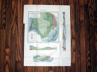
$6.95 Shipping Location: Dover, United States Issued 1874, New York by J. Bien. Map by Hitchcock and Walker. Map of the Coal Fields of the United States.
Buy It Now
$6.95 Shipping Location: Dover, United States Issued 1844, New York by Harper & Brothers. Engraved by Charles Copley. Mid 19th Century engraved map on bond paper with lovely hand color. Closed tear ... moreat right inset tab, any age flaws mostly minor and easy to overlook or forgive.
Buy It Now
$3.55 Shipping Location: Wichita, United States
Buy It Now
$13.85 Shipping Location: Dover, United States Geological Map of Wisconsin, Iowa, and Minnesota: Exhibiting, Also, the Extension of the Iowa Coal-Field in Missouri and its Relation to the Illinois ... moreCoal-Field.
Buy It Now
$3.50 Shipping Location: Shrewsbury, United States Rare, superb, circa 1870 fine antique color lithographed map, titled Map of the Coal Fields of The United States, New Brunswick and Nova Scotia, From ... moreJules Marcou. Printed at bottom middle is Chapman and Hall, London.
Buy It Now
$3.50 Shipping Location: United States This is the coal fields of the United States. Printed on fine paper with no printing in reverse. The size of the map is 6.75" by 10". Rare and fine map. ... moreFREE scheduling, supersized images.

Buy It Now
$9.97 Shipping Condition: Unspecified Location: LONDON, United Kingdom British Isles industries Antique colour map. 1907 Title of map: British Isles industries' The image below shows an enlarged cross section from the ... morecentre of the map to show the level of printed detail: DATE PRINTED: 1907 IMAGE SIZE: Approx 18.5 x 14.0cm. 7.25 x 5.5 inches(Medium) ARTIST/CARTOGRAPHER/ENGRAVER: Unsigned PROVENANCE: A School Atlas of English History" Edited by Samuel Rawson Gardiner; Published by Longmans. Green, Co. London. Please note that virtually all antique and vintage maps and prints have been extracted from books, atlases or newspapers. TYPE: Antique colour map VERSO: There is nothing printed on the reverse side. Which is plain CONDITION: Good; suitable for framing. Please check the scan for any blemishes prior to making your purchase. Virtually all antiquarian maps and prints are subject to some normal aging due to use and time which is not obtrusive unless otherwise stated. I offer a no questions asked return policy- see below. AUTHENTICITY: This is an authentic historic print. Published at the date stated above. I do not offer reproductions. It is not a modern copy. The term'original' when applied to a print means that it was printed at the first or original date of publication; it does not imply that the item is unique. Print' means any image created by applying an inked block to paper or card under pressure by any method including wood engraving, steel engraving, copperplate, wood cut and lithography. REMARKS: FRANCE: Gravures et Cartes anciennes. DEUTSCHLAND: Alte Lankarten und Stadt ansichten. ITALIA: Stampe& Mappe antiche. ESPAÑA: Mapas antiquos y impresiones antiguas. E and OE. Force Majeure. English law shall apply. RETURNS POLICY: I offer a no questions returns policy. All I ask is that you pay return shipping and mail back to me in original condition. Suitably packed& insured, within 14 days of receipt. 336.RcmdId ViewItemDescV4,RlogId p4%60bo7%60jtb9%3Fvo%7B%3Dd70f%2B%3E336-1440a42364c-0xf0-
Buy It Now
$5.35 Shipping Location: Colorado Springs, United States This antique map is titled, “Coal Fields Of The United States showing Coal-bearing formations”. It was published by the USGS in 1901. The map shows the ... morevarious coal field locations throughout the United States. It is color coded to show the type of coal found in each area. NOTE: the map is missing the bottom left portion of the border (see photos). Shipped with USPS First Class.
Buy It Now
$19.13 Shipping Location: TELFORD, United Kingdom Antique Victorian map of The Scotch Coal Fields - printed by William MacKenzie c1883. So do pop back! An original map, not a reproduction, from an 1880's ... moreencyclopaedia.
Buy It Now
$6.00 Shipping Location: Canada DATE OF ISSUE: 1972.
Buy It Now
$19.13 Shipping Location: TELFORD, United Kingdom Antique Victorian map of The Coal Fields of Great Britain printed by William MacKenzie c1883. So do pop back! An original map, not a reproduction, from ... morean 1880's encyclopaedia.
Buy It Now
$12.50 Shipping Location: Boulder, United States 56th Congress 1st Session, House of Representatives, Doc. The map is the topography of the San Carlos region showing locations described, the diagram ... moreis of columnar sections in the vicinity of Chispa and San Carlos.
Buy It Now
$6.95 Shipping Location: Dover, United States Issued c.1845, New York, by Harper & Brothers. Engraved by Charles Copley. A very uncommon/ scarce large old map by this engraver and publisher from Brooklyn, ... moreNY.
Buy It Now
$6.95 Shipping Location: Dover, United States Various pie charts add to the detail.
Buy It Now
$14.99 Shipping Location: Ivanhoe, Australia The earliest settlers in southeastern Schuylkill County, which was then part of Northampton County, were primarily Moravian missionaries from Saxony. ... moreOther early settlers in southern Schuylkill County were German Palatines.
Buy It Now
$11.85 Shipping Location: Dover, United States Issued 1846, London by Longman. Engraved by S. Hall. Beautiful mid-19th century antique map, with lovely hand color. Printed on thin bond paper.
Buy It Now
$3.50 Shipping Location: Easton, United States "Map of Part of the Camden Coal Field Showing Crop of Coal and Location of Mines and Prospects. Light toning, heavier on the edges. A tear in the map ... moretop left side-repairable. Date: 1899.
Buy It Now
$9.96 Shipping Location: GLASGOW, United Kingdom We do not deal in facsimiles or reproductions of any kind.

Buy It Now
$9.97 Shipping Condition: Unspecified Location: LONDON, United Kingdom The World's Commodities- 14. The Coalfields of the World; Coalfields of the British Isles; Petroleum Colour antique map. 1907 Title of map: The World's ... moreCommodities- 14. The Coalfields of the World; Coalfields of the British Isles; Petroleum' The image below shows an enlarged cross section from the centre of the map to show the level of printed detail: DATE PRINTED: 1907 IMAGE SIZE: Approx 19.5 x 23.5cm. 7.75 x 9.25 inches(Medium) ARTIST/CARTOGRAPHER/ENGRAVER: Unsigned PROVENANCE: The Harmsworth Atlas and Gazetteer" Published at Carmelite House, London. Please note that virtually all antique and vintage maps and prints have been extracted from books, atlases or newspapers. TYPE: Colour antique map VERSO: There are images and/or text printed on the reverse side of the picture. In some cases this may be visible on the picture itself(please check the scan prior to your purchase) or around the margin of the picture CONDITION: Good; suitable for framing. Please check the scan for any blemishes prior to making your purchase. Virtually all antiquarian maps and prints are subject to some normal aging due to use and time which is not obtrusive unless otherwise stated. I offer a no questions asked return policy- see below. AUTHENTICITY: This is an authentic historic print. Published at the date stated above. I do not offer reproductions. It is not a modern copy. The term'original' when applied to a print means that it was printed at the first or original date of publication; it does not imply that the item is unique. Print' means any image created by applying an inked block to paper or card under pressure by any method including wood engraving, steel engraving, copperplate, wood cut and lithography. REMARKS: FRANCE: Gravures et Cartes anciennes. DEUTSCHLAND: Alte Lankarten und Stadt ansichten. ITALIA: Stampe& Mappe antiche. ESPAÑA: Mapas antiquos y impresiones antiguas. E and OE. Force Majeure. English law shall apply. RETURNS POLICY: I offer a no questions returns policy. All I ask is
Buy It Now
$4.25 Shipping Location: Watertown, United States Historic Geologic Map Costigan Coal Field- Alberta, Canada 1905 Original"Geological Map of Costigan Coal Field Alberta" Paper map measuring ... moreapproximately 19 1/2" x 26" Very good condition with slight creasing from previous folding and few pencil notes on back. Otherwise clean and bright. Color coded for geologic deposits with two cross-section views and stereogram view of coal field from the southeast. This is a nice copy of a rare map. Title and Publication info reads: Geological Map of Costigan Coal Field. Alberta. 1905. Published by the Geological Survey of Canada. Robert Bell. Acting Director. Drawn from photolithography by Paul Frerault. To accompany Part A, Vol. XVI. No. 892 NO RESERVE! Check Out My Other Auctions for Many More Historic Maps Please email with any questions or request for additional photos before you bid. All maps are shipped via U.S. Postal Service. Additional charges apply if insurance or any other shipping method is requested. Will ship worldwide. Shipping charges listed only to addresses in U.S. and Canada- all others inquire as to shipping costs. All sales are final with returns granted only if item is not as described. Refunds given for cost of item only and only after returned item is received by seller in same condition as it was sent. Buyer assumes all charges for returned items. Including initial shipping cost, insurance if requested, and return postage and insurance(return insurance is required) If you have concerns, please request insurance. IC: TDM 022] Powered by The free listing tool. List your items fast and easy and manage your active items.
Buy It Now
$8.50 Shipping Location: Croatia The coalfield lies in southeastern Ukraine and in the adjoining region of southwestern Russia. The principal exploited area of the field covers nearly ... more9,000 square miles (23,300 square km) south of the Donets River, but coal deposits also extend westward to the Dnieper River in the greater Donets Basin.
Buy It Now
$20.00 Shipping Location: Aurora, United States Scale 1: 500,000. It outlines Tertiary Lake Beds, Livingstone Trail Creek Field, Lombard Field,and the coal rich Great Falls Bed. National Forests, Mountain ... moreRanges, Rivers, and lakes are also shown.
Buy It Now
$4.69 Shipping Location: Greenacres, United States It is identified as the 1909 edition of the Earlington quadrangle, based on surveys in 1907. It is listed as item # 224408328657. Genuine original color ... morelithographed fold-out dissected topographical map of parts of Hopkins and Webster counties in the Western Coal Fields region of Kentucky, printed more than 110 years ago.
Buy It Now
$5.50 Shipping Location: Easton, United States Pennsylvania Coal Fields". _gsrx_vers_1426 (GS 9.0.3 (1426)).

Buy It Now
$9.97 Shipping Condition: Unspecified Location: LONDON, United Kingdom Map of the Coalfields of Great Britain showing the areas of exposed and concleaed coal measures Antique coloured map. 1898 Title of map: Map of the Coalfields ... moreof Great Britain showing the areas of exposed and concleaed coal measures' The image below shows an enlarged cross section from the centre of the map to show the level of printed detail: DATE PRINTED: 1898 IMAGE SIZE: Approx 25.5 x 19.5cm. 10 x 7.75 inches(Medium) ARTIST/CARTOGRAPHER/ENGRAVER: Unsigned PROVENANCE: The Encyclopaedia Britannica" Published by Edinburgh: Adam& Charles Black. London; 9th Edition TYPE: Antique coloured map VERSO: There is nothing printed on the reverse side. Which is plain CONDITION: Good; suitable for framing. However. Please note: The image shown may have been taken from a different example of this map than that which is offered for sale: any flaws described in this statement may not be visible on the image but will be present on the map you receive. Please check the scan for any blemishes prior to making your purchase. Virtually all antiquarian maps and prints are subject to some normal aging due to use and time which is not obtrusive unless otherwise stated. I offer a no questions asked return policy- see below. AUTHENTICITY: This is an authentic historic print. Published at the date stated above. I do not offer reproductions. It is not a modern copy. The term'original' when applied to a print means that it was printed at the first or original date of publication; it does not imply that the item is unique. Print' means any image created by applying an inked block to paper or card under pressure by any method including wood engraving, steel engraving, copperplate, wood cut and lithography. REMARKS: FRANCE: Gravures et Cartes anciennes. DEUTSCHLAND: Alte Lankarten und Stadt ansichten. ITALIA: Stampe& Mappe antiche. ESPAÑA: Mapas antiquos y impresiones antiguas. E and OE. Force Majeure. English law shall apply. RETURNS POLICY: I offer a no questions returns policy. All I ask is that you pay retu
Buy It Now
$4.69 Shipping Location: Greenacres, United States It was compiled by the Swiss geographer and Princeton professor Arnold Henry Guyot and published by Charles Scribner's Sons, New York in Guyot'sPhysical ... moreGeography.

Buy It Now
$10.00 Shipping Location: Chicago, United States USA View postcard. Please check my ebay store for many more view postcards. I am putting more and more items directly into the eBay store check here for ... moremore cards. Find more great cards in my daughters eBay store PLEASE READ: SHIPPING: I do combine shipping. I only charge a flat rate no matter how many cards you buy. It is $2.50 for USA and Canada and $5 for overseas. If ebay charges you more. Ask for an invoice BEFORE paying your bill. If I have to refund excessive postage I have to pay fees on that so please ask first. CONDITION NEW-USED. EBay only gived me two option like I was selling t-shirts. So I will always select used even if the postcard is mint because when I select new beginning collectors think it is a reproduction. I do NOT sell reproduction. If the card is less than 30 years old I will use the word MODERN in the title. FEEDBACK: I guarantee my items. If you are unhappy for any reason you may return your item for a refund, no questions asked. Enjoy shopping with a reliable dealer with 40 years of experience, and read my book The Encyclopedia of Antique Postcards. Over 20,000 copies were sold. check your local library or on line for a copy. We all appreciate positive feedback. Five stars gives the seller an opportunity to sell postcards at lower costs. If you are unhappy with something, contact me first so we can correct the problem and I earn my five stars. Powered by The free listing tool. List your items fast and easy and manage your active items.
Buy It Now
$3.75 Shipping Location: United States Beautiful color lithography, printed on thick paper. On reverse is detialed period text and related history to these areas, with photos as well. The size ... moreof the map is 14" by 19". FREE scheduling, supersized images.
Buy It Now
$13.00 Shipping Location: Rockville, United States Published in 1843 by Harper & Brothers, New York. The map was engraved by Charles Copley. Map is generally in Fair condition. There are several creases ... morein the map, where it has been folded within the book.
Buy It Now
$6.95 Shipping Location: Dover, United States Very scarce mid-19th century large folio map printed on thin bond paper. Clean 4" tear at right edge from top fold line closed neatly on back with thin ... moretissue paper. This is easy to overlook or forgive visually.
Buy It Now
$44.99 Shipping Location: Ivanhoe, Australia The map shows New South Wales' new (and current) boundaries, with the state's 'Pastoral Districts' delineated; railways from Ports Hunter and Jackson ... moreare shown, along with their proposed extensions inland.

Buy It Now
$3.50 Shipping Location: Clarkston, United States Rare Map Collection This DVD is part of our Historic Map and Atlas Collection. We have dozens of Atlas maps on DVD and CD ranging from the 1500s to the ... more1900s covering many areas and topics. Please Check our Ebay Store for what's available. FOR MANY MORE EDUCATIONAL CD TITLES ON THIS AND MANY OTHER SUBJECTS PLEASE VISIT OUR EBAY STORE VERY LARGE HIGH RESOLUTION MAP COLLECTION ON DVD! please see full table of contents and sample illustrations below) This DVD Contains 140 Maps of West Virginia Including 29 PANORAMIC MAPS of various West Virginia Cities These are scans of the ORIGINAL maps by various Cartographers. on DVD System requirements PC or Mac compatible. Files are simple PDF files with a basic HTML interface(just like viewing a webpage) Works with ALL versions of Windows. Maps of West Virginia 3565087 Rand McNally and Company Date: 1897 Short Title: West Virginia. 4190000 Richardson. C.S. Date: 1864 Short Title: Richardson's Map Of West Virginia. 4975106 Hayes. Eli L. Date: 1877 Short Title: Point Pleasant. Mason Co. West Va. with) West Columbia, Clifton, W. Va. 4975111 Hayes. Eli L. Date: 1877 Short Title: Huntington. Cabell Co. W. Va. 4975113 Hayes. Eli L. Date: 1877 Short Title: Ceredo. Wayne Co. 1st Dist. W. Va. with) Catlettsburg, Boyd Co. Ky. ar300700 Washington. George, 1732-1799. Main Title: Plat of a survey for William Hughes. Jr. of 460 acres in Frederick County, Va. on the Cacapon River] 1750. ct000363 Washington. George, 1732-1799. Main Title: Eight survey tracts along the Kanawha River. W.Va. showing land granted to George Washington and others. 1774? ct000592 West Virginia Geological Survey. Main Title: Soil map: West Virginia. Boone county sheet. Baltimore: A. Hoen& Co. 1913. ct000593 Swann. John S. Main Title: Title map of the coal field of the great Kanawha Valley. New York: G.W. C.B. Colton. 1867. ct000594 Hotchkiss. Jedediah, 1828-1899. Main Title: Map of Great Kanawha coal field showing location of mines. Staunton. Va. 1886. ct000595 Chesapeake and Ohio Railroad C
Buy It Now
Free Shipping Location: Saugerties, United States Division of the State Geological Surveys. #23 Manganese Deposits of Western Virginia - 1922; 1 Large Map of Western Virginia and One Chart. #12 The Coal ... moreResources of the Clintwood and Bucu Quadrangles.
$3.95 Shipping Location: Clarkston, United States 1898 Alaska Geological Gold and Cole Survey Map. to the headwaters of the Yukon River, Alaska. Includes parts of the Yukon Territory and northern British ... moreColumbia. This is a reproduction of the original map.
Buy It Now
$9.97 Shipping Condition: Unspecified Location: LONDON, United Kingdom DATE PRINTED: 1920. CONDITION: Good; suitable for framing. AUTHENTICITY: This is an authentic historic print, published at the date stated above. It is ... morenot a modern copy.
Buy It Now
$4.69 Shipping Location: Greenacres, United States It is identified as the 1909 edition of the Madisonville quadrangle, based on surveys in 1907 and printed in 1927. Genuine original color lithographed ... morefold-out dissected topographical map of parts of Hopkins, McLean, and Muhlenberg counties in the Western Coal Fields region of Kentucky, printed more than 90 years ago.
Buy It Now
$11.84 Shipping Location: ILKLEY, United Kingdom Text in German. Provenance: 'Adolf Stieler's Hand Atlas uber Alle Theile der Erde und Uber das Weltgebaude', 1886 edition. Title / Subject: Northern Germany ... more(inset map of the Ruhr Coalfields).
Buy It Now
$8.50 Shipping Location: Croatia Modern industries include tanning, food processing, and the manufacture of plastic pipe, elastic webbing, and apparel. Inc. 1890. (2000) 10,384; (2010) ... more10,334.
Buy It Now
Free Shipping Location: Sielow, Germany Map collector (all-encompassing...especially German affordable maps from 1900) sells his double copies of the school wall maps here (wall map wall maps ... moreroll wall map roll map), questions are happy to be answered, price comparison for new wall maps e.g. under Westermann de I also buy large lots (from approx. 30 - 50 - 100 pieces of school wall cards, depending on the distance to me, effort!), call me... Intended use: children's room, teenager's room, traditional room, men's room, classroom, hallway, auditorium, for information, discussion with children, students, travelers, parents, grandparents, friends, etc. or for your own mental flight into the time and area of the card's content. You usually only need something to hang it up (if necessary, the lamp in the room), as many cards have a.

Buy It Now
$9.97 Shipping Condition: Unspecified Location: LONDON, United Kingdom North America(Industrial) Inset map of Delta of the Mississippi Vintage colour map. 1920 Title of map: North America(Industrial) Inset map of Delta of ... morethe Mississippi' The image below shows an enlarged cross section from the centre of the map to show the level of printed detail: DATE PRINTED: 1920 IMAGE SIZE: Approx 34.0 x 45.0cm. 13.25 x 17.5 inches(Large) ARTIST/CARTOGRAPHER/ENGRAVER: Unsigned PROVENANCE: Harmsworth's new Atlas" Please note that virtually all antique and vintage maps and prints have been extracted from books. Atlases or newspapers. TYPE: Vintage colour map VERSO: There is interesting related text and images printed on the reverse side of the picture. The paper is thick. And the verso text does not show through to the front of the map CONDITION: Good; suitable for framing. However. Please note: This map was originally printed as two separate pages which have been professionally joined to form a single sheet. Please check the scan for any blemishes prior to making your purchase. Virtually all antiquarian maps and prints are subject to some normal aging due to use and time which is not obtrusive unless otherwise stated. I offer a no questions asked return policy- see below. AUTHENTICITY: This is an authentic historic print. Published at the date stated above. I do not offer reproductions. It is not a modern copy. The term'original' when applied to a print means that it was printed at the first or original date of publication; it does not imply that the item is unique. Print' means any image created by applying an inked block to paper or card under pressure by any method including wood engraving, steel engraving, copperplate, wood cut and lithography. REMARKS: FRANCE: Gravures et Cartes anciennes. DEUTSCHLAND: Alte Lankarten und Stadt ansichten. ITALIA: Stampe& Mappe antiche. ESPAÑA: Mapas antiquos y impresiones antiguas. E and OE. Force Majeure. English law shall apply. RETURNS POLICY: I offer a no questions returns policy. All I ask is that you pay return shippin
Buy It Now
$9.97 Shipping Condition: Unspecified Location: LONDON, United Kingdom Antique folding hand coloured survey map, dissected and laid down on linen, 1840. DATE PRINTED: 1840. AUTHENTICITY: This is an authentic historic print, ... morepublished at the date stated above. It is not a modern copy.
Buy It Now
$9.97 Shipping Condition: Used Location: LONDON, United Kingdom 'Coal Basins'. Title of map:'Coal Basins'. Antique engraved sketch map, 1885. DATE PRINTED: 1885. TYPE: Antique engraved sketch map. CONDITION: Good; ... moresuitable for framing. VERSO: There are images and/or text printed on the reverse side of the picture.
Buy It Now
$9.97 Shipping Condition: Used Location: LONDON, United Kingdom Antique engraved sketch map, 1885. DATE PRINTED: 1885. TYPE: Antique engraved sketch map. CONDITION: Good; suitable for framing. VERSO: There are images ... moreand/or text printed on the reverse side of the picture.
Buy It Now
$14.95 Shipping Location: MARKET HARBOROUGH, United Kingdom 100% ORIGINAL LARGE GEOLOGICAL NORTHUMBERLAND DURHAM COALFIELDS MAP. MAP IN VERY GOOD CONDITION NO TEARS NO REPAIR.

Buy It Now
$9.97 Shipping Condition: Unspecified Location: LONDON, United Kingdom Germany(West) Inset Westphalian Coalfields; Leipzig; Munich Vintage colour map. 1920 Title of map: Germany(West) Inset Westphalian Coalfields; Leipzig; ... moreMunich' The image below shows an enlarged cross section from the centre of the map to show the level of printed detail: DATE PRINTED: 1920 IMAGE SIZE: Approx 34.0 x 45.0cm. 13.25 x 17.5 inches(Large) ARTIST/CARTOGRAPHER/ENGRAVER: Unsigned PROVENANCE: Harmsworth's new Atlas" Please note that virtually all antique and vintage maps and prints have been extracted from books. Atlases or newspapers. TYPE: Vintage colour map VERSO: There is interesting related text and images printed on the reverse side of the picture. The paper is thick. And the verso text does not show through to the front of the map CONDITION: Good; suitable for framing. However. Please note: This map was originally printed as two separate pages which have been professionally joined to form a single sheet. Please check the scan for any blemishes prior to making your purchase. Virtually all antiquarian maps and prints are subject to some normal aging due to use and time which is not obtrusive unless otherwise stated. I offer a no questions asked return policy- see below. AUTHENTICITY: This is an authentic historic print. Published at the date stated above. I do not offer reproductions. It is not a modern copy. The term'original' when applied to a print means that it was printed at the first or original date of publication; it does not imply that the item is unique. Print' means any image created by applying an inked block to paper or card under pressure by any method including wood engraving, steel engraving, copperplate, wood cut and lithography. REMARKS: FRANCE: Gravures et Cartes anciennes. DEUTSCHLAND: Alte Lankarten und Stadt ansichten. ITALIA: Stampe& Mappe antiche. ESPAÑA: Mapas antiquos y impresiones antiguas. E and OE. Force Majeure. English law shall apply. RETURNS POLICY: I offer a no questions returns policy. All I ask is that you pay return shipping and ma
Buy It Now
$19.94 Shipping Location: CHRISTCHURCH, United Kingdom Coal Deposits and Electric Power Industry of Timan Pechora Fuel and Energy Complex. Coal Regions of Kuznetsk Basin. Coal Deposits of Eastern Siberia. ... moreCoal Content of Kansk Achinsk Fuel and Energy Complex.
Buy It Now
$9.96 Shipping Location: GLASGOW, United Kingdom Provenance: Taken From the Harmsworth New Atlas. We do not deal in facsimiles or reproductions of any kind. We grade all prints individually into four ... morelevels - Excellent, Very Good, Good, and Fair.
Buy It Now
$12.85 Shipping Location: Rochester, United States See also: List of artists and writers from Alaska. A dog team in the Iditarod Trail Sled Dog Race, arguably the most popular winter event in Alaska. Alaska ... moreMining District. Alaska Interstate Highways.
Buy It Now
$9.97 Shipping Condition: Unspecified Location: LONDON, United Kingdom 'Germany (West); Inset map of Westphalian Coalfields; Leipzig'. Title of map:'Germany (West); Inset map of Westphalian Coalfields; Leipzig'. DATE PRINTED: ... more1920. AUTHENTICITY: This is an authentic historic print, published at the date stated above.
Buy It Now
$9.97 Shipping Condition: Used Location: LONDON, United Kingdom 'The Coal-field of Charleroi'. Title of map:'The Coal-field of Charleroi'. Antique engraved sketch map, 1885. DATE PRINTED: 1885. TYPE: Antique engraved ... moresketch map. CONDITION: Good; suitable for framing.
Buy It Now
$8.50 Shipping Location: Croatia City, southwestern British Columbia, Canada, on Vancouver Island and the Georgia Strait. An important distributing centre, Nanaimo is connected with Vancouver ... moreand the mainland by ferries. Coal mining was the chief industry until the last mine closed in 1953.
Buy It Now
Free Shipping Location: Sielow, Germany here comes if necessary. the list of my cards as well, for your information, probably not for sale or irresistible offers, most flashcards (not maps) ... morecan be safely purchased all search terms for the Excel list: IGN Perthes Haack Darmstadt Flemming Klasing Gaebler Gotha Westermann etc. and the following titles Development of the brain Grass snake Domestic pigeon Europe at the time of migration and state formation (375-580) Europe at the time of HohenstaufenFriedrich 2. (1212-50) Europe Economy Economic map Europe from 1815-1871 Europe after World War II World War 1945-1970 Europe in the XXth century 4xpol Europe in the 18th century Century Europe in the 16th century Century 1580 Europe Mining and industry Europe 1919-1945 Europe 1919-1937 Europe 1918-1937 3NK Europe 1871-1914 Europe 1848-18.
Buy It Now
$18.95 Shipping Location: YORK, United Kingdom A LARGE 1950's SINGLE PAGE MAP Over 50 years old and in excellent condition Large size and printed on quality paper A fascinating and unusual map. Ideal ... morefor framing There will be another map/part map on the reverse Approximately 20 inches x 15 inches Please message with any questions regarding this item BEST OFFERS PLEASE FOR A QUICK SALE AT A FAIR PRICE If you like the item, but do not like the price, then make a realistic offer to us using the MAKE OFFER BUTTON.
Buy It Now
$9.97 Shipping Condition: Used Location: LONDON, United Kingdom 'The Raniganj Mines'. Title of map:'The Raniganj Mines'. Antique engraved sketch map, 1885. DATE PRINTED: 1885. TYPE: Antique engraved sketch map. CONDITION: ... moreGood; suitable for framing. VERSO: There are images and/or text printed on the reverse side of the picture.
Buy It Now
$11.84 Shipping Location: ILKLEY, United Kingdom An original antique, copper-engraved map of North West Germany with an inset map of the Ruhr Coalfields, published in c.1880 in Adolf Stieler’s ‘Hand ... moreAtlas uber alle Theile der Erde und uber das Weldgebaude ’ by the Justus Perthes publishing house in Gotha.
Buy It Now
$18.95 Shipping Location: YORK, United Kingdom A VINTAGE MAP OVER 75 YEARS OLD This map is from a collection produced for The serial map service Atlas 1939 THIS LISTING IS FOR THE SINGLE MAP SHOWN ... more Approximate size of this FOLD-OUT map ~ 510mm x 380mm ****CONDITION**** PLEASE VIEW IMAGES TO SEE ANY HANDLING/AGE MARKS /REPAIRS/DAMAGE/EXTENT OF MARGINS etc Please message with any questions regarding this item BEST OFFERS PLEASE FOR A QUICK SALE AT A FAIR PRICE If you like the item, but do not like the price, then make a realistic offer to us using the MAKE OFFER BUTTON (1939-RED) Powered by eBay Turbo Lister.
Buy It Now
$14.95 Shipping Location: Rochester, United States Map has ink advertising stamp of Nelson Weed Druggist, Albert Lea, Minn. Bound in salmon wrappers, title printed on cover. Statistics of Dakota and Minnesota ... moreoccupy the final two pages of this booklet.
Buy It Now
Free Shipping Location: Sielow, Germany here comes if necessary. the list of my cards as well, for your information, probably not for sale or irresistible offers, most flashcards (not maps) ... morecan be safely purchased all search terms for the Excel list: IGN Perthes Haack Darmstadt Flemming Klasing Gaebler Gotha Westermann etc. and the following titles Development of the brain Grass snake Domestic pigeon Europe at the time of migration and state formation (375-580) Europe at the time of HohenstaufenFriedrich 2. (1212-50) Europe Economy Economic map Europe from 1815-1871 Europe after World War II World War 1945-1970 Europe in the XXth century 4xpol Europe in the 18th century Century Europe in the 16th century Century 1580 Europe Mining and industry Europe 1919-1945 Europe 1919-1937 Europe 1918-1937 3NK Europe 1871-1914 Europe 1848-18.
Buy It Now
Free Shipping Location: Sielow, Germany They each bid on 1 card (according to Image original photo of the respective offer), shipping costs are calculated exclusively from the shipping weight ... morevia a special shipper for large piece goods. put something together in peace and quiet West German publishers mostly have wooden sticks, see partial item description, damage is also mentioned where possible, if the hadü suspension/fastening is needed, please if necessary. Please ask or let me know if necessary. I reserve the right to dismantle inadequate/wobbly hooks; what is not on it cannot be broken or interfere with transport, and I may have. a hook for free use Purpose: children's room, teenager's room, traditional room, men's room, classroom, hallway, auditorium, for information, discussion with children, students, travelers, parents,.
|
|
|
In
|
ALASKA (AK) GOLD & COAL FIELDS MINING MAP 1898 MOTP
This is an exquisite full-color Reproduction printed on heavyweight(7.0 MIL) Glossy Photo Paper. These maps are perfect for framing. Or a wonderful and unique gift for family members, friends or co-workers! All Information is Carefully Compiled from Actual Surveys Original Maps are often difficult to find and usually have fold lines. Identifying stamps or markings, tears, ragged edges, and assorted other natural signs of age that detract from their beauty. All of our maps have been professionally restored to depict their original beauty, while keeping all historical data intact. These maps are fabulous pieces of history full of information useful to Historians. Genealogists, Cartographers, Relic Hunters, Others. They make fascinating conversation pieces and splendid works of art for the home or office. Map Size: 27.75 x 23 Site Specifics ... moreTo This Map Are: Mt. McKinley. Franklin Mountains, Fort St. Michael Military Reservation, Tanana Hills, Yukon Hills, Mount St. Elias, Mt. Sushita, Copper River Trail, Demarcation Point, Kotzebue Sound, Lewes River, Copper River, Admiralty Island, Teslin Lake, Nelson Lake, Senati Camp, Fort Reliance(Ruins) And the Old Reid House. The following towns are featured: Circle City. Dawson(Canada) Attemut, Skagway, Dyea, Juneau, Douglas, Chilkat, And Tikchik. This Map is Situated in: Yukon Northern District. Kodiak Southern District, and Southeastern Area at the time. SKU: AKZZ0002 and Powered By:
|
|
|
1878~BEAVER RIVER DISTRICT OF THE BITUMINOUS COAL-FIELDS OF WESTERN PENNSYLVANIA
An estate sale find. 337 pages + 21 pages of PLATES OF VERTICAL SECTIONS. Three maps = SOUTHERN BUTLER/ NORTH ALLEGHENY/ BEAVER COUNTY, some scuff marks on hardcover, Overall this item is in very good condition. See photos. Feel free to ask questions. BUYER TO PAY 4.00 SHIPPING IN THE U.S.
|
|
|
1929 CS HAMMOND & CO PENNSYLVANIA COAL FIELDS TOPOGRAPHIC GEOLOGICAL SURVEY MAP
Normal 0 false false false MicrosoftInternetExplorer4 Auction includes 1 1929 C.S. HAMMOND& CO"PENNSYLVANIA COAL FIELDS TOPOGRAPHIC& GEOLOGICAL SURVEY MAP" This item came from an estate in Western Pennsylvania. It is an original 34 3/4" x 55 1/2" large fold out topographic& geological survey map that features the coal/ anthracite fields of Pennsylvania. Please see pictures to help determine physical condition. Please contact us if you have any questions regarding condition. Additional photos etc, before bidding unless you are content with the pictures and information provided. We will be more than happy to help you: BIDDING INFORMATION: We have had several requests for second chance offers as well as bidders making offers on items that have closed because their bids were not placed in time or an error occurred. ... morePlease note. While we appreciate the interest in our listings, NO offer(regardless of how high it is) will be considered once the auction is closed& paid for. It would be unethical as well as against Ebay regulations. We suggest all interested bidders place their bids long before the auction ending. Placing a bid in the last few minutes of the auction may not secure your bid. Due to fraudulent bids all international bidders must contact us prior to bidding to confirm bidding eligibility as well as shipping& handling cost. Failure to do so may result in cancellation of bid and/or auction SHIPPING INFORMATION: There is no problem combining shipping with other items purchased. However please contact us first to determine pricing. We ship our items twice a week so please allow 3 days for handling time. If you need the item to be shipped earlier please contact us& we will be happy to work out a solution for you. International bidders. Please keep in mind that orders shipped via USPS First Class Mail International can sometimes take 4-8 weeks for delivery. Shipping with the Global Shipping Program through eB ay is usually much faster. If you do no t wish to use the Glo
|
|
|
1902 MAP: SOUTHERN ROCKY MOUNTAIN COAL FIELDS COLORADO NEW MEXICO BIEN LITHO.
Click to Enlarge Click to Enlarge 1902 ANTIQUE MAP: SOUTHERN ROCKY MOUNTAIN COAL FIELDS SHOWING CRETACEOUS COAL-BEARING FORMATIONS. BY J.L. STORRS. PUBLISHED BY THE GOVERNMENT PRINTING OFFICE. WASHINGTON, DC. IN 1902. Size: Approx 11.25 X 14.5 INCHES(ENTIRE SHEET) WONDERFUL LITHOGRAPH MAP FROM THE EARLY 20TH CENTURY. LITHOGRAPHY BY THE NOTED FIRM. JULIUS BIEN& CO. Condition: VERY GOOD. SEE PHOTO. Due to age. Small imperfections are to be expected. Please view the photos to make your own assessment. ONE FOLD IN CENTER, AS PUBLISHED. Returns: Any item may be returned for a refund. Please contact us within 14 days of receipt of your item if you feel an error has been made. We do not deal in modern reproductions. All of our prints& maps are original and authentic. Please browse other prints& maps at our store. Inv# 13-3-M inkfrog ... moreterapeak. I000000.
|
|
|
ANTHRACITE COAL FIELDS OF PENNSYLVANIA 1877 INSPECTOR OF MINES
This auction features this 1878 book entitled"Reports of the Inspectors of Mines of the Anhtracite Coal Regions of Pennsylvania for the year 1877" in great condition! It was published in Harrisburg in 1878 and cover the Mining District of Schuylkill which included the counties of Schuykill. Northumberland, Columbia and Daughin and was"To his Excellency John F Hartranft, Governor of Pennsylvania. It includes 6 tissue maps: The Anthracite Coal Fields of Pennsylvania, Wadesville Shaft Colliery, Plate 1, Plate 2, and Plate 3, Cross section through Bast Colliery tunnel, Map showing location of explosion in No 7 shaft, Plan of John Jermyn's mines Green Ridge Scranton, PA, Section of Bore Hole west of Gowen Colliery, Luzerne County, PA. All the tissue maps are still attached to the book and are in great condition; the one shown ... moreis the first and right inside the cover; is attached has a few more creases than the others. Many more illustrations and information from this coal boom for the area.Excellent condition for the age; binding is tight; no rips, tears or writing a few of the last pages have the corner creased. God Bless and Happy Bidding!
|
|
|
Map of China, Railways, Coal Fields, Mines, Waterways, 1900
Click to Enlarge Click to Enlarge Map of China Showing Railway Concessions. Coalfields, Iron Mines, Navigable Waterways, Ect, Published Sampson, Marston, Low and Co. 1900. condition is very good, 20.5 x 27 inches, map is filled with detail, Boundry lines, towns and cities, waterways, coastal detail, ect. includes inset map of Hong Kong, a color coded map key, ect. this is an original map printed in 1900 inkfrog terapeak. I000000.
|
|
|
PreOwned - Coal Headwear - Fields Beanie - Black
zipedi. Check out my! Condition- 8/10 PreOwned Obviously worn and washed Has no stains or rips Could have lint or hair MSR P- $29.95 Description- Drawing from deep roots in snowboarding. Skate and art culture, the fine folks at Coal Headwear dedicate themselves to making hats, caps, gloves, and knits that are more than just accessories. Voted most comfortable beanie ever by fans, the Coal Fields Beanie has that slouchy look you're going for. Made from fine-gauge knit cotton for a traditional, simple skull cap look on the outside, the interior is lined with super soft cotton jersey fabric that snugs around your dome to help block chilly breezes and feels like your favorite cotton tee shirt. Wear this Coal hat with a pea coat in the city or with your favorite flannel shirt for a fall trip to the countryside. From Portland, OR to Portland, ... moreME the Coal Fields Beanie for men and women will be keeping heads warm in style. Outer material: fine gauge slub yarn; 100% cotton, Lining material: lightweight cotton jersey, Hand wash, Herringbone woven label, Reggiesplace Policy's We strive to provide you with excellent products and an ebay seller you can trust. We do our best to accurately describe all of our products. Payment- Payment is expected within 3 days of purchase. We may take action against non payment. Ebay and Paypal charges may apply. Shipping- Orders are shipped within 1 business day. We will ship to the registered Ebay address. Shipping is via USPS or UPS. Please allow of extended shipping times for holiday's. International Shipments- The buyer is responsible for all customs taxes and fees as well as package pick-up. First Class international shipments cannot be insured or refunded if not delivered. Priority will be insured and refunded if not delivered. Insurance will be calculated in the handling cost. Delivery times vary and can extend further than 30 days. We will not take any action until 30 days after shipping. We will declare the purchase price of the items on the declaration form.
|
|
|
Map, North America, Coal Fields, Johnson's, Vintage, 1896 Antique, Art, Print,
~ Map. North America, Coal Fields, Johnson's, Vintage, 1896 Antique, Art, Print ~ FROM ~ The Archive of the Old Print Man ~ Johnson's Universal Cyclopedia. 1896. TITLE ~ Map Of North America. DEPICTING ~ A beautifully hand colored map of North America. By Johnson. With Coal Fields indicated in the United States. PAGE SIZE ~ Approx. 10 3/4" x 13 1/4" Blank on the back side of the page. CONDITION ~ Minor and normal signs of age. Will frame and display nicely in your home. Office or restaurant. PACKAGING ~ Your print will be shipped flat and rigid. Protected in archival materials. SHIPPING SAME DAY ~ 1st Class U.S. Mail with Delivery Confirmation. ~ All items paid by 11 am Central time will go out the same day. Monday- Friday. Always happy to combine shipping on multiple items shipped together. Certificate of Authenticity provided ... morewith your purchase. This is NOT a reproduction. It is an authentic antique print and is guaranteed to be as described or your money back. If for any reason you are not 100% satisfied with your purchase simply return it for a full refund of your purchase price plus your return shipping. Check out my other items! Be sure to add me to your favorites list! On Jan-15-13 at 10:04:37 PST. Seller added the following information: Froo www.froo.com | Froo Cross Sell. Free Cross Sell, Cross promote, eBay Marketing, eBay listing Apps, eBay Apps, eBay Application.
|
|
|
Coal Fields Of The United States Mining Map
Nice small map depicting the coal fields if the US. Posted with
|
|
|
Keystone Map Coal Fields US 1974 By Type Of Coal Unframed Unmounted
Keystone's Map Of The Coal Fields Of The United States Copyright 1974 McGraw Hill. Inc. 48 states plus Alaska Color coded by type of coal. 21" x 30" including borders Map is in very good condition. Top and bottom edges and corners have slight rumpling. Map has never been mounted or framed No marks. Rips, tears or notations. Frame-able. Good presentation. Note: All auction items are sold as is without warranty. Return or refund so please ask questions and bid accordingly. Thanks for looking.
|
|
|
1923__MONTANA__GEOLOGY_ COAL_FIELDS__ BIG_HORN_ ROSEBUD_ COUNTY __PHOTOS_&_MAPS
G. Sherburne Rogers& Wallace Lee Geology of the Tullock Creek Coal Field/ Rosebud and Big Horn Counties Montana/ USGS Bulletin#749 GPO; Washington DC; 1923/ First Edition; 180 pages Very Good In Original Soft Covers The covers show minor chipping. Illustrated with black& white photos and folding charts. With all five folding maps in the rear pocket. The bulk of these maps has caused the rear pocket to split. By bidding on this item. You agree to these Terms of Sale_ U.S.A. TERMS of SALE_ Shipping See Ebay Ad for Cost( Post Office Only) We Pack for the Apocalypse) PayPal Preferred Pre-Payment must be received within 7 days of the close of auction or eBay notifications will be generated. Returnable If not as described. WITH careful packing& prior notification. For Refund of Bid Price Foreign Terms of Sale These terms apply to ALL ... morebidders registered outside the U.S.A. Depending on the nature of the item. We automatically accept bids from Canada/ United Kingdom/ Germany/ Japan/ Australia If you do not live in those nations& have a PayPal account& wish to bid on our sales. Just ask to be put on our eBay list of pre-approved bidders Please ask at least one day before the sale closes. Just use Ebay's" link at the ebay ad. FOREIGN payments MUST be made with PayPal PayPal payment must be initiated within 3 days of the close of auction. FOREIGN SHIPPING FOREIGN SHIPMENTS UNDER 4 Lbs. will be by PO First Class Air Mail FOREIGN SHIPMENTS OVER 4 Lbs. MUST BE BY GLOBAL PRIORITY MAIL For heavy books this will be a LARGE SURCHARGE on top of your bid. Please take this into consideration when bidding. Email us for shipping on this sale. Just use Ebay's" link at the ebay ad. INSURANCE is not available for foreign shipments We provide accurate CUSTOMS DECLARATIONS only We will not falsify customs forms. Clearance through all customs points& any import duties are the responsibility of the buyer. ALL FOREIGN SALES ARE FINAL NO RETURNS will be accepted- NO REFUNDS will be given. Examine the Eba
|
|
|
BURNING COAL FIELDS BAD LANDS NORTH DAKOTA VINTAGE POSTCARD
BURNING COAL FIELDS. BAD LANDS, NORTH DAKOTA. 3+1/2" X 5+1/2" CHROME POSTCARD. LIGHT CORNER AND EDGE WEAR. UNUSED. COND. VG. SEE SCANS AND U-B-D-JUDGE. FREE P&H IN THE USA. $3.00 p+h INTERNATIONAL. PAYPAL ONLY. WILL COMBINE LOTS TO SAVE ON POSTAGE! VISIT OUR OTHER AUCTIONS FOR MORE FUN AND INTERESTING ITEMS!
|
|
|
Geological View of Europe Coal Fields original uncommon 1894 antique map
Geologische Karte von Europa(Geological Map of Europe) Issued 1894. Leipzig Uncommon original antique color lithographed German map. Printed on quality paper which retains its inherent structural flexibility and soundness. In VG or better condition. Mostly clean and attractive, minor light surface age wear, overall the image is clean and very attractive[note: we grade very conservatively and always seek to disclose any noteworthy flaws] The printed area remains visually pleasing. A nice impression of an interesting and rather uncommon antique map. Any minor defects along the sheet edges and in the margins may be seen in the photos. Original fold-line as issued. Sheet measures c. 13" W x 9 7/8" H. Printed area measures c. 10 1/2" W x 8 1/4" H. 57885] Guaranteed Authentic! We do not sell modern reprints. Condition All of ... moreour items are original antique pieces and it is important to keep in mind that many of them have been around for 100 years or more. Individual pieces may have seen many owners and been handled many times over the course of their existence and as a result each piece has developed a history of it's own. Short edge splits(often repaired with archival tape) Foxing, discoloration, etc. are all things to expect on items of this type. They rarely distract from the piece and often add to the overall character of the item. Keep in mind when you receive your item that you are not handling a modern copy, you are holding a piece of history, an item that has been around for a very long time and will, with proper care, be around for a long time to come. We try to note any significant flaws in the description, but less noticeable or common characteristics may not be mentioned. As we are a US based company all of our measurements are in Inches. If you need the size in Centimeters please multiply the supplied measurement by 2.53. Payment and Shipping We happily accept PayPal! Payment is appreciated within 5 days of invoicing. Once payment has been received we do our best to make sure all ord
|
|
|
BRITISH COLUMBIA CANADA QSL POSTCARD CB HAM RADIO COAL FIELDS INTERNATIONAL
BRITISH COLUMBIA CANADA QSL POSTCARD CB HAM RADIO COAL FIELDS INTERNATIONAL QSL CARD- BRITISH COLUMBIA Great collectors item! DON'T WAIT ON THIS ONE! AN EXCELLENT ADDITION TO ANY COLLECTION! Visit My eBay Store for additional POSTCARDS, ZIPPO collectibles and other fantastic deals We accept payments through Paypal. Payment is to be made within 5 days of purchase unless prior arrangements have been made or seller has the right to relist the item. If you are purchasing multiple items and want the shipping combined- DO NOT PAY FOR YOUR PURCHASES RIGHT AWAY! Please wait for me to invoice you so I may combine and adjust shipping fees. If you pay for your purchases seperately. I CAN NOT combine the orders and edit shipping. Once final payment has been received parcel is shipped within 1 business day(excluding weekends) Shipping to USA please ... moreallow 7- 14 business days to reach your destination. We strive to make your buying experience a plesant one! If there is a problem with your order please contact us BEFORE lodging a complaint with eBay or Paypal. We will work hard to resolve any problems. Only emails through eBay will be responded to as yahoo mail is not closley monitored. Only questions/comments through eBay will be responded to. Yahoo mail is NOT closley monitored. Thank you for your interest and happy bidding!
|
|
|
BRITISH ISLES INDUSTRIES: coal fields products metals manufactures;1907 map
British Isles industries Antique colour map. 1907 Title of map: British Isles industries' The image below shows an enlarged cross section from the centre of the map to show the level of printed detail: DATE PRINTED: 1907 IMAGE SIZE: Approx 18.5 x 14.0cm. 7.25 x 5.5 inches(Medium) ARTIST/CARTOGRAPHER/ENGRAVER: Unsigned PROVENANCE: A School Atlas of English History" Edited by Samuel Rawson Gardiner; Published by Longmans. Green, Co. London. Please note that virtually all antique and vintage maps and prints have been extracted from books, atlases or newspapers. TYPE: Antique colour map VERSO: There is nothing printed on the reverse side. Which is plain CONDITION: Good; suitable for framing. Please check the scan for any blemishes prior to making your purchase. Virtually all antiquarian maps and prints are subject to some normal aging ... moredue to use and time which is not obtrusive unless otherwise stated. I offer a no questions asked return policy- see below. AUTHENTICITY: This is an authentic historic print. Published at the date stated above. I do not offer reproductions. It is not a modern copy. The term'original' when applied to a print means that it was printed at the first or original date of publication; it does not imply that the item is unique. Print' means any image created by applying an inked block to paper or card under pressure by any method including wood engraving, steel engraving, copperplate, wood cut and lithography. REMARKS: FRANCE: Gravures et Cartes anciennes. DEUTSCHLAND: Alte Lankarten und Stadt ansichten. ITALIA: Stampe& Mappe antiche. ESPAÑA: Mapas antiquos y impresiones antiguas. E and OE. Force Majeure. English law shall apply. RETURNS POLICY: I offer a no questions returns policy. All I ask is that you pay return shipping and mail back to me in original condition. Suitably packed& insured, within 14 days of receipt. 336.RcmdId ViewItemDescV4,RlogId p4%60bo7%60jtb9%3Fvo%7B%3Dd70f%2B%3E336-1440a42364c-0xf0-
|
|
|
Coal From Pittsburgh Fields Conneaut OH Keystone Stereoview Card 1900
Like new original Keystone stereoview card no. 129-6705. The card says along the bottom of the front: A TRAINLOAD OF COAL- FRESH FROM PITTSBURG FIELDS FOR LAKE SUPERIOR CONSUMPTION. CONNEAUT, OHIO. There is a full description on the back. Shipping 2.25. All auctions will run their full time allotted. Pre-auction closing offers will be declined. Payment must be received 7 working days after end of auction unless other arrangements have been made between the Seller and Buyer. Note: From time to time you may notice prices on the back of my postcards. I often times buy postcards by the thousands. Many are from old collections or stock that dealers had at one time. I have never set up at a postcard show and have never put prices on any of my postcards. The prices you see can be as much as 30 to 40 years old. I recently purchased 24,000 postcards ... morefrom a coin shop that closed in 1975. He had postcards to supplement his inventory. All of his postcards were priced, many of them 50 cents or less. I simply do not have the time or patience to erase prices. Ohio residents add 7.00% Ohio Sales Tax. I do not sell reproductions. All items are guaranteed to the era represented. Thanks for looking Check out my! Powered by The free listing tool. List your items fast and easy and manage your active items. Powered by The free listing tool. List your items fast and easy and manage your active items.
|
|
|
(dns) Bad Lands ND: Burning Coal Fields
Bad Lands ND: Burning Coal Fields Postcard: Type of card: Chrome Size: Standard postcard size(approximately 3.5 x 5.5 inches) Condition: Corner wear Postally Used: No The 3 characters in( in the title is our inventory code. It has nothing else to do with the postcard. In addition to bid price buyer pays: Shipping: See below Sales tax for Missouri residents Payment by PayPal only. We ship on Mondays. Wednesdays, and Fridays, after payment clears. Combine lots and save on shipping. We have more postcards in our. Powered by The free listing tool. List your items fast and easy and manage your active items.
|
|
|
Print Small Map US Coal Fields 1902
Print area is 8x5. This is a chromolithograph print from the influential New International Encyclopaedia. 1902. I hope to provide you the buyer with good service and a good product at a fair price. If you win more that one auction. I will combine shipping. Just let me know that you have won more than one auction. Shipping prices are for the contiguous USA. If you are outside of the USA. Please contact me first. Thanks for looking at my auctions.
|
|
|
1899 Map: Coos Bay Coal Fields Oregon OR. Antique Geology Lithograph Julius Bien
1899"Structural Geology of Coos Bay Coal Fields. Oregon. By J.S. Diller, 1897. Dated 1897 but published in 1899. Lithography by noted firm. Julius Bien& Co, Lith. NY PUBLISHED BY THE GOVERNMENT PRINTING OFFICE. WASHINGTON, DC. IN 1899. Size: Approx 11.25 X 14.25 INCHES(ENTIRE SHEET) ANTIQUE LITHOGRAPH MAP FROM THE LATE 19TH CENTURY. Condition: VERY GOOD/FINE. SEE PHOTO. Please view the photos to make your own assessment. Returns: Any item may be returned for a refund. Please contact us within 14 days of receipt of your item if you feel an error has been made. We do not deal in modern reproductions. All of our maps are original and authentic. Please browse other maps at our store. inkfrog terapeak. I000000. RcmdId ViewItemDescV4,RlogId p4%60bo7%60jtb9%3Fuk.rp*a4%601gc%3E-144140b1086-0xfb-
|
|
|
1899 Map: Areal Geology, Coos Bay Coal Fields Oregon OR. Antique Bien Lithograph
1899" Areal Geology. Coos Bay Coal Fields Oregon OR. By J.S. Diller, Arthur J. Ciller and James Storrs, 1898. Dated 1898 but published in 1899. Lithography by noted firm. Julius Bien& Co, Lith. NY PUBLISHED BY THE GOVERNMENT PRINTING OFFICE. WASHINGTON, DC. IN 1899. Size: Approx 11.25 X 14.25 INCHES(ENTIRE SHEET) ANTIQUE LITHOGRAPH MAP FROM THE LATE 19TH CENTURY. Condition: VERY GOOD/FINE. SEE PHOTO. Please view the photos to make your own assessment. Returns: Any item may be returned for a refund. Please contact us within 14 days of receipt of your item if you feel an error has been made. We do not deal in modern reproductions. All of our maps are original and authentic. Please browse other maps at our store. inkfrog terapeak. I000000.
|
|
|
Coleman Alberta War memorial Book - Fields of Coal, Fields of War
Fields of Coal. Fields of War- Published by the Royal Canadian Legion, Coleman Alberta Branch 9. War Memorial Book detailing the service of the men and women of Coledale in WW1 and WW11. Hard Cover. 200 Pages. Indexed. Photos, biographies, text and maps. A really great local history project. The postal calculator may not be accurate. Postage will be at actual cost for signed for delivery. Will only ship to the United Kingdom. Canada, the United States or Australia. Others please do not bid.
|
|
|
CHESAPEAKE & OHIO IN THE COAL FIELDS C&O APPALACHIA MINING
Beautiful 108 page hardcover look at the C&O and its role in the coal mining industry. Profusely illustrated with many B&W photos. Written by Thomas Dixon. Jr. and published in 1996 by the C&O Historical Society. In very good condition with tight binding. $2.95 shipping in a sturdy box for US customers. For American buyers, if you buy more than one book from me, your order ships free by media mail. Actual cost for international buyers, but I always try to find the cheapest rate for you. Thank you very much!
|
|
|
Home of Man. Part 1. British Isles. Brown/Johnson 1913 Coal Fields. Maps. Photos
I POST ALL ITEMS WORLDWIDE- PLEASE ASK FOR A QUOTE. I WILL COMBINE TO MAKE POSTAGE CHEAPER WHERE POSSIBLE. PLEASE NOTE: I TRY TO PUT THE ITEMS I SELL INTO THE RIGHT'CONDITION' CATEGORY WHERE THERE IS A CHOICE BEYOND THE USUAL'NEW' AND'USED' BUT PLEASE READ THE LISTING BEFORE YOU BID. I send items by 2nd class post in the UK to keep your postage costs down so please bear this in mind when giving your feedback. If you would like the item you buy sent by 1st class post please send me a message as soon as you have won it and I will increase postage to 1st class. I will post as soon as I can after receiving payment and will drop you a line when posted. I will always retain a proof of posting slip. I do not: Sell outside E-bay. End auctions early, change to Buy It Now or sell unsold items cheaply after the auction has finished. ... moreThank you. LISTING DETAILS: My book is a children's geography book and is about A5 size and has 343 pages and includes maps. Drawings and black and white photos throughout. It covers area such as map reading, geology, coal fields, rivers, climate, ports and trade, the coast etc, but a lot of the book is to do with the coal fields in different parts of Britain. The red cover has a split at the bottom of the spine on one side. The book is all sound i.e. no loose pages. School stamp in the front. Having retired and become a pensioner I am selling part of my collection of books that I have amassed. Some quite recently and some over many years, plus postcards also from my collection, some having been my mother's and so are mainly early 20th century, and old photos and other items, and also clothes and other bits and pieces for the family. Some friends have asked me to sell some books for them, and I sell anything that gets donated to me for a charity that I support- books, clothes, china etc. I have been selling these for over six years on E-Bay. It's nice to be clearing out my own stuff- I realise I can't keep everything forever and I have too many boxes and b
|
|
|
Map Antique Southwestern Coal Fields
Year 1900. USGS. 11.25 x 14.25. Southwestern Coal Fields. Original. Not a reproduction. Posted with
|
|
|
Burning Coal Fields Bad Lands Theodore Roosevelt state park North Dakota Postcar
Burning Coal Fields Bad Lands Theodore Roosevelt state park North Dakota Postcard I SCAN both the front and back of all po stcards so you can see the actual condition of the card. Most defects. Flaws, tears, edge, corner wear should be visible through the scan. I AM NOT A GRADER AND I ONLY DESCRIBE THE CONDITION OF THE POST CARDS TO THE BEST OF MY ABILITY USING MY OWN PERSONNEL POST CARD BUYING EXPERIENCES TO HELP ME BEST DESCRIBE THE CONDITION.IF YOU NEED SOME OTHER QUESTIONS ANSWERED PLEASE ASK. I ALWAYS COMBINE MULTIPLE ITEMS TO HELP REDUCE YOUR SHIPPING COST. SHIPPING IS DONE ON A DAILY BASIS.EVERY ITEM IS CAREFULLY PACKAGED AND SHIPPED. POSTCARDS ARE PLACED IN A PLASTIC SLEEVE THEN IN A CARDBOARD POST CARD MAILER WITH A POLY LINER. IF YOU ARE NOT HAPPY FOR ANY REASON AND YOU ARE GOING TO LEAVE LESS THEN FIVE STARS PLEASE LET ME KNOW ... moreAND GIVE ME A CHANCE TO CORRECT THE PROBLEM.I WILL DO EVERYTHING NECESSARY TO MAKE YOU A HAPPY CUSTOMER. I SHIP TO BOTH USA AND INTERNATIONAL BUYERS.THANK YOU FOR LOOKING AND HAPPY BUYING. Please take a minute to look at my store listings.You may find items you need or even some you didn’t think you needed. I constantly add new items. Almost daily.I review my items on a constant basis and I reduce many items that have been in my inventory for over an extended period of time. On May-22-13 at 14:28:56 PDT. Seller added the following information:
|
|
|
ANTIQUE ENGRAVED MAP, BRITISH COAL-FIELDS 1887
THE COAL-FIELDS OF THE BRITISH ISLES 1887 TYPE: ANTIQUE ENGRAVED MAP DATE: 1887 PROVENANCE: ILLUSTRATED HISTORY OF ENGLAND 1898 PUBLISHED DATE: 1898 CONDITION: VERY GOOD. SUITABLE FOR MOUNTING AND FRAMING COLOUR: BLACK AND WHITE VERSO: TEXT/IMAGES TO REVERSE WITH SLIGHT BLEED THROUGH ALL OVER SIZE(approx) 17.5cms x 16.5cms AUTHENTICITY: All printed engravings/prints are originals and not photocopies and in some cases may have discolouring due to age. The word original does not make this item unique. ALL PRINTED ENGRAVINGS/PRINTS HAVE BEEN TAKEN FROM BOOKS/PERIODICALS AND ARE SINGLE PAGES UNLESS STATED OTHERWISE- All prints have been carefully saved and removed from a heavily damaged book. Where possible all explanatory text has been left intact adding to the interest of the print. POSTAGE: FREE WORLDWIDE DELIVERY All prints are sent out in ... morefilm front bags and cardboard backed envelopes. We post within 1 business days of cleared payment usually same business day if payment has cleared by 1.00pm. We always obtain proof of posting We value positive feedback so in the unlikely event of any problems after sale. Please let us know before leaving negative or neutral feedback and we will do our best to rectify the problem. Please check our other items for sale. Powered by Powered by
|
|
|
Rare RR Guide Book 1864 Central RR of NJ CNJ Coal-fields in PA 25 Illustrations
Rare RR Guide Book 1864 Central RR of NJ CNJ Coal-fields in PA 25 Illustrations, Click to View Image Album Click to View Image Album Click to View Image Album Click to View Image Album Click to View Image Album Click to View Image Album Click on photo to enlarge it Guaranteed to be Genuine. Original, Dated 1864 Very Rare RR Book Civil War Vintage"Central RR of NJ& Coal-fields in PA" Guide Book Has 25 engraved Illustrations with some full page ones 120 Pages Has Map Ex Library Copy Excellent+ Condition Bid with confidence because all of our antiques are unconditionally guaranteed. See below for details. Don't miss this opportunity to add this wonderful"Central RR of NJ& Coal-fields in PA" Guide Book to your collection. This book measures 4&3/4 by 7&5/8 by a full 1/2 inches thick. A quick going through ... morethe pages indicates that all pages are there and we guarantee it so. This is a hardcover book with fine cloth covered embossed covers. Tere are two pages in the front that have very small. Minor tape repairs. Thats it!there are no other defects. This is an ex an ex-library copy that was in the Fairleigh Dickenson University and is still marked as so. It has been in my own personal collection for at least 40 years and I have never seen another one anywhere. This is a wonderful book for the Early CNJ Colector. Because this"Central RR of NJ& Coal-fields in PA" Guide Book is listed here with a very low minimum bid and no reserve it may sell well below its true value. Questions are most welcomed and encouraged and you may email or call us toll free at 1-800-3-RELICS. Don't forget you can enlarge the photos by clicking on them. Note: Change of Auction ending days. New items are listed every Thursday night at 9:00 PM EDT and are auctioned off on Sun. at 9:00 PM EDT 10 days later. Lower priced items are listed on Sun. at 9:00 PM and end with the 10 day listings on Sunday Click here to see my business card with my street address as well as our toll free 800 number. To
|
|
|
1878 Geological Map - Armstorng County Pennsylvania - by Lesley - Coal Fields PA
Lake Erie Maps& Prints! An Original Antique Map: Not a Reproduction! See Our Ebay Store for More! Free Shipping on Purchases of 5 or More Maps and Prints Description: It is an authentic antique lithograph map over 125 years old with printed color and a centerfold as issued. The map has a date of 1878 printed on the map under the title. Although it is from the 1885 Pennsylvania publication Second Geological Survey of Pennsylvania by J.P. Lesley(Harrisburg: Lane Hart. State Printer, 1885) The author's name and title of the publication appears on the map above the title block. The name of the lithographer Julius Bien appears in the lower left margin and thestate printer Lane S. Hart appears in the lower right margin. A copy of the title page is also included for authenticity. It is not matted nor framed being sold as a single sheet as ... moreshown in the main pic. Size: The enire page measures approximately 8 3/4 by 11 inches as shown in the pic. Condition: The map is in Very Good or better condition with overall light tonal aging and a centerfold as issued. Basically as seen in the pics. It is very clean and would frame up nicely, printed on heavy paper, see the pics for more on condition. The pics are of the actual map. Payment Details: We accept most major credit cards through Paypal and Ebay. Please ask if you have any questions about payment. International and New Bidders are welcomed and encouraged. Payment is expected within 7 days. After which Nonpaying Bidders will be reported to Ebay to recoup our listing fees. Save on Shipping: We only charge one shipping fee based on the largest map or print with multiple items shipped along with it for no extra costs. Purchase 5 or more maps or prints and receive Free First Class shipping in USA or First Class International elsewhere in the world. Although registration may be required on shipments of high value. International Customs and VAT Fees: It is the responsibility of the buyer to pay all Customs Taxes. VAT or other fees that may be due upon arrival. These fees
|
|
|
1898 map of The gold and coal fields of Alaska The gold and coal fields of Alask
Map Description: 1898 The gold and coal fields of Alaska: together with the principal steamer routes and trails/ U.S. Geological Survey. Includes parts of the Yukon Territory and northern British Columbia. Includes 2 inset maps: The Klondike gold field. Canada, Trails from Tide Water to the headwaters of the Yukon River, Alaska. Relief shown in hachures. Accompanied by: Map of Alaska: showing known gold-bearing rocks Washington, D.C. United States Geological Survey, 1898. 44 p. Cartographer: Geological Survey(U.S. Size: Approximately 2 foot x 18 inches. 61cm x 46cm) Frame not included. Close up of Map Quality: Archival Quality Giclée Reproduction Created using Epson Stylus Pro 7900: 11 UltraChrome HDR pigment inks offer exeption quality for true archival printing Archival Rated to last up to 200 years without fading Shipping: Tracking ... moreNumber& Insurance: included for free for all domestic orders! Packaging: heavy duty poster tube. Combined shipping is free for each additional map paid for at the same time. International shipping: only $7.99 no matter how many Maps! END FOOTER/
|
|
|
c1880s Map of the Scotch Coal Fields SCOTLAND SCOTTISH Perth Edinburgh Berwick
c1880s Original Antique Map William Mackenzie titled MAP OF THE SCOTCH COAL FIELDS showing areas around Edinburgh. Berwick, Dumbarton, Renfrew, Peebles Mounted with backing card and ready for framing 315mm x 240mm(including mount card)
|
|
|
1916 HUGE Folding Map ANTHRACITE COAL FIELDS PENNSYLVANIA Adler Company PA
1916 HUGE Folding Map ANTHRACITE COAL FIELDS PENNSYLVANIA Adler Company PA 1916. Massive Folding Color Map of the Anthracite Coal Fields of Pennsylvania Published by Adler& Company Impressive Scale and Image Several Closed Tears and Deterioration at Corner Folds. A Few Misfolds Handsome Folding Covers! Shipping& Handling will include insurance and delivery confirmation. Insurance Provided Internationally When Available From USPS to Destination. If Insurance is not available to an International Shipping Destination. Buyer will be Required to E-mail a Statement(via the Ebay Contact System) Releasing Seller of any Responsibility due to Loss or Damage during Shipping. If this is not received, the sale will be canceled. Buyers are asked to promptly arrange payment details. Payment can be made by several methods including most major credit ... morecards. Contact me at the store to arrange for direct payment by credit card. Canaday's Book Barn in Carlisle. Pa. 717-574-0092. Payment can also be made via Paypal. Canaday's Book Barn is a brick-and-mortar full service old& rare bookstore located in Carlisle. Pa. It is owned and operated by Ted Canaday and his wife, Tai. The bookstore is located in a 200+ year old stone Pennsylvania bank barn. With over 75.000 volumes of better used, out-of-print, collected, distinctive and rare books in all fields in addition to antique maps and prints, vintage posters and LPs, early postcards, photographs and ephemera, it is a browser's delight! Hours: Tuesday- Saturday 10am to 5pm EST. Address: 2269 Newville Rd. Carlisle. Pa. 17015. Tel: 717)574-0092.
|
|
|
1872 Antique Map Chart Diamond Silver Gold Coal Fields Mercator Projection
Click Top Image To Enlarge Chart Detail Above Map of the World Showing the Distribution of the Principal useful Metals and Minerals(including Coal Fields. Gold and Silver) This is an original 1872 dated map which was produced by Arnold Guyot in 1872 and published in one of his well-known geography texts. The map measures 9 x 12 inches and is in excellent condition. Swiss-born Arnold Henri Guyot(1807–1884) was the first professionally trained geographer to hold an academic position in the United States. After his migration to this country in 1848 he lived for several years in Massachusetts. During this period he introduced contemporary German-Swiss ideas of geography to key opinion leaders in an important series of lectures. Established a system of weather stations, and lectured on methods of teaching geography in Massachusetts teachers' ... moreinstitutes and normal schools. You may be interested in on eBay. Store Keyword Search Chart Detail Below inkfrog terapeak. InkFrog Analytics.
|
|
|
Antique MAP "Morgan County in the Mineral and Coal Fields of Missouri" MAP RARE
Very interesting annotated map. Has holes and tears. Very fragile. But you can lay it out on a table to see it. There is a lot of writing on it, as you can see in the photos. Found in a book that was dated to 1906. So it is probably around this sort of age and time, though I cannot verify this. You can see how it folds up into how it was stored.
|
|
|
1922 Winding Gulf Smokeless Coal Fields Mine Mining Report Beckley West Virginia
Click to Enlarge Click to Enlarge Click to Enlarge This is an original 1922 statistical report on the Winding Gulf Coal Fields of West Virginia published by the Winding Gulf Operators Association of Beckley. West Virginia. This is a booklet format of eight pages including the covers measuring about 6” x 8.75” The front cover reads: SMOKELESS COAL FIELDS West Virginia– 1922 Production– Compiled and Published by Winding Gulf Operators Association. Beckley, West Virginia This report has statistics on output of the Smokeless Coal Fields. Railroads that moved the coal and related information. Also included is an Introduction dated February 24. 1923 that provides some brief analysis of the figures in this report. This report is an original first edition published in 1923. The cover shows some foxing and toning to the paper from age with some modest ... morewear. Overall condition is good. Email any questions. Thanks for looking. The following is some information on the Winding Gulf Operators Association from the West Virginia Cyclopedia: The Winding Gulf Operators Association was formed in 1901. And made up of coal operators in the Winding Gulf Coal Field of Raleigh and Wyoming Counties. According to an entry in the West Virginia Encyclopedia(pub. 1929) the purpose of the association"gathers and disseminates information of a statistical nature relating to the producing, transporting, and marketing division of the coal industry, and serves as a forum for the open discussion of the common problems of the industry by the operators. It cooperates with the National Coal Association, and the Smokeless Coal Operators' Association on matters of national, State, or local concern. On at least one occasion the organization participated in cooperative-advertising with the New River Coal Operators Association. While mine owners' or mine operators' associations were often formed for the purpose of preventing union organization at the operators' coal mines. The organizations were also attempting to combat the harassment
|
|
|
AN UNUSUAL VINTAGE BLACK AMERICANA BANK CHECK NORTON VIRGINIA COAL FIELDS
READ IN FULL BEFORE BIDDING. UP FOR BID IS AN UNUSUAL VINTAGE 1961 NIGGER HEAD ROCK BANK CHECK.THE BACK SAYS NORTON VIRGINIA AND THE LOWER FRONT SAYS"IN THE HEART OF SOUTHWEST VIRGINIA'S COAL FIELDS"THIS IS A FIRST FOR ME IVE NEVER SEEN THIS FORM BEFORE.LOOKS TO BE IN GREAT CONDITION WITH ONE FOLD DOWN THE MIDDLE.WHO EVER IT WAS FOR MUST HAVE FOLDED IT IN HALF AND STORED IT IN THERE WALLET. I HOPE THIS LISTING DOES NOT OFFEND ANYONE BUT I KNOW THERE ARE PEOPLE THAT WANT TO PRESERVE THE HISTORY OF RACISM. DISPLAYS REALLY WELL.APPROX 8 1/4 INCHES WIDE. NO RESERVE CHECK OUT MY OTHER LISTINGS. SHIPPING OVERSEAS WILL BE 1ST CLASS 8.90
|
|
|
AUTOCAR TRUCKS Model C-90 for COAL FIELDS RPPC Real Photo POSTCARD
3 1/2 X 5 1/2 INCHES-VERY GOOD UNUSED CONDITION-FROM A LOCAL SCRANTON. PA. ESTATE-THANKS FOR LOOKING Powered by The free listing tool. List your items fast and easy and manage your active items.
|
|
|
1873 Railroad map of Ohio with iron & coal fields Rail road of Ohio 1873.
Frame not included) Map Description: 1873 Rail road map of Ohio 1873. Size: Approximately 2 foot x 18 inches. 61cm x 46cm) Archival Quality Reproduction Close up of Map Quality: Shipping: Tracking Number& Insurance included for all domestic orders Packaging: heavy duty poster tube. END FOOTER/
|
|
|
1871 Antique Map of Coal Fields of Pennsylvania Collieries PA Coal Mines
The map is a lithograph printed circa 1871. The sheet measures 27 X 15 inches and is in good condition aside from light age toning. A 4 inch repaired tear on the top edge(repaired with archival acid-free document repair tissue) and seven publisher's folds(as issued. The map is titled"Map of the First and Second Anthracite Coal-Fields of Pennsylvania by Strauch& Cochran. Mining Engineers. Pottsville, Pa. 1871. It is inscribed in the lower left corner"Photographed from the original Drawing by Strauch& Cochran- American Photo-Lithographic Co. NY(Osborn's Process) It is inscribed in the lower margin"Entered according to Act of Congress in the year 1871. By Strauch& Cochran, in the Office of the Librarian of Congress at Washington, DC. The table in the upper right corner is titled"Distances to Market by ... moreShortest Shipping Route. The lower 1/4 of the sheet lists over 180 Penna coal mines and is titled: List of Anthracite Collieries in the Above Coal Fields with the name of the Operator. Land Owner, Locality, Ash and Shipment in 1870 by Strauch& Cochran. The map is listed page 298 catalog# 953"Realms of Gold: A Catalogue of Maps in the Library of the American Philosophical Society. Volume 195. The map is a scarce publication. There are no other original printings available for sale on internet searches(ABE. ILAB, etc. And no records of any sales at auction(Old World Auctions, Worthpoint, etc. There is nothing printed on the back side. This is an antique map guaranteed to be over 140 years old. It is not a later re-print. Shipping Costs: Buyer to pay $3.95 postage and handling in US. International at cost- shipping calculated by location. The map will be mailed in a mailing tube. I will combine postage with other items which can be mailed in a similar way. I accept Pay Pal as payment. Thank you for looking. Please see my! Please visit my;1?RcmdId ViewItemDescV4,RlogId p4%60bo7%60jtb9%3Feog4d72f%2B%3E%3B1%3F-147916b6305-0x112-
|
|
|
Old Postcard ND Bad Lands Burning Coal Fields
Description: Old Postcard: Burning Coal Fields Bad Lands. ND Era: chrome Postally Used: yes 1962 Size: old standard size Eras: Government Postal Card Pioneer(1893-1898) Private Mailing Card(typically 1898-1901) Undivided Back(1901-1907) Divided Back(1907-1915) White Border(1915-1930) Linen(1930-1945) Chrome(1939-Present day) I take high megapixel photos of my cards and the zoom feature lets you see the full detail and condition of the front of the card. If you are interested in the back(and I didn't provided one) of the card(specific postmark. Stamp, scene description, message, address, etc) please let me know. I ship all cards for free. Within the US. The cards are placed in sleeves and then placed in rigid plastic postcard holders. Please pay via paypal within 5 days. Thank you. Postally unused means not sent through the mail. But it ... morestill may be stamped, addressed or have other hand writting on it. Postally used, means sent through the mail and it has a postmark date/stamp on it. I pride myself on quickly getting your postcard packed and in the mail in less than 24 hours. But. Please keep in mind that I have no control over how long the U.S.P.S. takes to actually get it to you. With all of their processing center and post office closures, mail is taking longer than ever to get to people. And for my friends in other countries, it could take up to 4 weeks to get to you from the time I put it in the mailbox. If this is a listing that I have several of the same card available. Generally I take a picture of the"worst" looking card, but send the nicer ones until the very last card available is the one pictured. Therefore there might be slight differences in the card you receive from the one pictured for MULTIPLE QUANTITY LISTINGS ONLY. All other listings with only 1 card, you get the postcard pictured. Powered by The free listing tool. List your items fast and easy and manage your active items.
|
|
|
SCRANTON, PA MODERN ANTHRACITE COAL BREAKER PA COAL FIELDS COAL MINING PC
SCRANTON. PA MODERN ANTHRACITE COAL BREAKER POST CARD ~ POSTED ~ THERE MAY BE FLAWS, MARKS, FOLDS STAINS, ETC. SO PLEASE VIEW PICTURES CAREFULLY! THIS IS A GENERIC STATEMENT FOR ALL MY POST CARDS) ~ CONDITION AS SHOWN! SOLD AS IS. SO VIEW PICTURES TO MAKE SURE THIS IS WHAT YOU WANT. Check out my! Be sure to add me to your! THE MORE YOU BUY. THE MORE YOU WILL SAVE ON SHIPPING COST! YOU MUST LET ME KNOW OF MUTIPLE PURCHASES BEFORE PAYMENT SO THAT I MAY SEND A COMBINED INVOICE FOR SHIPPING COST REDUCTION. IF YOU PAY FOR THE ITEMS WITHOUT ASKING FOR A COMBINED INVOICE. THEN I WILL NOT COMBINE SHIPPING AS I WILL NEED TO DO EXTRA WORK! ANY QUESTIONS. PLEASE ASK BEFORE BIDDING AS ALL SALES ARE FINAL! SHIPPING COST WILL INCLUDE TRACKING NUMBER& PACKAGING COSTS! PAYMENT TO BE MADE WITHIN 48 HRS. OF AUCTION END UNLESS PRIOR ARRANGEMENTS HAVE BEEN ... moreMADE BY BOTH PARTIES VIA E-BAY! LISTED SHIPPING COST PERTAIN TO THE LOWER 48 UNITED STATES! ANYONE OUTSIDE THE LOWER 48 STATES SHOULD ASK ABOUT SHIPPING PRIOR TO BIDDING! PLEASE! PLEASE CHECK OUT MY MANY MORE AUCTIONS NOW& IN THE WEEKS TO COME! COMBINED SHIPPING ON MUTIPLE PURCHASES! SO IF BIDDING ON MORE THAN ONE OF MY ITEMS. WAIT TO CHECK OUT AND MESSAGE ME VIA E-BAY! THANX FOR LOOKING!
|
|
|
1953 VIRGINIAN RAILWAY Serving the NEW RIVER POCAHONTAS COAL FIELDS TIME TABLES
All the RR timetables I'm selling are from an avid collector's estate. If you have particular questions please email before bidding. Date is for June 20. 1953 Measures 4" x 9" and opens to double in size. Clean but has discoloration on back commensurate with age. Winners on multiple auctions PLEASE WAIT for an invoice that will give you the combined cost for postage. Every attempt is made to lower the postage cost. gsrx_vers_525(GS 6.6.5(525)
|
|
|
1927 DUNNAVANT vandiver AL MERKEL cahaba COOSA COAL FIELDS & MINES double mtn
U.S. BUYER GETS FREE SHIPPING! 87 YEAR OLD MAP COAL FIELDS AND MINES VICINITY OF BIRMINGHAM ALABAMA This is an ORIGINAL and authentic lithographed map in marvelous color. This map was published by the U.S. Geological Survey in the 1927 edition of their geological atlases and based on the U.S. Coast and Geodetic surveys of 1905-06 and 1910. And is so dated on the map THIS GREAT MAP MEASURE 18" X 20" AND IS IN GOOD CONDITION WITH A VERY SLIGHT TEAR AT THE BOTTOM(SEE MY SCAN) WHICH I HAVE PLACED ARCHIVAL TAPE ON THE BACK TO PREVENT IT FROM TRAVELING. DONE IN SHADES OF BLUE FOR THE RIVERS AND TANS AND BROWNS FOR LANDMASS AND WOULD LOOK GREAT MATTED AND FRAMED FOR YOUR HOME OR OFFICE The scale of the map is 62.500, with contour lines at 20-foot intervals. It was drawn using the the best available mapping and cartographic techniques of ... morethe day. Great care was taken to show even the smallest detail. Down to streets, roads and trails. A very nice insight into this area nearly 90 years ago. THIS MAP COVERS THE FOLLOWING AREA: IN THE NW- SHADES MTN IN THE SW- MOUNTAIN CHAPEL CALVARY IN THE SE- NELSON MILL/ LEWIS IN THE NE- DUNNAVANT IN BETWEEN- NEW HOPE MTN- MILL RIDGE- THE CAHABA VALLEY- LITTLE OAK RIDGE- OAK MTN- DOUBLE OAK MTN- VANDIVER- RATTLESNAKE GAP- TINNERY MILL- PHILLIPS CROSSROADS- WELDON- YELLOWLEAF NARROWS- COALVILLE- CAVE SPRING SCHOOL- NELSON MILL- PAGE SPRING- EAST SAGINAW- PLEASANT VALLEY CHURCH- BAILEY GAP- LOONEY GAP- CALDWELL FORD- OTHER FORDS- COAL MINES(OVERTON 1& 2) WATERWORKS/ BLUE JAY] COAL FIELDS- MINES AND MINING FACILITIES- INDIVIDUAL BUILDINGS- ROADS- RAILROADS- AND MORE! THIS WOULD BE A VERY NICE ADDITION TO YOUR HOME.OR A GIFT.OR A DONATION TO A HISTORICAL SOCIETY. AND I ALSO HAVE A GREAT BESSEMER MAP UP FOR BID AND CAN COMBINE SHIPPING AS ALWAYS.ALL MY ITEMS ARE 100% GUARANTEED. View My Other Items For Sale View My Feedback Visit My eBay Store U.S. buyers get FREE FIRST CLASS postage and handling in a sturdy mailing tube. International will be
|
|
|
1916 COAL MINERS POCKET BOOK ELEVENTH ISSUE - W.J.FIELDS RODA VA MINE # 4
COAL MINERS POCKET BOOK ELEVENTH ISSUE SECOND IMPRESSION 1916 ORIGINAL OWNER NAME W.J.FIELDS RODA VA# 4 MINE 6 3/4" BY 4 1/4" 1172 PLUS 20PAGES ADVERTISING SOME CORNER FOLDS LOOKS GOOD FOR 100 YEAR OLD BOOK Powered by The free listing tool. List your items fast and easy and manage your active items.
|
|
|
lower price 1927 DUNNAVANT vandiver AL MERKEL cahaba COOSA COAL fields &...
This is an ORIGINAL and authentic lithographed map in marvelous color. This map was published by the U.S. Geological Survey in the 1927 edition of their geological atlases and based on the U.S. Coast and Geodetic surveys of 1905-06 and 1910. And is so dated on the map THIS GREAT MAP MEASURE 18" X 20" AND IS IN GOOD CONDITION WITH A VERY SLIGHT TEAR AT THE BOTTOM(SEE MY SCAN) WHICH I HAVE PLACED ARCHIVAL TAPE ON THE BACK TO PREVENT IT FROM TRAVELING. The scale of the map is 62.500, with contour lines at 20-foot intervals. It was drawn using the the best available mapping and cartographic techniques of the day. Great care was taken to show even the smallest detail. Down to streets, roads and trails. A very nice insight into this area nearly 90 years ago. THIS MAP COVERS THE FOLLOWING AREA: IN THE NW- SHADES MT IN THE SW- MOUNTAIN ... moreCHAPEL CALVARY IN THE SE- NELSON MILL/ LEWIS IN THE NE- DUNNAVANT IN BETWEEN- NEW HOPE MTN- MILL RIDGE- THE CAHABA VALLEY- LITTLE OAK RIDGE- OAK MTN- DOUBLE OAK MTN- VANDIVER- RATTLESNAKE GAP- TINNERY MILL- PHILLIPS CROSSROADS- WELDON- YELLOWLEAF NARROWS- COALVILLE- CAVE SPRING SCHOOL- NELSON MILL- PAGE SPRING- EAST SAGINAW- PLEASANT VALLEY CHURCH- BAILEY GAP- LOONEY GAP- CALDWELL FORD- OTHER FORDS- COAL MINES(OVERTON 1& 2) WATERWORKS/ BLUE JAY] COAL FIELDS- MINES AND MINING FACILITIES- INDIVIDUAL BUILDINGS- ROADS- RAILROADS- AND MORE! THIS WOULD BE A VERY NICE ADDITION TO YOUR HOME.OR A GIFT.OR A DONATION TO A HISTORICAL SOCIETY. AND I ALSO HAVE A GREAT BESSEMER MAP UP FOR BID AND CAN COMBINE SHIPPIN G AS ALWAYS.ALL MY ITEMS ARE 100% GUARANTEED. View My Other Items For Sale View My Feedback Visit My eBay Store U.S. buyers pay $4.25 FIRST CLASS postage and handling in a sturdy mailing tube.
|
|
|
1910s__ALASKA_ BERING COAL_FIELDS__ PROGRESSIVE PROPOSAL _CONSERVATION &__MINING
Benton MacKaye? An Act/ Proposed as a Solution of the/ Conservation Problem in Alaska. With Explanation of the Same no publisher; Boston; no date; 16 pages Good In Original Soft Covers A progressive proposal to address the exploitation of the Bering coal fields in Alaska. Advocates that the Federal Government operate the mines. Issuing bonds for development. Paying a fair wage to labor and selling the coal to pay expenses and dividends to bond-holders. Private operations would be allowed only if they subscribed to the same terms. Bookkeeping for all mine operations would be done the government. There is no indication of author or date. But the Alaska State Library suggests Benton MacKaye. As to the date Wickersham(p.112+) shows a spike in the debate over Alaska coal ca. 1910. The location is via the printer's bug on the last page. WorldCat(05/13) ... moreshows two holdings(Ak.State.Lib. Harvard) The first 8 pages are overview of the need. Followed by a section-by-section explanation of the bill's provisions. The actual bill is in the last 6 pages. There is a 1" stain to the foredge throughout. By bidding on this item. You agree to these Terms of Sale_ U.S.A. TERMS of SALE_ Shipping See Ebay Ad for Cost( Post Office Only) We Pack for the Apocalypse) PayPal Preferred Pre-Payment must be received within 7 days of the close of auction or eBay notifications will be generated. Returnable If not as described. WITH careful packing& prior notification. For Refund of Bid Price Foreign Terms of Sale These terms apply to ALL bidders registered outside the U.S.A. Depending on the nature of the item. We automatically accept bids from Canada/ United Kingdom/ Germany/ Japan/ Australia If you do not live in those nations& have a PayPal account& wish to bid on our sales. Just ask to be put on our eBay list of pre-approved bidders Please ask at least one day before the sale closes. Just use Ebay's" link at the ebay ad. FOREIGN payments MUST be made with PayPal PayPal payment must be initiated within 3
|
|
|
1878 Map: Southern Butler County, Pennsylvania. Coal Fields. Antique Lithograph
1878 Map: Southern Butler County. Pennsylvania. Coal Fields. Antique Lithograph. Lithograph by Lane S. Hart. State Printer. Dated 1877. Size: Approx 16 inches x 14 INCHES(ENTIRE SHEET) Nice Large Antique Lithograph map. In Good condition. Fragile fold lines, with 2 short splits, one fold intersection worn through with small loss. SEE PHOTO. Please view the photos to make your own assessment. SEVERAL FOLDS. AS PUBLISHED AND BOUND INTO BOOK. Returns: Any item may be returned for a refund. Please contact us within 14 days of receipt of your item if you feel an error has been made. We do not deal in modern reproductions. All of our prints& maps are original and authentic. Please browse other prints& maps at our store. inkfrog terapeak. I000000.
|
|
|
1878 Map Pittsburgh, North Allegheny Pennsylvania. River, Coal Fields Lithograph
1878 Map Pittsburgh. North Allegheny Pennsylvania. River, Coal Fields Lithograph. Lithograph by Lane S. Hart. State Printer. Dated 1877. Size: Approx 18.75 inches x 12 INCHES(ENTIRE SHEET) Nice Large Antique Lithograph map. In Good condition. Fragile fold lines, with 2 short splits. SEE PHOTO. Please view the photos to make your own assessment. SEVERAL FOLDS. AS PUBLISHED AND BOUND INTO BOOK. Returns: Any item may be returned for a refund. Please contact us within 14 days of receipt of your item if you feel an error has been made. We do not deal in modern reproductions. All of our prints& maps are original and authentic. Please browse other prints& maps at our store. inkfrog terapeak. I000000.
|
|
|
1878 Map: Beaver County Pennsylvania, Ohio & Beaver River Coal Fields Lithograph
1878 Map: Beaver County Pennsylvania. Ohio& Beaver River Coal Fields. Lithograph by Lane S. Hart. State Printer. Dated 1877. Size: Approx 17 inches x 16 INCHES(ENTIRE SHEET) Nice Large Antique Lithograph map. In Good condition. Fragile on fold lines, with 2 short splits. SEE PHOTO. Please view the photos to make your own assessment. SEVERAL FOLDS. AS PUBLISHED AND BOUND INTO BOOK. Returns: Any item may be returned for a refund. Please contact us within 14 days of receipt of your item if you feel an error has been made. We do not deal in modern reproductions. All of our prints& maps are original and authentic. Please browse other prints& maps at our store. inkfrog terapeak. I000000.
|
|
|
RAILROAD BOOK - THE CLINCHFIELD RAILROAD IN THE COAL FIELDS by ROBERT HELM ©2004
RAILROAD BOOK- THE CLINCHFIELD RAILROAD IN THE COAL FIELDS by ROBERT HELM ©2004 Item(s) Shown in the Photos is the Actual Item you are Bidding On 100% Satisfaction Guaranteed Features: Hardcover 120 pages Item Condition: Excellent- Pre-Owned. Possibly never read. Pages are neat and clean. Cover shows minor shelf wear. Comments: Please note that I am letting the photos do most of the talking here. By taking good photos I can make more books available to you and also reduce the risk of misrepresenting something. Save on shipping! Books qualify for USPS Media Mail! Please note. In order to give you your best shipping value, books will not be combined with items that do not qualify for Media Mail. International shipments do not qualify for Media Mail. So will ship via USPS Priority Mail. REMEMBER. We offer shipping Discounts when you win ... moremultiple items from us so Stock Up! We have several Hundred Auctions Listed this week- Check Them Out. Dan's Train Depot- Store Listings CLICK HERE We are proud to ship worldwide. We guarantee you fast and professional packing and shipping on every item! We are happy to combine your auctions. So stock up- the more you win, the more you save! All items are shipped within 1-2 business days of receipt of payment. Please use the shipping calculator to determine the shipping to your location. The methods availible for shipping are listed below: Domestic: CLICK on"SHIPPING& PAYMENTS" Tab above for Options. Insurance and tracking included for all USPS Priority& UPS Ground Items. 6% Sales Tax is charged for Florida Residents International: CLICK on"SHIPPING& PAYMENTS" Tab above for Options. We will no longer be offering USPS First-Class Mail International due to a high incidence of lost packages and no tracking- We will only be offering USPS Priority Mail International- We will be running some Summer Shipping Promotions so please watch the individual auction descriptions for more details International Buyers- Please Note: Import duties. Taxes and char
|
|
|
GREAT BRITIAN & IRELAND 1843 MAP-CANALS & RAILROADS WITH COAL FIELDS, LIGHHOUSES
Click Here. Double your traffic. Get Vendio Gallery- Now FREE! GREAT BRITAIN& IRELAND 1843 MAP-CANALS& RAILROADS WITH COAL FIELDS. LIGHHOUSES. PRINTED BY HARPER& BROTHERS, NEW YORK. MAP IS FROM THE McCULLOCH'S UNIVERSAL GAZETTER VOLUME I 1843 IN EXCELLENT CONDITION. SIDE PIECE MISSING ON THE RIGHT, 21" BY 22 1/4" KEEP THE DATE OPEN OF July 31, AUGUST 2-3, 2015 FOR THE 2015 FOHBC CHATTANOOGA NATIONAL ANTIQUE BOTTLE SHOW. CONTACT ME FOR INFO AND CONTRACTS. ==== I COMBINE ALL SELLS IF POSSIBLE TO SAVE ON SHIPPING COST.==== FEEL FREE TO EMAIL ME WITH ANY QUESTIONS AS I WANT TO MAKE THIS AN EASY AND FAST TRANSACTION FOR YOU THE CUSTOMER.==== BID WITH CONFIDENCE. SEE MY FEEDBACK. SATISFACTION GUARANTEED.==== I WILL SHIP WITHIN 1 TO 3 DAYS DEPENDING ON DAY OF THE WEEK THAT THE AUCTION ENDS. IT IS IMPOSSIBLE FOR ME TO SHIP ... moreEVERY ITEM IN 1 DAY LIKE EBAY WANTS BUT I WILL SHIP AS QUICK AS I CAN.==== ALL ITEMS ARE PROFESSIONALLY PACKED TO ASSURE SAFE ARRIVAL.==== FUNDS MUST BE RECEIVED WITHIN 7 DAYS OF MY NOTICE TO YOU. IF NOT THE ITEM WILL BE OFFERED TO THE UNDERBIDDER.==== FOR YOUR CONVENIENCE I ACCEPT PAYPAL. OTHER PAYMENTS IF ASKED. SHIPPED THE SAME DAY ON MOST ITEMS.==== SHIPPING COST COVERS SHIPPING MATERIAL WHEN NOT PROVIDED BY SHIPPER. Payment I accept the following forms of payment: PayPal Click to View Image Album Click to View Image Album Click to View Image Album Click to View Image Album Click to View Image Album Click to View Image Album Click to View Image Album Shipping& Handling $7.00 USPS Priority Mail® FREE scheduling. Supersized images and templates. Get Vendio Sales Manager. FREE scheduling. Supersized images and templates. Get Vendio Sales Manager. Over 100.000,000 served. Get FREE counters from Vendio today!
|
|
|
Fossil Plants from the Anthracite Coal Fields of Eastern Pennsylvania Book
Nice Refrences Book. I used this for 20 years. Its time to pass it on. Its real helpful if your into Fossils
|
|
|
LIFE WORK REBELLION COAL FIELDS WEST VIRGINIA MINERS MINING UNION UMWA HISTORY
THIS SOFTCOVER BOOK HAS 294 PAGES AND WAS PUBLISHED BY UNIVERSITY OF ILLINOIS PRESS.COPYRIGHT 1981.THE CONDITION IS VERY GOOD WITH HARDLY ANY WEAR.
|
|
|
Miller KINGDOM OF COAL Pennsylvania anthracite mine fields ethnic communities
THE KINGDOM OF COAL Work. Enterprise, and Ethnic Communities in the Mine Fields by Donald L. Miller& Richard E. Sharpless Publisher: Copyright 1985 University of Pennsylvania Press. This is the fourth paperback printing 1988. Description: This is the fascinating and often disturbing history of the anthracite industry and the people of the Lehigh Valley in Pennsylvania who worked in the coal mines. This well-written book may be of interest to people researching the genealogy of their Irish. Slavic, Polish, or Italian ancestors who immigrated to the United States to work in the mines, historians studying American history and the beginning of the Industrial Revolution, the origin and growth of organized labor unions, the history of the Lehigh Valley, or the history of the coal mining industry. Miners were generally strong tough individuals ... moreand this is the story of the challenges they faced. The hardships they endured, and the communities they formed. Contents Include: Anthracite Pioneers The Anthracite Canals Anthracite Ignites an Industrial Revolution Working in the Black Hell The Molly Maguires Solidarity: The Slavic Community in Anthracite Lattimer The Great Strike Decline Epilogue Notes Index Softcover. 360 pages including index. 8" x 9.5" Illustrated with 144 black& white photographs. ISBN 0-8122-1201-0 Condition: This softcover book is in very good condition. The binding is tight& straight and the pages are clean. Fresh and unmarked. The back cover is slightly scuffed(see photo. From a non-smoking and pet-free home. U.S. Shipping: within the USA only) This book will be carefully packed and shipped via the USPS. Multiple purchases will be combined to reduce the cost of shipping whenever possible. For combined shipping. Please wait for an invoice from me before you pay. Other Important Information: If the“Item Specifics” provided by eBay at the top of the listing are different from my description. Please rely on my description only. Please email all questions before you bid. Additional phot
|
|
|
Western Area Coal Fields Plate
Western Area Coal Fields plate. 1983. Bone China. 10.5" diameter. Good condition. Collectors item. Thanks for looking!
|
|
|
VINTAGE BOOK(464)2ND GEO SURVEY OF PENNSYLVANIA-BITUMINOUS COAL FIELDS-1877
Pennsylvania Second Geological Survey Fayette and Westmoreland District of the Bituminous Coal Fields of Western Pennsylvania Part I. Eastern Allegheny County and Fayette and Westmoreland Counties west from Chestnut Ridge Illustrated with 50 woodcuts and 5 county maps. Colored 1877 PLEASE EMAIL ME REGARDING ADDITIONAL INFORMATION ON MAPS. GRAPHS AND PHOTOS. Thank you!
|
|
|
Geological Survey Books Coal & Petroleum Fields CO WY Bureau of Mines w Vtg MAPS
Lot of 2 Vintage United States Dept of the Interior Geological Survey Books 1) Antique- Bulletin 510- Coal Fields of Grand Mesa and the West Elk Mountains. Colorado" United States Geological Survey) by Willis T. Lee 1912. Published by the Washington Government Printing Office This has a paper bound cover which is very tattered. The interior is still complete and intact. No torn. Marked or missing pages. There is a very large fold out map(with some color) in the back pocket. I did not want to unfold this and photo it because I was afraid I might tear it. This booklet is illustrated and is about 3/4" thick. It contains plates in the back of fossil plants and fossils in shale and other rocks. It contains everything you want to know about mines in the area. Character of the coal, etc. 2) Petroleum and Natural Gas- Fields in Wyoming. ... moreUnited States Dept of the Interior Bureau of Mines Bulletin 418 Dated 1941 by Espach& Nichols This is a slipcase containing a 183 page booklet and multiple vintage fold out maps. The booklet is illustrated with charts and maps. It has information about different fields. Their development, geology and locations + much more! Good condition. Please see all photos and email with questions. Thanks for looking!
|
|
|
Grand Atlas Part I and II Pennsylvania Anthracite Coal Fields 1885 Mining
Opportunity to own a set Part I and Part II of the Second Geological Survey of Pennsylavnia grand Atlas. Part I is South Mountain and Great Valley Topological Maps and Part II is Anthracite Coal Fields of Pennsylvania. Printed in Harrisburg PA. In 1885 by Lane S. Hart State Printer. Part I is 30 full topological maps measuring approximately 27.5" x 32" of Durham and Reading Hills and Bordering Valleys in Northampton. Lehigh, Bucks and Berkes Counties plus 13 maps relating to the South Mountains in Adams, Franklin, Cumberland and York Counties. Part II contains 22 maps approximately measuring about 27.5" x 32" of Northern and Eastern Middlefields in Luzerne County. Both of these oversized pholios are original and not reproductions. The Anthracite Coals Fields maps contain many in color and includes skeleton maps of every ... moreworking mine including Columar Sections of the Coal Measures for each mine shaft. This is a unique opportunity to own some incredible rare maps for your Anthracite Coal Mining collection. Free shipping in the continental U.S.
|
|
|
Western Railroader #340 August 1967 Vol 30 No 8 Stone Canyon R.R. Coal Fields
Western Railroader#340 August 1967 Vol 30 No 8 Stone Canyon R.R. As Pictured
|
|
|
Metal Mineral Ore Distribution 1872 World Map, Diamonds Silver Gold Coal Fields
Antique Map Description This is an original 1872 dated map titled. Map of the World Showing the Distribution of the Principal useful Metals and Minerals(including Coal Fields. Gold and Silver) It was created by Arnold Guyot in 1872 and published in one of his well-known geography texts. The map measures 9 x 12 inches and is in excellent condition. Swiss-born Arnold Henri Guyot(1807?1884) was the first professionally trained geographer to hold an academic position in the United States. After his migration to this country in 1848 he lived for several years in Massachusetts. During this period he introduced contemporary German-Swiss ideas of geography to key opinion leaders in an important series of lectures.Established a system of weather stations, and lectured on methods of teaching geography in Massachusetts teachers' institutes and public ... moreschools. You may be interested in on eBay. Store Keyword Search Frequently Asked Questions Why do people purchase antique prints and maps? Antique prints and maps portray a moment in history. Because they represent a broad range of subjects. They are particularly useful when looking for a unique gift. Interior design has become a huge market for antique prints. From small framed botanicals to large Civil War maps, from large framed old city views to a collection of framed Harper's satirical cartoons, antique prints provide a world of design possibility. If properly framed, antique prints and maps can be preserved for many decades. Is this item really authentic or just a reproduction? You can have confidence that the item you purchase is guaranteed to be an original and not a modern day reproduction of any kind. Can I return an item I purchase? All purchases come with a 100% satisfaction guarantee. If you are not completely satisfied. Return the item within 14 days for a full refund. We do ask you pay the return shipping costs. inkfrog terapeak. InkFrog Analytics.
|
|
|
THE CHESAPEAKE & OHIO RAILWAY CO. 1946 COAL FIELDS & MINE MAP 19 X 36 INCHES
WE COMBINE POSTAGE IF YOU BUY 2 OR MORE ITEMS WE HAVE BEEN BUYING AND SELLING ANTIQUES FOR 45 YEARS. ALL ITEMS WE SELL HAVE BEEN PUCHASED FROM PRIVATE PARTIES. I WILL DO MY BEST TO DESCRIBE THE ITEM. PLEASE EMAIL ME BEFORE YOU BID IF YOU HAVE QUESTIONS ABOUT AN ITEM. Powered by The free listing tool. List your items fast and easy and manage your active items.
|
|
|
FF164 RP 1930s STONE CANYON & PACIFIC COAL FIELDS RAILROAD ENGINE #2288 McKAY CA
THIS IS A REAL PHOTO. IT IS NOT A POSTCARD. IT IS +/ 5" X 7" SIZE+/ IT IS IN GOOD CONDITION. IT CAME FROM AN ALBUM. IT IS LIKELY TO HAVE SMALL SPOTS OF ALBUM RESIDUE ON THE CORNERS. THE DATE GIVEN IS EITHER WITH THE IMAGE OR ESTIMATED. I'LL MAIL THEM ANYWHERE IN THE WORLD- $8.00 NON-USA FOR EBAY MAIL LABEL SYSTEM. THIS WILL BE SHIPPED USPS IN A RIGID MAILER. BASIC USPS FIRST CLASS, ANY UPGRADES ACCOMODATED AS ADDITIONAL. SHIPPING IS REDUCED OR COMBINED FOR MULTIPLE ITEMS. MULTIPLE PURCHASES- PLEASE WAIT FOR A COMBINED INVOICE FROM ME. EBAY WILL NOT SEND AN ADJUSTED BILL WHICH CAN COST MORE MONEY. THANK YOU. Powered by The free listing tool. List your items fast and easy and manage your active items.
|
|
|
1887 Coal Fields, Western Liguria Italy. Geological Map by Mazzuoli. Bormida etc
1887 Map: Carta del terreno carbonifero della Liguria Occidentale di L. Mazzuoli. Scarce& colorful geological map& profile. Showing Coal fields of Western Liguria. Calizzano, Osiglia, Bromida, Mallare, etc. Size: Approx 9.5 X 15 INCHES(ENTIRE SHEET) Two folds. As published and bound into volume. Original map. Not a modern reproduction. Lithograph by C. Virano. Roma, Italy 1887. Scale 1:50.000 Map removed from"Bollettino Del R. Comitato Geologico D'Italia" Roma: Tipografia Nazionale Di G. Bertero e C. Condition: Image area is Very Good. Some light toning. Several folds, as published and bound into volume. Slight misfold at right. Please view the photos. Returns: Any item may be returned for a refund. Please contact us within 14 days of receipt of your item if you feel an error has been made. We do not deal in modern reproductions. ... moreAll of our prints& maps are original and authentic. Please browse other prints& maps at our store. Inventory# RCI-1. Inkfrog terapeak. I000000.
|
|
|
Western Railroader Railfan Stone Canyon R.R. Coal Fields Ry. 2-8-0 Locomotive RR
Item shown in pictures. This is a small size magazine. I will combine shipping and ship worldwide. I ship in 1 business day.
|
|
|
1873 Chemin de Fer et Bassin Houiller du Var - France railroad coal fields bond
1873 Chemin de Fer et Bassin Houiller du Var- France railroad coal fields bond Click to Enlarge Click to Enlarge Click to Enlarge Click to Enlarge Click to Enlarge Click to Enlarge For auction is a bond from the"Chemin de Fer et Bassin Houiller du Var" loosely translated as the"Railway and Coal Basin" It is dated 1873. This bond was to finance construction of a railroad to French coal fields and to develop the fields. The bond was in the amount of 100 French francs and paid dividends twice annually of 3 French francs. The total stock offering was for 2 million French francs. This certificate measures appx 12 1/2 x 8 1/2 inches and is printed on quality paperstock. It is unique in that it has four vignettes. One on each side: a) a steam engine at the top. b) a coal mine on the left side. c) a coal train on the right side. ... moreAnd(d) a coal train departing a city on the bottom. On the back of the certificate is a form on which interest payments could be recorded. It is in very good condition. In spite of its age, with no rips or tears; all writing/markings are from its issuance and processing. There are no punch holes. The edges show some minor wear. Items of this vintage are not often found. Especially in this condition, and it will be a nice addition to someone's collection of international railroad stock and bond certificates. First-class shipping cost is cited. If you wish additional shipping services. Such as Priority Mail or Express Mail, contact me. Also, please contact me in advance of bidding if you are an international buyer for shipping options to your country. I will send the winning bid an Invoice at the end of the action. Payment by PayPal is due within 3 business days following the end of the auction. DO NOT DUPLICATE OR COPY! Template Made By: © InkFrog.com inkfrog terapeak. InkFrog Analytics.
|
|
|
Fern leaves in shale from south Scranton Pa.coal fields
Fern leaves in shale from south Scranton Pa.coal fields Shipping weight: 4 lb. Handling charge on this item: $1.50 Please read our Terms of sale and Shipping before bidding. If you have questions. Please e-mail us before you place a bid. This way we can avoid any problems after the sale. Fern leaves in shale from south Scranton. Pa. coal fields. Please look at all pictures for measurements. The one leaf shows all its veins in each leaf part. Really nice piece. TERMS: Payment is requested within 5 days after end of auction. If this presents a problem. Please send an e-mail so other arrangements can be made. Items are usually shipped within 1-3 days after payment is received. No personal checks are accepted. Payments accepted: PayPal. If you have any problem. Please contact me before leaving feedback so I may help to resolve it. We pack and ... moreship your item(s) very carefully. After you receive your item(s) If you have any problem whatsoever. We expect an e-mail so we can resolve any issue you might have. SHIPPING AND HANDLING: Please read this. Please do not bid if these terms are unacceptable to you. Thank you. Magazines. Books, records and audio tapes over 13 oz. will be shipped via Media Mail to keep costs low, or Priority Mail if you prefer, at higher cost. Media Mail can take from 1 to 4 weeks or more for delivery. All other items under 14 oz. will be shipped First Class. Items 14 oz. and up will be shipped Priority Mail or Parcel Post. Currently. Our minimum handling fee per item is $1.50 This cost will go up or down due to the item up for bid. This cost is not negotiable and is added to shipping at checkout. This charge is for checking each item for damage. Cleaning each item if needed, taking pictures and loading items on the auction. This amount can change due to the item being listed. A higher handling fee will be charged if the item requires special mailing and packing requirements. Such as bulky, heavy or extremely fragile items. Delivery Confirmation will be added to all mailings in the United States
|
|
|
"Burlington Bulletin #35 - The Q in the Coal Fields" NEW
Burlington Bulletin#35- The Q in the Coal Fields" Burlington Route Historical Society. 1999. Softcover. 253 pages
|
|
 |