|
|
Order by: Available to: This site contains affiliate links for which I may be compensated
|
Buy It Now
$24.05 Shipping Location: Franklinville, United States Olney’s school geography map of Mexico and the west Indies. 1853. Original framed map of Mexico, Guatemala, new, Granada, Venezuela, and the West Indies. ... moreIt looks like this map was removed from an atlas as there is a fold down the center of the map. Please see all photos.Frame is 21 1/2 x 15 1/2. Map is in good condition with a stain toward the bottom left.
Buy It Now
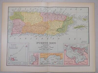
$6.00 Shipping Location: Los Angeles, United States Please see my other listing more Rare Maps from Puerto Rico. Please see photos for condition. Any questions please ask BEFORE bidding or making an offer. ... moreThank you!
Buy It Now
$3.50 Shipping Location: Mascotte, United States c1760 MAP OF THE LAKE OF MEXICO. MEASURES 9X7 INCHES. HAND LAID RAG PAPER. FINE CONDITION COMES WITH MY LIFETIME COA...PETERPAPERMAN...
Buy It Now
$13.74 Shipping Location: MANCHESTER, United Kingdom
Buy It Now
Free Shipping Location: Monroeville, United States Puerto Rico San Juan beautiful 1901 Cram antique folio detailed color map PORTO RICO(with insets of San Juan Harbor& Crab Island) Issued Chicago& ... moreNew York. 1901 by George Cram. Fine original antique offset color lithographed map. Made approximately 110 years ago. Printed in the early 20th century, on quality paper which retains its inherent structural flexibility and soundness. In near VG or better condition. Some very gentle toning to edges which is hardly offensive[note: we grade very conservatively and always seek to disclose any noteworthy flaws] The printed area remains visually pleasing. A nice impression of an interesting and amazingly detailed map. Sheet measures c. 22 1/4" W x 14 1/2" H. Printed area measures c. 20" W x 13 1/2" H. Folio. Original fold line as issued. 13537] Any defects along the sheet edges and in the margins may be seen in the photos. note: All old sheets of printed paper possibly have short edge splits. Each sheet has existed for a very long time and has probably been handled repeatedly in the course of it's existence. It has a history unique to it as an object. Most of the time any edge splits are short. Minor, insignificant and have been closed- either long ago or more recently with small pieces of archival tape. Most often these splits are trivial and easy to overlook visually. Basically, they would not significantly affect the piece adversely. The item is offered as seen. Please look carefully and make your decision knowing this antique image is nice. But it is not in perfect"like new" condition. However, with whatever flaws it possesses, it remains entirely worthy of ownership and inclusion in any related collection. We feel it will prove very pleasing to its new owner. We stand behind everything we sell. Everything we offer is guaranteed to be an authentic original antique item as described. We do not sell modern reproductions. Please visit our. We happily accept PayPal!
Buy It Now
$6.00 Shipping Location: Greenacres, United States It is an original, authentic antique map,not a reproduction or modern reprint. The map is titled "West India Islands," and it was engraved and printed ... moreby W. & A.K. Johnston, Edinburgh & London.
Buy It Now
$4.11 Shipping Location: Raleigh, United States
Buy It Now
$4.50 Shipping Location: Pinellas Park, United States
Buy It Now
$4.99 Shipping Location: Fairview, United States Atlas de toutes les parties connues du globe terrestre, published around 1780, afacsimile copy of the title page is included, which is undated. Bonne ... moreworked under Jacques Nicolas Bellin and succeeded him as the Royal Hydrographer of the King of France in 1773.
Buy It Now
$4.00 Shipping Location: Harborton, United States The map is in very good condition - note light creasing and there is another map on the reverse side.
Buy It Now
$4.00 Shipping Location: Harborton, United States Rand McNally atlas published in 1940.
$15.00 Shipping Location: Poland Date of issue: 1823. THIS IS AN ORIGINAL MAP, NOT A RECENT COPY OR REPRODUCTION. Origin of the map: Vosgien, "Dictionnaire Geographique …Les Parties Du ... moreMonde",publ. by Belon, Paris (France).
Buy It Now
$4.00 Shipping Location: Harborton, United States It is dated 1908 below the scale. It is in very good condition - note there is another map on the reverse side which is lightly visible on the top right ... morecorner. ANTIQUE MAP OF PUERTO RICO.
Buy It Now
$77.00 Shipping Location: Miami, United States
Buy It Now
$12.01 Shipping Location: Greenville, United States Made from heavy-duty leather, it showcases normal wear expected for its age, which only adds character and charm to its appeal. The zipper remains intact ... moreand operates smoothly as intended.
Buy It Now
$13.74 Shipping Location: MANCHESTER, United Kingdom This original antiquemap is from The Weekly Dispatch published in London in 1863. The mapmakers included Edward Weller, John Dower, R.R. Davies and J.W. ... moreLowry. This interesting map is an original antique which is over 160years old.
Buy It Now
$4.99 Shipping Location: Fairview, United States It is from Monin & Fremin's. Atlas Universel, published in Paris by Logerot, c. 1835, a facsimile copy of the title page is included. Condition: The map ... moreis in Very Good condition for its age, blank on the reverse, printed a bright page, with original hand outlining as issued, basically as seen in the pic.
Buy It Now
Free Shipping Location: Sayville, United States
Buy It Now
Free Shipping Location: Iowa City, United States Cuba, Jamaica, Haiti, Santo Domingo, Puerto Rico, The Bahamas, The Windward Islands. [and others]. This color map of theWest Indies is dated 1907 on the ... moreface. It was engraved and printed by theL.L.
Buy It Now
$4.95 Shipping Location: Willow Grove, United States This is an ORIGINAL WEST INDIES map titled West Indies which was taken from a 1945 atlas. There is text and a partial map on the reverse side of this ... moremap page.
Buy It Now
Free Shipping Location: Schertz, United States The map is not " new " or in " new " condition, it was printed in 1965. The map is not dated. Including Hundreds of RareCivil War.
Buy It Now
$6.90 Shipping Location: Audubon, United States It is an old, original map that was rescued from an unusable atlas. You will receive the exact antique map in the photos.
Buy It Now
$5.95 Shipping Condition: New Location: Las Vegas, United States Year: 1580. Each of our prints are custom reproductions printed on 68lb Heavyweight Enhanced Matte Art Paper. These Historic Art Prints are suitable for ... moreframing, mounting or direct display on any wall!
Buy It Now
$4.99 Shipping Location: Fairview, United States The Harmsworth Universal Atlas and Gazetteer, London, circa 1907. A copy of the title page is included for authenticity. It is not mounted nor matted, ... morebeing sold as a single sheet as seen in the main pic.
Free Shipping Location: Marana, United States This Map was removed from a 1911 Atlas and is in exceptional condition. Including Hundreds of RareCivil War. 110+ years of aging. Study the photos carefully, ... morethis is the actual map you. Only Authentic Originals.
Buy It Now
$6.95 Shipping Location: Atlanta, United States I will list if I have them. It DOES NOT have an institutional ink stamp. The map in the photo is the actual map you will receive.
Buy It Now
$4.75 Shipping Condition: Used Location: Sacramento, United States 1905 Standard Guide To Cuba Travel Handbook & Two Complete Maps - Great Piece! Two Excellent 1905 Maps of Havana + Travel Guide!!! I always combine shipping ... moreon multiple purchases, please visit my ebay store "wiztekworld" where you will find over 1000 ephemera items and collectibles. Thank you!.
Buy It Now
Free Shipping Location: Augusta, United States "An Authentic Original Map Not A Reproduction".
Buy It Now
$7.50 Shipping Location: West Palm Beach, United States John Tallis (1817-1876) was a British map publisher. FROM 1851 WRIGHTS UNIVERSAL PRONOUNCING DICTIONARY. ENGRAVINGS ARE EXCELLENT FOR HAND COLORING AND ... moreARE A PERFECT CANDIDATE FOR FRAMING OR MAKING ENLARGED PRINTS FOR UNIQUE DECOR.
Buy It Now
$6.70 Shipping Location: Mascotte, United States RARE ORIGINAL 9X7 INCHE MAP OF ACAPULCO MEXICO, EXECUTED ON HAND LAID RAG PAPER. CIRCA 1760. COMES WITH MY LIFETIME COA...PETERPAPERMAN...
Buy It Now
$12.00 Shipping Location: Fort Lauderdale, United States Engraved on chain-link paper with good margins. Excellent hand color, very good condition.
Buy It Now
$15.00 Shipping Location: Key Biscayne, United States José María de la Torre y de la Torre (1815-73) was a Cuban geographer, archaeologist, historian, and educator. De la Torre’s 1849. This is an original ... more( not a reproduction ) map of Havana of 1857 extracted from "Album Pintoresco de la Isla de Cuba' of Jose M. de la Torre y de la Torre based on his original work of 1849.
$7.00 Shipping Location: North Wales, United States 1849 ANTIQUE SMITH'S GEOGRAPHY ATLAS MAP OF THE WEST INDIES-HAND COLORED ORIGINAL ANTIQUE ATLAS MAP PLEASE SEE PHOTOS AS PART OF THE DESCRIPTION CONDITION: ... moreMAP IS IN GOOD CONDITION. SIZE: APPROXIMATELY 14" X 21" SHIPPING: U.S. FIRST CLASS RATE - $7.00 - ANY ITEM WHICH SELLS FOR OVER $100 WILL REQUIRE INSURANCE WE COMBINE SHIPPING FOR MULTIPLE WINS. THANK YOU FOR YOUR INTEREST IN OUR AUCTIONS!.
Buy It Now
$3.45 Shipping Location: Enterprise, United States CUBA & THE WEST INDIES - 1950s Map. Condition: Excellent - Very Good - Good - Fair - Poor (but of historical interest). I pride myself in providing optimal ... moreprotection. I will send a combined invoice reflecting your savings.
Buy It Now
$4.99 Shipping Location: Fairview, United States Atlas de toutes les parties connues du globe terrestre, published around 1780, afacsimile copy of the title page is included, which is undated. Bonne ... moreworked under Jacques Nicolas Bellin and succeeded him as the Royal Hydrographer of the King of France in 1773.
Buy It Now
Free Shipping Location: Monroeville, United States Date - 1880. inventory # j74123. Condition - Very Nice.
Buy It Now
$5.95 Shipping Condition: New Location: Las Vegas, United States Cuba and Bahamas. Year: 1650. “Vibrant and bright! Pic does not do it justice.looks amazing!”. Each of our prints are custom reproductions printed on ... more68lb Heavyweight Enhanced Matte Art Paper. These Historic Art Prints are suitable for framing, mounting or direct display on any wall!
Buy It Now
$6.00 Shipping Location: Los Angeles, United States Visible stain on left side of map, see photo. Map has several wrinkles throughout.
Buy It Now
$4.00 Shipping Location: Harborton, United States This is an original, not reproduction, Martinique map which was carefully removed from a George Cram atlas. ANTIQUE MAP OF MARTINIQUE.
Buy It Now
$5.95 Shipping Location: Bar Harbor, United States Mitchell Map. with quaint 19th century engravings. Original Antique Copper Plate. The map also shows the Falkland Islands which in 1982 was the site of ... morethe The Falklands War.
Buy It Now
$4.95 Shipping Location: Willow Grove, United States There is a map image and text on the reverse side of this map page.
Buy It Now
Free Shipping Location: Schertz, United States The map is not " new " or in " new " condition, it was printed in 1965. The map is not dated. Including Hundreds of RareCivil War.
Buy It Now
$9.95 Shipping Location: Kirksville, United States Dont see year on it, not recent, maybe around 2000.
Buy It Now
$6.90 Shipping Location: Audubon, United States It is an old, original map that was rescued from an unusable atlas. You will receive the exact antique map in the photos. Condition is very good, age ... moreconsidered. This map would look great displayed in any room.
Buy It Now
$5.95 Shipping Condition: New Location: Las Vegas, United States The Story Map of the West Indies. Year: 1936. Each of our prints are custom reproductions printed on 68lb Heavyweight Enhanced Matte Art Paper. These ... moreHistoric Art Prints are suitable for framing, mounting or direct display on any wall!
Buy It Now
$30.00 Shipping Location: Paris VI, France "ISLES LUCAYES". Antique copper engraved map of Lucayes islands, in Bahamas,by Alain Manesson Mallet (1630-1706), a French engineer at the court of Louis ... moreXIV. With a large part of Cuba. Edition : Paris, 1683, 17th Century.
Buy It Now
$4.99 Shipping Location: Fairview, United States Atlas de toutes les parties connues du globe terrestre, published around 1780, afacsimile copy of the title page is included, which is undated. Bonne ... moreworked under Jacques Nicolas Bellin and succeeded him as the Royal Hydrographer of the King of France in 1773.
Buy It Now
$6.90 Shipping Location: Audubon, United States It is an old, original map that was rescued from an unusable atlas. The entire miniature two page insert is 8" x 5.5". You will receive the exact antique ... moremap in the photos. Condition is very good, age considered.
Buy It Now
$10.20 Shipping Location: Tonawanda, United States 11 3/4" x 9 3/4", with a fold in the center (as issued). The bordered map area is about 10.5" x 8.25" with blank margins all the way around to allow convenient ... morematting. Very good used condition - see photos for condition.
$7.85 Shipping Location: Selbyville, United States Beautiful map of the Virgin and Leeward Islands in the Caribbean. This map was drawn in 199 by Allen R Boyd, Art by Paul M Breeden. The Virgin Islands ... moreshow St Thomas, St. John, St. Croix, Tortola, Virgin Gorda. Leeward islands shown are St. Martin, Sint Maarten, St. Barthelemy, St. Eustatius, Anguilla & Saba. Approximate measurements -19” x 25”. Caribbean Archives No. 3. New in tube, opened for photographs. From pet and smoke free home.
Buy It Now
$4.00 Shipping Location: Harborton, United States This is an original, not reproduction, antique map which was carefully removed from a Rand McNally atlas published in 1912. It is dated 1905 on the bottom ... moreedge. ANTIQUE COLLECTIBLE MAP OF CUBA. It is in very good condition - note smudge on the bottom left corner and there is another map on the reverse side.
Buy It Now
Free Shipping Location: Sayville, United States
Buy It Now
$4.99 Shipping Location: Fairview, United States A facsimile copy of the title page is included for authenticity. This map is in its original uncolored state from a very scarce atlas of the period. Condition: ... moreThe map is in Very Good condition, uncolored as issued with text on the reverse.
Buy It Now
$6.90 Shipping Location: Audubon, United States It is an old, original map that was rescued from an unusable atlas. You will receive the exact antique map in the photos.
Buy It Now
$12.60 Shipping Location: Bolingbrook, United States Sold rolled. Pin hole in each cornerPlease carefully view all pictures for full detail.
Buy It Now
$6.05 Shipping Location: Springfield, United States Most of my items are hand picked estate items in good to excellent condition. I describe the condition and add lots of photos which are an important part ... moreof the description. Items are not new, please read description and view all photos. All items are guaranteed as described / returns are accepted if item is misrepresented Please ask questions and request additional photos if necessary.If there is an issue or problem with your purchase PLEASE contact me prior to filing a claim or leaving feedback. I am very responsive. I am primary a seller and only an occasional buyer, so I will always respond positively to positive feedback. Thank you for looking. Many blessing
Buy It Now
$9.45 Shipping Location: Neosho, United States Very nice lithographic pictorial map of the British Virgin Islands. Signed by the artist, Roger Ellis. Any flaws noticed are indicated in photos.
Buy It Now
$9.99 Shipping Condition: Used Location: LONDON, United Kingdom 'West Indies'. Caption below picture:'West Indies '. PROVENANCE: "The Pocket Guide to The West Indies"; Edited by Algeron E. Aspinall; Published by Duckworth ... more& Co., London: New and revised [2nd] edition.
Buy It Now
Free Shipping Location: NORWICH, United Kingdom Detailed copper engraved map of Saint Lucia by Jacques Nicolas Bellin. This map was completed by Krevely 1775 for for the rare Dutch edition of "Histoire ... moreGenerale Des Voyages”. Copper engraving, 20.5 x 30 cm, original hand-colour, blank verso. Bellin (1703 - 1772), a French mapmaker, was named the hydrographer (chief cartographer) to the French Navy, and later, the Official Hydrographer to the French King. During his term as Official Hydrographer, the Depot was the single most active center for the production of sea charts and maps, including a large folio format sea-chart of France, the Neptune Francois. He also produced a number of sea-atlases of the world, e.g., the Atlas Maritime and the Hydrographie Francaise. These gained fame, distinction, and respect all over Europe and were republ.
Buy It Now
$6.00 Shipping Location: Los Angeles, United States Please see my other listing more Rare Maps from Puerto Rico. Please see photos for condition. Any questions please ask BEFORE bidding or making an offer. ... moreThank you!
|
|
|
|
1747 Ruyter Map of Florida, Mexico and the West Indies
1747 Ruyter Map of Florida. Mexico and the West Indies WE SELL ONLY ORIGINAL ANTIQUE MAPS- NOT REPRODUCTIONS Title: Kaarte Van de Golf van Mexico en het Zuyd-America waar in Porto-Bello en Panama aangewezen warden. Description: Engraved by Balthasar Ruyter. This is an extremely rare and highly unusual 1747 map of Mexico, the Caribbean, the West Indies and Florida. Covers from roughly Michoacán Mexico, west to Surinam, north as far as modern day Virginia and south as far as modern day Ecuador. The cartography exhibited here almost certainly references the important 1698 map of North America attributed to Friar Hennepin. The mouth and course of the Mississippi River are displaced far to the west of their actual location and are shown roughly where Galveston Harbor and Sabine Lake are now. Roughly where the actual mouth of the Mississippi ... moreis located, this map suggests a large bay which it calls“Baye de Spirito Sancto” Florida is misshapen with no trace of the Keys. Further south, the West Indies are fairly well mapped suggesting a relative accurate picture of the islands. Following the lead of Bleau and Hondius, the mainland of Mexico and Central America is wildly exaggerated along the horizontal. Yucatan is also extremely misshapen. In the north, the lake of Apalache, which first appeared in Jacque Le Moyne’s early 17th century map of Florida, is shown as the source of the St. John’s River. In today’s Texas, this map notes several mines and Indian villages including a stylized typee. Expanding upon Hennapin’s work, Ruyter includes a number of bays in southwestern Florida and adds the Negrillos Islands. The fascinating allegorical title cartouche in the upper right quadrant of this map deserves special attention. In a departure from the traditional iconography for America, Indians, sheep, bears, buffalo, etc. there appears a unicorn killing a ram, an eagle, a couple of jack rabbits, and a naval fleet. Ruyter was no doubt inspired by the 1671 work of Arnold Montanus, The New and Unknown World, in which eag
|
|
|
1780 Raynal and Bonne Map of Central America and Southern Mexico
1780 Raynal and Bonne Map of Central America and Southern Mexico WE SELL ONLY ORIGINAL ANTIQUE MAPS- NOT REPRODUCTIONS Title: Partie Meridonale De L'Ancien Mexique Ou De La Nouvelle Espagne Description: A fine example of Rigobert Bonne and Guillaume Raynal’s 1780 map of southern Mexico. Includes the area stretching from Panama in the south. To the Tropic of Cancer in the north. Includes the modern day nations of Mexico, Guatemala, Panama, Honduras, Belize, Costa Rica, Nicaragua, and El Salvador. Highly detailed, showing towns, rivers, some topographical features, important undersea features and political boundaries. Drawn by R. Bonne for G. Raynal’s Atlas de Toutes les Parties Connues du Globe Terrestre, Dressé pour l'Histoire Philosophique et Politique des Établissemens et du Commerce des Européens dans les Deux Indes. ... moreSize: Printed area measures 9 inches high by 13 inches wide. Condition: Very good. Original centerfold. Platemark visible. Blank on verso. Shipping: Items are shipped within three business days of receiving payment. We are happy to consolidate shipping where possible. The following shipping options are available: 1. USPS Domestic Express Mail(25 USD) USA Only. 2. USPS Priority Mail(12 USD) USA Only. 3. USPS International Express(35 to 55 USD) Recommended service for all international parcels. 4. USPS Priority Mail(25 USD) Available to only certain countries. Due to high instances of loss. This service is specifically NOT AVAILABLE to MAINLAND CHINA or INDIA. 5. Federal Express is available upon request. This is the only service option available to India and Africa. Price is quoted upon request following the auction. We can also use your Federal Express Account. Insurance: All shipments are insured privately against loss and damage. All of our shipments require a signature. If you have any questions please feel free to email us through eBay or contact us by telephone at 646-320-8650. Additional Services Conservation Framing Services: Geographicus recommends basic conservation
|
|
|
A VIEW GENERAL OF THE CITY DE HAVANA OF AMERIQUE. CUBA 1760
A VIEW GENERAL OF THE CITY DE HAVANA OF AMERIQUE. Highly attractive view of Havanna from the sea. Published in Paris. 1760. Measures 260 X 360 mm. A few marginal repairs. Otherwise in very good condition. Original hand colour with later additions. For further information please feel free to contact us. A guaranteed genuine antique map. SEE MORE GENUINE ANTIQUE MAPS AND PRINTS IN MY SHOP stores.ebay.co.uk/londonmapgallery
|
|
|
1889 ANTIQUE MAP OF CENTRAL AMERICA / COSTA RICA PANAMA NICARAGUA HONDURAS
1889 ANTIQUE MAP OF CENTRAL AMERICA/ COSTA RICA PANAMA NICARAGUA HONDURAS This original antique map gives you an opportunity to examine in exquisite detail a piece of history. If you are interested in the past of this country and its people or have a desire to study where your family may have come from. Then this map gives you a rare look as the area was about 120 years ago.Once matted and framed, this map would make a perfect gift for a family member or friend they'll cherish forever. Origin of the map: The Scribner-Black Atlas of the World" Published in New York by Charles Scribner's Sons(Edinburgh: Adam and Charles Black) Date of issue: 1889 Size: The sheet measures 17 1/2" x 12" 45 x 31 cm) S/H: The map will be shipped by Air Mail. The shipping charge is: USA- 7.50 USD. World- 8.50 USD, Canada- 8.50 USD. The price ... moreincludes the insurance and a strong, cardboard tube with plastic plugs. Attention! There is no additional shipping charge for multiple purchases! Pay me securely with any major credit card through PayPal! Payment methods: US/Canada Buyers: Paypal. International Buyers: Paypal. Click Here. Double your traffic. Get Vendio Gallery- Now FREE!
|
|
|
1780 Bonne Map VIRGIN ISLANDS - LESSER ANTILLES Decorative Arc of Islands!
Carte des Iles Antilles ou du Vent 32 cm x 20 cm copperplate enraving. 40 cm x 26 cm sheet size, modern hand colour, Paris, 1780 We are pleased to offer this scarce original map of the Virgin Islands. Lesser Antilles and part of South America compiled by the French cartographer Rigobert Bonne(1727-1795) Successor to Bellin as Chief Hydrogapher at the Dépôt de la Marine. Bonne is perhaps best known today for his early maps of the nascent United States which was still in the midst of the Revolutionary War when this map was published- indeed Bonne's maps of the period are among the first to name the"Ḗtats-Unis" as such. The map was compiled for the atlas volume Bonne produced to accompany the profoundly influential work Histoire philosophique et politique. Des établissements et du commerce des européens dans ... moreles deux Indes by Guillaume-Thomas Francois. Abbé Raynal(1713-1796) The map reflects the fact that the Caribbean was a principal focus of Abbé Raynal's work, which proved so controversial that it was banned and publicly burned owing to its anti-slavery sentiments and criticisms of the Catholic church expressed by the former Jesuit. Handsomely engraved and stretching from Puerto Rico to Trinidad and Tobago this example of the map features attractive hand colour work that will make for an elegant presentation if matted and framed. To get a sense of map detail consider that the top mileage scale seen below measures just 6 cm long actual size: Note pictorial topography: Condition- Please note carefully: Map is in excellent condition as can be ascertained from photos. Strong impression with prominent platemark on fine laid paper. Image area essentially pristine, centrefold as issued. welcome and we encourage you to visit our other on eBay. Note: Final auction price includes insured shipment within continental United States. All other customers to pay actual shipping costs via traceable means including full insurance. International buyers are wholly responsible for any a
|
|
|
1794 Wilkinson Map of the West Indies and Caribbean
1794 Wilkinson Map of the West Indies and Caribbean WE SELL ONLY ORIGINAL ANTIQUE MAPS- NOT REPRODUCTIONS Title: An Accurate Map of the West Indies. From the Latest Improvements. Description: A finely detailed first edition 1794 map of the West Indies and the Caribbean by Robert Wilkinson. Wilkinson’s map covers the West Indies. From the Mexican Coast to the Windward Islands, inclusive of, the Gulf of Mexico, the Caribbean, Central America, Florida, the Spanish Main, the Bahamas, and the Greater Antilles. Each region is color coded to identify its colonial overlord, with Spain in yellow, England in red, and the few French colonies in green. The tentative British claims in Belize and on the Mosquito Coast, where English buccaneers, pirates, and privateers set up makeshift unofficial colonies from which to raid Spanish treasure fleets, are ... morenoted. As this region was highly important to British maritime commercial and military interests, Wilkinson also identifies various shoals and other undersea dangers throughout. Engraved by Thomas Condar for the 1794 first edition of Robert Wilkinson’s General Atlas. Size: Printed area measures 8 inches high by 10 inches wide. Condition: Very good. Minor marginal soiling. Original platemark visible. Blank on verso. Shipping: Items are shipped within three business days of receiving payment. We are happy to consolidate shipping where possible. The following shipping options are available: 1. USPS Domestic Express Mail(25 USD) USA Only. 2. USPS Priority Mail(12 USD) USA Only. 3. USPS International Express(35 to 55 USD) Recommended service for all international parcels. 4. USPS Priority Mail(25 USD) Available to only certain countries. Due to high instances of loss. This service is specifically NOT AVAILABLE to MAINLAND CHINA or INDIA. 5. Federal Express is available upon request. This is the only service option available to India and Africa. Price is quoted upon request following the auction. We can also use your Federal Express Account. Insurance: All shipments are ins
|
|
|
1851 Coello Map of Puerto Rico (Porto Rico)
1851 Coello Map of Puerto Rico(Porto Rico) WE SELL ONLY ORIGINAL ANTIQUE MAPS- NOT REPRODUCTIONS Title: Isla de Puerto Rico por el Teniente Coronel Capitan de Ingenieros D. Francisco Coello. Las notas estadisticas e historicas han sido escritas por D. Pascual Madoz. Madrid 1851. Description: A fine example of Francisco Coello de Portugal y Quesada's massive map of Puerto Rico. Coello's map is the first scientifically produced Spanish map of Puerto Rico. The map is essentially ten individual maps on a signal sheet with extensive historical and statistical annotation. This sheet details Puerto Rico. San Juan, and eight other maps of ports, neighboring islands and important geographical features. Longitude is measured from Madrid. The 19th century was a period of great change for Puerto Rico and witnessed the abolishment of the slave ... moretrade, the 1851 founding of the Royal Academy of Belles Letters, the introduction of wired communication, and the rise of the Puerto Rican sovereignty movement. Engraved by D. Juan Noguera in Madrid as map no. 41 for Coello's unfinished opus Atlas de España y sus posesiones de Ultramar. Size: Printed area measures 31 inches high by 42 inches wide. Condition: Very good. Professionally flattened and backed on linen. Shipping: Items are shipped within three business days of receiving payment. We are happy to consolidate shipping where possible. The following shipping options are available: 1. USPS Domestic Express Mail(25 USD) USA Only. 2. USPS Priority Mail(12 USD) USA Only. 3. USPS International Express(35 to 55 USD) Recommended service for all international parcels. 4. USPS Priority Mail(25 USD) Available to only certain countries. Due to high instances of loss. This service is specifically NOT AVAILABLE to MAINLAND CHINA or INDIA. 5. Federal Express is available upon request. This is the only service option available to India and Africa. Price is quoted upon request following the auction. We can also use your Federal Express Account. Insurance: All shipments are insure
|
|
|
1788 Original Bonne Map: Les Isles de la Guadeloupe
1788 Original Bonne Map: Les Isles de la Guadeloupe Les Isles de la Guadeloupe. De Marie Galante, de la Desirade, et celles des Saintes: Colonie Francoise dans les Antilles, by Rigobert Bonne(1727-1795) 1788, hand-colored. Map is in very good condition, with slight edgewear, and folded as issued. Map(paper) measures 10" x 14¾" image measures 8¼" x 12¼" Please note that I am located in Canada. Winning bidder to pay by paypal. Alternate payment methods may also be accepted. Multiple winning bids will be combined to save on shipping. Please send me an e-mail if you have any questions. Good luck! Powered by
|
|
|
COLLECTION 6 ENGRAVING MAPS ANTILLES HAITI HISPANIOLA GUADELOUPE 1780 AD #A452S
1* Take advantage of purchasing rare prints and books as a crisis-resistant and stable value investment at reasonable prices! Nutzen Sie das Angebot von seltenen Graphiken und Büchern als krisenbeständige und stabile Wertanlage zu vernünftigen Preisen! Collection of 6 original copper engraving maps. Printed by Bellin, Prevost and Mallet about 1780 A.D. Description: We offer a collection of 6 copper engravings from various Cartographers about 1850 A.D. The maps shows the various Caribbean Antilles of Guadeloupe. Haiti, the Dominican Republic, St. Christopher, Martinique and a view of Santo Domingo from Mallet. The maps is a wonderful collection item! Size: can vary Leaf app. 36.5 x 25,0 cm Map app. 30.5 x 20,3 cm Condition in good condition strong print marginal brownish and stained marginal Water stains Please have a look at ... morethe pictures! If. Contrary to expectations, our information is not true, the buyer has of course the right to return the item step by step contra purchase price and cost reimbursement, subject to further legal regulations. For details see our general terms of business You may find further information concerning payment conditions and shipping at our me-page. Sammlung von 6 Originalen Kupferstich Karten. Gedruckt von Bellin, Prevost und Mallet um 1780 A.D. Beschreibung: Wir bieten Ihnen eine Sammlung von 6 Kupferstichen von verschiedenen Kartographen um 1780 A.D. an. Die Karten zeigen diverse Inseln von den Karibischen Antillen. Der Dominikanischen Republik, Guadeloupe, Martinique, St. Christopher und eine Ansicht von Santo Domingo von Mallet. Sehr dekoratives und wunderschönes Sammelobjekt! Maße: kann variieren Blatt ca. 36.5 x 25,0 cm Karte ca. 30.5 x 20,3 cm Zustand: im guten Zustand kräftiger Druck& schönes Kolorit wenig gebräunt und fleckig ein wenig Wasserfleckig Sehen Sie sich die Bilder an! Wir bieten Ihnen nur Originale an und keine Reproduktion! Sollten wider Erwarten unsere Angaben nicht zutreffend sein. Hat der Käufer selbstverst�
|
|
|
1879 Warren Map of Mexico, Central America and West Indies
1879 Warren Map of Mexico. Central America and West Indies WE SELL ONLY ORIGINAL ANTIQUE MAPS- NOT REPRODUCTIONS Title: Map of Mexico and Central America. Map of the West Indies. Description: This is an example of David M. Warren's 1879 map of Mexico. Central America and the West Indies. Divided into two parts, the upper map covers Mexico and Central America from Mexico to Costa Rica. The lower map details West Indies from the southern part of Florida to the northern part of South America and includes the Greater and Lesser Antilles as far east as Barbados. The map identifies the island of Guanahani or San Salvador in the Bahamas as the site where Columbus supposedly landed on October 12 of 1492. Throughout, the map identifies various cities, towns, rivers, islands, mountain passes and an assortment of additional topographical details. ... moreThe map is color coded according to regional and political boundaries with elevation rendered by hachure. Issued as page 59 in the 1879 edition of Warren's Common-School Geography. Size: Printed area measures 11.5 inches high by 9.5 inches wide. Condition: Very good. Even overall toning. Text on verso. Some foxing. Shipping: Items are shipped within three business days of receiving payment. We are happy to consolidate shipping where possible. The following shipping options are available: 1. USPS Domestic Express Mail(25 USD) USA Only. 2. USPS Priority Mail(12 USD) USA Only. 3. USPS International Express(35 to 55 USD) Recommended service for all international parcels. 4. USPS Priority Mail(25 USD) Available to only certain countries. Due to high instances of loss. This service is specifically NOT AVAILABLE to MAINLAND CHINA or INDIA. 5. Federal Express is available upon request. This is the only service option available to India and Africa. Price is quoted upon request following the auction. We can also use your Federal Express Account. Insurance: All shipments are insured privately against loss and damage. All of our shipments require a signature. If you have any questio
|
|
|
Central America Hawaii Islands Meyer c.1855 antique map very detailed old color
Central America Hawaii Islands Meyer c.1855 antique map very detailed old color MITTELAMERICA MIT DEN SPECIALKARTEN UBER(Central America- Hawaii- Pacific Island insets) Issued c.1850-60. Germany, for Meyer. Fine original antique engraved map. Made approximately 150 years ago. Printed in the mid-19th century in Germany, on quality paper which retains its inherent structural flexibility and soundness. With original hand color. In near VG or better condition[note: we grade very conservatively and always seek to disclose any noteworthy flaws] The printed area remains visually pleasing. A nice impression of an interesting image. Any minor defects along the sheet edges and in the margins may be seen in the photos. Sheet measures c. 12" W x 10" H. Engraved area measures c. 9 3/4" W x 7 1/4" H. 13061] note: All old sheets of printed ... morepaper possibly have short edge splits. Each sheet has existed for a very long time and has probably been handled repeatedly in the course of it's existence. It has a history unique to it as an object. Most of the time any edge splits are short. Minor, insignificant and have been closed- either long ago or more recently with small pieces of archival tape. Most often these splits are trivial and easy to overlook visually. Basically, they would not significantly affect the piece adversely. The item is offered as seen. Please look carefully and make your decision knowing this antique image is nice. But it is not in perfect"like new" condition. However, with whatever flaws it possesses, it remains entirely worthy of ownership and inclusion in any related collection. We feel it will prove very pleasing to its new owner. We stand behind everything we sell. Everything we offer is guaranteed to be an authentic original antique item as described. We do not sell modern reproductions. Please visit our eBay Store. We happily accept PayPal! WE OFFER FLAT RATE SHIPPING WORLD WIDE! Please request
|
|
|
Isthmus of Panama c. 1851 decorative antique Tallis map
Isthmus of Panama c. 1851 decorative antique Tallis map Isthmus of Panama Issued c.1851 by the London Printing and Publishing Company. London Map. Drawn and Engraved by J. Rapkin Illustration by H. Warren Fine original antique map. Printed in the mid-19th century, on quality paper which retains its inherent structural flexibility and soundness. There are different versions of this map. This one naming Veragua but not showing or naming Azuero below it. With original hand color. A lovely decorative map with fine vignette views and elaborate engraved border. In Good condition. Light minor age wear, blank margins trimmed close to engraved border, small edge splits mended on back with archival tape, a 1" tear at left side which extends a bit into the engraved border, overall very presentable and attractive[note: we grade very conservatively ... moreand always seek to disclose any noteworthy flaws] The printed area remains visually pleasing. A nice impression of an interesting antique map which will look nice when displayed. Original centerfold as issued. Sheet measures c. 14 1/2" W x 10 1/8" H. Printed area measures c. 13 3/4" W x 9 3/4" H. 21250] Any defects along the sheet edges and in the margins may be seen in the photos. note: All old sheets of printed paper possibly have short edge splits. Each sheet has existed for a very long time and has probably been handled repeatedly in the course of it's existence. It has a history unique to it as an object. Most of the time any edge splits are short. Minor, insignificant and have been closed- either long ago or more recently with small pieces of archival tape. Most often these splits are trivial and easy to overlook visually. Basically, they would not significantly affect the piece adversely. The item is offered as seen. Please look carefully and make your decision knowing this antique image is nice. But it is not in perfect"like new" condition. However, with whatever flaws it possesses, it remains entirely worthy of ownership and inclusion
|
|
|
Isthmus of Panama Port at Chagre c. 1851 decorative antique Tallis map
Isthmus of Panama Port at Chagre c. 1851 decorative antique Tallis map Isthmus of Panama Issued c.1851 by The London Printing and Publishing Company. London Map. Drawn and Engraved by J. Rapkin Illustration by H. Warren Fine original antique map. Printed in the mid-19th century, on quality paper which retains its inherent structural flexibility and soundness. There are different versions of this map. This one naming Veragua but not showing or naming Azuero below it. With original hand color. A lovely decorative map with fine vignette views and elaborate engraved border. In Good+ to near VG condition. Light minor age wear, blank margins trimmed close to engraved border, small edge splits mended on back with archival tape, overall very presentable and attractive[note: we grade very conservatively and always seek to disclose any noteworthy flaws] ... moreThe printed area remains visually pleasing. A nice impression of an interesting antique map which will look nice when displayed. Original centerfold as issued. Sheet measures c. 14 1/2" W x 10 1/8" H. Printed area measures c. 13 3/4" W x 9 3/4" H. 21251] Any defects along the sheet edges and in the margins may be seen in the photos. note: All old sheets of printed paper possibly have short edge splits. Each sheet has existed for a very long time and has probably been handled repeatedly in the course of it's existence. It has a history unique to it as an object. Most of the time any edge splits are short. Minor, insignificant and have been closed- either long ago or more recently with small pieces of archival tape. Most often these splits are trivial and easy to overlook visually. Basically, they would not significantly affect the piece adversely. The item is offered as seen. Please look carefully and make your decision knowing this antique image is nice. But it is not in perfect"like new" condition. However, with whatever flaws it possesses, it remains entirely worthy of ownership and inclusion in any related collection. We feel it will pro
|
|
|
Martinique Copperplate 1822 Antique Map 36400
Title: Charte von der Westindischen Insel Martinique, Author: Pluth, Year: 1822, Edition: 0.00, Size: 18.8x16cm, Condition: Very Good, Publication Loc: Prague, Binding: none, Pages: 1, Our Item# 36400, Map of the Island of Martinique. By one Fr. Pluth, from Prague in 1822. Attractive detail with early attempt at topography and mountains/volcanoes. Slightly soiled margins. Folded as made for inclusion in the atlas. Heavy, hand-laid paper, blank verso. Mounted to a temporary mat. Will be removed and rolled for shipping. Measurements are of the frame line; page size is larger. An absolutely guaranteed original, copperplate antique map going on 200 years old. Contact: Guarantee: Payment: According to eBay rules. We accept PayPal for payment. 6.7% sales tax will be added for all Colorado deliveries. Shipping: PLEASE NOTE: We lose money on shipping- ... morelook at the postage when you get the package. Factor in the free private insurance(instead of charging you the high postal service ins rates) And see how much you paid. Please keep this in mind when giving stars for shipping costs. International Shipping: For shipment out of the USA. Items in value over $100 are shipped registered insured, which is why the high shipping fee. Even so, we lose money on shipping- look at the postage when you get the package, factor in the free private insurance(instead of charging you the high postal service ins rates) And see how much you paid. Please keep this in mind when giving stars for shipping costs. International Buyers– Please Note: Import duties. Taxes and charges are not included in the item price or shipping charges. These charges are the buyer's responsibility. Please check with your country's customs office to determine what these additional costs will be prior to bidding/buying. We cannot mark items as'gift' We are required to put the actual value of the items won on each package. The delays and/or duties caused by this are completely out of our control and sphere of responsibility. Shipping
|
|
|
Mexico Central America West Indies 1874 Armstrong antique w/ Mt. Heights map
Mexico Central America West Indies 1874 Armstrong antique w/ Mt. Heights map MEXICO CENTRAL AMERICA. WEST INDIES. Issued New York. 1874 by Armstrong. Very uncommon mid 19th century color lithographed map. Nicely detailed. With comparative topographical profiles along the bottom detailing the region's mountains, as well as maps of Haiti and the Dominican Republic and part of Mexico at the bottom. Map colored to emphasize land mass topography. Beautifully printed. In good+. Mostly clean condition. Map uniformly toned, with some gentle and hardly noticeable scattered spotting. Some corners bent. None of which are visually offensive. Otherwise map remains clean and well-preserved overall. A fine map for display. Sheet measures c. 12" W x 9 1/4" H. Printed area measures c. 10 3/4" W x 8 1/4" H. 7501] Any defects along the ... moresheet edges and in the margins may be seen in the photos. note: All old sheets of printed paper possibly have short edge splits. Each sheet has existed for a very long time and has probably been handled repeatedly in the course of it's existence. It has a history unique to it as an object. Most of the time any edge splits are short. Minor, insignificant and have been closed- either long ago or more recently with small pieces of archival tape. Most often these splits are trivial and easy to overlook visually. Basically, they would not significantly affect the piece adversely. The item is offered as seen. Please look carefully and make your decision knowing this antique image is nice. But it is not in perfect"like new" condition. However, with whatever flaws it possesses, it remains entirely worthy of ownership and inclusion in any related collection. We feel it will prove very pleasing to its new owner. We stand behind everything we sell. Everything we offer is guaranteed to be an authentic original antique item as described. We do not sell modern reproductions. Please visit our. We happily accept PayPal!
|
|
|
1780 BONNE Map SOUTHERN MEXICO - YUCATAN - CENTRAL AMERICA Decorative & Detailed
Partie Méridionale de L'Ancien Mexique ou de La Nouvelle Espagne 32 cm x 22 cm copperplate enraving. 40 cm x 26 cm sheet size, modern hand colour, Paris, 1780 We are pleased to offer this scarce original map of southern Mexico and Central America compiled by the French cartographer Rigobert Bonne(1727-1795) Successor to Bellin as Chief Hydrogapher at the Dépôt de la Marine. Bonne is perhaps best known today for his early maps of the nascent United States which was still in the midst of the Revolutionary War when this map was published- indeed Bonne's maps of the period are among the first to name the"Ḗtats-Unis" as such. The map was compiled for the atlas volume Bonne produced to accompany the profoundly influential work Histoire philosophique et politique. Des établissements et du commerce des européens ... moredans les deux Indes by Guillaume-Thomas Francois. Abbé Raynal(1713-1796) The handsomely engraved map is notable for its careful depiction of reefs and atolls in the Gulfs of Mexico and Honduras and this example features beautiful hand colour work that will make for a most elegant presentation if matted and framed. To get a sense of map detail consider that Cozumel of the coast of the Yucatan peninsula as seen below measures just 8 mm long actual size: Note pictorial topography. Attractive blue wash colour for littoral waters: Condition- Please note carefully: Map is in excellent condition as can be ascertained from photos. Strong impression with prominent platemark on fine laid paper. Image area essentially pristine, centrefold as issued, a little trivial soiling lower right margin. welcome and we encourage you to visit our other on eBay. Note: Final auction price includes insured shipment within continental United States. All other customers to pay actual shipping costs via traceable means including full insurance. International buyers are wholly responsible for any applicable customs fees. Duties or taxes upon receipt; these charges are NOT included in shipping ch
|
|
|
FOUNDATION MAP OF CENTRAL AMERICA 1630 DE LAET, CARIBBEAN, FLORIDA, MEXICO
Nova Hispania. Nova Galicia, Guatimala General description Foundation map of Central America Foundation map of Central America and the Caribbean. Made by Hessel Gerritsz. One of the most important Dutch cartographers of the 17th century and published in his Nieuwe Wereldt ofte Beschrijvinghe van West-Indien. Most of his work exists only in manuscript and these maps, published by De Laet, are the only Gerritsz maps available to the collector today. The map includes Mexico and Costa Rica with considerable detail. Map maker/Cartographer: Hessel Gerritsz/ Joannes de Laet Year printed: 1630 Place printed: Amsterdam Verso: Blank Condition Excellent condition. Fresh paper, original margins, flawless copy Size 356 mm x 280 mm We do not sell reproductions. All items guaranteed genuine and from the time and authors called for. Feel free to contact ... moreus for any questions! We combine shippings! Take a look at our other auctions for more prints and maps!
|
|
|
West Indies Caribbean Cuba Haiti 1850 Sidney Hall antique map w/ nice hand color
West Indies Caribbean Cuba Haiti 1850 Sidney Hall antique map w/ nice hand color WEST INDIES w/ inset of Jamaica Issued Edinburgh. 1850 by A& C Black. Engraved by Sidney Hall Fine original antique map. Made approximately 160 years ago. Printed in the mid-19th century, on paper which is now evenly age toned as typical, and retains its inherent structural flexibility and soundness. With attractive original full hand color. We note a large area called"British Honduras" just below Yucatan. In near VG or better condition. Margins toned, small edge stain in corner[note: we grade very conservatively and always seek to disclose any noteworthy flaws] The printed area remains visually pleasing. A nice impression of an interesting map, the hand color particularly pleasing with its unique age mellowed appearance. Sheet measures c. 16 1/2" ... moreW x 11 1/2" H. Printed area measures c. 14 3/4" W x 10" H. Folio sheet. 15031] Any defects along the sheet edges and in the margins may be seen in the photos. note: All old sheets of printed paper possibly have short edge splits. Each sheet has existed for a very long time and has probably been handled repeatedly in the course of it's existence. It has a history unique to it as an object. Most of the time any edge splits are short. Minor, insignificant and have been closed- either long ago or more recently with small pieces of archival tape. Most often these splits are trivial and easy to overlook visually. Basically, they would not significantly affect the piece adversely. The item is offered as seen. Please look carefully and make your decision knowing this antique image is nice. But it is not in perfect"like new" condition. However, with whatever flaws it possesses, it remains entirely worthy of ownership and inclusion in any related collection. We feel it will prove very pleasing to its new owner. We stand behind everything we sell. Everything we offer is guaranteed to be an authentic original antique item as described. We do not sell mode
|
|
|
Havana Cuba May 1762 Jolly UNIV-107 Scarce folio
Havana Cuba May 1762 Jolly UNIV-107 Scarce folio An exact Plan of the City. Fortifications& Harbour of Havana in the Island of Cuba: From an Original Drawing taken on the Spot. Issued May 1762 London by J. Hinton for the Universal Magazine. Uncommon& very detailed mid-18th century engraved plan of Havana. Cuba. With a large decorative title cartouche at upper left, a central plan with numerous harbor depth soundings(including a chain across the harbor entrance) and an inset map of Cuba island at bottom left. North is towards upper left. Sugar plantations are seen at right. Also includes the original three text leaves from the May 1762 magazine which accompanied the map. Tipped onto the backing sheet at left, laid over the top of the map(but which fold back, as seen in photos) These text leaves contain the specific references which ... moreare found as letters on the map. In Good+ to near VG. Mostly clean condition. Blank margins have been trimmed all around to just outside the neatlines, short split along one of the bottom fold-lines, map& magazine leaves have been mounted at four corners to larger backing sheet. Otherwise remaining clean and quite well-preserved overall. Map sheet measures c. 13 9/16" W x 10 5/16" H. Jolly. Maps in British Periodicals. UNIV-107. Sellers& Van Ee. Maps of North America. 1814[noting the example in the Library of Congress is imperfect, missing the lower right corner and with a deteriorated upper border! Z9629. Please look carefully and make your decision knowing this antique image is nice. But it is not in perfect"like new" condition. However, with whatever flaws it possesses, it remains entirely worthy of ownership and inclusion in any related collection. We feel it will prove very pleasing to its new owner. Everything we offer is guaranteed to be an authentic original antique item as described. We do not handle or deal in modern reproductions and stand behind everything we sell. Please visit our. SHIPPING& TE
|
|
|
Original 1764 Bellin Map SAINT KITTS Basseterre Charlestown West Indies Island
Original 1764 Bellin Map SAINT KITTS Basseterre Charlestown West Indies Island Handsome original copperplate engraved antique map of the island of St. Kitts. Printed more than 248 years ago. This map of St. Kitts(also known more formally as Saint Christopher) One of the Leeward Islands in the Lesser Antilles, was drawn by Jacques Nicolas Bellin and published in his Petit Atlas Maritime. Paris, 1764. The image area measures 20.2 x 34 cm[8" x 13-1/2" And the map is titled Carte de l'Isle de St. Christophe. The scans below give a closer look: Topography is shown in relief. And the map locates towns, forts, parishes, and shoreline features, including numerous anchorages. Among the specific named places and features are the town and fort of Basse-Terre, Pointe de Sable, Pointe Ragged, Pointe de Par, Pointe de St. Croix, La Grande ... morePointe, and Charlestown. Longitude is measured from Paris. There is a compass rose with fleur de lis crossing the chart and a decorative title cartouche at the upper right. An ornamental mileage scale is drawn in lower left. Jacques Nicolas Bellin was the first Ingénieur de la Marine of the Depot des cartes et plans de la Marine(the French Hydrographical Office) and was named Official Hydrographer of the French King. This map is a fine example of his work. And it would make a beautiful display in your den or office. It would also make a perfect gift, and we will include our helpful tips on framing with your purchase. Condition: This map is in very good condition. With a vertical fold, as issued, and no rips or tears. There is some light spotting in the margins and faint offsetting. It is a strong impression and is uncolored. As issued. This is an original. Authentic antique map, not a reproduction or modern reprint. And it is fully guaranteed to be genuine. We are pleased to offer it with our unconditional. Money-back guarantee. SHIPPING: We gladly ship anywhere in the World. And we use sturdy, professional packing materials to assure safe delivery. The shipping charges are
|
|
|
Beautiful 1877 Antique Map: the West Indies by Johnston
A FINE ANTIQUE HAND-COLORED MAP by ALEXANDER KEITH JOHNSTON WEST INDIA ISLANDS Provenance The Cabinet Atlas of the Actual Geography of the World, with a Complete Index. Published W. A. K. Johnston: Edinburgh& London. 1877. Cartographer Constructed by A. Keith Johnston. L.L.D. F.R.S.E. F.R.G.S. Geographer to the Queen. Engraved& printed by W. A. K. Johnston, Edinburgh& London. Size/ Format Page area: 12.2" x 9.5" 31 cm x 24.5 cm) Map area 10" x 7.75" 25.5 cm x 19.5 cm) Hand-colored outlining. Printed on one side only. No folds. Condition The condition of these maps is very good to fine. Normal age-toning. Margins are clean with the occassional thumb-marks. Printed on thicker medium-weight paper(close to carton) The image below shows the actual map. Please note that the straight lines on one side of the map(in ... morevarious very light colours: purple. Red, green, yellow, etc. are due to my faulty scanner- they don't exist in the actual maps. Remarks These maps are very scarce. I was only able to find. Or find reference to, one or two other copies of the atlas from which they come available anywhere. A copy of the title page will be included with each map purchased. Click the image above for more maps from this atlas
|
|
|
Fine Antique 1879 JOHNSTON School Atlas Map of Central America & West Indies
A Fine Antique Map of CENTRAL AMERICA and The WEST INDIA ISLANDS Provenance A School Atlas Of General And Descriptive Geography. Exhibiting The Actual And Comparative Extent Of All The Countries In The World, With Their Present Political Divisions, Founded On The Most Recent Discoveries And Rectifications. Author/Cartographer Alexander Keith Johnston. L.L. D. F.R.S.E. F.R.G.S. Publisher W. A. K. Johnston. Edinburgh and London. 1879. Size/ Format Double-page: 13.75" x 10.75" 35 cm x 27 cm) Framed map: 12" x 9.25" 30.5 cm x 23.5 cm) Printed on one side only with one fold in the middle. On heavy, high quality paper(almost card) Condition Very Good. Very minor soiling or foxing whatsoever. The paper is bright. With almost no age-toning. The maps of this atlas are colorful and detailed(see scanned images below) Small(less than ... more0.5" close tear on ends of the centerfold on some of the maps have been professionally repaired and no longer noticeable. ALL OUR ANTIQUE PRINTS AND MAPS ARE ORIGINALS WE DO NOT SELL REPRODUCTIONS OF ANY KIND
|
|
|
1887 Hydrographic & Topographic Chart GUADELOUPE Surveyed By Ploix & Caspari
Guadeloupe and Adjacent Islands 95 cm x 77 cm steelplate engraving. U.S. Navy Hydrographic Office, Washington D.C. 1881, revised 1887 We are pleased to offer this massive(95 cm x 77 cm) hydrographic and topographic chart of Guadeloupe and surrounding islands employing simply extraordinary hachure engraving work for the island's volcanic topography. As the chart's title indicates. The chart is based on French Naval surveys in 1867 and 1869 and in a charming touch features all lighthouses meticulously indicated with tiny hand colour yellow and red. The 1867 expedition was under the command of Charles-Martin Ploix(1825-1895) who as Ingénieur-Hydrographe de Première Classe made groundbreaking surveys and charts all around the world during his career. The 1869 survey was undertaken by the Ingénieur-Hydrographe et Chef de ... morela Marine(1840-1918) who was also a noted astronomer. Eventually holding office as the President of the Societé Astronomique de France. Their work was so accurate that no further surveys of any consequence were deemed necessary until after the Second World War. The chart, while a marvel of hydrographic and topographic mapping science, is also a map of uncommon beauty that would make a most impressive(albeit rather large! presentation if matted and framed. To get a sense of the extroardinary topographic detail consider that the distance from the volcanic vent at the peak of to the lighthouse at Basse Terre measures just 6 cm actual size: Note improbable road network crossing rugged terrain: Less rugged terrain on Grand-Terre than on Basse-Terre. But still meticulously depicted through hachure work- note extensive depth soundings, depiction of shoals etc. Marie-Galante with lighthouse at Grand-Bourg glowing brightly: Condition- Please note carefully: Image area of chart is in very good condition with some scattered agetoning and trivial soiling but overall unusually well preserved. Upper left map border is severely creased and frayed but not affecting image area; upper right
|
|
|
Central America Map: Authentic 1908 (Dated) Cities, Topog, Panama Canal Route
1908 Engraved Color Map of Central America This is a 100+ Year-old Map. NOT a Reproduction Satisfaction Guaranteed Bordered map area is about 12.5" by 9.25" with margins sufficient to allow matting or framing. Pictured below without full margins. Printed on medium weight paper with NO Fold. Condition: is Very Good. As shown. This color map of Central America is dated 1908 on the face. The map came from a Rand McNally atlas published in 1909. The Panama Railroad and the(still under construction) Panama Canal are shown. Satisfaction Guaranteed or RETURN for any reason within 10 days for prompt refund. Powered by The free listing tool. List your items fast and easy and manage your active items.
|
|
|
GUATEMALA authentic Antique Map HONDURAS NICARAGUA genuine 118 years old - 1895
This scan is enlarged to show representative detail. CENTRAL AMERICA Authentic 118-Year-Old Antique Map FREE SHIPPING ANYWHERE IN THE USA! Printed in 1895. This is a beautiful, 118-year-old color map of Central America including British Honduras(modern Belize) Gautemala, San Salvador, Honduras, Nicaragua, Costa Rica, Veragua and Panama(part of Colombia) It measures about 11 by 14 inches(about 28 by 36 cm. and is in Fine condition. It contains a wealth of detail including topographical features, latitude and longitude, cities and villages, routes of old railways, and more. This is a guaranteed genuine antique map! Ideal for genealogy or other historical research. This map was printed on a single sheet of stock and bound whole in an antique book. There are no folds, creases, stains or marks, and the paper is clean and not brittle. A similar ... moremap of Mexico is printed on the reverse. Highly suitable for framing(see sample presentation below) this map would look great in your office, den or study. It is similar to many of the maps sold in expensive mail-order catalogues and department stores, with one important difference: this is an actual antique. NOT modern reproduction. An excellent investment. This map is certain to appreciate in value over time. Please ask all questions before making your purchase. SAMPLE DISPLAY IDEA SAMPLE DISPLAY IDEA FREE SHIPPING anywhere in the USA by USPS First Class Mail. Priority and Express services also available. Shipped rolled in a sturdy tube. I ship worldwide! cua95a
|
|
|
West Indies India Islands: TWO Authentic 1889 Maps showing Topography & Currents
Authentic 1889 Color Maps Lot of Two Maps of the West Indies Satisfaction Guaranteed Please scroll down to see individual scans of the two maps This lot of two color maps of the West Indies was included in Encylopaedia(Encyclopedia) Britannica's Ninth Edition as published in 1889 by the New York publisher Charles Scribner's Sons. These are genuine 1889 maps-NOT reproductions. The maps are printed on medium weight paper-blank on the reverse. Each sheet size is about 10.75" x 8" And the scans are only slightly cropped. Condition is very good-as shown. West Indies Political Map: Includes Cuba. Jamaica, Haiti/San Domingo; Porto Rico; Virgin Islands Bahama Islands and more Chart of Sea Depths and Land Elevations: Maps are identified on the face as being from Britannica's Ninth Edition which was published by a number of publishers ... moreover a period of years-primarily between 1885 and 1889. Bid with confidence- Returnable for any reason within 10 days for prompt refund. Powered by The free listing tool. List your items fast and easy and manage your active items.
|
|
|
Bermuda Islands Map: Authentic 1899 showing Cities; Ports Topography; +
1899 Map The Bermuda Islands(This map is 110+ Years Old- NOT A reproduction) Printed on a single sheet without a fold in the center. Bordered area is about 13.25" x 10" with margins sufficient to allow matting or framing. A laser-printed facsimile of the copyright information as it appears in the atlas from which this original map was removed will be included. On a peel-off. Self-adhesive sheet. Purchasers who frame their maps frequently affix that copyright statement to the back of the frame. This color map of Bermuda was taken from a Cram's Atlas published in Chicago by George Cram(scan from the atlas copyright page shown at the top of this listing) Close-up below to show detail. The map is printed on medium weight paper. And is in very good condition- as shown. Bid with confidence- Returnable for any reason within 10 days ... morefor prompt refund. Powered by The free listing tool. List your items fast and easy and manage your active items.
|
|
|
CUBA JAMAICA 1683 original antique map ( MALLET )
Excellent quality ORIGINAL antique engraved map TITLE: De CVBA Et De IAMAICA( CUBA- JAMAICA) Publication& Date: issued in Paris 1683 by A.M.Mallet Description: Very interesting. Detailed and decorative item. Scroll title, galleons to birds-eye view map. Scarce Condition& Size: Clean and good condition- printed area 4"x 6" 10x15cm) plus good margins. Black/white SCARCE ITEM Postage: UK- 2.50- Europe- £4.00- Rest of World and USA- £7.00(Can combine to save on postage) Visit our many other interesting listings of maps& prints on our Site(rediiwi) and in our E-BAY STORE Payment: Use Paypal or ask for details Thanks for looking
|
|
|
1780 Bonne Map VIRGIN ISLANDS - LESSER ANTILLES 10 Island Charts on 1 Plate
Supplément Pour Les Isles Antilles Extrait des Cartes Angloises 32 cm x 20 cm copperplate enraving. 40 cm x 26 cm sheet size, modern hand colour, Paris, 1780 We are pleased to offer this scarce original map of the Virgin Islands and Lesser Antilles(the latter presented in nine individual charts) compiled by the French cartographer Rigobert Bonne(1727-1795) Successor to Bellin as Chief Hydrogapher at the Dépôt de la Marine. Bonne is perhaps best known today for his early maps of the nascent United States which was still in the midst of the Revolutionary War when this map was published- indeed Bonne's maps of the period are among the first to name the"Ḗtats-Unis" as such. The map was compiled for the atlas volume Bonne produced to accompany the profoundly influential work Histoire philosophique et politique. Des ... moreétablissements et du commerce des européens dans les deux Indes by Guillaume-Thomas Francois. Abbé Raynal(1713-1796) The map reflects the fact that the Caribbean was a principal focus of Abbé Raynal's work, which proved so controversial that it was banned and publicly burned owing to its anti-slavery sentiments and criticisms of the Catholic church expressed by the former Jesuit. Handsomely engraved with hachure topography on the individual island maps, this example features attractive hand colour work that will make for an elegant presentation if matted and framed. To get a sense of map detail consider that the top mileage scale seen below measures just 8 cm long actual size: Nine separate charts for Lesser Antilles: Condition- Please note carefully: Map is in very good condition as can be ascertained from photos. Strong impression with prominent platemark on fine laid paper. Image area essentially pristine, centrefold as issued. Map exhibits some creasing in centrefold area with a diagonal crease in left margin crossing briefly into image area before dissipating, two tiny conjugate wormholes left margin. welcome and we encourage you to visit our other o
|
|
|
1774 N. Bellin's " Carte de I'isle de la Guadeloupe" (Original Antique Map)
SEE ALL MY ITEMS: EBAY ADVANCE SEARCH. SELLER, mapseller01 Terms: Domestic and Overseas shipping as per prices listed on bid details. Please note: No refunds on overseas items sent without tracking. We ship within 48 hours of receipt of funds. Any questions. Please email or you can call: The Map Seller 1-858-571-2031. We only sell maps. Prints and books relating to cartography. We answer all questions in a timely manner. No reproductions unless clearly stated Additonal cartographic materials available at PS Maps.
|
|
|
Stieler's Atlas1864 map central america cuba haiti bahamas carribbean jamaica
West-Indien und Central-Amerika Engraving on creme paper. Engraved by Hase. Berge v. Stichart. Published 1864 in Stieler's Hand-Atlas(No 48) Well inked impression. Slight soiling and some foxing. Upper right corner with dampstain. Pale foxing. Extremities with discolouration. A few small rips and tears.
|
|
|
1803 Cary Large Antique Map of United States GOM Texas
Helpful Links: Company Details- About ME View seller's other items Cartographer's Profile Ask Seller a q uestion Return Policy We have over 2.000 items for sale on our Ebay stores site. Please click here to enter the stores and use the search engine to the left to search specifically for maps. Prints, Atlases on the Classical Images Stores. Thank you A New Map of The West India Isles.1803 click image to enlarge This large beautifully hand coloured original antique map of the United States. Texas, the Gulf of Mexico, Caribbean, Central America and northern South America was engraved by John Cary in 1803- the date is engraved in the title cartouche- and was published in 1808 for Cary's New Universal Atlas. Ref Tooley M&B) Please note all items auctioned are genuine. We do not sell reproductions. A Certificate of Authenticity(COA) ... morecan be issued on request. Condition Report General Description: Paper thickness and quality: Heavy and stable Paper color: off white Age of map color: Original Colors used: Green. Yellow, pink General color appearance: Authentic Paper size: 24 1/2in x 21 1/2in(620mm x 550mm) Plate size: 21 1/2in x 19 1/2in(535mm x 495mm) Margins: Min 1/2in(12mm) Imperfections: Margins: None Plate area: Two dark ink spots on the L&R sides of image Verso: None Overall Quality(in Bold) Perfect/Fine/ Very Good/Good/Fair/Poor John Cary 1754-1835 Many regard John Cary as one of the finest English cartographers of his time. His maps are not decorative in the 17 th century sense but he came to on the scene at a time when the large-scale English county maps had recently become available. His fine craftsmanship and ability as an engraver enabled him to produce not only fine English county maps but also world atlases. Road maps, town and canal plans sea charts and terrestrial and celestial globes Payment Methods Visa MasterCard Bankcard* PayPal Direct Bank Transfers& AUS$ Bank Drafts Please contact me to discuss other forms of payment Please also contact me before the end of the
|
|
|
1886 Cuba & Bahama Islands Original Color Atlas Map^ 126 Years-old!!!
1886 Cuba& Bahama Island Original Color Map Gorgeous. Original 1886 Cuba and Bahama Islands Color map. Also shows Jamaica and Haiti. This is an ORIGINAL.NOT A REPRINT. 126 + year-old undated atlas map.The total size of the entire map measures 13 1/2" x 10 1/2" with the borders. The map shows towns and cities. A few railroads or roads or both.It is not clear) rivers, mountains and other Geographic features, etc. Great, Historic Item. NOTE CONDITION: The map has some lite border and corner wear. Otherwise, it is in Nice Condition and will look wonderful matted and framed(These old maps make great gifts) Please see the attached photo to view the Map. And a couple of closeup sections of the map. Please note that the map is too large for my scanner.There is a border all the way around the map.Also. The map is much clearer than the ... morescan illustrates. The printing is small but very clear and readable* Purchase this 126 year-old Cuba map for only $15.95. U.S. Buyer pays $3.00 for shipping. $4.00 shipping to Canada; $6.00 to Europe. 1-4 maps can be combined to save on shipping. Maps are shipped in sturdy mailing tubes. Please Note: This is an original 1886 undated atlas map. For the winning bidder. I will enclose a copy of the dated 1886 copyright page to keep with their map. If you have any questions about this map or any of my items. Please email me before bidding. Thanks! 032912 Cuba86.3(p) Please visit my eBay store to view my West Indies. Central America, Mexico, Cuba, Jamaica, Bahama, Bermuda and other vintage maps. Thanks for looking! ALL INTERNATIONAL BUYERS PLEASE DON'T BID UNTIL YOU READ THE FOLLOWING: Please be aware that some packages going into Canada. The UK and France are taking a very long time for delivery.2-or More weeks in some cases depending on customs. Although I mail them as quickly as I can.I have no control over how long it takes for them to be delivered after I mail them.Also, These old maps are shipped in sturdy mailing tubes and are very, very rar
|
|
|
1798 - Plano de La Habana Havana CUBA 59x46cm Spanish ORIGINAL Map 18th Century
ORIGINAL CENTURY 18th- No reproduction or facsimile 1798- Plano de la Ciudad de la Habana Cuba A real gem for institutions. Traders, investors, or individuals interested in cartography. UNIQUE OPPORTUNITY! 59x46cm. Cientos de libros en mi tienda! ENTRA AHORA PULSANDO AQUI! Aceptamos ofertas en TODOS los títulos Además podrás ver antigüedades. Globos terráqueos, mapas, etc. NO DUDE EN PEDIR ACLARACIONES. INFORMACION, FOTOS SUPLEMENTARIAS, ETC. COSTES DE ENVIO A TODA LA PENINSULA: Compre todos los artículos que desee y pague un máximo de 5 euros en total en concepto de gastos de envío. INTERNATIONAL SHIPPING: FREE- RECUERDE: PARA ASEGURARSE LE ROGAMOS QUE NO DUDE EN PEDIR ACLARACIONES. INFORMACION, FOTOS SUPLEMENTARIAS, ETC. DEL PRODUCTO. A PESAR DE ELLO. Siempre cabe la posibilidad(todos somos humanos) ... morede que alguna irregularidad quede oculta ante nuestros esfuerzos por describir convenientemente el artículo. En todo caso daremos un voto de confianza al comprador para que, incluso en aspectos subjetivos, pueda no dar su conformidad al artículo recibido, siendo estudiada entonces la posibilidad de devolución del importe. Incluyendo los portes en ambos sentidos. En beneficio de todos. ROGAMOS no dejen un voto NEGATIVO ni neutral sin haberse puesto en contacto antes con nosotros. No dude en solicitar más información sobre esta publicación. Echa un vistazo al resto de mis artículos! Recuerda agregarme a tu lista de favoritos! Compre con toda confianza y sin preocupaciones: MÁS DE 3700 VENTAS Y UN 100% DE VALORACIONES POSITIVAS!
|
|
|
ANTIQUE MAP 1895 FROM THE TIMES ATLAS - CENTRAL AMERICA & WEST INDIES........050
ANTIQUE MAP 1895 FROM THE TIMES ATLAS- CENTRAL AMERICA& WEST INDIES.050 Prev Stop Play Next AN ORIGINAL ANTIQUE MAP DATED 1895. FROM"THE TIMES ATLAS" THE MAP HAS AN OVERALL SIZE OF 412 x 268 mm. THE FRAMEABLE SIZE IS 364 x 245 mm. THE MAP IS IN VERY GOOD CONDITION CONSIDERING IT'S AGE. THE VERY GOOD QUALITY. HEAVYWEIGHT PAPER IT IS PRINTED ON IS VERY SLIGHTLY DIS-COLOURED AT THE OUTER MOST EDGES BUT THIS IS OUTSIDE THE FRAMEABLE PORTION. I WOULD NOT NORMALLY BREAK A BOOK UP BUT UNFORTUNATELY THE BINDING WAS SHOT AND THE COST OF RE-BINDING IT WAS PROHIBITIVE. I HAVE INCLUDED PHOTOS OF THE ORGINAL ATLAS WITH IT'S FRONTISPIECE AND THE PUBLISHING DETAILS. IT WILL BE SENT IN A ROBUST CARDBOARD TUBE. IF YOU WOULD LIKE FURTHER DETAILS AS TO WHAT AREA ANY MAP COVERS THEN PLEASE EMAIL ME AND INCLUDE YOUR EMAIL ADDRESS AND I CAN ... moreSEND YOU FURTHER PHOTOS. SPECIAL POSTAGE OFFER IF YOU BUY MORE THAN ONE OF MY MAPS THEN I WILL ONLY CHARGE YOU FOR ONE LOT OF POSTAGE AND ANY OTHER MAPS WILL BE SENT FREE OF CHARGE. PLEASE WAIT FOR ME TO SEND YOU AN INVOICE WITH THE POSTAGE AMENDED ON IT TO REFLECT THIS SPECIAL OFFER BEFORE MAKING ANY PAYMENT. THIS OFFER APPLIES TO OVERSEAS CUSTOMERS AS WELL AS UK CUSTOMERS. Once a bid has been placed. It is a legally binding contract of purchase. Payment must be received within 5 working days of purchase by Paypal only. If payment is not received within 10 days of purchase then a Non-Paying Buyer Dispute will be filed. Goods will be dispatched immediately upon cleared payment. For the majority of items(e.g. jewellery making findings and beads etc.you will pay the full postage price quoted for the first item and only 25p for any additional items(UK) and 50p(Overseas) If you order a lot of items I may be able to reduce the postage even further so it might be worth requesting a total before paying and I will calculate if I can offer you a further discount on postage costs. Refunds will only be given if goods are found to be faulty or not as described. If you should have a
|
|
|
1852 Map CENTRAL AMERICA & WEST INDIES 9x11.5" Hand-Colored Mitchell Eng Young
1852 THREE-COLOR MAP CENTRAL AMERICA AND THE WEST INDIES With Insets of Isthmus of Tehuantepec and Nicaragua S. Augustus Mitchell Engraved by J. H. Young Approx. 9.0 x 11.5" 3-color map on medium-weight stock. With extra selvage at the disbound edge(approx. 25" Image area is 8 x 10.5" Printed on one side only- blank back. From a disbound copy of Mitchell's School Atlas. Philadelphia: Thomas. Cowperthwait& Co. 1852) which accompanied Mitchell's School and Family Geography. NOTE: We did not disbind this atlas and we do not have the entire atlas. We DO have the title page. However, and we included an image of it for your reference- see the third image. Credits and date in tiny print under the bottom rule line of the map. Handsome map with nicely done hand-coloring. Includes the bottom of the US. Mexico, all of Central ... moreAmerica and the upper portion of South America, as well as the islands of the West Indies- and surrounding waters. Scale of miles. Latitude and longitude frames from Greenwich, rivers and bodies of water, mountains, bays, cities/towns, and one landmark(e.g. the first land discovered by Columbus in 1492) Includes the railroad across the Isthmus of Darien in Panama. The insets pertained to proposed plans for other routes through land besides Panama from the Caribbean Sea to the Pacific Ocean. Along with this theme. A small table at the bottom gives distances from NY to San Francisco via Aspinwall and Panama, San Juan del Norte and San Juan del Sur(Nicaragua route) and Coatzacoalcos R. and La Ventosa(Tehuantepec route) Also indicates the lands of a few Native Indians(Cookra Indians. Woolwa Indians, Rama Indians, and so forth. CONDITION: Good or better. A few ink marks on the right hand side of the map in black and blue. Also. The back has inked writing that does not show through and some ink blots that do show through to the front as faint brown spots. See the detail photo we provided of this area. These detract cosmetically somewhat, and the map is priced accordingly. Disbound
|
|
|
Antique Map of Cuba, Haiti, PR, Antilles 1895 Times Atlas Rare 1st Ed Folio
A Beautiful Map from the First Edition of the Venerable Times of London Atlas The Antilles: Cuba and Jamaica; Haiti. Puerto-Rico and the Virgin Islands; The Lesser Antilles and Trinidad(Single-Page Map) Provenance"The Times" Atlas. Published at The Office of"The Times, Printing House Square, London, E.C. 1895. Size/ Format In millimetres(and inches) Double-page Maps Single-page Maps Sheet: 535 x 415(21" x 16⅓" 267 x 415(10½" x 16⅓" Map: 465 x 365(18⅓" x 14⅓" 230 x 365(9" x 14⅓" These maps were all'tipped in' to the atlas. Meaning that they could be removed as a single intact sheet. The double maps have a single fold in the center. The single-page maps have no folds at all. Condition The overall condition of the map is very good. The colors are bright and vibrant and the quality ... moreof the printing is excellent. There is the occasional spots in the margins of a few of the maps of this atlas. On a few of the maps there might be some small closed tear in the margin and/or on the centerfolds that have been professionally repaired with archival tape. ALL THESE MAPS ARE PRINTED ON ONE SIDE ONLY. Remarks These maps are from the First Edition of. Many of the maps are based on maps that first appeared in Richard Andree's Algemeiner Hand-Atlas(Leipzig. 1880s) which is considered one of the most visually pleasing atlases from the late 19th century. The maps are finely detailed and the printing is sharp and crisp with no off-setting. The paper is heavy and still quite bright, with only minor even age-toning to the extremes of the margins.
|
|
|
MEXICO 1899: Decorative Old Antique Map. Arbuckle.
MEXICO There are vignettes showing Bull Fighting and a Mule Train crossing the mountains. THIS IS A GENUINE ANTIQUE MAP Item I/D B-2169 SOURCE Book plate from ARBUCKLES' ILLUSTRATED ATLAS OF FIFTY PRINCIPAL NATIONS OF THE WORLD. DATE PRINTED PUBLISHED 1899 AUTHENTICITY WE CERTIFY THIS TO BE TO BE A GENUINE OLD ITEM. PRINTED AT THE DATE STATED. We NEVER offer modern day copies. The buyer may wish to print this page SIZE Approx imately SMALL: OVERALL SIZE including the margins: 5.25x3.25 Inches. IMAGE SIZE: 5x3 Inches. 12.5x7 Cms. Varies slightly) CATEGORY CONDITION Good. Suitable for framing. O n good quality art paper. Virtually all historical& antiquarian items are subject to some normal aging. Which is not obtrusive, unless stated otherwise. There is unrelated text on the back, which does not show through. PLEASE SEE THE SCAN. SCARCITY ... moreRated 5 = FAIRLY SCARCE. Please click for more information. PAYMENT PAYPAL PREFERRED PLEASE. RETURNS SATISFACTION GUARANTEED or your money back. I tems may be returned for refund within 14days of receipt. Orders normally mailed within 1 business day of payment. Except for vacations etc. UK DELIVERY BY 1st CLASS MAIL: Normally 1-2 working days. INTERNATIONAL DELIVERY: Normally between 5-10 working days. Please understand we cannot guarantee the efficiency of the Postal Services. Larger parcels. Holiday periods etc, may take longer. Orders received from midday(UK time) Fridays through Sundays will normally be mailed on Mondays. FedEx& other courier services available at cost. All items are insured. In the event of a claim. Insurers require 30 working days to elapse before a refund. International Registered Signed For with limited tracking. Available to some countries, at cost. Shop search Enter your search keyword in titles& description DO PLEASE VISIT OUR EBAY SHOP Many thanks for looking at this item. We have been in the Antiquarian Map& Print business for some 30 years& selling on eBay since 1998. A wide range of Genuine Antique Prints. Old engravings, vi
|
|
|
Antego Antigua Caribbean 1732 Moll engraved hand color
Antego Antigua Caribbean 1732 Moll engraved hand color The Island of Antego(Antigua) Issued London. C.1732 by Herman Moll. Large detailed early 18th century engraved map with original outline hand color. One of the most detailed maps of this island ever issued at the time it was published. Locating not only towns& churches, but forts, sugar plantations ranked by the number of windmills they owned, cattle mills, underwater rocks, roads, sounding depths, shoals, anchorage spots, etc. In VG to VG+ mostly clean condition. Some light minor marginal spotting and toning. Tiny minor stain in title, a few tiny scattered pinholes in ocean area near bottom engraved neatline(invisible once matted) slight extraneous creasing to top left foldline, but overall remaining an attractive example. Pleasing and uncommon Moll map of this Caribbean island. ... moreSheet measures c. 15 1/2" W x 12 1/4" H. Engraved area measures c.14 1/8" W x 11 1/4" H. Folio. Original fold line as issued. Tooley. Printed Maps of Antigua[Map Collectors Circle. 55] 12(noting variant printings, this one with Bowles imprint as described& pg. 58 top right] Phillips. Library Congress Atlases. 585[no. 58] Rumsey Collection. 5580058. Tooley. Dictionary Mapmakers. Vol. 3, pg. 268. Z10436. Please look carefully and make your decision knowing this antique image is nice. But it is not in perfect"like new" condition. However, with whatever flaws it possesses, it remains entirely worthy of ownership and inclusion in any related collection. We feel it will prove very pleasing to its new owner. Everything we offer is guaranteed to be an authentic original antique item as described. We do not handle or deal in modern reproductions and stand behind everything we sell. Please visit our. SHIPPING& TERMS: We are happy to combine shipping on multiple items! Simply request a combined invoice before making payment. Also. If the calculated shipping on a single item seems high, feel free to request an invoi
|
|
|
Antique Map-USA-MEXICO-GULF-BAJA-CALIFORNIA-Bonne-1780
ABOUT US VISIT OUR STORE SALES SPECIALS Antique Map-USA-MEXICO-GULF-BAJA-CALIFORNIA-Bonne-1780 Description: This attactive map originates from: Atlas de toutes les parties du Globe Terrestre. Published by M. Bonne in Paris, c. 1780. Artists and Engravers: Cartographer: Rigobert Bonne. 1727- 1795) was one of the most important cartographers of the late 18th century. He succeeded Jacques Nicolas Bellin as Royal Cartographer to France in the office of the Hydrographer at the French Depôt de la Marine. Engraved by Dien. Subject: Map: Le Nouveau Mexique avec la partie septentrionale de l'ancien. Ou de la nouvelle Espagne' New Mexico with a parts of the New Spain) This map shows current Mexico and a part of the United States. Condition: Fine. General age related toning and occasional light staining from handling as visible on image. ... moreOriginal fold lines. Size(in cm) The overall size is ca. 38.5 x 25 cm. The image size is ca. 31.5 x 21 cm. Size(in inch) The overall size is ca. 15.2 x 9.8 inch. The image size is ca. 12.4 x 8.3 inch. Medium: Copperplate engraving on verge type hand laid paper with watermark. Recent hand colouring. Location: A81-06 ThePrintsCollector Peter Cornelissen. Margo van Latum- van Dongen, Frank van Latum Zeeland- The Netherlands Phone: +31 654 21 23 78 Worldwide free shipping on all orders. We ship within one business day upon receipt of payment. We ship by Registered Mail. Insurance is included. We guarantee our items to be genuine original. Visit our Store: we would like to invite you to review similar items in our Store or to browse through all other items in our Store. We are confident that you will find very special unique antique maps and prints in our Store. It is our privilege to have you as a customer. We accept Paypal payments and payment by bank transfer. Combined auction/ buy it now orders are possible! We will send a Paypal invoice on request! THE PRINTSCOLLECTOR GUARANTEES ITEMS SOLD THROUGH EBAY ARE GENUINE ORIGINAL ANTIQUE PRINTS IN THE CONDITION/TECHNIC AS DESC
|
|
|
ANTIQUE MAP, ANTILLES, MEXICO,Brion de la TOUR - 1766
iscra antique maps& prints'Guyana. Terre Ferme, isles Antilles, et Nlle Espagne' Description: Antique map(later hand coloring) of Guyana. Terra Ferma, the Antilles and New Spain, Central America, by Brion de la Tour/ Desnos, printed in 1766. The very decorative border was printed from a separate copper plate. Size: The overall size is 12 x 11.5 inch. The image size is 12 x 11 inch. Technic: copper engraving. Condition: Very Good; a bit un equeal hand coloring of the sea. Center fold as issued. A Certificate of Authenticity will be added! THERE IS FREE SHIPPING FOR ADDITIONAL ITEMS! Thanks for looking! ISCRA STORE* We accept Paypal payments and Bank transfer payments! Combined orders possibl e! Insurance included! ISCRA- store ISCRA is a member of the international antiquarian map sellers association WE GUARANTEE ITEMS SOLD ARE ... moreIN THE CONDITION DESCRIBED. ITEMS CAN BE RETURNED WITHIN 14 DAYS FOR REASONS OF AUTHENTICITY. Powered by The free listing tool. List your items fast and easy and manage your active items.
|
|
|
WEST INDIES: Amerique: Carte des Antilles 1844, 1875 map
Carte des Antilles 1844 Antique map. 1875 Title of map: Carte des Antilles 1844' The image below shows an enlarged cross section from the centre of the map to show the level of printed detail. This map is folding hence the centrefold line may show on the image below: DATE PRINTED: 1875 IMAGE SIZE: Approx 16.5 x 23.0cm. 6.5 x 9 inches(Medium) Please note that this is a folding map. ARTIST/CARTOGRAPHER/ENGRAVER: Unsigned PROVENANCE: Complement de L'Encyclopedie Moderne ou Dictionnaire Abrege des Sciences. Des Lettres des Arts de L'industrie, de L'agriculture et du commerce Atlas” Published by Librairie de Firmin-Didot et, Paris. Please note that virtually all antique and vintage maps and prints have been extracted from books, atlases or newspapers. TYPE: Antique map. This map was published in 1875 but it may depict an earlier ... morerepresentation of the area shown dated 1844 and the mapmaker may have drawn on an earlier original work VERSO: There is nothing printed on the reverse side. Which is plain CONDITION: Good; suitable for framing. However. Please note: Light spotting. Please check the scan for any blemishes prior to making your purchase. Virtually all antiquarian maps and prints are subject to some normal aging due to use and time which is not obtrusive unless otherwise stated. I offer a no questions asked return policy- see below. AUTHENTICITY: This is an authentic historic print. Published at the date stated above. I do not offer reproductions. It is not a modern copy. The term'original' when applied to a print means that it was printed at the first or original date of publication; it does not imply that the item is unique. Print' means any image created by applying an inked block to paper or card under pressure by any method including wood engraving, steel engraving, copperplate, wood cut and lithography. REMARKS: FRANCE: Gravures et Cartes anciennes. DEUTSCHLAND: Alte Lankarten und Stadt ansichten. ITALIA: Stampe& Mappe antiche. ESPAÑA: Mapas antiquos y impresiones antigua
|
|
|
Original 1808 Neele Map FLORIDA WEST INDIES Cuba Puerto Rico Panama Spanish Main
Original 1808 Neele Map FLORIDA WEST INDIES Cuba Puerto Rico Panama Spanish Main Original antique hand colored engraved map of Florida and the West Indies. Printed more than 200 years ago. The coverage area extends from the mouth of the Mississippi to the Orinoco River. Including part of Central America. The map depicts Florida prior to the Adams-Onís Treaty, when it was still divided into East Florida. Comprising the peninsula and lands east of the Apalachicola River, and West Florida. Including the southern parts of present-day Louisiana, Mississippi, and Alabama: A large part of Honduras is labeled"Mosquito Shores. and the map locates"The Spanish Main" in the southwest Caribbean. Other named places include Cuba, Jamaica, Bahama Islands, Caracas, Granada, Costa Rica, Yucatan, Puerto Rico, Darien, Bay of Panama, Hispaniola, ... moreCuraçao, Venezuela, Charlotte Harbor, Hillsboro Inlet, Virgin Islands, Trinidad, and hundreds more, including many shoals and reefs. The scans below give a closer look: The map was engraved by Samuel John Neele and published by Longman& Company. Paternoster Row, London in Atlas to Cruttwell's Gazetteer. It is dated 1808 in the lower margin. And the image area measures 35.4 x 47.3 cm[14" x 18-1/2" Clement Cruttwell was an English book and map publisher active in Bath and London in the late 18th and early 19th century. This is an original. Authentic antique map, not a reproduction or modern reprint. And it is fully guaranteed to be genuine. It offers a fascinating depiction of Florida and the West Indies at the start of the 19th century. The original outline coloring identifies the colonial possessions of England, France, and Spain. In addition to the place names cited above. The map also labels the province of Veragua in the Isthmus of Panama and locates a large lake in the Florida peninsula labeled"Spirito Santo Lagoon" today's Lake Okeechobee) draining westward into San Carlos Bay. Condition: This map is in very good condition. Bright
|
|
|
CARIBBEAN JAMAICA GUYANA c.1895 original antique map
Good quality ORIGINAL antique lithograph map Title: WEST INDIES LESSER ANTILLES" Publication& Date: issued in London about 1895 for" The HARMSWORTH Atlas and Gazeteer" Description: Interesting and decorative item. Includes group from Porto Rico to Trinidad. Large inset JAMAICA, British Guiana. Condition& Size: Clean and good condition- printed area 9"x 14" 23x36cm) plus margins. Full colour Postage: UK- £3.00- Europe- £5.00- Rest of World and USA- £7.00( Can combine postage) Visit our many other interesting listings of maps& prints on our Site(rediiwi) and in our E-BAY STORE Payment: Use Paypal or ask for details Thanks for looking
|
|
|
Matted 107-yr-old Antique Color Map CENTRAL AMERICA
Auction Wizard 2000 Listing Template- AW2KLOT#5455 tincuptom Auctions Matted 107-yr-old Antique Color Map CENTRAL AMERICA Custom Matted.8 x 10 inch. Frame Ready Original 1904 Rand McNally Map Excellent Condition Crescent Mat measures 8 x 10 inches with a 6 1/2 x 5 1/4 inch map cut-out Fits and 8 x 10 inch frame The USA Shipping is First Class mail. View my other listings for more antiques. Shipping and handling in the USA is $0.00. Payments are due in 7 day. You may pay by Paypal only. Please E-mail for International Shipping rates.
|
|
|
Rare Antique 1899 CUPA HAITI JAMAICA TRINIDAD MAP
1899 CUBA MAP HAITI. JAMAICA, TRINIDAD Note: My camera takes terrible pictures. So I scanned part of the map so you could see it up close and also see the true colors. Item: This is a rare. 113 year old, authentic 1899 map. It is NOT a reproduction. Book Title: The Century Atlas of the World" Publisher: The Century Co. New York 1899 Size: Approx. 16" x 11 3/4" Engravings: Maps specially engraved for the Century Co. by The Matthews-Northrup Co. Buffalo. NY COA: You will receive a copy of the title page and copyright page from the original book to show authenticity. Condition: This is a two page map and does contain the original fold line in the middle. Please note that I am not an expert in judging the condition of antique maps. See scan for condition and if you have any questions. Please let me know. Shipping: I am always happy ... moreto combine shipping when I can. Please just wait for an invoice if you purchase more than one item. I always do my best to save you as much as I can on shipping costs. Refund policy: I offer a lifetime. No questions asked refund. If you are unhappy with your purchase, simply return it for a full refund. It's that simple. For my international customers: You will be responsible for any import taxes. Duties, or custom charges that may by required by your country. Those costs are not included in the price of this item.
|
|
|
1910 Porto Rico Dated Color Map***
Gorgeous. Original 1910 Porto Rico Dated Color Map. This is an ORIGINAL.NOT A REPRINT. 97 + year-old Dated atlas map. The map is a little smaller than most of the usual atlas maps I sell.It measures 13" x 10" with the borders. The map is indexed on the lower border where it lists population and area, Cities and towns with each respective populations. The map also shows the major roads and railroads, Capitals, rivers, mountains and other geographic features, etc. Great, Historic Item NOTE CONDTION: The map has lite border wear. Otherwise, it is in Nice condition. Note: The printing is small but much clearer than the scan illustrates, rivers, railroads, etc. are very clear and readable* Please see the attached photo to view the Map. Minimum bid starts at only $8.95. U.S. Buyer pays $2.50 for shipping. $4.00 shipping to Canada; $7.00 ... moreshipping to Europe. Items can be combined to save on shipping. Please visit my Ebay store to view my other vintage maps and other items. PLEASE READ: This is an original Dated atlas map.I try to accurately describe all of my items.If you have any questions about this map or any of my items. Please email me before bidding. This is an atlas map meaning it came out of a 1910 atlas. Thanks! 03087* 204Rico10.1(H) On Nov-02-07 at 16:36:15 PDT. Seller added the following information:
|
|
|
West India Isles Map: Authentic 1895; Cuba, Haiti, Jamaica, PR, Bahamas ++
1895 Engraved Color Map of West India Isles including: Cuba. Haiti, Jamaica, Lucayas(Bahamas) Puerto Rico and others The date shown above was scanned from the copyright page of the Atlas from which this map was taken This is a 114+ Year-old Map. NOT a Reproduction Satisfaction Guaranteed The bordered map area is about 10" by 13" with ample margins to allow easy matting and framing. There is a fold in the center. Shown below without full margins. A laser-printed facsimile of the copyright information as it appears in the atlas from which this original map was removed will be included. On a peel-off. Self-adhesive sheet. Purchasers who frame their maps frequently affix that copyright statement to the back of the frame. This map was taken from a Century Atlas of 1894-95. It is not like most Century Atlas maps. A couple of years after ... morethis atlas was published. The Century Publishing Company began an association with the Matthews-Northrup Co. Buffalo, NY to produce maps for its atlases. For the 1894-95 edition. Century purchased maps from 2 publishers. The States and a few Canadian Provinces were printed by Rand McNally; and the rest were Engraved and Printed in Colours by W. A. K. Johnston. Edinburgh& London. This is a Johnston map. Condition is Very Good-as shown; there may be a short separation at the fold which does NOT reach into the p rinted map area. Below is a close-up from this map. R ailroads are shown-as are many cities. Towns, and major lakes, rivers, canals and ports. Satisfaction Guaranteed or RETURN for any reason within 10 days for prompt refund. Powered by The free listing tool. List your items fast and easy and manage your active items.
|
|
|
HISPANIOLA: Ile de St Domingue. Dominican Republic and Haiti, 1859 antique map
Ile de St. Domingue Antique engraved map. 1859 Title of map: Ile de St. Domingue' The image below shows an enlarged cross section from the centre of the map to show the level of printed detail: DATE PRINTED: 1859 IMAGE SIZE: Approx 23.0 x 37.0cm. 9 x 14.5 inches(Large) ARTIST/CARTOGRAPHER/ENGRAVER: Engraved by Ch. Dyonnet; Drawn by A.H. Dufour PROVENANCE: Atlas de l'histoire du consulat et de L'Empire" Dressé et Dessiné Sous la direction de M. Thiers, Par MM. A. Dufour et Duvotenay; Published by Paulin, Lheureux et Cie, Paris. Please note that virtually all antique and vintage maps and prints have been extracted from books, atlases or newspapers. TYPE: Antique engraved map VERSO: There is nothing printed on the reverse side. Which is plain CONDITION: Good; suitable for framing. Please check the scan for any blemishes ... moreprior to making your purchase. Virtually all antiquarian maps and prints are subject to some normal aging due to use and time which is not obtrusive unless otherwise stated. I offer a no questions asked return policy- see below. AUTHENTICITY: This is an authentic historic print. Published at the date stated above. I do not offer reproductions. It is not a modern copy. The term'original' when applied to a print means that it was printed at the first or original date of publication; it does not imply that the item is unique. Print' means any image created by applying an inked block to paper or card under pressure by any method including wood engraving, steel engraving, copperplate, wood cut and lithography. REMARKS: FRANCE: Gravures et Cartes anciennes. DEUTSCHLAND: Alte Lankarten und Stadt ansichten. ITALIA: Stampe& Mappe antiche. ESPAÑA: Mapas antiquos y impresiones antiguas. E and OE. Force Majeure. English law shall apply. RETURNS POLICY: I offer a no questions returns policy. All I ask is that you pay return shipping and mail back to me in original condition. Suitably packed& insured, within 14 days of receipt.
|
|
|
CANADA 1868: West + Mexico/Caribbean. Old antique maps. 2 on 1 sheet. Warren.
MAP OF THE BRITISH PROVINCES(Canada) + MEXICO. CENTRAL AMERICA AND THE WEST INDIES The top map shows Western Canada. Newfoundland, Etc, while the lower includes the Caribbean, Cuba, Etc. There is text verso. But no shown through or'bleed' GENERAL CONDITION: Please see the scan. Good/fair. As usual. There is some age related toning& soiling. IMAGE SIZE: 7.25x5.75 inches( 18.5x14 cms) approximately. OVERALL SIZE: 8x6 inches approx. WARRANTED TO BE A GENUINE AUTHENTIC ANTIQUE MAP D ATE ACTUALLY PRINTED 1868 THIS IS NOT A MODERN DAY REPRODUCTION THE BUYER MAY WISH TO PRINT THE VERIFICATION BY WAY OF AUTHENTICATION[REFERENCE 303301] To see my eBay Inventory for more CANADIAN items PLEASE CLICK HERE PUBLISHERS: COWPERTHWAIT& CO of Philadelphia. AUTHOR/ CARTOGRAPHY: D. M. WARREN CATEGORIES: Classified under Atlas Maps. Plans, charts& ... morecartography. REMARKS: The colouring(color) is original. Applied at the time of publication. Orders normally mailed within 1 business day of payment. Apart from vacations etc. INTERNATIONAL sent by Air Mail: delivery usually around 5-10 working days. UK sent by 1st Class Mail: delivery within 1- 2 working days is usual. However. Please understand I cannot guarantee the efficiency of the Postal Services. Larger parcels. Christmas period deliveries, etc. may take longer. FedEx/ courier services available at cost for urgent deliveries. Thanks for looking at this Item. My name is Julie. Retired after a career in education in England. I so enjoyed my hobby of offering old, antiquarian& historical prints, engravings. Maps and other memorabilia& ephemera on eBay before emigrating. That I have decided to resume and look forward to continuing to make even more new friends. Antique maps and engravings make unusual& interesting gift ideas and presents, for birthday, anniversary, children or just for your own collection& pleasure, be it for home wall decor, den, nursery or office! AUTHENTICITY& WARRANTY: This is a genuine original. Historical antiquarian map/plan/
|
|
|
INSULAE AMERICANAE ca1740 UNUSUAL OTTENS CARIBBEAN MAP, FLORIDA, CARIBE, MEXICO
INSULAE AMERICANA General description Copper engraved map of the Caribbean. Ca1740 by Ottens, Regner and Josue. Large map of the Caribbean. Extending from the tip of Florida to North Colombia and Venezuela. As often, the map shows a very large Hispaniola and Cuba, overall an extremely nice map of the Caribbean, with a clear depiction of Florida. No text on verso, nice colour. Map maker/Cartographer: Ottens. Regner and Josue Year printed: ca1740 Place printed: Vienne Verso: Latin Condition Fresh and clean. Fine hand color, a very nice example Size 570mm x 490mm We do not sell reproductions. All items guaranteed genuine and from the time and authors called for. Feel free to contact us for any questions! We combine shippings! Take a look at our other auctions for more prints and maps!
|
|
|
Caribbean, West Indies, Panama Route Map, by Mitchell, antique, original 1859
WHEN MAKING MULTIPLE PURCHASES. US ONLY, YOU WILL PAY POSTAGE FOR ONE ITEM ONLY. THE OTHER ITEMS WILL BE MAILED FREE OF CHARGE. INTERNATIONAL POSTAGE WILL BE ADDITIONAL $1 PER ITEM. Original antique hand colored map titled, MAP OF MEXICO, CENTRAL AMERICA, AND THE WEST INDIES. Inset maps show the proposed routes of the Isthmus of Nicaragua and Tehuantepec. Published by S. Augustus Mitchell School Atlas 1859. Dimensions of the map area, in inches, minus margins is 8 x 10 1/2. This is a 153-year old map in excellent condition and guaranteed to be as described. This is NOT a reproduction. Postage is $3.85 for priority mail in the US and $5.85 airmail to CANADA. All other countries"First Class International" for $10.75. Your purchase will be carefully packaged in acid-free material. I maintain a 30-day return policy for any reason. Refunds ... morewill include all postage charges. v505) ALL PRINTS AND MAPS WILL BE MAILED FLAT PROTECTED BY HEAVY CARDBOARD. WITH FEW EXCEPTIONS ANTIQUE OR VINTAGE PAPER SHOULD NEVER BE MAILED IN TUBES. Check out my! Please visit my store: OLD PRINTS AND MAPS Powered by The free listing tool. List your items fast and easy and manage your active items.
|
|
|
Central America Guatemala Costa Rica Panama 1699 Sanson antique map
Central America Guatemala Costa Rica Panama 1699 Sanson antique map Audience de GUATIMALA(Central America- Guatemala- Costa Rica- Panama- Mexico) Issued 1699. Amsterdam by Arnout van Ravestein. Cartography by Sanson et Fils. Fine antique engraved map printed at the end of the 17th century. In VG condition. Light minor age wear, overall remaining clean and attractive. Pleasing example of this fine and attractive original antique map. Sheet measures c. 8 1/2" H x 12" W. Engraved area measures c. 7 1/4" H x 10 1/2" W. Original center fold as issued. Kapp. Printed Maps of Central America. MCC] 103, 11(listing 14 different issues/states, but not noting this 1699 example, only the 1700 Halma example) Ryhiner Collection on-line. 7815-34(a variant of this 1699 edition, this example with new interior details added to the engraved ... moreplate) Tooleys Dictionary of Mapmakers. Vol. 4, p. 102-04. not found in Koeman. Atlantes Neerlandici(indeed. No cartographic production by van Ravestein is found) not in Brunet. Tresor de Livres Rares et Precieux. see Phillips. Atlases in Library of Congress, 528(same source, but issued 1700 by F. Halma and with slightly different author/ title) z11364. Please look carefully and make your decision knowing this antique image is nice. But it is not in perfect"like new" condition. However, with whatever flaws it possesses, it remains entirely worthy of ownership and inclusion in any related collection. We feel it will prove very pleasing to its new owner. Everything we offer is guaranteed to be an authentic original antique item as described. We do not handle or deal in modern reproductions and stand behind everything we sell. Please visit our. SHIPPING& TERMS: We are happy to combine shipping on multiple items! Simply request a combined invoice before making payment. Also. If the calculated shipping on a single item seems high, feel free to request an invoice before making payment and we'll calculate the correct shipp
|
|
|
ANTILLES WEST INDIES MAP COLOUR ANTIQUE LETTS 1883
ORIGINAL MAP FROM LETTS'S POPULAR ATLAS ISSUED IN 36 MONTHLY PARTS 1880- 1883(BELOW: ORIGINAL PAPER FOLDER FROM PART 1- NOT INCLUDED IN SALE) Condition/Description: a good. Clean map, colour printed on a light weight paper, measuring 40cm x 32cm approx with margins beyond, vertical fold as issued, blank verso, perfectly suitable for framing and/or reference- please examine images. GENUINE MAP. NOT A COPY. NOT A REPRODUCTION. MONEY BACK GUARANTEE IF NOT COMPLETELY SATISFIED. SHIPPING WILL BE SENT SOFTLY ROLLED IN A ROBUST CARDBOARD TUBE UK- £2.75/ EUROPE- £3.00(AIRMAIL) REST OF WORLD- £4.50(AIRMAIL) Insurance cover is included. If you have any questions. Please ask. Thank you. 2261123
|
|
|
1878 ANTIQUE WEST INDIES BAHAMAS CUBA & BRITISH NORTH AMERICA CANADA MAP SuperbN
Click Here. Double your traffic. Get Vendio Gallery- Now FREE! Superb. Very fine, antique 1878 handcolored map, the map is 2 sided and either side would frame and display beautifully, one side is titled Map of the British Provinces of North America, and Map of the West Indies the map has 1 small clean tear at lower left hand side, about 1" verso is The Central States West of Mississippi River, showing Minnesota, Iowa, Missouri, Kansas, Nebraska and Dakota, now North Dakota and South Dakota. Very detailed, with the railroads, cities, towns, counties and much more, fascianting period detail. Very beautifully handcolored, this is before color printing. The map is in excellent conditon, and would frame and display beautifully. The size is 10" by 12" Rare. Winning bidder pays $3.25 shipping domestic, more foreign. Payment I accept ... morethe following forms of payment: PayPal Click to View Image Album Click to View Image Album Shipping& Handling $3.25 USPS First-Class Mail® FREE scheduling. Supersized images and templates. Get Vendio Sales Manager. FREE scheduling. Supersized images and templates. Get Vendio Sales Manager. Win more auctions at the last minute FREE. Learn how.
|
|
|
Bay of Santiago Cuba c.1750 antique nautical map plan chart w/ houses
Plan de la Baye de S. Jago a la cote de Sud de l'Isle de Cube dans l'Amerique(Santiago. Cuba) Issued Paris. C. 1750 for the voyage de la Louis. Attractive and well-preserved mid-18th century engraved map/ nautical chart. With numerous depth indicators. As well as numerous houses along the Western shore depicting the settlement. In VG. Mostly clean condition. Some very gentle toning and spotting, small insect hole at bottom left corner way out in blank margin. Otherwise clean and well-preserved overall. Sheet measures c. 6 3/4"W x 9 1/2" H. Engraved area measures c. 9 1/2" W x 7 1/2" W. 15715) Any defects along the sheet edges and in the margins may be seen in the photos. note: All old sheets of printed paper possibly have short edge splits. Each sheet has existed for a very long time and has probably been handled ... morerepeatedly in the course of it's existence. It has a history unique to it as an object. Most of the time any edge splits are short. Minor, insignificant and have been closed- either long ago or more recently with small pieces of archival tape. Most often these splits are trivial and easy to overlook visually. Basically, they would not significantly affect the piece adversely. The item is offered as seen. Please look carefully and make your decision knowing this antique image is nice. But it is not in perfect"like new" condition. However, with whatever flaws it possesses, it remains entirely worthy of ownership and inclusion in any related collection. We feel it will prove very pleasing to its new owner. Everything we offer is guaranteed to be an authentic original antique item as described. We stand behind everything we sell. Please visit our. We happily accept PayPal! WE OFFER FLAT RATE SHIPPING WORLD WIDE! Shipping within the U.S. $3.95 for Insured First Class mail- any number of items. We are happy to upgrade your parcel to Priority for a $2 additional charge- just ask us. Shipping to all Des
|
|
|
Revolutionary War Maps - CHART OF THE WEST INDIES 1774
This is an exquisite full-color Reproduction printed on heavyweight(7.0 MIL) Glossy Photo Paper. These maps are perfect for framing. Or a wonderful and unique gift for family members, friends or co-workers! All Information is Carefully Compiled from Actual Surveys Original Maps are often difficult to find and usually have fold lines. Identifying stamps or markings, tears, ragged edges, and assorted other natural signs of age that detract from their beauty. All of our maps have been professionally restored to depict their original beauty, while keeping all historical data intact. These maps are fabulous pieces of history full of information useful to Historians. Genealogists, Cartographers, Relic Hunters, Others. They make fascinating conversation pieces and splendid works of art for the home or office. This historic map captures history through ... morea unique perspective. Event maps are authentic records of battles fought throughout the history of American wars. Dating back to the French& Indian War and recorded through the eyes of the noble military men themselves. They would make an excellent addition to any history buff's collection. Map Size: 23.00 x 35.94 Site Specifics To This Map Are: Guaxaca. Tabasco, Acapulco, Chiapa, Vera Paz, Yucatan, Trinidad, Santa Cruz, Mobile, New Orleans, and several other towns and settlements throughout the southern coast of North America, Central America, and the Caribbean. The following towns are featured: Louisiana. West Florida, East Florida, Mexico, Yucatan, Honduras, Guatemala, Nicaragua, Costa Rica, Panama, South America, Carribean Islands, Virgin Isles, Jamaica, Cuba, Bahama Islands, Leeward Islands, Gulf of Mexico, Caribbean Sea, Pacific Ocean, Bay of Tecoantepec, Lake Nicaragua, Bay of Panama, and Bahama Bank. Also includes a vast tract of unknown land north west of louisiana. This Map is Situated in: North America. Central America, and the Caribbean. SKU: REWA0082 and Powered By:
|
|
|
1899 Antique Map US Cuba Spanish American War HAVANA San Juan HAMPTON Roads
Be sure to add me to your! This is an original. Not reproduction, vintage map of Havana, Puerto Rico, Hampton Roads, San Juan, and Santiago de Cuba which was carefully removed from an atlas. There is surrounding border beyond the map. This map measures approximately 10" by 13.5" and is in very good condition. The image is a bit darker than the actual map. Your item will be packaged in a plastic sleeve. With a thin piece of backing, then in a manila envelope with a very stiff and thick piece of cardboard or in a cardboard mailing tube. We happily combine purchases to save on shipping fees. Please email with questions. We will answer your email promptly! Please visit our ebay store. Plaindealing Vintage Paper. We have stocked it with thousands of vintage advertisements, prints, and historical articles. Check out my! Powered by The ... morefree listing tool. List your items fast and easy and manage your active items. ag14.RcmdId ViewItemDescV4,RlogId p4%60bo7%60jtb9%3Fuk.rp*bd%3Eag14-13d03b2518f-0xf1-
|
|
|
Jamaica Caribbean w/ views c.1850 decorative antique Tallis Rapkin map
Jamaica Caribbean w/ views c.1850 decorative antique Tallis Rapkin map Jamaica Issued c.1850 by The London Printing and Publishing Company. London Map. Drawn and Engraved by J. Rapkin Illustrations by H. Winkles- include vignette views of Port Royal Harbor. Kingston, a Sugar Mill, Flying Fish and Port Anotnio. Fine original antique map. Printed in the mid-19th century, on quality paper which retains its inherent structural flexibility and soundness. With original outline hand color. A lovely decorative map with fine vignette views and elaborate engraved border. In Good+ condition. Light minor age wear, blank margins trimmed close to engraved border, small edge splits mended on back with archival tape, couple tiny edge nicks, at far left edge in blank margin a small stain as seen, overall very presentable and attractive[note: we grade very ... moreconservatively and always seek to disclose any noteworthy flaws] The printed area remains visually pleasing. A nice impression of an interesting antique map which will look nice when displayed. Sheet measures c. 14 1/2" W x 10 1/8" H. Printed area measures c. 13 3/4" W x 9 3/4" H[25804] Any defects along the sheet edges and in the margins may be seen in the photos. note: All old sheets of printed paper possibly have short edge splits. Each sheet has existed for a very long time and has probably been handled repeatedly in the course of it's existence. It has a history unique to it as an object. Most of the time any edge splits are short. Minor, insignificant and have been closed- either long ago or more recently with small pieces of archival tape. Most often these splits are trivial and easy to overlook visually. Basically, they would not significantly affect the piece adversely. The item is offered as seen. Please look carefully and make your decision knowing this antique image is nice. But it is not in perfect"like new" condition. However, with whatever flaws it possesses, it remains entirely worthy of ownership and inclusion in any related col
|
|
|
Caribbean Island mountains 1835 original antique engraved view
Caribbean Island mountains 1835 original antique engraved view FRANCE PITTORESQUE BASSIN DES CHITES DANS LE BRAS DE LA PLAINE(Caribbean) issued Paris: 1835; by Delloye for Hugo. Fine original antique engraved view of this Caribbean region. Printed on quality paper which retains its inherent structural flexibility and soundness. In Very Good or better condition. Clean and visually appealing[note: we grade very conservatively and always seek to disclose any noteworthy flaws] The printed area remains pleasing. A nice impression that would look great framed. Sheet measures c. 7" W x 4 1/2" H. Engraved area measures c. 4 3/8" W x 3" H. 25221] note: All old sheets of printed paper possibly have short edge splits. Each sheet has existed for a very long time and has probably been handled repeatedly in the course of it's existence. ... moreIt has a history unique to it as an object. Most of the time any edge splits are short. Minor, insignificant and have been closed- either long ago or more recently with small pieces of archival tape. Most often these splits are trivial and easy to overlook visually. Basically, they would not significantly affect the piece adversely. The item is offered as seen. Please look carefully and make your decision knowing this antique image is nice. But it is not in perfect"like new" condition. However, with whatever flaws it possesses, it remains entirely worthy of ownership and inclusion in any related collection. We feel it will prove very pleasing to its new owner. We stand behind everything we sell. Everything we offer is guaranteed to be an authentic original antique item as described. We do not sell modern reproductions. Please visit our. We happily accept PayPal! WE OFFER FLAT RATE SHIPPING WORLD WIDE! Please request an invoice before paying for multiple items so that we can ensure that you are not overcharged for shipping! To receive our flat rate shipping rates you must request or wait
|
|
|
Puerto Rico w/ railroads San Juan 1907 Cram antique huge color lithographed map
Puerto Rico w/ railroads San Juan 1907 Cram antique huge color lithographed map Map of PORTO RICO Issued Chicago& New York. 1907 by George F. Cram. Fine original antique offset color lithographed map. Made approximately 105 years ago. Printed in the early 20th century, on quality paper which retains its inherent structural flexibility and soundness. In near VG or better condition. Some very gentle toning to edges which is hardly offensive[note: we grade very conservatively and always seek to disclose any noteworthy flaws] A monumental. Almost wall-sized map, not to be confused with the much more common small quarto-sized maps more frequently seen. This huge map is overprinted in red to depict the numerous steamship lines then in use to and from the island. Key below the title alos depicts submarine telegraph lines, horse trails, railroad ... morelines, and cart roads. Sheet measures c. 27" W x 18 1/2" H. Printed area measures c. 22" W x 17 1/2" H. Folio. Original fold line as issued. 15142] Any defects along the sheet edges and in the margins may be seen in the photos. note: All old sheets of printed paper possibly have short edge splits. Each sheet has existed for a very long time and has probably been handled repeatedly in the course of it's existence. It has a history unique to it as an object. Most of the time any edge splits are short. Minor, insignificant and have been closed- either long ago or more recently with small pieces of archival tape. Most often these splits are trivial and easy to overlook visually. Basically, they would not significantly affect the piece adversely. The item is offered as seen. Please look carefully and make your decision knowing this antique image is nice. But it is not in perfect"like new" condition. However, with whatever flaws it possesses, it remains entirely worthy of ownership and inclusion in any related collection. We feel it will prove very pleasing to its new owner. We stand behind everything we sell. Everything we offer is guaranteed to b
|
|
|
Puerto Rico / Antilles Map: Authentic 1898 (Dated) Cities, Ports, Topog., RRs
1898 Engraved Color Map Porto Rico(Puerto Rico) and the Lesser Antilles St. Thomas. St. John, Guadeloupe, Martinique, Dominica, Barbados Satisfaction Guaranteed- This is a 109 year-old ORIGINAL map. NOT a reproduction Bordered area is about 10.5" x 15" with ample margins to allow easy framing. Map is dated 1898 on the face. This color map of Puerto Rico and the Lesser Antilles is dated 1898 on the face and was included in the Century Atlas of the same year. The map was"specially engraved for the Century Co. by the Matthews-Northrup Co. Buffalo. NY" Principal Railroads and Steamship Lines are shown in red and identified. Lighthouses and Submarine Telegraph Lines are also located. The map is printed on medium weight paper with a fold in the center. Blank on the reverse with the exception of the plate name and number printed ... moreon both the left and right top corner. Condition is very good- as shown. Close-up below to show detail. Bid with confidence- Returnable for any reason within 10 days for prompt refund. Powered by The free listing tool. List your items fast and easy and manage your active items.
|
|
|
Antique style TRINIDAD MAP
Fine Caribbean Maps and Prints One Treasure Limited © offers unique and collectible maps. These"Old World Style" maps capture the past yet chart the exotic destinations of today. We have been in business for over 20 years. The collection is composed of over forty different maps taken from original watercolor paintings. They are meticulously printed on quality parchment paper. One Treasure Limited owns the originals of all our maps. So these prints are made specifically by us. Trinidad Map Trinidad is the largest and most populous of an archipelagic republic in the southern Caribbean which consists of 23 distinct islands. Today's Trinidad is a diverse island of many different cultures and beautiful natural features that include a variety of beaches. Seasonal tropical forests, and the hills of the Northern Range. Size: 18 ... more1/4"x 24" Please contact us before leaving negative feedback; give us a chance to resolve your problem. Once you leave positive feedback for us. We will leave positive feedback in return asap. On Mar-30-07 at 17:17:11 PDT. Seller added the following information:
|
|
|
Central America Map: 1891 showing Panama Railroad but NO Panama Canal
1891 Engraved Color Map of Countries of Central America Satisfaction Guaranteed This is an authentic 115+ Year-Old Map; NOT a reproduction. This color map of Central America(Guatemala; British Honduras; Honduras; Salvador; Nicaragua; Costa Rica and Panama) was included in an encyclopedia set published in 1891. It is printed on medium weight paper- blank on the reverse and was engraved and printed by the Matthews-Northrup Works of Buffalo. NY. Pre Panama Canal. But the Panama Railroad is shown. The map is printed on medium weight paper. Blank on the reverse. Sheet size is about 10" x 12" and printed with modest borders and a fold in the center. Condition is very good. The attached illustration is a fairly accurate representation of the map. The close-up image below is included to give an example of the engraving quality and detail. ... moreThe map is not dated on the face. Below is a scan of the copyright date of the encyclopedia set from which it was taken. A laser-printed facsimile of the copyright information as it appears in the book from which this map was removed be included. On a peel-off-self adhesive sheet. Purchasers who frame their pictures frequently affix that copyright statement to the back of the frame. Bid with confidence- Returnable for any reason within 10 days for prompt refund. Powered by The free listing tool. List your items fast and easy and manage your active items.
|
|
|
MAGNIFICENT ORIG 1886 PANAMA CANAL BOND w LESSEP SIG/WORLD MAP/NATIVES/COUPONS!!
This example remains in clean. Crisp condition with a moderate amount of wear, as per description below. We have another example with a bit more wear and tear that can be largely concealed when matting and framing for only $24.95. Please email for more info if interested in saving $50 more! The scan is a random sample. Each bond varies slightly from one to the next in terms of number and/or placement of the stamps. Number of coupons, etc. Remember, the item is over 125 years old! Approx. width including coupon sheet on the right is 15" Approx. height is 7.25" CROSS BETWEEN THE CONTINENTS AND BETWEEN THE OCEANS into MARITIME HISTORY! The Panama Canal connected the Atlantic to the Pacific and forever changed transportation history. Not to mention political, economic and cultural history. Its completion was one of the defining events ... morein the destiny of the Americas and the world. The creation of this stunning Panama Canal bond likewise represents a defining event. And no collection that embraces scripophily(stock and bond certificates) antique maps, engraved prints or the history of the Americas will ever be complete without it. Quite simply, this masterpiece has it ALL. Exquisite intaglio engraving that includes a map of the Americas flanked by ornate scrolls. Children of all races, each representing a different continent, Native Americans and navigation symbols. It will be a real showpiece! A panel below the bond with very rare yellow& brown revenue stamps. Three rows of coupons. The number of which may vary. One end of the large coupon sheet may be lightly folded and there may be one miniscule split in the margin corner where the coupon sheet joins the main bond. The fold can be matted out and the split matted over when framing. There may also be some wear at the edges. Which likewise can be matted over. Number and/or placement of stamps, and/or number of coupons remaining may vary. The engraved signature of Ferdinand de Lesseps. The original designer and builder of the Panama Canal(see history below
|
|
|
WEST INDIES,GRENADA,TOBAGO,CURACAO,TRINIDAD, THOMSON large orig.antique map 1817
WEST INDIES.GRENADA,TOBAGO,CURACAO,TRINIDAD, THOMSON large orig.antique map 1817, WEST INDIES.GRENADA,TOBAGO,CURACAO,TRINIDAD, THOMSON large orig.antique map 1817 WEST INDIA ISLANDS GRENADA TOBAGO CURACAO TRINIDAD by John Thomson Published Edinburgh 1817 in Thomson's"New General Atlas" An attractive extra large format copper engraved set of four antique maps of the West Indies printed togather on one sheet. Covering the islands of Grenada, Tobago, Curacao(with inset detail map of Fort Amsterdam) and Trinidad. Dated in the plate(1816) Enhanced with original hand colouring. Some damp staining and offsetting as seen and reflected in the price. Printed on heavy grade paper. Centre fold as issued, blank verso. Approx. 23" x 19.5" 590mm x 490mm) printed area only(inclusive of all 4 maps) with margins beyond. Please see close ... moreup images. A GENUINE ANTIQUE MAP GUARANTEED OVER 190 YEARS OLD FROM LINDISFARNE PRINTS D213 We do not deal in reproductions. Facsimiles or copies of any kind. SHIPPING Within UK £3.95 via Royal Mail First Class Europe- £4.95 via Royal Mail Airmail. Rest of the world- £5.95 via Royal Mail Airmail. Closeups, Shipping Process, Two items are always combined for shipping and three items or more are shipped free of charge. Worldwide"Please see item description for postage costs" Payment Options, All major Credit and debit cards via PAYPAL. Personal cheque drawn on UK banks only. Postal Orders from UK post offices only. Bank transfer- please email for details. About Us, Lindisfarne Prints is a small family business specialising in genuine antique maps and prints at affordable prices.Established in 1995 and trading online since 2000. We pride ourselves on accurate descriptions, good communications, rapid service and fair prices. We are proud to maintain a 100% positive feedback rating which we hope reflects this.To avoid confusion, no item less than 100 years old is ever offered for sale. We do not deal in reproductions, facsimiles or modern copies of any ki
|
|
|
1898 Bahama Islands Antique Color Atlas Map** 115 Years-Old!! Beauty!
1898 Bahama Islands Antique Color Atlas Map* 11 5 Years-Old! Beauty! Description: Gorgeous. Original 1 89 8 Bahama Islands Color Map. This is an ORIGINAL.NOT A REPRINT. 11 5 +++ year-old undated map.that measures 14 1/2" x 11" with the borders and would look fantastic matted and framed. Great. Historic Item. NOTE CONDITION: The map has lite border and corner wear. Otherwise. It is in Nice Condition. Please see the attached photo to view the Map and a couple closeup scans of the map* Please note that the map is too large for my scanner.also. All of the printing is small but very readable* Minimum bid for this vintage old map for only $14.95 or purchase it for $17.95. U.S. Buyer pays $3.00 for shipping. 1-4 maps can be combined to save on shipping. DUE TO THE RECENT INCREASE IN INTERNATIONAL SHIPPING CO STS. I WILL NO LONGER SELL ... moreTO INTERNATIONAL BUYERS UNLESS THEY ARE WILLING TO PAY A MINIMUM OF $ 10.00 FOR SHIPPING FEES. PLEASE READ: This is an original Undated 1 898 atlas map. For the winning bidder. I will enclose a copy of the dated 1 898 copyright page to keep with their map. I prefer satisfied customers and try to accurately describe all of my maps and Ebay items so there is not any misunderstandings.If you have any questions about this map or any of my Ebay items. Please email me before bidding.Thanks! 021813 Bah 98. 3(C) P lease Visit My Ebay Store To View My Bahama. Bermuda, Cuba, West Indies and Other Antique Maps. Thanks for Looking! DUE TO THE RECENT INCREASE IN INTERNATIONAL SHIPPING CO STS. I WILL NO LONGER SELL TO INTERNATIONAL BUYERS UNLESS THEY ARE WILLING TO PAY A MINIMUM OF $ 10.00 FOR SHIPPING FEES. Thanks for your understanding!
|
|
|
1887 Cuba & Bahama Islands Original Color Atlas Map** 126 Years-old!!!
1887 Cuba& Bahama Island Original Color Map Gorgeous. Original 1887 Cuba and Bahama Islands Color map. Also shows Jamaica and Haiti. This is an ORIGINAL.NOT A REPRINT. 12 6 + year-old undated atlas map.The total size of the entire map measures 13 1/2" x 10 1/2" with the borders. The map shows towns and cities. A few railroads or roads or both.It is not clear) rivers, mountains and other Geographic features, etc. Great, Historic Item. NOTE CONDITION: The map has some lite border and corner wear. Otherwise, it is in Nice Condition and will look wonderful matted and framed(These old maps make great gifts) Please see the attached photo to view the Map. And a couple of closeup sections of the map. Please note that the map is too large for my scanner.There is a border all the way around the map.Also. The map is much clearer than the ... morescan illustrates. The printing is small but very clear and readable* Minimum bid for this 12 6 year-old map starts at only $15.95 or purchase it for only $18.95. U.S. Buyer pays $3.00 for shipping. $4.00 shipping to Canada; $6.00 to Europe. 1-4 maps can be combined to save on shipping. Maps are shipped in sturdy mailing tubes. Please Note: This is an original 1887 undated atlas map. For the winning bidder. I will enclose a copy of the dated 1887 copyright page to keep with their map. If you have any questions about this map or any of my items. Please email me before bidding. Thanks! 1 221 12 Cuba87. 4(c) Please visit my Ebay store to view my West Indies. Central America, Mexico, Cuba, Jamaica, Bahama, Bermuda and other vintage maps. Thanks for looking! ALL INTERNATIONAL BUYERS PLEASE DON'T BID UNTIL YOU READ THE FOLLOWING: Please be aware that some packages going into Canada. The UK and France are taking a very long time for delivery.2-or More weeks in some cases depending on customs. Although I mail them as quickly as I can.I have no control over how long it takes for them to be delivered after I mail them.Also, These old maps are shipped in
|
|
|
ORIGINAL VICTORIAN HAND COLORED MAP OF THE WEST INDIES PUBLISHED IN LONDON 1861
Here is a large hand colored Victorian Map of the entire Caribbean Sea and the Islands of the West Indies. With the surrounding lands, including much of the Peninsula of Florida, of Central America and of the Northern Coast of South America. This is a copper-plate engraving with very fine. Detailed hand coloring, probably added later and all finely matted with subtle hand wash surrounds and a brown and gold filet ready for framing. See below for the fine detail of the engraving of the Royal Crest of the Prince of Wales. Later King Edward the Seventh. This shows the Prince of Wales’s feathers. His personal motto of“Ich Dien” or“I Serve” and the Royal motto“Honi Soit Qui Mal Y Pense” also the motto of the Order of the Garter, which translates as“Evil to Him Who Here Thinks Evil” Detail of the Virgin Islands and neighboring islands And detail ... moreof Southern Florida. Cuba and the Bahamas Bank. The Map was engraved and published by G. F. Cruchley. Mapseller& Globe Maker, 81 Fleet Street, London. A HANDSOME HAND COLORED VICTORIAN MAP OF THE WEST INDIES PUBLISHED IN 1861 AND A FINE ADDITION TO ANY COLLECTION SEE THE PICTURES AND DETAILS BELOW The Map is finely matted with a brown and gold filet as illustrated. All ready for framing. DIMENSIONS Image: 18¼ Inches by 14¾ Inches(46.5 cms by 37.5 cms) Sheet: 18½ Inches by 15 Inches(47.5 cms by 38 cms) Overall: 25¾ Inches by 22¾ Inches(65.5 cms by 57.5 cms) The Map is in very good condition with very minor foxing. US: payment by PayPal plus $19.00 USPS Priority Mail shipping. International: payment by PayPal plus $49.00 Priority Mail International airmail postage. emailAberdonian CLICK HERE for thumbnail images of my other auction items. Including fine sterling from Scotland, England and Ireland; Scottish Provincial silver; occasional marine paintings and naval antiques; and reference books on the history of the British Royal Navy
|
|
|
West India Islands West Indies 1878 original colour map W & A K Johnston SCARCE
West India Islands West Indies 1878 original colour map W& A K Johnston SCARCE This is an original colour map removed from an atlas published in 1878. Original centrefold as issued. Overall size approx 13 x 9.5 inches. This would look great framed. Ref: B3
|
|
|
Jamaica Map: SMALL Authentic 1908 (Dated) Cities, Towns, Topography, Railroads
1908 SMALL Engraved Color Map: Jamaica Satisfaction Guaranteed This color map of Jamaica is dated 1908 on the face and was included in an encyclopedia published in that year. It was engraved and printed by the L. L. Poates Engraving Co. NY. Cities, towns and topography are shown; as are railroads and routes to and from its major ports. This SMALL map is printed on medium weight paper-blank on the reverse. Sheet size is 9.75" x 7" And the image is approximately 8.5" x 5.75" Condition is very good. The attached illustration is a fairly accurate representation of the map. Below is a close-up to show the detail of the engraving. This is an attractive map and would look good framed. Returnable for any reason within 10 days for prompt refund. Powered by The free listing tool. List your items fast and easy and manage your active ... moreitems. RcmdId ViewItemDescV4,RlogId p4%60bo7%60jtb9%3Fuk.rp*4a24%60%3C%3E-13d0d0fe641-0xf2-
|
|
|
1762 Zannoni Map of Central America and the West Indies ( Caribbean )
1762 Zannoni Map of Central America and the West Indies( Caribbean) WE SELL ONLY ORIGINAL ANTIQUE MAPS- NOT REPRODUCTIONS Title: Carte geo-hydrographique du Golfe du Mexique et de ses isles. Construit d'apres les memoires les plus recens. Et assujeties, pour l'emplacement de ces principales positions aux latitudes et longitudes, determinées par observation. Description: A beautiful example of Zannoni's 1762 map of the West Indies. Florida and Central America. Covers from the Gulf of Mexico to the Lesser Antilles including all of the West Indies, Florida and Central America, with parts of Louisiana, Mexico and northern South America. In essence a nautical chart, this map has little inland detail and is crisscrossed with both rumb lines and lines of latitude and longitude. Coastal cities, rivers and ports are named throughout. ... moreAlso shows numerous shoals, reefs, and other offshore dangers. Southern Florida is rendered as an archipelago in a primitive attempt to describe the Everglades. Drawn by A. Zannoni in 1762 for issue as plate no. 34 in Jean Lattre's 1783 issue of the Atlas Moderne. Size: Printed area measures 12.5 inches high by 18 inches wide. Condition: Very good condition. Original centerfold. Blank on verso. Shipping: Items are shipped within three business days of receiving payment. We are happy to consolidate shipping where possible. The following shipping options are available: 1. USPS Domestic Express Mail(25 USD) USA Only. 2. USPS Priority Mail(12 USD) USA Only. 3. USPS International Express(35 to 55 USD) Recommended service for all international parcels. 4. USPS Priority Mail(25 USD) Available to only certain countries. Due to high instances of loss. This service is specifically NOT AVAILABLE to MAINLAND CHINA or INDIA. 5. Federal Express is available upon request. This is the only service option available to India and Africa. Price is quoted upon request following the auction. We can also use your Federal Express Account. Insurance: All shipments are insured privately against lo
|
|
|
1763 Terreni - Coltellini Map of Cuba and Jamaica
1763 Terreni- Coltellini Map of Cuba and Jamaica WE SELL ONLY ORIGINAL ANTIQUE MAPS- NOT REPRODUCTIONS Title: Carta Esatta rappresentante l'Isola di Cuba estratta dalle Carte del Sig:r Poppler. Description: This is a beautiful decorative 1763 map of Cuba and Jamaica by Italian cartographer Giuseppe M. Terreni. Depicts the Island of Cuba with the south tip of Florida. The Bahamas, Jamaica and the Grand Caymans. Geographically Terreni references the important wall map of North America by British cartographer Henry Popple. Published in Livinoro Italy by Terreni for Coltellini's 1763 atlas Il Gazzettiere Americano. Size: Printed area measures 10.25 inches high by 13 inches wide. Condition: Fine or perfect condition. Blank on verso. Wide clean margins. Shipping: Items are shipped within three business days of receiving payment. We are ... morehappy to consolidate shipping where possible. The following shipping options are available: 1. USPS Domestic Express Mail(25 USD) USA Only. 2. USPS Priority Mail(12 USD) USA Only. 3. USPS International Express(35 to 55 USD) Recommended service for all international parcels. 4. USPS Priority Mail(25 USD) Available to only certain countries. Due to high instances of loss. This service is specifically NOT AVAILABLE to MAINLAND CHINA or INDIA. 5. Federal Express is available upon request. This is the only service option available to India and Africa. Price is quoted upon request following the auction. We can also use your Federal Express Account. Insurance: All shipments are insured privately against loss and damage. All of our shipments require a signature. If you have any questions please feel free to email us through eBay or contact us by telephone at 646-320-8650. Additional Services Conservation Framing Services: Geographicus recommends basic conservation framing services for any antique paper. Read about it here. We do not offer this service. Antique Map Restoration Services: Geographicus can repair and restore your antique map. Services include deacidification cleaning flat
|
|
|
West Indies Caribbean Bermuda inset Havana plan 1865 Colton scarce antique map
West Indies Caribbean Bermuda inset Havana plan 1865 Colton scarce antique map West Indies Issued 1865. NY by J.H. Colton Fine original antique map. Made approximately 150 years ago. Printed in the mid-19th century, on quality paper which retains its inherent structural flexibility and soundness. Original hand color. Map is set within an intricate engraved border. A scarce 1865 re-issue of Colton's earlier map. Indeed. The imprint on the map is earlier than 1865, but it was re-issued in 1865, so it may display variations from the earlier appearance. In near VG or better condition. Light minor age wear, overall very presentable and attractive[note: we grade very conservatively and always seek to disclose any noteworthy flaws] The printed area remains visually pleasing. A fine impression of an interesting antique map which will look nice ... morewhen displayed. Sheet measures c. 17 1/4" W x 14 1/4" H. Printed area measures c. 15 1/2" W x 12 1/2" H. 17705] Any defects along the sheet edges and in the margins may be seen in the photos. note: All old sheets of printed paper possibly have short edge splits. Each sheet has existed for a very long time and has probably been handled repeatedly in the course of it's existence. It has a history unique to it as an object. Most of the time any edge splits are short. Minor, insignificant and have been closed- either long ago or more recently with small pieces of archival tape. Most often these splits are trivial and easy to overlook visually. Basically, they would not significantly affect the piece adversely. The item is offered as seen. Please look carefully and make your decision knowing this antique image is nice. But it is not in perfect"like new" condition. However, with whatever flaws it possesses, it remains entirely worthy of ownership and inclusion in any related collection. We feel it will prove very pleasing to its new owner. We stand behind everything we sell. Everything we offer is guaranteed to be an authentic original antique item a
|
|
|
1762 ANTIQUE MAP OF JAMAICA, for GENTLEMAN'S MAGAZINE, J GIB (sp) IS ENGRAVER
You are bidding on ONE 1762 map of"JAMAICA" as seen in the pictures. It is from the April 1762 edition of"Gentleman's Magazine" Top right is: Gent. Mag. April 1762. Right bottom is: J. Gib(sp) sc. Old rag paper. THERE IS NOTHING ON THE BACK OF THIS MAP. PRINTED IN: London I believe. DATE: 1762 SIZE: Paper is approximately 8" wide by 5" tall. Map is slightly smaller. CONDITION: The map is in very good condition with slight paper loss on bottom border only. PLEASE ASK IF YOU WANT HIGHER RESOLUTION PICTURES. PLEASE BE SPECIFIC. THANKS. I WILL NEED YOUR INTERNET CONTACT INFO FOR ME TO SEND MORE PICTURES. bbobb roadrunner. SHIPPING& HANDLING: PLEASE NOTE: I SHIP ONCE A WEEK. SHIPPING TO THE 48 CONTIGUOUS UNITED STATES WILL BE $6.50 VIA U.S.P.S. PRIORITY MAIL. OTHER MAILING AREAS WILL BE DETERMINED BY DISTANCE ... moreAND TYPE REQUESTED. I ship via U.S.P.S. only. PLEASE CHECK OUT MY OTHER AUCTIONS. RcmdId ViewItemDescV4,RlogId p4%60bo7%60jtb9%3Fuk.rp*211fbc%3E-13d1227e605-0xf7-
|
|
|
1856 Colton Map of Mexico and Texas
1856 Colton Map of Mexico and Texas WE SELL ONLY ORIGINAL ANTIQUE MAPS- NOT REPRODUCTIONS Title: Mexico. Description: An excellent 1855 first edition example of Colton's map of Mexico. Like most of Colton's North America maps. This map was derived from an earlier wall map of North America produced by Colton and D. Griffing Johnson. Covers all of modern day Mexico as well as most of Texas, Guatemala, Belize, and adjacent regions. Includes some interesting notations such here and there as'Uninhabited' and'isolated maintains without grass wood or waters. An inset map in the lower left corner details the Territory and Isthmus of Tehuantepec- the site of a proposed but never built Panama-like trans-continental canal. This map also identifies various cities, towns, forts, rivers, rapids, mountain passes, fords, and an assortment ... moreof additional topographical details. Map is hand colored in pink, green, yellow and blue pastels to define national and regional boundaries. Surrounded by Colton's typical spiral motif border. Dated and copyrighted to J. H. Colton, 1855. Published from Colton's 172 William Street Office in New York City. Issued as page no. 54 in volume 1 of Colton's 1856 Atlas of the World. Size: Printed area measures 14 inches high by 17 inches wide. Condition: Very good. Blank on verso. Even overall toning. Shipping: Items are shipped within three business days of receiving payment. We are happy to consolidate shipping where possible. The following shipping options are available: 1. USPS Domestic Express Mail(25 USD) USA Only. 2. USPS Priority Mail(12 USD) USA Only. 3. USPS International Express(35 to 55 USD) Recommended service for all international parcels. 4. USPS Priority Mail(25 USD) Available to only certain countries. Due to high instances of loss. This service is specifically NOT AVAILABLE to MAINLAND CHINA or INDIA. 5. Federal Express is available upon request. This is the only service option available to India and Africa. Price is quoted upon request following the auc
|
|
|
1702 de Fer: Les Isles de L'Amerique... - West Indies, Bahamas, Gulf of Mexico
Fine. Original copper-engraved map of the Caribbean, by FER, Nicolas de. Les Isles De L'Amerique Connue Sous le Nom D'Antilles ou Sont les Isles de Cuba, St. Dominque et Jamaique, les Lucayes, Les Caribes, et Celles du Vent. Paris, 1702. 22.8 x 34.2 cm(9" x 13 1/2" the map measures 11 1/2" x 17 1/4" at the outer edge. Very fine and fresh. Dark, firm impression; heavy paper, minor offsetting. From de Fer's: Cartes et descriptions Generales et Particulieres Pour l'Intelligence Des Affaires du Temps, au sujet de la Suc[c]ession de la Couronne d'Espagne. En Europe, en Asie, Afrique, et Amerique. Paris, 1701-2. RARE. First edition, first issue of an important map. This fine early map shows the southern tip of the Florida Peninsula, the Bahama Islands and channels, Cuba, Jamaica, St. Domingue, Puerto Rico, ... moreand the West Indies, plus a portion of Mexico, Honduras, the Isthmus of Panama and the northern coast of South America(Venezuela. The name of the engraver, H. Van Loon, appears at lower left. The map also includes small textual notes about the region and its European discovery- thus there are references to Christopher Columbus. High bidder pays 10.00 shipping and handling.
|
|
|
Cuba Jamaica Haiti Bahama Islands 1896 antique detailed color map
Cuba Jamaica Haiti Bahama Islands 1896 antique detailed color map Cuba and the Bahama Islands Issued 1896. Chicago by F. Dearborn Fine original antique offset color printed map. Printed on quality paper which retains its inherent structural flexibility and soundness. In near VG or better condition some edge toning and minor age wear but the image remains clean and very presentable[note: we grade very conservatively and always seek to disclose any noteworthy flaws] The printed area remains visually pleasing. A nice impression of an interesting late 19th century map. Any minor defects along the sheet edges and in the margins may be seen in the photos. Sheet measures c. 14" W x 11" H. Engraved area measures c. 12 1/4" W x 9" H. 34903] note: All old sheets of printed paper possibly have short edge splits. Each sheet has existed ... morefor a very long time and has probably been handled repeatedly in the course of it's existence. It has a history unique to it as an object. Most of the time any edge splits are short. Minor, insignificant and have been closed- either long ago or more recently with small pieces of archival tape. Most often these splits are trivial and easy to overlook visually. Basically, they would not significantly affect the piece adversely. The item is offered as seen. Please look carefully and make your decision knowing this antique image is nice. But it is not in perfect"like new" condition. However, with whatever flaws it possesses, it remains entirely worthy of ownership and inclusion in any related collection. We feel it will prove very pleasing to its new owner. We stand behind everything we sell. Everything we offer is guaranteed to be an authentic original antique item as described. We do not sell modern reproductions. Please visit our eBay Store. We happily accept PayPal! WE OFFER FLAT RATE SHIPPING WORLD WIDE! Please request an invoice before paying for multiple items so that we can ensure t
|
|
|
CANADA + MEXICO/CARIBBEAN. Antique map.Steinwehr.1870
CANADA + MEXICO. CENTRAL AMERICA& WEST INDIES THE MAP OF CANADA SHOWS THE AREA FROM THE GREAT LAKES TO THE ATLANTIC. NEWFOUNDLAND, ETC. THE LOWER MAP SHOWS THE CARIBBEAN AREA GENERALLY. GENERAL CONDITION: Please see the scan. Good. Minor age related soiling. Mainly confined to the margins. IMAGE SIZE: 8x6.5 inches( 20x16.5 cms) approximately. OVERALL SIZE: 8.5x7 inches approx. PUBLISHER: VAN ANTWERP. BRAGG& Co of 137 Walnut Street, Cincinnati& 28 Bond Street, New York. CARTOGRAPHER: A. W. A. F. von STEINWEHR(1822-1877) VERSO: There is text on the back. But no show through or'bleed' REMARKS: An Interesting Map. With Original Coloring(Colour) applied at the time of publication. THIS IS WARRANTED TO BE A GENUINE AUTHENTIC ANTIQUE MAP DATE ACTUALLY PUBLISHED 1870 THIS IS NOT A MODERN DAY REPRODUCTION THE BUYER MAY WISH TO ... morePRINT THE VERIFICATION BY WAY OF AUTHENTICATION[REF: 30285] To see my eBay Inventory for more AMERICAN items PLEASE CLICK HERE Orders normally mailed within 1 business day of payment. Apart from vacations etc. INTERNATIONAL sent by Air Mail: delivery usually around 5-10 working days. UK sent by 1st Class Mail: delivery within 1- 2 working days is usual. Larger parcels. Christmas period deliveries etc, may take longer. I am sure you will understand I cannot guarantee the efficiency of the Postal Services. FedEx/ courier services available at cost for urgent deliveries. Thanks for looking at this Item. My name is Julie. Retired after a career in education in England. I so enjoyed my hobby of offering old, antiquarian& historical prints, engravings. Maps and other memorabilia& ephemera on eBay before emigrating. That I have decided to resume and look forward to continuing to make even more new friends. Antique maps and engravings make unusual& interesting gift ideas and presents, for birthday, anniversary, children or just for your own collection& pleasure, be it for home wall decor, den, nursery or office! AUTHENTICITY& WARRANTY: This is a genuine original. Hist
|
|
|
Cuba sugar factory w/ slaves Feb 1869 uncommon engraved view
Cuba sugar factory w/ slaves Feb 1869 uncommon engraved view UNE SUCRERIE DANS L'ILE DE CUBA Issued Feb 1869. France for" L'Univers Illustre" newspaper. Fine original antique wood engraved view. Made approximately 145 years ago. Printed in the mid 19th century in France, on quality paper which retains its inherent structural flexibility and soundness. In near VG or better condition[note: we grade very conservatively and always seek to disclose any noteworthy flaws] The printed area remains visually pleasing. A nice impression of an interesting image. On back of engraving is text as issued. Any minor defects along the sheet edges and in the margins may be seen in the photos. A very uncommon mid-19th century image relating to this location/ subject which will look nice once matted& framed for display. Sheet measures c. ... more10 1/2" W x 7 1/2" H. Engraved area measures c. 9" W x 6 1/2" H. 15134] note: All old sheets of printed paper possibly have short edge splits. Each sheet has existed for a very long time and has probably been handled repeatedly in the course of it's existence. It has a history unique to it as an object. Most of the time any edge splits are short. Minor, insignificant and have been closed- either long ago or more recently with small pieces of archival tape. Most often these splits are trivial and easy to overlook visually. Basically, they would not significantly affect the piece adversely. The item is offered as seen. Please look carefully and make your decision knowing this antique image is nice. But it is not in perfect"like new" condition. However, with whatever flaws it possesses, it remains entirely worthy of ownership and inclusion in any related collection. We feel it will prove very pleasing to its new owner. We stand behind everything we sell. Everything we offer is guaranteed to be an authentic original antique item as described. We do not sell modern reproductions. Please visit our eBay Store. We happily accept PayPal!
|
|
|
Cuba & Jamaica Map; Authentic 1907 (Dated) Cities, Ports, Sea Lanes, Topo, RRs
Authentic 1907(Dated) Engraved Color Map: Cuba& Jamaica Satisfaction Guaranteed This is an authentic 100+ Year-Old Map; NOT a reproduction. This color map of Cuba. Jamaica, and surrounding islands is dated 1907 on the face and was engraved and printed by the Matthews-Northrup Works of Buffalo. NY. Railroads are shown in red. The map was removed from an encyclopedia set published between 1905 and 1911. The map is printed on medium weight paper. Blank on the reverse. Bordered map area is about 10.5" x 8.5" and printed with modest borders and a fold in the center. Condition is very good as shown. The attached illustration is a fairly accurate representation of the map. The close-up image below shows quality and detail. One or more of the following copyright statements appear on the face of this map. Buy with confidence- Returnable ... morefor any reason within 10 days for prompt refund. Powered by The free listing tool. List your items fast and easy and manage your active items.
|
|
|
Puerto Rico / Porto Rico Map: SMALL Authentic 1903 (Dated): Towns, RRs, Ports ++
SMALL 1903 Engraved Color Map: Puerto Rico(Porto Rico) This small color map of Puerto Rico is dated 1891& 1903 on the face and was included in an encyclopedia set published in 1903. It was engraved and printed by the Matthews-Northrup Works of Buffalo. NY. Major railroads are shown. The map is printed on medium weight paper. Blank on the reverse. Condition: This is a very attractive older map and would look beautiful- matted and framed. Un-marked and un-torn. See scans. Bid with confidence- Returnable for any reason within 10 days for prompt refund. Satisfaction Guaranteed Sheet size is about 7" x 10" Powered by The free listing tool. List your items fast and easy and manage your active items.
|
|
|
PLAN OF THE ISLE OF TRINIDAD FROM ACTUAL SURVEYS MADE IN THE YEAR 1797.
PLAN OF THE ISLE OF TRINIDAD FROM ACTUAL SURVEYS MADE IN THE YEAR 1797. A scarce and highly decorative copper line engraved map with full original hand colour. By George Allen. The present map was produced to accompany"A New and Elegant Imperial Sheet Atlas" published by Robert Laurie and James Whittle, London 1810. Two charts give the divisions of the island and also the population, broken down to show Whites, Slaves and Indians, and also divided by age and gender. Measures 490 x 640 mm. Very good condition. See photo. One small worm trace in the lower centrefold. Attractive original hand colour. For further information please feel free to contact us. SEE MORE GENUINE ANTIQUE MAPS AND PRINTS IN MY SHOP stores.ebay.co.uk/londonmapgallery On 03-Dec-06 at 17:59:16 GMT. Seller added the following information: On 11-Feb-11 at 11:22:25 ... moreGMT. Seller added the following information: g.RcmdId ViewItemDescV4,RlogId p4%60bo7%60jtb9%3Fuk%601d72f%2Bjw%60hquvg%3Eg-13d1227e543-0xfe-
|
|
|
Proposed Route Inter Oceanic Canal New Granada 1858 Leslie antique engraved map
Proposed Route Inter Oceanic Canal New Granada 1858 Leslie antique engraved map Panoramic View of the Route of the Proposed Atrato Inter-Oceanic Canal. In New Granada Issued. 1858 by Frank Leslie Illustrated London News Fine original antique wood engraved birds-eye view. Printed in the mid 19th century. On quality paper which retains its inherent structural flexibility and soundness. In Good+ to near VG or better condition. Overall very clean, paper is age toned and with slight age waviness which is typical to these prints[note: we grade very conservatively and always seek to disclose any noteworthy flaws] Text on verso as issued. The printed area remains visually pleasing. A nice impression of an interesting map. Any minor defects along the sheet edges and in the margins may be seen in the photo. Sheet measures c. 10 1/2" H x 15 5/8" ... moreW. Engraved area measures c. 9 1/8" H x 14 1/8" W. 24928] Any defects along the sheet edges and in the margins may be seen in the photos. note: All old sheets of printed paper possibly have short edge splits. Each sheet has existed for a very long time and has probably been handled repeatedly in the course of it's existence. It has a history unique to it as an object. Most of the time any edge splits are short. Minor, insignificant and have been closed- either long ago or more recently with small pieces of archival tape. Most often these splits are trivial and easy to overlook visually. Basically, they would not significantly affect the piece adversely. The item is offered as seen. Please look carefully and make your decision knowing this antique image is nice. But it is not in perfect"like new" condition. However, with whatever flaws it possesses, it remains entirely worthy of ownership and inclusion in any related collection. We feel it will prove very pleasing to its new owner. We stand behind everything we sell. Everything we offer is guaranteed to be an authentic original antique item as described. We do not sell modern reproductions. Please vi
|
|
|
Soufriere Hills Montserrat Caribbean 1835 original antique engraved view
Soufriere Hills Montserrat Caribbean 1835 original antique engraved view SOUFRIERE de la GUADELOUPE(Caribbean) issued Paris: 1835; by Delloye for Hugo. Fine original antique engraved view of this Caribbean region. Printed on quality paper which retains its inherent structural flexibility and soundness. In Very Good or better condition. Clean and visually appealing[note: we grade very conservatively and always seek to disclose any noteworthy flaws] The printed area remains pleasing. A nice impression that would look great framed. Sheet measures c. 7" W x 5" H. Engraved area measures c. 4 3/8" W x 3 1/8" H. 25612] note: All old sheets of printed paper possibly have short edge splits. Each sheet has existed for a very long time and has probably been handled repeatedly in the course of it's existence. It has a history ... moreunique to it as an object. Most of the time any edge splits are short. Minor, insignificant and have been closed- either long ago or more recently with small pieces of archival tape. Most often these splits are trivial and easy to overlook visually. Basically, they would not significantly affect the piece adversely. The item is offered as seen. Please look carefully and make your decision knowing this antique image is nice. But it is not in perfect"like new" condition. However, with whatever flaws it possesses, it remains entirely worthy of ownership and inclusion in any related collection. We feel it will prove very pleasing to its new owner. We stand behind everything we sell. Everything we offer is guaranteed to be an authentic original antique item as described. We do not sell modern reproductions. Please visit our. We happily accept PayPal! WE OFFER FLAT RATE SHIPPING WORLD WIDE! Please request an invoice before paying for multiple items so that we can ensure that you are not overcharged for shipping! To receive our flat rate shipping rates you must request or wait for an invoice. We can no
|
|
|
Owners with Creole slave on Martinique 1835 original antique engraved view
Owners with Creole slave on Martinique 1835 original antique engraved view FRANCE PITTORESQUE CREOLE de la MARTINIQUE issued Paris: 1835; by Delloye for Hugo. Fine original antique engraved view of this French region. Printed on quality paper which retains its inherent structural flexibility and soundness. In Very Good or better condition. Clean and visually appealing[note: we grade very conservatively and always seek to disclose any noteworthy flaws] The printed area remains pleasing. A nice impression that would look great framed. Sheet measures c. 7 1/4" W x 5 1/2" H. Engraved area measures c. 4 3/8" W x 3 5/8" H. 24158] note: All old sheets of printed paper possibly have short edge splits. Each sheet has existed for a very long time and has probably been handled repeatedly in the course of it's existence. It has ... morea history unique to it as an object. Most of the time any edge splits are short. Minor, insignificant and have been closed- either long ago or more recently with small pieces of archival tape. Most often these splits are trivial and easy to overlook visually. Basically, they would not significantly affect the piece adversely. The item is offered as seen. Please look carefully and make your decision knowing this antique image is nice. But it is not in perfect"like new" condition. However, with whatever flaws it possesses, it remains entirely worthy of ownership and inclusion in any related collection. We feel it will prove very pleasing to its new owner. We stand behind everything we sell. Everything we offer is guaranteed to be an authentic original antique item as described. We do not sell modern reproductions. Please visit our. We happily accept PayPal! WE OFFER FLAT RATE SHIPPING WORLD WIDE! Please request an invoice before paying for multiple items so that we can ensure that you are not overcharged for shipping! To receive our flat rate shipping rates you must request or wait for an invoice.
|
|
|
1719 Chatelain Map and View of Mexico City, Mexico
1719 Chatelain Map and View of Mexico City. Mexico WE SELL ONLY ORIGINAL ANTIQUE MAPS- NOT REPRODUCTIONS Title: Description. Situation& Vue de la Ville de Mexique, des Deux Lacs sur lesquels elle est Batie, du Grand Temple de cette Ville, des Sacrifice d'Homme qu'on y Faisoit, de l'Idole des Mexicains, de Leurs Jeus Divertis semens, Coutumes, Superstitions& Atures Usages Pratiques Parmi Eux. Description: An exceptionally beautiful example of Abraham Chatelain's 1719 map and view sheet focusing on Mexico. This sheet combines two maps and four engraved views with extensive text describing the lands and customs of Mexico. The maps. Appearing in the upper right and left quadrants detail central Mexico and Mexico City. The more general maps, located in the upper left, is centered on Mexico City and details from the Gulf ... moreof Mexico to the Pacific and from the Rio de Palmas to Acapulco. The second map, in the upper right, focuses more specifically on Mexico City, revealing the ancient Lake Texcoco, and the cultivated islands that once housed the great Aztec capital. Between the two maps a large view depicts a typical Aztec temple complex. The lower views detail, from left, traditional Aztec dances with a Spanish galleon in the background, human sacrifice, and a general view of Mexico City combining European and Aztec architectural elements. The extensive surrounding text, in French, attempt to describe the customs, peoples, resources, and geography of Mexico. Prepared by Abraham Chatelain and engraved by Bernard Picart for inclusion in his 1719 Atlas Historique. Size: Printed area measures 15 inches high by 17.5 inches wide. Condition: Very good. Orignal centerfold. Wide clean margins. Shipping: Items are shipped within three business days of receiving payment. We are happy to consolidate shipping where possible. The following shipping options are available: 1. USPS Domestic Express Mail(25 USD) USA Only. 2. USPS Priority Mail(12 USD) USA Only. 3. USPS International Express(35 to 55 USD) Recommend
|
|
|
1758 Bellin Map of the Island of St. Lucia
1758 Bellin Map of the Island of St. Lucia WE SELL ONLY ORIGINAL ANTIQUE MAPS- NOT REPRODUCTIONS Title: Karte von der Insel St. Lucia. Description: An exceptionally fine example of the 1758 Dutch edition of Jacques N. Bellin's map of St. Lucia(St. Lucie) In the Lesser Antilles, West Indies. Oriented to the east, this map covers the entire island of St. Lucia with topography rendered in profile and color coding according region. A Dutch language title cartouche in the rococo ethic decorates the upper left quadrant. Historically St. Lucia was part of the French West Indies, though, as this map went to press, the British, from their base in nearby Barbados, were eyeing the island's well developed sugar plantations. Several naval battles followed leading to a brief period of British rule in which African slaves were introduced to the ... moreisland. Shortly thereafter the French once again asserted control of the Island and dominated the region until the events of the French Revolution. Today St. Lucia is a popular tourist destination and considered one of the most beautiful of the Windward Islands. This map was prepared by J. N. Bellin for issue in the 1750 edition of Provost's L'Histoire Generale des Voyages. The present example is from the 1758 Dutch language edition published in Amsterdam. Though issued later than the French edition, the Dutch edition is highly desirable for its higher quality paper, incorporation of period color, and superior fully re-engraved map plates. Size: Printed area measures 8.5 inches high by 12 inches wide. Condition: Very good. Original platemark visible. Blank on verso. Shipping: Items are shipped within three business days of receiving payment. We are happy to consolidate shipping where possible. The following shipping options are available: 1. USPS Domestic Express Mail(25 USD) USA Only. 2. USPS Priority Mail(12 USD) USA Only. 3. USPS International Express(35 to 55 USD) Recommended service for all international parcels. 4. USPS Priority Mail(25 USD) Available to only certai
|
|
|
Caribbean West Indies Texas Southern US 1834 Vivien antique folio color map
Caribbean West Indies Texas Southern US 1834 Vivien antique folio color map Carte Particuliere Des Antilles du Golfe du Mexique(Gulf of Mexico- Caribbean) Issued Paris. 1834 by Vivien. Engraved by Giraldon-Bovinet Fine original antique engraved maps. With original outline hand color. Made approximately 180 years ago. Printed in the mid-19th century, on quality paper which retains its inherent structural flexibility and soundness. A beautifully engraved and very detailed map of this region. Depicts the Southern United States. Including much of Texas on the eve of its Independence. In VG or better condition. Some minor light surface dusting, scarcely worthy of mention[note: we grade very conservatively and always seek to disclose any noteworthy flaws] The printed area remains visually pleasing. A nice impression of an interesting and somewhat ... morescarce map. Sheet measures c. 19 3/4" W x 13 1/4" H. Engraved area measures c. 16 1/4" W x 11" H. Folio. 14999] Any defects along the sheet edges and in the margins may be seen in the photos. note: All old sheets of printed paper possibly have short edge splits. Each sheet has existed for a very long time and has probably been handled repeatedly in the course of it's existence. It has a history unique to it as an object. Most of the time any edge splits are short. Minor, insignificant and have been closed- either long ago or more recently with small pieces of archival tape. Most often these splits are trivial and easy to overlook visually. Basically, they would not significantly affect the piece adversely. The item is offered as seen. Please look carefully and make your decision knowing this antique image is nice. But it is not in perfect"like new" condition. However, with whatever flaws it possesses, it remains entirely worthy of ownership and inclusion in any related collection. We feel it will prove very pleasing to its new owner. We stand behind everything we sell. Everything we offer is guaranteed to be an authentic original antique item
|
|
|
CARIBBEAN: West Indies. Scarce Antique Map. Brookes.1812
THIS ORIGINAL ANTIQUE MAP WAS ACTUALLY PRINTED IN 1812 WEST INDIES Covers the area from Florida and The Bahamas through Cuba. The Caribbean islands, to the Gulf of Mexico and the Northern Coast of South America. INVENTORY: Do see my eBay store for more CARIBBEAN items PROVENANCE BROOKES'S GENERAL GAZETTEER IMPROVED OR. A NEW AND COMPENDIOUS GEOGRAPHICAL DICTIONARY Containing a Description of the Empires. Kingdoms, States, Provinces, Cities, Towns, Forts, Seas, Harbours, Rivers, Lakes, Mountains, Capes Etc. in the known world. Published by Johnson& Warner of Philadelphia and Richmond. Virginia. One of a series of interesting maps. SCARCITY RATING 4 = SCARCE CONDITION& REMARKS Good. Printed on art quality stock paper. Please see the scan. SIZE APPROXIMATELY OVERALL: 10.5x8.5 inches IMAGE: 9.5x7.5 inches. 24x18.5 cms. TYPE 19th century ... morecopper engraving. Uncolored, as issued. VERSO There is no text on the back. Which is plain. Be sure to add me to your favorites list! PLEASE NOTE Virtually all historical& antiquarian items are subject to some normal aging. Which is not obtrusive, unless stated otherwise. SHIPPING HANDLING and INSURANCE TRADE ENQUIRIES Bona Fide Dealers. With a verifiable Website, please FREE SHIPPING. HANDLING& INSURANCE- WORLDWIDE Orders normally mailed within 1 business day of payment. Apart from vacations etc. UK: 1st Class Mail: DELIVERY normally 1-2 working days. INTERNATIONAL: Air Mail: DELIVERY usually 5-10 working days. I am sure. However, you will understand I cannot guarantee the efficiency of the Postal Services. Larger parcels. Vacation period deliveries etc, may take longer. FedEx/ courier services available at cost. Many t hanks for looking at this. My name is Julie. Retired after a career in education in England. I so enjoy my hobby of offering antique prints& vintage maps on eBay. That I am extending my eBay store and look forward to making even more new friends. Offers include engravings reflecting Victorian England along with views of the world, decorative ma
|
|
|
1745 Ottens (De L'Isle) WINDWARD ISLANDS + MARTINIQUE
Tabula Novissima atque Accuratissima Caraibicarum Insularum sive Cannibalum quae etiam Antillae Gallicae Dicuntur Item Insulae Supraventum. Et in Archipelago Mexicano 59.5 cm x 50 cm copperplate engraving. 60.5 cm x 52 cm sheet size, original hand colour, Amsterdam, 1745 We are pleased to offer this scarce example of the classic map of the Windward Islands of the Lesser Antilles with a fine inset map of Martinique published by Reiner Ottens(1698-1750) and his brother Joshua Ottens(1704-1765) Like their father Joachim Ottens(1663-1719) before them. The Ottens brothers were not true cartographers but based their maps on earlier, typically French sources. This map is a case in point- the main map is a close copy of the 1717 map Carte des Antilles Françoises et des Isles Voisines compiled by the French geographer Guillaume De L'Isle(1675-1726) ... moreand perpetuates a most curious bit of cartographic confusion from the De L'Isle map- Granada is shown upside down! The detailed and charmingly pictorial inset map of Martinique is copied after the 1734 map Het Eylandt Martanico by the Dutch chartmaker Johannes Van Keulen II(1704-1755) Although Ottens retained De L'Isle's actual map shape. Van Keulen compiled his map data from the work of the Dominican(1663-1738) and this finely rendered map presents a fascinating snapshot of Martinique in the early decades of the 18th century. The plate is beautifully engraved by the master Jacob Keizer(fl.1703-1747) and will make an important addition to any map collection related to the Caribbean or a fine presentation if matted and framed. We begin our survey of the map with the Van Keulen-based inset map at Fort-de-France. Then known as Fort Royal. Note that the map shows a 17th century division of the island with the native Caribs(described as"Barbari" naturellement. still inhabiting territory on the leeward side of the island not originally under French domination. However, by the time this map was compiled the systematic slaughter of the natives had long si
|
|
|
West Indies Antilles Caribbean 1699 Sanson antique map
West Indies Antilles Caribbean 1699 Sanson antique map Les Isles Antilles&c. les Lucayes. Et les Caribes(West Indies/ Caribbean) Issued 1699. Amsterdam by Arnout van Ravestein. Cartography by Sanson et Fils. Engraved by Anthony de Winter. Fine antique engraved map of the Caribbean printed at the end of the 17th century. In near VG condition. Light minor age wear& light browning along centerfold, overall remaining clean and visually attractive. Pleasing example of this scarce and attractive original antique map. Sheet measures c. 8 1/2" H x 12" W. Engraved area measures c. 8" H x 10 1/2" W. Original center fold as issued. Tooleys Dictionary of Mapmakers. Vol. 4, p. 102-04. Ryhiner Collection on-line. 8001.2(1683 version) this scarce 1699 example with numerous engraved additions such as many more interior mountains, ... moreetc. Not found in Koeman. Atlantes Neerlandici(indeed. No cartographic production by van Ravestein is found) not in Brunet. Tresor de Livres Rares et Precieux. see Phillips. Atlases in Library of Congress, 528(same source, but issued 1700 by F. Halma and with slightly different author/ title) z11365. Please look carefully and make your decision knowing this antique image is nice. But it is not in perfect"like new" condition. However, with whatever flaws it possesses, it remains entirely worthy of ownership and inclusion in any related collection. We feel it will prove very pleasing to its new owner. Everything we offer is guaranteed to be an authentic original antique item as described. We do not handle or deal in modern reproductions and stand behind everything we sell. Please visit our. SHIPPING& TERMS: We are happy to combine shipping on multiple items! Simply request a combined invoice before making payment. Also. If the calculated shipping on a single item seems high, feel free to request an invoice before making payment and we'll calculate the correct shipping cost for you. Please be aware that we do not make a p
|
|
|
Cuba c.1926 huge antique 2 sheet map w/ submarine telegraph cables & lighthouses
Cuba c.1926 huge antique 2 sheet map w/ submarine telegraph cables& lighthouses CUBA(2 folio sheets) Issued New York. C. 1926 by C.S. Hammond& Co. Fine original antique folio color lithographed map. Made approximately 70 years ago. Printed in the mid 20th century. On quality paper which retains its inherent structural flexibility and soundness. Nicely detailed. A very uncommon map of the island which depicts submarine telegraph cables then recently laid. Extensive detailed railroad lines are overprinted in red. In near VG or better condition[note: we grade very conservatively and always seek to disclose any noteworthy flaws] The printed area remains visually pleasing. A nice impression of an interesting image. Combined sheets measure c. 25" W x 20" H. Combined printed areas measure c. 23 1/2" W x 12 1/4" H. Folio ... moresheets. 9299] Any defects along the sheet edges and in the margins may be seen in the photos. note: All old sheets of printed paper possibly have short edge splits. Each sheet has existed for a very long time and has probably been handled repeatedly in the course of it's existence. It has a history unique to it as an object. Most of the time any edge splits are short. Minor, insignificant and have been closed- either long ago or more recently with small pieces of archival tape. Most often these splits are trivial and easy to overlook visually. Basically, they would not significantly affect the piece adversely. The item is offered as seen. Please look carefully and make your decision knowing this antique image is nice. But it is not in perfect"like new" condition. However, with whatever flaws it possesses, it remains entirely worthy of ownership and inclusion in any related collection. We feel it will prove very pleasing to its new owner. We stand behind everything we sell. Everything we offer is guaranteed to be an authentic original antique item as described. We do not sell modern reproductions. Please visit our. We happily accept Pa
|
|
|
West India Islands St. Lucia Nevis 1817 Thomson antique hand color map
West India Islands St. Lucia Nevis 1817 Thomson antique hand color map West India Islands: St. Christopher. St. Lucia and Nevis Issued 1817. Edinburgh by Thomson Fine original antique map. Printed in the early-19th century, on quality heavy paper which retains its inherent structural flexibility and soundness. With original hand color. In near VG or better condition. Light minor age wear, overall very presentable and attractive[note: we grade very conservatively and always seek to disclose any noteworthy flaws] The printed area remains visually pleasing. A nice impression of an interesting antique map which will look nice when displayed. Sheet measures c. 21 1/4" H x 28 1/4" W. Printed area measures c. 19 3/4" H x 23 1/4" W. 21995] Any defects along the sheet edges and in the margins may be seen in the photos. note: All ... moreold sheets of printed paper possibly have short edge splits. Each sheet has existed for a very long time and has probably been handled repeatedly in the course of it's existence. It has a history unique to it as an object. Most of the time any edge splits are short. Minor, insignificant and have been closed- either long ago or more recently with small pieces of archival tape. Most often these splits are trivial and easy to overlook visually. Basically, they would not significantly affect the piece adversely. The item is offered as seen. Please look carefully and make your decision knowing this antique image is nice. But it is not in perfect"like new" condition. However, with whatever flaws it possesses, it remains entirely worthy of ownership and inclusion in any related collection. We feel it will prove very pleasing to its new owner. We stand behind everything we sell. Everything we offer is guaranteed to be an authentic original antique item as described. We do not sell modern reproductions. Please visit our. We happily accept PayPal! WE OFFER FLAT RATE SHIPPING WORLD WIDE! Please reques
|
|
|
1892 CUBA with DETAILED Inset of HAVANA HARBOR * Rand McNally MUST SEE!
MAP OF CUBA Map area: 12½ x 19¼" Page: 14½ x 21¼" SCALE: 2¾ Inches = 100 Miles. An ORIGINAL atlas map from Rand McNally& Co.s Indexed Atlas of the World. With exceptional inset map of HAVANA HARBOR(Scale: 3 Inches = 1½ Miles) Very accurate for its time! EXTREMELY DETAILED throughout. quite amazing. Really. A few minor edge tears and small hole near bottom centerfold. there is actually no loss of material here. Can easily be repaired with archival tape. Born to a middle-class Irish family in Dublin in 1760. Matthew Carey entered the bookselling and printing business in 1775. Overall condition is very good. Not flawless. SOLD AS SEEN. SOLD AS IS. All sales final. GUARANTEED original. NOT a reproduction. Buy with confidence. We have 100% positive feedback. Shipping rate for US only. Will be sent in ... morea sturdy mailing tube. International okay. With cost depending on location. Payment due within 2 days of purchase. View seller's OTHER antique map& book AUCTIONS.
|
|
|
ANTIQUE MAP, PANAMA, AMERICA , Isaac Tirion,1766
iscra antique maps& prints'Kaart van de Landengte van Panama' Description: Antique map(later hand coloring) of the middle part of Panama by Isaac Tirion, 1766. Size: The overall size is 14 x 12 1/4 inch. The image size is 12 x 10 3/4 inch. Condition: Very Good; there are several folds as issued. A Certificate of Authenticity will be added! THERE IS FREE SHIPPING FOR ADDITIONAL ITEMS! Thanks for looking! ISCRA STORE* We accept Paypal payments and Bank transfer payments! Combined orders possibl e! Insurance included! border= border=0 ISCRA- store ISCRA is a member of the international antiquarian map sellers association WE GUARANTEE ITEMS SOLD ARE IN THE CONDITION DESCRIBED. ITEMS CAN BE RETURNED WITHIN 14 DAYS FOR REASONS OF AUTHENTICITY. Powered by The free listing tool. List your items fast and easy and manage your active items.
|
|
|
ANTIQUE MAP - 1740 - INDIAE OCCIDENTALIS - CARIBBEAN - AMERICA - MEXICO, Homann
iscra antique maps& prints'Mappa Geographica complectens 1. Indiae Occidentalis partum mediam circum Istmum Panamensem.etc. Description: Original antique map of the Caribbean area. Published by Homann Heirs. The large main map of the West Indies, from Texas to Trinidad, is after D' Anville. Above the main map is the large title cartouche, flanked by insets of the isthmus of Panama and a plan of St. Augustine in Florida. Below the map is a large vpnoramic view of Mexico City, flanked by plans of Vera Cruz and San Domingo. Printing date: ca. 1740. Published by Homann Heirs Technic: Copper engraving with hand coloring. Size: The overall size is 24 1/4 x 21 inch. The image size is 23 x 19 1/4 inch. Condition: Very Good; some tiny margin tears were restored A Certificate of Authenticity will be added! THERE IS FREE SHIPPING FOR ADDITIONAL ... moreITEMS! Thanks for looking! ISCRA STORE* We accept Paypal payments and Bank transfer payments! Combined orders possibl e! Insurance included! ISCRA- store ISCRA is a member of the international antiquarian map sellers association Because of different configurations of monitors colours can appear a bit different on you screen. The sizes of the pictures are(most of the time) not the real print size. The real sizes are noted in the description area. Import duties. Taxes and charges are not included in the item price or shipping cost and are buyer's responsibility. WE GUARANTEE ITEMS SOLD ARE IN THE CONDITION DESCRIBED. ITEMS CAN BE RETURNED WITHIN 14 DAYS after delivery or pick-up date C2174 Powered by The free listing tool. List your items fast and easy and manage your active items.
|
|
|
Caribbean Cuba Haiti Jamaica nice 1875 Stieler antique folio map w/ hand color
Caribbean Cuba Haiti Jamaica nice 1875 Stieler antique folio map w/ hand color WEST-INDIEN UND CENTRAL-AMERIKA Issued 1875. Gotha Germany by Perthes for Stieler Fine antique engraved map. With original outline hand color. Made approximately 140 years ago. Printed in the mid-19th century, on quality paper which retains its inherent structural flexibility and soundness. A beautifully engraved and very detailed map of this region. With a profusion of details and small towns not often seen. The key identifies by color the various colonial possessions at this time. In near VG or better condition. Light minor dampstaining in side blank margins, some light scattered foxing as typical[note: we grade very conservatively and always seek to disclose any noteworthy flaws] The printed area remains visually pleasing, a nice impression of an interesting ... moremap. Sheet measures c. 17 3/4" W x 14 1/2" H. Engraved area measures c. 15 1/2" W x 13" H. Folio. Original fold line as issued. 15838] Any defects along the sheet edges and in the margins may be seen in the photos. note: All old sheets of printed paper possibly have short edge splits. Each sheet has existed for a very long time and has probably been handled repeatedly in the course of it's existence. It has a history unique to it as an object. Most of the time any edge splits are short. Minor, insignificant and have been closed- either long ago or more recently with small pieces of archival tape. Most often these splits are trivial and easy to overlook visually. Basically, they would not significantly affect the piece adversely. The item is offered as seen. Please look carefully and make your decision knowing this antique image is nice. But it is not in perfect"like new" condition. However, with whatever flaws it possesses, it remains entirely worthy of ownership and inclusion in any related collection. We feel it will prove very pleasing to its new owner. We stand behind everything we sell. Everything we offer is guaranteed to be an authentic o
|
|
|
Barbados, Caribbean Island, Philips Map, antique, original 1853
two scans were pieced together to make this image causing that line above center- it does not exist) Original antique hand colored map of BARBADOES. A fine map published in"Philips' New General Atlas" by J.H. Johnson and pub by George Philip& Son. Liverpool, 1853. Dimensions of the map area, in inches, minus margins is 20 x 12. This is a 160-year old map in excellent condition except that is it cut right to the left edge of border which was necessary to remove from atlas. Would need to mat right to edge of the outside of border to cover. Also some short margin tears with archival repair but will be covered by mat anyway. Guaranteed to be as described. This is NOT a reproduction. Your purchase will be carefully packaged in acid-free material. I maintain a 30-day return policy for any reason. UNLIMITED ITEMS, BOTH STORES AND/OR ... moreAUCTIONS, CAN BE COMBINED FOR NO EXTRA POSTAGE CHARGES.m121) Powered by The free listing tool. List your items fast and easy and manage your active items. RcmdId ViewItemDescV4,RlogId p4%60bo7%60jtb9%3Fv%7F.rpn31%3E-13d12287c13-0xfe-
|
|
|
JAMAICA 1794 Original antique WALL MAP - JEFFERYS
Superior quality ORIGINAL antique map TITLE: JAMAICA From the Latest Surveys: Improved and Engraved by THOMAS JEFFERYS Geographer to the King( JAMAICA- WEST INDIES) Publication& Date: issued in London 1794 by Laurie& Whittle. Based on the earlier Jefferys chart. Description: Large highly decorative and interesting map. Compass rose. Divided into Parishes, Roads, Rivers, Towns. Large insets of Harbour of Bluefields and Kingston- Port Royal. Condition& Size: Clean and good condition- printed area 24"x 18" 61x46cm) plus large margins. Full original colour. RARE COLLECTOR ITEM Postage: UK- £3.50- Europe. Rest of World and USA- £7.00 Visit our many other interesting listings of maps& prints on our Site(rediiwi) and in our E-BAY STORE Payment: Use Paypal or ask for details Thanks for looking
|
|
 |