|
|
Order by: Available to: This site contains affiliate links for which I may be compensated
|
Buy It Now
$10.20 Shipping Location: Tonawanda, United States 11 3/4" x 9 3/4", with a fold in the center (as issued). The bordered map area is about 10.5" x 8.25" with blank margins all the way around to allow convenient ... morematting. Very good used condition - see photos for condition.
Buy It Now
$10.20 Shipping Location: Tonawanda, United States 11 3/4" x 9 3/4", with a fold in the center (as issued). The bordered map area is about 10.5" x 8.25" with blank margins all the way around to allow convenient ... morematting. Very good used condition - see photos for condition.
Buy It Now
$10.20 Shipping Location: Tonawanda, United States 11 3/4" x 9 3/4", with a fold in the center (as issued). The bordered map area is about 10.5" x 8.25" with blank margins all the way around to allow convenient ... morematting. Very good used condition - see photos for condition.
Buy It Now
$4.00 Shipping Location: Harborton, United States ANTIQUE CUBA MAP. This is an antique map which was carefully removed from an atlas. The map is in very good condition.
Buy It Now
$10.20 Shipping Location: Tonawanda, United States 11 3/4" x 9 3/4", with a fold in the center (as issued). The bordered map area is about 10.5" x 8.25" with blank margins all the way around to allow convenient ... morematting. Very good used condition - see photos for condition.
Buy It Now
$9.90 Shipping Location: Sunnyside, United States
Buy It Now
$3.45 Shipping Location: Enterprise, United States Condition: Excellent - Very Good - Good - Fair - Poor (but of historical interest). I pride myself in providing optimal protection. I will send a combined ... moreinvoice reflecting your savings. The Fine Print.
Buy It Now
$9.97 Shipping Condition: Used Location: LONDON, United Kingdom PROVENANCE: "The Pocket Guide to The West Indies"; Edited by Algeron E. Aspinall; Published by Duckworth & Co., London: New and revised [2nd] edition. ... moreDATE PRINTED: 1910.
Buy It Now
$7.00 Shipping Location: North Wales, United States 1898 ANTIQUE CRAM ATLAS MAP OF ALBERTA, SASKATCHEWAN-CANADA-EXCELLENT DETAIL ORIGINAL ANTIQUE ATLAS MAP PLEASE SEE PHOTOS AS PART OF THE DESCRIPTION CONDITION: ... moreMAP IS IN GOOD CONDITION. SIZE: APPROXIMATELY 14" X 21" SHIPPING: U.S. FIRST CLASS RATE - $7.00 - ANY ITEM WHICH SELLS FOR OVER $100 WILL REQUIRE INSURANCE WE COMBINE SHIPPING FOR MULTIPLE WINS. THANK YOU FOR YOUR INTEREST IN OUR AUCTIONS!.
Buy It Now
Free Shipping Location: North Wales, United States 1911 ANTIQUE RAND MCNALLY NEW IDEAL ATLAS MAP-CUBA ORIGINAL ANTIQUE ATLAS MAP PLEASE SEE PHOTOS AS PART OF THE DESCRIPTION CONDITION: MAP IS IN GOOD CONDITION. ... moreSIZE: APPROXIMATELY 10" X 13" SHIPPING: U.S. FIRST CLASS RATE - $7.00 - ANY ITEM WHICH SELLS FOR OVER $100 WILL REQUIRE INSURANCE WE COMBINE SHIPPING FOR MULTIPLE WINS. THANK YOU FOR YOUR INTEREST IN OUR AUCTIONS!.
Buy It Now
$6.50 Shipping Location: North Wales, United States 1859 ANTIQUE CORNELL ATLAS MAP OF MEXICO, CENTRAL AMERICA, & THE WEST INDIES ORIGINAL ANTIQUE ATLAS MAP PLEASE SEE PHOTOS AS PART OF THE DESCRIPTION CONDITION: ... moreMAP IS IN GOOD CONDITION. SIZE: APPROXIMATELY 6.5" X 8.5" SHIPPING: U.S. FIRST CLASS RATE - $6.00 - ANY ITEM WHICH SELLS FOR OVER $100 WILL REQUIRE INSURANCE WE COMBINE SHIPPING FOR MULTIPLE WINS. THANK YOU FOR YOUR INTEREST IN OUR AUCTIONS!.
Buy It Now
$6.50 Shipping Location: Eureka, United States
$5.99 Shipping Location: Fall River, United States Whether it is a book or collectable item.
Buy It Now
Free Shipping Location: Old Orchard Beach, United States This Map was removed from a 1883 Atlas and is in good acceptable condition. ~ 1883/101720. Including Hundreds of RareCivil War. 130+ years of aging. Study ... morethe photos carefully, this is the actual map you.
Buy It Now
$6.05 Shipping Location: Hampton, United States An original antique map from a 1903 atlas, published by George Cram, 1903. On one side is a double-page map of the West Indies. On the other side is text. ... moreCondition: Lightly age-toned. Paperclip impression in two places in upper margin.
Buy It Now
$7.95 Shipping Location: Saint Petersburg, United States Antique fold-out map by Euphemia Young Bell. Scattered chipping to edges, as shown. Over 100,000,000 served.
Buy It Now
$7.00 Shipping Location: North Wales, United States 1882 ANTIQUE PHILLIPS & HUNT MAP-MEXICO-EXCELLENT DETAIL ORIGINAL ANTIQUE ATLAS MAP PLEASE SEE PHOTOS AS PART OF THE DESCRIPTION CONDITION: MAP IS IN ... moreGOOD CONDITION SIZE: APPROXIMATELY 10.5" X 12.5" SHIPPING: U.S. FIRST CLASS RATE - $7.00. CANADA - $20.00. WORLDWIDE - $25.00 ANY ITEM WHICH SELLS FOR OVER $100 WILL REQUIRE INSURANCE. WE COMBINE SHIPPING FOR MULTIPLE WINS. THANK YOU FOR YOUR INTEREST IN OUR AUCTIONS!.
Buy It Now
$10.20 Shipping Location: Tonawanda, United States 11 3/4" x 9 3/4", with a fold in the center (as issued). The bordered map area is about 10.5" x 8.25" with blank margins all the way around to allow convenient ... morematting. Very good used condition - see photos for condition.
Buy It Now
$14.88 Shipping Location: GULLANE, United Kingdom GOLFO de NICOYA. ADMIRALTY SEA CHART of. Admiralty Chart No. 1931. Originally published by the British Admiralty in 1950. This chart shows in great details ... moreof the GULFO de NICOYA. NOTE - Image No. 1 is by a scan of this actual chart, the other images are photographic.
Buy It Now
$30.00 Shipping Location: Paris VI, France Edition : La Haye, 1733, 18th Century. Title of the view.
$4.43 Shipping Location: Elizabethton, United States 1987 Nintendo game cartridge R.C. pro 32 track game this would be a stunning addition to any collection of old school games. Its historical significance ... moreand is a must-have for any serious collector of Whether you're looking to add to your collection or simply appreciate the beauty of this piece, it is sure to impress.
$16.00 Shipping Location: Poland Date of issue: 1848. THIS IS AN ORIGINAL MAP, NOT A RECENT COPY OR REPRODUCTION. by Duvotenay Th., engr. by Smith,, Paris (France).
Buy It Now
Free Shipping Location: North Wales, United States 1897 ANTIQUE MEYERS GERMAN ATLAS MAP-NORTH POLAR REGION-EXCELLENT DETAIL ORIGINAL ANTIQUE ATLAS MAP PLEASE SEE PHOTOS AS PART OF THE DESCRIPTION CONDITION: ... moreMAP IS IN GOOD CONDITION. SIZE: APPROXIMATELY 9.5" X 12" SHIPPING: U.S. FIRST CLASS RATE - $6.00 - ANY ITEM WHICH SELLS FOR OVER $100 WILL REQUIRE INSURANCE WE COMBINE SHIPPING FOR MULTIPLE WINS. THANK YOU FOR YOUR INTEREST IN OUR AUCTIONS!.
Buy It Now
$30.00 Shipping Location: Paris VI, France Very unusual copper engraved view of Havana, Cuba,by Arnoldus MONTANUS (1625-1683). Arnoldus Montanus was a Dutch teacher and author. He published books ... moreon theology, history, and geography. Title of the view.
Buy It Now
Free Shipping Location: Locust Grove, United States Has a musty odor from being in storage .
Buy It Now
$10.20 Shipping Location: Tonawanda, United States 11 3/4" x 9 3/4", with a fold in the center (as issued). The bordered map area is about 10.5" x 8.25" with blank margins all the way around to allow convenient ... morematting. Very good used condition - see photos for condition.
Buy It Now
$10.20 Shipping Location: Tonawanda, United States 11 3/4" x 9 3/4", with a fold in the center (as issued). The bordered map area is about 10.5" x 8.25" with blank margins all the way around to allow convenient ... morematting. Very good used condition - see photos for condition.
Buy It Now
Free Shipping Location: Augusta, United States "An Authentic Original Map Not A Reproduction".
Buy It Now
$5.70 Shipping Location: Round Rock, United States 3 spots of wear through on this map. Please see all photos for condition. This vintage thick paper map from 2000 showcases the beautiful country of Costa ... moreRica in Central America. Its intricate details and design make it a great addition to any collection or decor. With its vibrant colors and accurate representation of the country's geography, this map is perfect for both educational and aesthetic purposes.
Buy It Now
$5.00 Shipping Location: Canada DATE OF ISSUE: 1896.
Buy It Now
$6.75 Shipping Location: Athens, United States The Century Atlas West Indies Vintage 1902 Caribbean. Map from The New Century Atlas 1902. Map is about 16" x 11.5". Map has a crease down the middle ... morefrom the fold in the signature. Please see pictures for condition and let me know if you have any questions.
Buy It Now
$7.25 Shipping Location: Atlanta, United States
Buy It Now
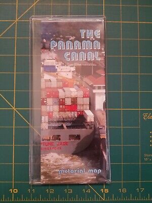
$4.13 Shipping Location: Denver, United States DESCRIPTION/SYNOPSIS/SELLER GUIDELINES © AP6.0 For your bidding consideration and collecting pleasure is a"PICTORIAL MAP OF THE PANAMA CANAL" ... morean official publication of the Panama Canal Commission. January 1997. Map sheet is very faintly rubbed and is very faintly bumped at the extremities; previous owner price on side 2. 1st halve; otherwise, map sheet is in very good condition. Sheet Size: 17 1/4" x 28 1/2" folding to pamphlet. Item photo is actual item photograph. No reserve. PICTORIAL MAP OF THE PANAMA CANAL.Pictorial captions on 1 side: 1. Major Trade Routes 2. Continental Divide 3. Port of Balboa 4. Panama Canal Commission 5. Panama City 6. Miraflores Locks looking North Pedro Miguel Locks in background 7. Pilot on Bridge 8. Miraflores Locks 9. Locomotive with ship 10. Control House Operator 11. Gatun Locks looking Southwest from the Atlantic Ocean. Gatun Lake in background 12. P.C.C. tug assisting Panamax vessel 13. Dredge at work 14. Port of Cristobal 15. Sheet size pictorial map features more specific sites;Side 2 is separated into 2 halves: 1st halve withText titled: 1. PHYSICAL FEATURES OF THE CANAL 2. GENERAL INFORMATION 3. SPECIAL INFORMATON. Inset pictorial is captioned"Panama Canal Profile" 2 full pamphlet-size photographs captioned: 1. A heavily laden container ship(Neptune Jade Singapore) PANAMAX-size, eases into a lock chamber on a northbound transit 2. A Panamax vessel, on a northbound transit, enters Gaillard Cut where the Canal cuts through the Continental Divide-2nd halve with text: 1. THE PANAMA CANAL: THE VITAL LINK FOR WORLD TRADE 2. The Commission 3. Maintenance 4. Maintenance 5. Improvements; photographics are captioned: 1. Cruise passengers get close-up look as vessel enters Pedro Miguel Locks 2. A chamber of Gatun Locks is dewatered during locks overhaul 3. Vessels move through Miraflores Locks under high mast lighting 4. Construction of upper lock at Gatun, Feb
Buy It Now
Free Shipping Location: San Antonio, United States This Map was removed from a 1899 Atlas and is in good acceptable condition. ~ SA-WAR1899/021722. Including Hundreds of RareCivil War. Study the photos ... morecarefully, this is the actual map you will receive.
Buy It Now
$10.20 Shipping Location: Tonawanda, United States 11 3/4" x 9 3/4", with a fold in the center (as issued). The bordered map area is about 10.5" x 8.25" with blank margins all the way around to allow convenient ... morematting. Very good used condition - see photos for condition.
Buy It Now
$4.00 Shipping Location: Harborton, United States ANTIQUE COLLECTIBLE MAP OF JAMAICA, HAITI & SAN DOMINGO.
Buy It Now
Free Shipping Location: Cyprus Bellin was born in Paris. For the complete Map and Print collection see our online site. 33.5 x 20.5 cm. Condition: Fine hand colored copper engraving ... morein overall very good condition. Origin : France edition of Histoire Generale des Voyages.
Buy It Now
$10.20 Shipping Location: Tonawanda, United States 11 3/4" x 9 3/4", with a fold in the center (as issued). The bordered map area is about 10.5" x 8.25" with blank margins all the way around to allow convenient ... morematting. Very good used condition - see photos for condition.
Buy It Now
$30.00 Shipping Location: Paris VI, France Many illustrations of military aircraft and naval vessels. Edition : c. 1930, 20th century.
Buy It Now
$3.35 Shipping Location: Enterprise, United States PUBLISHED DATE 1904. This is an exceptionally nice country map. Map is in very nice condition, very slight age & wear, with great detail. I pride myself ... morein providing optimal protection. I will send a combined invoice reflecting your savings.
Buy It Now
$10.20 Shipping Location: Tonawanda, United States AUSTRO-HUNGARY MONARCHY. 11 3/4" x 9 3/4", with a fold in the center (as issued). The bordered map area is about 10.5" x 8.25" with blank margins all ... morethe way around to allow convenient matting. Very good used condition - see photos for condition.
Buy It Now
$5.00 Shipping Location: Canada DATE OF ISSUE: 1912.
Buy It Now
$24.86 Shipping Location: CHEDDAR, United Kingdom "West Indies Antilles Plans of Ports".
Buy It Now
Free Shipping Location: Monroeville, United States Date - 1889. Publisher - Mitchell. or send resale number.
Buy It Now
Free Shipping Location: Graettinger, United States Rand McNally Standard World Atlas Map.

Buy It Now
Free Shipping Location: Sheridan, United States Fine Caribbean Maps and Prints One Treasure Limited© offers unique and collectible maps. These" Old World Style" maps capture the past ... moreyet chart the exotic destinations of today. We have been in business for over 20 years. Our collection is composed of over forty different maps taken from original watercolor paintings. They are meticulously printed on quality parchment paper. One Treasure Limited owns the original paintings of all our maps. So these prints are made specifically by us. Virgin Islands Map Size: 20" x 27" The U.S. Virgin Islands include St. Thomas. St. John and St. Croix. They have a population of almost 100,000 and a total land area of 134 square miles. Since 1923, their residents have been citizens of the United States. Located about 70 miles east of Puerto Rico, the economy is based on tourism, rum, textiles, pharmaceuticals, and electronics. The capital is Charlotte Amalie on St. Thomas. The British Virgin Islands include Tortola, Virgin Gorda and Anegada with a combined population of 13,000. Please contact us before leaving negative feedback; give us a chance to resolve your problem. Once you leave positive feedback for us. We will leave positive feedback in return asap. On Mar-21-07 at 12:42:29 PDT. Seller added the following information: On Jun-09-08 at 09:07:47 PDT. Seller added the following information:
Buy It Now
$6.05 Shipping Location: Riverside, United States Original 1882 Large Color Map. "Monteith's Course Independent Comprehensive Geography". from the135 year old text.
Buy It Now
$3.25 Shipping Location: Enterprise, United States 1897 Year date printed on map. Blank on reverse (except for map title). The picture does not capture all of the detail in the engraving. very good condition ... more;typical period aging for this old map.

Buy It Now
$3.35 Shipping Location: Enterprise, United States ANTIQUE MAP 1895 FROM THE TIMES ATLAS- CENTRAL AMERICA& WEST INDIES.050 Prev Stop Play Next AN ORIGINAL ANTIQUE MAP DATED 1895. FROM"THE TIMES ... moreATLAS" THE MAP HAS AN OVERALL SIZE OF 412 x 268 mm. THE FRAMEABLE SIZE IS 364 x 245 mm. THE MAP IS IN VERY GOOD CONDITION CONSIDERING IT'S AGE. THE VERY GOOD QUALITY. HEAVYWEIGHT PAPER IT IS PRINTED ON IS VERY SLIGHTLY DIS-COLOURED AT THE OUTER MOST EDGES BUT THIS IS OUTSIDE THE FRAMEABLE PORTION. I WOULD NOT NORMALLY BREAK A BOOK UP BUT UNFORTUNATELY THE BINDING WAS SHOT AND THE COST OF RE-BINDING IT WAS PROHIBITIVE. I HAVE INCLUDED PHOTOS OF THE ORGINAL ATLAS WITH IT'S FRONTISPIECE AND THE PUBLISHING DETAILS. IT WILL BE SENT IN A ROBUST CARDBOARD TUBE. IF YOU WOULD LIKE FURTHER DETAILS AS TO WHAT AREA ANY MAP COVERS THEN PLEASE EMAIL ME AND INCLUDE YOUR EMAIL ADDRESS AND I CAN SEND YOU FURTHER PHOTOS. SPECIAL POSTAGE OFFER IF YOU BUY MORE THAN ONE OF MY MAPS THEN I WILL ONLY CHARGE YOU FOR ONE LOT OF POSTAGE AND ANY OTHER MAPS WILL BE SENT FREE OF CHARGE. PLEASE WAIT FOR ME TO SEND YOU AN INVOICE WITH THE POSTAGE AMENDED ON IT TO REFLECT THIS SPECIAL OFFER BEFORE MAKING ANY PAYMENT. THIS OFFER APPLIES TO OVERSEAS CUSTOMERS AS WELL AS UK CUSTOMERS. Once a bid has been placed. It is a legally binding contract of purchase. Payment must be received within 5 working days of purchase by Paypal only. If payment is not received within 10 days of purchase then a Non-Paying Buyer Dispute will be filed. Goods will be dispatched immediately upon cleared payment. For the majority of items(e.g. jewellery making findings and beads etc.you will pay the full postage price quoted for the first item and only 25p for any additional items(UK) and 50p(Overseas) If you order a lot of items I may be able to reduce the postage even further so it might be worth requesting a total before paying and I will calculate if I can offer you a further discount on postage costs. Refunds will only be given if goods are found to be faulty or not as described. If you should have a
Buy It Now
$4.99 Shipping Location: Fairview, United States Condition: It is in Very Good condition for its age with a centerfold as issued, blank on reverse. The pics are of the actual map. An Original Antique ... moreMap: Not a Modern Reproduction!

Buy It Now
$9.97 Shipping Condition: Unspecified Location: LONDON, United Kingdom Buenos Aires; Rio de Janeiro; Montevideo; Santiago Vintage colour map. 1920 Title of map: Buenos Aires; Rio de Janeiro; Montevideo; Santiago' The ... moreimage below shows an enlarged cross section from the centre of the map to show the level of printed detail: DATE PRINTED: 1920 IMAGE SIZE: Approx 22.0 x 33.0cm. 8.75 x 13 inches(Large) ARTIST/CARTOGRAPHER/ENGRAVER: Unsigned PROVENANCE: Harmsworth's new Atlas" Please note that virtually all antique and vintage maps and prints have been extracted from books. Atlases or newspapers. TYPE: Vintage colour map VERSO: There are images and/or text printed on the reverse side of the picture. In some cases this may be visible on the picture itself(please check the scan prior to your purchase) or around the margin of the picture CONDITION: Good; suitable for framing. Please check the scan for any blemishes prior to making your purchase. Virtually all antiquarian maps and prints are subject to some normal aging due to use and time which is not obtrusive unless otherwise stated. I offer a no questions asked return policy- see below. AUTHENTICITY: This is an authentic historic print. Published at the date stated above. I do not offer reproductions. It is not a modern copy. The term'original' when applied to a print means that it was printed at the first or original date of publication; it does not imply that the item is unique. Print' means any image created by applying an inked block to paper or card under pressure by any method including wood engraving, steel engraving, copperplate, wood cut and lithography. REMARKS: FRANCE: Gravures et Cartes anciennes. DEUTSCHLAND: Alte Lankarten und Stadt ansichten. ITALIA: Stampe& Mappe antiche. ESPAÑA: Mapas antiquos y impresiones antiguas. E and OE. Force Majeure. English law shall apply. RETURNS POLICY: I offer a no questions returns policy. All I ask is that you pay return shipping and mail back to me in original condition. Suitably packed& insured, within 14 days of receipt.
Buy It Now
$22.43 Shipping Location: LONDON, United Kingdom Map of the West Indies published by John Thomson. Sheet size: 32.5 x 25 cm. Excellent condition.
Buy It Now
$5.95 Shipping Location: Morton Grove, United States Souvenir brochure opens to 18" x 24". In good condition. Some edge wear to covers. Based upon research, it appears to be from the 1920's or a bit earlier.
Buy It Now
$6.00 Shipping Location: Columbus, United States (No Date.). This map is in Very Good condition with hand coloring, and with light toning to the edges. The map shows Cuba, Jamaica, Lesser Antilles, Guatemala, ... moreand more, and is held in a clear plastic protective slip.
Buy It Now
Free Shipping Location: North Wales, United States 1895 ANTIQUE "THE TIMES" ATLAS MAP OF THE ANTILLES-EXCELLENT DETAIL ORIGINAL ANTIQUE ATLAS MAP PLEASE SEE PHOTOS AS PART OF THE DESCRIPTION CONDITION: ... moreMAP IS IN GOOD CONDITION. SIZE: APPROXIMATELY 10.5" X 16" SHIPPING: U.S. FIRST CLASS RATE - $6.00 - ANY ITEM WHICH SELLS FOR OVER $100 WILL REQUIRE INSURANCE WE COMBINE SHIPPING FOR MULTIPLE WINS. THANK YOU FOR YOUR INTEREST IN OUR AUCTIONS!.
Buy It Now
$8.12 Shipping Location: Rocky Mount, United States 1 Nautical Map.
Buy It Now
$8.50 Shipping Location: Croatia Nice small map titledGolfe de Nicoya, from wood engraving with fine detail and clear impression. Overall size approx. 19 x 16 cm, image size approx. 11 ... morex 11 cm.
Buy It Now
Free Shipping Location: North Wales, United States 1911 RARE ANTIQUE CRAM ATLAS MAP OF CENTRAL AMERICA-EXCELLENT DETAIL ORIGINAL ANTIQUE ATLAS MAP PLEASE SEE PHOTOS AS PART OF THE DESCRIPTION CONDITION: ... moreMAP IS IN GOOD CONDITION. SIZE: APPROXIMATELY 15" X 23" SHIPPING: U.S. FIRST CLASS RATE - $6.00 - ANY ITEM WHICH SELLS FOR OVER $100 WILL REQUIRE INSURANCE WE COMBINE SHIPPING FOR MULTIPLE WINS. THANK YOU FOR YOUR INTEREST IN OUR AUCTIONS!.
Buy It Now
$13.71 Shipping Location: MANCHESTER, United Kingdom This original antiquemap is from The Weekly Dispatch published in London in 1863. The mapmakers included Edward Weller, John Dower, R.R. Davies and J.W. ... moreLowry. This interesting map is an original antique which is over 160years old.
Buy It Now
$14.99 Shipping Location: Ivanhoe, Australia This large original, beautifully hand coloured copper plate engraved antique map of the Caribbean Islands was published by John Thomson in his large elephant ... morefolio 1817 edition ofA New General Atlas of the World.
|
|
|
|
1807 MAP OF THE WEST INDIES ORIGINAL HAND COLOURED BAHAMAS CARIBBEAN ISLES ETC
WEST INDIES FROM THE BEST AUTHORITIES A copper engraved hand coloured antique map by Barlow centred on the island of Jamaica showing the south eastern part of North America. Most of Central America, and the northern part of South America. Credited within the plate: Engraved by Barlow and Published as the Act directs by C. Brightly& J. Kinnersley. Bungay, Suffolk. This map is not dated but other similar maps which accompanied this map are dated 1807. Condition Three vertical fold lines as issued and blank on reverse. Very slight foxing and a few other slight creases. Size of image is 12¼ by 7½ inches plus margins This item will be mailed folded as issued. PLEASE NOTE We are based in the U.K. G oods are well packaged and sent as soon as payment is accepted. Visit for all our collectable items. Payments must be made within 14 days ... moreof purchase. Thank you for looking.
|
|
|
1762 Gentleman's Magazine October, Map of Siege of Havana
The October 1762 edition of The Gentleman's Magazine published by Sylvanus Urban in London. St. John's Gate. Some cad has torn this issue from a leather volume. A quarter-inch of the leather binding remains. The edition seems complete, from page 453-506. Bound in is"A plan of the Siege of Havana, Drawn by an Officer on the Spot 1762" The map is 10.5"x8.25" and is folded in three parts and is in good condition. For that matter the entire edition is in good shape, without any foxing, or loose pages, excusing the heathen that ripped it from its binding. Some bumped corner pages. See scans. Happy to answer questions. Insurance by request and payment. Thanks for looking!
|
|
|
WEST INDIES : 1898 Antique Original Map Enyclopaedia Britannica Ninth Johnston
West Indies Map. PAGE SIZE: 10 1/2 x 8 1/2 inches. including small margins and Title. SOURCE: The Encyclopaedia Britannica. A Dictionary of Arts, Sciences, and General Literature, Ninth Edition, Edinburgh: Adam and Charles Black. 1898 CONDITION: Good. Few spots of foxing in the margins. See Scan. Sent recorded/signed for by Royal mail which is tracked. On 17-Aug-13 at 19:58:38 BST. Seller added the following information:
|
|
|
Hispaniola Dominican Rep. Santo Domingo and Haiti Map 1695
Original engraved folio page with text and a map of the Island of Hispaniola now Hayti(Haiti) and the Dominican Republic(Santo Domingo) With a complete description of the Island of Porto Rico and Cuba. Folio leaf measures 13 by 18 inches. Please see the pictures. No central visible fold. With minimal creasing to margins, a few spots in the margins not affecting image, some toning and foxing along the edges, but a fine and very attractive antique map. Check out my other items! Be sure to add me to your favorites list!
|
|
|
Hispaniola Dominican Rep. Santo Domingo and Haiti Map 1888
Original engraved map of Jarabacoa and Pico del Valle in the Island of Hispaniola now Hayti(Haiti) and the Dominican Republic(Santo Domingo) In the Cibao region of the country. Map leaf measures 8.5 by 10.5 inches. Please see the pictures. No central visible fold. With minimal creasing to margins, a few spots in the margins not affecting image, some toning and foxing along the edges, but a fine and very attractive antique map. Check out my other items! Be sure to add me to your favorites list!
|
|
|
West Indies Central America Yucatan Cuba 1861 antique engraved hand color map
West-Indien und Central Amerika(Caribbean and Central America) Issued 1861. Gotha by Perthes for Stieler Carthography by Berghaus Scarce antique engraved German map. With lovely original hand color. This 1861 issue of the Stieler map is quite uncommon and much scarcer than issues of the 1870-1890's. The cartography depicted is quite unique to this issue and varies from late issues. Printed on quality paper which retains its inherent structural flexibility and soundness. In Good+ or better condition. Light minor age toning as typical, small mostly light scattered age spotting. The two bottom corners display a light dampstaining which is mostly confined to the blank margins and while it slightly intrudes into the corners it is not visually offensive[note: we grade very conservatively and always seek to disclose any noteworthy flaws] The ... moreprinted area remains visually pleasing. A nice impression of an interesting antique map. Any minor defects along the sheet edges and in the margins may be seen in the photos. Sheet measures c. 17 5/8" W x 14 1/4" H. Engraved area measures c. 16 1/8" W x 13" H. Original fold line as issued. 56306] Guaranteed Authentic! We do not sell modern reprints. Condition All of our items are original antique pieces and it is important to keep in mind that many of them have been around for 100 years or more. Individual pieces may have seen many owners and been handled many times over the course of their existence and as a result each piece has developed a history of it's own. Short edge splits(often repaired with archival tape) Foxing, discoloration, etc. are all things to expect on items of this type. They rarely distract from the piece and often add to the overall character of the item. Keep in mind when you receive your item that you are not handling a modern copy, you are holding a piece of history, an item that has been around for a very long time and will, with proper care, be around for a long time to come. We try to note any significant flaws in the descriptio
|
|
|
Bahama Islands- Original 1891 Coast Chart/map
Original 1891 Coast Chart/map of the Bahama Islands. This chart was published by James H. Stark. Boston. The printed area measures 11" wide x 17" This map is in very fine condition. It was issued folded, but now is mounted on acid free paper. There is very light age toning to the folds. Please see the scan. I also have a many different Bahama Islands antique maps. Some will be listed on eBay this week. I will combine shipping cost.
|
|
|
Canada Caribbean Mexico central America St. Martin Miquelon Guyane original map
Canada Caribbean Mexico central America St. Martin Miquelon Guyane original map 1856 Size: 29x43 cm
|
|
|
Martinique Caribbean Mexico central America Fort de France original map
Martinique Caribbean Mexico central America original map 1856 Size: 28x42 cm
|
|
|
Guadeloupe Caribbean Mexico Martinique central America original map
Guadeloupe Caribbean Mexico Martinique central America original map 1856 Size: 28x43 cm
|
|
|
CENTRAL AMERICA, BELIZE,HONDURAS, RAPKIN & TALLIS, antique illustrated map c1850
CENTRAL AMERICA. BELIZE,HONDURAS, RAPKIN& TALLIS, antique illustrated map c1850, CENTRAL AMERICA. BELIZE,HONDURAS, RAPKIN& TALLIS, antique illustrated map c1850 CENTRAL AMERICA By John Rapkin. Drawn& engraved by John Rapkin and published London circa 1850 by J&F.Tallis. An interesting and desirable map of Central America illustrated with vignette engravings of Belize. Volcano of Isalco and the Great Square of the Antigua, Guatamala. Covers Belize, Guatemala, Honduras, Salvador and Nicaragua. Original outline hand colouring. Fine condition other than light toning to the central fold. A little exaggerated in the scan. Centre fold as issued. Approx. 12.5" x 9.5" 320mm x 240mm) including the borders. With margins beyond. Would frame up beautifully. Please see also close up image. John Rapkin was a mapmaker who was as ... moreconcerned with the aesthetic value of his work as well as cartographic content. His fine maps are distinguished by the trademark decorative borders. Vignettes and title displays. Rapkin worked in close association with the equally respected publisher John Tallis. The publishing rights of many of the maps passed to The London Printing and Publishing Company circa 1850. A GENUINE ANTIQUE MAP GUARANTEED OVER 150 YEARS OLD FROM LINDISFARNE PRINTS FXE1213. We do not deal in reproductions. Facsimiles or modern copies of any kind. SHIPPING. Two items are combined and three items sent by standard shipping free of charge world-wide. Closeups, Shipping Process, Two items are always combined for shipping and three items or more are shipped free of charge. Worldwide"Please see item description for postage costs" Payment Options, All major Credit and debit cards via PAYPAL. Personal cheque drawn on UK banks only. Postal Orders from UK post offices only. Bank transfer- please email for details. About Us, Lindisfarne Prints is a small family business specialising in genuine antique maps and prints at affordable prices.Established in 1995 and trading online since 2000. We pride oursel
|
|
|
Hispaniola Dominican Rep. and Haiti Large Map 1621
Original engraved map of Central America. The Caribbean, part of the United States, with the Islands of Cuba, Jamaica, and Hispaniola now Hayti(Haiti) and the Dominican Republic. Map leaf measures 18 by 23 inches. Please see the pictures. Central visible fold. Creasing to margins, a few spots in the margins not affecting image, some toning and foxing along the edges, but a fine and very attractive antique map. Check out my other items! Be sure to add me to your favorites list!
|
|
|
ANTIQUE ENGRAVED MAP/BATTLE PLAN - AMERICAN CIVIL WAR, CONFEDERATE COLLAPSE 1865
ANTIQUE MAP/BATTLE PLAN. CONFEDERATE COLLAPSE, AMERICAN CIVIL WAR 1865 TYPE: ANTIQUE ENGRAVED MAP/BATTLE PLAN DATE: 1865 PROVENANCE: BATTLE OF THE 19TH CENTURY 1897 PUBLISHED DATE: 1897 CONDITION: VERY GOOD COLOUR: BLACK/WHITE VERSO: TEXT TO REVERSE WITH SLIGHT BLEED THROUGH ALL OVER SIZE(approx) 16cms x 7cms(small) AUTHENTICITY: All printed engravings/prints are originals and not photocopies and in some cases may have discolouring due to age. The word original does not make this item unique. All printed engravings/prints have been removed from books/periodicals and are single pages unless stated otherwise- All prints have been carefully saved and removed from a heavily damaged book. Where possible all explanatory text has been left intact adding to the interest of the print. POSTAGE: FREE WORLDWIDE DELIVERY All prints are sent out in film ... morefront bags and cardboard backed envelopes. We post within 1 business days of cleared payment usually same business day if payment has cleared by 1.00pm. We always obtain proof of posting We value positive feedback so in the unlikely event of any problems after sale. Please let us know before leaving negative or neutral feedback and we will do our best to rectify the problem. Please check our other items for sale. Powered by
|
|
|
West Indies Central America Caribbean Cuba 1892 antique color lithograph map
Westindien und Zentral Amerika Issued 1892. Leipzig by Bibliographisches Institut& Meyers Fine original antique color lithograph map. Printed on quality paper which retains its inherent structural flexibility and soundness. In near VG or better condition. Minor light surface age toning as typical, and some faint trivial staining in the blank margins, overall the image is clean and very attractive[note: we grade very conservatively and always seek to disclose any noteworthy flaws] The printed area remains visually pleasing. A nice impression of an interesting antique map. Any minor defects along the sheet edges and in the margins may be seen in the photos. Sheet measures c. 13" W x 10" H. Printed area measures c. 10 7/8" W x 8 1/4" H. Original fold line as issued. 56237] Guaranteed Authentic! We do not sell modern reprints. ... moreCondition All of our items are original antique pieces and it is important to keep in mind that many of them have been around for 100 years or more. Individual pieces may have seen many owners and been handled many times over the course of their existence and as a result each piece has developed a history of it's own. Short edge splits(often repaired with archival tape) Foxing, discoloration, etc. are all things to expect on items of this type. They rarely distract from the piece and often add to the overall character of the item. Keep in mind when you receive your item that you are not handling a modern copy, you are holding a piece of history, an item that has been around for a very long time and will, with proper care, be around for a long time to come. We try to note any significant flaws in the description, but less noticeable or common characteristics may not be mentioned. As we are a US based company all of our measurements are in Inches. If you need the size in Centimeters please multiply the supplied measurement by 2.53. Payment and Shipping We happily accept PayPal! Payment is appreciated within 5 days of invoicing. Once payment has been received we do our
|
|
|
1790 COPPER ENGRAVED VUE D'OPTIQUE AFRICA TUNISIA TOUR DE GALITE TEMPETE
BEAUTIFUL COPPER ENGRAVED HAND COLORED TITLE VUE PERSPECTIVE D'UNE TEMPETE ET D'UN NAUFRAGE PRES LA TOUR DE GALITE EN AFFRIQUE BASSET- PARIS YEAR: 1780 APPROX SIZE OF SHEET CM 31.3 X 33,4 Normal 0 14 false false false IT X-NONE X-NONE LITTLE DEFECTS OVERALL IN GOOD CONDITION RARE FOR COLLECTOR NS. PRT. N°6053
|
|
|
Hispaniola Dominican Rep. Santo Domingo, Jamaica and Haiti Map
Original double page colored map of the Island of Hispaniola now Hayti(Haiti) and the Dominican Republic(Santo Domingo) on one page and side. With insets of Porto Rico and Jamaica, and South America on the other side in two pages. Includes data on areas and population. Map measures 15 by 22 inches. Please see the pictures. No central visible fold. With minimal creasing to margins, a few spots in the margins not affecting image, some toning and foxing along the edges, but a fine and very attractive antique map. Check out my other items! Be sure to add me to your favorites list!
|
|
|
Wicked old school map of the Bahamas
Beautifully drawn in an antique style. This print would liven up the wall of any mariner enthusiast.
|
|
|
Rare Map The Grenadines and Carribean Map Original Sandra Fisher 1974 Map!!!!!!!
This is a rare map of the Grenadines and the Caribbean by Sandra Fisher dated 1974 this is an original print from the 70's. Comes in the frame the print us in mint condition. It has Sandra Fisher's signature and hand written Copyright 1974 at the bottom. It is not an actual autograph. Printed on heavy stock. Great colors great nautical art great for decorating for a nautical decor or a great addition to your map collection. Make Me An Offer! Any questions please ask. Sold as. No returns payment due at the end of auction. Happy bidding.
|
|
|
Antique 1865 Map: West Indies Jamaica Panama A & C Black Atlas Bartholomew Rare
An Original. Rare 1865 Folio Map of WEST INDIES Jamaica. Panama Railway Provenance Black's General Atlas of The World. Published in Edinburgh: Adam and Charles Black. 1865. Engraved and Printed in Colours by: J. Bartholomew. Edinburgh. Size/ Format Sheet: 445 mm x 310 mm(17.5" x 12.25" Map: 385 mm x 260 mm(15.25" x 10.25" Single-page. Printed on one side of the paper only. Condition Good. Normal age-toning. Very minor sporadic spots/foxing, no tears/creases/folds; otherwise in good condition. ALL OUR ANTIQUE PRINTS AND MAPS ARE ORIGINALS WE DO NOT SELL REPRODUCTIONS OF ANY KIND 2p5ddv.RcmdId ViewItemDescV4,RlogId p4%60bo7%60jtb9%3Fuk%601d72f%2B26rk%3E2p5ddv-1431fcd57d5-0xf6-
|
|
|
Antique 1865 Map Mexico Ctr America Caribbean A & C Black Atlas Bartholomew Rare
An Original. Rare 1865 Folio Map of CENTRAL AMERICA, MEXICO& WEST INDIES Provenance Black's General Atlas of The World. Published in Edinburgh: Adam and Charles Black. 1865. Engraved and Printed in Colours by: J. Bartholomew. Edinburgh. Size/ Format Sheet: 445 mm x 310 mm(17.5" x 12.25" Map: 385 mm x 260 mm(15.25" x 10.25" Single-page. Printed on one side of the paper only. Condition Good. Normal age-toning. Very minor sporadic spots/foxing, no tears/creases/folds; otherwise in good condition. ALL OUR ANTIQUE PRINTS AND MAPS ARE ORIGINALS WE DO NOT SELL REPRODUCTIONS OF ANY KIND.RcmdId ViewItemDescV4,RlogId p4%60bo7%60jtb9%3Fvo%7B%3Dd70f%2Bf52%3E-1431fcd57d2-0xf1-
|
|
|
Rare Original Map of the Bermuda Islands
Rare Original Map of the Bermuda Islands by George F. Cram. Measures 14.37" by 11.25" Attractive and nicely detailed. Will look great in a frame. Free Shipping to anywhere in the US. Your order will always ship within ONE BUSINESS DAY. Well packaged in a sturdy waterproof mailer and sent with a delivery confirmation. I ship worldwide.
|
|
|
1757 Bellin Map of Mexican Empire
1757 Bellin Map- Carte de L'Empire du Mexique J.N. Bellin provided a huge number of maps for L'Abbe Prevost's'Histoire Generale des Voyages' A 25 volume plus work describing the discoveries, journeys and settlements of seventeenth and early eighteenth century European powers. Many of these maps were issued in Dutch and German as well as French. This map of the Mexican Spanish empire comes from a 1757 French edition of"Histoire. Mexico city still appears little different from its time under the Aztecs since there is still a very large lake surrounding it. The northern edge of the map is marked by the town of Durango while Acapulco is in the central south. Vera Cruz is on the Gulf of Mexico shore. There is a nice cartouche title in the lower left. The map measures 8" by 11.5" Has outline hand colouring, a ... morecentrefold(as issued) and is in very good condition. The map is guaranteed to be over 250 years old. Shipping United States- Regular airmail $5.00US. Registered/insured airmail(optional) is an additional US$15.00 for a total of US$20.00. Canada- $3.00US for regular mail. $9.00US for registered mail. Canadian customers please add GST or HST where applicable. Rest of the world- Regular air mail $8.00US. Registered/insured airmail(optional) is is an additional US$15.00 for a total of US$23.00. Terms and Conditions Please note- We can only take responsibility for delivery if the optional registration/insurance is added. Regular airmail is usually very safe and reliable. But items sent by regular airmail are at the buyers risk- regular airmail provides no tracking number, no proof of shipping or delivery, and no insurance in case of loss or damage. Please note- Mailing from Canada to the United States and all other international destinations can sometimes take over three weeks for delivery. We will combine shipment of multiple purchases- several items can be shipped together for one shipping cost. Payment Options We accept Paypal. Beach Antique Maps& Prints International antique m
|
|
|
1750 Bellin Map of the West Coast of South America and Central America
1750 Bellin Map of the West Coast of South America and Central America WE SELL ONLY ORIGINAL ANTIQUE MAPS- NOT REPRODUCTIONS Title: Nouvelle Carte de la Mer Pacifique. Ou Mer du Sud. Description: An uncommon and unusual c. 1750 Jacques Nicholas Bellin map of the western coast of South America and Central America. Oriented to the west. This map illustrates the coast line from Acapulco, Mexico to Valparaiso, Chile. The map is continued via inset at bottom center from Valparaiso to Tierra del Fuego. A text annotation along the Chilean coastline identifies the site where Captain David Cheap, one of Anson's sub-commander's, lost his freighter, the Wager, in 1741. Another inset details the Bay of St. Francois, near Cape Horn, Chile, as discovered by Captain Joachim Durquistade in 1715. At center, near the compass rose, the Galapagos Islands ... moreare prominently presented. Drawn by Bellin for issue in Provost's Histoire Generale des Voyages. Size: Printed area measures 13.5 inches high by 21 inches wide. Condition: Very good. Original platemark visible. Minor wear and verso reinforcement along original fold lines. Offsetting. Blank on verso. Lower half of right margin is narrow. Shipping: Due to recent increases in United States Postal Service rates we have been forced to increase our shipping rates. Shipping rates are not negotiable. Items are shipped within three business days of receiving payment. We are happy to consolidate shipping where possible. The following shipping options are available: 1. USPS Domestic Express Mail(35 USD) USA Only. 2. USPS Priority Mail(15 USD) USA Only. 3. USPS International Express(35 to 55 USD) Recommended service for all international parcels. You will be invoiced at the lowest Express Mail rate possible. 4. USPS Priority Mail(35 USD) Available to only certain countries. Due to high instances of loss. This service is specifically NOT AVAILABLE to MAINLAND CHINA or INDIA. 5. Federal Express is available upon request. This is the only service option available to India and Africa. P
|
|
|
La Giammaica Fogl. IX Antonio Zatta Italian Map of Jamaica 25.5x20.5 (18x13.5)
La Giammaica. Fogl. IX. Antonio Zatta Italian Map of Jamaica 25.5 x 20.5(18" x 13.5" Label on back of Map reads Bolivar Gallery Kingston. Jamaica Art& Book Dealers
|
|
|
Fine Antique Map 1856 Charles Desilver West Indies Hand Colored
Antique West Indies Map 1856 Hand Colored Entered accordingly to the Act of Congress in the year of 1856 by Charles Desilver in the Clerks office of the Discourt Court of the Eastern District of Pennsylvania Very Good Condition. Some minor creasing of the paper. In original condition. Print measures 17-1/4" in length and 13-3/8" in height PLEASE VIEW PHOTOS! Map will be shipped between 2-4 pieces of new stiff cardboard for safekeeping. AM- Cons B.R. RcmdId ViewItemDescV4,RlogId p4%60bo7%60jtb9%3Fvo%7B2d71f%2Bb41%3E-143389eb2a5-0xd6-
|
|
|
ANTIQUE MAP CUBA JAMAICA AND PORTO RICO BY JOHNSON & BROWNING 1859
. 18th Century maps& atlases& prints. ORIGINAL ANTIQUE STEEL PLATE ENGRAVING. HAND COLORED. Engraving is Absolutely Guaranteed authentic original print. A Certificate of Authenticity will be on request forwarded for each individual map or print. Sheet app. 45.5 x 35.5 cm. 18 x 14 inches. Image app. 41.5 x 32 cm. 16 x 12.5 inches. Condition: VG+++ All maps and prints are genuine. Authentic, published at the date stated in this listing! For better quality pictures please go to our web site: WWW.MAPANDMAPS.COM I offer a no questions returns policy. All maps and prints are genuine. Authentic, published at the date stated above. Shipping: Worldwide shipping by signed registered mail or Global Express courier . Standard Int'l Shipping means registered airmail of Europe. If you want to receive the item quickly. Ask for Expedited ... moreInt'l Shipping or a 3 days Shipping by FedEx. between $ 25.95 and $ 38.50) Shipping fee is per combined shipment. Including handling and insurance. Free shipping worldwide if three items or more purchased. . . .
|
|
|
ANTIQUE MAP HAITI CARTE DE LA PARTIE FRANCAISE DE ST. DOMINGUE TARDIEU 1822
. Title: Carte de la Partie Francaise de St. Domingue. Dessinee et Gravee par Ambroise Tardieu. From: Recueil de Plans et Cartes… French Saint Domingue revolution Detailed map of Haiti showing the islands La Navace. La Gonave isle de la Fortue and the eastern end of Cuba. ORIGINAL ANTIQUE COPPER PLATE ENGRAVING. HAND COLORED. Engraving is Absolutely Guaranteed authentic original map. A Certificate of Authenticity will be on request forwarded for each individual map or print. Image app: 46 x 37 cm. 18 x 14.5 inches. Condition: Very good. Fold as published. All maps and prints are genuine. Authentic, published at the date stated in this listing! For better quality pictures please go to our web site: WWW.MAPANDMAPS.COM I offer a no questions returns policy. All maps and prints are genuine. Authentic, published at the date stated above. ... moreShipping: Worldwide shipping by signed registered mail or Global Express courier . Standard Int'l Shipping means registered airmail of Europe. If you want to receive the item quickly. Ask for Expedited Int'l Shipping or a 3 days Shipping by FedEx. between $ 25.95 and $ 38.50) Shipping fee is per combined shipment. Including handling and insurance. Free shipping worldwide if three items or more purchased. . . .
|
|
|
ANTIQUE MAP GUADELOUPE CARTE GENERALE DE LA GUADELOUPE TARDIEU 1822
. From: Recueil de Plans et Cartes… Invasion of Guadeloupe The Invasion of Guadeloupe was a British amphibious operation fought between 28 January and 6 February 1810 over control of the Caribbean island of Guadeloupe during the Napoleonic Wars. The island was the final remaining French colony in the Americas. Following the systematic invasion and capture of the others during 1809 by British forces. During the Napoleonic Wars, the French colonies had provided protected harbours for French privateers and warships, which could prey on the numerous British trade routes in the Caribbean and then return to the colonies before British warships could react. In response, the British instituted a blockade of the islands, stationing ships off every port and seizing any vessel that tried to enter or leave. With trade and communication made dangerous ... moreby the British blockade squadrons, the economies and morale of the French colonies began to collapse, and in the summer of 1808 desperate messages were sent to France requesting aid. ORIGINAL ANTIQUE COPPER PLATE ENGRAVING. HAND COLORED. Engraving is Absolutely Guaranteed authentic original map. A Certificate of Authenticity will be on request forwarded for each individual map or print. Image app: 46 x 37 cm. 18 x 14.5 inches. Condition: Very good. Fold as published. All maps and prints are genuine. Authentic, published at the date stated in this listing! For better quality pictures please go to our web site: WWW.MAPANDMAPS.COM I offer a no questions returns policy. All maps and prints are genuine. Authentic, published at the date stated above. Shipping: Worldwide shipping by signed registered mail or Global Express courier . Standard Int'l Shipping means registered airmail of Europe. If you want to receive the item quickly. Ask for Expedited Int'l Shipping or a 3 days Shipping by FedEx. between $ 25.95 and $ 38.50) Shipping fee is per combined shipment. Including handling and insurance. Free shipping worldwide if three items or more purchased. . . .
|
|
|
Hispaniola Ville de S. Domingue Colored Map
Original engraved map of the Ville De S. Domingue. Now the Santo Domingo in the Island of Hispaniola or the Dominican Republic and Haiti. Map leaf measures 9.25 by 12.50 inches. No central visible fold. Minimal creasing to margins, a few spots in the margins not affecting image, some toning and foxing along the edges, but a fine and very attractive antique map. Check out my other items! Be sure to add me to your favorites list!
|
|
|
Hispaniola Isle de Saint Domingue Colored Map
Original engraved map of the Island of Santo Domingo. Now the Island of Hispaniola or the Dominican Republic and Haiti. Map leaf measures 10.5 by 14.75 inches. No central visible fold. Minimal creasing to margins, a few spots in the margins not affecting image, some toning and foxing along the edges, but a fine and very attractive antique map. Check out my other items! Be sure to add me to your favorites list!
|
|
|
Hispaniola Dominican Rep. Haiti P. Rico Map Figure CXXXIX
Original engraved map of the Island of Hispaniola now Hayti(Haiti) and the Dominican Republic including Puerto Rico. Map leaf measures 5.5 by 8.5 inches. No central visible fold. Minimal creasing to margins, a few spots in the margins not affecting image, some toning and foxing along the edges, but a fine and very attractive antique map. Check out my other items! Be sure to add me to your favorites list!
|
|
|
Hispaniola Isola Spagnola Dominican Rep. and Haiti Map
Original leaf with an engraved map of the Isola Spagnuola. Now the Island of Hispaniola or the Dominican Republic and Haiti. L eaf measures 8 by 11.75 inches. No central visible fold. Minimal creasing to margins, a few spots in the margins not affecting image, some toning and foxing along the edges, but a fine and very attractive antique map. Check out my other items! Be sure to add me to your favorites list!
|
|
|
1901 CHROMOLITHOGRAPH VIEW PANAMA CANAL PANORAMIC ISTHMUS OF DARIEN SASSARDI GAP
ORIGINAL 1901 CHROMOLITHOGRAPH PANORAMIC VIEW OF THE PANAMA CANAL TITLE PANORAMIC VIEW OF THE ATLANTIC COAST OF THE ISTHMUS OF DARIEN FROM CALEDONIA MOUNTAIN TO SASSARDI GAP. TAKEN FROM POINT IN FRONT OF SASSARDI ISSUED AND OR PUBLISHED BY JULIUS BIEN AND U.S. GOVERNMENT 1901 TOP LEFT CORNER"ISTHMIAN CANAL COMMISSION 1899-1900"THIS IS PLATE 16 FROM THE ORIGINAL REPORT ALSO SHOWN IS CALEDONIA MOUNTAIN. CALEDONIA GAP AND SASSARDI GAP MEASURES 40 INCHS x 10 INCHES FAIR-GOOD LOOKS MUCH BETTER THAN THE PICTURES
|
|
|
1794 LARGE Map of the WEST INDIES * LAURIE & WHITTLE East Florida Tecas ORIGINAL
A NEW AND COMPLETE MAP OF THE WEST INDIES COMPREHENDING ALL THE COASTS AND ISLANDS KNOWN BY THAT NAME Map area: 18¼ x 33½"plus margins. Published by Laurie& Whittle. London, 1794. Beautifully detailed. Authentic antique 18thc. map. Large format map of Gulf Coast. Eastern seaboard(from Charleston to Key West) Mexico. Central America, Baja California. Venezuela and the Carribean Sea. Color key. Below decorative title block, indicates Colonial Possessions. Native American tribal names. Islands, banks, shoals, ports, windward pass age and MUCH MORE! Original wash and outline handcolor. Crisp clean impression. Fine old paper has been reinforced on margins and fold lines with archival tape(see last photo) There are a few rather minor edge tears; only one enters map area below California. Overall condition is still VERY GOOD. ... moreSOLD AS SEEN. SOLD AS IS. All sales are final. GUARANTEED original. Over 160 years old. Buy with confidence. we have 100% positive feedback. Flat rate shipping for US only. International okay. With cost depending on location. OTHER METHODS of payment accepted ~ Just ask. Payment due within 3 days of purchase. View seller's OTHER antique map AUCTIONS& eBay store.
|
|
|
1895 Antique Historic Map of the WEST INDIES - Cuba, Jamaica, Puerto Rico, etc.
1895 Antique Historic Map of the West Indies Two pages. Each page is 11" x 14" These are original pages(not a reproduction! from the Philadelphia Public Ledger's Unrivaled Atlas of the World. It was prepared and published especially for The Public Ledger. Philadelphia, PA in 1899, George W. Childs Drexel. Editor and Publisher, by Rand. McNally& Co. Chicago and New York What a great gift for a collector or historian! Unique piece of history! These old maps are becoming harder and harder to find. When framed. It becomes a work of art. Look at the prices of other antique maps. And you will see that this starting price is low in comparison. Will ship rolled in a hard mailing tube. Look at my other maps that are listed. Second and all subsequent maps ship for f ree in the same tube. Happy bidding and thanks for looking!
|
|
|
1890 CENTRAL AMERICA CARRIBEANS CUBA JAMAICA COSTA RICA PANAMA CHANEL Antic Map
Normal 0 21 false false false MicrosoftInternetExplorer4 1890 CENTRAL AMERICA CUBA JAMAICA HAITI BAHAMAS COLUMBIA COSTA RICA Antique Map D E S C R I P T I O N Normal 0 21 false false false MicrosoftInternetExplorer4 THERE ARE NOT ANY SPOTS OR STAINS ON THE PRINT! THIS APPEARS DUE TO THE SCANNER. S OME PART OF THE IMAGE MAY BE CUT DURING THE SCANNING! Normal 0 21 false false false MicrosoftInternetExplorer4 Normal 0 21 false false false MicrosoftInternetExplorer4 Due to the scanner the image is more yellow than in reality. There is a light stripe in the middle of the page. Caused by the scanner. In reality there is a fold in the center. This is an original old German map– a double page book plate. This original. Authentic antique map was a part of old German book. This is NOT a modern reproduction! VERY DECORATIVE. PERFECT FOR FRAMING! The ... moremap is printed in Leipzig. Germany, by the Bibliographishes Institut in 1890 SIZE– apr. 12’ 10’ inches– perfect for framing. There is a fold in the center– the print was folded inside the book. The image presents the area of the print. Which will be visible when it is framed. ABOUT THE CONDITION– please check the scan arefully. SHIPPING We use a tube in order to protect the prints. We ship registered only. For USA and Canada– registered with priority. FEES- $ 8 for 1-3 prints in a tube. $ 19 for up to 20 prints. PAYMENTS Please pay by PAYPAL in a reasonable time after your purchase. We hate to open“non paid item” disputes or cases. But life is not only pleasure L. PLEASE NOTE! After reading this description. If there are any questions. Please ask us BEFORE bidding! If there is a problem with your item before or after it’s receiving. Please contact us ASAP. We’ll give our best to resolve the problem in a friendly manner.
|
|
|
Original c1880 miniature map Santo Domingo city plan by Sir Robert Schomburgk
Original c1880 miniature map Santo Domingo city plan by Sir Robert Schomburgk Santo Domingo. Now known as Santo Domingo de Guzmán. Is the capital and largest city in the Dominican Republic. Sir Robert Schomburgk was appointed British consul at Santo Domingo Size 100 x 83 mm Normal 0 false false false EN-GB X-NONE X-NONE Combined postage available Normal 0 false false false EN-GB X-NONE X-NONE
|
|
|
Original c1880 miniature map Panama Isthmus.
Original c1880 miniature map Panama Isthmus. From'The counties of the World' the map shows the Railway and the proposed line of the Canal between the two Oceans France began work on the canal in 1881. But had to stop because of engineering problems and high mortality due to disease. The United States took over the project in 1904. Size 105 x 78 mm Combined postage available Normal 0 false false false EN-GB X-NONE X-NONE
|
|
|
Gregorio López - Henrion 1847
WWW.STORCHIANTIQUES.COM Title: Gregoire Lopez eveque de Basilee" Date: 1847 Place: Paris Author: Henrion Publisher: Gaume frerer Technique: steel acciaio acier Note: from"Histoire generale des Missions catholiques. Size: Sheet 26.5cm x 18cm Engraving 13cm x 11cm Condition: foxing- water stains to the superior edge(look photo) Condizioni: fioriture- macchie d'umidità sul margine superiore(vedere foto) Conditions: foxing- taches d'humiditè sur la marge supérieure(voir photo) Shipping: If you buy more than one item you have to pay just one only shipping cost(registered mail) Shipping cost: Italy 9 USD Europe 15 USD America(North-South) Africa 17 USD Asia-Oceania 22 USD WE DON'T SELL LASER COPY OR SCANNER. THIS AN ORIGINAL ENGRAVING OF 1847 On Aug-27-07 at 08:51:41 PDT. Seller added the following information:
|
|
|
MARTINIQUE West Indies – 232 Year Old Map, Beautiful hand Coloring
HISTORIC ANTIQUE MAP(genuine) MARTINIQUE* West Indies- Made in 1781- This item is a scarce 1781 map of the West Indies island of Martinique. Located in the Lesser Antilles. Martinique was originally charted by Columbus but subsequently ruled by the French. During the various European wars, it was occupied several times by the British, but each time reverted to French rule and today it is a political division of France. At the time this map was made, Martinique was a colony of France, although 13 years later it would be seized by Britain and held for two decades, only returned to France at the conclusion of the Napoleonic Wars. This map was created by Rigobert Bonne. The official mapmaker for the French Navy, and it shows the island's coast and interior in great detail. The finely engraved features shown include bays, ports, villages and ... moretowns, as well as the interior mountains and rivers. The towns and villages include Fort Royal, Trinite, Vauclain, Marin, Fort St. Pierre, and Marigot. The most prominent feature of the interior region is Mount Pelee which, a little more than a century after this map was made, would erupt and completely devastate the capital city, St. Pierre, killing 30,000 inhabitants of the island. This historic map measures 14 inches high by 10-1/2 inches wide and it is beautifully hand-colored. This map is in absolutely pristine condition. Despite its age. There is a clear plate mark, the laid paper is a uniform light cream color and the(original) centerfold is virtually invisible. There are no flaws of any kind. Moreover. This 233-year-old map is Absolutely Genuine and not any type of reprint or reproduction. PAYMENT AND SHIPPING- Payment by PayPal- Buyer Pays Only Actual Postage Costs! This item will be shipped in several layers of cardboard for protection. Because of the resultant weight and the size of the package. For shipping within the United
|
|
|
West Indies and South America Colored Map
Original colored map with the West Indies on one side and South America on the other side. From the Atlas of the World. Page 205 and 206. Map dimension is 10.5 by 14 inches. No central visible fold. Minimal creasing to margins, a few spots in the margins not affecting image, minimal toning and foxing along the edges, but a fine and very attractive antique map. Check out my other items! Be sure to add me to your favorites list!
|
|
|
West Indies Hurricanes Map 1878-1903
Original map with the Tracks of West Indian Hurricanes October 1878-1903. Including the Island of Hispaniola, now the Dominican Republic and Haiti, Cuba, Jamaica. The Lesser Antilles and Florida. Geographical Society of Baltimore, Plate XXIII. Map dimension is 10 by 13 inches. Central visible fold. Minimal creasing to margins, a few spots in the margins not affecting image, minimal toning and foxing along the edges, but a fine and very attractive antique map. Check out my other items! Be sure to add me to your favorites list!
|
|
|
Costa Rica authentic Antique Map Belize Honduras genuine 123 years old - 1891
CENTRAL AMERICA Authentic 123-Year-Old Antique Map Printed in 1891. This is a beautiful, 123-year-old color map of Central America including British Honduras(modern Belize) Gautemala, San Salvador, Honduras, Nicaragua, Costa Rica, Veragua and Panama(part of Colombia) It measures about 11 by 14 inches(about 28 by 36 cm. and is in Fine condition. It contains a wealth of detail including topographical features, latitude and longitude, cities and villages, routes of old railways, and more. This is a guaranteed genuine antique map! Ideal for genealogy or other historical research. This map was printed on a single sheet of stock and bound whole in an antique book. There are no folds, creases, stains or marks, and the paper is clean and not brittle. A similar map is printed on the reverse. Highly suitable for framing(see sample presentation below) ... morethis map would look great in your office, den or study. It is similar to many of the maps sold in expensive mail-order catalogues and department stores, with one important difference: this is an actual antique. NOT modern reproduction. An excellent investment. This map is certain to appreciate in value over time. Please ask all questions before making your purchase. SAMPLE DISPLAY IDEA SAMPLE DISPLAY IDEA FREE SHIPPING anywhere in the USA by USPS First Class Mail. Priority and Express services also available. Shipped rolled in a sturdy tube. I ship worldwide! iia91a
|
|
|
Antique map of Jamaica - Carte de L'Isle la Jamaique
Purchased from Hills Galleries. 101 harbour St, Kingston, Jamaica in the 1950's. Frame dimensions(outside) 17.25 inches x 12.25 inches. Map dimensions 12.50 x 8 inches(viewable area) Jacques-Nicolas Bellin was a French hydrographer and cartographer. He was born in Paris. In 1721 Bellin was appointed hydrographer(chief cartographer) to the French Navy upon the creation of France's hydrographic office. The Dépôt des cartes et plans de la Marine. Appointed"ingénieur hydrographe" in August 1741. Member of the Académie de Marine and of the Royal Society of London. Over a 50 year career, he produced a large number of maps of particular interest to the Minist ère de la Marine. Description: Copper engraving. Hand colored. Notes: In excellent condition. PACKED TO SHIP! Securely wrapped to prevent breakage. ... moreAdditional packing(UPS Store) $9.00
|
|
|
Rare Original 1891 Map of Cuba, The Bahama Islands, Jamaica, Haiti & Dominica
Rare Original 1891 Map of Cuba. The Bahama Islands, Jamaica, Haiti& Dominica by George F. Cram. Measures 14.5" by 11" Nice color and detail. Rescued and unbound from a vintage atlas. Will look great in a frame. See photo's. Free Shipping to anywhere in the US. Your order will always ship within ONE BUSINESS DAY. Well packaged in a sturdy waterproof mailer and sent with a delivery confirmatio n. I ship worldwide.
|
|
|
DANISH ISLANDS IN THE NORTH ATLANTIC, ICELAND, BY ARCHIBALD FULLARTON 1874.
DANISH ISLANDS IN THE NORTH ATLANTIC Two highly decorative maps showing the islands of Iceland and the Faroes. And below a view of Mount Hecla from Odde. Both are surrounded by vignettes of local life, contemporary costumes, and native birdlife. Produced to accompany Archibald Fullarton's"Royal Illustrated Atlas" published 1874. Measures 460 x 320 mm. See photo for condition. Trimmed at left margin. Small repair to left corner. Original colour. For further information please feel free to contact us. A guaranteed genuine antique map. SEE MORE GENUINE ANTIQUE MAPS AND PRINTS IN MY SHOP stores.ebay.co.uk/londonmapgallery 3c0.RcmdId ViewItemDescV4,RlogId p4%60bo7%60jtb9%3Feog4d71f%2B%3E3c0-14367e6bbbe-0x102-
|
|
|
DUTCH POSSESSIONS IN SOUTH AMERICA AND THE WEST INDIES BY FULLARTON 1874.
DUTCH POSSESSIONS IN SOUTH AMERICA AND THE WEST INDIES Two detailed maps: one showing Curacao. St Martin and other lesser islands in the Leeward and on the north coast of Venezuela; the other is of Dutch Guyana with an inset plan of Paramaribo. At the centre there is a view of the Island of Curacao from the East, and below there is a view of the residence offices of Alhmaar on the river Commewina. They are surrounded by images of natives, local animals, fauna and flora. Produced to accompany Archibald Fullarton's"Royal Illustrated Atlas" published 1874. Measures 460 x 320 mm. See photo for condition. Trimmed at left margin. Small repair to left corner. Original colour. For further information please feel free to contact us. A guaranteed genuine antique map. SEE MORE GENUINE ANTIQUE MAPS AND PRINTS IN MY SHOP stores.ebay.co.uk/londonmapgallery
|
|
|
1866 BEAUTIFUL JOHNSON'S ANTIQUE ATLAS MAP-CENTRAL AMERICA-HANDCOLORED-BORDER
1866 BEAUTIFUL JOHNSON'S ANTIQUE ATLAS MAP-CENTRAL AMERICA-HANDCOLORED-BORDER, Click to View Image Album 1866 BEAUTIFUL JOHNSON'S ANTIQUE ATLAS MAP-CENTRAL AMERICA-HANDCOLORED-BORDER BEAUTIFUL DETAILED RARE JOHNSON'S ATLAS MAP PLEASE SEE PHOTOS AS PART OF THE DESCRIPTION CONDITION: MAP IS IN GOOD CONDITION-NICE VIVID COLOR SIZE: APPROXIMATELY 12" X 17" SHIPPING: U.S. FIRST CLASS RATE- $4.00. CANADA- $9.00. WORLDWIDE- $14.00 WE COMBINE SHIPPING FOR MULTIPLE WINS! THANK YOU FOR YOUR INTEREST IN OUR AUCTIONS! Payment I accept the following forms of payment: PayPal Shipping& Handling $4.00 USPS First-Class Mail® FREE scheduling. Supersized images and templates. Get Vendio Sales Manager. FREE scheduling. Supersized images and templates. Get Vendio Sales Manager. Over 100.000,000 served. Get FREE counters from Vendio ... moretoday!
|
|
|
1853 Map of The WEST INDIES From Smith's Quarto Geography Daniel Burgess & Co.
Up for auction is this wonderful map of The West Indies as it appeared in 1853. Which was carefully removed from a partial copy of SMITH'S QUARTO, OR SECOND BOOK IN GROGRAPHY. A CONCISE AND PRACTICAL SYSTEM OF GEOGRAPHY, FOR COMMON SCHOOLS, ACADEMIES, AND FAMILIES. Designed as a Sequel to the"First Book. NY: Daniel Burgess& Co(Late Cady& Burgess) copyright 1853. As you can see from the scans. The colors are very nice and the map is in good condition. The map is age toned, the bottom border is creased, and there is a stain in the upper border. Please note that the map was too large to fit into my scanner, and there are in fact borders all around the map. The 9.5” x 11.5” map of The West Indies contains a list of the island possessions of Britain. France, Spain, Netherlands, Sweden, and Denmark, which shows that at the time, ... moreother than Haiti, virtually every island in the Caribbean was a colony of a European country. The map would look wonderful framed. I have included the article on the West Indies from wikipedia.org below. This map is a must have for anyone interested in the history of the South America. I am starting the bidding for the map at a very low opening bid. And the map is OFFERED WITH NO RESERVE. From Wikipedia the online encyclopedia: The West Indies. Or West India. Is a region of the and that includes the islands of the and the. 1] After the first of the to the. Europeans began to use the term West Indies to differentiate that region from the( and) West Indies and West India are antiquated. From the 17th through the 19th century. The European of the West Indies were the. The. The(Dutch West Indies) The. And the. In 1916. Sold the Danish West Indies to the United States for US$25 million in gold. As per the. The Danish West Indies became an of the US. Called the. Between 1958 and 1962. The United Kingdom reorganised all their West Indies island territories—except the. And—into the. They hoped that the Federation would become independent as a single nation. However. The F
|
|
|
ANTIQUE MAP ST. VINCENT West Indies Caribbean THOMPSON c1817 Hand? Colored
You are bidding on a very nice hand? colored antique map of the island of St. Vincent. Which was considered part of the"West India Islands" for purposes of Thompson's New General Atlas, 1817, for which this engraving was made. I also have a map of the"West India Islands, including Curacao, Grenada, Trinadad and Tobago from the same period if you are interested. This nearly 200 year old map is in fairly good condition; however, as you can see, it does have some toning and soiling and has been separated from the other half of the page, which would have included a map of Barbados. That said, this is still antique map that would look great in your home or vacation home. The outer dimensions of this unframed map are 12 5/8" by 21. Thanks for looking.
|
|
|
ANTIQUE MAP West Indies Caribbean THOMPSON c1816 Curacao Trinidad Tobago Grenada
You are bidding on a very nice antique map of the"West India Islands" aka the West Indies aka the Caribbean island countries of: Grenada. Trinadad, Tobago and Curacao. As you can see from the detailed photo of the bottom edge of the map, this was"Drawn and Engraved for Thompson's New General Atlas 1816. This nearly 200 year old map is in fairly good condition; however, as you can see, it has been vertically folded down the center, which has resulted in a transfer of some of the ink from side to side. That said, this is still antique map that would look great in your home or vacation home. The outer dimensions of this unframed map are 27 3/4" by 21 1/8. Thanks for looking.
|
|
|
map of gulf of Mexico.....of Dr ROBERTSON (18° c:)
Beautiful map of center America.Mexico and other insels, in good conditions with just a very good restoration in the left hand side The size of the sheet is 21x13 incs The author is Dr ROBERTSON
|
|
|
1882 Blackie’s Atlas, WEST INDIA ISLANDS AND CENTRAL AMERICA, Antique Map
Authentic. Very attractive map taken from a dilapidated copy of The Comprehensive Atlas& Geography of the World by WG Blackie. 1882. It measures 50cm x 34cm approx. Excluding margins. Vertical centrefold as published. No printing on verso. The printed area is in very good condition. The map image is fresh and clean; the odd mark and speck but very minor. The margins are clean but there is some tanning towards the edges and a some foxing spots most apparent in the bottom margin. There is a split at the top of the centrefold as far as the printed map border. Verso clean. The map will be posted rolled in a new posting tube. First class postage is £3.00 plus £1.10 for the tube. I also now have to add on 45p for the ebay 10% commission on P&P cost. I am always delighted to combine postage if customers wish to buy several maps ... moreover a period of time. Many thanks for looking. Any questions. Or if you need more images, then please don’t hesitate to ask.
|
|
|
Central America Map, Hand Coloured, Rand McNally Circa 1875.
Map of Central America hand coloured. 256mm x 335mm, sold unmounted, good condition, pub. Text on the reverse.By Rand McNally& Co. for their New indexed atlas of the world, a couple of small splits in margins Posted with
|
|
|
Original Antique Map of CENTRAL AMERICA Guatemal Honduras Nicaragua Costa Rica
Here is an authentic map that was published in the 1890s. It would be easy to frame for a handsome presentation for your home or office. Map Title: Central America Date: 1890s Publisher: A. K. Johnston Size: 16 x 12 inch page. 12 x 10 inch map. Features: Original antique map. Not a reproduction. Brightly colored in pink, green, orange and yellow tints for an eye-catching display. Details are clearly laid out and include countries, cities, towns, villages, geographical features. Condition: Near Fine. The paper is supple and not brittle. And the entire map area is clean and free of any marks or tears save for some light smudging that is outside the map area. Shipping: The map will be packaged with care and securely mailed within 48 hours of payment. This handsome map is a window into the past that will provide you with many hours of enjoyment ... moreand delight. Not just an historical document. It is also a unique work of art that can be easily framed and proudly displayed. Thanks for looking! I package carefully and ship securely. Please feel free to email me at any time with your thoughts or questions- I am always happy to respond!
|
|
|
100% ORIGINAL WEST INDIES MAP BY W HUGHES C1848 VGC ORIGINAL COLOUR
100% ORIGINAL WEST INDIES MAP BY W HUGHES C1848 240MM X 180MM MAP IN VERY GOOD/FINE CONDITION NO TEARS NO REPAIRS PART OF A COLLECTION LISTED TO BE LISTED OVER THE NEXT FEW WEEKS! GENUINE AUCTION 0.99P START! POSTAGE FOR UK £2.50 2ND RECORDED DELIVERY COMBINED POSTAGE YOU ONLY PAY FOR £2.50 FOR ANY AMOUNT BOUGHT! EUROPE £10.00 RECORDED DELIVERY ANY AMOUNT OF MAPS WORLDWIDE £12.00 RECORDED DELIVERY ANY AMOUNT OF MAPS
|
|
|
Republic of Panama: Large Authentic Detailed Map: Dated 1904: 14" x 22"
1904 Large Color Map Republic of Panama This map is dated 1904 on the face This is a LARGE map. Printed on a single sheet with a fold in the center. Bordered map area is about 20.75" x 13.5" and the map has sufficient margins for matting or framing. Too big for my scanner so scanned in two passes. Resulting scans were then electronically merged. There is NO break in the center of the map. There is a fold. No break in the map; printed on a single sheet with a fold in the center. Scanned in two passes on a tabloid sized scanner and the two scans combined electronically. This color map of Panama was taken from a Cram's atlas published in Chicago by George Cram. A very early map of the Republic of Panama. Which declared independence in 1903(with a little help from Theodore Roosevelt) Route of the projected Panama Canal is shown ... moreas is the as not yet entirely rejected San Blas Route. The map is printed on medium weight paper. And is in very good condition-as shown. Bid with confidence- Returnable for any reason within 10 days for prompt refund(minus shipping charges. Powered by
|
|
|
1656 WEST INDIES Caribbean Antilles Cuba * SANSON antique engraving SMALL GEM!!
LES ISLES ANTILLES. c. ENTRE LESQUELLES SONT LES LUCAYES, ET LES CARIBES par N. SANSON D'ABBEVILLE Map area: 8¼ x 12¼" An ORIGINAL RARE 17thc. engraved map of the Caribbean; with tip of Florida& the Bahamas. Upper left. Trinidad. Tobago, Granada& northern coast of South America, along the bottom. Place names are in French. nice early map! Beautifully engraved; fine old paper. Clean. Excellent impression. Narrow margins; a bit rough on outermost edges. CONDITION IS VERY GOOD++. Flat rate shipping for US only. International okay, with cost depending on location. Payment due within 2 days of purchase. View seller's OTHER ANTIQUE MAP AUCTIONS& Ebay Store. SOLD AS SEEN. SOLD AS IS. GUARANTEED ORIGINAL. NOT a reproduction. Buy with confidence. We have 100% positive feedback.
|
|
|
1561 MAP OF CUBA -ISOLA CVBA NOVA - PTOLEMY(RUSCELLLI) - ORIGINAL
DESCRIPTION: Isola Cvba Nova SOURCE: La Geografia de Claudio Tolomeo. Venice: 1651. MAKER: Girolamo Ruscelli(after Ptolemy) SIZE: The print surface of the map measures approximately 7 1/2 by 9 3/4 inches(H by W) on a slightly larger sheet. CONDITION: Center fold as issued with minor browning on the fold. Text in Italian verso faintly showing through. This an original map published in 1651. Not a facsimile or reproduction. COMMENTS: In the second century A.D. the Greek astronomer Ptolemy was the librarian at Alexandria. The greatest center of learning in the classical world. His Geographia was the first atlas of the world consisting of a compilation of all known geographic information. Rediscovered in the middle ages. His work had a huge impact of the awakening western European mind. Ptolemy's structure for making maps, with longitude ... moreand latitude, and his usual northern orientation for the maps became the standard from then to the present. Although Ptolemy never knew of the island of Cuba, this map of the island is composed using his methods. It is from an Italian translation of the text published by Girolamo Ruscelli(1504-1566) and included 27 maps based on Ptolemy's ancient atlas and 38 maps of the modern world of which this is one. Although Cuba was one of the earliest European discoveries in the New World, in the sixteenth century it was just a stopping off point for the Spanish on the way to the continent in search of riches. Thus, the outline is only an approximation of what we know today, and few towns and places are named, not including the new capitol of Havana. Also shown are Jamaica(here Iamayca) and the western portion of Hispañola(Isola Expañola) A nice example of sixteenth century mapping of the Americas. SHIPPING: We pack carefully and ship by USPS Priority Mail at cost. No international shipping. Please ask if you have any questions.
|
|
|
Caribbean Antique Style Wall Map
Beautiful Caribbean Map! Measures 26 inches by 19.5 inches.Bordered by the United States. Mexico, Central America, and South America, the Caribbean Sea covers almost a million square miles. Its warm waters reach an average depth of 8,448 feet. The lush, windswept islands of the Caribbean are home to more than twenty-five million people. Its larger islands include Cuba, Haiti, the Dominican Republic, Jamaica, and Puerto Rico
|
|
|
Bahamas Antique Style Wall Map
Like New! Never framed or hung. Bahamas Antique-style Wall Map. 30 x 22" A British colony since 1783. The Bahamas became self-governing in 1964 and achieved full independence in 1973. Although it includes 700 subtropical islands and over 2,000 corals and cays, only 29 islands are inhabited. The land area is 5,382 square miles with a population of 253,000. Nassau is the capital and the major industries include tourism, offshore finance and banking. 1 Sheet Rolled.
|
|
|
1876 PANAMA CANAL PROJECT HISTORY Antique Map
i000000. 1876 PANAMA CANAL PROJECT HISTORY Antique Map Click to Enlarge Light stripe on the middle of the print is from the scanner(has original center fold) Original old German map/double page book plate. This is authentic antique(not a modern reproduction)beautiful map comes from a German lexicon. Very decorative.Looks great when framed. Printed by Bibliographisches Institut Leipzig.1876. The overall size of this print with margins approx 12" x 10" inches and suitable for framing. The print was folded inside the book and has original centrefold. Usually I show on the picture that area of print which will be visible in the frame. Condition can be see from the scan. PLEASE NOTE! Shipping $8.00 for 1-3 prints via registered iarmail or the prints will be shipped in a tube up to 20 prints for $14.00 via registered airmail. Your choice. ... moreFOR MULTIPLE BUYERS. All combined items must be paid once a week. If the items are not paid the eBay seller assistant will automatically open a case for unpaid items. After reading all of auction. Please ask any and all questions BEFORE bidding! Thank You If you have questions or problems before OR after you receive an item. PLEASE contact us ASAP. We leave feedback for everyone. Once transaction is complete and feedback has been left for us. We believe in and encourage good communication! We work hard to keep our customers happy! We accept returns ONLY if there is a problem(or damage) on the item. Shipping $8.00 for 1-3 prints via registered iarmail or the prints will be shipped in a tube up to 20 prints for $14.00 via registered airmail. Your choice. Shipping from Europe.Slovakia. Multiple winner safe shipping cost. Please allow approximately two-three weeks for delivery from Europe after payment received. Payment must be received up to 7 days. Payment by PayPal. SORRY but we do not accept eChecks. DO NOT DUPLICATE OR COPY! Template Made By: © Inkfrog Template Center Auction Templates. Logos, Store fronts and more! inkfrog terapeak.
|
|
|
CARIBBEAN & CENTRAL AMERICA: West Indies Bahamas. Jamaica. BLACKIE, 1893 map
The West India Islands. Central America; Inset map of Island of Jamaica Colour Antique map. 1893 Title of map: The West India Islands. Central America; Inset map of Island of Jamaica' The image below shows an enlarged cross section from the centre of the map to show the level of printed detail. This map is folding hence the centrefold line may show on the image below: DATE PRINTED: 1893 IMAGE SIZE: Approx 35.5 x 52.5cm. 14 x 20.75 inches(Large) Please note that this is a folding map. ARTIST/CARTOGRAPHER/ENGRAVER: Unsigned PROVENANCE: Descriptive Atlas of the World and General Geography" prepared under the supervision of W.G. Blackie. PH.D. LL.D. Fellow of the Royal Geographical Societies, London and Edinburgh; Published by Blackie& Son, Limited, London TYPE: Colour Antique map VERSO: There is nothing printed on the reverse side. ... moreWhich is plain CONDITION: Good; suitable for framing. Please check the scan for any blemishes prior to making your purchase. Virtually all antiquarian maps and prints are subject to some normal aging due to use and time which is not obtrusive unless otherwise stated. I offer a no questions asked return policy- see below. AUTHENTICITY: This is an authentic historic print. Published at the date stated above. I do not offer reproductions. It is not a modern copy. The term'original' when applied to a print means that it was printed at the first or original date of publication; it does not imply that the item is unique. Print' means any image created by applying an inked block to paper or card under pressure by any method including wood engraving, steel engraving, copperplate, wood cut and lithography. REMARKS: FRANCE: Gravures et Cartes anciennes. DEUTSCHLAND: Alte Lankarten und Stadt ansichten. ITALIA: Stampe& Mappe antiche. ESPAÑA: Mapas antiquos y impresiones antiguas. E and OE. Force Majeure. English law shall apply. RETURNS POLICY: I offer a no questions returns policy. All I ask is that you pay return shipping and mail back to me in original condition.
|
|
|
JAMAICA, WEST INDIES. J.RAPKIN original antique illustrated map c1850
JAMAICA. WEST INDIES. J.RAPKIN original antique illustrated map c1850 JAMAICA. WEST INDIES. J.RAPKIN original antique illustrated map c1850 JAMAICA By John Rapkin. Drawn& engraved by John Rapkin and published London circa 1850 by The London Printing and Publishing Company. An interesting map of Jamaica illustrated with vignette engravings of Port Antonio. A Sugar Mill, Port Royal Harbour, Kingston, the Seal of the Colony and a flying fish. Original outline hand colouring. Fine condition. Centre fold as issued. Approx. 12.5" x 9.5" 320mm x 240mm) including the borders. With margins beyond. Would frame up beautifully. Please see also close up image. John Rapkin was a mapmaker who was concerned with the aesthetic value of his work as well as cartographic content. His fine maps are distinguished by the trademark decorative borders. ... moreVignettes and title displays. Rapkin worked in close association with the equally respected publisher John Tallis. The publishing rights of many of the maps passed to The London Printing and Publishing Company circa 1850. A GENUINE ANTIQUE MAP GUARANTEED OVER 150 YEARS OLD FROM LINDISFARNE PRINTS FXC1113. We do not deal in reproductions. Facsimiles or modern copies of any kind. SHIPPING. Two items are combined and three items sent by standard shipping free of charge world-wide. Closeups, Shipping Process, Two items are always combined for shipping and three items or more are shipped free of charge. Worldwide"Please see item description for postage costs" Payment Options, All major Credit and debit cards via PAYPAL. Personal cheque drawn on UK banks only. Postal Orders from UK post offices only. Bank transfer- please email for details. About Us, Lindisfarne Prints is a small family business specialising in genuine antique maps and prints at affordable prices.Established in 1995 and trading online since 2000. We pride ourselves on accurate descriptions, good communications, rapid service and fair prices. We are proud to maintain a 100% positive feedback rating which w
|
|
|
1889 Antique Cram Atlas Map of Central America, Cuba, And Central America
Cram 1889 atlas map Size: 11. 5 by 13.5 1889 Antique Cram Atlas Map of California. Nevada And Yellowstone Bid now on this rare. Valuable, authentic, antique map from an 1889 Cram Family Atlas. The atlas map is 11.5 by 13.5 this is an impressive map The map is suitable for framing. We have lots listed so please check them out on eBay. Cram was one of the most skilled and renowned mapmakers of the 19th century. Cram's maps are collectible and sought after by map collectors because of their historical quality engraving, and precise coloring. The fold out maps are 13 by 21.5. thanks for looking. Posted with
|
|
|
HAWAIIAN ISLANDS :1898 Antique Original Colour Map Plate XIII W.& A.K. Johnston
Hawaiian Islands Map. PAGE SIZE: 10 1/2 x 8 1/2 inches. including small margins and Title. SOURCE: The Encyclopaedia Britannica. A Dictionary of Arts, Sciences, and General Literature, Ninth Edition, Edinburgh: Adam and Charles Black. 1898 CONDITION: Good. See Scan. Sent recorded/signed for by Royal mail which is tracked. On 17-Aug-13 at 19:58:38 BST. Seller added the following information:
|
|
|
1865 BEAUTIFUL HAND COLORED STEEL ENGRAVING MEXICO ANTILLES HONDURAS NICARAGUA
BEAUTIFUL STEEL ENGRAVING MAP TITLE MEXIQUE AMERIQUE CENTRAL ANTILLES YEAR: 1865 ENGRAVED ON STEEL BY EBRARD DRAWN BY ED.DUMAS VERZET SIZE OF SHEET CM 29.5 X 24 Normal 0 14 false false false IT X-NONE X-NONE GOOD CONDITION RARE FOR COLLECTOR NS. PRPT. N°5899
|
|
|
1780 Bonne WORLD MAP Mercator Projection, Cartographic Oddities, Very Decorative
PLANISPHERE SUIVANT LA PROJECTION DE MERCATOR 32 cm x 21 cm copperplate enraving. 37.5 cm x 26.5 cm sheet size, modern hand colour, J.L. Pellet, Geneva, 1780 We are pleased to offer this scarce example of the world map compiled by the French cartographer Rigobert Bonne(1727-1795) for the atlas volume that accompanied the profoundly influential Histoire philosophique et politique. Des etablissements et du commerce des europeens dans les deux Indes by(1713-1796) Bonne succeeded Bellin as Chief Royal Hydrogapher at the Depôt de la Marine in 1773 and while his principal focus was on the production of marine charts. He also published general atlases throughout his career. One of the earliest world maps to present the name of the newly established United States(which was still engaged in the Revolutionary War when the map was published) the ... moremap provides a fascinating snapshot of European knowledge of the world at the time with some rather startling misconceptions. This example exhibits hand colour work of the highest order as well as a fine uniform patina and will make an elegant presentation if matted and framed. Among the cartographic curiosities found on the map we see Alaska presented as an island with Greenland connected to the North American continent. The north of which is largely an unknown void. As noted the map identifies the United States(Etats-Unis) to get a sense of map detail consider that the distance from Boston to the island of"Alaschka" as seen below spilling into left map border measures just 9 cm actual size: African interior almost entirely uncharted and Tasmania is shown as a peninsula to Australia: Condition- Please note carefully: Map is in very good condition as can be ascertained from photos. Strong impression with prominent platemark on fine laid paper, image area largely pristine with a few trivial small spots as can be evaluated in photos, centrefold as issued, no text on verso, superb hand colour work. Map exhibits minor faint dampstains and spotting to margins as can be eva
|
|
|
1780 Bonne Map JAMAICA Bold Hachure Engraving For Topography, Fine Hand Colour!
CARTE DE L'ISLE DE LA JAMAIQUE 32 cm x 21 cm copperplate enraving. 37.5 cm x 26.5 cm sheet size, modern hand colour, J.L. Pellet, Geneva, 1780 We are pleased to offer this scarce example of the map of Jamaica compiled by the French cartographer Rigobert Bonne(1727-1795) for the atlas volume that accompanied the profoundly influential Histoire philosophique et politique. Des etablissements et du commerce des europeens dans les deux Indes by(1713-1796) Bonne succeeded Bellin as Chief Royal Hydrogapher at the Depôt de la Marine in 1773 and while his principal focus was on the production of marine charts. He also published general atlases throughout his career. The unusually detailed map is a result of the fact that the Caribbean was a principal focus of Raynal's work. Which proved so controversial that it was banned and publicly ... moreburned owing to its anti-slavery sentiments and criticisms of the Catholic church expressed by the former Jesuit. Published at a time when there were nearly 200,000 slaves in Jamaica, to get a sense of Raynal's rhetoric on the subject of slavery we present an excerpt in translation from the French original: The sacrilegious yoke of oppression shall be broken as the Negro slaves lack only a chief. Sufficiently courageous to lead them on to vengeance and slaughter. Spanish, Portuguese, British, French, Dutch- all these tyrants will become the victims of fire and sword. The plains of America will voraciously soak up the blood which they have long awaited, and the bones of so many wretched victims, heaped upon one another during so many centuries, will leap for joy. The map is notable for its prominent hachure engraving work for the rugged Jamaican topography and is rightly considered one of the most desirable 18th century maps of Jamaica. Printed on top quality hand made laid paper. This attractively hand coloured example exhibits a strong impression with pronounced platemark and will make a fine presentation if matted and framed. Vernon'll meet me when the Boeing lands Key
|
|
|
1780 Bonne Map CUBA Bahamas Fine Engraving & Hand Colour, Decorative & Detailed!
L'ISLE DE CUBA 32 cm x 21 cm copperplate enraving. 37.5 cm x 26.5 cm sheet size, modern hand colour, J.L. Pellet, Geneva, 1780 We are pleased to offer this scarce example of the map of Cuba compiled by the French cartographer Rigobert Bonne(1727-1795) for the atlas volume that accompanied the profoundly influential Histoire philosophique et politique. Des etablissements et du commerce des europeens dans les deux Indes by(1713-1796) Bonne succeeded Bellin as Chief Royal Hydrogapher at the Depôt de la Marine in 1773 and while his principal focus was on the production of marine charts. He also published general atlases throughout his career. The unusually detailed map is a result of the fact that the Caribbean was a principal focus of Raynal's work. Which proved so controversial that it was banned and publicly burned owing to its ... moreanti-slavery sentiments and criticisms of the Catholic church expressed by the former Jesuit. Published at a time shortly after the British greatly expanded slavery in Cuba after the Seven Years War, Cuba was then the main destination of the trans-Atlantic slave trade. To get a sense of Raynal's rhetoric on the subject of slavery we present an excerpt in translation from the French original: The sacrilegious yoke of oppression shall be broken as the Negro slaves lack only a chief. Sufficiently courageous to lead them on to vengeance and slaughter. Spanish, Portuguese, British, French, Dutch- all these tyrants will become the victims of fire and sword. The plains of America will voraciously soak up the blood which they have long awaited, and the bones of so many wretched victims, heaped upon one another during so many centuries, will leap for joy. The map is notable for its elegant design with the littoral waters of all islands densely engraved with horizontal lines for a distinct"3D" effect and is rightly considered one of the most desirable 18th century maps of Cuba. Printed on top quality hand made laid paper. This attractively hand coloured example exhibits a s
|
|
|
1780 Bonne Map HISPANIOLA Haiti, Dominican Republic, Turks & Caicos DECORATIVE!
CARTE DE L'ISLE DE ST. DOMINGUE 32 cm x 21 cm copperplate enraving. 37.5 cm x 26.5 cm sheet size, modern hand colour, J.L. Pellet, Geneva, 1780 We are pleased to offer this scarce example of the map of Hispaniola(today Haiti and the Dominican Republic) Inagua and the Turks and Caicos compiled by the French cartographer Rigobert Bonne(1727-1795) for the atlas volume that accompanied the profoundly influential Histoire philosophique et politique. Des etablissements et du commerce des europeens dans les deux Indes by(1713-1796) Bonne succeeded Bellin as Chief Royal Hydrogapher at the Depôt de la Marine in 1773 and while his principal focus was on the production of marine charts. He also published general atlases throughout his career. The unusually detailed map is a result of the fact that the Caribbean was a principal focus of Raynal's ... morework. Which proved so controversial that it was banned and publicly burned owing to its anti-slavery sentiments and criticisms of the Catholic church expressed by the former Jesuit. It is interesting to note that Raynal is believed to have been a significant influence on Toussaint L'Ouverture who quoted his writing in a 1793 proclamation- to get a sense of Raynal's rhetoric on the subject of slavery we present an excerpt in translation from the French original: The sacrilegious yoke of oppression shall be broken as the Negro slaves lack only a chief. Sufficiently courageous to lead them on to vengeance and slaughter. Spanish, Portuguese, British, French, Dutch- all these tyrants will become the victims of fire and sword. The plains of America will voraciously soak up the blood which they have long awaited, and the bones of so many wretched victims, heaped upon one another during so many centuries, will leap for joy. The map is notable for its pictorial topography and a few cartographic curiosities- in Hispaniola Bonne truncates the peninsula separating the Bahia de Samana from the Bahia de Escocesa and makes it into an island(Ile de Samana) and also consolidates
|
|
|
1705 MAP NICOLAS DE FER -LES ISLES DE L' AMERIQUE HAND COLORED CUBA FLORIDA
TITLE: LES ISLES DE L' AMERIQUE MAP MAKER:NICOLAS DE FER PRINTING YEAR: AROUND 1705 PAGE SIZE:16X11 INCHES
|
|
|
1910 PANAMA RAILROAD COMPANY MAP OF RELOCATED RAILROADS COLON FRENCH CANAL
TITLE PANAMA R.R. CO. RELOCATED LINE GENERAL MAP SHOWING RELOCATED LINE COLON TO BAS OBISPO DATED-JULY 27TH 1910 LOWER RIGHT IN TITLE ISSUED BY OFFICE OF CHIEF ENGINEER COLON RR ENGRAVED AND PRINTED BY THE USGS THIS AUCTION IS FOR AN ORIGINAL MAP FROM 1910 OF THE RELOCATED RAILROADS NEAR THE PANAMA CANAL. MAP SHOWS THE ROUTE OF THE PANAMA RAILROAD AS WELL AS THE LOCATION OF THE RELOCATED ROUTE. ALSO SHOWN IS THE PANAMA CANAL. FRENCH CANAL AND THE CANAL ZONE BOUNDARY. SOME TOWNSHIPS ARE SHOWN INCLUDING COLON, BAS OBISPO, FRIJOLES AND LION HILL. MEASURES 13 X 24 INCHES FAIR-GOOD CONDITION HAS WEAR AT FOLD ON LEFT.AND CREASES
|
|
|
1857 Cowperthwait map of MEXICO, CENTRAL AMERICA, and WEST INDIES ~original map
THE COMMON-SCHOOL GEOGRAPHY: AN ELEMENTARY TREATISE ON MATHEMATICAL. PHYSICAL, AND POLITICAL GEOGRAPHY. Maps JAMES H. YOUNG PHILADELPHIA: PUBLISHED BY H. COWPERTHWAIT& CO 1857 THIS IS AN ORIGINAL MAP NOT A REPRODUCTION Posted with
|
|
|
Caribbean / West Indies Antique Map, 1804 Wilkinson, Hand Colored
For sale is a very nice antique map that was purchased by us in 2008 from an antiques dealer. We had every intention of starting a collection of similar maps from our travels. And unfortunately it hasn't developed as quickly as we'd have liked. It is of the Caribbean& West Indies circa 1804. Each country's territory is denoted by its own color(Spain in yellow. England in red, etc. The size is suitable for framing. And there is nothing printed on the verso. We can ship anywhere in the US via Priority Mail. Securely packaged and unfolded. Please contact us if you have any questions on this item. Thanks for looking! DATE: c1804 SIZE: Approx 21.5 x 27.5cm(8.5 x 10.875 in) CARTOGRAPHER: R. Wilkinson.RcmdId ViewItemDescV4,RlogId p4%60bo7%60jtb9%3Fvo%7B%3Dd70f%2Bf52%3E-143850480ba-0xfd-
|
|
|
Island of Dominica, Caribbean,hand color,B Edwards Map, Antique Original 1794
Original antique engraved and hand colored map titled. MAP OF THE ISLAND OF DOMINICA FOR THE HISTORY OF THE WEST INDIES. Published in"The History, Civil& Commercial of the British Colonies in the West Indies" by Bryan Edwards, London, 1794. Dimensions in inches, 10 x 7 3/4. This is a 219 year old map in excellent condition and to be as described. This is NOT a reproduction. Your purchase will be carefully packed with acid free material. I maintain a 30-day return policy for any reason. ee738) PRINTS AND MAPS WILL BE WELL WRAPPED AND MAILED FLAT. Powered by The free listing tool. List your items fast and easy and manage your active items.
|
|
|
PANAMA COLUMBIA ANTIQUE MAP CARTE DES PROVINCES DE TIERRA FIRME BELLIN 1756
. Title: Carte des Provinces de Tierra Firme. Darien, Cartagene et Nouvelle Grenade Jacques Nicolas Bellin(1703– 21 March 1772) ORIGINAL ANTIQUE MAP HAND COLORED. Map is Absolutely Guaranteed authentic original map. A Certificate of Authenticity will be on request forwarded for each individual map or print. Size: Sheet app. 30.5 x 25 cm. 12 x 10 inches. Image app. 26.5 x 20.5 cm. 10.5 x 8 inches.Condition: Fine hand colored map in very good condition. All maps and prints are genuine. Authentic, published at the date stated in this listing! For better quality pictures please go to our web site: WWW.MAPANDMAPS.COM I offer a no questions returns policy. All maps and prints are genuine. Authentic, published at the date stated above. Shipping: Worldwide shipping by signed registered mail or Global Express courier . Standard Int'l ... moreShipping means registered airmail of Europe. If you want to receive the item quickly. Ask for Expedited Int'l Shipping or a 3 days Shipping by FedEx. between $ 25.95 and $ 38.50) Shipping fee is per combined shipment. Including handling and insurance. Free shipping worldwide if three items or more purchased. . . .
|
|
|
S AMERICA: Patagonia La Plata.Bolivia with Litoral.New Granada/Colombia;1882 map
South America Antique colour map. 1882 Title of map: South America' DATE PRINTED: 1882 IMAGE SIZE: Approx 51.0 x 36.0cm. 20 x 14 inches(Large) Please note that this is a folding map. ARTIST/CARTOGRAPHER/ENGRAVER: Unsigned PROVENANCE: The Comprehensive Atlas& Geography of the world" Compiled and Engraved from the most Authentic sources, under the supervision of W.G. Blackie, Published by Blackie& Son, London. Please note that virtually all antique and vintage maps and prints have been extracted from books, atlases or newspapers. TYPE: Antique colour map VERSO: There is nothing printed on the reverse side. Which is plain CONDITION: Good; suitable for framing. However. Please note: The image shown may have been taken from a different example of this map than that which is offered for sale. The map you will receive is in good ... morecondition but there may be minor variations in the condition from that shown in the image. Please check the scan for any blemishes prior to making your purchase. Virtually all antiquarian maps and prints are subject to some normal aging due to use and time which is not obtrusive unless otherwise stated. I offer a no questions asked return policy- see below. AUTHENTICITY: This is an authentic historic print. Published at the date stated above. I do not offer reproductions. It is not a modern copy. The term'original' when applied to a print means that it was printed at the first or original date of publication; it does not imply that the item is unique. Print' means any image created by applying an inked block to paper or card under pressure by any method including wood engraving, steel engraving, copperplate, wood cut and lithography. REMARKS: FRANCE: Gravures et Cartes anciennes. DEUTSCHLAND: Alte Lankarten und Stadt ansichten. ITALIA: Stampe& Mappe antiche. ESPAÑA: Mapas antiquos y impresiones antiguas. E and OE. Force Majeure. English law shall apply. RETURNS POLICY: I offer a no questions returns policy. All I ask is that you pay return shipping and mail
|
|
|
LA PLATA: Banda Oriental del Uruguay. Paraguay w/o Gran Chaco.Argentina;1882 map
Argentina) La Plata. Chili, Paraguay, Uruguay& Patagonia; Inset map of Continuation of Chili and Patagonia Antique colour map. 1882 Title of map: Argentina) La Plata. Chili, Paraguay, Uruguay& Patagonia; Inset map of Continuation of Chili and Patagonia' DATE PRINTED: 1882 IMAGE SIZE: Approx 51.0 x 36.0cm. 20.25 x 14 inches(Large) Please note that this is a folding map. ARTIST/CARTOGRAPHER/ENGRAVER: Drawn& engraved by J. Bartholomew. Edinr PROVENANCE: The Comprehensive Atlas& Geography of the world" Compiled and Engraved from the most Authentic sources, under the supervision of W.G. Blackie, Published by Blackie& Son, London. Please note that virtually all antique and vintage maps and prints have been extracted from books, atlases or newspapers. TYPE: Antique colour map VERSO: There is nothing printed on the reverse ... moreside. Which is plain CONDITION: Good; suitable for framing. However. Please note: The image shown may have been taken from a different example of this map than that which is offered for sale. The map you will receive is in good condition but there may be minor variations in the condition from that shown in the image. Please check the scan for any blemishes prior to making your purchase. Virtually all antiquarian maps and prints are subject to some normal aging due to use and time which is not obtrusive unless otherwise stated. I offer a no questions asked return policy- see below. AUTHENTICITY: This is an authentic historic print. Published at the date stated above. I do not offer reproductions. It is not a modern copy. The term'original' when applied to a print means that it was printed at the first or original date of publication; it does not imply that the item is unique. Print' means any image created by applying an inked block to paper or card under pressure by any method including wood engraving, steel engraving, copperplate, wood cut and lithography. REMARKS: FRANCE: Gravures et Cartes anciennes. DEUTSCHLAND: Alte Lankarten und Stadt ansichten. ITALIA: St
|
|
|
COLONIAL CARIBBEAN: West Indies. Danish Virgin Islands.Telegraph cables;1882 map
The West India Islands. And Central America; Inset map of Jamaica Antique colour map. 1882 Title of map: The West India Islands. And Central America; Inset map of Jamaica' DATE PRINTED: 1882 IMAGE SIZE: Approx 36.0 x 52.0cm. 14.25 x 20.5 inches(Large) Please note that this is a folding map. ARTIST/CARTOGRAPHER/ENGRAVER: Unsigned PROVENANCE: The Comprehensive Atlas& Geography of the world" Compiled and Engraved from the most Authentic sources, under the supervision of W.G. Blackie, Published by Blackie& Son, London. Please note that virtually all antique and vintage maps and prints have been extracted from books, atlases or newspapers. TYPE: Antique colour map VERSO: There is nothing printed on the reverse side. Which is plain CONDITION: Good; suitable for framing. However. Please note: The image shown may have been taken ... morefrom a different example of this map than that which is offered for sale. The map you will receive is in good condition but there may be minor variations in the condition from that shown in the image. Please check the scan for any blemishes prior to making your purchase. Virtually all antiquarian maps and prints are subject to some normal aging due to use and time which is not obtrusive unless otherwise stated. I offer a no questions asked return policy- see below. AUTHENTICITY: This is an authentic historic print. Published at the date stated above. I do not offer reproductions. It is not a modern copy. The term'original' when applied to a print means that it was printed at the first or original date of publication; it does not imply that the item is unique. Print' means any image created by applying an inked block to paper or card under pressure by any method including wood engraving, steel engraving, copperplate, wood cut and lithography. REMARKS: FRANCE: Gravures et Cartes anciennes. DEUTSCHLAND: Alte Lankarten und Stadt ansichten. ITALIA: Stampe& Mappe antiche. ESPAÑA: Mapas antiquos y impresiones antiguas. E and OE. Force Majeure. English law shall appl
|
|
|
PERU & BOLIVIA W/LITORAL: Pacific War borders.Planned La Paz railway;1882 map
Peru and Bolivia Antique colour map. 1882 Title of map: Peru and Bolivia' DATE PRINTED: 1882 IMAGE SIZE: Approx 36.5 x 51.0cm. 14.5 x 20 inches(Large) Please note that this is a folding map. ARTIST/CARTOGRAPHER/ENGRAVER: Unsigned PROVENANCE: The Comprehensive Atlas& Geography of the world" Compiled and Engraved from the most Authentic sources, under the supervision of W.G. Blackie, Published by Blackie& Son, London. Please note that virtually all antique and vintage maps and prints have been extracted from books, atlases or newspapers. TYPE: Antique colour map VERSO: There is nothing printed on the reverse side. Which is plain CONDITION: Good; suitable for framing. However. Please note: The image shown may have been taken from a different example of this map than that which is offered for sale. The map you will receive is ... morein good condition but there may be minor variations in the condition from that shown in the image. Please check the scan for any blemishes prior to making your purchase. Virtually all antiquarian maps and prints are subject to some normal aging due to use and time which is not obtrusive unless otherwise stated. I offer a no questions asked return policy- see below. AUTHENTICITY: This is an authentic historic print. Published at the date stated above. I do not offer reproductions. It is not a modern copy. The term'original' when applied to a print means that it was printed at the first or original date of publication; it does not imply that the item is unique. Print' means any image created by applying an inked block to paper or card under pressure by any method including wood engraving, steel engraving, copperplate, wood cut and lithography. REMARKS: FRANCE: Gravures et Cartes anciennes. DEUTSCHLAND: Alte Lankarten und Stadt ansichten. ITALIA: Stampe& Mappe antiche. ESPAÑA: Mapas antiquos y impresiones antiguas. E and OE. Force Majeure. English law shall apply. RETURNS POLICY: I offer a no questions returns policy. All I ask is that you pay return shipping a
|
|
|
Cuba Jamaica Puerto Rico Caribbean c.1884 antique hand color engraved map
Cuba. Jamaica and Porto Rico Issued c.1884. Philadelphia by O.W Gray and Son Fine original antique engraved and lithographed map with original hand color. Printed on quality paper which retains its inherent structural flexibility and soundness. In near VG or better condition. Minor light surface age wear, some age toning as typical and faint scattered foxing primarily in the blank margin, overall the image is clean and very attractive[note: we grade very conservatively and always seek to disclose any noteworthy flaws] On the back is a portion of a different map. The printed area remains visually pleasing. A nice impression of an interesting antique map well worth of display. Any minor defects along the sheet edges and in the margins may be seen in the photos. Sheet measures c. 17 1/4" W x 13 3/4" H. Engraved area measures c. 16 ... more1/4" W x 12 3/8" H. 57810] Guaranteed Authentic! We do not sell modern reprints. Condition All of our items are original antique pieces and it is important to keep in mind that many of them have been around for 100 years or more. Individual pieces may have seen many owners and been handled many times over the course of their existence and as a result each piece has developed a history of it's own. Short edge splits(often repaired with archival tape) Foxing, discoloration, etc. are all things to expect on items of this type. They rarely distract from the piece and often add to the overall character of the item. Keep in mind when you receive your item that you are not handling a modern copy, you are holding a piece of history, an item that has been around for a very long time and will, with proper care, be around for a long time to come. We try to note any significant flaws in the description, but less noticeable or common characteristics may not be mentioned. As we are a US based company all of our measurements are in Inches. If you need the size in Centimeters please multiply the supplied measurement by 2.53. Payment and Shipping We happily accept PayPal! Payment is
|
|
|
ORIGINAL 1762 Antique Map of Cuba by John Gibson - Mapa de Cuba Caribbean
An original engraved map of Cuba by John Gibson. Printed in 1762. Title: A New Map of the Island of Cuba with Correct Plans of all the Principal Ports and Harbours it Contains. The attractive map includes ten inset charts of ports and bays. Each with soundings and a compass rose. The verso of the map is blank. This is an original 18th century engraved map and not a modern facsimile. Size of the engraved area. Not including margins: 29.8 x 34.5 cm I am starting the bidding at a modest £49.99 for this excellent example of a map that is now 251 years old! Buy with confidence: Should you not be happy with your purchase. For whatever reason, return it to us within fourteen days for a full refund(including postage costs only if the fault was with our description) Payment: We accept payment by Paypal and Pound Sterling cheque only. Or you may ... morepay on collection at our gallery in Gosport, Hampshire UK. We are happy to combine postage costs if you have bought more than one item from us. Postage: UK: Royal Mail 1st Class 60p Europe: Royal Mail Airmail £1.70 Rest of the World: Royal Mail Airmail £2.50 We are Richard Martin Gallery and have been established since 1980 operating from premises in Gosport. Hampshire. View our website at www.richardmartingallery.co.uk
|
|
|
ORIGINAL 1762 Antique Map of the West Indies by John Gibson - Caribbean
An original engraved map of the West Indies by John Gibson. Printed in 1762. The map is hand coloured and includes an attractive decorative title cartouche. Separate compass rose and scale-of-distance. The verso of the map is blank. This is an original 18th century engraved map and not a modern facsimile. Size of entire sheet including margins: 20.6 x 25.7 cm I am starting the bidding at a modest £39.99 for this excellent example of a map that is now 251 years old! Buy with confidence: Should you not be happy with your purchase. For whatever reason, return it to us within fourteen days for a full refund(including postage costs only if the fault was with our description) Payment: We accept payment by Paypal and Pound Sterling cheque only. Or you may pay on collection at our gallery in Gosport, Hampshire UK. We are happy to combine postage ... morecosts if you have bought more than one item from us. Postage: UK: Royal Mail 1st Class 60p Europe: Royal Mail Airmail £1.70 Rest of the World: Royal Mail Airmail £2.50 We are Richard Martin Gallery and have been established since 1980 operating from premises in Gosport. Hampshire. View our website at www.richardmartingallery.co.uk
|
|
|
ORIGINAL 1762 Antique Map of Martinique by John Gibson - Caribbean Carte
An original engraved map of Martinique by John Gibson. Printed in 1762. The map is hand coloured and includes an attractive decorative title cartouche. Separate compass rose and scale-of-distance. The verso of the map is blank. This is an original 18th century engraved map and not a modern facsimile. Size of entire sheet including margins: 12.8 x 20.3 cm I am starting the bidding at a modest £39.99 for this excellent example of a map that is now 251 years old! Buy with confidence: Should you not be happy with your purchase. For whatever reason, return it to us within fourteen days for a full refund(including postage costs only if the fault was with our description) Payment: We accept payment by Paypal and Pound Sterling cheque only. Or you may pay on collection at our gallery in Gosport, Hampshire UK. We are happy to combine postage ... morecosts if you have bought more than one item from us. Postage: UK: Royal Mail 1st Class 60p Europe: Royal Mail Airmail £1.70 Rest of the World: Royal Mail Airmail £2.50 We are Richard Martin Gallery and have been established since 1980 operating from premises in Gosport. Hampshire. View our website at www.richardmartingallery.co.uk
|
|
|
ORIGINAL 1762 Antique Map of Jamaica by John Gibson - Caribbean West Indies
An original engraved map of Jamaica by John Gibson. Printed in 1762. The map is hand coloured and includes an attractive decorative title cartouche. Separate compass rose and scale-of-distance. The verso of the map is blank. This is an original 18th century engraved map and not a modern facsimile. Size of entire sheet including margins: 12.4 x 20.7 cm I am starting the bidding at a modest £39.99 for this excellent example of a map that is now 251 years old! Buy with confidence: Should you not be happy with your purchase. For whatever reason, return it to us within fourteen days for a full refund(including postage costs only if the fault was with our description) Payment: We accept payment by Paypal and Pound Sterling cheque only. Or you may pay on collection at our gallery in Gosport, Hampshire UK. We are happy to combine postage costs ... moreif you have bought more than one item from us. Postage: UK: Royal Mail 1st Class 60p Europe: Royal Mail Airmail £1.70 Rest of the World: Royal Mail Airmail £2.50 We are Richard Martin Gallery and have been established since 1980 operating from premises in Gosport. Hampshire. View our website at www.richardmartingallery.co.uk
|
|
|
mer du sud panama guayaquil
Genuine map of the 18° century showing part of centre America.The south sea till Guayaquil. The author was Robertson. The size of the sheet is16x11 inc.
|
|
|
c1890 CENTRAL AMERICA West Indies Caribbean Cuba Haiti Antique Map MEYERS
Photo gallery c1890 CENTRAL AMERICA West Indies Caribbean Cuba Haiti Antique Map MEYERS Year ca 1890 From Meyers konversations lexikon Type Antique map Condition Good(as seen on the scan- upper left corner is torn) The map was folded inside the book and has original centrefold. Reverse Side: smaller map Paper thinckness normal Size with margins(inches) approximately: 12.2 x 9.4 inches Size with margins(cm) approximately: 31 x 24 cm- If You are interested In more than one item. Don’t worry we will combine shipping costs for You. Once You have finished shopping please let us know. And we will send an invoice with a combined shipping cost. We are always trying to ship ASAP(within 1-2 business days) All of our orders will be shipped well protected(flat cardboard envelopes or tubes) We are always shipping via registered mail and we will provide ... moreYou with a tracking number. unfortunately not all countries track packages) To the US we are shipping via USPS. We are shipping to the address from the PayPal payment- Remember that all the items are shipped from Europe(Poland) On average it takes between 7 to 14 business days for the package to reach You(but once the item is sent we do not have any control over possible delays) Shipping rates for combined shipping: 1-3 prints: 10 $ 4-6 prints: 11 $ 7-9 prints: 12 $ and so forth. We accept PayPal payments- The payment is appreciated within 5 business days If You are interested in buying more prints. Please don’t hesitate to write. We are open to offers and willing to haggle over prices: We are a small family business located in a Polish capital. Selling and buying antiques has been our profession for over 20 years. We love what we do. And are always trying to provide the best service possible. We offer a huge variety of old prints. If there’s something we don’t have, just ask we might be able to find it for You. Somos una pequena empresa localizada en capital de Varsovia. La compra- venta de antiquedades ha sido nuestro trabajo por mas de
|
|
|
1849 Anitque Map of MEXICO Guatimala WEST INDIES Hand Colored VG Condition
Here is an authentic 164 year old Map of Mexico. Guatimala and the West Indies! This brightly colored map is an original antique document and not a reproduction or copy. It showcases the countries. States, territories, railroads and cities that made up the region in 1849. Unlike many maps of this era, the 1849 date is boldly printed along the lower left edge. The map was published just after the Civil War by S. Augustus Mitchell. Mr. Mitchell was one of a handful of 19th century cartographers who made his fortune producing accurate. Finely detailed maps and atlases. The map features muted hand-painted colors and old-fashioned lettering. It is easy to read and offers more detail than many maps of this vintage. It will frame beautifully; it is an exceptional piece of history measuring 9 x 11.5 inches. Condition is Very Good. The paper is clean ... moreand supple and the white is quite bright. There are no significant marks. Tears or folds. All in all. An outstanding antique map for your collection! Shipping: The map will be packaged with care and securely mailed within 48 hours of payment via Priority Mail. Thanks for looking! Please feel free to email me at any time with your thoughts or questions- I am always happy to respond! Powered by The free listing tool. List your items fast and easy and manage your active items.
|
|
|
Antique map of WEST INDIES from "ATLAS to GUTHRIE'S GEOGRAPHICAL GRAMMAR" 1804
A General Map of WEST INDIES from"AN ATLAS to GUTHRIE'S GEOGRAPHICAL GRAMMAR" 1804 Antique copperplate map(Plate XXVI) engraved for G. and J. Robinson. Pater-Noster-Row, and J. Mawman(Successor to Mr. Dilly) Poultry. London. 1804. Map in fair condition for its age being over 200 years old. Came from a dismembered atlas. Blank on reverse. Centre fold. Overall size including margins: about 10.1 x 8.5 ins. Also shown are images of(1) The contents page of a List of maps in this Atlas. 2) bottom of this page showing Publication details and date. Note: This contents page list is NOT FOR SALE. Please see my other auctions for similar. PAYPAL only. UK P&P £1.30. Combined postage for up to 5 similar maps. Bid now for an historic map suitable for framing for the collector and time-traveller
|
|
|
1890 small map of " west indies & central america " by john bartholmew 1890
this is a nice small map which has come out of a leather bound publication titled" handy reference atlas of the world" by john bartholomew and published by john walker and co in 1890.the map measures 8.5" 7" this is in nice used condition and comes with the tissue joiner on the back. i have many more maps and items you can view in my ebay shop!Be sure to add me to your!Check out my! Powered by
|
|
|
Central America Nicaragua Panama Honduras 1882 antique color lithograph map
Central Amerika(Honduras. Guatemala, Panama& Costa Rica) Issued 1882. Amsterdam, by G.L. Funke Fine original antique color lithograph map. A wonderful example of an uncommon Dutch issued map. Printed on quality paper which retains its inherent structural flexibility and soundness. In near VG or better condition. Minor light surface age wear as typical, some light age toning in the blank margin, overall the map remains clean and very attractive, well worthy of ownership and display[note: we grade very conservatively and always seek to disclose any noteworthy flaws] The printed area remains visually pleasing. A nice impression of an interesting antique and uncommon map. Any minor defects along the sheet edges and in the margins may be seen in the photos. Sheet measures c. 7 7/8" W x 4 7/8" H. Printed area measures c. 6" W ... morex 4" H. 58358] Guaranteed Authentic! We do not sell modern reprints. Condition All of our items are original antique pieces and it is important to keep in mind that many of them have been around for 100 years or more. Individual pieces may have seen many owners and been handled many times over the course of their existence and as a result each piece has developed a history of it's own. Short edge splits(often repaired with archival tape) Foxing, discoloration, etc. are all things to expect on items of this type. They rarely distract from the piece and often add to the overall character of the item. Keep in mind when you receive your item that you are not handling a modern copy, you are holding a piece of history, an item that has been around for a very long time and will, with proper care, be around for a long time to come. We try to note any significant flaws in the description, but less noticeable or common characteristics may not be mentioned. As we are a US based company all of our measurements are in Inches. If you need the size in Centimeters please multiply the supplied measurement by 2.53. Payment and Shipping We happily accept PayPal! Payment is appreciated wit
|
|
|
1906 MAP OF WEST INDIES CARIBBEAN ANTILLES PUERTO RICO COSTA RICA PANAMA FLORIDA
1906 MAP OF WEST INDIES CARIBBEAN ANTILLES PUERTO RICO COSTA RICA PANAMA FLORIDA This original antique map gives you an opportunity to examine in exquisite detail a piece of history. If you are interested in the past of this country and its people or have a desire to study where your family may have come from. Then this map gives you a rare look as the area was about 100 years ago. Once matted and framed, this map would make a perfect gift for a family member or friend they'll cherish forever. Origin of the map: Andree's Allgemeiner Handatlas" Published in Leipzig, Germany by Velhagen& Klasing. Date of issue: 1906 Size: The sheet measures 22" x 17" 56 x 44 cm) S/H: The map will be shipped by Air Mail. The shipping charge is: USA- 8.00. World/Canada- 9.00. The price includes the insurance and a strong, cardboard ... moretube with plastic plugs. Attention! There is no additional shipping charge for multiple purchases! Pay me securely with any major credit card through PayPal! Payment methods: US/Canada Buyers: Paypal. International Buyers: Paypal. Click Here. Double your traffic. Get Vendio Gallery- Now FREE!
|
|
|
Rare Map of The West India Islands b/w South America by W & A.K Johnston 1899
Rare Map of The West India Islands b/w South America by W& A.K Johnston 1899. Measures 14.25" by 11" A rare and attractive map that will look great in a frame. See photo's. Free Shipping to anywhere in the US. Your order will always ship within ONE BUSINESS DAY. Well packaged in a sturdy waterproof mailer and sent with a delivery confirmation. I ship worldwide.
|
|
|
ca 1890 CUBA JAMAICA PUERTO RICO Antique Map MEYERS
Photo gallery ca 1890 CUBA JAMAICA PUERTO RICO Antique Map MEYERS Year ca 1890 From Meyers konversations lexikon Type Antique map Condition Good(as seen on the scan) Reverse Side: blank Paper thinckness normal Size with margins(inches) approximately: 9.5 x 6,3 inches Size with margins(cm) approximately: 24.2 x 16 cm- If You are interested In more than one item. Don’t worry we will combine shipping costs for You. Once You have finished shopping please let us know. And we will send an invoice with a combined shipping cost. We are always trying to ship ASAP(within 1-2 business days) All of our orders will be shipped well protected(flat cardboard envelopes or tubes) We are always shipping via registered mail and we will provide You with a tracking number. unfortunately not all countries track packages) To the US we are shipping via USPS. We are ... moreshipping to the address from the PayPal payment- Remember that all the items are shipped from Europe(Poland) On average it takes between 7 to 14 business days for the package to reach You(but once the item is sent we do not have any control over possible delays) Shipping rates for combined shipping: 1-3 prints: 10 $ 4-6 prints: 11 $ 7-9 prints: 12 $ and so forth. We accept PayPal payments- The payment is appreciated within 5 business days If You are interested in buying more prints. Please don’t hesitate to write. We are open to offers and willing to haggle over prices: We are a small family business located in a Polish capital. Selling and buying antiques has been our profession for over 20 years. We love what we do. And are always trying to provide the best service possible. We offer a huge variety of old prints. If there’s something we don’t have, just ask we might be able to find it for You. Somos una pequena empresa localizada en capital de Varsovia. La compra- venta de antiquedades ha sido nuestro trabajo por mas de 20 anos. Estamos totalmente dedicados a lo que hacemos. Tenemos muchisimas graficas en nuestra oferta. Si hay alguna
|
|
|
c1788 Map Of Mexico & Central Mexico or New Spain
Title: Partie Meridionale de l’Ancien Mexique ou de la Nouvelle Espagne Cartographer: Rigobert Bonne Date and Place: c1788; Paris Publisher: unk Reference: Atlas Encyclopedique… Dimensions& Type: 8 x 12.5 inches(23x 33 cm) BW copper-plate engraving. Likely engraved by Andre. Condition: VG+ on heavy stock Description: Mexico and Central America from the Tropic of Cancer to Panama. The very tip of Baja showing and noting St Lucas. Nice detail with the old style“mole-hill” mountain depiction. This alternate source for this plate may be a later edition of Prevost’s“Histoire Generale des Voyages” as this bears the mark Vol VI. X. Plate no, 27. The same map with the same dimensions was present in both works, The Histoire’s date is 1789-90. Also visit“mapseller01” or Google“Pacific Shore Maps” for more cartography
|
|
|
West Indies Caribbean Cuba Antilles Haiti 1882 antique color lithograph map
West-Indie(West Indies-Antilles. Jamaica, Cuba& Bahamas) Issued 1882. Amsterdam, by G.L. Funke Fine original antique color lithograph map. A wonderful example of an uncommon Dutch issued map. Printed on quality paper which retains its inherent structural flexibility and soundness. In near VG or better condition. Minor light surface age wear as typical, some light age toning in the blank margin as well as some very faint browning along the fold line, overall the map remains clean and very attractive, well worthy of ownership and display[note: we grade very conservatively and always seek to disclose any noteworthy flaws] The printed area remains visually pleasing. A nice impression of an interesting antique and uncommon map. Any minor defects along the sheet edges and in the margins may be seen in the photos. Sheet measures c. 9 3/4" ... moreW x 7 3/4" H. Printed area measures c. 7 7/8" W x 6" H. Original fold line as issued. 58373] Guaranteed Authentic! We do not sell modern reprints. Condition All of our items are original antique pieces and it is important to keep in mind that many of them have been around for 100 years or more. Individual pieces may have seen many owners and been handled many times over the course of their existence and as a result each piece has developed a history of it's own. Short edge splits(often repaired with archival tape) Foxing, discoloration, etc. are all things to expect on items of this type. They rarely distract from the piece and often add to the overall character of the item. Keep in mind when you receive your item that you are not handling a modern copy, you are holding a piece of history, an item that has been around for a very long time and will, with proper care, be around for a long time to come. We try to note any significant flaws in the description, but less noticeable or common characteristics may not be mentioned. As we are a US based company all of our measurements are in Inches. If you need the size in Centimeters please multiply the supplied meas
|
|
|
Jamaica & Barbados Replica J.Speed 17c. Old Map ALL HAND COLOURED A UNIQUE Gift?
DESCRIPTION NB. The red writing across the centre of this map is a'watermark' and will not appear on your purchase. You are bidding on an exquisite Hand Coloured Reproduction of the John Speed original. The size and detail are faithfully reproduced from an original. Please note that the red writing in the centre of this map will NOT appear on your purchase. This is a beautiful representation of'Jamaica and Barbados' from a copy of Speed's Prospect of the World from 1676. This stunning double map of Jamaica and Barbados is one of a small group added to last edition of the Prospect. The additions included India. Russia, Palestine, and four maps of the king?s dominions[American] abroad: Carolina, New England, Virginia, and Jamaica. British engraver Francis Lamb engraved the present map, carrying on the tradition of decorative ... moreelegance for which Speed works are so prized. The map features elaborate title cartouches with the British royal coat of arms and wonderful delineations of topography in the form of small icons of trees and mountains. Jamaica also shows the seventeenth-century British precincts. The top portion of this map shows a map of Jamaica. Whilst Barbados occupies the lower half. The boundaries of the'precincts' of Jamaica are all marked out, and their villages. Ports, bays hills and rivers are too shown. On the map of Barbados. Scotland district with its rugged terrain is shown, as well as Bridg Town(Bridgetown) Hole Town, Spickes Town(Speightstown) and Austenes(Oistins) This map was in use before the advent of motor cars. Railways and canals. John Speed was the most famous of all English map-makers. He published an atlas of the counties of Britain, entitled"The Theatre of the Empire of Great Britaine" in 1611 and followed it with'Prospect of the most famous parts of the world' in 1627. His original maps are highly prized and fetch many hundreds of pounds when they come on the market. Here you have the opportunity to own a hand coloured facsimile for a fract
|
|
|
Jamaica & North & South America 17c. Reproduction Maps from Cadbury
My guess this was obtained in the early 1970's from a Cadbury offer. It is two maps one on each side. It has been folded rolled up probably for the past 40 years as a guess. I have taken pictures of all sides. Because it has been rolled up i have used items to keep it flat for the pictures. As you can see it is in good condition. The edges have slight discolouration/ creasing. But if framed that is not going to be noticed.
|
|
|
1679 Duval Map of the West Indies, Caribbean
1679 Du Val Map-Insulae Antiiles Pierre Du Val was a nephew and pupil of the greatest of all French cartographers. Nicolas Sanson, and went on to become the Royal Geographer. He published many atlases in all sizes but one of his great achievements was the two volume'Geographie Universelle' first published in 1660, these charming little maps are very distinctive. This very nice map of the West Indies comes from a 1679 edition of that atlas. The map covers the whole of the Caribbean from southern Florida through the Bahamas. Cuba, Jamaica, Hispaniola, Puerto Rico and both the Windward and Leeward Isles. There is a simple title at the top right the map. The map measures 4" by 5" with a centrefold(as issued) Has wash hand colouring and is in very good condition. The map is guaranteed to be over 330 years old. Shipping United ... moreStates- Regular airmail $5.00US. Registered/insured airmail(optional) is an additional US$15.00 for a total of US$20.00. Canada- $3.00US for regular mail. $9.00US for registered mail. Canadian customers please add GST or HST where applicable. Sorry, we cannot arrange for pick up of ebay items. Rest of the world- Regular air mail $8.00US. Registered/insured airmail(optional) is is an additional US$15.00 for a total of US$23.00. Terms and Conditions Please note- We can only take responsibility for delivery if the optional registration/insurance is added. Regular airmail is usually very safe and reliable. But items sent by regular airmail are at the buyers risk- regular airmail provides no tracking number, no proof of shipping or delivery, and no insurance in case of loss or damage. Please note- Mailing from Canada to the United States and all other international destinations can sometimes take over three weeks for delivery. We will combine shipment of multiple purchases- several items can be shipped together for one shipping cost. Payment Options We accept Paypal. Beach Antique Maps& Prints International antique map and print dealers for over 25 years Please check our other ma
|
|
 |