-
Christian Collectibles
-
Christian Sheet Music
-
Vatican Stamps
-
Vatican Coins & Paper Money
-
Antiques
-
Antiquities
-
Architectural & Garden
-
Decorative Arts
-
Ethnographic
-
Furniture
-
Maps, Atlases & Globes
-
United States (Pre-1900)
-
United States (1900-Now)
-
AK, HI
-
AL, FL, GA, MS, NC, SC
-
AR, IA, KS, LA, MO, NE
-
AZ, CA, CO, NM, NV, UT
-
CT, MA, ME, NH, RI, VT
-
DC, DE, MD, NJ, NY, PA
-
ID, OR, WA
-
IL, IN, MI, OH, WI
-
MN, MT, ND, SD, WY
-
OK, TX
-
VA, WV, KY, TN
-
Entire US
-
United States (Date Unknown)
-
Africa
-
Asia
-
Australasia/ Oceania
-
Canada
-
Central America/ Caribbean
-
Europe
-
India
-
Ireland
-
Mexico
-
Middle East
-
North America
-
South America
-
United Kingdom
-
Maps on CD
-
World Maps
-
Globes
-
Mixed Lots
-
Reproductions
-
Price Guides & Publications
-
Other
|
In
Order by: Available to: This site contains affiliate links for which I may be compensated
|
$4.13 Shipping Location: Wilmington, United States Map is in poor-fair condition; no cover booklet; several tears as reflected in photos; still in 1 piece; colors vivid; 28”x 26”
$4.13 Shipping Location: Wilmington, United States Map is in fair condition; cover booklet shows wear consistent with age; few tears as reflected in photos; still in 1 piece; colors vivid; 28”x 26”
Buy It Now
$3.25 Shipping Location: Winter Springs, United States Fascianting Explanation chart at bottom, with handcolored graphs corresponding to the map itself, fascianting details. The map is very finely produced, ... moreprinted on thick paper, with no printing on verso, and with fine period handcoloring.
Buy It Now
Free Shipping Location: Montpelier, United States Our Inventory# ZE ART 16.
Buy It Now
$4.00 Shipping Location: Winter Springs, United States Very fine, large antique 1886 handcolored 2 sided map, one side is titled Germany No 3, reverse is Germany No 4. This is a Colton map, Colton was a highly ... moreregarded mapmaker of this period. The gorgeous handcoloring is period to the map, this is before color printing.
Buy It Now
$3.75 Shipping Location: Winter Springs, United States ANY UNUSUAL SHADOWS ARE ON THE PHOTO ONLY, THE MAP IS IN EXCELLENT CONDITION. Map of Sarah Furnace, Madison Twp and Williamsburg, Monroe Twp. See the ... morephoto to look at how fine the period handcoloring is, just amazing.

Buy It Now
$3.25 Shipping Location: Winter Springs, United States Click Here. Double your traffic. Get Vendio Gallery- Now FREE! Superb. Very finely produced antique 1856 handcolored map, titled Africa, Septentrionalis. ... morePrinted at bottom is London, Longman& Co. Printed on thick fine paper, with gorgeous period handcoloring, this is before color printing. The print is in excellent conditon and would frame and display nicely. Many fascianting details. The beautiful handcoloring on the map is period, this is before color printing, the outside border is nicely handcolored as well. The size is 9" by 11.5" Rare. Winning bidder pays $3.25 shipping domestic, more foreign. Payment I accept the following forms of payment: PayPal Preferred Checkout For fastest processing of this order. Please use Vendio Checkout! Click to View Image Album Shipping& Handling $3.25 USPS First-Class Mail® FREE scheduling. Supersized images and templates. Get Vendio Sales Manager. FREE scheduling. Supersized images and templates. Get Vendio Sales Manager. Win more auctions at the last minute FREE. Learn how.
Buy It Now
$3.75 Shipping Location: Winter Springs, United States Printed at bottom is Forbes Co. Boston & N.Y.Printed at lower left hand side is Surveyed in 1885. Beautiful period lithography. Printed on thick paper, ... morewith no printing on reverse. The size of the map is 15.5" by 21".
Buy It Now
$3.25 Shipping Location: United States Superb, very fine early antique 1857 handcolored map, the map is printed on fine thick paper, with no printing on reverse. This is a Morse and Gaston ... moremap. Morse was a highly regarded mapmaker of this period.

Buy It Now
$3.50 Shipping Location: Winter Springs, United States Click Here. Double your traffic. Get Vendio Gallery- Now FREE! Vintage antique 1905 color lithographed map titled. In fancy antique lettering, Map of ... moreCordova Township a with 1905 printing date at top left, I see many fascianting areas. I see Cordova and more. The map is incomplete and some is lost, see my photo. The map shows the named home and land owners, named railroads, named business and industry, size of land parcels, fine outside ornate border and more. Printed on thick fine paper, with no printing on revers, fine outside ornate bodrer as well. This is an antique map and not a reprint or reproduction. The map is from the very rare 1905 Iowa Publishing Company Atlas of Rock Island County Illinois. The map is a fascinating and historic period look at this area at this time. The photo wont show the full beauty of the map. The size of the map is 12" by 18" Winning bidder pays $3.50 shipping domestic, more foreign. Payment I accept the following forms of payment: PayPal Click to View Image Album Shipping& Handling US Shipping. $3.50 USPS First-Class Mail® International Shipping. $11.50 USPS First-Class Mail International FREE scheduling. Supersized images and templates. Get Vendio Sales Manager. FREE scheduling. Supersized images and templates. Get Vendio Sales Manager.
$9.00 Shipping Location: Goodyear, United States OLD MAP OF NEW YORK CITY. MEASURES APPROX 24 INCHES BY APPROX. 9 1/2INCHES. SUPER CONDITION FOR BEING OVER 100 PLUS YEARS OLD. TWO SMALL STAINS -SEE PHOTOS. ... moreORIGINAL. NR. SHIPS IN TUBE MAILER.
Buy It Now
$3.65 Shipping Location: United States Superb, very fine, antique 1842 handcolored map titled Germania. Many fascianting areas and details. Printed at bottom is London, Published by John Arrowsmith ... moreNo. 10 Soho Square. John Arrowsmith was an important and highly regarded mapmaker of this period.
Buy It Now
$4.00 Shipping Location: United States Antique 1872 handcolored map. The condition of the map is excellent. The map is large and in superb condition. The map is titled, in fancy antique lettering, ... morePart of Town of Irondequoit, Adjoning City of Rochester.
Buy It Now
$16.40 Shipping Location: Newtown, United States ANTIQUE 1875 NEW BERLIN CITY CHENANGO COUNTY NEW YORK HANDCOLORED MAP RARE NR. Shipped with USPS First Class.
Buy It Now
Free Shipping Location: Colorado Springs, United States Stielers Hand-Atlas Nr. Printed: 1907.
Buy It Now
$8.70 Shipping Location: Laurel, United States What a fantastic find for the Collector.
Buy It Now
$4.00 Shipping Location: United States This is an antique 1872 map and not a reprint or reproduction. I see City of Quincy, inset map at lower left of Map of Bloomfield. The map is printed ... moreon thick fine paper, with no printing on reverse.
Buy It Now
$4.00 Shipping Location: United States Very fine period map of these areas. Printed on fine paper, with no printing on reverse. This is an antique map and not a reprint or reproduction. The ... morehandcoloring on the map is period to the map, this is before color printing.
Buy It Now
$4.00 Shipping Location: Winter Springs, United States This is an antique 1872 map and not a reprint or reproduction. The map is printed on thick fine paper, with no printing on reverse. This is an antique ... moremap and not a reprint or reproduction. The handcoloring on the map is period to the map, this is before color printing.
Buy It Now
$3.25 Shipping Location: Winter Springs, United States Very detailed period map of this area of Ireland. This is an antique 1902 map and not a reprint or reproduction. The photo wont show the full beauty or ... moredetail of the map. Any shadows etc on the map are from the photo only, the map is in beautiful condition.
Buy It Now
$3.50 Shipping Location: Winter Springs, United States The map is titled Douglas, with Douglas Centre inset map upper left hand side. Many fascinating areas on the map, superb antique map. This is an antique ... moremap and not a reprint or reproduction. The handcoloring on the map is period to the map, this is before color printing.
Buy It Now
$3.50 Shipping Location: Winter Springs, United States I see City of Crookston and many fascinating areas on the map. This is an antique map and not a reprint or reproduction. The map is beautifully produced, ... morenice rich color, and the map is printed on thick paper.

Buy It Now
$3.75 Shipping Location: Winter Springs, United States Click Here. Double your traffic. Get Vendio Gallery- Now FREE! Beautiful. Vintage antique 1871 handcolored map, printed on fine thick paper, with fascianting ... moreperiod details, and superb period handcoloring, the map is 2 sided and either side would frame and display beautifully. One side is City of Fall River, and reverse is City of Taunton. Both very detailed period maps of these areas at this time. The handcoloring on the map is period, this is before color printing became widely available. The map is printed on thick paper, with no printing on reverse. The map is in excellent condition.The map is from the rare 1871 Walling and Gray Atlas of Massachusetts. The map is printed on thick paper. The size is 13.5" by 17" The photo wont show the true beauty of the map. This would frame nicely. Winning bidder pays $4.00 shipping domestic, more foreign. Payment I accept the following forms of payment: PayPal Click to View Image Album Click to View Image Album Shipping& Handling US Shipping. $4.00 USPS First-Class Mail® International Shipping. $11.50 USPS First-Class Mail International FREE scheduling. Supersized images and templates. Get Vendio Sales Manager. FREE scheduling. Supersized images and templates. Get Vendio Sales Manager.
Buy It Now
$3.75 Shipping Location: Winter Springs, United States I see Rundelltown, Beaver Center and more. This is an antique map and not a reprint or reproduction. The handcoloring on the map is period to the map, ... morethis is before color printing. The map is from the very rare 1876 Everts, Ensign and Everts Atlas of Crawford County Pennsylvania.
Buy It Now
$3.00 Shipping Location: Winter Springs, United States Below the title is a detailed numbered chart, corresponding to the map itself. very fascianting and detaileed period map. This map shows an area in North ... moreAfrica, with references to Ali Fenjar, Miltu, beda or El Bahar, Mosque, Hut of Faki l'brahim, and much more.

Buy It Now
$4.00 Shipping Location: Winter Springs, United States Click Here. Double your traffic. Get Vendio Gallery- Now FREE! Vintage antique 1866 handcolored map. The condition of the map is amazing. The map is titled ... moreSardinia, Akron, Transit, Amherst PO and Kerrs Corners. The map shows the named home and land owners, location of buildings, named business and industry, named creeks, named railroads, named patents, and much more. The map is in excellent very fine conditon, and would frame and display nicely, amazing condition, especially given the age. The map is printed on thick paper, with no printing on reverse. Many fascinating areas on the map, superb antique map. This is an antique map and not a reprint or reproduction. The handcoloring on the map is period to the map, this is before color printing. The map is from the very rare 1866 Stone and Stewart Atlas of Erie County New York. Rare county atlas. The map is a fascinating and historic period look at this area at this time. The photo wont show the full beauty of the map. The size of the map is 13.5" by 15" Winning bidder pays $4.00 shipping domestic, more foreign. Payment I accept the following forms of payment: PayPal Click to View Image Album Shipping& Handling US Shipping. $4.00 USPS First-Class Mail® International Shipping. $11.50 USPS First-Class Mail International FREE scheduling. Supersized images and templates. Get Vendio Sales Manager. FREE scheduling. Supersized images and templates. Get Vendio Sales Manager.

Buy It Now
$3.75 Shipping Location: Winter Springs, United States Click Here. Double your traffic. Get Vendio Gallery- Now FREE! Vintage antique 1914 color lithographed maps. Superb set of 2 maps, each is titled Hartford, ... moreValley Township, this is now called Bufffalo. Very detailed, attractive period maps of Cambridge, with named business and industry, named steets, the railroads, size of lots and much much more of this period. The map is printed on thick paper with no printing on reverse. The condition of the map is very nice. This is an antique map and not a reprint or reproduction. The map is from the very rare 1914 Carson B. Davis, C.E. Atlas of Guernsey County Ohio. The map is a fascinating and historic period look at this area at this time. The photo wont show the full beauty of the map. The size of each map is 14" by 17" Winning bidder pays $3.75 shipping domestic, more foreign. Payment I accept the following forms of payment: PayPal Click to View Image Album Shipping& Handling US Shipping. $3.75 USPS First-Class Mail® International Shipping. $20.00 USPS First-Class Mail International FREE scheduling. Supersized images and templates. Get Vendio Sales Manager. FREE scheduling. Supersized images and templates. Get Vendio Sales Manager.

Buy It Now
$3.75 Shipping Location: Winter Springs, United States Click Here. Double your traffic. Get Vendio Gallery- Now FREE! Vintage antique 1865 map. Very rare map. The Civil War was raging when this map was published. ... moreThe map is titled Plan of Amity Township. I see many fascinating areas. The named home and land owners, locations of buildings, named railroads, and much more of this period. Fascianting detailed period map. The map is in very nice conditon, printed on thick paper, with no printing on reverse, with fine outside ornate border. This is an antique map and not a reprint or reproduction. The handcoloring on the map is period to the map, this is before color printing. The map is from the very rare 1865 Beers Atlas of Erie County Pennsylvania. The map is a fascinating and historic period look at this area at this time. The photos wont show all of the map, or the true beauty of this fine antique map. The size of the map is 16" by 16" Winning bidder pays $4.00 shipping domestic, more foreign. Payment I accept the following forms of payment: PayPal Click to View Image Album Shipping& Handling US Shipping. $4.00 USPS First-Class Mail® International Shipping. $11.50 USPS First-Class Mail International FREE scheduling. Supersized images and templates. Get Vendio Sales Manager. FREE scheduling. Supersized images and templates. Get Vendio Sales Manager.
Buy It Now
$5.00 Shipping Location: Laurel, United States A wonderful gift idea.
Buy It Now
$5.00 Shipping Location: Laurel, United States What a fantastic find for the Collector.
Buy It Now
$9.99 Shipping Location: Ivanhoe, Australia This finely engraved original 1836 antique map by Thomas Moule was published in the 1841 edition of Barclays Dictionary. (Ref: Shirley; Tooley; M&B). ... moreMoule, Thomas 1784-1851. Thomas Moule was a writer on heraldry and antiquities born in 1784 at St Marylebone in London.
Buy It Now
$78.30 Shipping Location: Saarburg, Germany This old school wall map contains information in a style typical of the time. The roll card, formerly used in a school, is a beautiful collector's item. ... moreAll roll cards we offer are used and not new. Therefore, they have the usual signs of use and storage that occur at school. These include, for example: slightly yellowed, kinks, small paint chips, micro cracks, rope needs to be re-fixed, ... . - other shipping providers: In principle, shipping can take place with any desired provider that transports this package size. The costs are then calculated individually. However, prior agreement is then urgently necessary. However, we have included the most cost-effective transport offers. Our antiques and collectibles are usually subject to differential taxation in accordance with Section 25a UstG.
Buy It Now
$4.00 Shipping Location: United States One side is a fine antique map titled Littleton PO, reverse is Lisbon PO, Littleton, Pattenville PO, and Willowdale PO. This is an antique 1892 map and ... morenot a reprint or reproduction. The size of the map is 17.5" by 14".
Buy It Now
$4.50 Shipping Location: Winter Springs, United States This is a very rare map, I've never seen this map before. This is an antique map and not a reprint or reproduction, the map is printed on thick fine paper. ... moreThe handcoloring on the map is period to the map, this is before color printing.
Buy It Now
$4.00 Shipping Location: United States A gorgeous map. The map is printed on thick paper, with no printing on reverse. This is an antique map and not a reprint or reproduction. The handcoloring ... moreon the map is period to the map, this is before color printing.
Buy It Now
$3.00 Shipping Location: Winter Springs, United States Printed at bottom is Printed for the Proprietor Carington Bowles, London, 3 Jan. 1785. This dates the map nicely. Verso is Pattersons Itinerary, this ... moreshows County Huntingon, Huntingdon city, and much more.
Buy It Now
$4.00 Shipping Location: Winter Springs, United States The map is in excellent fine beautiful condition. The map is printed on fine paper, with no printing on reverse. The gorgeous handcoloring is period to ... morethe map, so few of these were made that was more inexpensive for them to be handcolored, rather than printed color, the water areas are also superbly handcolored.
Buy It Now
$3.00 Shipping Location: Winter Springs, United States Discusses what item were produced in this area. The map is in excellent conditon. The map is very detailed and attractive, with a fine engraved art vignette, ... moretitled under the image itself, related to this area, very finely engraved, as is the map itself.
Buy It Now
Free Shipping Location: Germany Italy Rome Tuscany Abruzzo Lombardy Calabria Piedmont 1974 Wall Map 194x209c Italy physically Rome city map Alpine arc Apennines Sardinia Sicily Tuscany ... moreAbruzzo Lombardy Calabria Piedmont Liguria Venetia 1974 school wall map wall map 194x209cm Nr372 Italy (KV943) Westermann, 1974, 1 in 600,000, 2nd Edition, 194x209cm plus sticks, paper, no linen, very good powered by plentymarkets.
Buy It Now
$3.25 Shipping Location: United States Rare, superb, very early, antique 1686 copperplate engraved map, printed on fine vellum paper, titled Pannonia et Illyricum. Rare period map of this area ... moreof these ancient Roman Provinces, now the areas of Albania, Dalmatia, Croatia, Serbia and so forth.
Buy It Now
$3.75 Shipping Location: Winter Springs, United States I see Tremont and more. There is detailed historical text related to this area at bottom as well. The map is printed on thick fine paper, with no printing ... moreon reverese. Many fascianting details. The condition is just amazing, beautiful topflight condition.
Buy It Now
$4.00 Shipping Location: United States This dates the map nicely. The superb delicate handcoloring is period to the map, the water areas are also handcolored a delicate blue as well. Printed ... moreon very thick fine paper, no printing on reverse.
Buy It Now
$2.75 Shipping Location: Winter Springs, United States The size of the map is 7.5" by 9". Very rare. Preferred Checkout. FREE scheduling, supersized images.
Buy It Now
$4.00 Shipping Location: United States The map is in superb condition. very rare antique map. Printed on thick paper, with no printing on reverse. Beautiful and fascianting period map of this ... morearea. The handcoloring on the map is period to the map, this is before color printing.
Buy It Now
$2.75 Shipping Location: Winter Springs, United States Fine antique 1852 map, titled Orleans County. Below the title is Square Miles, when Organized, Population, and Valuation, 1845, this dates the map nicely. ... moreMore detailed text at bottom, with various areas, and when settled, such as Murray, Gaines and so forth, and more text.
Buy It Now
$4.00 Shipping Location: United States The first page is Holderness, Campton and Campton Village Po, the next 2 pages is Dorchester, Groton and Benton, and the last page is Hanover, Etna PO ... moreand Livermore. This is an antique 1892 map and not a reprint or reproduction.
Buy It Now
$3.75 Shipping Location: Winter Springs, United States Small tear lower left hand side. The next 2 pages is a large and superb map titled Borough of Columbia, by A. Forsey Brion, titled in beautiful antique ... morelettering. Beautiful map. I see Smyrna PO, Coppersville, Christiana PO, Nobleville, Steelsville Po and more.
Buy It Now
$3.75 Shipping Location: Winter Springs, United States The photo wont show the full beauty of the map. The conditon is amazing. The map is titled Rollinsford, I see Salmon Falls Po, Rollinsford Station and ... moremore. This is an antique map and not a reprint or reproduction.

Buy It Now
$4.00 Shipping Location: Winter Springs, United States Click Here. Double your traffic. Get Vendio Gallery- Now FREE! Vintage antique 1905 color lithographed map. Gorgeous, titled Map of Drury Township, with ... moredetailed Reference chart, coresponding to the map itself, then date of 1905 below the title, this dates the map nicely, esp. if framed. The map shows the named home and land owners, named railroads, named business and industry, size of land parcels, fine outside ornate border and more. Printed on thick fine paper, with no printing on revers, fine outside ornate bodrer as well. This is an antique map and not a reprint or reproduction. The map is from the very rare 1905 Iowa Publishing Company Atlas of Rock Island County Illinois. The map is a fascinating and historic period look at this area at this time. The photo wont show the full beauty of the map. The map is in nice shape and would frame and display quite beautifully. The size of the 2 page map is 18.5" by 30" Winning bidder pays $4.00 shipping domestic, more foreign. Payment I accept the following forms of payment: PayPal Click to View Image Album Shipping& Handling US Shipping. $4.00 USPS First-Class Mail® International Shipping. $11.50 USPS First-Class Mail International FREE scheduling. Supersized images and templates. Get Vendio Sales Manager. FREE scheduling. Supersized images and templates. Get Vendio Sales Manager.
Buy It Now
$2.50 Shipping Location: Winter Springs, United States Click Here. Double your traffic. Get Vendio Gallery- Now FREE! ANY WEIRD LINES OR AREAS ARE FORM THE SCANS AND ARE NOT ON THE MAP. Rare. Outstanding, ... moresuperb, vintage antique map, titled Winona, Minn. This is an antique 1878 map and not a reprint or reproduction. This is from a very rare 1878 United States Chief of Engineers Annual Report book. The scans wont show all of the map or the true beauty of the map. The map is in excellent condition. The size is 9" by 5.5" Rare. Winning bidder pays $2.50 shipping domestic, more foreign. Payment I accept the following forms of payment: PayPal, Preferred Checkout For fastest processing of this order. Please use Vendio Checkout! Shipping& Handling $2.50 USPS FREE image hosting(including supersized) with Vendio Sales Manager. Listing automation and FREE scheduled listings by Vendio. Win more auctions at the last minute FREE. Learn how.
Buy It Now
$2.65 Shipping Location: Winter Springs, United States Fine antique 1800 copperplate engraved map, titled Germany divided into Circles. Very nicely engraved, attractive and detailed period map of this area. ... moreThe map is printed on fine period handmade paper, no printing on reverse.

Buy It Now
$4.00 Shipping Location: Winter Springs, United States Click Here. Double your traffic. Get Vendio Gallery- Now FREE! Vintage antique 1865 map. Very rare map. The Civil War was raging when this map was published. ... moreThe map is titled Plan of Greene Township. I see St. Boniface's Village. The named home and land owners, locations of buildings, named railroads, and much more of this period. Fascianting detailed period map. The map is in very nice conditon, printed on thick paper, with no printing on reverse, with fine outside ornate border. This is an antique map and not a reprint or reproduction. The handcoloring on the map is period to the map, this is before color printing. The map is from the very rare 1865 Beers Atlas of Erie County Pennsylvania. The map is a fascinating and historic period look at this area at this time. The photos wont show all of the map, or the true beauty of this fine antique map. The size of the map is 16" by 16" Winning bidder pays $4.00 shipping domestic, more foreign. Payment I accept the following forms of payment: PayPal Click to View Image Album Shipping& Handling US Shipping. $4.00 USPS First-Class Mail® International Shipping. $11.50 USPS First-Class Mail International FREE scheduling. Supersized images and templates. Get Vendio Sales Manager. FREE scheduling. Supersized images and templates. Get Vendio Sales Manager.
Buy It Now
$3.65 Shipping Location: United States Fine antique 1859 handcolored map, titled Australia, New Zealand & c. & c., interesting and detailed period map, much has changed since this map was made. ... moreAttractive with the fine period handcoloring.
Buy It Now
$4.50 Shipping Location: Winter Springs, United States This is an antique map and not a reprint or reproduction, the map is printed on thick fine paper. The handcoloring on the map is period to the map, this ... moreis before color printing. The map is from the very rare 1914 E. Belcher Hyde Atlas of Nassau County New York.
Buy It Now
$3.75 Shipping Location: Winter Springs, United States Superb, large antique 1875 handcolored map. The map is titled Sec. This is an antique from 1875, and is not a reprint or reproduction. The size of the ... moremap is 14" by 17", large and impressive. The map is in excellent condition.

Buy It Now
$3.25 Shipping Location: Winter Springs, United States Click Here. Double your traffic. Get Vendio Gallery- Now FREE! Gorgeous. Very fine, rare, important antique 1840 handcolored map, titled Map of the St. ... moreHelena District, Louisiana, printed at top middle is 1st. October, 1840, this dates the map nicely. Many fascianting areas, much is unfinished and unknown at this point. The gorgeous handcoloring is period to the map, this is before color printing. Printed on thick superb paper, with no printing on reverse. This is an antique 1840 map and not a reprint or reproduction. The map is in excellent condition, and would frame and display quite nicely. The size of the map is 6" by 9.25" Rare. Winning bidder pays $3.25 shipping domestic, more foreign. Payment I accept the following forms of payment: PayPal Click to View Image Album Shipping& Handling US Shipping. $3.25 USPS First-Class Mail® International Shipping. $11.50 USPS First-Class Mail International FREE scheduling. Supersized images and templates. Get Vendio Sales Manager. FREE scheduling. Supersized images and templates. Get Vendio Sales Manager.
Buy It Now
$4.50 Shipping Location: United States This is an antique 1873 map and not a reprint or reproduction. Rare, early map of this areas. The map is printed on thick paper, with no printing on reverse, ... morethe map are titled Part of Whitestone Village, Town of Flushing Queens Co.
Buy It Now
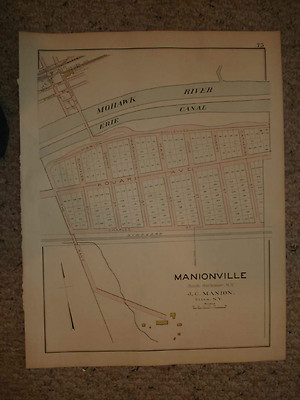
$3.75 Shipping Location: Winter Springs, United States Click Here. Double your traffic. Get Vendio Gallery- Now FREE! Vintage antique 1906 handcolored map. The map is 4 pages. And any side would frame and ... moredisplay nicely. The first page is Manionville, South Herkimer N.Y. The next 2 pages is a large and outstanding map titled Newport, and an inset map of Jordanville. The last page is Middleville, also a beautiful map. Beautiful map. This is an antique map and not a reprint or reproduction. I dont like or sell reproductions. The handcoloring on the map is period to the map, this is before color printing. The map is from the very rare 1906 New Century Atlas of Herkimer County New York. The map is a fascinating and historic period look at this area at this time. The map shows the home and land owners, the business and industry, the few roads, railroads etc that existed at that time. The photo wont show the full beauty of the map. The map is in nice shape and would frame and display quite beautifully. The size of the single page map is 21.5" by 17" and the double page map is 21.5" by 34" Winning bidder pays $3.75 shipping domestic, more foreign. Payment I accept the following forms of payment: PayPal, Preferred Checkout For fastest processing of this order. Please use Vendio Checkout! Shipping& Handling $3.75 USPS FREE image hosting(including supersized) with Vendio Sales Manager. Listing automation and FREE scheduled listings by Vendio. Win more auctions at the last minute FREE. Learn how.
Buy It Now
Free Shipping Location: Sielow, Germany They each bid on 1 card (according to Image original photo of the respective offer), shipping costs are calculated exclusively from the shipping weight ... morevia a special shipper for large piece goods. put something together in peace and quiet West German publishers mostly have wooden sticks, see partial item description, damage is also mentioned where possible, if the hadü suspension/fastening is needed, please if necessary. Please ask or let me know if necessary. I reserve the right to dismantle inadequate/wobbly hooks; what is not on it cannot be broken or interfere with transport, and I may have. a hook for free use Purpose: children's room, teenager's room, traditional room, men's room, classroom, hallway, auditorium, for information, discussion with children, students, travelers, parents,.
Buy It Now
$78.30 Shipping Location: Saarburg, Germany This old school wall map contains information in a style typical of the time. The roll card, formerly used in a school, is a beautiful collector's item. ... moreAll roll cards we offer are used and not new. Therefore, they have the usual signs of use and storage that occur at school. These include, for example: slightly yellowed, kinks, small paint chips, micro cracks, rope needs to be re-fixed, ... . - other shipping providers: In principle, shipping can take place with any desired provider that transports this package size. The costs are then calculated individually. However, prior agreement is then urgently necessary. However, we have included the most cost-effective transport offers. Our antiques and collectibles are usually subject to differential taxation in accordance with Section 25a UstG.
|
|
|
In
|
HUGE ANTIQUE 1918 PROVIDENCE RHODE ISLAND MAP ICE COMPANY MASHAPAUG POND RARE NR
Click Here. Double your traffic. Get Vendio Gallery- Now FREE! Rare. Large, superb, vintage 1918 handcolored linenbacked map. This is the finest antique map of this area I've ever seen! The map is titled Providence. The map shows Sherwood Ice Company, Mashapaug Pond, the home and land owners, size of buildings and homes, named period business and industry, named churches, named schools, named streets, named neighborhoods and additions, large named mansions, huge named business and industry, and much more. Many fascinating areas on the map. The map has some wear along the bottom middle fold. The linenbacking protect the map. This is a vintage antique fine handcolored map, printed on thick, beautiful paper. From the very rare 1918 Hopkins Atlas of Providence Rhode Island. In my opinion Hopkins was one of the premier mapmakers of this period. ... moreI've seen many great antique county and city maps, by great names like Beers, Bromley, Mueller, Caldwell and more, and Hopkins was one of the finest of this period. They used the best handcoloring, paper, typography, cartography and overall amazing detail. Its not a reproduction or copy. The map is an amazing and important historical snapshot of this area of Providence at this time. My photo wont show the full beauty of the map. The size is 22.5" by 31" great size. Winning bidder pays $4.25 shipping domestic,more foreign. Payment I accept the following forms of payment: PayPal Click to View Image Album Shipping& Handling US Shipping. $4.25 USPS First-Class Mail® International Shipping. $11.50 USPS First-Class Mail International FREE scheduling. Supersized images and templates. Get Vendio Sales Manager. FREE scheduling. Supersized images and templates. Get Vendio Sales Manager. RcmdId ViewItemDescV4,RlogId p4%60bo7%60jtb9%3Fuk.rp*05e54c%3E-148988a9025-0x115-
|
|
 |