-
Christian Collectibles
-
Christian Sheet Music
-
Vatican Stamps
-
Vatican Coins & Paper Money
-
Antiques
-
Antiquities
-
Architectural & Garden
-
Decorative Arts
-
Ethnographic
-
Furniture
-
Maps, Atlases & Globes
-
United States (Pre-1900)
-
United States (1900-Now)
-
AK, HI
-
AL, FL, GA, MS, NC, SC
-
AR, IA, KS, LA, MO, NE
-
AZ, CA, CO, NM, NV, UT
-
CT, MA, ME, NH, RI, VT
-
DC, DE, MD, NJ, NY, PA
-
ID, OR, WA
-
IL, IN, MI, OH, WI
-
MN, MT, ND, SD, WY
-
OK, TX
-
VA, WV, KY, TN
-
Entire US
-
United States (Date Unknown)
-
Africa
-
Asia
-
Australasia/ Oceania
-
Canada
-
Central America/ Caribbean
-
Europe
-
India
-
Ireland
-
Mexico
-
Middle East
-
North America
-
South America
-
United Kingdom
-
Maps on CD
-
World Maps
-
Globes
-
Mixed Lots
-
Reproductions
-
Price Guides & Publications
-
Other
|
In
Order by: Available to: This site contains affiliate links for which I may be compensated
|
Free Shipping Location: Schertz, United States This antique map is of New England, specifically ME, NH, VT, MA, CT, and RI, as well as Boston and New Haven. Created in 1839 by Thomas, Cowperthwait ... more& Co.. The map is hand-colored and depicts the area during the Victorian era. The book cover is not available and is shown for reference only. Free shipping is offered within the USA, while shipping worldwide is calculated.
Buy It Now
$14.60 Shipping Location: Monroeville, United States Principal Towns - North Adams, Adams, Cheshire, Berkshire, Williamstown. Date of Published - 1890, surveyed 1885. Source - Topographical Atlas of Massachusetts. ... moreBodies of Water - Berkshire Reservoir, Greenfield River.
$7.00 Shipping Location: North Wales, United States 1874 MITCHELL'S NEW GEOGRAPHY MAP-NEW ENGLAND STATES-ME, MA, CT, RI-HAND COLORED ORIGINAL ANTIQUE ATLAS MAP PLEASE SEE PHOTOS AS PART OF THE DESCRIPTION ... moreCONDITION: MAP IS IN GOOD CONDITION. SIZE: APPROXIMATELY 14" X 21" SHIPPING: U.S. FIRST CLASS RATE - $7.00 - ANY ITEM WHICH SELLS FOR OVER $100 WILL REQUIRE INSURANCE WE COMBINE SHIPPING FOR MULTIPLE WINS. THANK YOU FOR YOUR INTEREST IN OUR AUCTIONS!.
Buy It Now
$4.13 Shipping Location: Palm Beach, United States USGS TOPOGRAPHIC MAP - WEBSTER, MASSACHUSETTS / CONNECTICUT / RHODE ISLAND. The reverse has explanation of topographic features and a legend of map symbols. ... moreMap Series: 15 minute.
Buy It Now
$6.00 Shipping Location: Arlington, United States THIS MAY HAVE BELONGED TO THE PERSON WHO DID THE MAP ORIGINALY AND IT'S HAND MARKED IN SPOTS.
Buy It Now
Free Shipping Location: Anaheim, United States Typically that map at hand, the one being looked at, is in the center box. Scale: 1:100,000 (100K). Woodland areas. feature within the bounds of the map, ... morewhich frequently is a community, town, or city.
Buy It Now
$14.60 Shipping Location: Monroeville, United States Principal Towns - Monterey, Tyringham, East Otis, New Boston, Montville, South sAndisfield, New Marlborough. Date of Published - 1890, surveyed 1886. ... moreCondition - Rather Nice, lower right corner crease reinforced on back with neutral archival tape, 2" tear up from bottom also repaired on reverse, blank border chunk missing on left edge.
Buy It Now
$4.15 Shipping Location: Saco, United States The Atlas was published in 1865 by Augustus Mitchell Jr and this map was first published in 1860 as shown on the bottom left. Wonderful Color and Detail ... morefor a Civil War Year Map. I will also include a copy of the Title Page.
Buy It Now
$4.13 Shipping Location: Columbia, United States Antique original from 1866 Grammar School Geography Book. Hand-Colored Map of"United States No. 2".
Buy It Now
$4.95 Shipping Location: Bar Harbor, United States This treaty awarded 7,015 square miles to the United States and 5,012 square miles. Scarce ©1839 Mitchell Map №6. The dispute festered and smoldered until ... more1839, when it threatened to erupt into open warfare.
Buy It Now
$6.49 Shipping Location: Santa Monica, United States “Map of New England and New York To Illustrate Olney’s School Geography.”. Condition – approx. A portion of Maine is cut off at the top.

Buy It Now
$6.50 Shipping Location: Ellsworth, United States eBay Template MBS Item No: SJ1978 Item Condition Guide Notice: This guide is solely for the purpose of explaining how we rate conditions and is not relative ... moreto this current item's condition. The items condition is listed under the"Description" section of this template. Mint Item is like-new condition with minimal defects or wear. Excellent May have some very minor wear. Nicks, or dents. Overall the item is nearly like-new but may have some manufacturing flaws. Very Good Item shows signs of wear and tear or minor damage. Good Lots of wear and defects due to use and handling of the item over the years. May look or work as intended apart from defects. Fair The"acceptable" condition. Items ranked at this are typically in states of disrepair. Wear, or missing parts or features. Poor These items show massive amounts of wear. Damage, or missing parts. Typically they are non-repairable and non-working. Contact Us. Feedback. Profile. More Auctions. ORIGINAL 1883 Cram Atlas Map MA. CT, RI, NH, VT 5 States Hand Colored Description. Vermont& New Hampshire on one side. Massachusetts, Connecticut, Rhode Island on the reverse. Measures 13 ¾ x 11 1/2” Map from an 1883 Cram Atlas. Near-Excellent Condition. Payments. PayPal® is our preferred payment method but we will also accept debit or credit cards via PayPal®. We do not accept personal or business checks under any circumstances. For other payment methods. Please contact us before any bidding activity or using the Buy-it-Now feature. Payment must be made within 5 days or an unpaid item case will be opened. After 10 days from the auction end date if no payment or contact has been made. The case will be closed and transaction canceled. Invoices are sent out within one hour for items to be combined shipped after each nights auctions have ended. Please do not pay for items until you recieve a combined invoice with the adjusted shipping rates. Shipping refunds will not be given for payments made before these invoices are sent out. Returns.
Buy It Now
$8.00 Shipping Location: Charlton City, United States THE NEW ENGLAND COMMERCIAL ROUTE SURVEY MAP NH VT ME MA CT 1914. THE MAP IS APPROX 3 FEET 6 INCHES WIDE AND APPROX 4 FEET IN HEIGHT. THIS MAP IS VINTAGE ... moreORIGINAL COPY RIGHTED IN 1914 BY THE BULLARD CO. BOSTON MASS. AS YO CAN SEE THERE ARE SOME TEARS IN THE SEAM A EASY REPAIR BUT I AM NOT A EXPERT I WILL LEAVE THAT TO YOU. SOLD AS IS YOU WILL HAVE TO DETERMINE THE GRADE AND CONDITION. THERE IS A INDEX ON THE REVERSE IN REGARDS TO POPULATION. DISTANCE TABLE. STORED IN CLEAR TOTE GARAGE TOTE 98
Buy It Now
$9.00 Shipping Location: Somerville, United States They are from the estate of George Porter, who was a sales executive for Hoover Vacuum Cleaners in the Northeast Region. Porter was a WWI vet so he likely ... moreworked for Hoover until the late 1950's or early 1960's.
Buy It Now
$11.85 Shipping Location: Dover, United States The Tarbell-Watters Co. Inc., Wholesale Distributers of Motor Car Necessities, 1926. Issued between 1899 and 1930. All are attractive and well-preserved ... moreexamples. Short video captures condition much better than words.
Buy It Now
$8.85 Shipping Location: Mount Washington, United States Ent er litit l st here Enter listing title here Enter listing title here Enter listing title here Enter listing title here Enter listi title here Dimensions: ... more8 x 11 1/2 Enter listing title here Enter title list herDimensions : No Reasonable Offer Refused SKU 751.
Buy It Now
$6.15 Shipping Location: Bar Harbor, United States 1886 Original Antique Mitchell Map. Mitchell's Modern Atlas. New Jersey, New York, Pennsylvania & Delaware.
Buy It Now
$4.75 Shipping Location: Wortham, United States ORIGINAL 1874.
Buy It Now
$5.85 Shipping Location: Cumby, United States Vintage Gulf Tourgide Map- 1950s GULF Map- NH/VT/MA/CT/RI. See all photos - there are small holes in the folds and some discoloration. LR
Buy It Now
$12.45 Shipping Location: Radford, United States It has a few spots mostly in the margins but looks great! Has a couple tears in the margins.
Buy It Now
Free Shipping Location: Anaheim, United States Typically that map at hand, the one being looked at, is in the center box. feature within the bounds of the map, which frequently is a community, town, ... moreor city. The map covers a specific amount of area.
Buy It Now
$6.05 Shipping Location: Merrimack, United States Condition shown in photos
Buy It Now
$4.95 Shipping Location: Bar Harbor, United States 1835 Smith Map. Smith's Atlas. by Roswell C. Smith. Eastern States. An exceptional addition to any map collection. antique display. The Aroostook War ... morewas a military and civilian-involved confrontation in 1838–1839 between the United States and the Britain over the international boundary between the British colony of New Brunswick and the U.S. state of Maine.
Buy It Now
$10.00 Shipping Location: Winston Salem, United States
Buy It Now
$7.00 Shipping Location: Jacksonville, United States A very attractive depiction.
Buy It Now
$4.13 Shipping Location: Palm Beach, United States The reverse has explanation of topographic features and a legend of map symbols. Map Series: 1 - 5 minute. Condition: Graphic area is excellent, no foxing ... moreor toning on the map, the border condition is very good/excellent, with a corner having a short crease.
Buy It Now
$2.00 Shipping Location: Concord, United States RARE* GULF INFO- MAP 1940'S-ERA Front has picture of a Gulf lamp-post and sign with a classic car in background. Back has a picture of"YOUR GOOD ... moreGULF DEALER" and an example of the"jiffy" service you used to get back in the day(full-serve. Air-pressure check, etc. Interior of Map has on on each side a map explanation. An index of towns, and facts on the states on that side of the map. The facts are based on 1944 estimates. Also included are motor laws for each state. Dimensions/Color: white background. Folded: 9" x 4" See listing for condition; sold as is. No returns. Ask questions before bidding/buying. Will combine shipping. If via bid. Please advise and I will invoice combined shipping. If via"Buy-it-Now" I will refund any excess after handling,etc. See my other auction for other similar interesting items.
Buy It Now
Free Shipping Location: Bonita Springs, United States Be sure to add me to your! This is an original. Not reproduction, vintage map of the Caribbean, West Indies, which was carefully removed from an atlas. ... moreThere is surrounding border and index beyond the map. This map measures approximately 9" by 12.5" and is in very good condition. Your item will be packaged in a plastic sleeve. With a thin piece of backing, then in a manila envelope with a very stiff and thick piece of cardboard or in a cardboard mailing tube. We happily combine purchases to save on shipping fees. Please email with questions. We will answer your email promptly! Please visit our ebay store. Plaindealing Vintage Paper. We have stocked it with thousands of vintage advertisements, prints, and historical articles. Check out my! Powered by The free listing tool. List your items fast and easy and manage your active items.
Buy It Now
$3.50 Shipping Location: Bar Harbor, United States Harbors and Vicinity. Born in Connecticut he worked as a geography teacher but soon realizing there were only poor quality geographical resources available ... moreto teachers he turned to publishing. It becoming one of the leading map and atlas publishers of the nineteenth century.
Buy It Now
$4.13 Shipping Location: Palm Beach, United States Map Series: 15 minute. Map is an antique original, not a reproduction. Condition: Very Good, minimal foxing along portions of right side common to graphic ... morearea/border, toning appropriate for a 113-year-old map, border is intact.
Buy It Now
$4.13 Shipping Location: Camden, United States
Buy It Now
$4.13 Shipping Location: Palm Beach, United States Reverse side has explanation of topographic features and legend of map symbols. Map Series: 15 minute. Map is an antique original, not a reproduction. ... moreCondition: Very Good, no foxing, toning appropriate for a 114-year-old map, border is intact except for a very minor portion of a corner missing.
Buy It Now
$4.13 Shipping Location: Palm Beach, United States The reverse has explanation of topographic features and a legend of map symbols. Map Series: 15 minute. Significant waterbodies exist throughout the map ... morearea, including the Lakes of Mahopac, Peach, Gilead, Glenida, and Waccabuc, the Reservoirs of West Branch, Middle Brook, East Branch, Bog Brook, Titicus, Muscoot, and Boyd Corners, and the Rivers of Croton, Middle Branch Croton, West Branch Croton, and East Branch Croton.
Buy It Now
$5.95 Shipping Location: El Prado, United States This map is on book plate paper and is foxing/tanning due to age. There are no tears present that we can find. Up for sale is an antique map of the states ... moreof Massachusetts, Rhode Island, and Connecticut from the 1887 publication of.
Buy It Now
Free Shipping Location: Anaheim, United States One Paper State Highway Map. Map Publisher: RAND-McNALLY. Map is folded. Springfield, MA. Mileage Log. Places of Interest. State Park Charts. State Indexes.
Buy It Now
$15.45 Shipping Location: Palmyra, United States The inner part of the matting measures about 17.25" x 11.25". The outer measurements are about 16.5" x 22.75". The map is attached only at the top.
Buy It Now
Free Shipping Location: Monroeville, United States Date - 1898. Condition - Very Nice.
Buy It Now
$4.13 Shipping Location: Palm Beach, United States Reverse has explanation of topographic features and a legend of map symbols. Map Series: 15 minute. Condition: Very Good, no foxing, toning appropriate ... morefor a 116-year-old map, border is intact.
Buy It Now
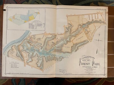
$15.00 Shipping Location: Orange, United States Normal 0 false false false EN-US JA X-NONE 1899 Antique Atlas Hand Colored Topographical Map Forest Park Springfield MA Removed from an 1899 City of Springfield ... moreMA Atlas Published in Springfield. MA by J L Richards. Printed on lightly coated period linen( backed paper as issued which retains its inherent structural flexibility and soundness; has detailed park features such as Pecousic Villa(Everett Barney’s home) King Phillips Indian Stockade, Aquatic Gardens, Lotus Pond, Skating Pond, The Playground, Deer Preserve, Swan Pond, Children’s Paddle Pond, Bear Pit, Menagerie Building, the mysterious“Dean Massacre” site, etc. Shows original road network(now substantially changed) shows location of the Pecousic railroad station where day visitors got on and off the train. Shows the sources of the park land by gift and purchase including land from famous local families: Barney. Chapin, Southworth, McKnight, Wesson, Merriam, and Stebbins Most individual buildings then existing are clearly visible as structures; old(and many now changed) street names are shown This scarce old map has been nicely beautifully printed and lithohraphed on an oversized folio sheet. Allowing for a reliable and precise detailed rendering In VERY GOOD/ EXCELLENT condition: displays normal minor light age toning. Staining or foxing; overall the map remains very clean and very displayable. Please note: the lighting for the photos is terrible. The photos make this look there is lots of staining. Especially down the centerline fold but that is not the case. This displays beautifully in person. Note the zoom feature which allows for very close inspection. Minor defects along the sheet edges and corners do not detract. Super old printed paper map entirely worthy of any collection and/ or display. A cartographic depiction captured in a manner entirely unique to this particular historical era. Not only is the artistic style interesting. But the historical method used for printing it essentially no longer exists. This renders the sheet of pape
Buy It Now
$6.00 Shipping Location: Arlington, United States
Buy It Now
$5.10 Shipping Location: Saco, United States Nautical Chart for the Eastern Part of Long Island Sound. Milford, CT to New London, CT is the Coastline Shown. One round stain on the rightside border. ... moreCut down from a large map.
Buy It Now
$4.00 Shipping Location: Columbus, United States This map is in Very Good condition, with nice bright color. HOFFMAN BOOKS, ABAA, IOBA.
Buy It Now
$14.60 Shipping Location: Monroeville, United States Date of Published - 1890, surveyed 1886. Condition - Rather Nice, several creases in top blank border reinforced on reverse by neutral archival tape. ... moreBodies of Water - Springfield Seservoir, Chicopee River, Swift River.
Buy It Now
$2.75 Shipping Location: Amherst, United States U.S.G.S. TOPOGRAPHICAL MAP. DURHAM QUADRANGLE. Map shows portions of the towns of:Durham. Madison, Guilford, Killingworth. Circa 1953. A rather scarce ... moremap, it will make a nice gift or addition to your collection.
Buy It Now
Free Shipping Location: Monroeville, United States Date - 1860. Condition - Nice, but an extra top-to-bottom fold near the double page fold. Publisher - Mitchell.
Buy It Now
$4.50 Shipping Location: Minneapolis, United States
Buy It Now
$6.35 Shipping Location: Hanover, United States This is an original 1875 Map of Middlesex County Mass. published by Beers Atlas.The reverse side shows a half page map of Massachusetts, Rhode Island ... moreand Connecticut.This is an original and not a reproduction.The map measures approx 24” x 15.5”.It is in excellent condition with original hand coloring. The map will be shipped flat to prevent damage or wrinkles.Please see our other listings for additional maps.
Buy It Now
$4.13 Shipping Location: Palm Beach, United States Reverse has explanation of topographic features and a legend of map symbols. Map Series: 15 minute. Condition: Very Good, no foxing, toning appropriate ... morefor a 114-year-old map, border has minor fraying.
Buy It Now
$4.13 Shipping Location: Palm Beach, United States The reverse has explanation of topographic features and a legend of map symbols. Map Series: 15 minute.
Buy It Now
$4.40 Shipping Location: Saco, United States This 2 Page Map will have Connecticut and Rhode Island on the Reverse Side. Harvested from an 1890 Rand McNally New Family Atlas as shown in last photo. ... moreCurrently 21 3/4" x 14 1/8". Wonderful Gift for the person that has everything.
Buy It Now
$16.23 Shipping Location: Natick, United States catalog and index for topocgraphic maps
Buy It Now
$4.13 Shipping Location: Palm Beach, United States Type Map: Topographic. Reverse has a legend of map symbols and explanation of topographic features. Map Series: 15 minute. Condition: Very Good, no foxing, ... moretoning appropriate for a 115-year-old map, border has minor fraying.
Buy It Now
Free Shipping Location: Anaheim, United States Typically that map at hand, the one being looked at, is in the center box. Scale: 1:100,000 (100K). Rhode Island - Connecticut - New York - Massachusetts. ... moreWoodland areas. feature within the bounds of the map, which frequently is a community, town, or city.
Buy It Now
$4.13 Shipping Location: Palm Beach, United States Adjoins the Northampton USGS map to the north. The reverse has explanation of topographic features and a legend of map symbols. Map Series: 15 minute. ... moreCondition: Graphic area is excellent, no foxing or toning on the map, the border condition is very good with very limited fraying at the edges.
Buy It Now
$4.13 Shipping Location: Palm Beach, United States Type Map: Topographic. Reverse side has explanation of topographic features and legend of map symbols. See details map photos of harbors. Printing Technique: ... moreCopper plate Map Series: 15 minute.
Buy It Now
Free Shipping Location: Stevens Point, United States I have for sale one 1883 New England Map, MA, CT, and RI Cram's Unrivaled Family Atlas of the World.
Buy It Now
$4.13 Shipping Location: Palm Beach, United States Adjoins the Springfield USGS map to the south. The reverse has explanation of topographic features and a legend of map symbols. Map Series: 1 - 5 minute. ... moreCondition: Graphic area is excellent, no foxing or toning on the map, the border condition is good with a corner having crease and fraying at the edges.
Buy It Now
$7.00 Shipping Location: Jacksonville, United States A beautiful and vibrantly colored map from the 1860 2nd edition Mitchell New General Atlas, the map was originally entered in to Congress in 1860.

Buy It Now
$3.95 Shipping Location: Clarkston, United States Rare Map Collection This DVD is part of our Historic Map and Atlas Collection. We have dozens of Atlas maps on DVD and CD ranging from the 1500s to the ... more1900s covering many areas and topics. Please Check our Ebay Store for what's available. FOR MANY MORE EDUCATIONAL CD TITLES ON THIS AND MANY OTHER SUBJECTS PLEASE VISIT OUR EBAY STORE VERY LARGE HIGH RESOLUTION MAP COLLECTION ON DVD! please see full table of contents and sample illustrations below) This DVD Contains 210 Maps of Florida Including 13 PANORAMIC MAPS of various Florida Cities These are scans of the ORIGINAL maps by various Cartographers. on DVD System requirements PC or Mac compatible. Files are simple PDF files with a basic HTML interface(just like viewing a webpage) Works with ALL versions of Windows. Maps of Florida 0041011 Florida Asher& Adams 1874, 0089031 Florida Bradford. Thomas G. 1838, 0104008 Florida Burr. David H 1839, 0122032 Florida Carey. H. C 1822, 0149036 Florida Colton. G.W. 1856, 0278013 Florida Finley. Anthony 1826, 0285031 Florida Finley. Anthony 1831, 0346029 Coast Of West Florida and Louisiana.with the Bahama Islands. Jefferys. Thomas 1776, 0537022 Florida Mitchell. Samuel Augustus 1845, 0565018 County Map Of Florida. Mitchell. Samuel Augustus 1860, 0586026 Florida. Mobile Mitchell. Samuel Augustus 1880, 0594027 Florida Mitchell. Samuel Augustus 1890, 0632022 East and West Florida Morse. Jedidiah 1794, 0890141 Florida Society for the Diffusion of Useful Knowledge(Great Britain) 1834, 0977018 Florida Tanner. Henry S. 1836, 1070014 Florida U.S. General Land Office 1866, 1780149 Florida. Gen. map XI Julius Bien& Co. United States. War Department 1895, 1780150 Florida. Gen. map XII Julius Bien& Co. United States. War Department 1895, 2209000 Map Of The Seat Of War In Florida Hood. Washington 1838, 2212268 Florides et Iles Lucayes Vandermaelen. Philippe 1827, 2239030 Florida. Georgia, and South Carolina Lloyd. H. H. 1873, 2301031 Florida Morse. Sidney Edwards) Breese, Samuel 1845, 2329007 Floride. Delta du Mississippi

Buy It Now
$3.50 Shipping Location: Clarkston, United States Rare Map Collection This DVD is part of our Historic Map and Atlas Collection. We have dozens of Atlas maps on DVD and CD ranging from the 1500s to the ... more1900s covering many areas and topics. Please Check our Ebay Store for what's available. FOR MANY MORE EDUCATIONAL CD TITLES ON THIS AND MANY OTHER SUBJECTS PLEASE VISIT OUR EBAY STORE VERY LARGE HIGH RESOLUTION MAP COLLECTION ON DVD! please see full table of contents and sample illustrations below) This DVD Contains 140 Maps of West Virginia Including 29 PANORAMIC MAPS of various West Virginia Cities These are scans of the ORIGINAL maps by various Cartographers. on DVD System requirements PC or Mac compatible. Files are simple PDF files with a basic HTML interface(just like viewing a webpage) Works with ALL versions of Windows. Maps of West Virginia 3565087 Rand McNally and Company Date: 1897 Short Title: West Virginia. 4190000 Richardson. C.S. Date: 1864 Short Title: Richardson's Map Of West Virginia. 4975106 Hayes. Eli L. Date: 1877 Short Title: Point Pleasant. Mason Co. West Va. with) West Columbia, Clifton, W. Va. 4975111 Hayes. Eli L. Date: 1877 Short Title: Huntington. Cabell Co. W. Va. 4975113 Hayes. Eli L. Date: 1877 Short Title: Ceredo. Wayne Co. 1st Dist. W. Va. with) Catlettsburg, Boyd Co. Ky. ar300700 Washington. George, 1732-1799. Main Title: Plat of a survey for William Hughes. Jr. of 460 acres in Frederick County, Va. on the Cacapon River] 1750. ct000363 Washington. George, 1732-1799. Main Title: Eight survey tracts along the Kanawha River. W.Va. showing land granted to George Washington and others. 1774? ct000592 West Virginia Geological Survey. Main Title: Soil map: West Virginia. Boone county sheet. Baltimore: A. Hoen& Co. 1913. ct000593 Swann. John S. Main Title: Title map of the coal field of the great Kanawha Valley. New York: G.W. C.B. Colton. 1867. ct000594 Hotchkiss. Jedediah, 1828-1899. Main Title: Map of Great Kanawha coal field showing location of mines. Staunton. Va. 1886. ct000595 Chesapeake and Ohio Railroad C
|
|
|
In
|
OLD VINTAGE MAP 1955 NEW ENGLAND STATES ME NH VT MA CT RI 29 X 43 #7
THIS IS#7 OF 20 OLD VINTAGE MAPS I AM LISTING SEPERATELY PURCHASED FROM THE SAME ESTATE. THIS IS A MAP OF NEW ENGLAND COPYRIGHT 1955.LITHOGRAPHED FOR THE NATIONAL GEOGRAPHIC MAGAZINE.THESE MAPS HAVE ALL BEEN STORED FOLDED AND SHOW SIGNS OF VINTAGE WEAR. THEY ARE CREASED AT THE FOLDS WITH SOME SPLITS WHERE THE FOLDS COME TO CORNERS. EDGES ARE FRAYED AND TORN IN SOME AS WELL.THIS ONE IS IN PRETTY NICE CONDITION. PLEASE SEE PICTURES FOR GRADING AS I AM NOT AN EXPERT ON THESE. THE MAP SHOULD BE FRAMED IN ORDER TO PROTECT IT BETTER AND TO HELP SMOOTH OUT THE FOLDS. THESE WILL LOOK ABSOLUTELY COOL IN A FRAME ON THE WALL AND ARE AUTHENTIC VINTAGE MAPS. ALL MAPS ARE BEING SOLD AS IS SEEN IN THE PICTURES.I AM SHIPPING THEM IN FLAT RATE BOXES FOR $10.95 IN ORDER TO NOT CRUSH THEM AND TO ENSURE THEY ARRIVE IN THE CONDITION THEY LEAVE ME.COMBINED SHIPPING ... moreWILL BE AVAILABLE: ENJOY!
|
|
|
Antique CITY OF SPRINGFIELD, MA., & HARTFORD, CT. Maps, c1929
Our auctions feature a Low Starting Bid. And Never a Reserve. We also offer reduced shipping costs on multiple purchases where common packaging is possible- take advantage of that by previewing our many auctions each week. 12Jan06P) Our packaging is as professional as professional gets- we've wrapped thousands of items and receive so many fine compliments from our buyers in that regard. WE OFFER AN EBAY STORE AS WELL! Low Opening bid. And No Reserve! Shipping& Handling is additional. Shipment is quoted via USPS. Larger items over 108" shipped via other methods such as UPS. Larger Furniture Items by various means including Greyhound where packaging the item is possible, or via freight carrier. FOREIGN BUYERS SEE BELOW. Use The SHIPPING CALCULATOR on this listing to get your Exact Shipping& Handling Costs. We ship via USPS. ... moreExcept for extra large items(over 108 inches combined length and girth) If the item's value is over $250.00, the package will be sent with a"Signature Confirmation" which will be required when delivered. If the package is extremely large or fragile we will ship via other means upon arrangements with the buyer. Outside the U.S. Payment& Shipping Details: If you are a foreign buyer. All purchases above $100 will require Express Mail Service(Express Mail Service via the USPS) so that we can add a Signature Confirmation on the package. Any package which does not arrive after 30 days we will then be able to apply for insurance payment. Other forms of USPS shipment other than Express Mail can take up to 3 weeks for delivery. WE WILL SEND AN EMAIL INVOICE AT THE CLOSE OF THE AUCTION FOR YOU TO MAKE PAYMENT. BUYERS.KEEP IT SIMPLE- Did you know you can bid once. At any time during the auction- that you need not wait until the end of an auction to bid. Just put in a bid for the most you're willing to pay for an item, and relax. Other bidders may bid but the price you pay only goes up by one increment at a time. You can bid up to $20 but if nobody else bids and the op
|
|
|
Antique 1910 Census Pocket Map MA CT RI Railroad Congressional District Hammonds
Antique 1910 Census Pocket Map MA CT RI Railroad Congressional District Hammonds Click to Enlarge Click to Enlarge Click to Enlarge Click to Enlarge 0-0 Southern New England census pocket map from 1910 Shows railroads. Steamboat lines and congressional districts of Massachusetts, Connecticut and Rhode Island Measures 3 1/2" left to right x 7 1/2" top to bottom when closed Measures 22" left to right x 14" top to bottom when folded out Nice condition no rips. No tears, corners slightly rounded, no foxing, no writing, slight yellowing on map, red congressional lines on map show through to other side I have other items. To view them. Use the store search box, remember I combine shipping to save on shipping! Shipping Packages insured with delivery confirmation, Purchases shipped within 1 day of cleared payment weekdays(except ... moreholidays) Quality packing with care and expertise, Combined shipping from $2.00 to $3.00 each additional item- depends on size/weight Shipping discount only reflected on adjusted invoice. You must wait for adjusted invoice before paying- we are unable to give refunds if payment's made before adjusted invoice if you have any questions or want combined shipping estimates, PA sales tax automatically added on all orders shipped to Pennsylvania, More detailed information on shipping policies International Customers Please Note: Customs forms filled out with declared value as the amount you paid for your purchase Import duties. Taxes and charges are not included in the item price or shipping charges. These charges are the buyer's responsibility Please check with your country's customs office to determine what these additional costs will be prior to bidding/buying, More detailed information on international shipping policies inkfrog terapeak. I000000. Analyzing"Smart Counters" only at inkFrog ShipSaver.
|
|
|
Old Vintage Map Massachusetts MA Southwick /Connecticut CT
Old Vintage Map Massachusetts MA Southwick/Connecticut CT Large size: map image is about 13" inches by 18" inches plus border margins. ``d.RcmdId ViewItemDescV4,RlogId p4%60bo7%60jtb9%3Fvo%7B%3Dd70f%2B%3E%60%60d-13f45398cb7-0x104-
|
|
|
Old Vintage Map Massachusetts MA Monson /Connecticut CT
Old Vintage Map Massachusetts MA Monson/Connecticut CT Large size: map image is about 13" inches by 18" inches plus border margins.
|
|
|
Old Vintage Map Massachusetts MA Springfield South /Connecticut CT
Old Vintage Map Massachusetts MA Springfield South/Connecticut CT Large size: map image is about 13" inches by 18" inches plus border margins. RcmdId ViewItemDescV4,RlogId p4%60bo7%60jtb9%3Fuk.rp*4a24%60%3C%3E-13f45398d43-0xf4-
|
|
|
Old Vintage Map Massachusetts MA Southbridge /Connecticut CT
Old Vintage Map Massachusetts MA Southbridge/Connecticut CT Large size: map image is about 13" inches by 18" inches plus border margins.
|
|
|
Old Vintage Map Massachusetts MA Hampden /Connecticut CT
Old Vintage Map Massachusetts MA Hampden/Connecticut CT Large size: map image is about 13" inches by 18" inches plus border margins.
|
|
|
Old Vintage Map Massachusetts MA West Springfield /Connecticut CT
Old Vintage Map Massachusetts MA West Springfield/Connecticut CT Large size: map image is about 13" inches by 18" inches plus border margins.
|
|
|
Old Vintage Map Massachusetts MA Sheffield /Connecticut CT/New York NY
Old Vintage Map Massachusetts MA Sheffield/Connecticut CT/New York NY Large size: map image is about 13" inches by 18" inches plus border margins.
|
|
|
1962 Hartford CT USGS Topo Map Topographical NK 18-9 NY NJ MA
USGS Topo Map NK 18-9 Hartford CT Map states“1962 Revised 1969” This is a local estate find and has been stored folded in a box for who knows how many years! The many points of interest and geographical details make the map fascinating to look at. The map is in color and the picture is of the actual map you are bidding on. Cities on the map are: Hartford. New London, New Britian, Bristol, Norwich, Milford, Stratford, Bridgeport, Fairfield, Norwalk, White Plains, Poughkeepsie, Danbury, Waterburry, Torrington Key points of interest on the map are: Long Island Sound. Portion of Long Island, Hudson River, Map is approximately 22” x 31 1/2” Shipping in the 48 states only via USPS First Class Mail. PayPal payments only with payment due 3 days after auction end. Questions are welcome and THANKS for looking.
|
|
|
Vintage 1950s New England Road Map - Tour with Texaco - CT, MA, RH, ME, NH, VT
Vintage 1950s New England Road Map- Tour with Texaco- CT. MA, RH, ME, NH, VT Click Images to Enlarge Vintage 1950s New England Road Map- Tour with Texaco- CT. MA, RH, ME, NH, VT Vintage 1950s New England states road map. Produced by Rand-McNally. Folded size: 4 x 8 inches VG Condition. Light general wear. Clean. No tears noted. We accept PayPal Only CANADA(Canada Post Lettermail) $2.30 USD UNITED STATES(Canada Post USA Lettermail) $2.95 USD INTERNATIONAL(Canada Post Int'l Lettermail) $4.75 USD To save you costs we are happy to combine shipping and handling on multiple items won or purchased to reduce costs. Shipping rates vary depending on the number of auctions won. Or items purchased, affecting the weight and size of the envelope. If you win multiple auctions, or have purchased several items, please wait for us to send a final invoice. ... moreWe ship your purchase(s) generally the next business day after receiving payment and no later than 3 business days after payment received. You will receive a notification of the date we ship your item(s) to you. We do not have any control. And therefore cannot be held responsible for the time it takes to get to you once we put it in the mail. If you would like to have your purchase(s) registered. Tracked, insured or shipped other than standard post, please let us know and we would be pleased to accommodate your request and advise you of the additional costs in doing so. All regular letter standard size mail from Canada is considered first class by Canada Post and sent by air. Items larger than this are sent by ExpressPost or parcel post in Canada; and Small Packet(Air) outside of Canada. We make every attempt to describe our items as best as possible and provide detailed photos. Email us at any time with your questions! inkfrog terapeak. I000000. Analyzing"Smart Counters" only at inkFrog inkFrog Analytics. 1.RcmdId ViewItemDescV4,RlogId p4%60bo7%60jtb9%3Fuk.rp73%28b0g%60%60%3E1-1418d2ed03b-0xe7-
|
|
|
Midget Road Maps ME MA CT RI VT NH New England 3 maps w/ leather case * minature
This is a group of three"Midget Road Maps" with their original leather carrying case. The maps cover Maine; Massachusetts Connecticut and Rhode Island; and Vermont and New Hampshire. There is no date but we would estimate them to be from the early 1900s. They are copyrighted by Clason Map. Folded up they are approx 3 1/2" X 2 1/4" but unfold to a good readable size. Maine. For example, is 16" X 12" when open. VT/ NH is missing the outer card covers. Otherwise condition is very good with just minor wear& a couple small tears. The leather case is in very good condition and the snap is in working order. P lease take a look at my other auctions; I do combine items when shipping. Thank you!
|
|
|
1931 Map: Canaan Stockbridge Sheffield Colebrook, Housatonic Quadrangle MA CT NY
1931 Large Original Antique Topographic Map:Canaan Stockbridge Sheffield Colebrook. Etc. Housatonic Quadrangle, New York NY Printed by the United States Geological Survey. Surveyed in 1884-1886& 1888. Edition of Nov 1900. Reprinted 1931. Dated on map. Title: Housatonic Quadrangle. Scale: 1:125.000. Size: Approx 20 x 16.5 inches. ENTIRE SHEET) Condition: Overall the condition is Very Good. Image area is Near Fine. Margins show signs of handling and wear(Some rippling at left edge where map was bound into portfolio. SEE PHOTOS. Please view the photos to make your own assessment. An excellent& early topographical wall map. Published in 1931, for display& framing. Returns: Any item may be returned for a refund. Please contact us within 14 days of receipt of your item if you feel an error has been made. We do not deal in modern reproductions. ... moreAll of our maps are original and authentic. Please browse other maps at our store. inkfrog terapeak. I000000.
|
|
|
1923 RAND MCNALLY AUTO TRAILS NEW ENGLAND #6 BOOKLET + MAP MA NH ME CT RI VT NY
A 1923 RAND MCNALLY AUTO TRAILS NEW ENGLAND#6 BOOKLET + MAP. 77 PAGES PLUS LARGE PULL OUT MAP. THE PAGES ARE FREE OF RIPS. TEARS, WRITING + WATER DAMAGE. COVER + FIRST PAGE HAVE LIGHT STAINING-MINOR. THE MAP IS IN GREAT SHAPE-CRISP + CLEAN. NICE VINTAGE 1923 BOOKLET WITH MAP. ANY QUESTIONS PLEASE EMAIL. $3.00 SHIPPING WITHIN CONT USA. THANK YOU! RcmdId ViewItemDescV4,RlogId p4%60bo7%60jtb9%3Fuk.rp*4a24%60%3C%3E-145b59ed629-0xf8-
|
|
|
1901 Roll Up Map SOUTH NEW ENGLAND Ma Ct RI Railroad PO COLOR
1901 Roll Up Map SOUTH NEW ENGLAND Ma Ct RI Railroad PO COLOR Paypal is prefered form of payment. We allow 3 days for payment unless otherwise agreed upon. After that. We reserve the right to relist the item and file a non payment claim with ebay. Free shipping on items which is listed as"free shipping" is for the US only. We may be able to negotiate a shipping discount for international buyers. Please contact us. We ship very fast. Usually within 1 business days after payment is received. We"pad like mad" We do not skimp on any packing material including bubble wrap, peanuts, styrofoam, double boxing etc. Every attempt is made to ensure safe delivery of your item. Tracking information can always be located below the item after it is shipped. If an item arrives damaged. Please contact us prior to leaving feedback. International ... moreBuyers: Please Note: Import duties. Taxes, and charges are not included in the item price or shipping cost. These charges are the buyer's responsibility. Please check with your country's customs office to determine what these additional costs will be prior to bidding or buying. We will not mark items as"Gift" or reduce the customs values. Please do not even ask. This is merchandise regardless if you are giving it as a gift. Size and weights limits differ from country to country. Please contact us prior to bidding on large items so that we can be sure it can be shipped. Always happy to ship to a US global shipping facility. Import regulations differ from country to country. Please be sure any item we are selling is not restricted from your country. WE DO NOT SELL/ SHIP TO RUSSIA! Unless otherwise noted in the listing. Returns are accepted within 14 days if item is not as described. We will always work with a buyer to ensure a happy transaction. Please contact us prior to leaving any neutral or negative feedback. We are Tim and Wendy Ingersoll. Partners in life. We enjoy enriching our relationship through socializing with friends and family and participa
|
|
|
RARE Antique Automotive GULF ROAD MAP - for MA., CT. & RI. for 1933 Auto Travel
RARE Antique Automotive GULF ROAD MAP- for MA. CT. RI. for 1933 Auto Travel. Beautiful Clean condition with great graphics of the Cars, early Gulf Refining Company Gas Pumps, etc. This is only one of thousands of collectible paper and postcards we currently have listed at auction and in our store! Check out all our listings to find what you're looking for. Join our thousands of satisfied customers- place a bid and capture a piece of history you'll treasure. 14Aug07PA) RcmdId ViewItemDescV4,RlogId p4%60bo7%60jtb9%3Feog4d72f%2Bf7%60%3E-147b37dfa5d-0x10e-
|
|
|
FOUR MAPS MA/CT&RI SHELL 1933 & 1973 - 1936 GULF - 1973 TEXACO
Click Here. Double your traffic. Get Vendio Gallery- Now FREE! Well Traveled Roadmap- See title for details. Please settle this auction in three days or communicate. If you don’t you pay or communicate then you will blocked from our future auctions. We will invoice you shipping. Handling charges and insurance amounts as applicable. Please keep in mind that PayPal e-checks take a week to clear, so that doesn’t count as settlement in three days. Photography- we shoot Nikon D-90 f14 at 1/1600 sec. We use fiber light source and set temperature(white balance) at 3200K. My lens is a sigma 60 mm Di Macro that gets a 1:1 with the DX format. It's a nice rig- Nikon Camera Control tethers directly to the MAC. While I prefer shooting RAW- eBay can't handle that much data so we are uploading medium Jpegs. We have come a long way from the old sony ... morehand held digital. All told we have about $3K in imaging expenses so bid early and often. Regardless shooting coins is difficult. Especially copper, we try out best. Shipping– We recycle much of shipping material and attempt to use innovative packing measures to get your item to you quickly. Safe and sound. We attempt to utilize the US Postal Service, Priority mail or First Class with delivery confirmation. Items over $10 are shipped First Class Parcel Mail- with tracking and delivery confirmation. Combined shipping welcome and appreciated- Most expensive item calculated first with each additional 1/2 posted price. Maximum charge to you will $12.00(plus insurance) assuming the order is under 70 pounds and will fit into a fixed price USPS Box. Items less than $10 are shipped first class mail as non-machinable paying the surcharge. If you want tracking you will need to add $1.00 to purchase amount. A tracking label is a minimum of $1.40, so please understand why we don't track everything. Costs do add up- 10% for FeeBay and PayPal, sixty five cents for postage and fifty cents for packing items as well as my time and thirty cents listing fees. I pretty much quit charging sh
|
|
|
1966 SOUTHERN NEW ENGLAND, CT, MA, RI MOBIL Gasoline Co Folded Road Map
THIS ITEM IS A GENUINE ORIGINAL VINTAGE MAP FROM THE SOURCE/DATE LISTED Map of- Southern New England Year- 1966 Issued By- Mobil Oil Folded Size- 4.25x9" Folded Panels- 27 Condition- Very Nice Yes! We Do Combine Shipping on Multiple Purchases! NO RESERVE! Happy Bidding! Buyer pays shipping/packing. We use very secure packaging methods and materials. And all shipments within the United States will be made with the protection of the new USPS Parcel shipping category. First Class or Priority. Depending on weight) Note that certain items may be shipped in the USPS Media Mail category. If appropriate. Payment due within 14 days after our initial after auction contact. Pennsylvania residents MUST add applicable SALES TAX or send resale number. Thanks. Good Luck! To See Our Other Auctions and Store Items CLICK HERE! Powered by
|
|
|
RARE THE NEW ENGLAND COMMERCIAL ROUTE SURVEY MAP NH VT ME MA CT 1914
THE NEW ENGLAND COMMERCIAL ROUTE SURVEY MAP NH VT ME MA CT 1914. THE MAP IS APPROX 3 FEET 6 INCHES WIDE AND APPROX 4 FEET IN HEIGHT. THIS MAP IS VINTAGE ORIGINAL COPY RIGHTED IN 1914 BY THE BULLARD CO. BOSTON MASS. AS YO CAN SEE THERE ARE SOME TEARS IN THE SEAM A EASY REPAIR BUT I AM NOT A EXPERT I WILL LEAVE THAT TO YOU. SOLD AS IS YOU WILL HAVE TO DETERMINE THE GRADE AND CONDITION. THERE IS A INDEX ON THE REVERSE IN REGARDS TO POPULATION. DISTANCE TABLE. STORED IN CLEAR TOTE GARAGE TOTE 98
|
|
|
Alexis USA Universal GPS Grid Road Map: NEW ENGLAND (ME NH VT CT RI MA)
Paper Highway Map with Universal GPS Grid. © American Map Corporation. Published by Alexis U.S.A. Inc. Printed in Hong Kong. Map is folded. When folded the map measures approximately 9 inches by 4 inches. Wiatava Lodge#13 of Orange County Council#39. Boy Scouts of America International Buyers Please Note: Customs/ Import duties. Taxes, and charges are not included in the item price or shipping charges. These charges are the buyer’s responsibility. Please check with your country's customs office to determine what these additional costs will be prior to bidding/buying. In some situations some items are not allowed to be sent to your country because of the buyers import laws. Buyers please check that an item is allowed to be sent to your country. These charges are normally collected by the shipping delivering freight company or when ... moreyou pick the item up. Do not confuse them for additional shipping charges from me. The amount reported to Customs for merchandise value is the amount of the items plus the amount of shipping. We do not mark merchandise values below value or mark items as" gift" US and International government regulations prohibit such behavior. ID: map1842 Powered by SixBit's eCommerce Solution
|
|
|
1924 American Woolen Company Wool Mills Map, 12" x 8" MA CT NY ME KY VT
`4`.RcmdId ViewItemDescV4,RlogId p4%60bo7%60jtb9%3Feog4d71f%2B%3E%604%60-14b3df98696-0x104-
|
|
|
National Geographic 1975 Close Up USA NH, VT, MA, RI, CT insert map 23 x 35" EXC
You're bidding on an original vintage 1975 National Geographic Close-UP: U.S.A. double sided map insert of New Hampshire. Vermont, Massachusetts, Rhode Island and Connecticut. This is an original vintage insert that I removed from the magazine. And not a later reissue as part of a set. The scans are of the actual map you will get. Measures about 6 x 9" folded and about 23 x 35" unfolded and is in excellent condition with no rips. Tears, perforations, stains, writing or objectionable odor detected. Will be shipped to USA via USPS First Class Mail. P lease check my other auctions. Excellent feedback, tenure with ebay and bid with confidence. Powered by The free listing tool. List your items fast and easy and manage your active items.
|
|
|
Rand McNally Auto Trails VT NH MA CT RI 1924 Auto Club of Vermont fold out map
Rand McNally Official Auto Trails Map. New Hampshire. Vermont, Massachusetts, Connecticut, Rhode Island. Touring Bureau Automobile Club of Vermont 11 School Street Montpelier, VT. 1924. Paper covers, large foldout map, about 32 x 28 inches, printed both sides. Good condition. ad on reverse for National Life Insurance and inside ft cover ad for Vermont Mutual Fire Insurance Company. Postage and handling: $3.00 regular USA mail. We ship to USA addresses only. Items are sent at your risk, if you would like the item insured let us know and we will tell you the cost; $1.85 for up to $50.00, $50.00 to $100.00 is $2.35, and $100.00 to $200.00 is $2.90, etc. If you choose to insure your item, we will insure up to the invoice value, not over. Our address is William Parkinson Books, Post Office Box 40, Hinesburg, Vermont 05461-0040. Payment must be ... morereceived within 10 days after the close of auction or we reserve the right to resell the item. Powered by The free listing tool. List your items fast and easy and manage your active items.
|
|
|
1902 National Publishing Railroad & Township Map of MA/CT/RI Free S/H
The National Publishing Company's Railroad. Post Office, Township and County Map of Massachusetts, Rhode Island and Connecticut. Issued by the National Publishing Company. Copyright 1902. Large-format(approximately 35" x 38" cloth-backed folding map showing railroads. Counties, and townships in Massachusetts, Connecticut and Rhode Island. Folded up, it measures about 9.5" tall by 5" wide. Overall condition is very good. The map is intact. Although there are some small splits beginning to develop along some of the folds. I've unfolded it once and would prefer not to do so again. The colors are nice and bright, and I don't notice any major stains or marks to the map itself. The back board has a small piece missing(almost looks like a mouse or something gnawed at it) and some small stains. Free shipping in the ... moreUS via Priority Mail. International shipping at cost via the global shipping program. Please contact me with questions.
|
|
 |