-
Christian Collectibles
-
Christian Sheet Music
-
Vatican Stamps
-
Vatican Coins & Paper Money
-
Antiques
-
Antiquities
-
Architectural & Garden
-
Decorative Arts
-
Ethnographic
-
Furniture
-
Maps, Atlases & Globes
-
United States (Pre-1900)
-
United States (1900-Now)
-
AK, HI
-
AL, FL, GA, MS, NC, SC
-
AR, IA, KS, LA, MO, NE
-
AZ, CA, CO, NM, NV, UT
-
CT, MA, ME, NH, RI, VT
-
DC, DE, MD, NJ, NY, PA
-
ID, OR, WA
-
IL, IN, MI, OH, WI
-
MN, MT, ND, SD, WY
-
OK, TX
-
VA, WV, KY, TN
-
Entire US
-
United States (Date Unknown)
-
Africa
-
Asia
-
Australasia/ Oceania
-
Canada
-
Central America/ Caribbean
-
Europe
-
India
-
Ireland
-
Mexico
-
Middle East
-
North America
-
South America
-
United Kingdom
-
Maps on CD
-
World Maps
-
Globes
-
Mixed Lots
-
Reproductions
-
Price Guides & Publications
-
Other
|
In
Order by: Available to: This site contains affiliate links for which I may be compensated
|

Buy It Now
$5.43 Shipping Location: Mc Donald, United States Approximately 27 1/2 x 42. Featuring beautiful cartography and attention to detail are the hallmarks of this United States map, first published in the ... moreJune, 1951. The map shows all the major highways of the time, along with a key to national parks and monuments in the US and provincial parks in southern Canada. A perfect companion to the world map published in December of the same year. The 1951 United States map features: Full coverage of the 48 states in 1951• Southern Canada and northern Mexico• Thousands of place names. Including state capitals• Major roads. Rivers, lakes, mountain ranges and elevations• An detailed inset for New York City• An inset listing the national parks and monuments in the US. And provincial parks in Canada, as keyed to the map• An inset for the area of Canada east of Maine Coverage Area: Continental US. Southern Canada, Northern Mexico, New York City Combined shipping expense for additional items Powered by The free listing tool. List your items fast and easy and manage your active items.
Buy It Now
$15.75 Shipping Location: Celina, United States You are bidding on a Vintage National Geographic Atlas Folio- 1959. Appears to be complete with Civil War& Holy Land Maps. There are no tears in any ... moreof the maps. There is some wrinkles and minor staining toward the back of the book. The cover has staining. But the binding is in good shape. Please review the pictures! Posted with
Buy It Now
$15.00 Shipping Location: Morgantown, United States The top clear piece is cracked-pictured.
Buy It Now
$12.00 Shipping Location: Corvallis, United States This beautiful art poster from National Geographic is a must-have for any collectables or map collector. Measuring at 42 x 28 inches, it features a double-sided ... moremap showcasing the Earth's moon in stunning detail. With intricate designs and a vintage feel, this poster is perfect for adding character to any room. Whether you're a history buff or simply appreciate beautiful artwork, this poster is a unique piece that you won't want to miss out on. Some small tears along bottom edge. Shipping is $12 within the US

Buy It Now
$4.00 Shipping Location: Portland, United States Vintage 1975 National Geographic Alaska USA Close Up Map Fully Illustrated Some minor signs of wear. But overall good used condition! Some creases/yellowing/spots(please ... morefully inspect all pictures) Remember.we accept offers! Please read this before buying. PLEASE USE ZOOM FEATURE TO FULLY INSPECT ALL PICTURES All items are described to the best of my ability. There may be some cleaning needed on items. We try very hard to be accurate in the descriptions of our items. We're only human. And sometimes things do slip past our notice. If you have any issues or concerns with your purchase, please contact us and give us a chance to address the situation before leaving negative feedback or opening a case. We always strive to do right by our customers. Please ask for a shipping price before purchasing to international addresses. I will NOT cancel orders if you do not ask for shipping rates prior to purchase. In order to avoid any problems. Please ask any questions you may have before purchasing. If you have any problems with your purchase, please contact us upon delivery. We ship out daily Monday-Friday. If your order is after 12:00 PM on Friday it will ship on Monday. We ship via USPS and all orders shipped 1st Class or higher will come with tracking number. 111

Buy It Now
$7.57 Shipping Condition: Good Location: Richmond, United States Description: Map of Discovery- EASTERN HEMISPHERE by N.C Wyeth from NATIONAL GEOGRAPHIC SOCIETY Date: November 1928 Original Supplement Size: 18 1/2 x ... more16 3/4 inches Condition: very good condition. Stock photo only Maga zine is not included. Serious bidder only please, ask questions if any Shipping: USA: $2.75 first class or $5.50 Priority Mail within the lower 48 states. For each additional map. Add $1 Free shipping with purchased of any magazine. Canada: $4.99 airmail letter post or $13.99 global priority For each additional map. Add $1 Free shipping with purchased of any magazine. International: $6.99 airmail letter post or $17.99 global priority mail For each additional map add $1 Free shipping with purchased of any magazine. Payment: Payment is due within 7 days. Please contact me within 3 days to arrange payment if you do not pay instantly by Paypal. Return: I do not except return unless I send the wrong item(s) or item(s) that are not as described. Item(s) returned must be in the same condition it was sent. Refund will cover the bid amount but not shipping.
Buy It Now
$2.00 Shipping Condition: Very Good Location: Mount Crawford, United States one minor crease sep otherwise very good condition. I offer First Class Economy shipping, if you want tracking let me know and I will send you an invoice ... morewith tracking ($5.00 per order). I will combine shipping.
Buy It Now
$2.00 Shipping Condition: Very Good Location: Mount Crawford, United States very fine condition, no seps. I offer First Class Economy shipping, if you want tracking let me know and I will send you an invoice with tracking ($5.00 ... moreper order). I will combine shipping.
Buy It Now
$5.25 Shipping Location: Waukesha, United States UNION OF SOVIET SOCIALIST REPUBLICS. FROM NATIONAL GEOGRAPHIC.
Buy It Now
$6.75 Shipping Location: Munfordville, United States
Buy It Now
Free Shipping Location: Venice, United States Magazine Not Included.
Buy It Now
$4.00 Shipping Location: New Kingstown, United States Click Here. Double your traffic. Get Vendio Gallery- Now FREE! National Geographic Society Map 1935 World Map Yes. Dates from 1935! Paper is much thinner ... morethan modern maps. never displayed measures 43" x 23" Be sure to add me to your! More from ennairam I have hundreds of vintage items listed: cookbooks. Magazines, instructional music books. Classical and popular printed music books and sheet music, records, tapes& cds, programs, VHS tapes, craft manuals, children's series books, fiction& non-fiction books, postcards, maps, ephemera, and much more. Check back often- I'm always adding items! Check out my! Powered by The free listing tool. List your items fast and easy and manage your active items.
Buy It Now
$5.25 Shipping Location: Salina, United States Tattered and worn. Great care should be taken while opening the map.
Buy It Now
$24.97 Shipping Location: Lakeland, United States These type of glo bes were used at public schools. It has signs of wear and use was probably circulat ing in a school for over 20 years.
Buy It Now
$23.86 Shipping Location: Lakewood, United States small scuffs on the rod of the map. no physical damage to maps. see photos for detailThe 7 Continent Maps Classroom Pull Down Bundle is a quality addition ... moreto any classroom. Each continent map includes country boundaries, place names, and bodies of water. They also include helpful insets of any surrounding islands. The Antarctica Map includes information on the minerals and climate, as well as historical facts about the continent. Insets of the Bedrock Surface and of the Antarctic Treaty. The Wall Map of Africa is printed on 24lb. premium coated bond paper.
Buy It Now
$6.35 Shipping Location: Elk Grove Village, United States National Geographic Atlas Of The World Revised Sixth Edition. Book in very good condition. Posted with the
Buy It Now
$5.00 Shipping Location: Walpole, United States Condition notes: The map came from a collector of National Geographic magazines. It looks as though it was never hung, but I can't confirm. It looks like ... moreit's in good usable condition. Please see photos for actual condition of item. Please check out the other maps that I have for sale. I can combine shipping if you let me know beforehand. Thanks for looking!
Buy It Now
Free Shipping Location: Kansas City, United States Vintage 1982 National Geographic Map Southwest USA The Making Of America. See photos for exact condition.
Buy It Now
$2.95 Shipping Location: Cannon Beach, United States National Geographic Society magazine map from May, 1999. Like New condition.
Buy It Now
$5.00 Shipping Location: Walpole, United States Condition notes: The map came from a collector of National Geographic magazines. It looks as though it was never hung, but I can't confirm. It looks like ... moreit's in good usable condition. Please see photos for actual condition of item. Please check out the other maps that I have for sale. I can combine shipping if you let me know beforehand. Thanks for looking!
Buy It Now
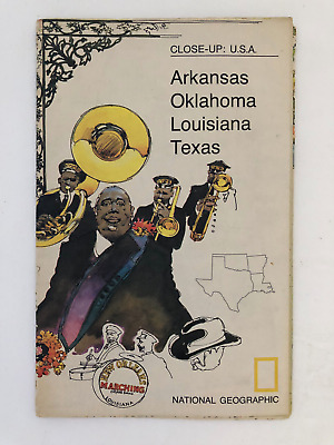
$5.49 Shipping Location: Georgetown, United States Template By Froo! National Geographic Map- 1974 Close-Up USA Oklahoma Texas Louisiana Arkansas National Geographic Map- 1974 Close-Up USA Oklahoma Texas ... moreLouisiana Arkansas Vintage 1974 two sided map Close-Up USA. Map shows Oklahoma, Louisiana, Arkansas, and Texas. The opposite side includes lots of historical information on the area by National Geographic Society. The map measures approx 35" x 23" in size. Never Unfolded. Shipping: All orders are carefully packaged. With a(Handle With Care Sticker) on the packaging. All orders ship the same or next business day. We ship orders Monday to Saturday. Orders placed before 2 pm(CST) on Fridays will ship on Saturday. We ship all orders via the United States Postal Service: First Class. Media Mail, Parcel Post, or Priority Mail, all include tracking numbers. Multi-Item Orders: We do combine shipping costs on multi-item orders. In order to receive the best shipping cost possible for your specific order please place your order. But before paying, request an invoice from us with combined shipping. We will return to you an adjusted invoice with the best shipping price for your order. Return Policy: Refunds given as money back or exchange(buyer’s choice) The buyer must pay return shipping. Please contact me within 14 days after receiving the item. Privacy Policy: Our company will never share your personal information in any way with an outside company. Our company will not send you unsolicited advertisements. Most reasonable offers are accepted. PayPal only. Please. Payment is expected within 2 days of auction end; immediate payment if you use Buy It Now. I will try and answer any questions. I am not an expert on anything I sell. And do my best to describe each item accurately. I buy many different items for the purpose of reselling them here on ebay. Any descriptions I give indicating the condition of item(s) such as: vintage. Antique, excellent, very good, good, and poor, or levels of functioning are purely subjective to what I observe, test and think of the item.
Buy It Now
$4.50 Shipping Location: Desoto, United States Vintage December 1929 National Geographic map! Has some wear from age and a few little rips but in good shape! I welcome any questions and as always happy ... morebidding!
Buy It Now
Free Shipping Location: Anaheim, United States Map Publisher: The National Geographic Society, Washington, District of Columbia, USA. Bio-predation & Oxidation (aging). THERE ARE HOLES ON THE FOLDS ... moreFROM BEING OPENED AND CLOSED. They are hard to see when laid flat.

Buy It Now
$13.20 Shipping Location: BECCLES, United Kingdom National Geographic map of the moon- very large- 28" x 50" great for classroom instruction on space Educational map published in February 1969. ... moreFeaturing detailed illustrations of both the near and far sides of the moon. This map also contains an abundance of illustrations and information about the moon including its physical properties and features, phases, eclipses, orbital paths, and the Apollo mission. Map features: Illustrations of the near and far sides of the moon including all the named features• The physical properties and features of the moon• Illustrations and information about the lunar month and the phases of the moon. Eclipses, libration, orbital paths, the tides, moon lore, and more• Information and illustrations about the Apollo mission• Moon comparisons and planet to satellite size ratio• Profile of a crater showing Copernicus. An average moon crater, in comparison to the Grand Canyon Map is in great shape. Many listings this week and we will combined shipping charges. Happy Looking! Posted with
Buy It Now
$17.91 Shipping Location: BECCLES, United Kingdom Format - Map.
Buy It Now
$4.50 Shipping Location: Desoto, United States This is a"Classical Lands of the Mediterranean" National Geographic folded map from December 1949 that is in fair to good condition. It measures ... moreapproximately 32 inches by 22 inches. It is intact with some minor wear and discoloration. This is my favorite of the 4 maps I have listed. Would look nice framed. S hipped first class mail within 24 hours of payment or on Monday if payment is on the weekend.

Buy It Now
$5.00 Shipping Location: Springfield, United States World War II Asia and the Pacific Map + Europe and North Africa National Geographic December 1991 This two-sided poster is in mint condition. It is 20" ... morex 27" 113 Click on the red book icon and check our Ebay store Heart for Ethiopia for more good buys. We have many books and other items. They are arranged in categories. Most are $1 or $2. All proceeds go to Ethiopia to provide for development and child education in rural Ethiopia. Because we are raising money for charity no item will ever be reduced below $1. We give a combined shipping discount on all media items. Shipping for each additional media item is only $1.50. 100% Satisfaction Guarantee Terms: Payment is due at end of auction. If payment is not received within 7 days it will be reported as unpaid and the item will be relisted. Combined shipping and handling is available on multiple purchases made within a week. Books cannot be combined with other items as they are sent by media mail. Shipping for books is calculated using the shipping cost of the heaviest book plus $1.50 for each additional book. Media mail takes 5 to 14 days. It includes tracking. If you are satisfied with your purchase. Please leave positive feedback. Good feedback will quickly be left for you when payment is received. Prioity mail is available for an additional fee. If there is a problem with your item. Please email before leaving feedback and give us a chance to correct the problem. Email us for international shipping costs. Customs may be charged on international shipments. All customs charges are the responsiblity of the buyer and are not included in the selling price. Feel free to email us if you have any questions or concerns. Powered by The free listing tool. List your items fast and easy and manage your active items. Powered by The free listing tool. List your items fast and easy and manage your active items. Powered by The free listing tool. List your items fast and easy and manage your active items. Powered by The free listing tool. List your items fast and easy an

Buy It Now
$5.49 Shipping Location: Georgetown, United States You are looking at a National Geographic Map Titled Precious Resource Water& The United States- November 1993. This Map is in good condition with ... morenormal wear. Their are two small tears in the middle of the map along the crease. The tears are small and do not take away from the functionality of the map. Map is from the Cartographic Division of the National Geographic Society. It is double sided and each picture represents one side. This map is a great educational tool and would be great in a classroom or for homeschooling. Item will be shipped in a bubble padded mailer. I have a lot of different maps for sale. Please look through my other auctions to find out all that I have for sale. Item is in Hand and Ready to ship. May even ship the same day. Comes from a pet free and smoke free home. Please ask all questions prior to bidding. I will answer them as quickly as possible. I Accept PayPal Only PAYMENT MUST be received with in 2 days of Winning the Auction. If payment is not received then an Unpaid Item Report will be opened and Auction will be re-listed Free First Class Shipping. Which includes tracking. Item usually ships within 24 hours after cleared payment is received. I will ship to the address provided to me through Pay Pal. I will ship to the Lower 48 States in the USA Only. Feedback: Your feedback is greatly appreciated. Thank you for your time. Powered by The free listing tool. List your items fast and easy and manage your active items.
Buy It Now
$7.00 Shipping Location: Deland, United States Vintage 1937 Modern Pilgrim's Map of the British Isles(the Kingdom of Great Britain and Northern Ireland and the Irish Free State) Prepared for the ... moreNational Geographic Society for National Geographic Magazine, Gilbert Grosvenor, Editor. Includes beautiful cameos of notable personalities from the various geographic areas. 36" x 29 1/2" Map is in very good pre-owned condition. As is typical of maps of this age. This map is fragile. g.RcmdId ViewItemDescV4,RlogId p4%60bo7%60jtb9%3Fuk%601d72f%2Bjw%60hquvg%3Eg-149c41ec260-0x103-
Buy It Now
$7.83 Shipping Location: Milwaukee, United States Explore the world with this beautiful National Geographic Atlas of the World, Revised Sixth Edition, published in 1995 by John Shupe. This original piece ... moreis in excellent shape and perfect for collectors or anyone looking to learn more about the world. The atlas features detailed world maps and includes information on the political and physical geography of each region. Whether you're a seasoned traveler or a student of geography, this Atlas is a must-have addition to your collection. The atlas comes in the format of a hardcover book and is perfect for displaying on a bookshelf or coffee table.
Buy It Now
Location: Deltona, United States This large vintage National Geographic world globe is a stunning addition to any antique or map collection. Measuring 38 inches in diameter, it features ... morea vintage original design with a blue color scheme and a rotating feature for easy viewing. The cartographer/publisher is William T. Peele, Chief Cartographer, and it dates back to 1976, making it a rare find for collectors. The globe is classified under the categories of Antiques, Maps, Atlases & Globes, and World & Celestial Globes. It's perfect for enthusiasts of vintage and historic items, or anyone looking to add a unique and timeless piece to their home decor.Please note compass glove topper missing, and some wear to globe
Buy It Now
$6.00 Shipping Location: Deland, United States Good condition.
Buy It Now
$5.62 Shipping Location: Mililani, United States Antique Map of the Western Theater of War 1918. 27" x 33" Folding Map.
Buy It Now
$5.30 Shipping Location: Holyoke, United States THIS IS A VINTAGE MAP OF AFRICA AND ADJOINING PORTIONS OF EUROPE AND ASIA. PUBLISHED IN 1922 BY THE NATIONAL GEOGRAPHIC MAGAZINE. MEASURES APPROX. 28 ... more1/2" BY 32" HAS A BIT OF WEAR AT SOME OF THE FOLD POINTS BUT EASILY TAPED, OVERALL INTACT AS SHOWN. LETTERING CRISP. NO RESERVE.
Buy It Now
$20.85 Shipping Location: Caledonia, United States NATIONAL GEOGRAPHIC. Laminated MAP of the MIDDLE EAST. Not Folded.

Buy It Now
$78.79 Shipping Location: Menifee, United States Normal 0 MicrosoftInternetExplorer4 Here is a great globe that shows ocean depths and mountain heights in meters. Amazing ocean detail, no political boundaries ... morejust the physical geographical characteristics of the globe. There is a mounting hole at the North and South Poles so the globe can be mounted on the heavy duty base either way for observation. A very attractive globe in great condition. Copyright 1978 National Graphic Society Washington. D.C. Condition issues: Condition issues: Some small nicks from the globe. The North Pole plastic part has deteriorated from time& sitting in the sun. There may also be slight fading from the sun. See pics for details. POSITIVE FEEDBACK IS ALWAYS APPRECIATED AND PROMPTLY RETURNED! Check out my! BEFORE you“BUY IT NOW” PLEASE: Read my item description very carefully. Always feel free to ask any questions before buying. Look at the pictures carefully as they are part of the description. This item is currently being stored in a smoke free facility. If you need additional pictures. Please ask. We certainly don't mind sending more. Please email me through eBay with questions or if you need a specific picture. I am happy to reply to any requests. I think I can also now email pictures through eBay. We are not always the experts on all the items that we sell however. We do try to make every effort to review the condition of each item and report to you what we see. Items are being sold as is. Payment is required immediately with purchase. However, other arrangements can be made such as paying within 3 days of purchase if we are contacted first. All items are shipped via USPS. UPS, or FEDEX to the lower 48 states. All customers will be issued a tracking number or USPS Delivery Confirmation number upon shipment. Most of our orders ship within 1 business day after payment has cleared. We are not responsible for carrier transit time. We do not ship during weekends or holidays. If you live somewhere else other than the lower 48 United States, we are sorry, but it may cos
Buy It Now
$4.13 Shipping Location: Saint Clair, United States I inspected each of these and opened them up to look them over. There could arise a pin-hole upon further handling however.
Free Shipping Location: Seven Valleys, United States Some wear. FREE LOCAL DELIVERY ON SALES TOTALING $15 OR MORE IN ST. JOHN'S/MOUNT PEARL AREA. ITEMS WILL BE DROPPED IN YOUR MAILBOX WITHIN 48 HOURS ... moreOF RECEIVING PAYMENT. BUYERS FROM AREAS CLOSE BY SHOULD CONTACT ME. I MAY BE ABLE TO OFFER FREE DELIVERY TO YOUR AREA. I only sell older used items. I accept PAYPAL. Feel free to contact me. I DO COMBINE S/H FOR MULTIPLE ITEMS. YOU WILL HAVE TO WAIT FOR or request MY INVOICE(not the end of auction email from ebay) TO GET THE LOWEST SHIPPING COST WHEN BUYING MULTIPLE ITEMS. Item Location: Maps Box 1. Item# 54:RcmdId ViewItemDescV4,RlogId p4%60bo7%60jtb9%3Fuk.rp73%28e013%3F%3E%3A-14346b7bf4c-0xec-
Buy It Now
$18.99 Shipping Location: Lynden, United States 1966 Vintage National Geographic Society World Globe Modernist RARE . Shipped with USPS Parcel Select Ground.
Buy It Now
$7.00 Shipping Location: Deland, United States Good shape.
Buy It Now
Free Shipping Location: Portland, United States This map has some wear at the corners and creases from being folded. I try to give as accurate of a description as I can and point out any flaws that ... moreI notice in an item. If I overlook something. Please bring it to my attention so I can address the issue. I want you to be happy with your purchase! I offer a generous shipping discount for multiple items.

Buy It Now
$3.15 Shipping Location: Portland, United States Vintage 1992 National Geographic Poster& Map of Amazonia(d) This double sided poster is in excellent condition. It has a informational Poster of Amazonia ... moreon one side and a full color map of the region on the other side. It measures approximately 28 x 20 inches in size. Please be aware that these National Geographic Maps are anywhere from 30 to 80 years old. They are printed on paper that is not acid free and in most cases have not been stored in the best way. So the maps you are buying will be in a condition that reflects both of these facts. The map you get may be worn or lightly torn along the fold lines due to the acidity of the paper and being folded for years. They may also be discolored or mottling spots again due to the acidity of the paper. The borders of the maps may also have small tears. On occasion maps may smell musty from the way they have been stored in the past. When the map is kept in an open area the musty smell will fade away in time. Any damage that is above and beyond the norm will be disclosed. Payment through Paypal only. Payment is required within four days. I do combine multiple purchases for shipping. If you have bought an item and are going to bid on a future item you must let me know if you want them shipped together. DON'T PANIC IF MY SHIPPING CHARGES SEEM HIGH! I sometimes just charge a higher amount because I am not sure of the package size however no profit is made on shipping and handling charges unless any special circumstances are involved. Any overcharge over $1.00(one dollar) will be refunded. If you feel you are owed a refund please let me know. Items are sold in"as in" condition. Should you have any problem with the item or you feel that it has been misrepresented. Please contact me so that we can reach a mutually satisfactory solution. Sorry but no overseas bidding without contacting me first. If your feedback score is less than 20 then please contact me before bidding.
Buy It Now
$3.65 Shipping Location: Portland, United States
Buy It Now
$9.35 Shipping Condition: Very Good Location: LEAMINGTON SPA, United Kingdom The National Geographic Society, Washington D.C. However, we are not experts.
Buy It Now
Free Shipping Location: Nampa, United States TODAY FOR SALE IS A CLASSIC 1954 MAP OF CALIFORNIA PUBLISHED BY NATIONAL GEOGRAPHIC SOCIETY. GREAT HISTORIC MAP IN GREAT CONDITION. WOULD LOOK GREAT FRAMED ... moreCHECK OUT THE PICTURES ASK QUESTIONS. SHIPS FIRST CLASS MAIL. THANK FOR VIEWING MY ITEM.
Buy It Now
$3.65 Shipping Location: Portland, United States The map is in great condition.
Buy It Now
$4.55 Shipping Location: Ithaca, United States NATIONAL GEOGRAPHIC SOCIETY MAP THE REACHES OF NEW YORK CITY APRIL 1939 VINTAGE Vintage National Geographic Scociety map The Reaches Of New York City ... morecirca April 1939. Measures 26 1/2 X 29 inches in size when fully opened(68 X 74cm) Map is an authentic original in good condition as shown in photos. 006.RcmdId ViewItemDescV4,RlogId p4%60bo7%60jtb9%3Fuk%600d72f%2B%3E006-14a19df28a3-0x105-
Buy It Now
$5.49 Shipping Location: Georgetown, United States North Dakota South Dakota Nebraska Kansas Minnesota Iowa Missouri Map.
Buy It Now
$4.50 Shipping Location: Desoto, United States United States and adjoining portions of Canada and Mexico Map May 1933 This large one-sided poster is in good condition with no marks or tears. Some folds ... morehave been taped for reinforcement. It is an original map that was in a National Geographic magazine. It is 27" x 40". 224.
3d 3h 2m 13s 0 bids
$3.95 Now
$2.59 Shipping Location: Salisbury, United States VINTAGE Italy map National Geographic Magazine- Atlas Plate 37 November 1961. FREE US SHIPPING! Will ship worldwide! Please check with me on costs of ... moreshipping outside of the US. Descriptions are to the best of my ability. However. I am not a collector so may not know the best way to describe the item. Please feel free to E-mail me with questions or for more pictures and check out my other auction items.
Buy It Now
$5.98 Shipping Location: Los Angeles, United States National Geographic Society - Printed in 2009 - Folded. The Indochina Peninsula seems to pour from the cast-ern bend of the Himalaya. Southeast Asia Map ... more- Large Size 20 in wide X 31 in. Northeast of Khone Falls, the fertile Bolovens Plateau is an isolated extrusion of basaltic lava.
Buy It Now
$4.99 Shipping Location: Rock Creek, United States 1937 NATIONAL GEOGRAPHIC MAP OF SOUTH AMERICA. FOLDED.
Buy It Now
$3.15 Shipping Location: Portland, United States Description: MAP of SOUTHERN AFRICA by National Geographic Society Date: Nov 1962 Size: 19 x 25 inches Condition: very good condition
Buy It Now
$5.49 Shipping Location: Georgetown, United States The Making of Alaska Map 1983, Map only.
Buy It Now
$6.05 Shipping Location: Merlin, United States This map, originally published by National Geographic Magazine, showcases the United Kingdom with detailed information about England and Ireland. The ... moremap has been well-preserved and is in good condition for its age.

Buy It Now
$3.15 Shipping Location: Portland, United States Africa Map National Geographic September 1960 This one-sided poster is in very good condition. It is 19" x 25" It will be shipped with a cardboard ... morestiffener. 313 Click on the red book icon and check our Ebay store Heart for Ethiopia for more good buys. We have many books and other items. They are arranged in categories. Most are $1 or $2. All proceeds go to Ethiopia to provide for development and child education in rural Ethiopia. Because we are raising money for charity no item will ever be reduced below $1. We give a combined shipping discount on all media items. Shipping for each additional media item is only $1.50. 100% Satisfaction Guarantee Terms: Payment is due at end of auction. If payment is not received within 7 days it will be reported as unpaid and the item will be relisted. Combined shipping and handling is available on multiple purchases made within a week. Books cannot be combined with other items as they are sent by media mail. Shipping for books is calculated using the shipping cost of the heaviest book plus $1.50 for each additional book. Media mail takes 5 to 14 days. It includes tracking. If you are satisfied with your purchase. Please leave positive feedback. Good feedback will quickly be left for you when payment is received. Prioity mail is available for an additional fee. If there is a problem with your item. Please email before leaving feedback and give us a chance to correct the problem. Email us for international shipping costs. Customs may be charged on international shipments. All customs charges are the responsiblity of the buyer and are not included in the selling price. Feel free to email us if you have any questions or concerns. Powered by The free listing tool. List your items fast and easy and manage your active items. Powered by The free listing tool. List your items fast and easy and manage your active items. Powered by The free listing tool. List your items fast and easy and manage your active items. Powered by The free listing tool. List your items fast and easy an
Buy It Now
$5.95 Shipping Location: Newbern, United States
Buy It Now
$6.05 Shipping Location: Moravia, United States
Buy It Now
$7.00 Shipping Location: Deland, United States Map by A. Hoen & Co (Baltimore).
Buy It Now
$4.15 Shipping Location: Powder Springs, United States This detailed and informative map is the perfect tool for any traveler looking to explore the city.
|
|
|
In
|
Vintage 1975 National Geographic Map of New Hampshire Vermont Massachusetts ..
Vintage 1975 National Geographic Map of New Hampshire Vermont Massachusetts Rhode Island Connecticut(d) This map is in excellent condition. It measures approximately 37 x 28 inches in size. Please be aware that these National Geographic Maps are anywhere from 20 to 80 years old. They are printed on paper that is not acid free and in most cases have not been stored in the best way. So the maps you are buying will be in a condition that reflects both of these facts. The map you get may be worn or lightly torn along the fold lines due to the acidity of the paper and being folded for years. They may also be discolored or mottling spots again due to the acidity of the paper. The borders of the maps may also have small tears. On occasion maps may smell musty from the way they have been stored in the past. OWhen the map is kept in an open area the ... moremusty smell will fade away in time. Any damage that is above and beyond the norm will be disclosed. Payment through Paypal only. Payment is required within four days. I do combine multiple purchases for shipping. If you have bought an item and are going to bid on a future item you must let me know if you want them shipped together. DON'T PANIC IF MY SHIPPING CHARGES SEEM HIGH! I sometimes just charge a higher amount because I am not sure of the package size however no profit is made on shipping and handling charges unless any special circumstances are involved. Any overcharge over $1.00(one dollar) will be refunded. If you feel you are owed a refund please let me know. Items are sold in"as in" condition. Should you have any problem with the item or you feel that it has been misrepresented. Please contact me so that we can reach a mutually satisfactory solution. Sorry but no overseas bidding without contacting me first. If your feedback score is less than 20 then please contact me before bidding.
|
|
|
VINTAGE NATIONAL GEOGRAPHIC MAP OF THE NORTHEASTERN UNITED STATES APRIL 1959
FOR YOUR CONSIDERATION IS AN APRIL 1959 NATIONAL GEOGRAPHIC MAP OF THE NORTHEASTERN UNITED STATES. IT IS IN VERY GOOD CONDITION AND DOES NOT HAVE ANY TEARS. RIPS, ETC. INTERNATIONAL BIDDERS ARE WELCOME. I WILL SHIP WORLDWIDE. IF YOU HAVE ANY QUESTIONS PLEASE E-MAIL ME. WHEN POSSIBLE I AM HAPPY TO COMBINE SHIPPING TO SAVE ON COSTS. Powered by The free listing tool. List your items fast and easy and manage your active items.
|
|
|
National Geographic November 1933 Aerial Photograph of GREATER NEW YORK Supplmnt
Description: Special Supplement MAP GREATER NEW YORK/ Metropolios of Mankind by National Geographic Society Date: Nov 1933 Supplement Condition: very good condition. STOCK PHOTOS ONLY Size: 19.5 x 23.5 inches Magazine is not included. Please check out my store for its availability Serious Bidder Only Please. Ask question if any. Shipping: USA: $2.75 first class or $5.50 Priority Mail For each additional map. Add $1 Free shipping with a purchase of any magazine. Canada: $4.99 airmail letter post or $13.99 global priority For each additional map. Add $1 Free shipping with a purchase of any magazine. International: $6.99 airmail letter post or $17.99 global priority mail For each additional map add $1 Free shipping with a purchase of any magazine. Payment: Payment is due within 7 days. Please contact me within 3 days to arrange payment if you ... moredo not pay instantly by Paypal. Return: I do not except return unless I send the wrong item(s) or item(s) that are not as described. Item(s) returned must be in the same condition it was sent. Refund will cover the bid amount but not shipping.
|
|
|
Vintage 1975 MAINE & CANADA MAP National Geographic NOVA SCOTIA Prince Edward
Gorgeous color fold-out map of Maine and the Canadian Maritime Provinces. Topographical color map on front. Historical info and illustrations on back. Includes: Maine. Nova Scotia, Cape Breton Island, Prince Edward Island& New Brunswick. Published by the National Geographic Society in March. 1975. 35" x 22.75" unfolded. It is in good vintage condition It would look great framed. Payment: I accept paypal. Payment due 5 days from end of auction. 1st class mail can be slow. Choose the priority option if you want it delivered fast. International bidders must email me for AIRMAIL shipping rates. Feel free to email me with any questions. Email me for a combined total if you buy more than one of my auctions. See my other auctions for more books. Antiques and collectibles.
|
|
|
National Geographic MAP February 1985 Northern Approach
Description: Double sided MAP/Supplement of The Making of America: NORTHERN APPROACHES by National Geographic Society The map covers Maine. And part of Canada including Nova Scotia, Brunswick, Date: February 1985 Supplement Condition: excellent condition Size: 20.5 x 27 inches Magazine is not included. Please check out my store for its availability Serious Bidder Only Please. Ask question if any. Shipping: USA: $2.50 first class or $5.49 Priority Mail within the lower 48 states. For each additional map. Add 50 cent Free shipping with purchased of any magazine. Canada: $3.99 first l class mail or $12.99 priority mail For each additional map. Add $1 Free shipping with purchased of any magazine. International: $5.99 first class mail or $13.99 priority mail For each additional map add $1 Free shipping with purchased of any magazine. Payment: ... morePayment is due within 7 days. Please contact me within 3 days to arrange payment if you do not pay instantly by Paypal. Return: I do not except return unless I send the wrong item(s) or item(s) that are not as described. Item(s) returned must be in the same condition it was sent. Refund will cover the bid amount but not shipping.
|
|
|
National Geographic Supplement MAY 1957 MAYFLOWER II Poster
Description: Supplement of MAYFLOWER II by National Geographic Society Date: November 1957 supplement Condition: very good condition Size: 18 x 24 inches Magazine is not included. Please check out my store for its availability Serious Bidder Only Please. Ask question if any. Shipping: USA: $2.75 first class or $5.50 Priority Mail within the lower 48 states. For each additional map. Add $1 Free shipping with purchased of any magazine. Canada: $4.99 airmail letter post or $13.99 global priority For each additional map. Add $1 Free shipping with purchased of any magazine. International: $6.99 airmail letter post or $17.99 global priority mail For each additional map add $1 Free shipping with purchased of any magazine. Payment: Payment is due within 7 days. Please contact me within 3 days to arrange payment if you do not pay instantly by Paypal. ... moreReturn: I do not except return unless I send the wrong item(s) or item(s) that are not as described. Item(s) returned must be in the same condition it was sent. Refund will cover the bid amount but not shipping.
|
|
|
NATIONAL GEOGRAPHIC MAP THE WHITE MOUNTAINS REGION NEW HAMPSHIRE 1937 VINTAGE
NATIONAL GEOGRAPHIC MAP THE WHITE MOUNTAINS REGION NEW HAMPSHIRE 1937 VINTAGE Description: Vintage National Geographic map of The White Mountains New Hampshire circa July 1937. Measures 17 X 20 inches in size when fully opened(43 X 51cm) Map is an authentic original in acceptable condition as shown in photos.
|
|
|
National Geographic MAP of U.S. NEW ENGLAND JUNE 1955 29" x 41"
2 small pin holes at the seem. slightly soiled around the fourth block of the map on the right side
|
|
|
JULY 1937 NATIONAL GEOGRAPHIC MAP THE WHITE MOUNTAINS OF NEW HAMPSHIRE
THIS AUCTION IS FOR A JULY 1937 NATIONAL GEOGRAPHIC MAP THE WHITE MOUNTAINS OF NEW HAMPSHIRE IN OVERALL VERY GOOD CONDITION. LOOK FOR PHOTO(s) BELOW TO ENLARGE PICTURE. I COMBINE POSTAGE COSTS. LOOK AT THE OTHER ITEMS OF THIS TYPE THAT I NOW HAVE LISTED OR WILL BE LISTING IN THE COMING WEEKS IF YOU LIKE. PLEASE LOOK ABOVE FOR POSTAGE. HANDLING AND DELIVERY CONFIRMATION COST FOR THIS LISTING MOST ITEMS ARE SENT IN A SECURE BOX AND WRAPED IN PLASTIC AND I WILL SEND YOU A DELIVERY CONFIRMATION THROUGH EMAIL( MOST OF THE TIME THROUGH YOUR PAYPAL PAYMENT) SO YOU CAN TRACK IT. GO TO THE USPS SITE TO TRACK. THE POSTAGE PRICE YOU SEE INCLUDES $1.00 FOR SMALL BOXES. PACKAGES UP TO $5.00 FOR LARGE BOXES FOR HANDLING AND MATERAILS( TAPE AND COST OF BOXES) FOR INTERNATIONAL BUYERS ITEMS WILL BE DECLARED AS MERCHANDISE. If you are not using Priority mail ... moreor 1st class please expect 2 to 7 days if you live on the east coast or 7 to 12 days if you live on the west coast for delivery through the USPS depending were you live it can be slow. International winners please expect 1 to 2 weeks depending were you live IF YOU LIVE IN THE ROCHESTER AREA OR PLAN TO VISIT IN THE NEAR FUTURE YOU CAN PICK UP ANY AUCTION ITEM WON SO YOU DONT HAVE TO PAY FOR POSTAGE. IF YOU BUY MORE THAN 1 LOT WITHIN 5 TO 7 DAYS I WILL COMBINE POSTAGE IF POSIBLE. PLEASE WAIT UNTIL YOU ARE FINISHED BUYING IN THE 2 TO 5 DAY SPAN AND THEN ASK ME TO SEND YOU A INVOICE SO I CAN GIVE YOU THE BEST POSSIBLE POSTAGE PRICE* NEW YORK RESIDENTS PLEASE ADD 8% STATE SALES TAX REFUNDS: Items are Non-Refundable unless a error has been made in description. If you contact me within 4 days of receiving the item AND NOT AFTER 21 DAYS OF THE AUCTION CLOSE. Item(s) must be sent back to me as i had sent them to you LOOK AT MY OTHER ITEMS LISTED ON EBAY AND IN MY STORE IF YOU LIKE. THANK YOU.
|
|
|
NEW HAMPSHIRE,VERMONT,MASS.,RHODE IS.,CONN. National Geographic Map*JULY 1975
Map 23 x35" Unfolded for the first time to list. like new condition. From National Geographic JULY 1975. Map of the areas on one side and on verso all the important facts about the communities. Thanks so much. Will combine shipping on like items.
|
|
|
THE WORLD MAP - PUBLISHED 1943 BY NATIONAL GEOGRAPHIC
YOU'RE BIDDING ON AN ORIGINAL PRINTED VERSION OF A PICTORIAL MAP OF THE WORLD ISSUED BY NATIONAL GEOGRAPHIC. DATED AND COPYRIGHTED DECEMBER 1943. MAP HAS SOME BENT/WORN CORNERS AND FOLD LINES/SLIGHTLY TORN. U.S. SHIPPING IS FREE. PRIORITY FLAT RATE MAIL OPTION ALSO OFFERED. INTERNATIONAL BIDDERS MUST AGREE TO PAY USPS PRIORITY MAIL FLAT RATE INTERNATIONAL SHIPPING COSTS(NO EXCEPTIONS) Powered by The free listing tool. List your items fast and easy and manage your active items. RcmdId ViewItemDescV4,RlogId p4%60bo7%60jtb9%3Fuk.rp*73c7e%3D%3E-140476d5fd0-0xfd-
|
|
|
New Hampshire The White Mountains The National Geographic Magazine
Foot Trails. Ski Trails, Waterfalls, Fire Lookouts, Summits, Elevations in Feet. Main Haighways, Other Highways, Landing Fields, Albert H. Humstead- Chief Cartographer. Sketches by Margaret B. Austin
|
|
|
Vintage 1987 National Geographic Map New England
Vintage 1987 National Geographic Map New England The map is in excellent condition. It measures roughly 38 x 20 inches in size. Please be aware that these National Geographic Maps are anywhere from 30 to 80 years old. They are printed on paper that is not acid free and in most cases have not been stored in the best way. So the maps you are buying will be in a condition that reflects both of these facts. The map you get may be worn or lightly torn along the fold lines due to the acidity of the paper and being folded for years. They may also be discolored or mottling spots again due to the acidity of the paper. The borders of the maps may also have small tears. On occasion maps may smell musty from the way they have been stored in the past. When the map is kept in an open area the musty smell will fade away in time. Any damage that is above ... moreand beyond the norm will be disclosed. Payment through Paypal only. Payment is required within four days. I do combine multiple purchases for shipping. If you have bought an item and are going to bid on a future item you must let me know if you want them shipped together. Items are sold in"as in" condition. Should you have any problem with the item or you feel that it has been misrepresented. Please contact me so that we can reach a mutually satisfactory solution. Sorry but no overseas bidding without contacting me first. If your feedback score is less than 20 then please contact me before bidding. RcmdId ViewItemDescV4,RlogId p4%60bo7%60jtb9%3Fvo%7B%3Dd70f%2Bf52%3E-1440a3c9d0f-0xfc-
|
|
|
NATIONAL GEOGRAPHIC MAP WHITE MOUNTAINS NEW HAMPSHIRE REGION JULY 1937 VINTAGE
NATIONAL GEOGRAPHIC MAP WHITE MOUNTAINS NEW HAMPSHIRE REGION JULY 1937 VINTAGE National Geographic Society map New Hampshire White Mountains circa July 1937. Measures 17 X 20 inches in size when fully opened(43 X 51cm) Map is an authentic original in acceptable condition as shown in photos.
|
|
|
Vintage National Geographic Map - South Central United States - February 1961
Vintage National Geographic Map- South Central United States- February 1961- 19" x 23" Map is in great condition and appears to have never been opened. Shipping only $2.95 in the US for any quantity of maps! When buying multiple maps. Please do not pay until we send invoice with correct shipping. We ship internationally, cost based on destination country. We pride ourselves on our eBay status and customer satisfaction. See our other great items in our eBay store thanks for looking! location code: N3)
|
|
|
1937 Early National Geographic Pictorial Map White Mountains New Hampshire Nice
Here is a nice early National Geographic Society Pictorial Map of the White Mountain Region in New Hampshire. The map is dated 1937 and would have been a supplement to the July. 1937 edition of National Geographic Magazine. This map is an example of a true pictorial map produced by the National Geographic Society and distributed via a magazine insert. Dating from the Golden Era of the pictorial map, the 1930's. By 1950, Nat Geo produced"pictorial maps" in name only; they contained illustrations, but the cartography superseded the art, in my opinion. The"pictorial-ness" of this map is confined to the inner border. But this was a type of pictorial map seen in the 1920's and 1930's. Actually, the geographic part of this map. The Whie Mountains. Is probably an illustration. Too, or taken from an illustration; the ... moretechnique is called" Shaded Relief" And in this day was done as art. The map was illustrated by Margaret B Austin. The map was printed by A. Hoen& Company. Baltimore. A road map with counties. Cities, rivers and other water courses, and boundaries is superimposed over the shaded relief representing the mountains. The map was, of course, folded, into six panels, being a loose magazine insert. The map is a compact 20" x 17" At the bottom is an insert location map showing the relative location of the White Mountains. This map is in excellent condition with only very minor wear. Please see the Description Section where I go into detail as to condition. Not scarce. And not hi-tech, like today's Nationial Geographic maps, but a sharp-looking, framable map for Nat Geo fans. I ship USPS. Fedex, or UPS, depending on which is the most practicable given the item being shipped. This would come USPS First Class Mail. I reimburse immediately via Pay Pal for any shipping fees sent that are not needed. Pay Pal only. I ship within 12-24 hours of payment, so I do require payment within 48 hours. Thanks for looking!
|
|
|
1937 Vintage Map Of White Mountains New Hampshire National Geographic Magazine
National Geographic Magazine Map Of White Mountains Of New Hampshire Vintage map in Good overall condition Nice piece to have framed Great Details Measures Approx. 20" wide x 17" tall Never any reserve price& combind shipping is always available. Happy Bidding.RcmdId ViewItemDescV4,RlogId p4%60bo7%60jtb9%3Fvo%7B%3Dd70f%2Bf%60%60%3E-1470db63463-0x110-
|
|
|
National Geographic Map: United States - Washington to Boston August 1962 (N153)
Shipping Information National Geographic Map: United States- Washington to Boston August 1962(N153) Description: Here is a National Geographic map titled United States: Washington to Boston dated August 1962. This particular map has only one side. And is listed below with pictures and descriptions. If you are planning on buying more than one of my maps make sure you read the shipping information below. Click on the thumbnails to see the enlarged pictures. United States Washington to Boston- August 1962(25"x19" This political map has a collection of detailed insets of Washington. Boston, Baltimore, Philadelphia and New York. It also contains insets of tourist Boston and tourist Washington. Please Note: The vast majority of the maps I have up for sale are in excellent condition and look just as good as the map in the picture. However. ... moreSome of these maps, especially the older ones, might have some small defects, such as a small tear or soiling at the seams. I will make every effort to send you the best map I have. If the map does have one of these small defects, I will email you and let you know what the defect is, and give you the option of cancelling the auction or giving you a discount on the shipping cost. N153) This map weighs 20 grams Be sure to check out my page for information on my web site dedicated to helping you find a particular National Geographic map to meet your needs. Shipping Information: If just buying one map the shipping cost will show up in your invoice. I will gladly ship multiple maps in one package to save you the cost of shipping. Just buy the maps you want and wait for me to combine all your auctions together into one invoice and revise the shipping cost before you pay. To get an idea of the shipping cost read below. Most of my maps will be sent by Canada Post Letter mail as long as the height of the package does not exceed 2 centimetres. If over 2 centimetres they will be mailed by Canada Post Regular mail in Canada and Small Packet Air/Surface to the USA or International locati
|
|
|
The White Mountains of New Hampshire National Geographic Society 1937 lithograph
The White Mountains of New Hampshire National Geographic Society 1937 lithograph. Title: The White Mountains of New Hampshire Maker: National Geographic Magazine(Albert H. Bumstead. Chief Cartographer& Margaret B. Austin, Sketches) Date: 1937 Printing: Lithograph Measures: 20 in x 17 in Description: Wonderful lithograph of the White Mountains of New Hampshire showing foot trails. Ski trails, waterfalls, fire lookouts, summits, main highways, landing fields and elevations(in feet) Ships within the U.S. only. California residents will be charged sales tax. inkfrog terapeak. I000000. InkFrog Analytics.
|
|
|
ANTIQUE / VINTAGE NATIONAL GEOGRAPHIC map of the WHITE MOUNTAINS, NH, 1937
This is a map from National Geographic map of the WHITE MOUNTAINS in New Hampshire. Printed in 1937. This is folded and in excellent condition. Having been stashed away for many years! The dimensions are 17" by 20" Item will be shipped within 2 business days. Once payment is received. I am happy to combine shipping when possible. Please e-mail if you have any questions. Thanks for looking! I am cleaning out items from my childhood home.and there is more to come! Check out my other items- opens in a new window or tab! Check out my etsy site: bojocreations.com
|
|
|
Vintage 1937 National Geographic map of White Mountains of New Hampshire USA
Vintage Map by the National Geographic Society. This is 1937 map of the White Mountains of New Hampshire. Size is 20"x17" in good condition. Has creases from being folded. Will be shipped folded and flat(first class. Free shipping) or rolled in a tube(Priority Mail) Any questions, please ask. Payment is due within 3 days of purchase. Unless other arrangements have been made. We accept Paypal and payment on pickup. Items will be shipped once payment has been received and processed. Shipping* We'll gladly ship internationally. We will combine shipping! We always will try to get you the best price. LOOK at the price of the shipping before you bid. Expect the shipping cost to be at least $6-7 if the item requires a box to ship because it will weigh at the minimum 1-2 pounds. We are not making money on shipping. This money goes to ... morethe post office and the cost of supplies and insurance. We do make mistakes so if it is a small item. Let us know if the shipping seems too high. All items shipped by Priority Mail or UPS will be insured at no cost to you. In the unlikely event the item arrives broken. Please send us pictures of the broken item and contact us. We can decide who will file the claim based on your preference. Condition* All Items from a local estate. So we will describe them as best as possible and point out any flaws we notice. Vintage items may not be perfect AND may need a cleaned due to storage and/or age. Remember condition is a judgment call. We sell primarily vintage and collectable items. Please only expect them to be perfect if we state that the item is"new in the package. Excellent" means that it is in used but very much like new condition. Great" means nice condition, few noted flaws or damage and the item is in a nicer condition, but used. Good" means that it is usable, generally intact, and maybe one or two noticeable flaws. Acceptable" means several noticeable flaws, but still useful. We will not sell poor items, unless they are very rare. Return Policy* Retu
|
|
|
National Geographic Maps MapQuest State Guide MAINE c.1999 - laminated
Waterproof Plastic Map- laminated ISBN: 1-57262-490-6 © 1999 CONDITION: NEW Map Publisher: MapQuest.com in association with National Geographic Maps Map is folded. When folded the map measures approximately 9 inches by 4 inches. Title Panel Claims from the publisher: MORE THAN A MAP What to see and do in Maine Top attractions and events Recommended scenic routes East-t-use. Detailed road maps Wiatava Lodge#13 of Orange County Council#39. Boy Scouts of America International Buyers Please Note: Customs/ Import duties. Taxes, and charges are not included in the item price or shipping charges. These charges are the buyer’s responsibility. Please check with your country's customs office to determine what these additional costs will be prior to bidding/buying. In some situations some items are not allowed to be sent to your country because ... moreof the buyers import laws. Buyers please check that an item is allowed to be sent to your country. These charges are normally collected by the shipping delivering freight company or when you pick the item up. Do not confuse them for additional shipping charges from me. The amount reported to Customs for merchandise value is the amount of the items plus the amount of shipping. We do not mark merchandise values below value or mark items as" gift" US and International government regulations prohibit such behavior. ID: map2085 Powered by SixBit's eCommerce Solution
|
|
|
National Geographic 1975 Close Up USA Maine insert map 23 x 35" MINT CONDITION!
You're bidding on an original vintage 1975 National Geographic Close-UP: U.S.A. double sided map insert of Maine. This is an original vintage insert that I removed from the magazine. And not a later reissue as part of a set. The scans are of the actual map you will get. Measures about 6 x 9" folded and about 23 x 35" unfolded and is in MINT condition. No rips. Tears, perforations, stains, writing or objectionable odor detected. Will be shipped to USA via USPS First Class Mail. P lease check my other auctions. Excellent feedback, tenure with ebay and bid with confidence. Powered by The free listing tool. List your items fast and easy and manage your active items.
|
|
 |