-
Christian Collectibles
-
Christian Sheet Music
-
Vatican Stamps
-
Vatican Coins & Paper Money
-
Antiques
-
Antiquities
-
Architectural & Garden
-
Decorative Arts
-
Ethnographic
-
Furniture
-
Maps, Atlases & Globes
-
United States (Pre-1900)
-
United States (1900-Now)
-
AK, HI
-
AL, FL, GA, MS, NC, SC
-
AR, IA, KS, LA, MO, NE
-
AZ, CA, CO, NM, NV, UT
-
CT, MA, ME, NH, RI, VT
-
DC, DE, MD, NJ, NY, PA
-
ID, OR, WA
-
IL, IN, MI, OH, WI
-
MN, MT, ND, SD, WY
-
OK, TX
-
VA, WV, KY, TN
-
Entire US
-
United States (Date Unknown)
-
Africa
-
Asia
-
Australasia/ Oceania
-
Canada
-
Central America/ Caribbean
-
Europe
-
India
-
Ireland
-
Mexico
-
Middle East
-
North America
-
South America
-
United Kingdom
-
Maps on CD
-
World Maps
-
Globes
-
Mixed Lots
-
Reproductions
-
Price Guides & Publications
-
Other
|
In
Order by: Available to: This site contains affiliate links for which I may be compensated
|
Buy It Now
$8.51 Shipping Location: Medford, United States In Bromley's Atlas of 1883, this map is identified as Plate K. Assessors and various other city officials (planners, fire and police forces, utility and ... moreservice providers, etc.) thereby had critical information readily available.
Buy It Now
$8.51 Shipping Location: Medford, United States In Bromley's Atlas of 1883, this map is identified as Plate I. Assessors and various other city officials (planners, fire and police forces, utility and ... moreservice providers, etc.) thereby had critical information readily available.
Buy It Now
Location: Salem, United States Antique Franklin County Massachusetts map, 1858, Done by H. F. Walling. Antique wooden dowels. Map is worn, see photos. Backed with fabric. Overall fair ... morecondition.
Buy It Now
$8.51 Shipping Location: Medford, United States In Bromley's Atlas of 1883, this map is identified as Plate B. Assessors and various other city officials (planners, fire and police forces, utility and ... moreservice providers, etc.) thereby had critical information readily available.
Buy It Now
$5.75 Shipping Location: Boonville, United States Emma Dixon (Owner). Antique Ma O'hara's Ash Tray. Hardware, Junk, Embellish. Authentic, Last, Bygone Era, Rustic, Relic. Folk Art, Rusty, Relic. About ... more200 sided with the Union. The courthouse grounds on which the statue stands belongs to Calloway County and the County Court voted unanimously in 2020 to keep the statue rather than relocate it from courthouse grounds.
Buy It Now
$5.75 Shipping Location: Dayton, United States This is a Map titled "Chelsea River, Boston Harbor, Massachusetts, From Grand Junction R.R. Bridge To Boston & Maine R.R. Bridge," 1894. Map is in Very ... moreGood Condition! Any Browning Is Enhanced By My Phone!
Buy It Now
$6.50 Shipping Location: Pomfret Center, United States THIS IS NOT A REPRINT AND A GREAT BUY AT THIS PRICE.
Buy It Now
$3.95 Shipping Location: Avondale, United States
Buy It Now
$9.00 Shipping Location: New Hope, United States Very good condition, folds.
Buy It Now
$6.35 Shipping Location: Hanover, United States It is from the Atlas of Mass. by Geo. H. Walker Publisher. - See photos.
Buy It Now
$3.95 Shipping Location: Avondale, United States CONDITION : Repaired tear with archival tape upper left side of map on back.
Buy It Now
Free Shipping Location: Augusta, United States This 11 1/2" x 13 1/2" map is in VERY GOOD+ condition with very light age tone, soil, and edge wear, from a disbound Cram's atlas ©1892. "An authentic ... moreoriginal map not a reproduction".
Buy It Now
$24.10 Shipping Location: Brattleboro, United States Super nice condition for it's age. Ready for framing !
Buy It Now
$8.51 Shipping Location: Medford, United States In Bromley's Atlas of 1901, this map is identified as Plate 16. Assessors and various other city officials (planners, fire and police forces, utility ... moreand service providers, etc.) thereby had critical information readily available.
Buy It Now
$8.51 Shipping Location: Medford, United States In Bromley's Atlas of 1883, this map is identified as Plate L. Assessors and various other city officials (planners, fire and police forces, utility and ... moreservice providers, etc.) thereby had critical information readily available.
Buy It Now
$8.51 Shipping Location: Medford, United States In Bromley's Atlas of 1901, this map is identified as Plate 24. Assessors and various other city officials (planners, fire and police forces, utility ... moreand service providers, etc.) thereby had critical information readily available.
Buy It Now
Free Shipping Location: Hampton, United States Hand-Colored Antique Map An original antique map from an 1870 Atlas of Worcester Country. Massachusetts, from actual surveys by and under the direction ... moreof F. W. Beers, assisted by Geo. P. Sanford and Others. Published by F. W. Beers& Co. 1870. Louis E. Neuman, Engraver. Chas. Hart, Lithographer. Size: 15 1/2" x 12 3/4. Hand-colored. Showing building placement and building owners' names. Condition: Chipping along upper edge from atlas binding. 5 small holes in the margin from the binding stitching. Lightly yellowed. Light rippling in margins. In very good condition. Clean. Colors bright. Guaranteed original from 1870. A nice antique map that would look great framed!
Buy It Now
$4.95 Shipping Location: Avondale, United States
Buy It Now
$7.09 Shipping Location: Hanover, United States As well as the Fore River. There are faint water mark discolorations at left and right bottom sections (see photos).
Buy It Now
Free Shipping Location: Chelsea, United States Sold as is. Look at photos for details.
Buy It Now
$7.09 Shipping Location: Hanover, United States It is from the Atlas of Mass. by Geo. H. Walker Publisher. - See photos.
Buy It Now
$92.40 Shipping Location: Weymouth, United States Antique Map Weymouth MA Illustrated Bird’s Eye Type 1880 Beck & Paul E H Bigelow. It is in a contemporary frame that measures 25" x 37"; the map itself ... morelooks about 24" x 32". Made by Beck & Paul Lith. Co. Milwaukee Wisconsin for E H Bigelow of Framingham Mass. dated 1880 and is a genuine 142 years old print. Has a lot of wear and tears, there is a very old hand stitched sewn repaired tear center, the right edge has tears and wear under the frame. So far from mint condition but displays OK. See my photos.
Buy It Now
$30.00 Shipping Location: Paris VI, France Edition : Paris, 1683, 17th Century. Title of the view.
Buy It Now
$7.09 Shipping Location: Hanover, United States (D.G. Beers, J.H. Goodhue, H.B. Parcell). - Map image 14.5” x 12” (approx).
Buy It Now
$28.70 Shipping Location: Hanover, United States This is an original hand colored double page map of the Town of Middleborough from the 1879 Atlas of Plymouth County Mass. published by Geo. H. Walker ... more& Co. A copy of the Frontis page from the 1879 Plymouth county Atlas will be included.
Buy It Now
Free Shipping Location: Greenfield, United States Blueprint with pencil annotations.
Buy It Now
Free Shipping Location: Schertz, United States This antique plat atlas map, printed in 1873 by G.M. Hopkins & Co. showcases the areas of the MOUNT AUBURN & CAMBRIDGE CEMETERY, COOLIDGE Ave., MOUNT ... moreAUBURN, BRATTLE Streets in Cambridge, Massachusetts. Perfect for genealogy and family history research, this map is over 150 years old and provides a glimpse into the past. Please note that the cover and title page are not included, they are only for reference. In addition, free shipping is available for customers in the USA, while calculated shipping is available for those outside the country. Explore the landowners and county of Middlesex County, as depicted on the map. Don't miss out on this unique opportunity to own a piece of history.
Buy It Now
$7.09 Shipping Location: Hanover, United States This is an original 1871 Plymouth County Map from the 1871 Massachusetts Atlas. This is not a reproduction.The map shows the towns of Plymouth County ... moreincluding railway lines.The map will be shipped with a copy of the Atlas Frontice page to authenticate it. It is in excellent condition and is hand colored. The map as a center fold as it came from an Atlas.The map measures 25.5” x 17”.It will be shipped flat to prevent creases from rolling and shipped along with a copy of the Atlas front page for authentication.Please see our other maps in our EBay store.
Buy It Now
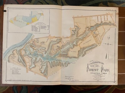
$15.00 Shipping Location: Orange, United States Normal 0 false false false EN-US JA X-NONE 1899 Antique Atlas Hand Colored Topographical Map Forest Park Springfield MA Removed from an 1899 City of Springfield ... moreMA Atlas Published in Springfield. MA by J L Richards. Printed on lightly coated period linen( backed paper as issued which retains its inherent structural flexibility and soundness; has detailed park features such as Pecousic Villa(Everett Barney’s home) King Phillips Indian Stockade, Aquatic Gardens, Lotus Pond, Skating Pond, The Playground, Deer Preserve, Swan Pond, Children’s Paddle Pond, Bear Pit, Menagerie Building, the mysterious“Dean Massacre” site, etc. Shows original road network(now substantially changed) shows location of the Pecousic railroad station where day visitors got on and off the train. Shows the sources of the park land by gift and purchase including land from famous local families: Barney. Chapin, Southworth, McKnight, Wesson, Merriam, and Stebbins Most individual buildings then existing are clearly visible as structures; old(and many now changed) street names are shown This scarce old map has been nicely beautifully printed and lithohraphed on an oversized folio sheet. Allowing for a reliable and precise detailed rendering In VERY GOOD/ EXCELLENT condition: displays normal minor light age toning. Staining or foxing; overall the map remains very clean and very displayable. Please note: the lighting for the photos is terrible. The photos make this look there is lots of staining. Especially down the centerline fold but that is not the case. This displays beautifully in person. Note the zoom feature which allows for very close inspection. Minor defects along the sheet edges and corners do not detract. Super old printed paper map entirely worthy of any collection and/ or display. A cartographic depiction captured in a manner entirely unique to this particular historical era. Not only is the artistic style interesting. But the historical method used for printing it essentially no longer exists. This renders the sheet of pape
Buy It Now
$8.51 Shipping Location: Medford, United States In Bromley's Atlas of 1901, this map is identified as Plate 16. Assessors and various other city officials (planners, fire and police forces, utility ... moreand service providers, etc.) thereby had critical information readily available.
Buy It Now
$8.51 Shipping Location: Medford, United States In Bromley's Atlas of 1901, this map is identified as Plate 9. Assessors and various other city officials (planners, fire and police forces, utility and ... moreservice providers, etc.) thereby had critical information readily available.
Buy It Now
$15.00 Shipping Condition: Used Location: Bridgewater, United States A great bit of BROCKTON History here, as this may be the lone surviving copy of Historical Architectual plans/Map - a BROCKTON, Mass. Architects 1920 ... morerendering for creation of the old Brockton High School Football Field, Baseball diamond, Track, and Graduation Field - the ELDON B KEITH Field at 128 West Elm Street in Brockton, Massachusetts. The facility was built and then given to the City of Brockton by the famous George E Keith in dedication to his son who had died in 1919 while in service of the US Government. George Keith was the owner of the company using his name, the manufacturer of WALK-OVER Shoes. This original plan Map from 1920 measures 27" x 42", is non-framed. It has staining on the lower section, and a small rip.
Buy It Now
Free Shipping Location: Augusta, United States This 22" x 14 1/2" map is in VERY GOOD condition with very light tone, soil and a fold in the middle as issued from a disbound Cram's atlas ©1903. "AN ... moreAUTHENTIC ORIGINAL MAP NOT A REPRODUCTION".
Buy It Now
Free Shipping Location: Augusta, United States This 11 1/2" x 13 1/2" map is in VERY GOOD+ condition with very light age tone and edge wear, from a disbound Cram's atlas ©1892. "An authentic original ... moremap not a reproduction".
Buy It Now
$7.09 Shipping Location: Hanover, United States The other side of the page shows insets of Grantville and Charles River Village. This is an original double page hand colored map of Needham Mass. The ... moreother half page shows insets of Needham and Lower Falls.
Buy It Now
$10.00 Shipping Location: North Haven, United States Antique Map City of Newton MA W/ Lot Owners Names. I believe this is from the 1917 Bromley Atlas. Measures about 32 1/2” x 22 5/8”. Please view all twelve ... morephotos for to help judge condition. Shows some toning and edge tears. I will ship rolled.
Buy It Now
$5.95 Shipping Location: Dayville, United States MUCH BETTER THAN AVERAGE CONDITION. THIS IS NOT A REPRINT.
Buy It Now
$7.09 Shipping Location: Hanover, United States (D.G. Beers, J.H. Goodhue, H.B. Parcell). - Map image 14.5” x 12” (approx).
Buy It Now
Free Shipping Location: Brooklyn, United States Original Hand Colored Map Page- NOT a Reproduction from GW Bromley Atlas of the City of Boston Massachusetts Actual Surveys and Official Plans by George ... moreW Bromley& Walter S Bromley(Civil Engineers) Engraved by Rudolph Spiel Printed by F Bourquin Published by GW Bromley& Company in Philadelphia PA(USA) Published in 1890 Sheet in good condition as shown Note: NEARLY EVERY Building/Parcel of Land is Identified with a Numerical Street Address AND Name of Owner AND Lot Size.
Buy It Now
$6.15 Shipping Location: Bar Harbor, United States 1886 Original Antique Mitchell Map. Mitchell's Modern Atlas. New Jersey, New York, Pennsylvania & Delaware.
Buy It Now
$6.90 Shipping Location: Hanover, United States It depicts famous landmarks along the coast of Massachusetts from Chelsea Revere Beach and Nahant through Boston Harbor.
Buy It Now
$7.09 Shipping Location: Hanover, United States (D.G. Beers, J.H. Goodhue, H.B. Parcell). - Map image 14.5” x 12” (approx).
Buy It Now
$7.09 Shipping Location: Hanover, United States Towns shown include: Quincy, Milton, Houghs Neck, Wollaston, Blue Hills, North Weymouth, Braintree. Original 1908 map of Quincy and surrounding areas. ... moreIt is from the Atlas of Mass. by Geo. H. Walker Publisher.
Buy It Now
$7.83 Shipping Location: Hanover, United States We are selling an original 1891 map of the City of Springfield from the 1891 Massachusetts Atlas.This is not a reproduction. The map shows railroads, ... morebodies of water, villages, post offices, streets, schools, and cemeteries etcThe map is in excellent condition with 4 small holes on the left side where it was bound in the Atlas.Measures 28" x 19.5". It will be shipped rolled up.Please see other maps in our Ebay store.
Buy It Now
Free Shipping Location: Schertz, United States This antique plat atlas map, printed in 1873 by G.M. Hopkins & Co., showcases the areas of NORTH Ave - TANNERY & HARVEY Streets in Cambridge, Massachusetts. ... morePerfect for genealogy and family history research, this map is over 150 years old and provides a glimpse into the past. Please note that the cover and title page are not included, they are only for reference. In addition, free shipping is available for customers in the USA, while calculated shipping is available for those outside the country. Explore the landowners and county of Middlesex County, as depicted on the map. Don't miss out on this unique opportunity to own a piece of history.
Buy It Now
$6.50 Shipping Location: Pomfret Center, United States THIS IS NOT A REPRINT AND A GREAT BUY AT THIS PRICE.
Buy It Now
$6.35 Shipping Location: Hanover, United States Original 1891 map showing the towns of Worcester County including: Uxbridge, Grafton, Northbridge, Sturbridge, Douglas, Upton, Millbury, Auburn, Oxford, ... moreCharlton, Southbridge, Brookfield, Spencer and surrounding areas.
Buy It Now
$6.35 Shipping Location: Hanover, United States Original 1904 Map of the City of Brockton Mass. It is from the Atlas of Massachusetts by Geo. H. Walker Publisher. This is not a reproduction.
Buy It Now
$4.95 Shipping Location: Avondale, United States
Buy It Now
$5.50 Shipping Location: Dayville, United States THIS IS A REVERSABLE MAP WITH GROTON ON ONE SIDE & GROTON CENTER ON THE REVERSE SIDE.THE MAP IS IN GOOD CONDITION. THE MAP IS NOT DATED ONLY THE TITLE ... morePAGE OF THE ATLAS IT WAS REMOVED FREOM IS DATED.
Buy It Now
Free Shipping Location: Monroeville, United States Date - 1871. Source - Official Topographical Atlas of Massachusetts. Condition - Very Nice. Size - about 13x17", hand-colored.
Buy It Now
$5.00 Shipping Location: Holyoke, United States Scarce color map of Beverly, Massachusetts; 1893. N. Walker map.
Buy It Now
$12.00 Shipping Location: Green Harbor, United States Original Antique Hand-Colored Double Page Map of the Towns and Villages of South Carver, Agawam Wareham, Sippican Marion, Ellis Furnace North Carver, ... moreBryantville, Mattapoisette, Mass. From the 1879 George Walker Atlas of Plymouth County.
3h 58m 10s 0 bids
$8.00 Now
$10.05 Shipping Location: Topsfield, United States This vintage US Geological Survey Map from 1946 features Falmouth, MA in great detail. Measuring at 21x17 inches, it is a beautiful piece for collectors ... moreand map enthusiasts alike. The map showcases the geological features of the area, including topography and land formations, making it not just a decorative piece but also a valuable resource for research or educational purposes. Don't miss the chance to own a piece of history with this authentic vintage map.
Buy It Now
$7.09 Shipping Location: Hanover, United States This is an original double page hand colored map of the Southern Section of Hyde Park. It is not a copy or a reprint.
Buy It Now
$7.09 Shipping Location: Hanover, United States This is an original double page hand colored map of Dedham Mass. The other side of the page shows the entire town of Dedham on a half. The other half ... morepage shows another section of Dedham. It is not a copy or a reprint.
Buy It Now
Free Shipping Location: Schertz, United States This antique plat atlas map, printed in 1873 by G.M. Hopkins & Co., showcases the areas of BROADWAY - MAIN & COURT Streets in Cambridge, Massachusetts. ... morePerfect for genealogy and family history research, this map is over 150 years old and provides a glimpse into the past. Please note that the cover and title page are not included, they are only for reference. In addition, free shipping is available for customers in the USA, while calculated shipping is available for those outside the country. Explore the landowners and county of Middlesex County, as depicted on the map. Don't miss out on this unique opportunity to own a piece of history.
Buy It Now
$7.09 Shipping Location: Hanover, United States (D.G. Beers, J.H. Goodhue, H.B. Parcell). - Map image 14.5” x 12” (approx).
Buy It Now
$10.85 Shipping Location: Athol, United States This is an original antique map of the villages of Three Rivers, Tennyville, Blanchardville, Thorndike, East Brimfield, DUckville and Bondsvillage, in ... moreHampden County, MA from the Atlas of Hampden County, Massachusetts, published by Beers, Ellis & Soule in 1870.
Buy It Now
Free Shipping Location: Geismar, United States THREE RARE 1885 USGS ANTIQUE COPPER MAP PRINTING PLATES 1:62,500 PLYMOUTH MASSACHUSETTS - This is where it all started, at Plymouth Rock! Engravings for ... morePlymouth, MA, at scale 1:62,500 surveyed 1885.
|
|
|
In
|
1889: MASSACHUSETTS, MA. NANTUCKET MARTHA'S VINEYARD. LITHOGRAPH, ANTIQUE MAP.
1889 ANTIQUE MAP: MASSACHUSETTS LITHOGRAPHY BY GILES LITH. AND LIBERTY PRINTING CO, NY PUBLISHED BY THE GOVERNMENT PRINTING OFFICE. WASHINGTON, DC. 1889 AS PART OF THE REPORT OF THE SECRETARY OF THE INTERIOR. Size: Approx 14.25 X 11.25 INCHES(ENTIRE SHEET) IMAGE AREA A LITTLE SMALLER. Condition: VERY GOOD. SEE PHOTO. Due to age. Small imperfections are to be expected. Please view the photos to make your own assessment. ONE FOLD IN CENTER, AS PUBLISHED& BOUND INTO BOOK. Returns: Any item may be returned for a refund. Please contact us within 7 days of receipt of your item if you feel an error has been made. We do not deal in modern reproductions. All of our prints& maps are original and authentic. Please browse other prints& maps at our store. Inv# 12-1889.8 inkfrog terapeak. I000000.
|
|
|
1908 ANTIQUE MAP NAHANT BAY LYNN HARBOR REVERE BEACH MA MASSACHUSETTS
Click to Enlarge Click to Enlarge 1908 ANTIQUE PRINT. WITH MAP OF NAHANT BAY AT TOP. AT BOTTOM: HALFTONE IMAGE AFTER A PHOTOGRAPH OF A LAND-TIED ISLAND IN PENOBSCOT BAY, ME. NAHANT BAY, LYNN HARBOR, REVERE BEACH, MASSACHUSETTS(MA) PUBLISHED BY THE GOVERNMENT PRINTING OFFICE. WASHINGTON, DC. 1908 FOR THE UNITED STATES GEOLOGICAL SURVEY. Size: Approx 11.5 X 9 INCHES(ENTIRE SHEET) IMAGE AREA A LITTLE SMALLER. Condition: VERY GOOD. SEE PHOTO. DUE TO AGE. SMALL IMPERFECTIONS ARE TO BE EXPECTED, Please view the photos to make your own assessment. Returns: Any item may be returned for a refund. Please contact us within 7 days of receipt of your item if you feel an error has been made. We do not deal in modern reproductions. All of our prints& maps are original and authentic. Please browse other prints& maps at our store. Inv# MPP2 inkfrog ... moreterapeak. I000000.
|
|
|
1941 Antique Vintage Upton Massachusetts MA city map atlas town Boston Milford
1941 Antique Upton Massachusetts city map Ma p is fully legible A ppears to me handmade. Unsure of original use. Has wear and tear form age. H as a on e inch hole in the center. 42"x 27"
|
|
|
Antique CITY OF SPRINGFIELD, MA., & HARTFORD, CT. Maps, c1929
Our auctions feature a Low Starting Bid. And Never a Reserve. We also offer reduced shipping costs on multiple purchases where common packaging is possible- take advantage of that by previewing our many auctions each week. 12Jan06P) Our packaging is as professional as professional gets- we've wrapped thousands of items and receive so many fine compliments from our buyers in that regard. WE OFFER AN EBAY STORE AS WELL! Low Opening bid. And No Reserve! Shipping& Handling is additional. Shipment is quoted via USPS. Larger items over 108" shipped via other methods such as UPS. Larger Furniture Items by various means including Greyhound where packaging the item is possible, or via freight carrier. FOREIGN BUYERS SEE BELOW. Use The SHIPPING CALCULATOR on this listing to get your Exact Shipping& Handling Costs. We ship via USPS. ... moreExcept for extra large items(over 108 inches combined length and girth) If the item's value is over $250.00, the package will be sent with a"Signature Confirmation" which will be required when delivered. If the package is extremely large or fragile we will ship via other means upon arrangements with the buyer. Outside the U.S. Payment& Shipping Details: If you are a foreign buyer. All purchases above $100 will require Express Mail Service(Express Mail Service via the USPS) so that we can add a Signature Confirmation on the package. Any package which does not arrive after 30 days we will then be able to apply for insurance payment. Other forms of USPS shipment other than Express Mail can take up to 3 weeks for delivery. WE WILL SEND AN EMAIL INVOICE AT THE CLOSE OF THE AUCTION FOR YOU TO MAKE PAYMENT. BUYERS.KEEP IT SIMPLE- Did you know you can bid once. At any time during the auction- that you need not wait until the end of an auction to bid. Just put in a bid for the most you're willing to pay for an item, and relax. Other bidders may bid but the price you pay only goes up by one increment at a time. You can bid up to $20 but if nobody else bids and the op
|
|
|
Antique 1910 Census Pocket Map MA CT RI Railroad Congressional District Hammonds
Antique 1910 Census Pocket Map MA CT RI Railroad Congressional District Hammonds Click to Enlarge Click to Enlarge Click to Enlarge Click to Enlarge 0-0 Southern New England census pocket map from 1910 Shows railroads. Steamboat lines and congressional districts of Massachusetts, Connecticut and Rhode Island Measures 3 1/2" left to right x 7 1/2" top to bottom when closed Measures 22" left to right x 14" top to bottom when folded out Nice condition no rips. No tears, corners slightly rounded, no foxing, no writing, slight yellowing on map, red congressional lines on map show through to other side I have other items. To view them. Use the store search box, remember I combine shipping to save on shipping! Shipping Packages insured with delivery confirmation, Purchases shipped within 1 day of cleared payment weekdays(except ... moreholidays) Quality packing with care and expertise, Combined shipping from $2.00 to $3.00 each additional item- depends on size/weight Shipping discount only reflected on adjusted invoice. You must wait for adjusted invoice before paying- we are unable to give refunds if payment's made before adjusted invoice if you have any questions or want combined shipping estimates, PA sales tax automatically added on all orders shipped to Pennsylvania, More detailed information on shipping policies International Customers Please Note: Customs forms filled out with declared value as the amount you paid for your purchase Import duties. Taxes and charges are not included in the item price or shipping charges. These charges are the buyer's responsibility Please check with your country's customs office to determine what these additional costs will be prior to bidding/buying, More detailed information on international shipping policies inkfrog terapeak. I000000. Analyzing"Smart Counters" only at inkFrog ShipSaver.
|
|
|
1908 Colliers Antique City Map/BOSTON, MA
THIS ITEM IS A GENUINE ORIGINAL VINTAGE MAP FROM THE SOURCE/DATE LISTED Name- Boston. MA Date- 1908 Source- The New Encyclopedic Atlas and Gazetteer of the World Publisher- P F Collier and Son. New York Size- about 11.25x15.75" Reverse contains unrelated text Condition- Very Nice Yes! We Do Combine Shipping on Multiple Purchases! NO RESERVE! Happy Bidding! Buyer pays shipping/packing. We use very secure packaging methods and materials. And all shipments within the United States will be made with the protection of the new USPS Parcel shipping category. First Class or Priority. Depending on weight) Note that certain items may be shipped in the USPS Media Mail category. If appropriate. Payment due within 14 days after our initial after auction contact. Pennsylvania residents MUST add applicable SALES TAX or send resale number. Thanks. Good ... moreLuck! To See Our Other Auctions and Store Items CLICK HERE! Powered by
|
|
|
antique 1904 map city MA Mass Massachusetts vintage Worcester state county atlas
A ntique vintage 1904 town map Worcester county MA Map is in decent condition considering the age. All texts are fully legible and symbols are cl ear. Has some wear and bends from age. Map is printed on a canvas paper. 28" wide. 19.5" tall
|
|
|
1909 Antique BOSTON Ma MAP Beautiful Vintage City MAP w NAMED STREETS
Be sure to add me to your! This is an original. Not reproduction, vintage map of Boston, Massachusetts which was carefully removed from an atlas. There is plenty of surrounding border for matting purposes. This map measures approximately 12" by 9" and is in very good condition. Your item will be packaged in a plastic sleeve. With a thin piece of backing, then in a manila envelope with a very stiff and thick piece of cardboard or in a cardboard mailing tube. We happily combine purchases to save on shipping fees. Please email with questions. We will answer your email promptly! Please visit our ebay store. Plaindealing Vintage Paper. We have stocked it with thousands of vintage advertisements, prints, and historical articles. Check out my! Powered by The free listing tool. List your items fast and easy and manage your active items.
|
|
|
Rare Antique 1911 BLUE HILLS RESERVATION MAP Canton Milton Hyde Park MA
I am listing a variety of nice Old and Vintage Items this week. Here is an Original 1911 MAP OF"BLUE HILLS RESERVATION" in Canton-Milton-Randolph MA made by"C.J. PETERS& SON CO. MAP MAKERS, BOSTON" Maker's name in lower right corner. Map is 21-3/8" x 13-1/2" Shows the"Carriage Roads. Wood Roads or bridle paths, Foot paths" etc. in Reservation with the Great Blue Hill. There are fold lines in paper and some brown staining spots in the center reservation area. Several short tears in bottom right margin edge not affecting map. Otherwise good. Massachusetts residents need to add the 6.25% sales tax. Look for my other Old Maps and Items I am listing as well. See listing for payment and shipping details. Feel free to email me with any questions. Thanks for looking! 336.RcmdId ViewItemDescV4,RlogId ... morep4%60bo7%60jtb9%3Fvo%7B%3Dd70f%2B%3E336-14185902989-0x102-
|
|
|
1942 Antique Map of Marblehead MA original
The map is a lithograph printed in 1942. The sheet measures 27 X 19 inches and is in fair condition due to several folds& bends. Light surface soiling, four stains and three tabs of linen mounting tape on the top edge of the back side. The image is titled"Map of Marblehead Massachusetts 1933. C.M. Blenkhorn. Draughtsman. H. B. Breae, Town Engineer. Revisions Jul 1936, AUgust 1937[etc. July 1942. It is inscribed in the lower left corner in pencil"Presented Apr. 13. 1945 by Bessie G. Phillips, Lumberville, Pa. There is nothing printed on the reverse side. This is an antique map guaranteed to be over 70 years old. Shipping Costs: Buyer to pay $2.95 postage and handling in US. International at shipping cost calculated by location. The map will be mailed in a mailing tube. I accept Pay Pal as payment. You can still pay me without ... morehaving a PayPal account. You can pay using your credit card without creating a PayPal account. Just enter via the eBay'Pay Now' button and you'll be directed to a page where you can enter your credit card information. If you don't have a PayPal account. You'll be automatically redirected to a secure page in eBay checkout where you can enter your credit card information. Thanks for looking! Please see my! Please visit my
|
|
|
Antique 1914 World Atlas City Map Boston, MA Cambridge, Massachusetts Mass WWI
A Great Gift! Antique 1914 World Atlas City Map Boston. Mass. Antique 1914 World Atlas City Map Boston. MA With Cambridge. Charlestown, Dorchester, Roxbury, Brookline, East Boston, Somerville, MA A Wonderful Gift! Great OLD Map from the"COLLIER'S NEW WORLD ATLAS& GAZETTEER" Copyright 1914 100 Years Old! The Map is Copyright 1905 by G.T. Rowland 109 Years Old! Boston Massachusetts(Contact Us For More Photos) The Page Measures About 10 1/4 x 15 1/8" The Map Measures About 9" x 12 1/8" Map Shows Points of Interest. The National League Base Ball Grounds, State House, Parks, Boston Common, The Esplanade, The Charles River, Bridges, Public Gardens, Harvard, Many Hospitals, Charlestown Navy Yard, Burying Ground, State Prison, Subway, Etc. Very Historic! Very Educational. See what the City used to look like! Black& ... moreWhite Will look great Matted& Framed A Nice Gift! A GREAT House Warming Gift! Teachers& Politicians LOVE Them! Super For a Local Business or Office! Shipping by 1st Class or Priority Mail We Will Combine Shipping on Up To 4 Maps for the same shipping fee Email Us With Any Questions or For an International Shipping Quote Check out my other items! Be sure to add me to your favorites list! Thanks For Looking! International Buyers– Please Note: Import duties. Taxes, and charges are not included in the item price or shipping cost. These charges are the buyer's responsibility. Please check with your country's customs office to determine what these additional costs will be prior to bidding or buying.
|
|
|
Antique 1917 World Atlas City Map Boston, MA Cambridge, Massachusetts Mass WWI
A Great Gift! Antique 1917 World Atlas City Map Boston. Mass. Antique 1917 World Atlas City Map Boston. MA With Cambridge. Charlestown, Dorchester, Roxbury, Brookline, East Boston, Somerville, MA A Wonderful Gift! Great OLD Map from the"COLLIER'S NEW WORLD ATLAS& GAZETTEER" Copyright 1917 97 Years Old! The Map is Copyright 1905 by G.T. Rowland 109 Years Old! Boston Massachusetts(Contact Us For More Photos) The Page Measures About 10 1/4 x 15 1/8" The Map Measures About 9" x 12 1/8" Map Shows Points of Interest. The National League Base Ball Grounds, State House, Parks, Boston Common, The Esplanade, The Charles River, Bridges, Public Gardens, Harvard, Many Hospitals, Charlestown Navy Yard, Burying Ground, State Prison, Subway, Etc. Very Historic! Very Educational. See what the City used to look like! Black& ... moreWhite It Will Look Great Matted& Framed! A Really Nice Gift! A GREAT House Warming Gift! Teachers& Politicians LOVE Them! Super For a Local Business or Office! Shipping by 1st Class or Priority Mail We Will Combine Shipping on Up To 4 Maps for the same shipping fee Email Us With Any Questions or For an International Shipping Quote Check out my other items! Be sure to add me to your favorites list! Thanks For Looking! International Buyers– Please Note: Import duties. Taxes, and charges are not included in the item price or shipping cost. These charges are the buyer's responsibility. Please check with your country's customs office to determine what these additional costs will be prior to bidding or buying. RcmdId ViewItemDescV4,RlogId p4%60bo7%60jtb9%3Fvo%7B%3Dd70f%2Bf54%3E-143c6acd855-0x102-
|
|
|
1908 ANTIQUE MAP: Martha's Vineyard, MA. Edgarton Harbor, Cape Poge & Katama Bay
1908 ANTIQUE TOPOGRAPHIC MAP: Martha's Vineyard. MA. Edgarton Harbor, Cape Poge& Katama Bay. PUBLISHED BY THE GOVERNMENT PRINTING OFFICE. WASHINGTON, DC. 1908 FOR THE UNITED STATES GEOLOGICAL SURVEY. Size: Approx 11.5 X 17 INCHES(ENTIRE SHEET) IMAGE AREA A LITTLE SMALLER. Condition: IMAGE AREA IS Very Good. MARGINS ARE Good. SEE PHOTO. DUE TO AGE. SMALL IMPERFECTIONS ARE TO BE EXPECTED, Please view the photos to make your own assessment. ONE FOLD AT CENTER, AS BOUND INTO BOOK. Returns: Any item may be returned for a refund. Please contact us within 7 days of receipt of your item if you feel an error has been made. We do not deal in modern reproductions. All of our prints& maps are original and authentic. Please browse other prints& maps at our store. Inv# MPP2 inkfrog terapeak. I000000.
|
|
|
ANTIQUE 1883 FALL RIVER CITY,MA ATLAS MAP BOOK by GEO. H. WALKER
ANTIQUE 1883 FALL RIVER CITY.MA ATLAS MAP BOOK by GEO. H. WALKER CLICK ON ANY PHOTO FOR A LARGER PICTURE We strive for customer satisfaction and look forward to your future repeat business. This is an antique 1883 Fall River City.Massachusetts Atlas book made by George H. Walker. The book measures 18x14 inches and the binding is no longer there so the maps are loose. Im not sure if this is a complete atlas or if some pages are missing so i have documented which pages are there: 12&13, 8&9, 30&31, 24&25, 18&19, 90&91, 86&87, 82&83,76&77, 66&67,62&63,72&73, 36&37, 56&57, 52&53, 46&47,42&43. You are buying this in AS IS condition, as pictured. Winning bidder is to include $4 for shipping and handling in the continental United States, please email for rates outside this area. ... moreWe are always selling a large number of fresh Antiques every week on EBAY. Be sure to sign up for our Ebay Store Newsletter which features our current auction items. We have a very active store and our newsletter will alert you to our new listings. So please check out our other items we are currently offering by clicking on this or visit our EBAY store. We took a lot of Photographs to give you a good idea of the age. Quality and condition so please check them all out. Click on any Photo for a larger Picture Click on any Photo for a larger Picture For more info click on any of the following: DOMESTIC& INTERNATIONAL SHIPPING TYPES OF PAYMENT QUESTIONS& CONTACT INFO Powered by
|
|
|
Large Antique Lucas Map 1938 Lucas Maps Malden Medford Melrose Massachusetts MA
Large approximately 33.75" X 21.8" Antique 1938 Lucas Indexed Map of Malden. Medford, Melrose Massachusetts. Overall in very good plus condition. Some document repair tape here& there. Cover lightly chipped here& there(see photos) I do not ship internationally. $4.99 Standard Mail with tracking number, insurance extra. I do not ship on Saturday's. Please e-mail me with any questions. Thanks for looking.
|
|
|
1935 Antique MAP of BOSTON Massachusetts MA with NAMED STREETS Vintage Map
ANTIQUE MAP OF BOSTON MASSACHUSETTS Be sure to add me to your! This is an original. Not reproduction, vintage map of Boston which was carefully removed from an atlas. Map measures approximately 9.5 x 12 and is in very good condition. Your item will be packaged in a plastic sleeve. Within a cardboard mailing tube. We happily combine purchases to save on shipping fees. Please email with questions. We will answer your email promptly! Please visit our ebay store. Plaindealing Vintage Paper. Be sure to add me to your! Check out my! Powered by The free listing tool. List your items fast and easy and manage your active items.
|
|
|
1931 Antique Map: Boston, Harbor, Brookline, Cambridge, Newton, Massachusetts MA
1931 Large Original Antique Map: Boston. Harbor, Brookline, Cambridge, Newton, Massachusetts MA Printed by the United States Geological Survey. Surveyed in 1898-1900. Edition of July 1903. Reprinted 1931. Dated on map. Title: Boston Quadrangle. Scale: 1:62.500. Map shows Boston. Boston Harbor& surrounding towns, as far south as Dedham, Wilton& Quincy, as far West as Newton, Waltham& Lexington, as far North as Burlington, Woburn& Wakefield, While bounded on the East by the Atlantic Ocean, including such areas as: Saugus, Revere, Chelsea, East Boston, Governor's Island, Charlestown, South Boston, Savin Hill, Thompson's Island, Dorchester Bay& Quincy Bay. Size: Approx 20 x 16.5 inches. ENTIRE SHEET) Condition: Image area is Good. Noting that a route has been marked on map in red pencil by former owner, and the word"Ramsdens" ... morewritten underneath Quincy Bay. Some light rippling at left edge where map was bound into portfolio. SEE PHOTOS. Please view the photos to make your own assessment. An excellent& early topographical wall map. Published in 1931, for display& framing. Returns: Any item may be returned for a refund. Please contact us within 14 days of receipt of your item if you feel an error has been made. We do not deal in modern reproductions. All of our maps are original and authentic. Please browse other maps at our store. inkfrog terapeak. I000000.
|
|
|
old antique original topo map 1946 Northfield MA NH VT
For your consideration is this original topo map of Northfield MA Apprx 16 x 20. Map is in great to excellent condition and great for framing. Scale is 1/31680. Please add $3.00 to ship in the US. We use recycled packaging materials.
|
|
|
1906 Antique Rand McNally & Co. Vest Pocket Map Massachusetts, MA Towns Railways
All proceeds from this sale will benefit the Mattapoisett Friends Meeting(Quaker Church) Fund Raising Restoration Project. Up for auction is this antique 1906 Rand-McNally Vest Pocket Map of Massachusetts showing all Counties. Cities, Towns, Railways, Lakes, Rivers, etc. In very good condition with typical light age wear to the exterior areas and some slight yellowing to the map paper. The map(unfolded) appears to be in very good aged used condition with some wear to the folded edges and in a few ares a little light showing through the folds where the paper has separated(ever so slight) Please see photos and ask condition questions that are important to you. We are happy to answer any and all questions and provide additional photos if needed. Approximate Size Folded: 5.5" tall x 2.75" wide. If you have any questions. Please try ... moreand ask early. We are a father/daughter team who put up a very eclectic mix of items and we are not experts on items being sold. While descriptions are done to the best of our ability, it is the buyer’s responsibility to know what they are buying. ALL SALES ARE FINAL and all items are sold"As Is” so please ask questions and carefully view the photographs for condition details that are important to you. Refunds are only available if we do not describe or attribute an item properly and you MUST contact us within 2(two) days of the receipt of your item. No partial refunds given for any reason. Including buyer remorse. Paypal is required for all purchases. We request payment within 48 hours of end-of-sale. We will gladly combine shipping for multiple purchases. Total weight of combined items will determine final shipping costs. We package all items with great care. Sorry NO INTERNATIONAL Shipping on this item. Winning bidders not paying within 3 days will have Non-Paying Bidder Case opened with Ebay. We reserve the right to cancel any bid from anyone who has what we feel is an excessive number of negative feedbacks. Thank you for viewing our auction and please check our other au
|
|
|
1908 ANTIQUE MAP:BUZZARDS BAY, SIPICAN NECK, ONSET, MASSACHUSETTS, MA CATUMET
1908 ANTIQUE MAP: BUZZARDS BAY. SIPICAN NECK, ONSET, MASSACHUSETTS, MA CATUMET. PLATE CLIV. PUBLISHED BY THE GOVERNMENT PRINTING OFFICE. WASHINGTON, DC. 1908 FOR THE UNITED STATES GEOLOGICAL SURVEY. Size: Approx 11.5 X 9 INCHES(ENTIRE SHEET) IMAGE AREA A LITTLE SMALLER. Condition: IMAGE AREA IS IN FINE CONDITION. SEE PHOTO. DUE TO AGE. SMALL IMPERFECTIONS ARE TO BE EXPECTED, Please view the photos to make your own assessment. Returns: Any item may be returned for a refund. Please contact us within 7 days of receipt of your item if you feel an error has been made. We do not deal in modern reproductions. All of our prints& maps are original and authentic. Please browse other prints& maps at our store. Inv# MPP1 inkfrog terapeak. I000000.
|
|
|
Antique USGS Map 1907 MA: Cape Cod Bay, Nantucket Sound, Mashpee, Sandwich
This map is dated 1907 and measures just under 15.5 inches by unst over 19.25" The map's subject is Massachusetts: Cape Cod Bay. Nantucket Sound, Mashpee, Hyannis, Osterville, Sandwich, Yarmouth, Banrstable County. It is in good condition for its age. With minor yellowing and some age related discoloration. This is one of many similar maps that will be listed. We are happy to combine items to help save mailing costs. Here is the information about the map. From its reverse side: The United States Geological Survey is making a topographic map of the United States. This work has been in progress since 1882. And about three-tenths of the area of the country, excluding outlying possessions, has been mapped. The mapped areas are widely scattered, nary every state being represented, as shown on the progress maps accompanying each annual ... morereport of the Director. This great map is being published in atlas sheets of convenient ice. Which are bounded by parallels and meridians. The four-cornered division of land corresponding to an atlas sheet is called a quadrangle. The sheets are of approximately the saw size: the paper dimensions are 20 x 16.5 inches. The map occupies about 17.5 inches of height and 11.5 to 16 inches of width, the latter varying with latitude. Signed by THE DIRECTOR. United States Geological Survey, Washington, DC and dated December 1, 1906 643.RcmdId ViewItemDescV4,RlogId p4%60bo7%60jtb9%3Feog4d71f%2B%3E643-14795b9d092-0x11a-
|
|
|
RARE Antique Automotive GULF ROAD MAP - for MA., CT. & RI. for 1933 Auto Travel
RARE Antique Automotive GULF ROAD MAP- for MA. CT. RI. for 1933 Auto Travel. Beautiful Clean condition with great graphics of the Cars, early Gulf Refining Company Gas Pumps, etc. This is only one of thousands of collectible paper and postcards we currently have listed at auction and in our store! Check out all our listings to find what you're looking for. Join our thousands of satisfied customers- place a bid and capture a piece of history you'll treasure. 14Aug07PA) RcmdId ViewItemDescV4,RlogId p4%60bo7%60jtb9%3Feog4d72f%2Bf7%60%3E-147b37dfa5d-0x10e-
|
|
|
Antique USGS Map 1904 MA: Mattapoisett, Dartmouth, Fairhaven, Marion, etc.
This map is dated ca. 1904 and measures just under 15.5 inches by just over 19.25" The map's subject is Massachusetts: Buzzard's Ba. Dartmouth, New Bedford, Fairhaven, Mattapoisett, Marion, Nasketucket Bay, Rochester, etc. The route of the Fairhaven Branch of the Old Colony Railroad is marked. It is in good condition for its age. With minor yellowing and some age related discoloration and staining entirely consistent with age. This is one of many similar maps that will be listed. We are happy to combine items to help save mailing costs. Here is the information about the map. From its reverse side: The United States Geological Survey is making a topographic map of the United States. This work has been in progress since 1882. And about three-tenths of the area of the country, excluding outlying possessions, has been mapped. The ... moremapped areas are widely scattered, nary every state being represented, as shown on the progress maps accompanying each annual report of the Director. This great map is being published in atlas sheets of convenient ice. Which are bounded by parallels and meridians. The four-cornered division of land corresponding to an atlas sheet is called a quadrangle. The sheets are of approximately the saw size: the paper dimensions are 20 x 16.5 inches. The map occupies about 17.5 inches of height and 11.5 to 16 inches of width, the latter varying with latitude. Signed by THE DIRECTOR. United States Geological Survey, Washington, DC and dated December 1, 1906
|
|
|
Antique USGS Map 1902 MA: Abington, Bridgewater, Pembroke, Hingham, Scituate,
This map is dated 1902 and measures just under 15.5 inches by unst over 19.25" The map's subject is Massachusetts and includes Abington. Whitman, Bridgewater, Halifax, Kingston, Hingham, Scituate, Pembroke, Braintree, etc. The routes of old railroad lines are marked on the map. It is in good condition for its age. With minor yellowing and some age related discoloration. The yellowing is deeper at the edges of the page, consistent with age. There is some'dog earring' at the edges. This is one of many similar maps that will be listed. We are happy to combine items to help save mailing costs. Here is the information about the map. From its reverse side: The United States Geological Survey is making a topographic map of the United States. This work has been in progress since 1882. And about three-tenths of the area of the country, ... moreexcluding outlying possessions, has been mapped. The mapped areas are widely scattered, nary every state being represented, as shown on the progress maps accompanying each annual report of the Director. This great map is being published in atlas sheets of convenient ice. Which are bounded by parallels and meridians. The four-cornered division of land corresponding to an atlas sheet is called a quadrangle. The sheets are of approximately the saw size: the paper dimensions are 20 x 16.5 inches. The map occupies about 17.5 inches of height and 11.5 to 16 inches of width, the latter varying with latitude. Signed by THE DIRECTOR. United States Geological Survey, Washington, DC and dated December 1, 1906
|
|
|
Antique USGS Map 1904 MA: Plymouth, Bourne, Sandwich, Cape Cod Bay
This map is dated 1904 and measures just under 15.5 inches by unst over 19.25" The map's subject is Massachusetts and includes Plymouth. Wareham, Carver, Bourne, Sandwich, Cape Cod Bay. The routes of old railroad lines are marked on the map. It is in good condition for its age. With minor yellowing and some age related discoloration. The yellowing is deeper at the edges of the page, consistent with age. This is one of many similar maps that will be listed. We are happy to combine items to help save mailing costs. Here is the information about the map. From its reverse side: The United States Geological Survey is making a topographic map of the United States. This work has been in progress since 1882. And about three-tenths of the area of the country, excluding outlying possessions, has been mapped. The mapped areas are widely scattered, ... morenary every state being represented, as shown on the progress maps accompanying each annual report of the Director. This great map is being published in atlas sheets of convenient ice. Which are bounded by parallels and meridians. The four-cornered division of land corresponding to an atlas sheet is called a quadrangle. The sheets are of approximately the saw size: the paper dimensions are 20 x 16.5 inches. The map occupies about 17.5 inches of height and 11.5 to 16 inches of width, the latter varying with latitude. Signed by THE DIRECTOR. United States Geological Survey, Washington, DC and dated December 1, 1906
|
|
|
Antique USGS Map 1898 MA: Falmouth, Cape Cod
This map is dated 1898 and measures just under 15.5 inches by unst over 19.25" The map's subject is Massachusetts and includes Falmouth on Cape Cod. It is in good condition for its age. With minor yellowing and some age related discoloration. The yellowing is deeper at the edges of the page, consistent with age. This is one of many similar maps that will be listed. We are happy to combine items to help save mailing costs. Here is the information about the map. From its reverse side: The United States Geological Survey is making a topographic map of the United States. This work has been in progress since 1882. And about three-tenths of the area of the country, excluding outlying possessions, has been mapped. The mapped areas are widely scattered, nary every state being represented, as shown on the progress maps accompanying each annual ... morereport of the Director. This great map is being published in atlas sheets of convenient ice. Which are bounded by parallels and meridians. The four-cornered division of land corresponding to an atlas sheet is called a quadrangle. The sheets are of approximately the saw size: the paper dimensions are 20 x 16.5 inches. The map occupies about 17.5 inches of height and 11.5 to 16 inches of width, the latter varying with latitude. Signed by THE DIRECTOR. United States Geological Survey, Washington, DC and dated December 1, 1906;1?RcmdId ViewItemDescV4,RlogId p4%60bo7%60jtb9%3Feog4d72f%2B%3E%3B1%3F-148422298b0-0x118-
|
|
|
VINTAGE 1910s WALKER POCKET VEST MAP BOSTON MASSACHUSETTS OLD ANTIQUE RR BOAT MA
Here is a GREAT OLD MAP OF BOSTON MASSACHUSETTS- IT IS A WALKER'S VEST POCKET MAP. Includes Railway and Steamboat Terminus. Also lists a lot of points of interest. The cover shows a small section of map and this cover is the same for some of the earlier maps- pre 1910. This map includes the Wilbur Theater. Which was completed in 1913 and is the only"add" on I see comparing to a pre 1910 map I found online. Later maps had a different cover. So I am dating this approx. 1914 or within a couple of years of that. Nicely detailed 20 x 18" VERY Collectible! Nice nostalgic item and a great collectible piece of Vintage Nostalgic Americana! CONDITION: Cover shows dirtiness but no tears. Map is clean. Map has 1 edge crease tear about 1" and another less than 1/2" 4 small holes at 4 different crease crossings. All is easily ... morereadible. Overall mostly good cond. Please see pic(s) Age is est. to be from 1914-1916. A nice collectible piece! Please visit my e b a y s t o r e: LOTS OF PENNANTS! Normal 0 MicrosoftInternetExplorer4 FROM MY STORE YOU CAN SEARCH FOR SPECIFIC STATES OR CITIES OR EVEN CATEGORIES LIKE"AMUSEMENT PARKS" OR"NATIONAL PARKS" If you are looking for a specific pennant location- ask- I may have it! by adding my eBay Store to your Favorites Note: I sell a lot of old vintage pennants on ebay. Many of these have folds. Pin holes, possible soil marks, or other minor flaws. Assume they are not perfect and you will be happy with any of them. If you are unhappy with any item after receiving it. I offer a full refund. Please read my condition of the item above. If I describe an issue. Such as a tear in the pennant, please do not give negative feedback and say"there was a tear in the pennant" I know that sounds silly, but I will get emails from time to time where someone is unhappy and when they tell me why I see it was clearly written in my condition section above, but they don't want to hear me tell them that. So I politely explain they can return it for a f
|
|
|
Antique Downtown BOSTON, MA Map 11"x14", 1930s Rand McNally, Cambridge, MIT
Antique Black& White Map Region: Boston. MA, feat. Downtown. Cambridge, MIT, Harvard, Charles River) Date/Publisher: c.1930s. Rand McNally, Cities and Towns of the World Size: 11" x 14" Condition: Nice condition. Light toning and some wear along edges. This is not a copy. It was removed from an old atlas book. Please Zoom-in on photos for more details regarding content and condition. ~~ Please be sure to check out my! I'm listing many more Antique Maps& Prints. Shipping is just $0.50 more for each additional map ~~ Thanks for looking at this listing. If you have any questions. Just ask! Payment and Shipping Info: eBay wants payment through PayPal or Cash upon Pickup. Email regarding other options. I ship 5 days a week Mon-Fri and will usually ship within 24 hours of payment clearing. I will be happy to combine shipping ... morewhen possible! When purchasing more than one item just wait for an invoice that will reflect combined shipping savings. If you'd like a quote ahead of time feel free to contact me. Some items cannot be combined. Your satisfaction is extremely important to me. Once you receive your item/s and are happy with them I hope you will consider leaving me positive feedback. As I will be doing the same for you. Thank you for looking. Good luck bidding, and please don't hesitate to contact me with any questions! RcmdId ViewItemDescV4,RlogId p4%60bo7%60jtb9%3Fuk.rp73%28e013%3F%3E%3A-149a084004f-0x10a-
|
|
|
1918 Tour BERKSHIRES, MA: Antique Hotel Auto Club Map, CURTIS HOTEL, Lenox, Mass
THE REAL TOUR TO THE BERKSHIRES Compiled by the Bureau of Tours of the Automobile Club of America. 54th St. West of Broadway, New York City Compliments of CURTIS HOTEL. Lenox, Mass. Copyright 1918_ This listing is for an original 1918 map. It is big measuring about 17" across by 26" long. Front side has the Long Island Sound along the bottom. Then you have the states of Connecticut, Massachusetts, Vermont, parts of New York, Maine. What makes this particularly interesting is that old hotels are marked on the map, since it was from the Automobile Club. It was given out by the Curtis Hotel in Lenox, Mass. but also lists names such as Mohican in New London, CT; Hotel Taft in New Haven, CT; The Griswold in Eastern Point, CT; Dutcher House& Cottages in Pawling, NY: Nelson House in Poughkeepsie, NY; Millbrook Inn in Millbrook, NY; ... moreBerkshire Inn in Great Barrington, Red Lion Inn Heaton Hall in Stockbridge, The Maplewood The New American in Pittsfield, Cooley Hotel Hotel Kimball in Springfield, The Bancroft in Worcester, Mansion House in Greenfield, The Greylock in Williamstown in MA; The Ten Eyck in Albany, NY. If you are a collector of old motel-hotel items this is also an interesting find for you. The reverse side has smaller maps with details about certain towns. Condition is as shown in the photos with this listing. Map paper has folds. Some rub and scuff, small snips and clips on edges, small seam separation in places, light soiling, age and use from being over 90 years old. It is being sold"as is" as was found. Item is being sold“as is” as was found. Buy with confidence as I offer 100% satisfaction guarantee. If you have questions when item arrives. Just let me know. I reserve the right to ship either USPS parcel post or UPS ground whichever is better. If it costs me less to ship than you pay me I will give you the overage via your PayPal account. I do not keep overages. Please view photos as they are considered part of the description. Kindly ask me questions before buying and I w
|
|
|
Original Antique 1904 Map MASSACHUSETTS Cape Cod MA RHODE ISLAND Narragansett RI
Fine Adornment of Massachusetts& Rhode Island History. Great for Genealogy. Impressive on Any Home or Office Wall. Imaginative& Creative Gift. 1904 Map of Rhode Island& Massachusetts Fine Hammond Map. Exceptional Color. Original 1904. 110-ys-old. Map is in Very Good/Good Condition: No marks. Writings, or folds. Mild foxing. Nominal to moderate fraying. Not a Reproduction. Original Map Engraved for the 1904 Edition of Hammond's Atlas of the World. A Series of Physical, Political, and Historical Maps Compiled from Government Surveys and Exhibiting the Latest Results of Geographical Research, Accompanied by an Index-Gazetteer of the Principal Towns of the World; Published 1904 by C.S. Hammond& Co. New York, 1904; a copy of the Title Page of which is Included. Exceptional Color. Fine Map for the Collector or Makes Quite an ... moreImpressionable Gift. I Sell Only Original Maps, Engravings, Etchings: No copies or reproductions. Press Here to View More my Collection. Impressive on Any Home or Office Wall. Dimensions: 10" x 13.5" Fine Adornment of Rhode Island& Massachusetts History. Great for Family History as Map Shows Towns& Landmarks of 1904. Some of Which No Longer Exist Today. The Auction is for the Map Itself. A Frame is Not Included. The Framed Map Pictured is a Personal 1898 Map Featured to Show the Beauty of the Maps when Framed. Free Shipping Special. All credit cards. Debit cards and electronic checks accepted through Paypal. Maps are mailed within 1-3 days of payment and normally arrive within 3-5 days. Please email with any questions. Imaginative& Creative Gift. Greetings from Historical Savannah. Georgia; founded 1733. Some. To beautify their halls, chambers, studies, and libraries.loveth, getteth, and useth maps, charts, geographical globes. John Dee. Advisor to Elizabeth I. Press the Link Below to View My Collection. Powered by The free listing tool. List your items fast and easy and manage your active items.
|
|
|
Vintage Map 1927 MASSACHUSETTS MA MICHIGAN MI Antique Map Gift for Map Lover
This map is original from the source material. It is not a reproduction or photocopy. Size: Approximately 6" x 9" Backside of Map: This is a two-sided map. There is a map on each side of the page. You will receive only one page with a map on either side. Please let me know if you have any questions before you make your purchase. Condition: Overall good condition. May have a light brown mark on the boarder or a small crease on the boarder. Please see scan for condition. Don't wait- BUY TODAY before this map is gone! On Jan-03-15 at 21:19:28 PST. Seller added the following information: Every buyer gets a MyStoreRewards invitation for cash back g63.RcmdId ViewItemDescV4,RlogId p4%60bo7%60jtb9%3Feog4d71f%2B%3Eg63-14ab3beee24-0x116-
|
|
|
antique map beverley ma vintage 14x16.5 paper boston massachusetts print art
Antique map Beverley ma vintage 14x16.5 Condition good
|
|
|
Antique 1918 World Atlas City Map Boston, MA Cambridge +, Massachusetts Mass WWI
A Great Gift! Antique 1918 World Atlas City Map Boston. Mass. Antique 1918 World Atlas City Map Boston. MA With Cambridge. Charlestown, Dorchester, Roxbury, Brookline, East Boston, Somerville, Brighton, Quincy MA Etc. A Wonderful Gift! Great OLD Map from the"COLLIER'S NEW WORLD ATLAS& GAZETTEER" Copyright 1918 97 Years Old! The Map is Copyright 1905 by G.T. Rowland 110 Years Old! Boston Massachusetts(Contact Us For More Photos) The Page Measures About 10 1/4 x 15 1/8" The Map Measures About 9" x 12 1/8" Map Shows Points of Interest. The National League Base Ball Grounds, State House, Parks, Boston Common, The Esplanade, The Charles River, Bridges, Public Gardens, Harvard, Many Hospitals, Charlestown Navy Yard, Burying Ground, State Prison, Subway, Etc. Very Historic! Very Educational. See what the City used ... moreto look like! Black& White The Edges Of The Page Are Yellowed& There Are A Couple Of Small Tears But That Is All In The Margins& Won't Show When Matted& Framed It Will Look Great Matted& Framed! A Really Nice Gift! A GREAT House Warming Gift! Teachers& Politicians LOVE Them! Super For a Local Business or Office! Perfect For The Dorm! Fast. Safe Shipping by 1st Class or Priority Mail We Will Combine Shipping on Up To 4 Maps for the same shipping fee Email Us With Any Questions or For an International Shipping Quote Check out my other items! Be sure to add me to your favorites list! Thanks For Looking! International Buyers– Please Note: Import duties. Taxes, and charges are not included in the item price or shipping cost. These charges are the buyer's responsibility. Please check with your country's customs office to determine what these additional costs will be prior to bidding or buying.
|
|
|
Dorchester MA, Washington St.,Coppens SQ.,Antique Street/Ward Map, 1918 Original
Original 1918 G. W. Bromley& Co. hand colored street/ward map of Dorchester from the book"Atlas of the City of Boston" NOT a reproduction! NOT a copy! NOT a print! FREE SHIPPING to USA! This listing is for one large map called a Plate which measures 22"Long x 32" wide on heavy stock map paper. There are no rips. Chips or tears, but some yellowing. We only have 5 original maps left. This listing is for Plate#16 with family/landowner names in detail with Mt. Bowdoin Ave. Green. Ripley Playground/Park, Harvard St. Carmen St. Algonquin SQ. Washington St.Gaylord St. School St. Bradlee St. Norwell St. Vassar St. Jacobs Memorial Park/Garden and with Historic Magnet Theatre. Rosseter St. Coppens SQ, and more! It is the original book from 1918! Hand colored! Hand Bound with string too! Beautiful Title page reads: Published ... moreby: G.W. Bromley& Co. 147 N. Fifth St. Philadelphia 1918" Atlas of The City of Boston. Dorchester" From Actual Surveys and Official Plans" By George W. and Walter S. Bromley" Civil Engineers" Big plate 22" x 32" great for framing! Please email me the street/intersection you are interested in and I will send you a detailed picture of the plate/ward map. I have listed other antique Dorchester maps in my online Etsy shop Wexford Vintage. Thanks for looking!
|
|
 |