-
Christian Collectibles
-
Christian Sheet Music
-
Vatican Stamps
-
Vatican Coins & Paper Money
-
Antiques
-
Antiquities
-
Architectural & Garden
-
Decorative Arts
-
Ethnographic
-
Furniture
-
Maps, Atlases & Globes
-
United States (Pre-1900)
-
AK, HI
-
AL, FL, GA, MS, NC, SC
-
AR, IA, KS, LA, MO, NE
-
AZ, CA, CO, NM, NV, UT
-
CT, MA, ME, NH, RI, VT
-
DC, DE, MD, NJ, NY, PA
-
ID, OR, WA
-
IL, IN, MI, OH, WI
-
MN, MT, ND, SD, WY
-
OK, TX
-
VA, WV, KY, TN
-
Entire US
-
United States (1900-Now)
-
United States (Date Unknown)
-
Africa
-
Asia
-
Australasia/ Oceania
-
Canada
-
Central America/ Caribbean
-
Europe
-
India
-
Ireland
-
Mexico
-
Middle East
-
North America
-
South America
-
United Kingdom
-
Maps on CD
-
World Maps
-
Globes
-
Mixed Lots
-
Reproductions
-
Price Guides & Publications
-
Other
|
In
Order by: Available to: This site contains affiliate links for which I may be compensated
|
Buy It Now
$4.69 Shipping Location: Greenacres, United States Original 1899 antique color lithographed map of New Jersey, printed more than 120 years ago. It was published by George Franklin Cram, Chicago, in 1899. ... moreThere's an index to counties and chief cities in the left margin.
Buy It Now
$4.69 Shipping Location: Greenacres, United States It also locates points reached by other arctic explorers, including Franklin, McClure, Collinson, Greely, Markham, Berry, and Koldewey, and it labels ... morethe area within the 85th parallel north as "Unknown Regions.".
Buy It Now
$6.00 Shipping Location: Greenacres, United States © 1899 by J. Martin Miller, Chicago, Illinois in the lower margin.
Buy It Now
$4.69 Shipping Location: Greenacres, United States Original 1899 antique color lithographed map of Alabama, printed more than 120 years ago.
Buy It Now
$4.55 Shipping Location: Oakland, United States This antique map of Ireland from Rand McNally & Co. is a beautiful piece of cartography dating back to 1899. The intricate details and stunning artwork ... moremake it a must-have for any antique collector or lover of maps. The map measures 7x6 inches and is in excellent condition, ready to be framed or added to a collection.The map was created by Rand McNally & Co., a renowned cartographer and publisher. It features Ireland and its surrounding areas, highlighting key cities and landmarks. This map would make a wonderful addition to any collection or as a unique gift for someone special.
Buy It Now
$4.55 Shipping Location: Oakland, United States The country/region featured in the map is China, which adds to the historical value of the piece. Don't miss out on the opportunity to own a piece of ... morehistory with this antique map.
Buy It Now
Free Shipping Location: Carefree, United States ALSO SHOWN ARE BATTLEFIELD LOCATIONS, FORTS AND IMPORTANT HIGHWAYS. MAP HAS SCALES BELOW TITLE.
Buy It Now
Free Shipping Location: Augusta, United States FREE: Acid-free date card (a modern lithographic copy) included with your map. "An Authentic Original Map Not A Reproduction".
Buy It Now
$4.55 Shipping Location: Oakland, United States This antique map of Ohio from 1899 is a stunning piece of history. The intricate details and beautiful colors make it a great addition to any collection. ... moreCreated by Rand McNally & Co., this map is a true representation of the state as it existed over a century ago. It measures 7x6 inches and is in excellent condition, ready to be displayed or framed. Whether you are an avid collector or simply appreciate the beauty of antique maps, this piece is sure to impress.
Buy It Now
Free Shipping Location: Ypsilanti, United States Condition is as shown in the photos. The atlas itself is from 1899, but your map may show an earlier date. I have included photos of the cover and title ... morepage of the full atlas for reference.
Buy It Now
$4.55 Shipping Location: Oakland, United States This antique map, published by Rand McNally & Co. in 1899, depicts the state of Illinois in intricate detail. The map measures 7x6 and is a beautiful ... morepiece of history that would make a great addition to any collection. The map features various aspects, including the US state of Illinois and its surrounding areas, making it a valuable resource for historians, geographers, and collectors alike. Whether you're a fan of vintage maps or simply looking for a unique piece of decor, this antique map is sure to impress.
Buy It Now
$4.55 Shipping Location: Oakland, United States This antique map of the world by Rand McNally & Co. is a stunning piece of history. Created in 1899, it showcases the world as it was known at that time. ... moreThe intricate details and artistry of the map make it a unique addition to any collection. The dimensions of the map are 7x6, making it suitable for display in a variety of settings. Whether you are a collector or simply appreciate the beauty of antique maps, this piece is sure to impress.
Buy It Now
Free Shipping Location: Augusta, United States FREE: Acid-free date card (a modern lithographic copy) included with your map. "An Authentic Original Map Not A Reproduction".
Buy It Now
$6.00 Shipping Location: Greenacres, United States A large inset depicts the gold region of the Upper Yukon. It notes that the White Pass & Yukon Railway "is finished from Skagway to Lake Bennett," and ... more"boats can be used between Lake Bennett and White Horse Rapids.".
Buy It Now
$6.00 Shipping Location: Greenacres, United States Original 1899 antique color lithographed map of Germany, printed more than 125 years ago. This is an original, authentic antique map,not a reproduction ... moreor modern reprint. It would make a great display in your den or office.
Buy It Now
$6.00 Shipping Location: Greenacres, United States © 1899 by J. Martin Miller, Chicago, Illinois in the lower margin.
Buy It Now
Free Shipping Location: Augusta, United States "An Authentic Original Map Not A Reproduction".
Buy It Now
$4.55 Shipping Location: Oakland, United States This antique map of Europe, measuring 7x6 inches, was published by Rand McNally & Co. in the year 1899. It features intricate details and markings that ... moreprovide a glimpse into the geography and political boundaries of the continent at the turn of the century. The map is a valuable collector's item for those interested in history, geography, or cartography.
Buy It Now
$4.55 Shipping Location: Oakland, United States This Rand, McNally & Co. antique map of Indiana from 1899 is a timeless piece of cartography. Measuring 7x6 inches, this map showcases the state's cities, ... moretowns, and landmarks with intricate detail. The map has been well-preserved over the years and is in excellent condition for its age.The map was created by Rand, McNally & Co., a well-respected cartography and publishing company. The company was known for producing high-quality maps and atlases, and this antique map of Indiana is no exception. Whether you're a collector of antique maps or simply interested in Indiana's history, this map is a must-have addition to any collection.
Buy It Now
Free Shipping Location: Carefree, United States ORIGINAL ANTIQUE 1899 COLOR MAP OFSCOTLAND. ORIGINAL 1899 ANTIQUE MATTHEWS NORTHUP DOUBLE PAGE ATLAS MAP OF SCOTLAND. MAP HAS SCALES BELOW TITLE.
Buy It Now
Free Shipping Location: Carefree, United States ORIGINAL 1899 COLOR MAP OF CANADA. ALSO SHOWN ARE MOUNTAIN RANGES, HUDSON BAY AND PART OF THE NORTHERN UNITED STATES AND ALASKA. MAP HAS SCALE BELOW TITLE.
Buy It Now
$4.55 Shipping Location: Oakland, United States This antique map of Alabama, created by Rand McNally & Co. in 1899, is a stunning piece of history. The intricate details and beautiful coloring make ... moreit a perfect addition to any collection. The map measures 7x6 and depicts the state of Alabama, including major cities and topographical features. With its unique charm and historical significance, this map is sure to be a conversation starter and a cherished item for years to come. Don't miss out on the opportunity to own a piece of the past.
Buy It Now
$4.55 Shipping Location: Oakland, United States Explore the historical geography of Turkey in Asia, Persia, and Afghanistan with this antique map published by Rand McNally & Co. in 1899. The map features ... moreintricate details of the countries, including their borders, cities, and natural features. You can see the names of different regions in each country, as well as the major transportation routes and water bodies.This map is a must-have for collectors of antique maps and those interested in the historical geography of the region. It is in excellent condition and will make a great addition to any collection or display.
Buy It Now
$4.55 Shipping Location: Oakland, United States This antique map from 1899 by Rand McNally & Co. depicts the countries of Belgium, France, and Switzerland in intricate detail. It features the major ... morecities, towns, and geographic features of the region including rivers, mountains, and forests. The map is expertly crafted and in excellent shape, making it a valuable addition to any collection.It is a must-have for any history buff, cartography enthusiast, or anyone who appreciates the beauty and craftsmanship of antique maps. Its unique details and historical significance will surely impress and delight any buyer. Don't miss your chance to own a piece of history with this beautiful Rand McNally & Co. antique map.
Buy It Now
Free Shipping Location: Augusta, United States "An Authentic Original Map Not A Reproduction".
Buy It Now
$5.00 Shipping Location: Minneapolis, United States This "Map of the World" was salvaged from an antique 1899 edition of Appletons The Universal Cyclopedia. I'm an artist and they thought I could use them. ... moreIt is printed on one sheet of paper which is folded in half to fit into the encyclopedia.
Free Shipping Location: Schertz, United States This antique map of Indiana from 1899 is a beautiful and rare find for any collector. Measuring approximately 17 inches by 29 inches, it features intricate ... moredetails of the state's geography and landmarks. The map is an original piece, adding to its historical significance. It is sure to make a great addition to any collection or a unique piece to display in your home or office. Free shipping is available within the US, and calculated shipping options are available worldwide.
Buy It Now
$6.00 Shipping Location: Carefree, United States ORIGINAL ANTIQUE 1897 COLOR MAP OFAUSTRALIA. ORIGINAL 1899 LARGE DOUBLE PAGE ANTIQUE MAP OF AUSTRALIA. MAP HAS SCALES BELOW TITLE.
Buy It Now
$6.00 Shipping Location: Greenacres, United States The map depicts Australia just prior to federation, divided into the six British colonies: New South Wales, Queensland, South Australia, Tasmania, Victoria, ... moreand Western Australia. The Northern Territory was still part of South Australia when this map was printed.
Buy It Now
$6.00 Shipping Location: Greenacres, United States Original 1899 antique color lithographed map of Florida, printed more than 120 years ago. It shows the proposed Lake Okeechobee Drainage Canal, Dade County ... moreextends north of Jupiter Island, and the Everglades is "unsurveyed.".
Buy It Now
$6.00 Shipping Location: Greenacres, United States The map is titledChili, Argentine Republic and Uruguay and was published by George Franklin Cram, Chicago in 1899.
Buy It Now
$4.69 Shipping Location: Greenacres, United States Each of the 20 satrapies labeled on the map had its own satrap, or provincial governor, who served as viceroy to the emperor.
Buy It Now
$4.55 Shipping Location: Oakland, United States This antique map displays the beautiful islands of Cuba, Jamaica, and Haiti, with intricate details and vibrant colors. Produced by the renowned Rand ... moreMcNally & Co in 1899, this map is a true gem for collectors and history enthusiasts. The map measures 7x6 inches and showcases various topographical features, including mountains, rivers, and cities. It is a unique piece that captures the essence of the Caribbean region.

Buy It Now
$6.15 Shipping Location: Mcallen, United States Click Here. Double your traffic. Get Vendio Gallery- Now FREE! Lake Erie Maps& Prints! An Authentic Antique Map: Not a Modern Reproduction! See Our ... moreEbay Store for More! Free Shipping on Purchases of 5 or More Maps and Prints Description: It is an authentic antique map over 110 years old with printed ceragraphic color(a wax engraving method invented by Morse that was popular at the end of the 19th century) It is from The Century Atlas of the World, published by the Matthews-Northrup Company in Buffalo. NY. It is not matted nor framed being sold as a single sheet as shown in the main pic. There is a map of Maine on the reverse. Size: The map image measures approximately 9 by 12 1/2 inches on a 11 1/2 by 16" page with a margin all around as seen. Condition: The map is in Good overall condition for tis age with overall tonal aging. It is basically as seen in the pics. There is a light damp stain on the edge and some edgewear with a few short tears. Although the paper is strong and not brittle, otherwise it is very clean with strong color, see the pic for a better idea of the condition. The pics are of the actual map. Payment Details: We accept most major credit cards through Paypal and Ebay. Please ask if you have any questions about payment. International and New Bidders are welcomed and encouraged. Payment is expected within 7 days. After which Nonpaying Bidders will be reported to Ebay to recoup our listing fees. Shipping: $3.50 for First Class or $4.95 for Priority Mail with Delivery Confirmation in the USA; $4.95 for First Class International to Canada; $8.00 for International Airmail elsewhere in the World or $28 for Priority International. Which includes Paypal insurance. We ship daily, so if still bidding send us a quick email to hold or better just pay all at once at the end. Save on Shipping: We only charge one shipping fee based on the largest map or print with multiple items shipped along with it for no extra costs. Purchase 5 or more maps or prints and receive Free First Class shipping in USA or
Buy It Now
$6.05 Shipping Location: Shenandoah, United States vintage 1899 map of New Jersey 16 x 12 in good condition x802. HiMap was taken out of a 1904 world atlas a partial map ofWest Virginia is on the back ... moreit does not show through it’s heavy stock old paper suitable for framing
Buy It Now
$6.00 Shipping Location: Carefree, United States MAP HAS SCALES BELOW TITLE.
Buy It Now
$6.00 Shipping Location: Carefree, United States ORIGINAL ANTIQUE 1899 COLOR MAP OFSOUTHERN INDIA AND CEYLON/SRI LANKA. ORIGINAL 1899 LARGE DOUBLE PAGE ANTIQUE MAP OF SOUTHERN INDIA AND CEYLON/SRI LANKA. ... moreDATED-1897 BELOW TITLE, PUBLISHED IN 1899. INTERESTING AND VERY DETAILED BRITISH INDIA MAP.
Buy It Now
$8.70 Shipping Location: Vero Beach, United States Canaan, Jerusalem, Solomon's Temple, Israel in 1000 BC. This wonderfully detailed map by Benjamin E. Smith was first published as part of The Century ... moreCo Atlas in 1899. Ancient Greece.
Buy It Now
$4.55 Shipping Location: Oakland, United States This antique map from Rand McNally & Co. is a rare find for collectors and history enthusiasts alike. It depicts China, Indo China and Korea in 1899, ... moreproviding a snapshot of the region during that time period. The map measures 7x6 and is an impressive display piece.The carefully preserved details on the map offer a glimpse into the past and the cartography of the time. This item is a must-have for any serious collector of antique maps, especially those interested in Asia. Don't miss your chance to add this unique piece of history to your collection.
Buy It Now
$4.55 Shipping Location: Oakland, United States This antique map of Malaysia, measuring 7x6 inches, was published by Rand McNally & Co. in 1899. It features detailed cartography and provides a glimpse ... moreinto the geography and topography of Malaysia during that time. The map is a valuable addition to any antique map collection and offers a unique historical perspective on the country. The map remains in good condition and is ready to be displayed or framed.
Buy It Now
$4.55 Shipping Location: Oakland, United States Produced in 1899, it depicts the regions of Turkey in Asia, Persia, and Afghanistan, showcasing their intricate topography, cities, and landmarks.
Buy It Now
Free Shipping Location: Augusta, United States This 14 1/2" x 11 1/2" map is in VERY GOOD condition with light tone, soil, and edge wear, from a disbound George Cram atlas published 1899. "An Authentic ... moreOriginal Map Not A Reproduction".
Buy It Now
Free Shipping Location: Carefree, United States ORIGINAL ANTIQUE 1899 COLOR MAP OFPERSIA, AFGHANISTAN AND BALUCHUISTAN. ORIGINAL 1899 LARGE DOUBLE PAGE ANTIQUE MAP OF PERSIA, AFGHANISTAN AND BALUCHUISTAN. ... moreMAP HAS SCALES BELOW TITLE.
Buy It Now
$4.55 Shipping Location: Oakland, United States This antique map of Malaysia was published in 1899 by the renowned cartographer and publisher, Rand McNally & Co. It features stunning details of the ... morecountry's geography, including its various regions and landmarks. The map measures 7x6 inches and is a great addition to any collection of antique maps.The map is in great condition, with no tears or creases, and the colors are still vibrant. It would make a fantastic gift for a history buff or anyone interested in antique maps. Add this beautiful piece of history to your collection today.
Buy It Now
$5.95 Shipping Location: Bar Harbor, United States That of Palestine still under Ottoman Empire. The 19th century saw the first signs of progress, with various Western powers jockeying for position, often ... morethrough missionary activities. Consequently, the condition of the country's Jews slowly improved, and their numbers increased substantially.
Buy It Now
Free Shipping Location: Monroeville, United States Source - Bible Atlas, a Manual of Biblical Geography and History. Date - 1899. Condition - The map was separated into two parts, along the center fold ... moreof three folds (to fit publication). It was repaired on the reverse with neutral archival tape.
Buy It Now
$7.00 Shipping Location: North Wales, United States 1899 ANTIQUE PEERLESS ATLAS MAP OF THE PHILIPPINE ISLANDS-EXCELLENT DETAIL ORIGINAL ANTIQUE ATLAS MAP PLEASE SEE PHOTOS AS PART OF THE DESCRIPTION CONDITION: ... moreMAP IS IN GOOD CONDITION. SIZE: APPROXIMATELY 10" X 13" SHIPPING: U.S. FIRST CLASS RATE - $7.00 - ANY ITEM WHICH SELLS FOR OVER $100 WILL REQUIRE INSURANCE WE COMBINE SHIPPING FOR MULTIPLE WINS. THANK YOU FOR YOUR INTEREST IN OUR AUCTIONS!.
Buy It Now
Free Shipping Location: Monroeville, United States Source - Bible Atlas, a Manual of Biblical Geography and History. Date - 1899. Size - about 9.25x11.5".
Buy It Now
$8.52 Shipping Location: New York, United States ~1899 The War in China International Naval Military Operations Map Boxer RevolutionNewspaper Supplement Map from the Chicago Daily News showing the center ... moreof International Naval and Military Operations in China and the Principal Missionary Stations menaced by the Boxers. Text on the back discusses the Boxer revolution. 12" x 10.5"Satisfaction guaranteed or you can send it back!
Buy It Now
$9.97 Shipping Condition: Unspecified Location: LONDON, United Kingdom Antique engraved map, c1899. DATE PRINTED: c1899. TYPE: Antique engraved map.
Buy It Now
$4.69 Shipping Location: Greenacres, United States Original 1899 antique color lithographed map of the Turkish Empire, printed more than 124 years ago. This map was published by George Franklin Cram, Chicago ... morein 1899 and is an original, authentic antique map,not a reproduction or modern reprint.
Buy It Now
Free Shipping Location: Monroeville, United States Source - Bible Atlas, a Manual of Biblical Geography and History. Date - 1899. Size - about 9.25x11.5".
Buy It Now
Free Shipping Location: Monroeville, United States Source - Bible Atlas, a Manual of Biblical Geography and History. Date - 1899. Size - about 9.25x11.5".
Buy It Now
$2.95 Shipping Location: Falling Waters, United States From a Crowley & Kirkpatrick Atlas dated 1899. VG-EX condition. Corner margin crease at upper left, paper edges barely beginning to brown.
Buy It Now
Free Shipping Location: Monroeville, United States Source - Bible Atlas, a Manual of Biblical Geography and History. Date - 1899. Size - about 9.25x11.5".
Buy It Now
$7.84 Shipping Location: Nampa, United States This specific map was taken from a book produced in 1899. I left the side raw so that the new owner could cut it to their liking. See pictures for up ... moreclose detail, I have tried to get the best up close detail of all issues.
Buy It Now
Free Shipping Location: Monroeville, United States Source - Bible Atlas, a Manual of Biblical Geography and History. Date - 1899. Size - about 9.25x11.5".
Buy It Now
$5.95 Shipping Location: Bar Harbor, United States Luzon, with the rest of thePhilippine Islands. The Philippine Islands. Experienced traveler of the Philippine Islands. 1899 Antique Original Map. Twentieth ... moreCentury Atlas. (photos of atlas and title pages are not part of the sale).
Buy It Now
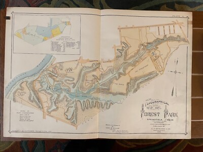
$15.00 Shipping Location: Orange, United States Normal 0 false false false EN-US JA X-NONE 1899 Antique Atlas Hand Colored Topographical Map Forest Park Springfield MA Removed from an 1899 City of Springfield ... moreMA Atlas Published in Springfield. MA by J L Richards. Printed on lightly coated period linen( backed paper as issued which retains its inherent structural flexibility and soundness; has detailed park features such as Pecousic Villa(Everett Barney’s home) King Phillips Indian Stockade, Aquatic Gardens, Lotus Pond, Skating Pond, The Playground, Deer Preserve, Swan Pond, Children’s Paddle Pond, Bear Pit, Menagerie Building, the mysterious“Dean Massacre” site, etc. Shows original road network(now substantially changed) shows location of the Pecousic railroad station where day visitors got on and off the train. Shows the sources of the park land by gift and purchase including land from famous local families: Barney. Chapin, Southworth, McKnight, Wesson, Merriam, and Stebbins Most individual buildings then existing are clearly visible as structures; old(and many now changed) street names are shown This scarce old map has been nicely beautifully printed and lithohraphed on an oversized folio sheet. Allowing for a reliable and precise detailed rendering In VERY GOOD/ EXCELLENT condition: displays normal minor light age toning. Staining or foxing; overall the map remains very clean and very displayable. Please note: the lighting for the photos is terrible. The photos make this look there is lots of staining. Especially down the centerline fold but that is not the case. This displays beautifully in person. Note the zoom feature which allows for very close inspection. Minor defects along the sheet edges and corners do not detract. Super old printed paper map entirely worthy of any collection and/ or display. A cartographic depiction captured in a manner entirely unique to this particular historical era. Not only is the artistic style interesting. But the historical method used for printing it essentially no longer exists. This renders the sheet of pape
Buy It Now
$30.70 Shipping Location: Jacksonville, United States This antique county map from 1882 depicts Florida and the Keys in exquisite detail. The map is hand colored and framed, frame and matted behind glass ... moremeasuring overall 23x19 inches.the map measures 11 by 15 Created by Bradley, this antique original is a rare find for collectors of North American maps, and would make a beautiful addition to any home or office. The map's date range falls between 1800-1899 and its format is a sheet map. It is categorized under North America Maps, Maps, Atlases & Globes, and Antiques. The map depicts Florida in the United States of America and is a must-have for anyone interested in antique county state maps.
|
|
|
In
|
North Part of St. Louis Co., MN original 1899 Geological & Natural History Map
North Part of St. Louis Co. MN original 1899 Geological& Natural History Map http:www.auctiva.com/stores/viewstore.aspx WELCOME TO THE HOUSE OF TIME. THIS IS A 112 YEAR-OLD MAP TAKEN FROM A DAMAGED BOOK THAT WAS PRINTED IN 1899 AND BEING SALVAGED FOR ITS BETTER PARTS. THE MAP HAS BEEN WELL PROTECTED FROM FADING AND IN IS IN EXCELLENT CONDITION. THERE IS NO MOISTURE DAMAGE. FOXING OR ANY ODOR. IT WILL FIT IN A 12 INCH BY 18 INCH FRAME VERY NICELY. I HAVE SHOWN IT ABOVE WITH A 12 INCH WOOD RULER FOR SCALE. ONE IMAGE WAS MADE WITH A SCANNER AND THE OTHER WITH A CAMERA. IT HAS A TYPICAL REINFORCED FOLD AND LAYS NICE AND FLAT. ENLARGE THE IMAGES FOR A BETTER LOOK. for more Minnesota County maps and other historical paperwork. There is no extra charge for combined shipping. ALWAYS BUYING AND LIQUIDATING QUALITY COLLECTIONS AND ESTATES.
|
|
|
Duluth Minnesota Street Map: Authentic 1899; shows Harbor; Landmarks, More
1899 Large Color: Duluth. Minnesota Street Map/ Plan(This map is 110+ years old- NOT a Reproduction- Scan of Atlas Copyright Page below) This is a LARGE map. Printed on a single sheet with a fold in the center. Bordered map area is about 19" x 13" and the map has sufficient margins for matting or framing. Too big for my scanner so scanned in two passes. Resulting scans were then electronically merged. There is NO break in the center of the map. There is a fold. A laser-printed facsimile of the copyright information as it appears in the atlas from which this original map was removed will be included. On a peel-off. Self-adhesive sheet. Purchasers who frame their maps frequently affix that copyright statement to the back of the frame. No break in the map; printed on a single sheet with a fold in the center. Scanned in two passes on ... morea tabloid sized scanner and the two scans combined electronically. This color map of Duluth was taken from an 1899 Cram's atlas published in Chicago by George Cram. Shows streets. Railroads, stations and switch yards; along with parks and important landmarks. Close-up detail below. The map is printed on medium weight paper. And is in very good condition-as shown. Bid with confidence- Returnable for any reason within 10 days for prompt refund. Powered by The free listing tool. List your items fast and easy and manage your active items.
|
|
|
MINNESOTA Map: Authentic 1899; Counties, Cities, Railroads, Topography
1899 Large Color Map Minnesota This is a 100+ Year-Old Map- NOT a Reproduction(Scan of Atlas Copyright Page below) Printed on a single sheet with a fold in the center. Bordered map size is about 13.5" x 20" with margins sufficient to allow matting or framing-pictured below without the full margins to allow image to load a little quicker. Too big for my large scanner so scanned in two passes and then combined for the image below. A laser-printed facsimile of the copyright information as it appears in the atlas from which this original map was removed will be included. On a peel-off. Self-adhesive sheet. Purchasers who frame their maps frequently affix that copyright statement to the back of the frame. No break on map-scanned in two passes on a large scanner! This color map of Minnesota was taken from a Cram Atlas with 1899 on the ... morecopyright page and 1900 on the title page. Much of the Census material throughout the atlas appears to be from the 1900 Census. But there is some data which has NOT been updated from the 1890 Census. The maps undoubtedly represent conditions as they existed in 1895 to 1899. Principal railroads are shown and labeled. Many of these roads are now defunct while some are still being used-operated by original proprietors or by their successors. Clear demarcation of county borders and a very thorough inclusion of Cites. Town, and even many small Villages. The close-up below shows the area surrounding the Twin Cities and is included to give an example of the detail and quality of this map. The map is printed on medium weight paper. And is in very good condition-as shown. Bid with confidence- Returnable for any reason within 10 days for prompt refund. Powered by The free listing tool. List your items fast and easy and manage your active items.
|
|
|
Antique Norman County Ada Minnesota Red River Valley Real Estate Sale Map c.1899
Click to Enlarge Click to Enlarge Click to Enlarge Click to Enlarge Click to Enlarge This is an original antique fold out real estate sale map of Norman County. Minnesota which is not dated but looks to be a late 19th century or perhaps circa 1900 piece. The front cover panel reads: John Grove Land& Loan Company- Ada. Minn. County Seat of Norman County, The Famous Red River Valley- Call on my Agents Everywhere or Write to me for Reduced Rates of Transportation- Real Estate and Farm Print, Morris, Minn. This map folds out to about 18" x 15" with the map printed on one side and photos and descriptive information about Norman County and the land for sale on the verso. The map is platted out with numbered lots and titled: Map of Norman County- Compliments of John Grove Land& Loan Company. Ada, Minnesota- The Famous Red River ... moreValley This map shows the towns of Ada. Shely, Halstad, Hendrum, Perley, Borup, Twin Valley and others as well as some lakes, post offices, railroad lines and more. This map is an original antique which I believe was published around 110 years ago. The map is folded as issued and has a small spot with insect damage which when folded out leaves four small areas with some insect damage. The areas with insect damage are small and the map is otherwise in good shape. Please see the photos and email any questions. If you are not satisfied with the condition of the map please contact me for a refund within 14 days. Thanks for looking. Payment Terms Winning bidders will receive an email at the end of the auction explaining the option for paying with Paypal. If you have questions about how to pay for this item please let me know. If you made multiple purchases for a single shipment contact us for combined shipping charges which will normally be less than the amount shown on Paypal invoice. You will receive an email notifying you when your item ships. Buyers outside the USA. Please provide a telephone number for customs forms. Shipping Terms Please click on the Shipping& Payment tab a
|
|
|
SOUTH DAKOTA Map: Authentic 1899; Counties, Cities, Towns, RRs, Topography
1899 Large Color Map South Dakota This is a 100+ Year-Old Map- NOT a Reproduction(Scan of Atlas Copyright Page below) Printed on a single sheet with a fold in the center. Bordered map size is about 19.75" x 13.5" with margins sufficient to allow matting or framing-pictured below without the full margins to allow image to load a little quicker. Too big for my large scanner so scanned in two passes and then combined for the image below. A laser-printed facsimile of the copyright information as it appears in the atlas from which this original map was removed will be included. On a peel-off. Self-adhesive sheet. Purchasers who frame their maps frequently affix that copyright statement to the back of the frame. No break on map-scanned in two passes on a large scanner! This color map of South Dakota was taken from a Cram Atlas with 1899 ... moreon the copyright page and 1900 on the title page. Much of the Census material throughout the atlas appears to be from the 1900 Census. But there is some data which has NOT been updated from the 1890 Census. The maps undoubtedly represent conditions as they existed in 1895 to 1899. Principal railroads are shown and labeled. Many of these roads are now defunct while some are still being used-operated by original proprietors or by their successors. Clear demarcation of county borders and a very thorough inclusion of Cites. Town, and even many small Villages. The close-up below shows the area surrounding Deadwood and Sturgis. And is included to give an example of the detail and quality of this map. The map is printed on medium weight paper. And is in very good condition-as shown. Bid with confidence- Returnable for any reason within 10 days for prompt refund. Powered by The free listing tool. List your items fast and easy and manage your active items. RcmdId ViewItemDescV4,RlogId p4%60bo7%60jtb9%3Fuk%601d72f%2Bi%3Ahtpqto%3E%7B-13d20384bfe-0xfd-
|
|
|
WYOMING Map: Authentic 1899; Counties, Cities, Towns, RRs, Topography
1899 Large Color Map Wyoming This is a 100+ Year-Old Map- NOT a Reproduction(Scan of Atlas Copyright Page below) Printed on a single sheet with a fold in the center. Bordered map size is about 19.5" x 13.5" with margins sufficient to allow matting or framing-pictured below without the full margins to allow image to load a little quicker. Too big for my large scanner so scanned in two passes and then combined for the image below. A laser-printed facsimile of the copyright information as it appears in the atlas from which this original map was removed will be included. On a peel-off. Self-adhesive sheet. Purchasers who frame their maps frequently affix that copyright statement to the back of the frame. No break on map-scanned in two passes on a large scanner! This color map of Wyoming was taken from a Cram Atlas with 1899 on the copyright ... morepage and 1900 on the title page. Much of the Census material throughout the atlas appears to be from the 1900 Census. But there is some data which has NOT been updated from the 1890 Census. The maps undoubtedly represent conditions as they existed in 1895 to 1899. Principal railroads are shown and labeled. Many of these roads are now defunct while some are still being used-operated by original proprietors or by their successors. Clear demarcation of county borders and a very thorough inclusion of Cites. Town, and even many small Villages. The close-up below shows the area surrounding Cheyenne and is included to give an example of the detail and quality of this map. The map is printed on medium weight paper. And is in very good condition-as shown. Bid with confidence- Returnable for any reason within 10 days for prompt refund. Powered by The free listing tool. List your items fast and easy and manage your active items.
|
|
|
1899 Walker's/Cram's Railroad Map of Minnesota. Hand colored. Genuine.
This is a large 1899 Railroad Map of Minnesota. It measures 25 X 17 inches. This map has listed the railroad companies along with the area in which they cover. See scan's below) Only known copy A search of worldcat.org and all dealers stocks on the internet found no other copy of this 1899 Walker's map or the atlas that it was taken from. Walker's International Atlas" The base map was from Cram's Railway Atlas. But the plates were used to create this outstanding work of art by hand coloring the counties. The only way to properly describe the colors is compare them with Easter egg dye. This map does have a few minor handling flaws. And shows age on the edges. We take special care in shipping these maps as there are no replacements. Seriously doubt if we'll ever see another in our lifetime. Compare our low price for ... morethis map with similar offered by the largest map dealer in the United States. Murray-Hudson whom can be found through google. Better yet, check out how much and how rare a map is from just a Cram's Railway Atlas using Google. Railroads found on this map. Thumbnail view of map showing railroads and close up of the hand coloring.
|
|
|
Original 1899 Map YELLOWSTONE NATIONAL PARK Wyoming Geyser Basin Firehole Hotel
Original 1899 Map YELLOWSTONE NATIONAL PARK Wyoming Geyser Basin Firehole Hotel Handsome original antique color lithographed map of Yellowstone National Park. Printed more than 113 years ago. The map has good detail of the terrain in our nations' first national park. With topography shown in relief. It labels the continental divide, Yellowstone Lake, Geyser Basin, Pitchstone Plateau, Fossil Forests, Mount Washburn, Sheepeater Creek, Shoshone Lake, and other natural features. Among the other named places and features on the map are the Riverside Mail Station. Firehole Hotel, Camp Reunion, Gamekeeper's Cabin, Park Headquarters, Baronettes Bridge, Old Ruin, Storm Point Indian Camp, and more. Longitude is measured from Greenwich and Washington. The scans below give a closer look at some of the detail: This map was published by George ... moreFranklin Cram of Chicago in 1899. And the image area measures 11-1/2" x 9-1/2" This is an original. Authentic antique map, not a reproduction or modern reprint. And it is fully guaranteed to be genuine. It would make a handsome display in your den or office. It would also make a perfect gift, and we'll include our helpful framing tips for your reference, along with a photocopy of the dated title page from the book in which it was published. Condition: This map is in very good condition. Bright and clean, with no marks, rips, or tears. We are pleased to offer it with our unconditional. Money-back guarantee. SHIPPING: We gladly ship anywhere in the World. And we use sturdy, professional packing materials to assure safe delivery. The shipping charges are as follows: Within the United States. Including Alaska, Hawaii, and APO addresses: $4.59 To Canada or Mexico: $9.99 To all other international destinations: $14.29(These charges reflect recent increases made by the United States Postal Service for international delivery. We will appreciate your prompt payment for this item. If you need more time or have any other questions about making your payment. Or if you may desir
|
|
|
Original 1899 Map INDIAN Land Cessions in MINNESOTA 35
Auction Wizard 2000 Listing Template- AW2KLOT#4906 tincuptom Auctions Original 1899 Map INDIAN Land Cessions in MINNESOTA 35 Over 113 years old. Original 1899 Beautiful. Double-page map from the official records, not a later reprint. Map published by the Bureau of American Ethnology Excellent Condition Land Cessions of the Chippewa Indians in MINNESOTA. Each Land Cession has a number on the map. Each number corresponds to a full explanation compiled by Charles C. Royce and that information will accompany the map. There are 6 Land Cessions from 1889 to 1892. The double-page. Tipped-in map measures approximately 11 1/4 x 14 1/2 inches. No printing on the backside. Shipped folded as issued. The USA Shipping is First Class mail. View my other listings for more antiques. Shipping and handling in the USA is $0.00. Payments are due in 7 day. You ... moremay pay by Paypal only. Please E-mail for International Shipping rates.
|
|
|
MONTANA Map: Authentic 1899; Counties, Cities, Towns, Railroads, Topography
1899 Large Color Map Montana This is a 100+ Year-Old Map- NOT a Reproduction(Scan of Atlas Copyright Page below) Printed on a single sheet with a fold in the center. Bordered map size is about 18.5" x 12.25" with margins sufficient to allow matting or framing-pictured below without the full margins to allow image to load a little quicker. Too big for my large scanner so scanned in two passes and then combined for the image below. A laser-printed facsimile of the copyright information as it appears in the atlas from which this original map was removed will be included. On a peel-off. Self-adhesive sheet. Purchasers who frame their maps frequently affix that copyright statement to the back of the frame. No break on map-scanned in two passes on a large scanner! This color map of Montana was taken from a Cram Atlas with 1899 on the ... morecopyright page and 1900 on the title page. Much of the Census material throughout the atlas appears to be from the 1900 Census. But there is some data which has NOT been updated from the 1890 Census. The maps undoubtedly represent conditions as they existed in 1895 to 1899. Principal railroads are shown and labeled. Many of these roads are now defunct while some are still being used-operated by original proprietors or by their successors. Clear demarcation of county borders and a very thorough inclusion of Cites. Town, and even many small Villages. The close-up below shows the area surrounding Helena and is included to give an example of the detail and quality of this map. The map is printed on medium weight paper. And is in very good condition-as shown. Bid with confidence- Returnable for any reason within 10 days for prompt refund. Powered by The free listing tool. List your items fast and easy and manage your active items.
|
|
|
Rare Antique 1899 US Idaho Wyoming Yellowstone National Park Map
1899 Idaho and Wyoming. Yellowstone National Park Map Note: My camera takes terrible pictures. So I scanned part of the map so you could see it up close and also see the true colors. Item: This is a rare. 113 year old, authentic 1899 map. It is NOT a reproduction. Book Title: The Century Atlas of the World" Publisher: The Century Co. New York 1899 Size: Approx. 16" x 11 3/4" Engravings: Maps specially engraved for the Century Co. by The Matthews-Northrup Co. Buffalo. NY COA: You will receive a copy of the title page and copyright page from the original book to show authenticity. Condition: This is a two page map and does contain the original fold line in the middle. Please note that I am not an expert in judging the condition of antique maps. See scan for condition and if you have any questions. Please let me know. Shipping: ... moreI am always happy to combine shipping when I can. Please just wait for an invoice if you purchase more than one item. I always do my best to save you as much as I can on shipping costs. Refund policy: I offer a lifetime. No questions asked refund. If you are unhappy with your purchase, simply return it for a full refund. It's that simple. For my international customers: You will be responsible for any import taxes. Duties, or custom charges that may by required by your country. Those costs are not included in the price of this item. On Mar-18-13 at 03:34:29 PDT. Seller added the following information: Every buyer gets a MyStoreRewards invitation for cash back
|
|
|
Aitkin Co.,Minnesota original 1899 9.25"x12.5" Geological & Natural History Map
Aitkin Co.Minnesota original 1899 9.25"x12.5" Geological& Natural History Map Search WELCOME TO THE HOUSE OF TIME. THIS IS A HARD TO FIND 112 YEAR-OLD MAP TAKEN FROM A DAMAGED BOOK THAT WAS PRINTED IN 1899 AND BEING SALVAGED FOR ITS BETTER PARTS. THE MAP HAS BEEN WELL PROTECTED FROM DAMAGE AND FADING AND IS IN EXCELLENT CONDITION. THERE IS NO MOISTURE DAMAGE. FOXING OR ANY ODOR. IT WILL FIT IN A 12 INCH BY 9 INCH FRAME OR MATT VERY NICELY. ENLARGE THE IMAGE FOR A BETTER LOOK. IT WILL BE SHIPPED TO YOU BETWEEN TWO PIECES OF STURDY CARDBOARD. for more Minnesota County maps and other historical paperwork. There is no extra charge for combined shipping. ALWAYS BUYING AND LIQUIDATING QUALITY COLLECTIONS AND ESTATES.
|
|
|
Antique Map United States Montana Map Engraving 1899
1899 MONTANA MAP Note: My camera takes terrible pictures. So I scanned part of the map so you could see it up close and also see the true colors. Item: This is a rare. 113 year old, authentic 1899 map. It is NOT a reproduction. Book Title: The Century Atlas of the World" Publisher: The Century Co. New York 1899 Size: Approx. 16" x 11 3/4" Engravings: Maps specially engraved for the Century Co. by The Matthews-Northrup Co. Buffalo. NY COA: You will receive a copy of the title page and copyright page from the original book to show authenticity. Condition: This is a two page map and does contain the original fold line in the middle. Please note that I am not an expert in judging the condition of antique maps. See scan for condition and if you have any questions. Please let me know. Shipping: I am always happy to combine shipping ... morewhen I can. Please just wait for an invoice if you purchase more than one item. I always do my best to save you as much as I can on shipping costs. Refund policy: I offer a lifetime. No questions asked refund. If you are unhappy with your purchase, simply return it for a full refund. It's that simple. For my international customers: You will be responsible for any import taxes. Duties, or custom charges that may by required by your country. Those costs are not included in the price of this item. On Mar-18-13 at 03:42:12 PDT. Seller added the following information: Every buyer gets a MyStoreRewards invitation for cash back o`7.RcmdId ViewItemDescV4,RlogId p4%60bo7%60jtb9%3Fuk%601d72f%2B6mwimiu%3Eo%607-13eb7aa9ac5-0xf1-
|
|
|
NORTH DAKOTA Map: Authentic 1899; Counties, Cities, Towns, Railroads, Topog
1899 Large Color Map North Dakota This is a 100+ Year-Old Map- NOT a Reproduction(Scan of Atlas Copyright Page below) Printed on a single sheet with a fold in the center. Bordered map size is about 13.5" x 20" with margins sufficient to allow matting or framing-pictured below without the full margins to allow image to load a little quicker. Too big for my A laser-printed facsimile of the copyright information as it appears in the atlas from which this original map was removed will be included. On a peel-off. Self-adhesive sheet. Purchasers who frame their maps frequently affix that copyright statement to the back of the frame. No break on map-scanned in two passes on a large scanner! This color map of North Dakota was taken from a Cram Atlas with 1899 on the copyright page and 1900 on the title page. Much of the Census material ... morethroughout the atlas appears to be from the 1900 Census. But there is some data which has NOT been updated from the 1890 Census. The maps undoubtedly represent conditions as they existed in 1895 to 1899. Principal railroads are shown and labeled. Many of these roads are now defunct while some are still being used-operated by original proprietors or by their successors. Clear demarcation of county borders and a very thorough inclusion of Cites. Town, and even many small Villages. The close-up below shows the area surrounding Carrington and is included to give an example of the detail and quality of this map. The map is printed on medium weight paper. And is in very good condition-as shown. Bid with confidence- Returnable for any reason within 10 days for prompt refund. Powered by
|
|
|
1899: WYOMING, WY. COUNTIES, ROADS, RESERVATIONS. ORIGINAL ANTIQUE STATE MAP.
1899 MAP: WYOMING FROM: RAND McNALLY& CO.s UNIVERSAL ATLAS OF THE WORLD. PUBLISHED 1899. CHICAGO& NEW YORK. Size: Approx 11 X 14 INCHES(ENTIRE PAGE) IMAGE SIZE A LITTLE SMALLER. Condition: VERY GOOD. SEE PHOTO. Please view the photos to make your own assessment. Returns: Any item may be returned for a refund. Please contact us within 7 days of receipt of your item if you feel an error has been made. We do not deal in modern reproductions. All of our maps are original and authentic. inkfrog terapeak. I000000.
|
|
|
Minnesota Pine Regions 1899. Color map
Minnesota Pine Regions 1899.Color map This is an 1899 original map titled: Pine Region of Minnesota. Showing distribution of lands. The map covers all of Minnesota north of about 45 degrees 45 minutes. The map legend has seven categories of land cover: Prairie; Brush Prairie; Hardwood; Original Forest Pine less than 2000 Feet B.M. Original Forest Pine 2000- 5000 Feet B.M. Pine Cut 90 per cent Burned Over; Burned Before Cutting. A very large area was burned over. This is not a map removed from a bound atlas. Or a book, but rather a very large 47 by 34 inch sheet map showing data from 1899 and published by the U.S. Geological Survey in 1900. The map is folded to about 7 by 11 inches. The scale is about 1:500,000(1 inch = 8 miles) It was published by the U.S. Geological Survey and“Compiled under the direction of Henry Gannett. Geographer In ... moreCharge, By H.B. Ayres, 1899. My scanner bed is too small to show the entire map. I have given a small section of the map to show the detail given on the map. The section is on the southeast edge of the map. And shows the very large extent of burned areas. Images of the front and back of the folded map are posted to show condition. This is an original printed map from 1899. Not a reproduction. This large map would make a great display item. Its reference value is enormous as this is the first professional survey of this forest. And shows in some detail the extent of burnt over forest at the period when the National Forests were being established. This is a rare map, only found now in research libraries. This map is Plate CXLIII from the U.S. Geological Survey publication: Twenty-First Annual Report 1899-1900 Part V Forest Reserves- Maps. It was issued folded to fit the size of the Report volumes. This map does NOT include the article titled“Timber Conditions of the Pine Region of Minnesota” by H.B. Ayres, which is in Volume V of the 1900 Report. The map is in Very Good condition. The map face is excellent. But there is a small spot of black in one corner that does
|
|
|
SUPERB ANTIQUE 1899 NEBRASKA NORTH DAKOTA COLOR LITHOGRAPHED MAP DETAILED FINE N
Click Here. Double your traffic. Get Vendio Gallery- Now FREE! Fine antique 1899 color lithographed 2 sided map. Either side would frame and display nicely. One side is Nebraska, reverse is North Dakota. Both are dated 1899 at bottom. Very detailed, fine attractive period maps of these areas at this time. The size is 9" by 12" Rare. Winning bidder pays $3.00 shipping domestic, more foreign. Payment I accept the following forms of payment: PayPal Click to View Image Album Click to View Image Album Shipping& Handling US Shipping. $3.00 USPS First-Class Mail® International Shipping. $9.00 USPS First-Class Mail International FREE scheduling. Supersized images and templates. Get Vendio Sales Manager. FREE scheduling. Supersized images and templates. Get Vendio Sales Manager.
|
|
|
1899 color map SW Black Hills water sandstone
1899 color map SW Black Hills water sandstone This is an original map titled: Map Showing Distribution of Water in the Dakota and Underlying Sandstones in the region adjoining the Black Hills on the Southwest. By N.H. Darton. 1899. This is an 11 ¼ by 19 inch sheet map published by the U.S. Geological Survey in the 1899-1900 Annual report. The scale of the map is about 1:250,000. The map is about 9 ¾ by 17 ¼ inches on a sheet about 11 ¼ by 19 inches. Folded to about 6 ½ by 11 ¼ inches. This map is Plate XCVII(97) from the U.S. Geological Survey publication: Twenty-First Annual Report 1899-1900 Part IV. It was issued folded and bound into the report volume. This map covers the part of the south west corner of the Black Hills Forest Reserve and the adjacent region. The south edge of the map is at 43 degrees and ... morethe north edge at 44 degrees. The104 degree line runs north/south in the right center of the map. The area covered is about 36 by 70 miles in extent. Some of the towns marked on the map are: Pedro. Cambria, Newcastle, Spencer, Clifton, S& G Ranch; Argentine, Marietta, and Edgemont. This is a topographic map with Railroads. Creek names, Towns, and Township and Range markers. Creeks with running water and those that are dry water courses in the Summer are marked. This map is overprinted with patterns that show depth to Dakota Sandstone; outcrops of Dakota Sandstone; Minneluse Sandstone; and artesian areas. This large map would make a great display item. This is a rare map. Only found now in research libraries. My scanner bed is too small to show the entire map. But see the image of about 60% of the map to show the detail level of the map. Also an image of the folded map is posted to show condition. It is in very good condition. It would be fine but is a little worn by being unfolded several times. The map was mounted on a mounting strip that was bound into the book. And the map has been cut from the book by cutting the mounting strip. On the back“97” is printed and“Dakota’ is w
|
|
|
1899 color map SE Black Hills water sandstone
1899 color map SE Black Hills water sandstone This is an original map titled: Map Showing Distribution of Water in the Dakota and Underlying Sandstones in the region adjoining the Black Hills on the Southeast. By N.H. Darton. 1899. This is an 11 ¼ by 19 ½ inch sheet map published by the U.S. Geological Survey in the 1899-1900 Annual report. The scale of the map is about 1:250,000 and the contour interval is 100 feet. The map is about 9 ½ by 17 ¾ inches on a sheet about 11 ¼ by 19 ½ inches. Folded to about 6 ½ by 11 ¼ inches. This map is Plate XCVI(96) from the U.S. Geological Survey publication: Twenty-First Annual Report 1899-1900 Part IV. It was issued folded and bound into the report volume. This map covers the part of the south east corner of the Black Hills Forest Reserve and the adjacent region. ... moreThe south edge of the map is at 43 degrees and the north edge at 44 degrees. The103 degrees 30 minutes line runs north/south in the left center of the map. The area covered is about 36 by 70 miles in extent. Some of the towns marked on the map are: Hayward. Hermosa, Fairburn, Hot Springs, Buffalo Gap, Pringle, Minnekahta, Odell, Maitland, Oelricks, Ramford, and Ardmore. This is a topographic map with Railroads. Creek names, Towns, and Township and Range markers. Creeks with running water and those that are dry water courses in the Summer are marked. This map is overprinted with patterns that show depth to Dakota Sandstone; outcrops of Dakota Sandstone; Minneluse Sandstone; and artesian areas. This large map would make a great display item. This is a rare map. Only found now in research libraries. My scanner bed is too small to show the entire map. But see the image of about 60% of the map to show the detail level of the map. Also an image of the folded map is posted to show condition. It is in very good condition. It would be fine but is a little worn by being unfolded several times. The map was mounted on a mounting strip that was bound into the book. And the map has been cut
|
|
|
1899 MAP AJAX MINE, TINTIC DISTRICT, JUAB UTAH. PLAN OF ORE BODIES. BIEN LITHO.
1899 ANTIQUE MAP: AJAX MINE. TINTIC DISTRICT, JUAB UTAH. PLAN OF ORE BODIES. BIEN LITHOGRAPH. PUBLISHED BY THE GOVERNMENT PRINTING OFFICE. WASHINGTON, DC. IN 1899. Size: Approx 11.25 X 7.5 INCHES(ENTIRE SHEET) ANTIQUE LITHOGRAPH MAP FROM THE LATE 19TH CENTURY. Condition: VERY GOOD. SEE PHOTO. Please view the photos to make your own assessment. Returns: Any item may be returned for a refund. Please contact us within 14 days of receipt of your item if you feel an error has been made. We do not deal in modern reproductions. All of our prints& maps are original and authentic. Please browse other prints& maps at our store. Inv# 13-9-M inkfrog terapeak. I000000.
|
|
|
1899 MAP OF MIDLOTHIAN DISTRICT RICHMOND COAL FIELD VIRGINIA VA. HOEN LITHOGRAPH
1899 ANTIQUE MAP OF A PORTION OF THE MIDLOTHIAN DISTRICT. RICHMOND COAL FIELD. LITHOGRAPHY BY A. HOEN& CO, BALTIMORE. PUBLISHED BY THE GOVERNMENT PRINTING OFFICE. WASHINGTON, DC. IN 1899. Size: Approx 11.25 X 14.25 INCHES(ENTIRE SHEET) ANTIQUE LITHOGRAPH MAP FROM THE LATE 19TH CENTURY. Condition: VERY GOOD. SEE PHOTO. Please view the photos to make your own assessment. Returns: Any item may be returned for a refund. Please contact us within 14 days of receipt of your item if you feel an error has been made. We do not deal in modern reproductions. All of our prints& maps are original and authentic. Please browse other prints& maps at our store. Inv# 13-9-M inkfrog terapeak. I000000.
|
|
|
1899 MAP HAY CREEK REGION, CROOK COUNTY WYOMING WY.BLACK HILLS. HOEN LITHOGRAPH
1899 ANTIQUE MAP: GEOLOGICAL MAP OF THE HAY CREEK REGION OF THE BLACK HILLS. CROOK COUNTY WYOMING SHOWING PLANT LOCALITIES. MAP PREPARED BY WALTERP. JENNEY, LITHOGRAPHY BY A. HOEN& CO, BALTIMORE. DATED 1898. PUBLISHED BY THE GOVERNMENT PRINTING OFFICE. WASHINGTON, DC. IN 1899. Size: Approx 11.25 X 9.25 INCHES(ENTIRE SHEET) ANTIQUE LITHOGRAPH MAP FROM THE LATE 19TH CENTURY. Condition: VERY GOOD. SEE PHOTO. Please view the photos to make your own assessment. Returns: Any item may be returned for a refund. Please contact us within 14 days of receipt of your item if you feel an error has been made. We do not deal in modern reproductions. All of our prints& maps are original and authentic. Please browse other prints& maps at our store. Inv# 13-9-M inkfrog terapeak. I000000.
|
|
|
1899 MAP BLACKHAWK, BLACK HILLS SOUTH DAKOTA. CYAD & ATLANTOSAURUS BEDS. LITHO
1899 ANTIQUE MAP: THE BLACKHAWK REGION OF BLACK HILLS SOUTH DAKOTA SHOWING THE CYAD AND THE ATLANTOSAURUS BEDS. MAP BY LESTER F. WARD. LITHOGRAPHY BY A. HOEN& CO, BALTIMORE. DATED 1898. PUBLISHED BY THE GOVERNMENT PRINTING OFFICE. WASHINGTON, DC. IN 1899. Size: Approx 11.25 X 9.25 INCHES(ENTIRE SHEET) ANTIQUE LITHOGRAPH MAP FROM THE LATE 19TH CENTURY. Condition: VERY GOOD. SEE PHOTO. Please view the photos to make your own assessment. Returns: Any item may be returned for a refund. Please contact us within 14 days of receipt of your item if you feel an error has been made. We do not deal in modern reproductions. All of our prints& maps are original and authentic. Please browse other prints& maps at our store. Inv# 13-9-M inkfrog terapeak. I000000.
|
|
|
1899: GEOLOGICAL MAP, BLACK HILLS SOUTH DAKOTA SD. LITHOGRAPH: BY A. HOEN & Co.
1899 ANTIQUE MAP: GEOLOGICAL SKETCH MAP OF THE BLACK HILLS OF DAKOTA SD. A. HOEN& CO. BALTIMORE. PUBLISHED BY THE GOVERNMENT PRINTING OFFICE. WASHINGTON, DC. IN 1899. Size: Approx 11.25 X 14.25 INCHES(ENTIRE SHEET) EXCEPTIONAL ANTIQUE LITHOGRAPH MAP FROM THE LATE 19TH CENTURY. Condition: VERY GOOD. SEE PHOTO. Please view the photos to make your own assessment. Returns: Any item may be returned for a refund. Please contact us within 14 days of receipt of your item if you feel an error has been made. We do not deal in modern reproductions. All of our prints& maps are original and authentic. Please browse other prints& maps at our store. Inv# 13-9-M inkfrog terapeak. I000000.
|
|
|
1899 Antique SOUTH DAKOTA Map Vintage State Map 1800's Atlas Map
Be sure to add me to your! This is an original. Not reproduction, vintage map of Sou th Dakota which was carefully removed from an atlas. There is surrounding border and index beyond the map. This map measures approximately 1 2" by 9" and is in very good condition. Your item will be packaged in a plastic sleeve. With a thin piece of backing, then in a manila envelope with a very stiff and thick piece of cardboard or in a cardboard mailing tube. We happily combine purchases to save on shipping fees. Please email with questions. We will answer your email promptly! Please visit our ebay store. Plaindealing Vintage Paper. We have stocked it with thousands of vintage advertisements, prints, and historical articles. Check out my! Powered by The free listing tool. List your items fast and easy and manage your active items.
|
|
|
Rove Lake, Minnesota original 1899 9.25"x12.5" Geological & Natural History Map
Rove Lake. Minnesota original 1899 9.25"x12.5" Geological& Natural History Map WELCOME TO THE HOUSE OF TIME. ROVE LAKE PLATE. BY U.S.GRANT. THIS IS A HARD TO FIND 112 YEAR-OLD MAP TAKEN FROM A DAMAGED BOOK THAT WAS PRINTED IN 1899 AND BEING SALVAGED FOR ITS BETTER PARTS. THE MAP HAS BEEN WELL PROTECTED FROM DAMAGE AND FADING AND IS IN EXCELLENT CONDITION. THERE IS NO MOISTURE DAMAGE. FOXING OR ANY ODOR. IT WILL FIT IN A 12 INCH BY 9 INCH FRAME OR MATT VERY NICELY. IT SHOWS WAGONROADS AND TRAILS OF THAT TIME IN HISTORY. ENLARGE THE IMAGE FOR A BETTER LOOK. IT WILL BE SHIPPED TO YOU BETWEEN TWO PIECES OF STURDY CARDBOARD. for more Minnesota County maps and other historical paperwork. There is no extra charge for combined shipping. ALWAYS BUYING AND LIQUIDATING QUALITY COLLECTIONS AND ESTATES. On May-02-13 at 20:43:30 PDT. Seller ... moreadded the following information:
|
|
|
1899 Maury COLOR MAP/ CENTRAL STATES, NORTHERN DIVISION
THIS ITEM IS A GENUINE ORIGINAL VINTAGE MAP FROM THE SOURCE/DATE LISTED Name of Map- Central States. Northern Division Date- 1899 Source- Maurys Manual Geography. A treatise on mathematical, physical, and political geography Publisher- Universal Publishing Co. New York Comments- reverse contains unrelated text Size- about 12x18.25" Double page Condition- soiling. Corner wear, some light edge darkening Yes! We Do Combine Shipping on Multiple Purchases! NO RESERVE! Happy Bidding! Buyer pays shipping/packing. We use very secure packaging methods and materials. And all shipments within the United States will be made with the protection of the new USPS Parcel shipping category. First Class or Priority. Depending on weight) Note that certain items may be shipped in the USPS Media Mail category. If appropriate. Payment due within 14 days after ... moreour initial after auction contact. Pennsylvania residents MUST add applicable SALES TAX or send resale number. Thanks. Good Luck! To See Our Other Auctions and Store Items CLICK HERE! Powered by.RcmdId ViewItemDescV4,RlogId p4%60bo7%60jtb9%3Fvo%7B2d71f%2Bb41%3E-14189905b22-0xfe-
|
|
|
1899 Minnesota Antique Color Atlas Map** Indexed w/ Population.. Colorado back
1899 Minnesota Antique Color Atlas Map* Indexed w/ Population. Colorado back Gorgeous. Original 1899 Minnesota Antique Color Atlas Map. Colorado map on back This is an ORIGINAL.NOT A REPRINT. 124 +++ year-old Undated atlas map.The total size of the map including the borders measures 11 1/2" x 14 1/2"and would look wonderful matted and framed. The map is indexed on the side border where it lists Counties and chief towns and cities with their respective populations; The map shows towns and cities. Major railroads, rivers and other geographic features, etc. Great Historic Item. NOTE CONDITION: The map has lite border and corner wear. Otherwise, it is in Nice Condition. Please see the attached photo to view the Map and a closeup section of the map. Please note that the map is too large for my scanner.also. All of the printing is much ... moreclearer than the scan illustrates, streets, etc. are Small but very clear and readable even for an old blind guy like me* U.S. Buyer pays $3.00 for shipping. 1-4 maps can be combined to save on postage. Maps are mailed in sturdy mailing tubes. NO INTERNAT IONAL SHIPPING Unless buyer contacts me first and agrees to the shipping charges.about $11.00. PLEASE READ: This is an Original 1899 Undated Atlas map. For the winning bidder. I will send a copy of the copyright page which includes the publisher and the 1899 publication date. If you have any questions about this map or any of my Ebay items.Please email me before bidding. Thanks! 0 80913 Minn99.2(C) Please Visit My Ebay Store To View My Minnesota. St. Paul, Minneapolis, Wisconsin and Other Antique Maps. Thanks For Looking! ALL INTERNATIONAL BUYERS PLEASE READ: I NO LONGER SELL TO INTERNATIONAL BUYER S due to the recent increase in U.S. postage charges. UNLESS I NTERNATIONAL BUYERS CONTACT ME FIRST AND ARE WILL ING TO PAY THE $ 10.00 MINIMUM POST AGE COST S. Thanks for your understanding!
|
|
|
Itasca Co.,Minnesota original 1899 12x18 Geological & Natural History Map
Itasca Co.Minnesota original 1899 12x18 Geological& Natural History Map http:www.auctiva.com/stores/viewstore.aspx WELCOME TO THE HOUSE OF TIME. THIS IS A 112 YEAR-OLD MAP TAKEN FROM A DAMAGED BOOK THAT WAS PRINTED IN 1899 AND BEING SALVAGED FOR ITS BETTER PARTS. THE MAP HAS BEEN WELL PROTECTED FROM FADING AND IN IS IN EXCELLENT CONDITION. THERE IS NO MOISTURE DAMAGE. FOXING OR ANY ODOR. IT WILL FIT IN A 12 INCH BY 18 INCH FRAME VERY NICELY. I HAVE SHOWN IT ABOVE WITH A 12 INCH WOOD RULER FOR SCALE. ONE IMAGE WAS MADE WITH A SCANNER AND THE OTHER WITH A CAMERA. IT HAS A TYPICAL REINFORCED FOLD AND LAYS NICE AND FLAT. ENLARGE THE IMAGES FOR A BETTER LOOK. for more Minnesota County maps and other historical paperwork. There is no extra charge for combined shipping. ALWAYS BUYING AND LIQUIDATING QUALITY COLLECTIONS AND ESTATES. On Mar-22-13 ... moreat 20:14:45 PDT. Seller added the following information: On May-02-13 at 21:10:58 PDT. Seller added the following information: di,RcmdId ViewItemDescV4,RlogId p4%60bo7%60jtb9%3Fuk%601d72f%2Bishhov%3C%3Edi-1418ebea664-0xfd-
|
|
|
Beltrami Co.,Minnesota original 1899 12x18 Geological & Natural History Map
Beltrami Co.Minnesota original 1899 12x18 Geological& Natural History Map http:www.auctiva.com/stores/viewstore.aspx WELCOME TO THE HOUSE OF TIME. THIS IS A 112 YEAR-OLD MAP TAKEN FROM A DAMAGED BOOK THAT WAS PRINTED IN 1899 AND BEING SALVAGED FOR ITS BETTER PARTS. THE MAP HAS BEEN WELL PROTECTED FROM FADING AND IN IS IN EXCELLENT CONDITION. THERE IS NO MOISTURE DAMAGE. FOXING OR ANY ODOR. IT WILL FIT IN A 12 INCH BY 18 INCH FRAME VERY NICELY. I HAVE SHOWN IT ABOVE WITH A 12 INCH WOOD RULER FOR SCALE. ONE IMAGE WAS MADE WITH A SCANNER AND THE OTHER WITH A CAMERA. IT HAS A TYPICAL REINFORCED FOLD AND LAYS NICE AND FLAT. ENLARGE THE IMAGES FOR A BETTER LOOK. for more Minnesota County maps and other historical paperwork. There is no extra charge for combined shipping. ALWAYS BUYING AND LIQUIDATING QUALITY COLLECTIONS AND ESTATES. On Mar-22-13 ... moreat 20:14:43 PDT. Seller added the following information: On May-02-13 at 21:09:55 PDT. Seller added the following information: jy.RcmdId ViewItemDescV4,RlogId p4%60bo7%60jtb9%3Fuk%601d72f%2Bkw4sjm5%3Ejy-1418ebea694-0xf3-
|
|
|
Kittson,Roseau,Marshall Co's.,MN original 1899 Geological & Natural History Map
Kittson.Roseau,Marshall Co's.MN original 1899 Geological& Natural History Map http:www.auctiva.com/stores/viewstore.aspx WELCOME TO THE HOUSE OF TIME. THIS IS A 112 YEAR-OLD MAP TAKEN FROM A DAMAGED BOOK THAT WAS PRINTED IN 1899 AND BEING SALVAGED FOR ITS BETTER PARTS. THE MAP HAS BEEN WELL PROTECTED FROM FADING AND IN IS IN EXCELLENT CONDITION. THERE IS NO MOISTURE DAMAGE. FOXING OR ANY ODOR. IT WILL FIT IN A 12 INCH BY 18 INCH FRAME VERY NICELY. I HAVE SHOWN IT ABOVE WITH A 12 INCH WOOD RULER FOR SCALE. ONE IMAGE WAS MADE WITH A SCANNER AND THE OTHER WITH A CAMERA. IT HAS A TYPICAL REINFORCED FOLD AND LAYS NICE AND FLAT. ENLARGE THE IMAGES FOR A BETTER LOOK. for more Minnesota County maps and other historical paperwork. There is no extra charge for combined shipping. ALWAYS BUYING AND LIQUIDATING QUALITY COLLECTIONS AND ESTATES. ... moreOn Mar-22-13 at 20:11:23 PDT. Seller added the following information: On May-02-13 at 21:09:39 PDT. Seller added the following information:
|
|
|
Cook Co.,Minnesota original 1899 12x18 Geological & Natural History Map
Cook Co.Minnesota original 1899 12x18 Geological& Natural History Map http:www.auctiva.com/stores/viewstore.aspx WELCOME TO THE HOUSE OF TIME. THIS IS A 112 YEAR-OLD MAP TAKEN FROM A DAMAGED BOOK THAT WAS PRINTED IN 1899 AND BEING SALVAGED FOR ITS BETTER PARTS. THE MAP HAS BEEN WELL PROTECTED FROM FADING AND IN IS IN EXCELLENT CONDITION. THERE IS NO MOISTURE DAMAGE. FOXING OR ANY ODOR. IT WILL FIT IN A 12 INCH BY 18 INCH FRAME VERY NICELY. I HAVE SHOWN IT ABOVE WITH A 12 INCH WOOD RULER FOR SCALE. ONE IMAGE WAS MADE WITH A SCANNER AND THE OTHER WITH A CAMERA. IT HAS A TYPICAL REINFORCED FOLD AND LAYS NICE AND FLAT. ENLARGE THE IMAGES FOR A BETTER LOOK. for more Minnesota County maps and other historical paperwork. There is no extra charge for combined shipping. ALWAYS BUYING AND LIQUIDATING QUALITY COLLECTIONS AND ESTATES. On Mar-22-13 ... moreat 20:11:22 PDT. Seller added the following information: On May-02-13 at 21:07:56 PDT. Seller added the following information:
|
|
|
Lake Co.,Minnesota original 1899 12x18 Geological & Natural History Map
Lake Co.Minnesota original 1899 12x18 Geological& Natural History Map http:www.auctiva.com/stores/viewstore.aspx WELCOME TO THE HOUSE OF TIME. THIS IS A 112 YEAR-OLD MAP TAKEN FROM A DAMAGED BOOK THAT WAS PRINTED IN 1899 AND BEING SALVAGED FOR ITS BETTER PARTS. THE MAP HAS BEEN WELL PROTECTED FROM FADING AND IN IS IN EXCELLENT CONDITION. THERE IS NO MOISTURE DAMAGE. FOXING OR ANY ODOR. IT WILL FIT IN A 12 INCH BY 18 INCH FRAME VERY NICELY. I HAVE SHOWN IT ABOVE WITH A 12 INCH WOOD RULER FOR SCALE. ONE IMAGE WAS MADE WITH A SCANNER AND THE OTHER WITH A CAMERA. IT HAS A TYPICAL REINFORCED FOLD AND LAYS NICE AND FLAT. ENLARGE THE IMAGES FOR A BETTER LOOK. for more Minnesota County maps and other historical paperwork. There is no extra charge for combined shipping. ALWAYS BUYING AND LIQUIDATING QUALITY COLLECTIONS AND ESTATES. On May-02-13 ... moreat 21:07:34 PDT. Seller added the following information:
|
|
|
Polk & Norman Co.,Minnesota original 1899 12x18 Geological & Natural History Map
Polk& Norman Co.Minnesota original 1899 12x18 Geological& Natural History Map http:www.auctiva.com/stores/viewstore.aspx WELCOME TO THE HOUSE OF TIME. THIS IS A 112 YEAR-OLD MAP TAKEN FROM A DAMAGED BOOK THAT WAS PRINTED IN 1899 AND BEING SALVAGED FOR ITS BETTER PARTS. THE MAP HAS BEEN WELL PROTECTED FROM FADING AND IN IS IN EXCELLENT CONDITION. THERE IS NO MOISTURE DAMAGE. FOXING OR ANY ODOR. IT WILL FIT IN A 12 INCH BY 18 INCH FRAME VERY NICELY. I HAVE SHOWN IT ABOVE WITH A 12 INCH WOOD RULER FOR SCALE. ONE IMAGE WAS MADE WITH A SCANNER AND THE OTHER WITH A CAMERA. IT HAS A TYPICAL REINFORCED FOLD AND LAYS NICE AND FLAT. ENLARGE THE IMAGES FOR A BETTER LOOK. for more Minnesota County maps and other historical paperwork. There is no extra charge for combined shipping. ALWAYS BUYING AND LIQUIDATING QUALITY COLLECTIONS AND ESTATES. ... moreOn May-02-13 at 21:05:22 PDT. Seller added the following information:
|
|
|
1899: MINNESOTA RIVER AT ST. PETER, MN. ORIGINAL ANTIQUE SKETCH MAP
Click to Enlarge Click to Enlarge 1899 LARGE ANTIQUE MAP& PLAN: DUNKIRK HARBOR ON LAKE ERIE. NEW YORK& PLANS FOR PROPOSED EAST ARM OF BREAKWATER. MAP ACCOMPANIED BY 3 PAGES OF TEXT"LETTER OF THE SECRETARY OF WAR. WITH A LETTER FROM THE CHIEF OF ENGINEERS REPORT OF EXAMINATION OF MINNESOTA RIVER, MINNESOTA. PUBLISHED BY THE GOVERNMENT PRINTING OFFICE. WASHINGTON, DC. 1899. LETTER FROM THE SECRETARY OF WAR; HOUSE OF REPRESENTATIVES DOCUMENT NO. 78, 56TH CONGRESS 1ST SESSION. Size: Approx 11.75 X 10 INCHES. Condition: VERY GOOD. SEE PHOTO. SEVERAL FOLDS. AS PUBLISHED AND BOUND INTO BOOK. Returns: Any item may be returned for a refund. Please contact us within 7 days of receipt of your item if you feel an error has been made. We do not deal in modern reproductions. All of our prints& maps are original and authentic. Please browse ... moreother prints& maps at our store. Inv# 12HDM1899 inkfrog terapeak. I000000.
|
|
|
1899 Map Sheridan WY and surrounding states Indian Military Park Reservations
1899"Map showing location of Sheridan. Wyoming, and Surrounding Reservations. 1895. This is the first year this map was published and was published in Senate Document 71, 55th Congress, 3rd Session. The map would be published again in 1900 with population figures added to the Indian Reservations and then again in 1902 with different coloring from the 1900 version. All three publications were for the building and construction of a fort at Sheridan, Wyoming. Map covers all or part of Montana, Wyoming, North Dakota, South Dakota, Nebraska, Colorado, Utah and Idaho with the then Indian Reservations, Timber Land Reserves, and National Park of those states. Railroad lines, wagon roads and major towns are included. The 1902 version is also being offered at auction at this time. The folding map size is about 13 by 17 inches. The map is in excellent ... morecondition with no tears or holes. Color is strong with colors seen from the back. Map will be shipped rolled in heavy plastic in a tube or box. Seller will pay for insurance and tracking. Questions welcome. RcmdId ViewItemDescV4,RlogId p4%60bo7%60jtb9%3Fvo%7B%3Dd70f%2Bf52%3E-1436a1eb93a-0xfc-
|
|
|
ST PAUL MN MINNESOTA authentic Antique Map genuine 115 years old made in 1899
This scan is enlarged to show representative detail. SAINT PAUL. MINNESOTA Authentic 115-Year-Old Antique Map Engraved in 1895(DATED) And printed in 1899, this is a beautiful, 115-year-old color map of the city of St. Paul Minnesota. It measures about 11 by 14 inches(about 28 by 36 cm. and is in Fine condition. The map contains a wealth of detail down to the street level, and includes routes of old railroads and horse-drawn street cars. Several old landmarks are shown, many of which are no longer in existence today. A very detailed index to streets and points of interest is printed in the margins. This is a guaranteed genuine antique map! Ideal for genealogy or historical research. This map was printed on a single sheet of stock and bound whole in an antique book. There are no folds, creases, marks or stains, and the paper is clean and not ... morebrittle. A similar map of Minneapolis is printed on the reverse. Highly suitable for framing(see sample presentation below) this map would look great in your office, library, den or study. It is similar to many of the maps sold in expensive mail-order catalogues and department stores, with one important difference: this is an actual antique. NOT a modern reproduction. An excellent investment. This map is certain to appreciate in value over time. Please ask all questions before making your purchase. SAMPLE DISPLAY IDEA SAMPLE DISPLAY IDEA FREE SHIPPING anywhere in the USA by USPS First Class Mail. Priority and Express services also available. Shipped rolled in a sturdy tube. I ship worldwide! rmuaw99
|
|
|
MONTANA 1899 GEOLOGY MAP ATLAS FORT BENTON REGION HIGHWOOD MOUNTAINS NICE MAPS
Weed W. H. 1899 FORT BENTON FOLIO MONTANA USGS Atlas Folio#55 wraps with short tears. Some with old repairs, one larger tear to lower outer corner of front cover, content, specifically the maps arevery good. Contains 7 pp. Descriptive Text, Topographic Map, Areal Geologic[bedrock] Map. Economic Geology Map, Columnar Section Sheet. Scarce. And one of the harder to find atlases of the U. S. Geological Survey folio series. Note these atlases cost $4-8 to ship. Not including the $3-4 for the map tube to ship them in, hence the shipping cost reflects a portion of it. They can be combined for discounted shipping. Highest bidder pays shipping. Paypal preferred but any means of payment accepted by Ebay works. Please browse my other auctions and website for more geology paleontology mining and natural history books bulletins and atlases, especially ... moreolder USGS and the various State geological survey publications.
|
|
|
HUGE Orig'l 1899 MAP OF MONTANA 23" X 14.5" Old World Atlas + UTAH & WY Xlnt
OUTSTANDING. SCARCE, ORIGINAL, HUGE, 1899, double-panel 23" X 14.5" COLOR MAP OF THE STATE OF MONTANA(with additional 1-panel 1899 maps of UTAH and WYOMING on the 2 back side panels) taken from the"Pictorial Atlas of the Greater United States and the World 1899- With a Series of Magnificent Pictures of the Greatest Climaxes in the Spanish American War" Published by The Philadelphia Inquirer and dated 1899! NOW ALREADY ABOUT 115 YEARS OLD! See all 10 images below which includes 5 images of the map being offered for sale PLUS 5 images showing the atlas from which this map is taken! THIS IS A HUGE 2-PANEL COLOR MAP OF MONTANA ON THE DOUBLE PANELS measuring a GIANT 23" X 14.5" with two 11.5" X 14.5" BONUS MAPS on the 2 back panels as noted- SEE the 12-inch ruler in images for size perspective! The binding ... moreof the hardcover Atlas has deteriorated beyond economical repair BUT ALL MAPS ARE IN EXCELLENT CONDITION- images of the Atlas are shown below for information only and is not included- you are bidding only on the map described. NOTE- The original Atlas binding for all 2-panel maps was by binding tape(not staples or string) SO all 2-panel maps have the binding tape on the backs allowing for removal of the 2-page maps without any center(spine) staple holes. String holes, or other binding marks! THIS MAP would look sensational framed and matted and hanging in your den or office! GORGEOUS- A SPECTACULAR. EARLY, LARGE, ORIGINAL 1899 MAP OF MONTANA WITH BONUS 1899 MAPS OF UTAH AND WYOMING- Very light wear and age-toning; overall in excellent or better ANTIQUE condition! CHECK OUR OTHER LISTINGS FOR MORE ORIGINAL. VINTAGE MAPS, PUBLICATIONS, and/or OTHER PAPER EPHEMERA- WE WILL COMBINE ITEMS TO SAVE ON SHIPPING- PLEASE WAIT FOR A COMBINED INVOICE! IMPORTANT POINTS- PLEASE READ BEFORE BIDDING! INTERNATIONAL BIDDERS please also read"INTERNATIONAL NOTES" Below. ALL ITEMS ARE GUARANTEED to be authentic and ORIGINAL(unless specifically noted otherwise) And are guaranteed to be in
|
|
|
1899 Geological Map: Black Hills, South Dakota. Hay Creek, Blackhawk, Minnekahta
1899 Geological Map: Black Hills. South Dakota. Hay Creek, Blackhawk, Minnekahta LITHOGRAPHY BY A. HOEN& CO. BALTMORE PUBLISHED BY THE GOVERNMENT PRINTING OFFICE. WASHINGTON, DC. IN 1899. Size: Approx 11.25 X 14.5 INCHES(ENTIRE SHEET) ANTIQUE LITHOGRAPH MAP FROM THE LATE 19TH CENTURY. Condition: VERY GOOD. SEE PHOTO. Please view the photos to make your own assessment. ONE FOLD IN CENTER. AS PUBLISHED& BOUND INTO BOOK. Returns: Any item may be returned for a refund. Please contact us within 14 days of receipt of your item if you feel an error has been made. We do not deal in modern reproductions. All of our prints& maps are original and authentic. Please browse other prints& maps at our store. Inv# 13-9-M inkfrog terapeak. I000000.
|
|
|
1899 Wyoming Antique Color Atlas Map** Indexed w/ Population.. 115 years-old!!
1899 Wyoming Antique Color Atlas Map* Indexed w/ Population. 115 years-old! Gorgeous. Original 1899 Wyoming Antique Color Atlas Map. A section of western Montana map is on back This is an ORIGINAL.NOT A REPRINT. 115 +++ year-old Undated atlas map.The total size of the map including the borders measures 14 1/2" x 11"and would look wonderful matted and framed. The map is indexed on the side border where it lists Counties and chief towns and cities with their respective populations; The map shows towns and cities. Major railroads, rivers and other geographic features, etc. Great Historic Item. NOTE CONDITION: The map has lite border and corner wear. Otherwise, it is in Nice Condition. Please see the attached photo to view the Map and a closeup section of the map. Please note that the map is too large for my scanner.also. All of the ... moreprinting is much clearer than the scan illustrates, streets, etc. are Small but very clear and readable even for an old blind guy like me* U.S. Buyer pays $3.00 for shipping. 1-4 maps can be combined to save on postage. Maps are mailed in sturdy mailing tubes. PLEASE READ: This is an Original 1899 Undated Atlas map. For the winning bidder. I will send a copy of the copyright page which includes the publisher and the 1899 publication date. If you have any questions about this map or any of my Ebay items.Please email me before bidding. Thanks! 101714 Wyom99.3(C) Please Visit My Ebay Store To View My Wyoming. Yellowstone, Minnesota, St. Paul, Minneapolis, Wisconsin and Other Antique Maps. Thanks For Looking! Certain images/photos are the copyrighted property of Clip Art.com and are used with permission under license.
|
|
|
1899 Yellowstone National Park, Wy. Original Color Atlas Map** 115 years-old!
1899 Yellowstone National Park. Wy. Original Color Atlas Map* 115 years-old! Gorgeous. Original 1899 Yellowstone National Park, Wyoming Color Atlas Map A section of eastern Montana map is on the back This is an ORIGINAL.I DO NOT SELL REPRINTS. 115 + year-old undated atlas map.that measures 11" x 1 4 1/2" with the borders and would look wonderful matted and framed. Includes a road. Camp Reunion, Riverside Mail Station, Indian Camp, lakes, springs, geysers, buttes, falls, and other points of interest. also what appears to be a couple of roads or trails but I am not for sure) Great. Historic Item. NOTE CONDITION: The map has a little corner and border wear.otherwise. It is in Nice Condition. Please see the attached photo to view the Map and a closeup section of the map and a closeup section of the map. Please note that the map is too ... morelarge for my scanner.also. All of the printing is much clearer than the scan illustrates, points of interest, etc. are very clear and readable* Purchase this great old Yellowstone map for only $12.95. U.S. Buyer pays $3.00 for shipping. 1-4 maps can be combined to save on shipping. PLEASE READ: This is an original Undated 1899 atlas map. For the buyer. I will enclose a copy of the dated 1899 copyright page to keep with their map. If you have any questions about this map or any of my items. Please email me before bidding. Thanks! 101714* Yell99.2(C) P lease Visit My eBay Store To View My Yellowstone. Wyoming, Montana, Idaho and Other Antique Maps. Thanks for Looking!
|
|
|
U.S.G.S. Survay Map, 1899, Dayton Quad. Wyoming
This is not a reproduction! The U.S.G.S. 1899 map is a survey of the standing timber in the Dayton Quad. that includes parts Sheridan County in Wyoming. That also includes towns. Mines, roads etc. that existed when the survey was done. The map is of lite cardboard material. Map was hung on the wall at one time and has two very small(1/4 in) seperation lines in the folds, top and bottom splits of 1 inch or so, as well as tape remains at the corners as seen in the scans. Map size is 15.1/2 wide and 20.1/2 long. If you have any questions, please ask.
|
|
|
Yellowstone National Park Pitchstone Plateau 1899 antique detailed color map
Yellowstone National Park(Wyoming. United States of America) Issued 1899. Chicago An uncommon antique offset color map. Extracted from a late nineteenth century atlas. Therefore there is another map printed on verso. Printed in the 19th century on paper which has age toned as always. But which remains sound& well preserved. A picture is worth a thousand words. The zoomable image is a major part of the item description. Please examine closely. As what you see is what we will send you. note: we grade very conservatively and always seek to disclose any noteworthy flaws] A lovely map which is not often seen. And is perfect for display. In Good+ to near VG or better condition. Normal light age toning to sheet as typical, as well as a some light age staining or foxing, overall the image is clean, well preserved and very attractive A little ... moreknown map which any collector. Dealer, institution or person of artistic taste would be happy to own. Sheet measures c. 14 1/2" H x 11" W. Printed area measures c. 10 1/4" H x 9 1/4" W. 86317] Everything we offer is guaranteed to be an authentic original antique item as described. We stand behind everything we sell. Important information for International Buyers* You may be charged customs. Taxes or other import duties by your country! this has nothing at all to do with us. Please do not hold us responsible if your Government wants to collect tax when you buy something outside of your country] Import duties. Taxes, and customs fees are not included in the item price or shipping cost. These charges are normally collected by the shipping service when the package is delivered or when you pick the item up. They are the buyer's responsibility and are not additional shipping charges. Please understand they have nothing to do with us and we have no control over them] Please check with your country's customs office to determine what these additional costs will be prior to bidding or buying. We do not know the various rules of your Customs office. There are a l
|
|
|
Wyoming United States Sweetwater Laramie County 1899 antique detailed color map
Wyoming(United States. Yellowstone National Park, Converse County) Issued 1899. Chicago An uncommon antique offset color map. Extracted from a late nineteenth century atlas. Therefore there is another map printed on verso. Printed in the 19th century on paper which has age toned as always. But which remains sound& well preserved. A picture is worth a thousand words. The zoomable image is a major part of the item description. Please examine closely. As what you see is what we will send you. note: we grade very conservatively and always seek to disclose any noteworthy flaws] A lovely map which is not often seen. And is perfect for display. In Good+ to near VG or better condition. Normal light age toning to sheet as typical, as well as a some light age staining or foxing, overall the image is clean, well preserved and very attractive A little ... moreknown map which any collector. Dealer, institution or person of artistic taste would be happy to own. Sheet measures c. 10 5/8" H x 14 3/8" W. Printed area measures c. 9 1/2" H x 12" W. 86318] Everything we offer is guaranteed to be an authentic original antique item as described. We stand behind everything we sell. Important information for International Buyers* You may be charged customs. Taxes or other import duties by your country! this has nothing at all to do with us. Please do not hold us responsible if your Government wants to collect tax when you buy something outside of your country] Import duties. Taxes, and customs fees are not included in the item price or shipping cost. These charges are normally collected by the shipping service when the package is delivered or when you pick the item up. They are the buyer's responsibility and are not additional shipping charges. Please understand they have nothing to do with us and we have no control over them] Please check with your country's customs office to determine what these additional costs will be prior to bidding or buying. We do not know the various rules of your Customs office. There a
|
|
|
MINNESOTA authentic original 1899 Antique Map 11x14 genuine 116 years old
MINNESOTA Authentic 116-Year-Old Antique Map Created by: J. Martin Miller Date: 1899 Size: About 28x36cm. 11x14 inches) Condition: Fine Produced in 1899 by J. Martin Miller. This is a beautiful, 116-year-old full color map of the State of Minnesota. It measures about 11 by 14 inches, and is in great condition. The map is very detailed, showing topographical features, counties, cities and villages, and the routes of old railroads. There are even a few"ghost towns" on this map, no longer in existence today. Terrain elevations and drainage are indicated using hachures, as was customary in Victorian Era cartography. This is a guaranteed genuine antique map! Besides being highly decorative. This map is perfect for genealogical and historical research. It was printed on a single sheet and bound whole in an antique book. There are no folds ... moreor creases and the paper is clean and not brittle. A similar map is printed on the reverse. Highly suitable for framing(see sample presentation below) it would look great in your office, library, den or study. Useful also in educational settings such as classrooms or home-school. It is similar to many of the maps shown in expensive mail-order and on-line catalogues, with one important exception: this is an actual antique. NOT a modern copy or reproduction made to look like an antique. Please ask all questions before making your purchase. FREE SHIPPING anywhere in the USA by USPS First Class Mail. Priority and Express services also available. Shipped rolled in a sturdy tube. I ship worldwide! tca.RcmdId ViewItemDescV4,RlogId p4%60bo7%60jtb9%3Fuk.rp*3A%3Cd%3Ff6%3E-14b406a1f08-0x10a-
|
|
|
Minnesota Pine Regions 1899 Color Map Indian Reservations
Minnesota Pine Regions 1899 Color Map Indian Reservations This is an 1899 original map titled: Pine Region of Minnesota. Showing distribution of lands. The map covers all of Minnesota north of about 45 degrees 45 minutes. The map shows towns. Counties, railroads, rivers and lakes, and Indian Reservations. The map is overprinted with land cover classifications. The map legend shows seven categories of land cover: Prairie; Brush Prairie; Hardwood; Original Forest Pine less than 2000 Feet B.M. Original Forest Pine 2000- 5000 Feet B.M. Pine Cut 90 per cent Burned Over; Burned Before Cutting. A very large area was burned over. This is a very large 47 by 34 inch sheet map showing data from 1899 and published by the U.S. Geological Survey in 1900. The map is folded to about 7 by 11 inches. The map scale is about 1:500.000(1 inch = 8 miles) It was ... morepublished by the U.S. Geological Survey and“Compiled under the direction of Henry Gannett. Geographer In Charge, By H.B. Ayres, 1899. My scanner bed is too small to show the entire map. I have posted two sections of the map to show the detail given on the map. Images of the front and back of the folded map are posted to show condition. This is an original printed map from 1899. Not a reproduction. This very large map would make a great display item. Its reference value is enormous as this shows in some detail the extent of burnt over forest at the period when the National Forests were being established. This is a rare map. Only found now in research libraries. This map is Plate CXLIII from the U.S. Geological Survey publication: Twenty-First Annual Report 1899-1900 Part V Forest Reserves- Maps. It was issued folded to fit the size of the Report volumes. This map does NOT include the article titled“Timber Conditions of the Pine Region of Minnesota” by H.B. Ayres, which is in Volume V of the 1900 Report. The map is in Very Good condition. The map face is excellent. But there is a small spot of black in one corner that does not extend further than about ¼ of an inc
|
|
|
antique 1899 Map Lewis and Clark Forest Reserve Montana Great Plains Swan Range
An original map from 1899. About 15 3/4 x 17 inches Condition as seen in photos. Some light creases. Folded, and a few tiny fold tears; however, with proper flattening and framing, map would be nice.
|
|
|
Huge 1899 Pine Region Minnesota Map land classification Indian Reservations
A very large original map from 1899. About 46 x 34 inches. Overall very nice condition. Folded. But could probably be flattened for framing. Very tiny pin hole size hole near top center. A few random tiny age spots. Paper nice and bright and clean. Shows Indian Reservations such as White Earth. Leech Lake, Chippewa, Bois Fort, Fon du Lac, etc.
|
|
|
1899 Map of Spink County South Dakota Ashton
1899 Map of Spink County South Dakota Ashton 22" x 28" Full Color Map Reproduction Plotted on Heavy Weight Archival Matte Paper 200+ Year Rating This map shows historical places. Building locations, farm lines, family names, towns, roads, and more! Great for display& research!
|
|
|
1899 Map of Lincoln County South Dakota Canton
1899 Map of Lincoln County South Dakota Canton 22" x 28" Full Color Map Reproduction Plotted on Heavy Weight Archival Matte Paper 200+ Year Rating This map shows historical places. Farm lines, family names, towns, roads, and more! Great for display& research!
|
|
|
1899 Map of Lake County South Dakota Madison
1899 Map of Lake County South Dakota Madison 22" x 25" Full Color Map Reproduction Plotted on Heavy Weight Archival Matte Paper 200+ Year Rating This map shows historical places. Building locations, farm lines, family names, towns, roads, and more! Great for display& research!
|
|
|
1899 Map of Kingsbury County South Dakota
1899 Map of Kingsbury County South Dakota 22" x 28" Full Color Map Reproduction Plotted on Heavy Weight Archival Matte Paper 200+ Year Rating This map shows historical places. Building locations, farm lines, family names, towns, roads, and more! Great for display& research!
|
|
|
1899 Map of Grant County South Dakota Milbank
1899 Map of Grant County South Dakota Milbank 22" x 34" Full Color Map Reproduction Plotted on Heavy Weight Archival Matte Paper 200+ Year Rating This map shows historical places. Building locations, farm lines, family names, towns, roads, and more! Great for display& research!
|
|
|
1899 Map of Deuel County South Dakota Clear Lake
1899 Map of Deuel County South Dakota Clear Lake 22" x 32" Full Color Map Reproduction Plotted on Heavy Weight Archival Matte Paper 200+ Year Rating This map shows historical places. Building locations, farm lines, family names, towns, roads, and more! Great for display& research!
|
|
|
1899 Antique YELLOWSTONE National PARK Map 1800s Vintage COLLECTIBLE Map #1084
ANTIQUE MAP OF YELLOWSTONE NATIONAL PARK This is an original. Not reproduction, vintage map which was carefully removed from an atlas. Map measures approximately 9 inches by 11.5 inches and is in very good condition. I happily combine purchases to save on shipping fees. Your item will be packaged in a plastic sleeve. And shipped First Class in a cardboard mailing tube. Please email with questions. I will answer your email promptly! Be sure to add me to your! Check out my! Powered by The free listing tool. List your items fast and easy and manage your active items.
|
|
|
Cloud Peak region Wyoming 1899 color map Timber
Cloud Peak region Wyoming 1899 color map Timber. This is an original map titled: Land Classification and Density of Standing Timber. Cloud Peak Quadrangle, Wyoming. This is a rather large 15 by 20 inch map sheet. The map says in the bottom margin: Surveyed in 1897-99” and was published in 1900 by the U. S. Geological Survey. The scale of the map is 1:125.000, and the contour interval 100 feet. The map is about 12 ¾ by 17 ½ inches on a sheet about 15 ½ by 20 ½ inches. Folded to about 7 by 11 inches. This is an original color map. Not a reproduction, printed in 1900, of the Cloud Peak area in Wyoming. It is a nice looking map that shows an area about 25 by 35 miles in size. The Bighorn Mountains cover a good part of the map. Canyon Creek Canyon is on the south edge of the map. The northern edge of the map is at 44 degrees ... more30 minutes North. The eastern edge is at 107 degrees and the western edge at 107 degrees 30 minutes. Some of the names on the map are: Cloud Peak. Black Butte, Tensleep Canyon, Lee Canyon, Paintrock Lake, and Lake Solitude. This is a topographic map with roads and towns which is overprinted with patterns that show timber resources and land classifications. There are six land classes in the legend: 1. Merchantable timber; 2. Barren. Rock and brush land; 3. Cultivated land; 4. Burned areas not restocking; 5. Light timber second growth; 6. Grazing land. This is a nice looking. Original map from 1900 that would make a really great display item. Its reference value is enormous as this is the first professional survey of the forests and shows the conditions as of 120 years ago. This is a rare map, only found now in research libraries. My scanner bed is too small to show the entire map. But see the images of about 60% of the map to show the detail level and condition of the map. Also images of the front and back of the folded map are posted to show condition. The map is in good plus condition. Especially for a 100-year-old map. It is a folded map as issued by the USGS. The paper has t
|
|
|
1899 Farm Line Map of Sargent County North Dakota
1899 Farm Line Map of Sargent County North Dakota 23" x 26" Full Color Map Reproduction Plotted on Heavy Weight Archival Matte Paper 200+ Year Rating This map shows historical places. Building locations, farm lines, family names, towns, roads, and more! Great for display& research!
|
|
|
Wyoming Laramie River Yellowstone Park 1899 antique Indian Land Cessations map
Wyoming(Yellowstone National Park. Green River Basin, Lander, Owl Creek, Douglas, Sheridan) Issued 1899. Baltimore by A. Hoen& Co. for the Bureau of American Ethnology Fine original antique color lithographed map. Printed in the 19th century, on quality paper which retains its inherent structural flexibility and soundness. Interesting and uncommon map which depicts in detals lands ceded to the U.S. government by Indian tribes within the area shown. In VG or better condition. Light minor age toning, overall very presentable and attractive. Please view scan. It has a zoom feature and forms a central part of the description. note: we grade very conservatively and always seek to disclose any noteworthy flaws] The printed area remains visually pleasing. A nice impression of an interesting antique map which will look nice when displayed. Original ... morecenterfold as issued. Sheet measures c. 11" H x 14 1/8" W. Printed area measures c. 9" H x 11 1/2" W. 90126] Everything we offer is guaranteed to be an authentic original antique item as described. We stand behind everything we sell. Important information for International Buyers* You may be charged customs. Taxes or other import duties by your country! this has nothing at all to do with us. Please do not hold us responsible if your Government wants to collect tax when you buy something outside of your country] Import duties. Taxes, and customs fees are not included in the item price or shipping cost. These charges are normally collected by the shipping service when the package is delivered or when you pick the item up. They are the buyer's responsibility and are not additional shipping charges. Please understand they have nothing to do with us and we have no control over them] Please check with your country's customs office to determine what these additional costs will be prior to bidding or buying. We do not know the various rules of your Customs office. There are a lot of countries in the world. Most with complex detailed variable laws in lan
|
|
|
North & South Dakota Pierre Bismarck 1899 antique Indian Land Cessations map
North Dakota and South Dakota(Gettysburg. Custer, Black Hill Base Line, Armour, Napoleon, Medora, Canton) Issued 1899. Baltimore by A. Hoen& Co. for the Bureau of American Ethnology Fine original antique color lithographed map. Printed in the 19th century, on quality paper which retains its inherent structural flexibility and soundness. Interesting and uncommon map which depicts in detals lands ceded to the U.S. government by Indian tribes within the area shown. In VG or better condition. Light minor age toning, overall very presentable and attractive. Please view scan. It has a zoom feature and forms a central part of the description. note: we grade very conservatively and always seek to disclose any noteworthy flaws] The printed area remains visually pleasing. A nice impression of an interesting antique map which will look nice when ... moredisplayed. Original centerfold as issued. Sheet measures c. 14 3/8" H x 11" W. Printed area measures c. 10 7/8" H x 9 1/2" W. 90151] Everything we offer is guaranteed to be an authentic original antique item as described. We stand behind everything we sell. Important information for International Buyers* You may be charged customs. Taxes or other import duties by your country! this has nothing at all to do with us. Please do not hold us responsible if your Government wants to collect tax when you buy something outside of your country] Import duties. Taxes, and customs fees are not included in the item price or shipping cost. These charges are normally collected by the shipping service when the package is delivered or when you pick the item up. They are the buyer's responsibility and are not additional shipping charges. Please understand they have nothing to do with us and we have no control over them] Please check with your country's customs office to determine what these additional costs will be prior to bidding or buying. We do not know the various rules of your Customs office. There are a lot of countries in the world. Most with complex detailed va
|
|
|
Minnesota Duluth Montevideo Marshall 1899 antique Indian Land Cessations map
Minnesota(Grand Marais. Two Harbors, Duluth, Detroit, Buffalo, Olivia, Red Wing) Issued 1899. Baltimore by A. Hoen& Co. for the Bureau of American Ethnology Fine original antique color lithographed map. Printed in the 19th century, on quality paper which retains its inherent structural flexibility and soundness. Interesting and uncommon map which depicts in detals lands ceded to the U.S. government by Indian tribes within the area shown. In VG or better condition. Light minor age toning, overall very presentable and attractive. Please view scan. It has a zoom feature and forms a central part of the description. note: we grade very conservatively and always seek to disclose any noteworthy flaws] The printed area remains visually pleasing. A nice impression of an interesting antique map which will look nice when displayed. Original centerfold ... moreas issued. Sheet measures c. 14 1/8" H x 11" W. Printed area measures c. 12" H x 10 3/8" W. 90139] Everything we offer is guaranteed to be an authentic original antique item as described. We stand behind everything we sell. Important information for International Buyers* You may be charged customs. Taxes or other import duties by your country! this has nothing at all to do with us. Please do not hold us responsible if your Government wants to collect tax when you buy something outside of your country] Import duties. Taxes, and customs fees are not included in the item price or shipping cost. These charges are normally collected by the shipping service when the package is delivered or when you pick the item up. They are the buyer's responsibility and are not additional shipping charges. Please understand they have nothing to do with us and we have no control over them] Please check with your country's customs office to determine what these additional costs will be prior to bidding or buying. We do not know the various rules of your Customs office. There are a lot of countries in the world. Most with complex detailed variable laws in languages we
|
|
|
Montana Stevensville Billings Choteau 1899 antique Indian Land Cessations map
Montana(Bozeman. Butte, Boulder Valley, Billings, Glasgow, Glendive) Issued 1899. Baltimore by A. Hoen& Co. for the Bureau of American Ethnology Fine original antique color lithographed map. Printed in the 19th century, on quality paper which retains its inherent structural flexibility and soundness. Interesting and uncommon map which depicts in detals lands ceded to the U.S. government by Indian tribes within the area shown. In VG or better condition. Light minor age toning, overall very presentable and attractive. Please view scan. It has a zoom feature and forms a central part of the description. note: we grade very conservatively and always seek to disclose any noteworthy flaws] The printed area remains visually pleasing. A nice impression of an interesting antique map which will look nice when displayed. Original centerfold as issued. ... moreSheet measures c. 11" H x 14 1/8" W. Printed area measures c. 8" H x 13 1/8" W. 90136] Everything we offer is guaranteed to be an authentic original antique item as described. We stand behind everything we sell. Important information for International Buyers* You may be charged customs. Taxes or other import duties by your country! this has nothing at all to do with us. Please do not hold us responsible if your Government wants to collect tax when you buy something outside of your country] Import duties. Taxes, and customs fees are not included in the item price or shipping cost. These charges are normally collected by the shipping service when the package is delivered or when you pick the item up. They are the buyer's responsibility and are not additional shipping charges. Please understand they have nothing to do with us and we have no control over them] Please check with your country's customs office to determine what these additional costs will be prior to bidding or buying. We do not know the various rules of your Customs office. There are a lot of countries in the world. Most with complex detailed variable laws in languages we don't rea
|
|
|
Northern Minnesota Lake of the Woods 1899 antique Indian Land Cessations map
Minnesota(Northern Portion) White Earth Island. Lower Red Lake, Park Rapids, Leech Lake, Crookston River) Issued 1899. Baltimore by A. Hoen& Co. for the Bureau of American Ethnology Fine original antique color lithographed map. Printed in the 19th century, on quality paper which retains its inherent structural flexibility and soundness. Interesting and uncommon map which depicts in detals lands ceded to the U.S. government by Indian tribes within the area shown. In VG or better condition. Light minor age toning, overall very presentable and attractive. Please view scan. It has a zoom feature and forms a central part of the description. note: we grade very conservatively and always seek to disclose any noteworthy flaws] The printed area remains visually pleasing. A nice impression of an interesting antique map which will look nice when ... moredisplayed. Original centerfold as issued. Sheet measures c. 14 1/4" H x 11" W. Printed area measures c. 9 1/2" H x 8 7/8" W. 90138] Everything we offer is guaranteed to be an authentic original antique item as described. We stand behind everything we sell. Important information for International Buyers* You may be charged customs. Taxes or other import duties by your country! this has nothing at all to do with us. Please do not hold us responsible if your Government wants to collect tax when you buy something outside of your country] Import duties. Taxes, and customs fees are not included in the item price or shipping cost. These charges are normally collected by the shipping service when the package is delivered or when you pick the item up. They are the buyer's responsibility and are not additional shipping charges. Please understand they have nothing to do with us and we have no control over them] Please check with your country's customs office to determine what these additional costs will be prior to bidding or buying. We do not know the various rules of your Customs office. There are a lot of countries in the world. Most with complex detailed var
|
|
 |