-
Christian Collectibles
-
Christian Sheet Music
-
Vatican Stamps
-
Vatican Coins & Paper Money
-
Antiques
-
Antiquities
-
Architectural & Garden
-
Decorative Arts
-
Ethnographic
-
Furniture
-
Maps, Atlases & Globes
-
United States (Pre-1900)
-
AK, HI
-
AL, FL, GA, MS, NC, SC
-
AR, IA, KS, LA, MO, NE
-
AZ, CA, CO, NM, NV, UT
-
CT, MA, ME, NH, RI, VT
-
DC, DE, MD, NJ, NY, PA
-
ID, OR, WA
-
IL, IN, MI, OH, WI
-
MN, MT, ND, SD, WY
-
OK, TX
-
VA, WV, KY, TN
-
Entire US
-
United States (1900-Now)
-
United States (Date Unknown)
-
Africa
-
Asia
-
Australasia/ Oceania
-
Canada
-
Central America/ Caribbean
-
Europe
-
India
-
Ireland
-
Mexico
-
Middle East
-
North America
-
South America
-
United Kingdom
-
Maps on CD
-
World Maps
-
Globes
-
Mixed Lots
-
Reproductions
-
Price Guides & Publications
-
Other
|
In
Order by: Available to: This site contains affiliate links for which I may be compensated
|
Buy It Now
Free Shipping Location: Montpelier, United States Our Inventory# ZE ART 18.
Buy It Now
$4.00 Shipping Location: Rockville, United States Up for sale is a nice hand colored map published by C. B. Colton & Co. Published 1856. Overall map is in fair condition. Bottom corners are folded and ... moreripped. Other chipping at edges, small dings and nicks here and there mostly impacting boarder area.
Buy It Now
$4.00 Shipping Location: Rockville, United States Up for sale is a nice hand colored map published by C. B. Colton& Co. A colored map this is a one page map measuring approximately 17 by 15 inches. ... morePublished 1856. Overall map is in fair condition. Some light browning around the edges. There is some heavy chipping around bottom. Left, and top edges. A few larger rips that measure about 1.5 inches that extend slightly into the print of the map. One tear along the top edge measures about 3 inches. Corners are folded and torn off. Most rips and tears on this map do not extend beyond the boarder area into the map. Other chipping at edges, small dings and nicks here and there mostly impacting boarder area. The back of this map contains writing about The United States of America- No. 1. Map will look great framed. Please email with questions and see my store for other great items. E-21.
Buy It Now
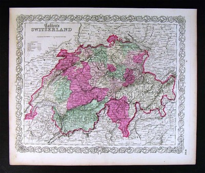
$4.00 Shipping Location: Rockville, United States Up for sale is a nice hand colored map published by C. B. Colton& Co. A colored map this is a one page map measuring approximately 17 by 15inches. ... morePublished 1854. Overall map is in fair condition. Some light browning around the edges. Several tears along the top and left edges. There are also a couple small rips along the bottom edges. One tear along the top border measures about 2 inches and extends slightly into the print of the map. The bottom left corner is torn off. Some slightly darker staining along the top left edge. Most rips and tears on this map do not extend beyond the boarder area into the map. Other chipping at edges. Small dings and nicks here and there mostly impacting boarder area. The back of this map contains writing about The Swiss Confederation. Map will look great framed. Please email with questions and see my store for other great items. E-20.
Buy It Now
$7.00 Shipping Location: Auburn, United States I believe the paper is vellum and it is hand colored because I can see a few places where the coloring went a slight bit out of the line.
$25.00 Shipping Location: Perugia, Italy Colton's firm arose from humble beginnings when he moved to New York in 1831 and befriended the established engraver Samuel Stiles. He worked under Stiles ... moreas the 'Co.' in Stiles and Co. from 1833 to 1836.
Buy It Now
$4.00 Shipping Location: Rockville, United States Up for sale is a nice hand colored map published by C. B. Colton & Co. Published 1856. Overall map is in fair condition. Several small tears along all ... moreedges. Folding and ripping along corners and edges.
Buy It Now
$10.00 Shipping Location: Montrose, United States Colton established his firm in New York in 1831. Joseph Hutchins Colton (July 5, 1800 – July 29, 1893), known professionally asJ.H. Publisher: J.H. Colton ... more& Co. They were often individually had water colored and were recognized for their distinctive borders.
$21.97 Shipping Location: Chicago, United States This map is from the J. H. Colton (New York, New York) map atlas printed in 1856. J. H. Colton Co. of New York were the premier map printer in the USA. ... moreEvery other county is colored with a light tint of blue.

Buy It Now
$5.50 Shipping Location: Easton, United States Auction Wizard 2000 Listing Template- AW2KLOT#2644 Please note that Customs delays for international shipping have been SIGNIFICANT lately- days or even ... moreweeks longer than they should be! Please take this into consideration Our goal is 5 star service! If you feel we have not lived up to a 5 star rating. Please contact us as we only want 100% satisfied customers and NO misunderstandings! Description below pictures* 1855 MAP OF PENNSYLVANIA Original Colton Hand Colored RARE* $85.80 PENNSYLVANIA This is an original antique map published by J.H. Colton& Co. 1855. Excellent detail and many Place Names. Beautiful Hand coloring! Edge tears and wear at edges. Text on verso of map* SCARCE* Overall size: 17 1/8" x 14 1/4" Please view our other eBay listings to see many more wonderful items! We gladly combine shipping! Each item is packaged very carefully and securely to ensure a safe arrival A Better Online Bookstore We are proud to be a green company. We strive to be earth friendly in all aspects of our business. It is our responsibility to care for our environment. We will reuse and recycle our shipping supplies while making sure that your item is packed in a clean and sturdy enclosure. Our goals are to make sure your item arrives safely and in as timely a manner as possible. Place your bid confidently with us. Reduce. Reuse, Recycle U.S. Buyers: Shipping costs are noted at the top of auction page. International Buyers: Please use the shipping calculator at the end of this auction. Please note that the U.S. Postal Service no longer offers Surface shipping so your costs will be higher. Thank You very much for your purchase! abetteronlinebookstorellc 2644
Buy It Now
Free Shipping Location: Monroeville, United States THIS ITEM IS A GENUINE ORIGINAL VINTAGE PRINT FROM THE SOURCE/DATE LISTED Name- New York. Pennsylvania, New Jersey, Delaware, backed with Vermont, Massachusetts, ... moreRhode Island, and Connecticut Date- 1864 Atlas. Maps are dated 1860 Source- J. H. Colton’s School Atlas and American School Geography By- J. H. Colton and G. Woolworth Colton Publisher- Ivison. Phinney and Company, New York Size- 11.5x13.5“ Hand-colored Condition- Quite Nice Yes! We Do Combine Shipping on Multiple Purchases! Payment due within 14 days after our initial after auction contact. Pennsylvania residents MUST add applicable SALES TAX or send resale number. Thanks. Good Luck! To See Our Other Auctions and Store Items CLICK HERE!
Buy It Now
$25.00 Shipping Location: Denver, United States Published in New York in 1855.
Buy It Now
$8.70 Shipping Location: Piqua, United States This is for a nice, hand painted antique map. - does not effect the graphical area of the atlas. SWITZERLAND +. This map is in good condition, and does ... moreshow typical page discoloration from age. I tried to capture them in the photo if so.
Buy It Now
$6.95 Shipping Location: Dover, United States J. H. Colton, Map Publishers. Issued c.1850'- early 1860s, likely promotional re-issues of earlier engraved prints, found here overprinted on reverse ... morewith period local (New york city) advertising in this era.
Buy It Now
$7.00 Shipping Location: Rockville, United States Up for sale is a great, original, colored, ANTIQUE MAP from J.H. Colton & Co., New York. It is blank on the reverse side.
Buy It Now
$7.00 Shipping Location: Rockville, United States Genuine antique map"Colton's Missouri" Entered according to act of Congress in the year 1855 by J.H. Colton. from Colton's General Atlas ... morepublished by G.W. C.B. Colton& Co. 172 William St, New York. The image shows nice detail of counties, railroads, roads and cities. Inset depicts the city of St Louis. Bright o riginal hand coloring and surrounded by Colton's signature intertwining border. Map has some pencil marks on image. Paper is in good condition. Measures 13" x 15 1/2" NOT A REPRODUCTION. All of our items are genuine antiques as described.
Buy It Now
$10.00 Shipping Location: Montrose, United States Colton established his firm in New York in 1931. Colton completed the contract, but was not paid by the Bolivians, where they were in the throws of a ... morerevolution. They are also found in university and museum collections.
Buy It Now
$8.70 Shipping Location: Piqua, United States This is for a nice, hand painted antique map. - does not effect the graphical area of the atlas. AFRICA North Eastern Sheet +. This map is in good condition, ... moreand does show typical page discoloration from age.
Buy It Now
$10.00 Shipping Location: Montrose, United States Colton established his firm in New York in 1831. Joseph Hutchins Colton (July 5, 1800 – July 29, 1893), known professionally asJ.H. Publisher: J.H. Colton ... more& Co. They were often individually had water colored and were recognized for their distinctive borders.
Buy It Now
$24.70 Shipping Location: Piqua, United States This is for a nice, hand painted antique map. - does not effect the graphical area of the atlas. This map is in good condition, and does show typical ... morepage discoloration from age. I tried to capture them in the photo if so.
Buy It Now
$6.95 Shipping Location: Dover, United States Colton's England and Wales. Issued 1855-65, New York by J.H. Colton. Uncommon large format mid 19th century lithographed map, with original hand color. ... moreOriginal center fold as issued.
Buy It Now
$6.95 Shipping Location: Dover, United States Issued c. 1855-65, New York by J.H. Colton. England & Wales. Mid 19th century engraved map with original hand color.
Buy It Now
$36.55 Shipping Location: Tappan, United States
Buy It Now
$10.00 Shipping Location: Montrose, United States Colton established his firm in New York in 1831. Colton completed the contract, but was not paid by the Bolivians, where they were in the throws of a ... morerevolution. Joseph Hutchins Colton (July 5, 1800 – July 29, 1893), known professionally asJ.H.
Buy It Now
$6.00 Shipping Location: Piqua, United States This is for a nice, hand painted antique map. - does not effect the graphical area of the atlas. Map is in good condition, and does show typical page ... morediscoloration from age. I tried to capture them in the photo if so.
Buy It Now
$8.70 Shipping Location: Piqua, United States GREECE and the IONIAN REPUBLIC +. This is for a nice, hand painted antique map. - does not effect the graphical area of the atlas. This map is in good ... morecondition, and does show typical page discoloration from age.
Buy It Now
$12.45 Shipping Location: Cambridge, United States JH Colton & Co. New York. - 1855 Map of Austria Sheet. No. 172 Williams St., New York. Hand-colored. Approximate size 17” x 13 3/4”. Has a couple small ... morefoxing age spots but very nice map. Shipped with USPS Priority Mail probably rolled.
Buy It Now
$12.45 Shipping Location: Cambridge, United States JH Colton & Co. No. 172 William St., New York. - 1855 Map of Africa. North Eastern Sheet. Hand-colored. Approximate size 17” x 13 3/4”. Has a couple of ... moresmall age spots otherwise fine. Shipped with USPS Priority Mail probably rolled.
Buy It Now
$3.95 Shipping Location: Clarkston, United States Geological Survey (U.S.). [New York, John Bachmann, c1861]. [Washington, D.C.], 1935-. cw0304500 Bachmann, John. [S.l.], U.S. Coast Survey, A. D. Bache, ... moreSupt., [1865]. cw0079a60 Nicholson, W. L. Silers Bald.
Buy It Now
$20.60 Shipping Location: Dover, United States Issued 1891, NY by G.W. & C.B. Colton & Co. Fine large late 19th century antique pocket map, lithographed with original hand color. Printed on bond paper. ... moreLarge decorative scroll and vegetation border.

Buy It Now
$65.90 Shipping Location: Holliston, United States 2 ORIGINAL 1859"CORNELL'S OUTLINE MAPS NO 9& 11. DRAWN BY G WOOLWORTH COLTON TO ACCOMPANY CORNELL'S SERIES OF SCHOOL GEOGRAPHIES. D APPLETON& ... moreCO NEW YORK. EUROPE WALL MAPS THIS IS A REALLY GREAT PAIR. THESE CAME WITH THE ORIGINAL ARNOLD GUYOT WALL-ATLAS MAPS I AM ALSO SELLING. I HAVENT BEEN ABLE TO FIND ANY OF THESE PRE CIVIL WAR SCHOOL WALL MAPS. MADE IN AMERICA. THESE WERE DONE IN 1859 TO HANG IN SCHOOLS TO TEACH THE STUDENTS ABOUT EUROPE. BOTH MEASURE 26 X 31 INCHES. NO 11 IS THE COLOR ONE AND IS IN GOOD CONDITION. MAP IS COMPLETE WITH GREAT ORIGINAL COLOR. THERE IS A BUNCH OF SPOTTING ALL ALONG THE BOTTOM 1/3 OF THE MAP. ATTACHED TO ITS ORIGINAL CARD BACKING WITH FABRIC SELVAGE. EDGE SHOWS BUMPS AND TEARS BUT NOTHING TOO BAD. SOME MINOR WARPING AS WELL. NO 9 EXHIBITS VERY LITTLE COLOR. SAME SIZE AND BASIC CONDITION. THERE IS PAPER LOSS ALONG THE BOTTOM MARGIN AND A COUPLE OF THE CORNERS. BOTH MAPS WOULD DISPLAY EXCELLENT IF THEY WERE MATTED AND FRAMED. MAPS WITHIN THE NEATLINE ARE REALLY EXCELLENT EXAMPLES OF EARLY AMERICAN SCHOOL MAPS. CHECK THE PICTURES ON THIS GREAT PIECE. DONT MISS THIS OPPORTUNITY. SHIPPING AND HANDLING AND INSURANCE CAN BE CALCULATED. ALL ITEMS ARE BEING SOLD AS IS. PICTURES ARE AN EXCELLENT INDICATION OF CONDITION. CHECK MY FEEDBACK AND YOU WILL SEE THAT MY CUSTOMERS ARE HAPPY. I GENERALLY SHIP ONCE A WEEK SO PLEASE BE PATIENT. IT TAKES TIME TO MAKE SURE ALL OF THIS ART AND ANTIQUES ARRIVE SAFELY. PLEASE DONT HESITATE TO EMAIL ANY QUESTIONS. THANKS FOR LOOKING AND HAPPY BIDDING.
Buy It Now
$6.95 Shipping Location: Dover, United States Issued 1855, New York by J.H. Colton & Co. Sweden and Norway. Uncommon mid 19th century lithographed map, with original hand color.

Buy It Now
$4.99 Shipping Location: Fairview, United States Lake Erie Maps& Prints! An Authentic Antique Map: Not a Modern Reproduction! See Our Ebay Store for other! Free Shipping on Purchases of 5 or More ... moreMaps and Prints Description: It is an original engraved antique map over 145 years old with original hand coloring as issued. It is from Colton's General Atlas. Published in New York by the Colton& Co. 1866. There is a copyright date of 1855 in the bottom right. A facsimile copy of the title page will also be included for authenticity. The map is not mounted, matted nor framed, being sold as a single elephant size folio sheet as shown in the main pic. Size: The map image measures approximately 12 1/2 by 15 1/2 inches(32x39cm) on a 15 1/2 by 18 1/2" 37x44cm) page with a margin all around for framing as seen in the pic. Condition: The map is in Fair to Good condition with overall light tonal aging and original hand coloring as issued. There are some damp stains around the margins as seen. Otherwise the image area is clean with strong color that would frame up well, see the pics for more on condition. The pics are of the actual map. Payment Details: We accept most major credit cards through Paypal and Ebay. Please ask if you have any questions about payment. International and New Bidders are welcomed and encouraged. Payment is expected within 7 days. After which Nonpaying Bidders will be reported to Ebay to recoup our listing fees. Save on Shipping: We only charge one shipping fee based on the largest map or print with multiple items shipped along with it for no extra costs. Purchase 5 or more maps or prints and receive Free First Class shipping in USA or First Class International elsewhere in the world. Although registration may be required on shipments of high value. International Customs and VAT Fees: It is the responsibility of the buyer to pay all Customs Taxes. VAT or other fees that may be due upon arrival. These fees vary greatly from country to country and ebay policy is that the buyer is responsible for their country's taxes and fees. Please
Buy It Now
$10.00 Shipping Location: Montrose, United States Colton established his firm in New York in 1831. Joseph Hutchins Colton (July 5, 1800 – July 29, 1893), known professionally asJ.H. Publisher: J.H. Colton ... more& Co. They were often individually had water colored and were recognized for their distinctive borders.
Buy It Now
$19.45 Shipping Location: Fort Wayne, United States This map is printed on high-quality paper from steel plates - the color was added by hand to each individual map. This is an estate fresh find, new to ... moremarket! This is one of the earliest and rarest editions of the Colton Atlas.
Buy It Now
$10.00 Shipping Location: Montrose, United States Publisher: J.H. Colton & Co. Date: 1856 First Edition (on the map it says "Entered as an Act of Congress in the year 1855" but the atlas was published ... morein 1856). Original Antique Map-Turkey in Asia. Size: 13" x 15 1/2" (including margins 16" x 18 ") 33 x 39 cm (including margins 41 x 47cm).
Buy It Now
$10.00 Shipping Location: Montrose, United States Colton established his firm in New York in 1831. Colton completed the contract, but was not paid by the Bolivians, where they were in the throws of a ... morerevolution. They are also found in university and museum collections.
Buy It Now
$10.00 Shipping Location: Montrose, United States Colton established his firm in New York in 1831. Colton completed the contract, but was not paid by the Bolivians, where they were in the throws of a ... morerevolution. Publisher: J.H. Colton & Co. They were often individually had water colored and were recognized for their distinctive borders.
Buy It Now
$7.00 Shipping Location: Rockville, United States The map in generally Very Good condition (not perfect but very nice). Dark stains around the border, however, they don't affect the map, except for the ... morevery right portion above the Delaware River. The map is blank on the reverse side.
Buy It Now
$3.95 Shipping Location: Clarkston, United States Martenet’s Map of Harford County, Maryland : shore lines and tide water from U.S. Coast Survey, the county from actual surveys / under direction of Simon ... moreJ. Martenet, Baltimore. Schmidt & Trowe, lithographers.
Buy It Now
$10.00 Shipping Location: Montrose, United States Colton established his firm in New York in 1931. Colton completed the contract, but was not paid by the Bolivians, where they were in the throws of a ... morerevolution. They are also found in university and museum collections.
Buy It Now
$10.00 Shipping Location: Montrose, United States Colton established his firm in New York in 1931. Colton completed the contract, but was not paid by the Bolivians, where they were in the throws of a ... morerevolution. Joseph Hutchins Colton (July 5, 1800 – July 29, 1893), known professionally asJ.H.
Buy It Now
$10.00 Shipping Location: Montrose, United States Colton established his firm in New York in 1831. Joseph Hutchins Colton (July 5, 1800 – July 29, 1893), known professionally asJ.H. Publisher: J.H. Colton ... more& Co. They were often individually had water colored and were recognized for their distinctive borders.
Buy It Now
$4.99 Shipping Location: Fairview, United States Lake Erie Maps& Prints! An Authentic Antique Map: Not a Modern Reproduction! See Our Ebay Store for other! Free Shipping on Purchases of 5 or More ... moreMaps and Prints Description: It is an original engraved antique map approximately 150 years old with original hand coloring as issued. It is from Colton's General Atlas. Published in New York by the Colton& Co. 1865, with a copyright date of 1855 in small print on the map. A facsimile copy of the title page will also be included for authenticity. The map is not mounted, matted nor framed, being sold as a single elephant size folio sheet as shown in the main pic. Size: The map image measures approximately 12 1/2 by 15 1/2 inches(32x39cm) on a 131/2 by 17" 34x40cm) page with a margin all around for framing as seen in the pic. Condition: The map is in Very Good condition with overall light tonal aging and original hand coloring as issued. There is a very light hint of a damp stain along the left margina and a couple of small spots. Otherwise it is very clean with with nice strong color that would frame up well, see the pics for more on condition. The pics are of the actual map. Payment Details: We accept most major credit cards through Paypal and Ebay. Please ask if you have any questions about payment. International and New Bidders are welcomed and encouraged. Payment is expected within 7 days. After which Nonpaying Bidders will be reported to Ebay to recoup our listing fees. Save on Shipping: We only charge one shipping fee based on the largest map or print with multiple items shipped along with it for no extra costs. Purchase 5 or more maps or prints and receive Free First Class shipping in USA or First Class International elsewhere in the world. Although registration may be required on shipments of high value. International Customs and VAT Fees: It is the responsibility of the buyer to pay all Customs Taxes. VAT or other fees that may be due upon arrival. These fees vary greatly from country to country and ebay policy is that the buyer is responsible
Buy It Now
$6.00 Shipping Location: Denver, United States G. W. & C. B. Colton & Co., New York: G. W. & C. B. Colton & Co., 1883. Colton's Map of England and Wales (pocket map version). Large hand-colored map ... morefolding into original blindstamped brown pocket covers with gilt front cover title "Colton's Map of England".
Buy It Now
$10.00 Shipping Location: Montrose, United States Colton established his firm in New York in 1831. Joseph Hutchins Colton (July 5, 1800 – July 29, 1893), known professionally asJ.H. Publisher: J.H. Colton ... more& Co. They were often individually had water colored and were recognized for their distinctive borders.

Buy It Now
$4.99 Shipping Location: Fairview, United States Lake Erie Maps& Prints! An Authentic Antique Map: Not a Modern Reproduction! See Our Ebay Store for other! Free Shipping on Purchases of 5 or More ... moreMaps and Prints Description: It is an original Civil War era engraved antique map over 138 years old with original hand coloring as issued. It is from Colton's General Atlas. Published in New York by the Colton& Co. 1865. A facsimile copy of the title page will also be included for authenticity. The map is not mounted, matted nor framed, being sold as a single elephant size folio sheet as shown in the main pic. Overall, a beautiful rare map with nice color that would frame up nicely. Size: The map image measures approximately 12 1/2 by 15 1/2 inches(32x39cm) on a 15 1/2 by 18 1/2" 37x44cm) page with a margin all around for framing as seen in the pic. Condition: The map is in Very Good condition with overall light tonal aging and original hand coloring as issued. There is a minor nick off the corner. Otherwise it is very clean with strong color that would frame up well, see the pics for more on condition. The pics are of the actual map. Payment Details: We accept most major credit cards through Paypal and Ebay. Please ask if you have any questions about payment. International and New Bidders are welcomed and encouraged. Payment is expected within 7 days. After which Nonpaying Bidders will be reported to Ebay to recoup our listing fees. Save on Shipping: We only charge one shipping fee based on the largest map or print with multiple items shipped along with it for no extra costs. Purchase 5 or more maps or prints and receive Free First Class shipping in USA or First Class International elsewhere in the world. Although registration may be required on shipments of high value. International Customs and VAT Fees: It is the responsibility of the buyer to pay all Customs Taxes. VAT or other fees that may be due upon arrival. These fees vary greatly from country to country and ebay policy is that the buyer is responsible for their country's taxes and fees.
Buy It Now
$4.00 Shipping Location: United States This dates the map nicely. The gorgeous delicate handcoloring is period to the map this is before color printing. The map is printed on thick paper with ... moreno printing on reverse. Fine outside ornate border as well.
Buy It Now
$12.45 Shipping Location: Cambridge, United States JH Colton & Co. New York. - No. 172 Williams St., New York 1855 Map of Switzerland Sheet. Hand-colored. Approximate size 17” x 13 3/4”. Has a couple small ... morefoxing age spots but very nice map. Shipped with USPS Priority Mail probably rolled.
Buy It Now
$25.00 Shipping Location: Belvedere Tiburon, United States These created much more well-defined print lines, allowing even minute features and labels to stand out clearly. By 1882, most states or territories had ... morebeen defined, so we find them present and labeled.
Buy It Now
$6.00 Shipping Location: Columbus, United States New York, NY. This map is in Very Good condition, with bright coloring. The map shows toning to the edges and light scattered foxing/soiling, and is held ... morein a clear, plastic, protective slip.
Buy It Now
$12.70 Shipping Location: Piqua, United States This is for a nice, hand painted antique map. - does not effect the graphical area of the atlas. This map is in good condition, and does show typical ... morepage discoloration from age. I tried to capture them in the photo if so.
Buy It Now
$10.00 Shipping Location: Montrose, United States Colton established his firm in New York in 1831. Joseph Hutchins Colton (July 5, 1800 – July 29, 1893), known professionally asJ.H. Publisher: J.H. Colton ... more& Co. They were often individually had water colored and were recognized for their distinctive borders.
Buy It Now
$9.30 Shipping Location: Plano, United States New York: C. W. & C. B. Colton & Co., 1878. Early reprint edition. Publisher’s brown pebbled cloth, stamped in gilt to front cover, embossed to front ... moreand rear boards. [Together with:]Oliver F. Weagon.
Buy It Now
$10.00 Shipping Location: Montrose, United States Publisher: J.H. Colton & Co. Date: 1856 First Edition (on the map it says "Entered as an Act of Congress in the year 1855" but the atlas was published ... morein 1856). Original Antique Map. Size: 13" x 15 1/2" (including margins 16" x 18 ") 33 x 39 cm (including margins 41 x 47cm).
Buy It Now
$10.00 Shipping Location: Montrose, United States Publisher: J.H. Colton & Co. Date: 1856 First Edition (on the map it says "Entered as an Act of Congress in the year 1855" but the atlas was published ... morein 1856). Size: 13" x 15 1/2" (including margins 16" x 18 ") 33 x 39 cm (including margins 41 x 47cm).
Buy It Now
$10.00 Shipping Location: Montrose, United States Publisher:J.H. Colton & Co. Original Antique Map of the Western Hemisphere. Date: 1856 first edition (on the map it says "Entered as an Act of Congress ... morein the year 1855" but the atlas was published in 1856) Heavy paper-Hand Colored.
Buy It Now
$4.99 Shipping Location: Fairview, United States Colton's General Atlas, published in New York by the Colton & Co., 1874. A facsimile copy of the title page will also be included for authenticity. Condition: ... moreThe map is in Very Good condition with overall light tonal aging and original hand coloring as issued.
Buy It Now
$3.95 Shipping Location: Clarkston, United States This DVD is part of our Historic Map and Atlas Collection. The results are very high quality and convincing. 0149013 Colton, G.W. New Brunswick, Nova ... moreScotia, … 1856 0149014 Colton, G.W. Canada East Or Lower Canada … 1856.
Buy It Now
$6.95 Shipping Location: Dover, United States Issued 1865, New York by J.H. Colton. Eastern Hemisphere. Most of central Africa is blank although the apocryphal Mts. of the Moon range is labelled and ... morelocated. Mid 19th century engraved map with attractive hand color.
|
|
|
In
|
Hand Colored Map of Minnesota & Wisc (1855) G.W. and C.B. Colton & Co., New York
Up for sale is a nice hand colored map of Minnesota on one side. And Wisconsin on the other side published by C. B. Colton& Co. A colored map this is a two page map measuring approximately 35 by 15 inches. Published 1855. Overall map is in fairly good condition. Some light browning around the edges. Several very small rips and tears along borders. Tears on top border are slightly larger. But do not affect the print of the map. There is also a crease down the middle where map is originally folded, and was originally two pieces. The map of Wisconsin on the back also contains several rips along edges, but none affecting the print of the map. Rips and tears on this map do not extend beyond the boarder area into the map. Other chipping at edges, small dings and nicks here and there mostly impacting boarder area. The back of this map contains ... moreon one side. Writing about The State of Minnesota, and on the other side, a map of Wisconsin. Map will look great framed. Please email with questions and see my store for other great items. E-26.
|
|
|
Hand Colored Map of Missouri (1855) G.W. and C.B. Colton & Co., New York
Up for sale is a nice hand colored map published by C. B. Colton& Co. A colored map this is a one page map measuring approximately 17 by 15 inches. Published 1855. Overall map is in acceptable condition. Some light browning around the edges. Quite a few tears around the borders. Most are small. A few long enough that extend into the map. One along the right border that is about 1.5 inches long. One along the bottom about 1.5 inches long. Corners are folded and slightly torn. Most rips and tears on this map do not extend beyond the boarder area into the map. Other chipping at edges, small dings and nicks here and there mostly impacting boarder area. The back of this map contains writing about The State of Wisconsin. Map will look great framed. Please email with questions and see my store for other great items. E-8.
|
|
 |