|
|
Order by: Available to: This site contains affiliate links for which I may be compensated
|
Buy It Now
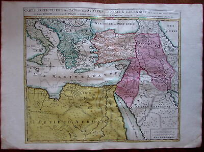
$11.85 Shipping Location: Dover, United States Carte Particuliere des Pais ou Les Apotres ont Preche l'Euan Gile; des Lieux les Plus Renommez de Leurs Voyages. Et de la Route de St. Paul a Rome. ... moreDressee pour bien entendre l'Histoire Sainte. Mediterranean. Arabia, Turkey, Greece, Armenia, North Africa) Issued Amsterdam. C. 1730-40 by Covens& Mortier. Fine mid-18th century engraved folio sheet map of the Mediterranean and Middle East. With original hand color. Quite interesting for the detailed depiction of Arabia. Armenia and Turkey during the time of the Apostles travels. In VG to near fine. Clean, well-preserved condition. A fine map. Sheet measures c. 24" W x 17" H. Printed area c. 18 1/4" W x 15" H. Folio. Tooleys Dictionary of Mapmakers. Vol. 1, p. 308. Marco van Egmond. Covens& Mortier. 3.3 R564. Everything we offer is guaranteed to be an authentic original antique item as described. We stand behind everything we sell. Important information for International Buyers* You may be charged customs. Taxes or other import duties by your country! this has nothing at all to do with us. Please do not hold us responsible if your Government wants to collect tax when you buy something outside of your country] Import duties. Taxes, and customs fees are not included in the item price or shipping cost. These charges are normally collected by the shipping service when the package is delivered or when you pick the item up. They are the buyer's responsibility and are not additional shipping charges. Please understand they have nothing to do with us and we have no control over them] Please check with your country's customs office to determine what these additional costs will be prior to bidding or buying. We do not know the various rules of your Customs office. There are a lot of countries in the world. Most with complex detailed variable laws in languages we don't read. Plus these laws are constantly being changed& revised] We won't under-value merchandise or mark the item as a gift on customs forms. Doing so is again
Buy It Now
$11.85 Shipping Location: Dover, United States Issued Amsterdam, c.1711 by Covens & Mortier. Covens & Mortier, 3.3. Scarce early 18th century folio sheet Dutch issued map of the Holy Land. Engraved ... morewith original hand color.
Buy It Now
$29.75 Shipping Location: Louisville, United States Considerable detail is seen in the interior, cities, towns, mountain ranges and the two famous bodies of water, the Sea of Galilee and the Dead Sea. Map ... moreof the Holy Land. Old reproduction but I'm not sure from when.
Buy It Now
$11.85 Shipping Location: Dover, United States Issued 1753, London. Engraved by G. Child. (Atlantic Islands, Portuguese Colonies, Madeira, Dragon Tree, Dragon's Blood, Resin). Fine mid 18th century ... moreengraved map of this island with a giant engraved view of the "Dragon Tree" which has a pot hanging from its branch to collect the "dragon blood" in.
$20.00 Shipping Location: Cleveland, United States Thi s atlas is difficult to acquire in their own right; much less one that is as complete, intact and overall clean as is this. We have recently been ... morefortunate enough to acquire, for example, the original watercolors from Lewin's "Birds of Great Britain".
Buy It Now
$3.50 Shipping Location: Winter Springs, United States Nicely detailed and attractive period map of these states. The fine handcoloring is period to the map, this is before color printing. The size of the ... moremap is 10" by 12". FREE scheduling, supersized images.
Buy It Now
Free Shipping Location: Sayville, United States On the rear is an area and population table for each county with data from the 1890 census. See photo's.
Buy It Now
$3.65 Shipping Location: United States Fine antique 1902 color lithographed map, titled Nebraska. Nicely detailed, and beautiful period color lithography. The size of the map is 11" by 14.5". ... moreFREE scheduling, supersized images.
Buy It Now
$3.50 Shipping Location: Winter Springs, United States Fine antique 1783 copperplate map, titled Germany. Printed at bottom is Published as the Act directs. The size of the map is 10.5" by 12". FREE scheduling, ... moresupersized images.
Buy It Now
Free Shipping Location: Sayville, United States
Buy It Now
$2.65 Shipping Location: Winter Springs, United States Very nicely engraved, attractive and detailed period map. The map is printed on fine period handmade paper, no printing on reverse. The size of the map ... moreis 3.75" by 6". FREE scheduling, supersized images.
Buy It Now
$6.00 Shipping Location: Newnan, United States 1830-1840s NORTH AMERICAN MAP. 11 1/4" by 7 3/4". Fine condition.
Buy It Now
$3.75 Shipping Location: United States Superb, fine antique 1889 color lithographed map, titled Map of Cincinnati. Nicely detailed, beautiful color and fascianting period details and information, ... moreprinted on thick paper, very nice period color lithography.
Buy It Now
Free Shipping Location: The Rocks, Australia Through its detailed depiction of the eight provinces, this 19th-century map provides a valuable historical resource, shedding light on the administrative ... moredivisions and regional dynamics of Korea during the late Joseon dynasty.
Buy It Now
$9.95 Shipping Location: Dover, United States Issued 1752, Paris by Bellin. Original fold lines as issued. Mid 18th century engraved map with attractive hand color.
Buy It Now
Free Shipping Location: Washington, United States Infrequent light spotting/foxing in margins but generally clean and bright. Incredible 4-sheet original copper-plate engraved antique map of Africa, by ... moreDavid Lizards (Edinburgh) 1831 (undated but references indicate this is from "The Edinburgh Historical and Geographical Atlas", published by Whittaker, Treacher & Co. (London), John Hamilton (Edinburgh) and W. Curry, Jun. & Co. (Dublin). ).
Buy It Now
$3.50 Shipping Location: Winter Springs, United States The detail is amazing. The size of the map is 14" by 22". FREE scheduling, supersized images.
Buy It Now
$4.00 Shipping Location: Winter Springs, United States Very fine, large antique 1886 handcolored 2 sided map, one side is titled Germany No 3, reverse is Germany No 4. This is a Colton map, Colton was a highly ... moreregarded mapmaker of this period. The gorgeous handcoloring is period to the map, this is before color printing.
Buy It Now
$3.00 Shipping Location: United States Fine antique 1854 handcolored map, titled Spain, Portugal. Attractive and interesting period map of these areas. Printed on fine thick paper, no printing ... moreon reverse. The size of the map is 5.25" by 7".
Buy It Now
$3.65 Shipping Location: United States Fine antique 1892 color lithographed map, titled North & South Dakota. Nicely detailed and attractive period map. Much has changed since 1892. Fine perod ... morecolor lithography, printed on thick paper.
Buy It Now
$3.50 Shipping Location: Winter Springs, United States Leroy, with inset map France, comparee. Belin is a highly regarded mapmaker of this period. Very finely produced, printed on superb paper, with no printing ... moreon reverse. The gorgeous handcoloring is period to the map, this is before color printing.
$25.00 Shipping Location: Perugia, Italy Date: 1720 ( undated ). The map includes French explanatory tables along the lower side. Wide margins. Sheet folded. Tear ath the lower side repaired ... moreon the verso. Map folded. Conditions are as you can see in the images.
$25.00 Shipping Location: Perugia, Italy Bird's-eye of the city of Hesdin, France from the south. He is known for portraits and topographical views as well as historical allegories. He also produced ... morescenes of contemporary historical events.
Buy It Now
$3.75 Shipping Location: United States Very interesting period 1744 map of Germany, I see many fascianting areas and details, too much to list, but the detail is amazing. Much has changed, ... moreI see Bordeaux, Langouedoc Province, Spanish Provinces at upper right and much more.
Buy It Now
$3.75 Shipping Location: United States Superb, rare, fine antique circa 1880 color lithographed map, titled Map of Kansas City, Missouri and Kansas City, Missouri. Beautifully detailed and ... moreattractive period map. The size of the map is 13" by 17.5".
$46.95 Shipping Location: Farmingdale, United States NEW YORK: Cady & Burgess 1848 [published date: 1848]. Rare Eighth Edition. Fine original contemporary publisher's 1/4 fine leather binding over printed ... moreboards. A CONCISE AND PRACTICAL SYSTEM OF GEOGRAPHY.
Buy It Now
$2.65 Shipping Location: Winter Springs, United States Fine antique 1800 copperplate engraved map, titled Germany divided into Circles. Very nicely engraved, attractive and detailed period map of this area. ... moreThe map is printed on fine period handmade paper, no printing on reverse.
Buy It Now
$3.50 Shipping Location: Winter Springs, United States Belin is a highly regarded mapmaker of this period. Very finely produced, printed on superb paper, with no printing on reverse. The gorgeous handcoloring ... moreis period to the map, this is before color printing.
Buy It Now
$6.95 Shipping Location: Dover, United States Issued c. 1780-90, Paris by Bonne. Nice example of this iconic late 18th century engraved map, with very attractive hand color. Korea shown with interior ... moremountain ranges, Japan in erroneous outline form, Philippines at bottom.
Buy It Now
$11.85 Shipping Location: Dover, United States Issued 1872, New York by Asher & Adams. California & Nevada. Clean condition, light old damp staining in blank margin, small scattered age spots. Uncommon ... moreoversized 19th century lithographed map with original hand color.
Buy It Now
$111.53 Shipping Location: Tallahassee, United States JOACHIM OTTENS 1663-1719 - REINER OTTENS (son) 1698-1750 - JOSHUA OTTENS (son) 1704-65. Large Map Print " Mappe Monde " "Map of the World" a very fine ... moreprint of R & J Ottens Original work.
Buy It Now
$6.95 Shipping Location: Dover, United States Issued 1772, London. Engraved by T. Jefferys. Late 18th century engraved map with attractive hand color.
Buy It Now
$3.00 Shipping Location: United States Fine antique 1854 handcolored map, titled Western Hemisphere. The fine handcoloring is period to the map, this is before color printing. Attractive and ... moreinteresting period Western Hemisphere map. Printed on fine thick paper, no printing on reverse.
Buy It Now
$3.25 Shipping Location: Winter Springs, United States Superb, very fine early antique 1858 handcolored map, the map is printed on fine thick paper, with no printing on reverse. This is a Morse and Gaston ... moremap. Morse was a highly regarded mapmaker of this period.
Buy It Now
$10.00 Shipping Location: Cyprus 1# French Bourbourg antique map Bourbour, Beaulieu 1688. Fort De Link antique map Belgium France region by de Beaulieu 1688. Fortress Link near Cappelle-Brouck ... moreFrance, antique plan of the fortification area.
Buy It Now
$3.50 Shipping Location: Winter Springs, United States Very fine, superb, rare, antique 1765 copperplate engraved map, titled, in fancy antique lettering, An Accurate Map of the Southern Part of Lower Saxony ... moreDrawn from the best Authorities. Very finely produced, printed on thick period handmade paper, with no printing on reverse.
Buy It Now
$3.25 Shipping Location: Winter Springs, United States The size is 10" by 16". FREE scheduling, supersized images.
Buy It Now
$4.00 Shipping Location: United States E ven the water areas are handcolored a delicate light blue. Fine period map of this part of the world. The map has 2 light crease towards left hand side, ... moresee my photo. The map is printed thick fine paper, with no printing on reverse and with gorgeous period handcoloring, nice outside ornate border, and fascianting period details.
Buy It Now
$11.85 Shipping Location: Dover, United States 1777 Bowen folio hand color map. Issued 1777, London for Middleton. Map by Thomas Bowen. Very nice 18th century engraved map with attractive hand color.
Buy It Now
Free Shipping Location: Holliston, United States C FOLTMARS FORLAG.PRINTED IN EM. BIRDS EYE VIEW LITHOGRAPH. Such a beautiful place. And their example is in not very good shape. Still a clear image but ... morethe spots are there. With a cleaning, this could really be a very fine example of this scarce view of Copenhagen.
Buy It Now
$3.75 Shipping Location: United States Superb, fine antique 1889 color lithographed map, titled South Africa, nicely detialed, much has changed. Nicely detailed, beautiful color and fascianting ... moreperiod details and information, printed on thick paper, very nice period color lithography.
$25.00 Shipping Location: Perugia, Italy 1742 copper engraved frontispice of the Doppelmayr's Atlas Coelestis published by the Homann Heirs. Johann Baptist Homann (March 20, 1664 - July 1, 1724) ... morewas the most prominent and prolific map publisher of the 18th century.
Buy It Now
$3.00 Shipping Location: United States Fine antique 1854 handcolored map, titled Germany. Austria is shown as part of Germany. Attractive and interesting period map of these areas. Printed ... moreon fine thick paper, no printing on reverse. The size of the map is 5.25" by 7".
Buy It Now
$3.75 Shipping Location: United States Superb, fine antique 1889 color lithographed 2 sided map, titled China, with inset map of Japan, reverse is Persia. Nicely detailed, beautiful color and ... morefascianting period details and information, printed on thick paper, very nice period color lithography.
Buy It Now
Free Shipping Location: Orlando, United States Originally from the National Illustre this print was made by "V. Levasseue" and colored by hand. In the lower left corner is a blue ink stamp which reads ... more"Societe de Beaux Arts Nantes" and a blind stamp low right margin "AC" which could indicate this was an exhibited print.
Buy It Now
$4.00 Shipping Location: United States The map is printed on fine thick paper, with fascianting period details, and superb period handcoloring, showing Worcester County. The map is very detailed. ... moreThe map is printed on very thick fine paper, with no printing on reverse.
Buy It Now
$4.00 Shipping Location: Winter Springs, United States Any dark shadows are on the photo only, the map is in very fine beautiful condition. At left and right hand side are detailed charts related to these ... moreareas. The map is very finely printed on thick paper, with no printing on reverse.
Buy It Now
$3.50 Shipping Location: Winter Springs, United States Fascinating and detailed period Texas map. Very finely printed, beautiful period color lithography, and printed on thick paper. The size of the map is ... more14" by 22", The map is in nice condition. FREE scheduling, supersized images.
Buy It Now
$3.00 Shipping Location: United States Printed on fine thick paper, no printing on reverse. The size of the map is 5.25" by 7". FREE scheduling, supersized images.
Buy It Now
$3.75 Shipping Location: United States Delamarche 1834. I like how the year produced is right in the title, it dates the map nicely. The map is in beautiful condition, printed on fine superb ... morethick paper, with no printing on reverse. Printed on superb paper, with no printing on verso.
Buy It Now
$3.25 Shipping Location: Winter Springs, United States Very fine, antique 1819 copperplate engraved map, titled Russia in Asia. Printed at bottom is Published May 1, 1819, by J. Mawman and the other Proprietors. ... moreThis dates the map very nicely. Very finely engraved, printed on superb paper, no printing on reverse.
Buy It Now
$3.75 Shipping Location: United States Superb, fine antique 1889 color lithographed 2 sided map, titled Japan, and reverse is Russia in Asia, Turkestan & Etc. Nicely detailed, beautiful color ... moreand fascianting period details and information, printed on thick paper, very nice period color lithography.
$25.00 Shipping Location: Perugia, Italy Le Rouge was born in Hanover Germany as Georg Ludwig, where he was educated and employed as a military engineer and surveyor. He assisted his father on ... morea large-scale plan of Darmstadt, which he completed following his father's death in 1726.
$72.30 Shipping Location: Farmingdale, United States He was both an engraver and publisher of considerable reputation who was made Hydrographer to King George III. He worked with many of his contemporaries ... moreon various projects. LONDON: Printed for R. & J. Dodsley.
Buy It Now
$3.65 Shipping Location: Shrewsbury, United States Fine antique 1902 color lithographed map, titled Kansas. Nicely detailed, and beautiful period color lithography. The size of the map is 11" by 14.5". ... moreFREE scheduling, supersized images.
Buy It Now
$4.00 Shipping Location: United States The condition of the map is excellent, just amazing, esp. given the age of the map. Fine outside ornate border. This is an antique map and not a reprint ... moreor reproduction, the map is printed on thick paper, with no printing on reverse.
Buy It Now
$3.25 Shipping Location: Winter Springs, United States Fine, rare. antique 1880 color lithographed map, titled in fancy antique lettering and titled Eastern Hemisphere. Beautiful period map of this part of ... morethe world in 1880. The size of the map is 10.5" by 12".
Buy It Now
$3.75 Shipping Location: Winter Springs, United States The map is titled Plan of the State of New York, titled in fancy antique lettering. Printed on thick paper, with no printing on reverse. This is an antique ... moremap and not a reprint or reproduction. The handcoloring on the map is period to the map, this is before color printing.
Buy It Now
$6.95 Shipping Location: Dover, United States Issued c. 1855-60, Edinburg by A, Fullarton & Co. Drawn & engraved by Swanston. Mid 19th century lithographed map with original hand color. Countries ... morein the Northern Tropical Regions of Africa.

Buy It Now
Free Shipping Location: Netherlands ABOUT US VISIT OUR STORE SALES SPECIALS Antique Manuscript Map-ITALY-SICILY-Van Bommel-1863 Description: Original manuscript map. Netherlands ca. 1865. ... moreArtists and Engravers: We acquired a series of maps by P. van Bommel. Some are dated 1863-1865. We have not been able to ind additional information on this cartographer. Draftsman or scholar. Subject: Map: Italie' Map of Italy. Hand drawn map by Dutch geography/ cartography student P. van Bommel. Condition: Fine. General age related toning. Irregular paper edges with small tears. Size(in cm) The overall size is ca. 26 x 33 cm. The image size is ca. 21.5 x 27 cm. Size(in inch) The overall size is ca. 10.2 x 13 inch. The image size is ca. 8.5 x 10.6 inch. Medium: Original drawing on a vellin type paper. Location: A195-14 ThePrintsCollector Peter Cornelissen. Margo van Latum- van Dongen, Frank van Latum Zeeland- The Netherlands Phone: +31 654 21 23 78 Worldwide free shipping on all orders. We ship within one business day upon receipt of payment. We ship by Registered Mail. Insurance is included. We guarantee our items to be genuine original. Visit our Store: we would like to invite you to review similar items in our Store or to browse through all other items in our Store. We are confident that you will find very special unique antique maps and prints in our Store. It is our privilege to have you as a customer. We accept Paypal payments and payment by bank transfer. Combined auction/ buy it now orders are possible! We will send a Paypal invoice on request! THE PRINTSCOLLECTOR GUARANTEES ITEMS SOLD THROUGH EBAY ARE GENUINE ORIGINAL ANTIQUE PRINTS IN THE CONDITION/TECHNIC AS DESCRIBED. ITEMS CAN BE RETURNED WITHIN 7 DAYS. Powered by
|
|
|
|
Ireland Hibernia c.1730 Covens & Mortier antique folio map w/ 2 fine cartouches
INEXPENSIVE LOW COST GLOBAL SHIPPING ON ALL MAP/ PRINT ORDERS OVER $100* Ireland Hibernia c.1730 Covens& Mortier antique folio map w/ 2 fine cartouches Hyberniae Regni in Provincias Ultoniam. Connacham, Lagentiam. Momoniamq. Ireland) Issued c. 1720-30. Amsterdam by Covens& Mortier. Wondeful folio antique engraved map printed in the early 18th century. With beautiful full hand color. Two large ornate vignette cartouches, sailing ships, poseidon, allegorical historical figures, etc. In VG to VG+ condition. Light minor age wear, overall remaining clean and very attractive. Pleasing example of this original antique map. This example which appeared folded within a History set as opposed to an atlas. Sheet measures c. 21 1/4" W x 25 1/4" H. Engraved area measures c. 23 1/4" H x 19 1/4" H. Folio. Original fold lines as ... moreissued. Ryhiner Collection. Bern Switzerland, on-line Ryh_2001_42.jpg Tooleys Dictionary of Mapmakers. Vol. 1, p. 308. Van Egmont. Covens& Mortier 1685-1866. R255. Please look carefully and make your decision knowing this antique image is nice. But it is likely not in perfect"like new" condition. However, with whatever flaws it possesses, it remains entirely worthy of ownership and inclusion in any related collection. We feel it will prove very pleasing to its new owner. If not, simply return it for a prompt courteous refund. Everything we offer is guaranteed to be an authentic original antique item as described. We do not handle or deal in modern reproductions and stand behind everything we sell. Please visit our. NEW 2013 SHIPPING& TERMS: We are now offering inexpensive/ affordable World-wide economy shipping on all map/ print overs over $100! $25 flat-rate insured shipping to anywhere in the world on all map orders over $100* This is substantially less than it will actually cost us. In order to receive this reasonable low cost Global map shipping. Please request an invoice from us prior to paying. All orders below $100 pay
|
|
|
Ireland Ulster Dublin c.1830 fine antique engraved map
a New Map of Ireland Issued c.1830. London Fine original antique engraved map. With lovely hand color. Printed on quality paper which retains its inherent structural flexibility and soundness. In near VG or better condition. Mostly clean and attractive, minor light surface age wear and some light uniform age toning as typical, the map is very presentable and well worthy of ownership& display[note: we grade very conservatively and always seek to disclose any noteworthy flaws] The printed area remains visually pleasing. A nice impression of an interesting antique map. Any minor defects along the sheet edges and in the margins may be seen in the photos. Sheet measures c. 10 1/4" W x 12 1/8" H. Engraved area measures c. 8 5/8" W x 10 3/4" H. Original fold lines as issued. 45776] Guaranteed Authentic! We do not sell modern ... morereprints. Condition All of our items are original antique pieces and it is important to keep in mind that many of them have been around for 100 years or more. Individual pieces may have seen many owners and been handled many times over the course of their existence and as a result each piece has developed a history of it's own. Short edge splits(often repaired with archival tape) Foxing, discoloration, etc. are all things to expect on items of this type. They rarely distract from the piece and often add to the overall character of the item. Keep in mind when you receive your item that you are not handling a modern copy, you are holding a piece of history, an item that has been around for a very long time and will, with proper care, be around for a long time to come. We try to note any significant flaws in the description, but less noticeable or common characteristics may not be mentioned. As we are a US based company all of our measurements are in Inches. If you need the size in Centimeters please multiply the supplied measurement by 2.53. Payment and Shipping We happily accept PayPal! Payment is appreciated within 5 days of invoicing. Once payment has been received we do
|
|
|
Ireland Rare huge decorative 1795 Reilly fine antique old hand color map
Karte von Ireland nach Jeffries. Published Vienna: 1793. By Franz Jos. von Reilly. Monumental original antique engraved map with original outline hand color. Beautiful decorative cartouche. From his rare atlas project which ran for 17 years. Printed on quality heavy paper as issued which retains its inherent structural flexibility and soundness. In Good+ to near VG or better condition. Minor light surface age toning as typical, the map remains quite clean and displays very well. Please inspect photos closely. Any noteworthy flaws to the printed surface area should be visible within picture provided. Original fold line as issued. note: We grade very conservatively and always seek to disclose any noteworthy flaws. We are doing our best to show& describe this item so you are happy when it arrives] Overall a nice impression of an original ... moreand interesting antique map that any collector. Curator or institution would be happy to own or display. Sheet measures c. 26 7/8" H x 36 7/8" W Printed area measures c. 18 1/2" H x 25" W. Tooleys Dictionary of Mapmakers. Vol. 4, p. 28 R792. Guaranteed Authentic! We do not sell modern reprints. Condition: We only handle. Sell& ship original vintage and antique items. Old sheets of paper, printed long ago. Items which are really old, like we say. Not modern copies or modern reproductions. We strive to describe our items accurately. We understand you cannot see it in person. We are trying to present it accurately and convey condition correctly with careful digital photography. Accurate flat-bed scans of the item which are zoomable, precise printed sheet& image sizes and knowledgeable descriptive words. It is important to understand& remember that many old printed paper items survive merely by chance. And all are somewhat unique if you inspect them closely. Few of the same type match exactly if compared side-by-side. Each has it's own characteristics and patina. Sometimes the differences are minor, other times quite noticable. Individual pieces h
|
|
|
Ireland Galway Cork Tyrone Cork Kerry 1850 fine antique color map
Ireland(Limerick. Cork, Wexford, Queens County, Mayo, Galway) Issued ca. 1850. London by Virtue Fine and uncommon old map of Ireland. With attractive full hand color. A picture is worth a thousand words. The photos are a major part of the item description. Please examine them closely. As what you see is what we will send you. note: we grade conservatively and always seek to disclose any noteworthy flaws. Map remains well preserved. Some light age wear or surface spotting/ soiling which is visible within the scan. Paper and image remains overall clean& sound. Old maps& prints often display small minor repairs on the back. Could have uneven blank margins, might have extraneous fold-lines or other small minor age flaws which do not detract from the visual appeal or value. Condition is carefully considered in arriving at our price. Great ... moreantique map entirely worthy of hanging for display. A depiction captured in a manner entirely unique to this era. Sheet measures c. 10 1/2" H x 8" W. Printed area measures c. 9 5/8" H x 7 3/8" W Tooleys Dictionary of Mapmakers. V. p. R1583] Everything we offer is guaranteed to be an authentic original antique item as described. We stand behind everything we sell. Important information for International Buyers* You may be charged customs. Taxes or other import duties by your country! this has nothing at all to do with us. Please do not hold us responsible if your Government wants to collect tax when you buy something outside of your country] Import duties. Taxes, and customs fees are not included in the item price or shipping cost. These charges are normally collected by the shipping service when the package is delivered or when you pick the item up. They are the buyer's responsibility and are not additional shipping charges. Please understand they have nothing to do with us and we have no control over them] Please check with your country's customs office to determine what these additional costs will be prior to bidding or buying. We do not know the
|
|
|
Ireland Ulster Limerick Wexford Londonderry 1820 fine antique color map
A New Map of Ireland(Galway. Queens County, Cork, Monaghan, Kilkenny, Tyrone) No imprint. But likely ca. 1800-1820 era Fine and uncommon old map of Ireland with lovely full hand color. A picture is worth a thousand words. The photos are a major part of the item description. Please examine them closely. As what you see is what we will send you. note: we grade conservatively and always seek to disclose any noteworthy flaws. Map remains well preserved. Some light age wear or surface spotting/ soiling which is visible within the scan. A small thin strip of old paper at bottom right corner to replace loss(virtually all of this would mat out) Original fold-lines as issued. Paper and image remains overall clean& sound. Old maps& prints often display small minor repairs on the back. Could have uneven blank margins, might have extraneous fold-lines ... moreor other small minor age flaws which do not detract from the visual appeal or value. Condition is carefully considered in arriving at our price. Great antique map entirely worthy of hanging for display. A depiction captured in a manner entirely unique to this era. Sheet measures c. 9 5/8" H x 11 7/8" W. Printed area measures c. 8 1/2" H x 10 5/8" W Original fold lines as issued. R1585] Everything we offer is guaranteed to be an authentic original antique item as described. We stand behind everything we sell. Important information for International Buyers* You may be charged customs. Taxes or other import duties by your country! this has nothing at all to do with us. Please do not hold us responsible if your Government wants to collect tax when you buy something outside of your country] Import duties. Taxes, and customs fees are not included in the item price or shipping cost. These charges are normally collected by the shipping service when the package is delivered or when you pick the item up. They are the buyer's responsibility and are not additional shipping charges. Please understand they have nothing to do with us and we have no control over
|
|
|
ANTIQUE 1898 COUNTY WEXFORD IRELAND MAP BALLCULLANE GOREY RARE FINE NR
Click Here. Double your traffic. Get Vendio Gallery- Now FREE! Beautiful. Vintage antique 1898 color map, titled County of Wexford. Very detailed period map of this area of Ireland. This is an antique 1898 map and not a reprint or reproduction. The map shows the period town, city, and area names, railroads, and much more. The map is in very nice conditon and would frame nicely. The photo wont show the full beauty or detail of the map. The size is 8.25" by 11.25" Winning bidder pays $3.25 shipping domestic,more foreign. Payment I accept the following forms of payment: PayPal Click to View Image Album Shipping& Handling US Shipping. $3.25 USPS First-Class Mail® International Shipping. $9.50 USPS First-Class Mail International FREE scheduling. Supersized images and templates. Get Vendio Sales Manager. FREE scheduling. Supersized ... moreimages and templates. Get Vendio Sales Manager.
|
|
|
Antique Map of IRELAND "IRLANDE" Hand-Colored in Fine Condition
IRELAND"IRLANDE" This map was issued as plate no. 44 in Conrad Malte-Brun's PUBLISHED BETWEEN 1837 to the late 1840's Atlas Complet du Precis de la Geographie Universelle. The Map measures 12.5 by 9.5 inches Condition: The Map is in Fine Condition with A FEW TINY STAINS AND DOTS PLEASE LOOK AT THE PHOTO BEFORE BIDDING ANY QUESTIONS? PLEASE EMAIL OR CALL ME at 917-273-1887 SHIPPING: USPS PRIORITY MAIL ONLY PAYMENT METHOD: Paypal Posted with
|
|
 |