|
|
Order by: Available to: This site contains affiliate links for which I may be compensated
|
Buy It Now
$10.04 Shipping Condition: Used Location: LONDON, United Kingdom The map was published a few years after the 1832 Reform Act, within the 1837 Boundary Commission report to the House of Commons. Antique lithographic ... moremap with original hand colour, 1837. DATE PRINTED: 1837.
Buy It Now
$10.04 Shipping Condition: Unspecified Location: LONDON, United Kingdom 'Map of the Panama Canal'. Title of map:'Map of the Panama Canal'. DATE PRINTED: 1935. CONDITION: Good; suitable for framing. The map you will receive ... moreis in good condition but there may be minor variations in the condition from that shown in the image.
Buy It Now
$6.95 Shipping Location: Dover, United States Issued 1793, London by Trusler. Engraved by Neele. Plan of the City of Turin. Late 18th century engraved city plan with attractive hand color. Numbered ... morekey identifies 30 important locations.
Buy It Now
$6.95 Shipping Location: Dover, United States A New Map of Spain and Portugal, Divided into their Respective Kingdoms and Provinces From the Latest Authorities. Issued c.1811, London by John Cary. ... moreJohn Cary, pp. 78-82. Map Collector 43, pp. 40-47 (Cary Family) and #57, pp. 32-7 (English Atlas).
Buy It Now
$10.04 Shipping Condition: Unspecified Location: LONDON, United Kingdom 'Budapest'. Title of the map:'Budapest'. Antique colour map; Scale 1:20,000, 1896. DATE PRINTED: 1896. The image below shows an enlarged cross section ... morefrom the centre of the map to show the level of printed detail.
Buy It Now
$30.37 Shipping Location: Rocklin, United States Original Antique Northern Circumpolar Map 1835 Huntington Evans ColoredFor your consideration an original antique Northern Circumpolar map. Very interesting ... moreStar map shown according to scale of magnitude. Hand painted features and labeling of the celestial bodies. The constellations are labeled, Cassiopeia, and Ursa Minor. Engraved in New York by W.G. Evans under the direction of E.H. Burritt. Published in Hartford by J.F. Huntington in 1835. The author is F.J. HuntingtonMeasures 16” by 14”In a black wood frameSome foxing and small tears, but hasn’t been taken out of the frame.
Buy It Now
$10.04 Shipping Condition: Unspecified Location: LONDON, United Kingdom 'Isle of Wight'. Title of map:'Isle of Wight'. The image below shows an enlarged cross section from the centre of the map to show the level of printed ... moredetail. This map is folding hence the centrefold line may show on the image below.
Buy It Now
$6.95 Shipping Location: Dover, United States Issued 1901, Washington, D.C. by the United States Coast and Geodetic Survey Office.
Buy It Now
$6.95 Shipping Location: Dover, United States Issued c. 1780, Paris by M. Bonne. Late 18th century engraved map with original outline hand color. One of many variant issues of this map, this example ... morewith the date printed below the title. A 2" split at base of centerfold.
Buy It Now
$10.04 Shipping Condition: Unspecified Location: LONDON, United Kingdom Title of map:'Whitechapel/Royal London Hospital/Wapping/News International/Tobacco Dock/Shadwell Basin'. 'Whitechapel/Royal London Hospital/Wapping/News ... moreInternational/Tobacco Dock/Shadwell Basin'. PROVENANCE: "London the Photographic Atlas".
Buy It Now
$10.04 Shipping Condition: Unspecified Location: LONDON, United Kingdom Title of map:'Hoxton'. DATE PRINTED: 1965. CONDITION: Good; suitable for framing. The map you will receive is in good condition but there may be minor ... morevariations in the condition from that shown in the image.
Buy It Now
$10.04 Shipping Condition: Unspecified Location: LONDON, United Kingdom 'ANCIENT MACEDONIA, THRACIA, ILLYRIA, MOESIA AND DACIA'. Title of map:'ANCIENT MACEDONIA, THRACIA, ILLYRIA, MOESIA AND DACIA'. Antique steel engraved ... moremap with original outline hand colouring (coloring), 1844.

Buy It Now
$10.04 Shipping Condition: Unspecified Location: LONDON, United Kingdom South Dakota; Inset map of Environs of Deadwood Antique map; Scale 1:2.700,000; Scale 1:620,000, 1910 Title of map: South Dakota; Inset map of Environs ... moreof Deadwood' The image below shows an enlarged cross section from the centre of the map to show the level of printed detail: DATE PRINTED: 1910 IMAGE SIZE: Approx 18.5 x 25.0cm. 7.25 x 9.75 inches(Medium) ARTIST/CARTOGRAPHER/ENGRAVER: Emery Walker. Sc PROVENANCE: The Encyclopaedia Britannica" Published by Cambridge at the University press. London: Eleventh Edition. Please note that virtually all antique and vintage maps and prints have been extracted from books, atlases or newspapers. TYPE: Antique map; Scale 1:2.700,000; Scale 1:620,000 VERSO: There is nothing printed on the reverse side. Which is plain CONDITION: Good; suitable for framing. Please check the scan for any blemishes prior to making your purchase. Virtually all antiquarian maps and prints are subject to some normal aging due to use and time which is not obtrusive unless otherwise stated. I offer a no questions asked return policy- see below. AUTHENTICITY: This is an authentic historic print. Published at the date stated above. I do not offer reproductions. It is not a modern copy. The term'original' when applied to a print means that it was printed at the first or original date of publication; it does not imply that the item is unique. Print' means any image created by applying an inked block to paper or card under pressure by any method including wood engraving, steel engraving, copperplate, wood cut and lithography. REMARKS: FRANCE: Gravures et Cartes anciennes. DEUTSCHLAND: Alte Lankarten und Stadt ansichten. ITALIA: Stampe& Mappe antiche. ESPAÑA: Mapas antiquos y impresiones antiguas. E and OE. Force Majeure. English law shall apply. RETURNS POLICY: I offer a no questions returns policy. All I ask is that you pay return shipping and mail back to me in original condition. Suitably packed& insured, within 14 days of receipt.
Buy It Now
$10.04 Shipping Condition: Unspecified Location: LONDON, United Kingdom Antique colour military map, 1959. DATE PRINTED: 1959. CONDITION: Good; suitable for framing. TYPE: Antique colour military map. AUTHENTICITY: This is ... morean authentic historic print, published at the date stated above.
Buy It Now
$6.95 Shipping Location: Dover, United States Charming little mid 18th century engraved map with lovely hand color. Issued c.1765-75, engraved by H. Gavin. Original fold lines as issued.
Buy It Now
$16.60 Shipping Location: Dover, United States Issued 1846, London by Longman. Engraved by S. Hall. With two well detailed insets of city and harbor of Havannah, Cuba and Port Royal & Kingston, Jamaica. ... moreLarge island inset lower left of Jamaica.
Buy It Now
$10.04 Shipping Condition: Unspecified Location: LONDON, United Kingdom 'The Invasion of the South of France, Operation �Dragoon�, 15th August, 1944, showing the Assault Areas'. Caption below picture:'The Invasion of the South ... moreof France, Operation �Dragoon�, 15th August, 1944, showing the Assault Areas'.

Buy It Now
$33.88 Shipping Condition: Unspecified Location: LONDON, United Kingdom Map of the Parish of St Marylebone 1833 Antique engraved map. 1833 Title of map: Map of the Parish of St Marylebone 1833' The image below shows an ... moreenlarged cross section from the centre of the map to show the level of printed detail. This map is folding hence the centrefold line may show on the image below: The map shows Marylebone. Fitzrovia west of Cleveland Street, the Lisson Grove area, and St John's Wood(named on the map as"Portland Town" The map shows the area before the construction of the railways; the Metropolitan Line was not opened until 1863, and Marylebone main line station in 1899. Lords Cricket Ground is shown in its current location as a square field(it had moved from its second site in 1814 to make way for the construction of the Regent's canal) The Clergy Orphan School is shown occupying part of Lords' current site. Also shown on the map is the Marylebone workhouse, the Portman Square barracks and the Diorama(adjacent to Park Square) A number of streets have seen name changes since the publication of the map. For example Moxon Street is shown as Paradise Street, New Cavendish Street west of Harley Street(Great Marylebone Street) Weymouth Street west of(Little) Marylebone Street(Bowling Street) the east end of Blandford Street(South Street) York Terrace West(Salcombe Place) baker Street between Dorset Street and the Marylebone Road(New Road from Paddington" is shown as York Place. The original Oxford Market is shown in what is now Market Place. St John's Wood Farm is shown. Hamilton Terrace is shown as laid out, but with only a couple of buildings constructed along it. The original Harley and Montagu Houses are both shown. DATE PRINTED: 1833 IMAGE SIZE: Approx 28.5 x 55.5cm. 11.25 x 22 inches(Large) Please note that this is a folding map. ARTIST/CARTOGRAPHER/ENGRAVER: Drawn and printed by Graf& Soret. 1 Great Castle Street. Published by John Smith, 49, Long Acre PROVENANCE: A Topographical and historical account of the parish of St Mary-le-bone" complie
Buy It Now
$6.95 Shipping Location: Dover, United States Issued 1804, London by Cary. Folio sized map. Original center fold as issued. A New Map of the Netherlands. Early 19th century engraved map with original ... moreoutline hand color.
Buy It Now
$6.95 Shipping Location: Dover, United States Great looking late 18th century engraved map of the continent of Africa, with attractive hand color. Issued 1788, London by Kitchin. Africa from the Best ... moreAuthorities. Original fold lines as issued.
Buy It Now
$10.04 Shipping Condition: Unspecified Location: LONDON, United Kingdom Antique colour map, 1892. DATE PRINTED: 1892. PROVENANCE: "The World-Wide Atlas of Modern Geography"; By J. Scott Keltie; published by W. & A.K. Johnston, ... moreLondon: 1st Edition [World wide atlas]. CONDITION: Good; suitable for framing.
Buy It Now
$6.95 Shipping Location: Dover, United States Issued 1719, Frankfurt, Germany by Mallet. Charming early 18th century miniature map. Engraved with lovely full hand color. Dictionary of Mapmakers, vol. ... more3, p. 196.
Buy It Now
$10.04 Shipping Condition: Unspecified Location: LONDON, United Kingdom Antique 18th century copperplate coastal profile chart, 1749. DATE PRINTED: 1749. The setting of the tides and currents. VERSO: There is related text ... moreand/or images of a similar nature printed on the reverse side.
Buy It Now
$10.04 Shipping Condition: Unspecified Location: LONDON, United Kingdom 'Map of the Fayum'. Title of map:'Map of the Fayum'. Antique engraved sketch map, 1886. DATE PRINTED: 1886. TYPE: Antique engraved sketch map. CONDITION: ... moreGood; suitable for framing. VERSO: There are images and/or text printed on the reverse side of the picture.

Buy It Now
$10.04 Shipping Condition: Unspecified Location: LONDON, United Kingdom Siam& French Indo-China Antique colour map. 1906 Title of map: Siam& French Indo-China' The image below shows an enlarged cross section from ... morethe centre of the map to show the level of printed detail: DATE PRINTED: 1906 IMAGE SIZE: Approx 26.5 x 20.0cm. 10.25 x 7.75 inches(Medium) ARTIST/CARTOGRAPHER/ENGRAVER: W. A.K. Johnston. Limited Edinburgh& London PROVENANCE: The Victoria Regina Atlas" Published by W& A.K. Johnston. Ltd, Edinburgh& London: 2nd Edition. Please note that virtually all antique and vintage maps and prints have been extracted from books, atlases or newspapers. TYPE: Antique colour map VERSO: There are images and/or text printed on the reverse side of the picture. In some cases this may be visible on the picture itself(please check the scan prior to your purchase) or around the margin of the picture CONDITION: Good; suitable for framing. However. Please note: The image shown may have been taken from a different example of this map than that which is offered for sale. The map you will receive is in good condition but there may be minor variations in the condition from that shown in the image which may include some light spotting. Please check the scan for any blemishes prior to making your purchase. Virtually all antiquarian maps and prints are subject to some normal aging due to use and time which is not obtrusive unless otherwise stated. I offer a no questions asked return policy- see below. AUTHENTICITY: This is an authentic historic print. Published at the date stated above. I do not offer reproductions. It is not a modern copy. The term'original' when applied to a print means that it was printed at the first or original date of publication; it does not imply that the item is unique. Print' means any image created by applying an inked block to paper or card under pressure by any method including wood engraving, steel engraving, copperplate, wood cut and lithography. REMARKS: FRANCE: Gravures et Cartes anciennes. DEUTSCHLAND: Alte Lankarten und Stadt ansi
Buy It Now
$10.04 Shipping Condition: Unspecified Location: LONDON, United Kingdom Published by Stedman Brown & Lyon. Antique hand coloured city plan, 1871. DATE PRINTED: 1871. 'City of Salem'. Title of map:'City of Salem'. TYPE: Antique ... morehand coloured city plan.
Buy It Now
$10.04 Shipping Condition: Unspecified Location: LONDON, United Kingdom Antique colour wine region map, 1976. TYPE: Antique colour wine region map. DATE PRINTED: 1976. CONDITION: Good; suitable for framing. AUTHENTICITY: This ... moreis an authentic historic print, published at the date stated above.
Buy It Now
$10.04 Shipping Condition: Unspecified Location: LONDON, United Kingdom PROVENANCE: "New Large Scale of the British Isles from the Ordnance Survey", George Bacon, 127 Strand London [Large Scale Ordnance Atlas - British Isles]. ... moreColour Antique Lithograph Map, 1891. DATE PRINTED: 1891.
Buy It Now
$10.04 Shipping Condition: Used Location: LONDON, United Kingdom Written at first in the year 1598, by John Stow, citizen and native of London. Corrected, improved, and very much enlarged. by John Strype, MA, a native ... morealso of the said city", London, printed for A. Churchill, J. Knapton, R. Knaplock, J. Walthoe, E. Horne, B. Tooke, D. Midwinter, B. Cowse, R. Robinson, and T.Ward, MDCCXX [Stow's survey of London].
Buy It Now
$10.04 Shipping Condition: Unspecified Location: LONDON, United Kingdom Military Operations France and Belgium, 1915". VERSO: There is nothing printed on the reverse side, which is plain. 'Eastern Front 1915, showing the German-Austrian ... moreadvance'. Caption below picture:'Eastern Front 1915, showing the German-Austrian advance'.
Buy It Now
$10.04 Shipping Condition: Used Location: LONDON, United Kingdom Antique colour atlas map, c1925. PROVENANCE: "Stanford's London Atlas of Universal Geography, 'Whitehall' Edition", London: Edward Stanford Ltd. 12, 13 ... more& 14 Long Acre, WC2, and Whitehall House, 29 & 30 Charing Cross, SW1.
Buy It Now
$10.04 Shipping Condition: Unspecified Location: LONDON, United Kingdom 'Durham - New divisions of County'. Title of map:'Durham - New divisions of County'. PROVENANCE: "Report of the Boundary Commissioners for England and ... moreWales 1885"; printed by Eyre and Spottiswoode. Antique lithographic map with outline colour, 1885.

Buy It Now
$10.04 Shipping Condition: Unspecified Location: LONDON, United Kingdom Burma. Ceylon& Malay Peninsula Antique colour map. 1897 Title of map: Burma. Ceylon& Malay Peninsula' The image below shows an enlarged cross ... moresection from the centre of the map to show the level of printed detail: DATE PRINTED: 1897 IMAGE SIZE: Approx 27.5 x 20.5cm. 10.75 x 8 inches(Medium) ARTIST/CARTOGRAPHER/ENGRAVER: W. A.K. Johnston PROVENANCE: The World Wide Atlas of Modern Geography Political and Physical" by J. Scott Keltie; Published by W. A. K. Johnston. London: 3rd Edition TYPE: Antique colour map VERSO: There are images and/or text printed on the reverse side of the picture. In some cases this may be visible on the picture itself(please check the scan prior to your purchase) or around the margin of the picture CONDITION: Good; suitable for framing. However. Please note: The image shown may have been taken from a different example of this map than that which is offered for sale. The map you will receive is in good condition but there may be minor variations in the condition from that shown in the image which may include some light spotting. Please check the scan for any blemishes prior to making your purchase. Virtually all antiquarian maps and prints are subject to some normal aging due to use and time which is not obtrusive unless otherwise stated. I offer a no questions asked return policy- see below. AUTHENTICITY: This is an authentic historic print. Published at the date stated above. I do not offer reproductions. It is not a modern copy. The term'original' when applied to a print means that it was printed at the first or original date of publication; it does not imply that the item is unique. Print' means any image created by applying an inked block to paper or card under pressure by any method including wood engraving, steel engraving, copperplate, wood cut and lithography. REMARKS: FRANCE: Gravures et Cartes anciennes. DEUTSCHLAND: Alte Lankarten und Stadt ansichten. ITALIA: Stampe e Mappe antiche. ESPAÑA: Mapas antiquos y impresiones antiguas. E and OE. Force M
Buy It Now
$10.04 Shipping Condition: Unspecified Location: LONDON, United Kingdom 'Newcastle upon Tyne; North Shields; Morpeth; Berwick Upon Tweed'. Title of map:'Newcastle upon Tyne; North Shields; Morpeth; Berwick Upon Tweed'. Engraved ... moreantique map with original outline colour, 1835.
Buy It Now
$10.04 Shipping Condition: Unspecified Location: LONDON, United Kingdom DATE PRINTED: 1949. CONDITION: Good; suitable for framing. The map you will receive is in good condition but there may be minor variations in the condition ... morefrom that shown in the image.
Buy It Now
$10.04 Shipping Condition: Unspecified Location: LONDON, United Kingdom 'Port Elizabeth; Durban; Cape town, East London'. Title of map:'Port Elizabeth; Durban; Cape town, East London'. VERSO: There are images and/or text printed ... moreon the reverse side of the picture. DATE PRINTED: 1920.
Buy It Now
$10.04 Shipping Condition: Used Location: LONDON, United Kingdom Antique wood engraved print, 1855. DATE PRINTED: 1855. 'Plan of the attack on the Malakoff'. Caption below picture:'Plan of the attack on the Malakoff'. ... moreCONDITION: Good; suitable for framing. The map you will receive is in good condition but there may be minor variations in the condition from that shown in the image.
Buy It Now
$10.04 Shipping Condition: Unspecified Location: LONDON, United Kingdom PROVENANCE: "Bacon's Pocket Atlas of London"; Published by G.W. Bacon & Co., Ltd., London (1928 edition). DATE PRINTED: 1928. Title of map:'Sheet 3 of ... moreLondon'. 'Sheet 3 of London'. CONDITION: Good; suitable for framing.
Buy It Now
$10.04 Shipping Condition: Unspecified Location: LONDON, United Kingdom Title of map:'Napad na Jugoslaviju Aprila 1941'. 'Napad na Jugoslaviju Aprila 1941'. DATE PRINTED: 1957. CONDITION: Good; suitable for framing. The image ... morebelow shows an enlarged cross section from the centre of the map to show the level of printed detail.
Buy It Now
$33.88 Shipping Condition: Unspecified Location: LONDON, United Kingdom Very decorative 17th century hand coloured county map, 1627. DATE PRINTED: 1627. CONDITION: Good; suitable for framing. Old colour. One small hole has ... morebeen repaired. TYPE: Very decorative 17th century hand coloured county map.
Buy It Now
$10.04 Shipping Condition: Used Location: LONDON, United Kingdom PROVENANCE: "United Nations Special Committee on Palestine - Report to the General Assembly", Lake Success, New York. 'The Tours of the United Nations ... moreSpecial Committee of Enquiry'. Caption below picture:'The Tours of the United Nations Special Committee of Enquiry'.

Buy It Now
$10.04 Shipping Condition: Unspecified Location: LONDON, United Kingdom St. John Vintage colour map; Scale 1:33.600, 1922 Title of the map: St. John' The image below shows an enlarged cross section from the centre of the ... moremap to show the level of printed detail: DATE PRINTED: 1922 IMAGE SIZE: Approx 10.0 x 15.0cm. 4 x 5.75 inches(Small) ARTIST/CARTOGRAPHER/ENGRAVER: Wagner& Debes PROVENANCE: The Dominion of Canada" by Karl Baedeker. Published by Karl Baedeker, London: 4th Edition TYPE: Vintage colour map; Scale 1:33.600 VERSO: There is nothing printed on the reverse side. Which is plain CONDITION: Good; suitable for framing. However. Please note: The image shown may have been taken from a different example of this map than that which is offered for sale. The map you will receive is in good condition but there may be minor variations in the condition from that shown in the image. Please check the scan for any blemishes prior to making your purchase. Virtually all antiquarian maps and prints are subject to some normal aging due to use and time which is not obtrusive unless otherwise stated. I offer a no questions asked return policy- see below. AUTHENTICITY: This is an authentic historic print. Published at the date stated above. I do not offer reproductions. It is not a modern copy. The term'original' when applied to a print means that it was printed at the first or original date of publication; it does not imply that the item is unique. Print' means any image created by applying an inked block to paper or card under pressure by any method including wood engraving, steel engraving, copperplate, wood cut and lithography. REMARKS: FRANCE: Gravures et Cartes anciennes. DEUTSCHLAND: Alte Lankarten und Stadt ansichten. ITALIA: Stampe e Mappe antiche. ESPAÑA: Mapas antiquos y impresiones antiguas. E and OE. Force Majeure. English law shall apply. RETURNS POLICY: I offer a no questions returns policy. All I ask is that you pay return shipping and mail back to me in original condition. Suitably packed& insured, within 14 days of receipt.
Buy It Now
$10.04 Shipping Condition: Unspecified Location: LONDON, United Kingdom 'Eastern Front, 1914-1915 - Gorlice - Tarnow Breakthrough and Russian Withdrawal - Operations 1 May-30 September 1915'. Title of map:'Eastern Front, 1914-1915 ... more- Gorlice - Tarnow Breakthrough and Russian Withdrawal - Operations 1 May-30 September 1915'.
Buy It Now
$10.04 Shipping Condition: Used Location: LONDON, United Kingdom Antique engraved sketch map, 1885. DATE PRINTED: 1885. TYPE: Antique engraved sketch map. Title of map:'The Pass of the "Red Tower"'. 'The Pass of the ... more"Red Tower"'. VERSO: There are images and/or text printed on the reverse side of the picture.
Buy It Now
$10.04 Shipping Condition: Unspecified Location: LONDON, United Kingdom PROVENANCE: "Poates Highway and Regional guide of the United States"; published by Poates Corporation, 4 Washington Place, New York [Poates United States ... moreguide]. 'Rhode Island'. Title of map:'Rhode Island'.
Buy It Now
$10.04 Shipping Condition: Unspecified Location: LONDON, United Kingdom Chief Editor Colonel Vincent J. Esposito. Frederick A. Praeger publishers - New York. Antique colour military map, 1959. DATE PRINTED: 1959. AUTHENTICITY: ... moreThis is an authentic historic print, published at the date stated above.
Buy It Now
$10.04 Shipping Condition: Unspecified Location: LONDON, United Kingdom 'Fig. 83 Mossul and Niniveh'. Title of the map:'Fig. 83 Mossul and Niniveh'. Antique engraved sketch map. Scale 1: 77,000,000, c1885. DATE PRINTED: c1885. ... moreTYPE: Antique engraved sketch map. Scale 1: 77,000,000.
Buy It Now
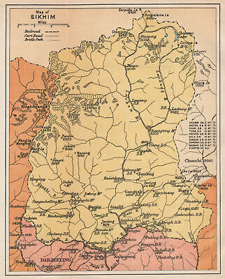
$10.04 Shipping Condition: Unspecified Location: LONDON, United Kingdom Map of Sikhim Antique colour travel map. 1929 Title of map: Map of Sikhim' The image below shows an enlarged cross section from the centre of the ... moremap to show the level of printed detail. This map is folding hence the centrefold line may show on the image below: DATE PRINTED: 1929 IMAGE SIZE: Approx 16.5 x 13.0cm. 6.5 x 5.25 inches(Small) Please note that this is a folding map. ARTIST/CARTOGRAPHER/ENGRAVER: Unsigned PROVENANCE: A Handbook for Travellers in India Burma and Ceylon" Published by Charles Scribner's Sons. New York: 13th Edition TYPE: Antique colour travel map VERSO: There is nothing printed on the reverse side. Which is plain CONDITION: Good; suitable for framing. However. Please note: The image shown may have been taken from a different example of this map than that which is offered for sale. The map you will receive is in good condition but there may be minor variations in the condition from that shown in the image. Please check the scan for any blemishes prior to making your purchase. Virtually all antiquarian maps and prints are subject to some normal aging due to use and time which is not obtrusive unless otherwise stated. I offer a no questions asked return policy- see below. AUTHENTICITY: This is an authentic historic print. Published at the date stated above. I do not offer reproductions. It is not a modern copy. The term'original' when applied to a print means that it was printed at the first or original date of publication; it does not imply that the item is unique. Print' means any image created by applying an inked block to paper or card under pressure by any method including wood engraving, steel engraving, copperplate, wood cut and lithography. REMARKS: FRANCE: Gravures et Cartes anciennes. DEUTSCHLAND: Alte Lankarten und Stadt ansichten. ITALIA: Stampe e Mappe antiche. ESPAÑA: Mapas antiquos y impresiones antiguas. E and OE. Force Majeure. English law shall apply. RETURNS POLICY: I offer a no questions returns policy. All I ask is that you pay return shippin
Buy It Now
$10.04 Shipping Condition: Unspecified Location: LONDON, United Kingdom Original 17th century copperplate map, 1683. DATE PRINTED: 1683. CONDITION: Good; suitable for framing. The map you will receive is in good condition ... morebut there may be minor variations in the condition from that shown in the image.
Buy It Now
$10.04 Shipping Condition: Unspecified Location: LONDON, United Kingdom Antique engraved sketch map, 1886. 'Curve of Volcanic Islands'. Title of map:'Curve of Volcanic Islands'. DATE PRINTED: 1886. TYPE: Antique engraved sketch ... moremap. The image below shows an enlarged cross section from the centre of the map to show the level of printed detail.
Buy It Now
$10.04 Shipping Condition: Unspecified Location: LONDON, United Kingdom Antique engraved sketch map, 1886. DATE PRINTED: 1886. TYPE: Antique engraved sketch map. The image below shows an enlarged cross section from the centre ... moreof the map to show the level of printed detail.
Buy It Now
$33.88 Shipping Condition: Unspecified Location: LONDON, United Kingdom PROVENANCE: "Stanford's London Atlas of Universal Geography", folio edition. London, Edward Stanford, Geographer to Her Majesty. Large (folio) antique ... moreatlas map, 1904. DATE PRINTED: 1904. Caption below picture:'Central Africa'.
Buy It Now
$10.04 Shipping Condition: Unspecified Location: LONDON, United Kingdom DATE PRINTED: Dieser plan wurde im jahre 1950 von Hermann Bollmann gezeichnet und in der 2 Auflage im jahre 1956 auf den neuesten stand gebracht. [This ... moreplan was drawn in 1950 by Hermann Bollmann and updated with a second edition in 1956].
Buy It Now
$10.04 Shipping Condition: Used Location: LONDON, United Kingdom 'Fisherman's Map of Salmon Pools on lower River Tay'. Caption below picture:'Fisherman's Map of Salmon Pools on lower River Tay'. Folding linen-backed ... moreleporello fisherman's map with hard cover, 1933. TYPE: Folding linen-backed leporello fisherman's map with hard cover.
Buy It Now
$10.04 Shipping Condition: Unspecified Location: LONDON, United Kingdom Antique colour map; Scale 1:25,000; Scale 1:12,900, 1905. DATE PRINTED: 1905. The image below shows an enlarged cross section from the centre of the map ... moreto show the level of printed detail. This map is folding hence the centrefold line may show on the image below.
Buy It Now
$10.04 Shipping Condition: Unspecified Location: LONDON, United Kingdom Antique colour map; Scale 1:17,500; Scale 1:250,000; Scale 1:20,000; Scale 1:175,000, 1909. DATE PRINTED: 1909. The image below shows an enlarged cross ... moresection from the centre of the map to show the level of printed detail.
Buy It Now
$10.04 Shipping Condition: Unspecified Location: LONDON, United Kingdom Title of map:'Rumania'. PROVENANCE: "The World-Wide Atlas of Modern Geography"; by J. Scott Keltie; published by W. & A.K. Johnston, London: 5th Edition ... more[World wide atlas]. Antique colour map, 1900. DATE PRINTED: 1900.
Buy It Now
$10.04 Shipping Condition: Unspecified Location: LONDON, United Kingdom 'Nubie' (De L'Afrique). Title of the map:'Nubie'. Original 17th century copperplate map, 1683. DATE PRINTED: 1683. Shows the Blue Nile, although it does ... morenot indicate its source in Lake Tana. It does not show the White Nile, the source of which was not discovered until the 19th century.
Buy It Now
$16.60 Shipping Location: Dover, United States Salem Marblehead Peabody Danvers 1897 lg. folding map Essex County Mass. Map of the City of Salem and Towns of Marblehead, Peabody and Danvers- Essex ... moreCounty Mass. Issued 1897, Salem, MA. by L.J. Richards & Co.
Buy It Now
$6.95 Shipping Location: Dover, United States Issued c. 1795-1806, Paris by Delamarche. Map by Vaugondy, revised and reissued by Delamarche. Engraved by Dussy. Late 18th/ early 19th century engraved ... moremap with original outline hand color.
|
|
|
|