|
|
Order by: Available to: This site contains affiliate links for which I may be compensated
|
Buy It Now
$10.04 Shipping Condition: Unspecified Location: LONDON, United Kingdom 'Walk 17th and St Leonards, Shoreditch'. Title of map:'Walk 17th and St Leonards, Shoreditch'. Antique engraved map, 1817. DATE PRINTED: 1817. CONDITION: ... moreGood; suitable for framing. TYPE: Antique engraved map.
Buy It Now
$10.04 Shipping Condition: Unspecified Location: LONDON, United Kingdom Antique atlas map, 1922. DATE PRINTED: 1922. Title of map:'China - Political '. 'China - Political'. The image below shows an enlarged cross section from ... morethe centre of the map to show the level of printed detail.
Buy It Now
$6.95 Shipping Location: Dover, United States Issued 1708, Amsterdam by De La Feuille. Early 18th century engraved map with attractive hand color. Le Duche de Milic Aves Ses Dependances. Map issued ... morefolded, and was backed on sturdy paper long ago.
Buy It Now
$6.95 Shipping Location: Dover, United States Milton - Adamsville - Unionville. Published 1871, New York, by F.W. Beers. Very detailed mid-19th century lithographed map, of great interest for historical ... moregenealogical purposes. Original center fold as issued.
Buy It Now
$10.04 Shipping Condition: Unspecified Location: LONDON, United Kingdom Ski/winter sports resorts marked on the map include: Wengen Mürren Grundelwald. 'Bernese Oberland'. Title of map (not printed on the page):'Bernese Oberland'. ... moreAntique colour map; Scale 1:250.000, 1911.
Buy It Now
$31.00 Shipping Location: Dover, United States C. Koeman- 1967, Amsterdam by Nico Israel. Consists of a 27 pp. Originally issued 1595, Amsterdam by Jodocus Hondius. This is a modern reproduction done ... morein a limited edition 1967.
Buy It Now
$10.04 Shipping Condition: Unspecified Location: LONDON, United Kingdom 'Fringing reefs between parahyba and the mouth of the S. Francisco'. Title of map:'Fringing reefs between parahyba and the mouth of the S. Francisco'. ... moreAntique wood-engraved map; Scale 1:3,500,500, 1885.
Buy It Now
$6.95 Shipping Location: Dover, United States Issued 1856, Edinburgh by William Blackwood and Sons. Engraved by W & A.K. Johnston. Detailed and lovely large mid 19th century color lithographed folio ... moremap with piano key border. Fine decorative appeal.
Buy It Now
$6.95 Shipping Location: Dover, United States Lovely antique map, engraved with original outline handcolor. Issued Paris, 1762 by Robert Vaugondy. Bel et Utile- Vaugondy Family of Mapmakers, 232, ... more7. (England / Wales / United Kingdom / Scotland).

Buy It Now
$10.04 Shipping Condition: Unspecified Location: LONDON, United Kingdom U.S. Coast survey Benjamin Peirce Superintendent North West Coast of America Sheet No.3 Icy bay to seven Islands 1868 Antique survey map chart; Scale ... more1:1200.000, 1871 Title of map: U.S. Coast survey Benjamin Peirce Superintendent North West Coast of America Sheet No.3 Icy bay to seven Islands 1868' The image below shows an enlarged cross section from the centre of the map to show the level of printed detail. This map is folding hence the centrefold line may show on the image below: DATE PRINTED: 1871 IMAGE SIZE: Approx 68.5 x 88.0cm. 27 x 34.5 inches(Large) Please note that this is a folding map. ARTIST/CARTOGRAPHER/ENGRAVER: United States Coast& Geodetic Survey PROVENANCE: Report of the Superintendent of the United States Coast Survey-1868" Published by Government Printing Office. Washington TYPE: Antique survey map chart; Scale 1:1200.000 VERSO: There is nothing printed on the reverse side. Which is plain CONDITION: Poor: Torn; The paper is brittle. Fragile, susceptible to tearing and at risk of loss from flaking. There may be small tears to the map and additional paper loss may have occurred compared to that shown in the scan. The map is incomplete- small parts of the map may be missing; see the scan. The map has split along part of one or more of the folds. Please note any other blemishes on the scan prior to purchasing this picture. Virtually all antiquarian maps and prints are subject to some normal aging due to use and time which is not obtrusive unless otherwise stated. I offer a no questions asked return policy- see below. AUTHENTICITY: This is an authentic historic print. Published at the date stated above. I do not offer reproductions. It is not a modern copy. The term'original' when applied to a print means that it was printed at the first or original date of publication; it does not imply that the item is unique. Print' means any image created by applying an inked block to paper or card under pressure by any method including wood engraving, steel engraving, copperplate, wood
Buy It Now
$10.04 Shipping Condition: Unspecified Location: LONDON, United Kingdom 'The World - Lemuria at its greatest extent'. Caption below picture:'The World - Lemuria at its greatest extent'. This map shows the supposed lost continent ... moreor island of Lemuria, centred around what is now the Indian Ocean, to illustrate the scriptures or theories of the theosophists, a quasi-religion established in New York City in 1875.
Buy It Now
$10.04 Shipping Condition: Used Location: LONDON, United Kingdom PROVENANCE: "Stanford's London Atlas of Universal Geography", folio edition. London, Edward Stanford, Geographer to Her Majesty. Large (folio) antique ... moreatlas map, 1896. DATE PRINTED: 1896. Caption below picture:'Greece'.
Buy It Now
$10.04 Shipping Condition: Unspecified Location: LONDON, United Kingdom Antique map; Scale 1:21,500, 1885. DATE PRINTED: 1885. CONDITION: Good; suitable for framing. The map you will receive is in good condition but there ... moremay be minor variations in the condition from that shown in the image.
Buy It Now
$10.04 Shipping Condition: Unspecified Location: LONDON, United Kingdom VERSO: There is another map printed on the reverse side. Antique colour military map, 1959. DATE PRINTED: 1959. DEUTSCHLAND: Alte Lankarten und Stadt ... moreansichten. ITALIA: Stampe e Mappe antiche. ESPA�A: Mapas antiquos y impresiones antiguas.
Buy It Now
$11.85 Shipping Location: Dover, United States Issued Issued 1764, Paris by Brion & Desnos. Interesting mid-18th century engraved map with original hand color heightened in outline. Original fold line ... moreas issued, light surface soiling and spotting.
Buy It Now
$6.95 Shipping Location: Dover, United States Issued 1753, Paris by Bellin. Mid 18th century engraved map with attractive hand color.
Buy It Now
$10.04 Shipping Condition: Unspecified Location: LONDON, United Kingdom 'Plan of Brighton'. Caption below picture:'Plan of Brighton'. PROVENANCE: "New Large Scale of the British Isles from the Ordnance Survey", George Bacon, ... more127 Strand London [Large Scale Ordnance Atlas - British Isles].

Buy It Now
$10.04 Shipping Condition: Unspecified Location: LONDON, United Kingdom The New World showing British Possessions and trade routes; European Colonization about 1800; The Colonial Empires at the present time Colour antique ... moremap. 1907 Title of map: The New World showing British Possessions and trade routes; European Colonization about 1800; The Colonial Empires at the present time' The image below shows an enlarged cross section from the centre of the map to show the level of printed detail. This map is folding hence the centrefold line may show on the image below: DATE PRINTED: 1907 IMAGE SIZE: Approx 53.5 x 36.5cm. 21 x 14.25 inches(Large) Please note that this is a folding map. ARTIST/CARTOGRAPHER/ENGRAVER: Unsigned PROVENANCE: The Harmsworth Atlas and Gazetteer" Published at Carmelite House, London. Please note that virtually all antique and vintage maps and prints have been extracted from books, atlases or newspapers. TYPE: Colour antique map VERSO: There are images and/or text printed on the reverse side of the picture. In some cases this may be visible on the picture itself(please check the scan prior to your purchase) or around the margin of the picture CONDITION: Good; suitable for framing. Please check the scan for any blemishes prior to making your purchase. Virtually all antiquarian maps and prints are subject to some normal aging due to use and time which is not obtrusive unless otherwise stated. I offer a no questions asked return policy- see below. AUTHENTICITY: This is an authentic historic print. Published at the date stated above. I do not offer reproductions. It is not a modern copy. The term'original' when applied to a print means that it was printed at the first or original date of publication; it does not imply that the item is unique. Print' means any image created by applying an inked block to paper or card under pressure by any method including wood engraving, steel engraving, copperplate, wood cut and lithography. REMARKS: FRANCE: Gravures et Cartes anciennes. DEUTSCHLAND: Alte Lankarten und Stadt ansichten. ITALIA: Stampe& Mappe antich
Buy It Now
$6.95 Shipping Location: Dover, United States Issued c. 1789, London. Engraved by Sparrow. (Old Prints, 18th Century Prints, Holy Roman Empire, Germany, Dresden, City View, Bridge, River Boats, Fortifications, ... moreChurches). Late 18th century engraved prospect city view of Dresden.
Buy It Now
$11.85 Shipping Location: Dover, United States Industry and Idleness. (Graphic Arts, Illustration, Hogarthian London, Industry & Idleness, Vice & Virtue, Print Lot). Nice lot of 9 engraved prints with ... morelovely hand color. Depicting a series of Hogarthian scenes representing industry and idleness in British society.
Buy It Now
$10.04 Shipping Condition: Unspecified Location: LONDON, United Kingdom 'AUSTRIAN DOMINIONS, III., Croatia, Sclavonia, and Dalmatia, with Index Map to the Empire of Austria'. Caption below picture:'AUSTRIAN DOMINIONS, III., ... moreCroatia, Sclavonia, and Dalmatia, with Index Map to the Empire of Austria'.
Buy It Now
$12.45 Shipping Location: Tinley Park, United States American etching artist. It was cut for Rand McNallys International Edition World Atlas in 1939. I believe page 284. This is not a page from atlas. He ... morewas a American etching artist, painter and commercial artist. Know for his maps, murals and book illustrations. Some of his murals were displayed at the 1933 Chicago Worlds Fair. Born in Alton, Il. Died Wilmette, Il. 14 x 11 inches. Shipped in frame to protect. Uv proof glass. No rips or damage.

Buy It Now
$10.04 Shipping Condition: Unspecified Location: LONDON, United Kingdom Baltic Sea Antique colour map. 1897 Title of map: Baltic Sea' The image below shows an enlarged cross section from the centre of the map to show the ... morelevel of printed detail: DATE PRINTED: 1897 IMAGE SIZE: Approx 21.5 x 28.0cm. 8.25 x 11 inches(Medium) ARTIST/CARTOGRAPHER/ENGRAVER: W. A.K. Johnston PROVENANCE: The World Wide Atlas of Modern Geography Political and Physical" by J. Scott Keltie; Published by W. A. K. Johnston. London: 3rd Edition TYPE: Antique colour map VERSO: There are images and/or text printed on the reverse side of the picture. In some cases this may be visible on the picture itself(please check the scan prior to your purchase) or around the margin of the picture CONDITION: Good; suitable for framing. However. Please note: The image shown may have been taken from a different example of this map than that which is offered for sale. The map you will receive is in good condition but there may be minor variations in the condition from that shown in the image which may include some light spotting. Please check the scan for any blemishes prior to making your purchase. Virtually all antiquarian maps and prints are subject to some normal aging due to use and time which is not obtrusive unless otherwise stated. I offer a no questions asked return policy- see below. AUTHENTICITY: This is an authentic historic print. Published at the date stated above. I do not offer reproductions. It is not a modern copy. The term'original' when applied to a print means that it was printed at the first or original date of publication; it does not imply that the item is unique. Print' means any image created by applying an inked block to paper or card under pressure by any method including wood engraving, steel engraving, copperplate, wood cut and lithography. REMARKS: FRANCE: Gravures et Cartes anciennes. DEUTSCHLAND: Alte Lankarten und Stadt ansichten. ITALIA: Stampe e Mappe antiche. ESPAÑA: Mapas antiquos y impresiones antiguas. E and OE. Force Majeure. English law shall apply. RETURNS POLICY:
Buy It Now
$10.04 Shipping Condition: Unspecified Location: LONDON, United Kingdom Sixth edition. Antique colour map, 1898. DATE PRINTED: 1898. TYPE: Antique colour map.
Buy It Now
$33.88 Shipping Condition: Used Location: LONDON, United Kingdom [The coastline of Waterford, Wexford and Wicklow with an inset map of Dublin and Dublin Bay]. Caption below picture:45: '[The coastline of Waterford, ... moreWexford and Wicklow with an inset map of Dublin and Dublin Bay]'.
Buy It Now
$10.04 Shipping Condition: Unspecified Location: LONDON, United Kingdom Large antique early 19th century atlas wall map with original hand colouring, on four sheets, unjoined, 1817. DATE PRINTED: Published in 1817. Engraved ... morein 1816; this date is marked on the map. AUTHENTICITY: This is an authentic historic print, published at the date stated above.
Buy It Now
$10.04 Shipping Condition: Unspecified Location: LONDON, United Kingdom Antique colour map; Scale 1:20,000, 1909. DATE PRINTED: 1909. The image below shows an enlarged cross section from the centre of the map to show the level ... moreof printed detail TYPE: Antique colour map; Scale 1:20,000.
Buy It Now
$10.04 Shipping Condition: Unspecified Location: LONDON, United Kingdom 'Willesden'. Title of map:'Willesden'. DATE PRINTED: 1935. CONDITION: Good; suitable for framing.
Buy It Now
$10.04 Shipping Condition: Unspecified Location: LONDON, United Kingdom 'Moscow - centre'. Title of map:'Moscow - centre'. DATE PRINTED: 1929. PROVENANCE: "Guide-Book to The Soviet Union"; complied by A. Radó, published by ... moreNeuer Deutscher Verlag, Berlin. 1st edition. The image below shows an enlarged cross section from the centre of the map to show the level of printed detail.
Buy It Now
$10.04 Shipping Condition: Used Location: LONDON, United Kingdom Antique colour map; Scale 1:5,000,000, 1885. DATE PRINTED: 1885. The image below shows an enlarged cross section from the centre of the map to show the ... morelevel of printed detail. This map is folding hence the centrefold line may show on the image below.
Buy It Now
$10.04 Shipping Condition: Unspecified Location: LONDON, United Kingdom Published as the Act directs, 1 Feb 1776, London. 'County of Londonderry'. Title of map:'County of Londonderry'. Antique copperplate map with original ... morehand colour, 1776. TYPE: Antique copperplate map with original hand colour.
Buy It Now
$10.04 Shipping Condition: Unspecified Location: LONDON, United Kingdom Antique copperplate map, 1759. DATE PRINTED: 1759. CONDITION: Good; suitable for framing. The map you will receive is in good condition but there may ... morebe minor variations in the condition from that shown in the image.
Buy It Now
$10.04 Shipping Condition: Used Location: LONDON, United Kingdom 'Buckinghamshire'. Caption below picture:'Buckinghamshire'. Antique colour lithographic map, 1898. DATE PRINTED: 1898. TYPE: Antique colour lithographic ... moremap.
Buy It Now
$10.04 Shipping Condition: Unspecified Location: LONDON, United Kingdom Antique copperplate engraved map, 1780. DATE PRINTED: 1780. DEUTSCHLAND: Alte Lankarten und Stadt ansichten. ITALIA: Stampe e Mappe antiche. ESPAÑA: Mapas ... moreantiquos y impresiones antiguas. Force Majeure.
Buy It Now
$10.04 Shipping Condition: Used Location: LONDON, United Kingdom Antique map with original outline colour, 1863. DATE PRINTED: 1863. CONDITION: Good; suitable for framing. The map you will receive is in good condition ... morebut there may be minor variations in the condition from that shown in the image.
Buy It Now
$10.04 Shipping Condition: Unspecified Location: LONDON, United Kingdom VERSO: There is another map printed on the reverse side. Antique colour military map, 1959. DATE PRINTED: 1959. DEUTSCHLAND: Alte Lankarten und Stadt ... moreansichten. ITALIA: Stampe e Mappe antiche. ESPA�A: Mapas antiquos y impresiones antiguas.
Buy It Now
$10.04 Shipping Condition: Unspecified Location: LONDON, United Kingdom 'Plan of Underground workings The Charlotte Plains Consolidated Gold Mines, Limited, Parish of Eddington'. Title of map:'Plan of Underground workings ... moreThe Charlotte Plains Consolidated Gold Mines, Limited, Parish of Eddington'.
Buy It Now
$10.04 Shipping Condition: Unspecified Location: LONDON, United Kingdom 'La Rochelle'. Title of the map:'La Rochelle'. Antique colour map; Scale 1:16.000, 1914. DATE PRINTED: 1914. The image below shows an enlarged cross section ... morefrom the centre of the map to show the level of printed detail.

Buy It Now
$10.04 Shipping Condition: Unspecified Location: LONDON, United Kingdom Philippine Islands(To Spain) Tasmania; North Borneo Brunei& Sarawak Antique colour map. 1897 Title of map: Philippine Islands(To Spain) Tasmania; ... moreNorth Borneo Brunei& Sarawak' The image below shows an enlarged cross section from the centre of the map to show the level of printed detail: DATE PRINTED: 1897 IMAGE SIZE: Approx 20.0 x 27.0cm. 8 x 10.75 inches(Medium) ARTIST/CARTOGRAPHER/ENGRAVER: W. A.K. Johnston PROVENANCE: The World Wide Atlas of Modern Geography Political and Physical" by J. Scott Keltie; Published by W. A. K. Johnston. London: 3rd Edition TYPE: Antique colour map VERSO: There are images and/or text printed on the reverse side of the picture. In some cases this may be visible on the picture itself(please check the scan prior to your purchase) or around the margin of the picture CONDITION: Good; suitable for framing. However. Please note: The image shown may have been taken from a different example of this map than that which is offered for sale. The map you will receive is in good condition but there may be minor variations in the condition from that shown in the image which may include some light spotting. Please check the scan for any blemishes prior to making your purchase. Virtually all antiquarian maps and prints are subject to some normal aging due to use and time which is not obtrusive unless otherwise stated. I offer a no questions asked return policy- see below. AUTHENTICITY: This is an authentic historic print. Published at the date stated above. I do not offer reproductions. It is not a modern copy. The term'original' when applied to a print means that it was printed at the first or original date of publication; it does not imply that the item is unique. Print' means any image created by applying an inked block to paper or card under pressure by any method including wood engraving, steel engraving, copperplate, wood cut and lithography. REMARKS: FRANCE: Gravures et Cartes anciennes. DEUTSCHLAND: Alte Lankarten und Stadt ansichten. ITALIA: Stampe e Mappe anti

Buy It Now
$10.04 Shipping Condition: Unspecified Location: LONDON, United Kingdom Savannah Antique colour map; Scale 1:15.000. 1909 Title of the map: Savannah' The image below shows an enlarged cross section from the centre of the ... moremap to show the level of printed detail: DATE PRINTED: 1909 IMAGE SIZE: Approx 15.0 x 10.0cm. 5.75 x 4 inches(Small) ARTIST/CARTOGRAPHER/ENGRAVER: Wagner& Debes PROVENANCE: The United States with excursions to Mexico. Cuba, Porto Rico, and Alaska" by Karl Baedeker, Published by Karl Baedeker, London: 4th Edition TYPE: Antique colour map; Scale 1:15.000 VERSO: There is nothing printed on the reverse side. Which is plain CONDITION: Good; suitable for framing. However. Please note: The image shown may have been taken from a different example of this map than that which is offered for sale. The map you will receive is in good condition but there may be minor variations in the condition from that shown in the image. Please check the scan for any blemishes prior to making your purchase. Virtually all antiquarian maps and prints are subject to some normal aging due to use and time which is not obtrusive unless otherwise stated. I offer a no questions asked return policy- see below. AUTHENTICITY: This is an authentic historic print. Published at the date stated above. I do not offer reproductions. It is not a modern copy. The term'original' when applied to a print means that it was printed at the first or original date of publication; it does not imply that the item is unique. Print' means any image created by applying an inked block to paper or card under pressure by any method including wood engraving, steel engraving, copperplate, wood cut and lithography. REMARKS: FRANCE: Gravures et Cartes anciennes. DEUTSCHLAND: Alte Lankarten und Stadt ansichten. ITALIA: Stampe e Mappe antiche. ESPAÑA: Mapas antiquos y impresiones antiguas. E and OE. Force Majeure. English law shall apply. RETURNS POLICY: I offer a no questions returns policy. All I ask is that you pay return shipping and mail back to me in original condition. Suitably packed& insured
Buy It Now
$10.04 Shipping Condition: Unspecified Location: LONDON, United Kingdom 'Central Edinburgh'. Title of map:'Central Edinburgh'. PROVENANCE: Ward Lock Red Guides. DATE PRINTED: 1922. The image below shows an enlarged cross section ... morefrom the centre of the map to show the level of printed detail.
Buy It Now
$10.04 Shipping Condition: Unspecified Location: LONDON, United Kingdom Antique colour map, 1898. DATE PRINTED: 1898. CONDITION: Good; suitable for framing. The map you will receive is in good condition but there may be minor ... morevariations in the condition from that shown in the image.
Buy It Now
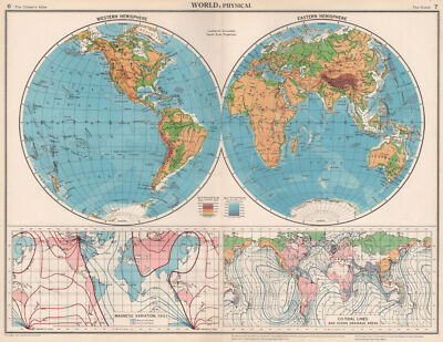
$10.04 Shipping Condition: Unspecified Location: LONDON, United Kingdom World. Physical; Western Hemisphere; Eastern Hemisphere; Magnetic Variation, 1951; Co-Tidal lines and Ocean Drainage Areas Vintage colour map. 1952 Title ... moreof map: World. Physical; Western Hemisphere; Eastern Hemisphere; Magnetic Variation, 1951; Co-Tidal lines and Ocean Drainage Areas' The image below shows an enlarged cross section from the centre of the map to show the level of printed detail. This map is folding hence the centrefold line may show on the image below: DATE PRINTED: 1952 IMAGE SIZE: Approx 34.0 x 44.5cm. 13.5 x 17.5 inches(Large) Please note that this is a folding map. ARTIST/CARTOGRAPHER/ENGRAVER: John Bartholomew PROVENANCE: The Citizen's Atlas of the World" by John Bartholomew; Published by John Bartholomew& Son limited. Edinburgh; 10th Edition. Please note that virtually all antique and vintage maps and prints have been extracted from books, atlases or newspapers. TYPE: Vintage colour map VERSO: There is another map or maps printed on the reverse side of the picture. The paper is thick. And the printing on the reverse does not show through to the front CONDITION: Good; suitable for framing. However. Please note: The image shown may have been taken from a different example of this map than that which is offered for sale. The map you will receive is in good condition but there may be minor variations in the condition from that shown in the image. Please check the scan for any blemishes prior to making your purchase. Virtually all antiquarian maps and prints are subject to some normal aging due to use and time which is not obtrusive unless otherwise stated. I offer a no questions asked return policy- see below. AUTHENTICITY: This is an authentic historic print. Published at the date stated above. I do not offer reproductions. It is not a modern copy. The term'original' when applied to a print means that it was printed at the first or original date of publication; it does not imply that the item is unique. Print' means any image created by applying an inked block to pa
Buy It Now
$10.04 Shipping Condition: Unspecified Location: LONDON, United Kingdom Antique 18th century copperplate map, 1788. DATE PRINTED: 1788. The image below shows an enlarged cross section from the centre of the map to show the ... morelevel of printed detail. This map is folding hence the centrefold line may show on the image below.
Buy It Now
$10.04 Shipping Condition: Unspecified Location: LONDON, United Kingdom The map depicts the Greek Ionian island of Zakynthos. The map is orientated towards the north. Antique copperplate map, 1590. DATE PRINTED: 1590. PROVENANCE: ... more"L'Isole Piu Famose del Mondo", Venice.
Buy It Now
$10.04 Shipping Condition: Unspecified Location: LONDON, United Kingdom Most of the plates used for this atlas were original engraved for the SDUK atlas in the mid nineteenth century. Antique colour atlas map, 1884. DATE PRINTED: ... more1884. CONDITION: Good; suitable for framing.
Buy It Now
$10.04 Shipping Condition: Unspecified Location: LONDON, United Kingdom PROVENANCE: "Report of the Boundary Commissioners for England and Wales", 1868. printed by George Edward Eyre & William Spottiswoode, for Her Majesty's ... moreStationery Office, London. DATE PRINTED: 1868. DEUTSCHLAND: Alte Lankarten und Stadt ansichten.
Buy It Now
$10.04 Shipping Condition: Unspecified Location: LONDON, United Kingdom The map includes the towns of Waterford, Kilmacthomas and covers part of the county of Waterford. DATE PRINTED: 1778.
Buy It Now
$10.04 Shipping Condition: Unspecified Location: LONDON, United Kingdom 'The War in North Africa - The Allied Invasion - General Map'. Title of map:'The War in North Africa - The Allied Invasion - General Map'. Antique colour ... moremilitary map, 1959. DATE PRINTED: 1959. Chief Editor Colonel Vincent J. Esposito.
Buy It Now
$10.04 Shipping Condition: Unspecified Location: LONDON, United Kingdom PROVENANCE: "Poates Highway and Regional guide of the United States"; published by Poates Corporation, 4 Washington Place, New York [Poates United States ... moreguide]. DATE PRINTED: 1925. The image below shows an enlarged cross section from the centre of the map to show the level of printed detail.
Buy It Now
$10.04 Shipping Condition: Unspecified Location: LONDON, United Kingdom PROVENANCE: "The War in the Air"; by H.A. Jones; Published by the Clarendon press 1937, Oxford. DATE PRINTED: 1937. CONDITION: Good; suitable for framing. ... moreThe image below shows an enlarged cross section from the centre of the map to show the level of printed detail.
Buy It Now
$33.88 Shipping Condition: Used Location: LONDON, United Kingdom PROVENANCE: "P. Bertii - Tabularum Geographicarum Contractarum", Libri Quinque. Editio Secunda. Apud Cornelium Nicolai, Anno 1603. Descriptio Indiae Orientalis ... more/ India Orien [East Indies / East Asia].
Buy It Now
$10.04 Shipping Condition: Unspecified Location: LONDON, United Kingdom Antique colour wine region map, 1976. TYPE: Antique colour wine region map. DATE PRINTED: 1976. AUTHENTICITY: This is an authentic historic print, published ... moreat the date stated above. It is not a modern copy.
Buy It Now
$10.04 Shipping Condition: Unspecified Location: LONDON, United Kingdom Title of map:'Torino'. DATE PRINTED: 1924. The image below shows an enlarged cross section from the centre of the map to show the level of printed detail. ... moreThis map is folding hence the centrefold line may show on the image below.
Buy It Now
$10.04 Shipping Condition: Unspecified Location: LONDON, United Kingdom 'Environs of Garmisch-Partenkirchen & Mittenwald'. Title of map (not printed on the page):'Environs of Garmisch-Partenkirchen & Mittenwald'. DEUTSCHLAND: ... moreAlte Lankarten und Stadt ansichten. ITALIA: Stampe e Mappe antiche.
Buy It Now
$10.04 Shipping Condition: Unspecified Location: LONDON, United Kingdom 'Bautzen' (The environs of the Czorneboh). Title of map:'Bautzen'. Antique colour travel map; Scale 1:20.000; Scale 1:100.000, 1904. DATE PRINTED: 1904. ... moreThe image below shows an enlarged cross section from the centre of the map to show the level of printed detail.
Buy It Now
$10.04 Shipping Condition: Unspecified Location: LONDON, United Kingdom Antique steel engraved map with original outline hand colouring (coloring), 1844. This edition of the map was printed and published by Charles Knight ... morein 1844. 'EASTERN SIBERIA'. Caption below picture:'EASTERN SIBERIA'.

Buy It Now
$10.04 Shipping Condition: Unspecified Location: LONDON, United Kingdom The Frankish Dominions in Merovingian times 486-768; Inset maps of Partition of 511 on Chlodovech's death; Partition of 561 on Chlothachar's death; ... morePartition of 587; Partition of 625 Antique colour map. 1902 Title of map: The Frankish Dominions in Merovingian times 486-768; Inset maps of Partition of 511 on Chlodovech's death; Partition of 561 on Chlothachar's death; Partition of 587; Partition of 625' The image below shows an enlarged cross section from the centre of the map to show the level of printed detail: DATE PRINTED: 1902 IMAGE SIZE: Approx 25.0 x 32.5cm. 9.75 x 12.75 inches(Large) ARTIST/CARTOGRAPHER/ENGRAVER: Unsigned PROVENANCE: Historical Atlas of Modern Europe" Edited by Reginald Lane Poole. Published by Henry Frowde, London. Please note that virtually all antique and vintage maps and prints have been extracted from books, atlases or newspapers. TYPE: Antique colour map VERSO: There is nothing printed on the reverse side. Which is plain CONDITION: Good; suitable for framing. However. Please note: The image shown may have been taken from a different example of this map than that which is offered for sale. The map you will receive is in good condition but there may be minor variations in the condition from that shown in the image. Please check the scan for any blemishes prior to making your purchase. Virtually all antiquarian maps and prints are subject to some normal aging due to use and time which is not obtrusive unless otherwise stated. I offer a no questions asked return policy- see below. AUTHENTICITY: This is an authentic historic print. Published at the date stated above. I do not offer reproductions. It is not a modern copy. The term'original' when applied to a print means that it was printed at the first or original date of publication; it does not imply that the item is unique. Print' means any image created by applying an inked block to paper or card under pressure by any method including wood engraving, steel engraving, copperplate, wood cut and lithog
Buy It Now
$11.85 Shipping Location: Dover, United States Issued 1743, Nuremberg, Germany by the Heirs of Homann. Large decorative mid-18th century antique map. Engraved with original hand color.
Buy It Now
$6.95 Shipping Location: Dover, United States Issued 1760, London by Em. A New and Accurate Map of Denmark. Attractive mid 18th century engraved map. Inset vignette depicts a pair of horses in a field.
|
|
|
|