|
|
Order by: Available to: This site contains affiliate links for which I may be compensated
|
Buy It Now
$15.00 Shipping Location: Brooklyn, United States Bid with confidence from a seller with 100% positive feedback. Johnson's Spain and Portugal. By A.J. Johnson You are bidding on an original antique ... moremap of the Iberian Peninsula including Spain and Portugal with an inset of Gibraltar from an 1861 edition of Johnson's New Illustrated Family Atlas. This map is in very good condition with some browning from age and a few brown spots. The dimensions of this map are approximately 16 in. x 13 in. All maps sold by Globetrader Rare Maps are guaranteed to be authentic. We do not sell reproductions. We will ship this map flat with stiff foamboard to protect it from damage. WE COMBINE SHIPPING TO SAVE YOU MONEY SKU M10568,
Buy It Now
$15.00 Shipping Location: Brooklyn, United States TITLE JOHNSON'S SPAIN AND PORTUGAL DATE-1864 ISSUED AND PUBLISHED BY JOHNSON AND WARD FROM THE 1864 JOHNSON'S NEW ILLUSTRATED STEEL PLATE FAMILY ... moreATLAS THIS AUCTION IS FOR AN ORIGINAL 1864 HAND-COLORED JOHNSON AND WARD ATLAS MAP OF SPAIN AND PORTUGAL. MAP SHOWS MANY TOWNSHIPS AS WELL AS ALL RAILROAD ROUTES. INSET MAP AT LOWER RIGHT OF GIBRALTAR. MEASURES 14 X 18 INCHES FAIR-GOOD CONDITION

Buy It Now
$15.00 Shipping Location: Brooklyn, United States 1865 Johnson Map of South America WE SELL ONLY ORIGINAL ANTIQUE MAPS- NOT REPRODUCTIONS Title: Johnson's South America. Description: This is a beautiful ... moreexample of Johnson and Ward's 1865 map of South America. It covers the entire continent from the Caribbean to Tierra del Fuego and from the Pacific to the Atlantic. Including the Falkland and South Georgia island groups. Features the continent in considerable detail- especially the Amazon interior, which at the time was largely unknown. Various towns, cities, rivers and several other topographical features are noted with relief shown by hachures. It features the fretwork style border common to Johnson’s atlas work from 1864 to 1869. Published by A. J. Johnson and Ward as plate nos. 72 and 73 in the 1865 edition of Johnson’s New Illustrated Family Atlas. This is the first edition of the Johnson Atlas to be attributed to Johnson exclusively. Map is dated and copyrighted, Entered according to Act of Congress in the Year of 1863 by A. J. Johnson in the Clerk’s Office of the District Court of the United States for the Southern District of New York' Size: Printed area measures 23 inches high by 17 inches wide. Condition: Very good. Text on verso. Minor wear along original centerfold. Shipping: Items are shipped within three business days of receiving payment. We are happy to consolidate shipping where possible. The following shipping options are available: 1. USPS Domestic Express Mail(25 USD) USA Only. 2. USPS Priority Mail(12 USD) USA Only. 3. USPS International Express(35 to 55 USD) Recommended service for all international parcels. 4. USPS Priority Mail(25 USD) Available to only certain countries. Due to high instances of loss. This service is specifically NOT AVAILABLE to MAINLAND CHINA or INDIA. 5. Federal Express is available upon request. This is the only service option available to India and Africa. Price is quoted upon request following the auction. We can also use your Federal Express Account. Insurance: All shipments are insured privately again
Buy It Now
$6.80 Shipping Location: Santa Barbara, United States A.J. Johnson. A.J. Johnson, New York. 1880 Antique USGS Progress Map, George Wheeler. 1829 Antique Map of The County of Sussex. 1829 Antique Map of The ... moreCounty of Surrey. You might also like. PICK UP OPTION.
Buy It Now
$6.80 Shipping Location: Santa Barbara, United States This is a colorful map from Johnson's Atlas showing great detail of Austria, Turkey, and Greece. A.J. Johnson. A.J. Johnson, New York. 1880 Antique USGS ... moreProgress Map, George Wheeler. 1829 Antique Map of The County of Sussex.

Buy It Now
$15.00 Shipping Location: Brooklyn, United States Lake Erie Maps& Prints! An Original Antique Map: Not a Reproduction! See Our Ebay Store for More! Free Shipping on Purchases of 5 or More Maps and ... morePrints Description: It is an authentic engraved antique Pre-Civil War era map approximately 150 years old with original handcoloring as issued. It is from the 1862 Edition of Johnson's Family Atlas. A copy of the title page is included for authenticity. It is not matted. Mounted nor framed being sold as a single sheet as shown in the main pic. Overall a very nice map in great condition that would frame up beautifully with an antique appearance as desired. Size: The map image measures approximately 16 by 24 inches on a 18 by 26 1/2" 46x67cm) page with a margin all around for framing. Condition: The map is in Excellent condition for its age with overall tonal aging. Printed on a heavy page with original hand color and a centerfold as issued. The pics are of the actual map. Payment Details: We accept most major credit cards through Paypal and Ebay. Please ask if you have any questions about payment. International and New Bidders are welcomed and encouraged. Payment is expected within 7 days. After which Nonpaying Bidders will be reported to Ebay to recoup our listing fees. Save on Shipping: We only charge one shipping fee based on the largest map or print with multiple items shipped along with it for no extra costs. Purchase 5 or more maps or prints and receive Free First Class shipping in USA or First Class International elsewhere in the world. Although registration may be required on shipments of high value. International Customs and VAT Fees: It is the responsibility of the buyer to pay all Customs Taxes. VAT or other fees that may be due upon arrival. These fees vary greatly from country to country and ebay policy is that the buyer is responsible for their country's taxes and fees. Please consult your country's Customs Regulations for more details on your country, printed matter is duty free in many countries. We declare the full purchase value as

Buy It Now
$16.23 Shipping Location: New York, United States 1861 Johnson and Browning Map of Australia(First Edition) WE SELL ONLY ORIGINAL ANTIQUE MAPS- NOT REPRODUCTIONS Title: Johnson's Australia. Description: ... moreA beautiful first edition example of A. J. Johnson’s 1861 map of Australia. This is the first edition and earliest state in the Johnson Australia series. Depicts the continent with good detail along the coast and a largely unexplored interior. Shows the Torrens Basin. The Stony Desert, Traveler's Valley, and the extant of Sturt's inland exploration. Tables in the corners show references to various counties in each provinces. A smaller table in the lower left provides a time line for the exploration of the continent, noting the dates associated with important navigators including Tasman, Arnhem, Hartog, Edel, Flinders, and others. Features the strapwork style border common to Johnson’s atlas work from 1860 to 1863. Published by A. J. Johnson and Browning as plate number 88 in the 1861 edition of Johnson’s New Illustrated Family Atlas. Though Johnson did print an 1860 edition of his atlas, it did not contain a specific Australia map. This is the last edition of the Family Atlas to bear the Johnson and Browning imprint. Size: Printed area measures 13.5 inches high by 15.5 inches wide. Condition: Very good condition. Light overall toning. Blank on verso. Shipping: Due to recent increases in United States Postal Service rates we have been forced to increase our shipping rates. Shipping rates are not negotiable. Items are shipped within three business days of receiving payment. We are happy to consolidate shipping where possible. The following shipping options are available: 1. USPS Domestic Express Mail(35 USD) USA Only. 2. USPS Priority Mail(15 USD) USA Only. 3. USPS International Express(35 to 55 USD) Recommended service for all international parcels. You will be invoiced at the lowest Express Mail rate possible. 4. USPS Priority Mail(35 USD) Available to only certain countries. Due to high instances of loss. This service is specifically NOT AVAILABLE to
Buy It Now
Free Shipping Location: West Yellowstone, United States Title: BRISTOL CHANNEL, Map XIV, Page 193, Vol. II ; England Map XIX. Size: Page 9.75" x 11"; Map 7.5" x 9.". Folds: One, at center.
Buy It Now
$10.00 Shipping Location: Cyprus Detailed and beautiful full hand colored early example of Johnsons map of Cuba, Jamaica the Bahamas and Puerto Rica in excellent condition. Origin: Colton's ... moreGeneral Atlas published by Johnson and Browning 1859.
Buy It Now
$4.15 Shipping Location: Saco, United States The Outer Edge or the Map will have Browning, Smudges and/or Stains. Any and all other blemishes will be shown in photos.

Buy It Now
$4.99 Shipping Location: Fairview, United States Click Here. Double your traffic. Get Vendio Gallery- Now FREE! Lake Erie Maps& Prints! An Authentic Antique Map: Not a Modern Reproduction! See Our ... moreEbay Store for More! Free Shipping on Purchases of 5 or More Maps and Prints Description: It is an authentic antique map approximately 140 years old with a centerfold and original handcoloring as issued. It is from an 1872 edition of Asher& Adams' Topographical Atlas of the United States(New York: Asher& Adams. 1872) a copy of the title page is included for authenticity. There is a copyright in small print in the bottom margins stating"Entered according to Act of Congress in the year 1872 by Asher& Adams. It is not matted nor framed being sold as a single sheet as shown in the main pic, blank on the reverse. Overall, a very nice map that would frame up nicely. It is a fairly scarce map in a large elephant folio format that is very detailed for the period rivaling the more common Johnson atlas of the period in terms of detail, size and color. Overall a very nice map that would frame up well. Size: The dimensions of the map area between the neat lines measures 16 by 22 inches(41x56cm) on a page measuring 17 1/2 by 24 1/4" 44x62cm) with a margin all around as seen in the main pic. Condition: The map is in Good condition with overall tonal ageing. Original hand coloring, blank on the reverse, printed on a heavy page. There is a two inch split at the top of the centerfold, some darkening around the edges and a few minor spots as seen in the pics, see the pic for more on condition. There are a couple of old repairs on the reverse along the top and bottom centerfold. The actual map looks better than the pics. The pics are of the actual map. Payment Details: We accept most major credit cards through Paypal and Ebay. Please ask if you have any questions about other forms of payment. International and New Bidders are welcomed and encouraged. Payment is expected within 7 days. After which Nonpaying Bidders will be reported to Ebay to recoup our list
Buy It Now
$10.00 Shipping Location: Montrose, United States Colton established his firm in New York in 1831. Colton completed the contract, but was not paid by the Bolivians, where they were in the throws of a ... morerevolution. Joseph Hutchins Colton (July 5, 1800 – July 29, 1893), known professionally asJ.H.
Buy It Now
Free Shipping Location: San Diego, United States 1862 RARE JOHNSON'S BEAUTIFUL ANTIQUE ATLAS MAP OF CHINA-HANDCOLORED-BORDER, Click to View Image Album 1862 RARE JOHNSON'S BEAUTIFUL ANTIQUE ATLAS ... moreMAP OF CHINA-HANDCOLORED-BORDER BEAUTIFUL DETAILED JOHNSON'S ATLAS MAP PLEASE SEE PHOTOS AS PART OF THE DESCRIPTION CONDITION: MAP IS IN GOOD CONDITION WITH NICE BORDER- SOME SMALL EDGE TEARS SIZE: APPROXIMATELY 14" X 17" SHIPPING: U.S. FIRST CLASS RATE- $4.00. CANADA- $7.00. WORLDWIDE- $14.00 THANK YOU FOR YOUR INTEREST IN OUR AUCTIONS Payment I accept the following forms of payment: PayPal Shipping& Handling $5.00 USPS First-Class Mail® FREE scheduling. Supersized images and templates. Get Vendio Sales Manager. FREE scheduling. Supersized images and templates. Get Vendio Sales Manager. Over 100.000,000 served. Get FREE counters from Vendio today!
Buy It Now
$5.00 Shipping Location: Prairieville, United States There are nice city views of 1862 Amsterdam & Brussels in the upper left quadrant. Closeup of Engravings of Amsterdam & Brussels. Closeup of the Brussels ... moreEngraving. Closeup of area around Brussels. ATTRACTIVE 1862 JOHNSON MAP of HOLLAND & BELGIUM.
Buy It Now
$7.87 Shipping Location: Medina, United States Bright hand colored map shows mountains, waterways and lakes in nice condition. This attractive image map is surrounded by an elegant border. Very good ... morecondition with slight age toning.

Buy It Now
$7.00 Shipping Location: North Wales, United States Vintage HandColored Map 1 FULL Page Removed From Vintage Atlas( NOT a Reproduction/ Facsimile) = NO REPRO Please View the 2 Images BELOW Regio ns: New ... moreBru nswick and Nov a Scoti a and Newfoundland and Prince Edward Island( PEI) Inset Map: non e MAP Copyri ght Date: none Size of Entire Page: 13.75 x 18 inches Size of Geometric Border: 12.5 x 15.5 inches Size of Rectangular MAP AREA: 11.11 x 14 inches Source: Atlas: Jo hns on's Family Atlas Cartographers: AJ Johnson and JH Colton Publisher: Johnson and Browning/ New York NY Date Entire ATLAS Published: 1864 Plate Number: 19 Verso/ Back of Page: Text( NOT Visible) FLAWS NOT Visible in the Image Below: 1 inch diagonal closed tear along left edge in Margin ONLY some short closed tears along edge where removed from atlas in Margin ONLY NOTE: Image Shown is PARTIALLY CROPPED Item You Will Receive is an Entir e Page Ready to be Framed and/or Matted Fine Print: USPS Shipping Fees( First Class/ Priority Mail) Can Be Calculated Above. will COMBINE Shipments Whenever Possible to Reduce Shipping Fee) Insurance Available AT COST- Please Let Us Know IF Desired. M aps Shipped Gently ROLLED in a 3 mil. Plastic Sleeve in a Sturdy CardBoard Tube(3-Inch Diameter- See Below) NO Handling Fees and QUICK Handling Time! SAFE Packaging. We Accept PayPal ONLY. Mass. Residents MUST Add 6.25% Sales Tax. Do NOT Ship Any Items Outside the U.S.A. this includes APOs/FPOs. NOTES: Scans and Photos Below are of the EXACT Item(s) You Will Receive Auctions: Will Not End Early Buy It Now Items: Will Not Entertain Offers(Unless"Best Offer" Link Present) Have Been Selling on eBay Since 2004 View the other Vintage and Antique Images in our eBay Store by Clicking on the Link Below: The Paper Merchant eBay Store Thanks For Looking! Photo is the EXACT Item You Will Receive B&W PhotoCopy of Title Page BELOW Included with THIS Lot keywords: antique map. Antique maps, antique atlas, antique atlases, antique plate, antique plates, antique engraving, antique engravings, antiqu
Buy It Now
$7.00 Shipping Location: North Wales, United States 1866 ANTIQUE JOHNSON ATLAS MAP OF CENTRAL AMERICA-HAND COLORED ORIGINAL ANTIQUE ATLAS MAP PLEASE SEE PHOTOS AS PART OF THE DESCRIPTION CONDITION: MAP ... moreIS IN GOOD CONDITION. SIZE: APPROXIMATELY 10" X 13" SHIPPING: U.S. FIRST CLASS RATE - $7.00 - ANY ITEM WHICH SELLS FOR OVER $100 WILL REQUIRE INSURANCE WE COMBINE SHIPPING FOR MULTIPLE WINS. THANK YOU FOR YOUR INTEREST IN OUR AUCTIONS!.

$10.00 Shipping Location: Roanoke, United States An ORIGINAL antique 1860 map of SWITZERLAND from JOHNSON'S New Illustrated FAMILY ATLAS. Cantons are individually HAND WATERCOLORED while a few early ... morerailroads. And scores of stagecoach roads are shown. Among the finest maps produced during the 19th Century. Johnson's maps were used extensively during the Civil War. The map measures 14 by 18 inches and is perfect for matting and framing. This ORIGINAL antique map is guaranteed over 145 years old, published during the CIVIL WAR. Note there is a very light waterstain at the lower right corner. I do not sell reproductions, just honest maps at honest prices. Discounted shipping too. NO international shipping. NO exceptions. All items shipped within 2 business days after payment. If you have not received an item in a reasonable amount of time please email me. It has been delayed by the Post Office. I also accept returns on ANY item for ANY reason, please email me I am very easy to work with. Feedback is not the same thing as an email, please email first. On Oct-19-07 at 13:06:06 PDT. Seller added the following information:
Buy It Now
$4.15 Shipping Location: Saco, United States Up for Sale is a Beautiful Colored Map of England & Wales with Colored Regions.This Single Sheet (double page) Atlas Map was Extracted by Myself from ... morean 1867 A. J. Johnson's Family Atlas. The Outer Edge or the Map will have Browning, Smudges and/or Stains.
Buy It Now
$4.15 Shipping Location: Saco, United States Up for Sale is a Beautiful 1867 Colored Map of Austria, Greece and Turkey.This Single Sheet Double Page Atlas Map was Extracted by Myself from an 1867 ... moreA. J. Johnson's Family Atlas. The Outer Edge or the Map will have Browning, Smudges and/or Stains.
Buy It Now
$6.80 Shipping Location: Eagle, United States Presented is an authentic, old map taken from Johnson's Family Atlas published in 1864. Original hand color. Condition reflects lower price.
Buy It Now
$3.50 Shipping Location: Winter Springs, United States Also printed at bottom is Engraved, & Printed by W.K. & A.K. Johnsons, Edinburgh. The map is very detailed. This is from the rare 1871 Royal Atlas of ... moreKeith Johnston. Johnston was the Royal Geographer.

Buy It Now
Free Shipping Location: Syracuse, United States Lake Erie Maps& Prints! An Original Antique Map: Not a Reproduction! See Our Ebay Store for More! Free Shipping on Purchases of 5 or More Maps and ... morePrints Description: It is an authentic engraved antique Pre-Civil War era map approximately 150 years old with original handcoloring as issued. It is from the 1862 Edition of Johnson's Family Atlas. A copy of the title page is included for authenticity. It is not matted. Mounted nor framed being sold as a single sheet as shown in the main pic. Overall a very nice map in great condition that would frame up beautifully with an antique appearance as desired. Size: The map image measures approximately 12 by 15 inches(31x39cm) on a 14 by 18" 36x45cm) page with a margin all around for framing. Condition: The map is in Good condition for its age with overall tonal aging. Printed on a heavy page with original hand coloring. There are some spots mainly noticeably around the margins, see the pics for more on condition. Overall, it is very clean with strong color that would frame up nicely. The pics are of the actual map. Payment Details: We accept most major credit cards through Paypal and Ebay. Please ask if you have any questions about payment. International and New Bidders are welcomed and encouraged. Payment is expected within 7 days. After which Nonpaying Bidders will be reported to Ebay to recoup our listing fees. Save on Shipping: We only charge one shipping fee based on the largest map or print with multiple items shipped along with it for no extra costs. Purchase 5 or more maps or prints and receive Free First Class shipping in USA or First Class International elsewhere in the world. Although registration may be required on shipments of high value. International Customs and VAT Fees: It is the responsibility of the buyer to pay all Customs Taxes. VAT or other fees that may be due upon arrival. These fees vary greatly from country to country and ebay policy is that the buyer is responsible for their country's taxes and fees. Please consult your country&#
Buy It Now
$7.87 Shipping Location: Medina, United States Genuine Antique map "Johnson's Venezuela, Bew Granda, Ecuador, Peru & Bolivia, Chile and Cuba" from Johnson's Family Atlas of the World published by A. ... moreJ. Johnson, New York, 1852. Bright hand colored map shows mountains, waterways and lakes in nice condition.
Buy It Now
$10.00 Shipping Location: Cold Spring, United States This is from the A.J. Johnson and Ward Family Atlas published in 1866. This 2-page map is in great condition and strongly connected. It has been cut from ... morethe original atlas, but looks clean and vibrant.
Buy It Now
$10.00 Shipping Location: Cold Spring, United States This is from the A.J. Johnson and Ward Family Atlas published in 1866. This map is in great condition. It has been cut from the original atlas, but looks ... moreclean and vibrant. These Johnson Atlas's look great being hand colored and steel engraved.
Buy It Now
$10.04 Shipping Condition: Unspecified Location: LONDON, United Kingdom Compiled by William Johnson, Land Surveyor, Edinburgh., printed for John Thomson & Co. Edinburgh; Baldwin & Cradock, London; and John Cumming, Dublin. ... moreAntique early 19th century atlas map with original hand colouring, 1832.
Buy It Now
$15.00 Shipping Location: Brooklyn, United States Shortly before this map was published Garibaldi and his Red Shirts were fighting to unify the disparate city-states: Venetia, Kingdom of Italy, Piedmont, ... moreLombardy, Aemilia, Tuscany, the Marches, Umbria, Sicily and the Papal States.

Buy It Now
$15.00 Shipping Location: Brooklyn, United States 1856 Colton Map of Northeastern Africa WE SELL ONLY ORIGINAL ANTIQUE MAPS- NOT REPRODUCTIONS Title: Africa North Eastern Sheet. Description: A beautiful ... more1855 first edition example of Colton's map of north eastern Africa. Like most of Colton's Africa maps. This map is derived from an earlier wall map of the world produced by Colton and D. Griffing Johnson. The map covers from the Mediterranean south as far as Mount Kenya, west as far as Tripoli, and east to include most of Arabia. An inset map in the upper right quadrant details the Nile Delta. The explorations of the Arab explorer Mohammad Ali in search of the source of the White Nile are noted. Colton also names numerous African tribes and nations throughout– though admittedly most of his information is outdated. The semi-apocryphal Mountains of the Moon, or Jebel el Kumert, speculative source of the White Nile, are shown running in an unusual speculative north-south configuration between Mt. Kenya and Abyssinia– in fact Mt. Kenya is identified as part of this range. This is one of the first American maps to depict Mt. Kenya, first sighted by western explorers in 1849, just a few years. This map also identifies various cities, towns, rivers, deserts, desert oases, mountains, and an assortment of additional topographical details. Surrounded by Colton's typical spiral motif border. Dated and copyrighted to J. H. Colton, 1855. Published from Colton's 172 William Street Office in New York City. Issued as page no. 34 in volume 2 of Colton's 1856 Atlas of the World. Size: Printed area measures 17 inches high by 14 inches wide. Condition: Very good. Blank on verso. Even overall toning. Shipping: Items are shipped within three business days of receiving payment. We are happy to consolidate shipping where possible. The following shipping options are available: 1. USPS Domestic Express Mail(25 USD) USA Only. 2. USPS Priority Mail(12 USD) USA Only. 3. USPS International Express(35 to 55 USD) Recommended service for all international parcels. 4. USPS Pri
Buy It Now
$10.04 Shipping Condition: Unspecified Location: LONDON, United Kingdom Large, decorative hand coloured 19th century atlas map, 1861. DATE PRINTED: 1861. 'Johnson's Russia'. Caption below picture:'Johnson's Russia '. AUTHENTICITY: ... moreThis is an authentic historic print, published at the date stated above.
Buy It Now
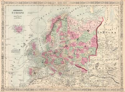
$15.00 Shipping Location: Brooklyn, United States An ORIGINAL antique 1864 map of EUROPE from JOHNSON'S New Illustrated FAMILY ATLAS. Countries and Provinces within countries are individually HAND ... moreWATERCOLORED. Very different from today. RUSSIA controls Finland, Poland, the Baltic, TURKEY controls the Balkans, and GERMANY is broken into a number of semi-independent States. A unique feature of this map is the exceptional detail of the RUSSIAN EMPIRE. Not just the European part but an equally large section of Asiatic Russia showing TARTARY, RUSSIAN TARTARY, and the Trans-Ural region drained by the River OB or OBI. There are a number of early explorer routes shown in the Atlantic and including Cook. Carteret, Byron, Wallis, Vancouver, and others. Among the finest maps produced during the 19th Century. Johnson's maps were used extensively during the Civil War. The map measures 26 by 18 inches and is perfect for matting and framing. This ORIGINAL antique map is guaranteed over 150 years old, published during the CIVIL WAR. I do not sell reproductions, just honest maps at honest prices. Discounted shipping too. NO international shipping. NO exceptions. All items shipped within 2 business days after payment. If you have not received an item in a reasonable amount of time please email me. It has been delayed by the Post Office. I also accept returns on ANY item for ANY reason, please email me I am very easy to work with. Feedback is not the same thing as an email, please email first. On Oct-19-07 at 13:06:06 PDT. Seller added the following information:
Buy It Now
$6.80 Shipping Location: Santa Barbara, United States 1866 Johnson's France, Spain & Portugal, Corsica, Gibraltar Rock, Ibiza, Majorca This is a colorful map from Johnson's Atlas showing great detail of France, ... moreSpain, and Portugal. Also shown are the Balearic Islands, an inset map of Corsica, and an inset map of Gibraltar Rock.

Buy It Now
$15.00 Shipping Location: Brooklyn, United States 1861 Johnson Map of England and Wales WE SELL ONLY ORIGINAL ANTIQUE MAPS- NOT REPRODUCTIONS Title: Johnson's England and Wales. Description: This ... moreis a beautiful example of A. J. Johnson and R. Browning's 1861 map of England and Wales. The map covers both England and Wales in full from Scotland south to the English Channel and The Channel Islands. And from St. George’s Channel to the mouth of the Thames River, including the Isle of Man. In the upper right hand quadrant there is a list of counties in England and Wales, respectively. The lower left hand quadrant features an inset of the Scilly Isles. During the middle part of the19th century, both England and Wales were in the midst of the Industrial Revolution wherein much of the rural agricultural population relocated to urban centers. The map is color coded according to regions and notes several towns, cities, rivers, and various other topographical details with relief shown by hachure. It features the strapwork style border common to Johnson’s atlas work from 1860 to 1863. Published by A. J. Johnson and Browning as plate nos. 65 and 66 in the 1861 edition of Johnson’s New Illustrated Family Atlas. This is the last edition of the Johnson Atlas to bear the'Johnson and Browning' imprint. Subsequent editions reflect Ward's 1862 acquisition Ross C. Browning's shares in the firm. Size: Printed area measures 26 inches high by 17.5 inches wide. Condition: Very good. Minor toning along original centerfold. Blank on verso. Minor foxing. Minor verso repair along margins. Shipping: Due to recent increases in United States Postal Service rates we have been forced to increase our shipping rates. Shipping rates are not negotiable. Items are shipped within three business days of receiving payment. We are happy to consolidate shipping where possible. The following shipping options are available: 1. USPS Domestic Express Mail(35 USD) USA Only. 2. USPS Priority Mail(15 USD) USA Only. 3. USPS International Express(35 to 55 USD) Recommended service for all in
Buy It Now
$6.23 Shipping Location: Half Moon Bay, United States Genuine Antique map"Johnson's Russia" from Johnson's Family Atlas of the World published by A. J. Johnson. New York, 1870. Bright hand ... morecolored map of Russia shows mountains, waterways and lakes in nice detail. Shorelines are nicely illustrated, and cities are named. This attractive image is surrounded by an elegant border. Very good condition with only slight age toning. Center fold as issued. Image measures 22 1/2" x 16 3/4" THIS IS NOT A REPRODUCTION! All of our items are genuine antiques as described. n6gonr.RcmdId ViewItemDescV4,RlogId p4%60bo7%60jtb9%3Fuk%601d72f%2B26rk%3En6gonr-13e984b1141-0xfd-

Buy It Now
$15.00 Shipping Location: Brooklyn, United States 1865 Johnson Map of Russia WE SELL ONLY ORIGINAL ANTIQUE MAPS- NOT REPRODUCTIONS Title: Johnson's Russia. Description: A beautiful example of Johnson ... moreand Ward’s 1865 map of Russia. Depicts the european portions of Russia from the Arctic Sea south to the Black Sea and Caspian Sea. extends west as far as Warsaw and east as far as Orenburg and Perm. Includes the Ukraine. Features the fretwork style border common to Johnson’s atlas work from 1864 to 1869. One of the more attractive American atlas maps of Russia to appear in the mid-19th century. Published by A. J. Johnson and Ward as plate number 92 in the 1865 edition of Johnson’s New Illustrated Family Atlas. This is the first edition of the Johnson Atlas to be attributed to Johnson exclusively. Size: Printed area measures 17 inches high by 14 inches wide. Condition: Very good. Text on verso. Minor overall toning and foxing. Creasing near left border. Shipping: Due to recent increases in United States Postal Service rates we have been forced to increase our shipping rates. Shipping rates are not negotiable. Items are shipped within three business days of receiving payment. We are happy to consolidate shipping where possible. The following shipping options are available: 1. USPS Domestic Express Mail(35 USD) USA Only. 2. USPS Priority Mail(15 USD) USA Only. 3. USPS International Express(35 to 55 USD) Recommended service for all international parcels. You will be invoiced at the lowest Express Mail rate possible. 4. USPS Priority Mail(35 USD) Available to only certain countries. Due to high instances of loss. This service is specifically NOT AVAILABLE to MAINLAND CHINA or INDIA. 5. Federal Express is available upon request. This is the only service option available to India and Africa. Price is quoted upon request following the auction. We can also use your Federal Express Account. Insurance: All shipments are insured privately against loss and damage. All of our shipments require a signature. If you have any questions please feel free to email us through e
Buy It Now
$11.92 Shipping Location: SHREWSBURY, United Kingdom A lithographed map of Surrey enhanced with original full wash hand colouring. Very scarce map. Published London 1863 in Johnson's Atlas of England. by ... moreThomas Johnson. 9" x 6.5" (230mm x 160mm) map area only with good margins beyond.
Buy It Now
$16.25 Shipping Location: BOURNE END, United Kingdom Antique Military Map The Battle of Vitoria 1814.
Buy It Now
$33.88 Shipping Condition: Unspecified Location: LONDON, United Kingdom 'Southern part of Ayrshire'. Title of map:'Southern part of Ayrshire'. Engraved by T. Clerk. Compiled from Estate Plans &c. by William Johnson, Land Surveyor, ... moreEdinburgh., printed for John Thomson & Co.
Buy It Now
$33.88 Shipping Condition: Unspecified Location: LONDON, United Kingdom Drawn by W Johnson. Engraved by W Dassauville. Lewis by Chapman; Harris by Ainslie; North Uist by Reid; Benbecula by Bald; South Uist & Eriskay by Bald; ... moreBarra by Maclean. 'Middle part of Western Isles.
Buy It Now
$23.78 Shipping Location: NORWICH, United Kingdom Original antique map by J Hugh Johnson. Published by A Fullarton, Edinburgh, London and Dublin. Ex The Royal Illustrated Atlas, Of Modern Geography. Undated, ... morebut c1872. Map size 59 x 48cm inclusive of the border (52.5 x 41cm to the inner margin).
Buy It Now
$6.80 Shipping Location: Santa Barbara, United States 1866 Johnson's England and Wales, London, Scotland, English Channel This is a colorful map from Johnson's Atlas showing great detail of England and Wales. ... moreJohnson's England and Wales by A.J. Johnson, New York.
Buy It Now
$10.04 Shipping Condition: Unspecified Location: LONDON, United Kingdom Compiled by William Johnson, Land Surveyor, Edinburgh., printed for John Thomson & Co. Edinburgh; Baldwin & Cradock, London; and John Cumming, Dublin. ... moreAntique early 19th century atlas map with original hand colouring, 1832.
Buy It Now
$15.00 Shipping Location: Brooklyn, United States 1862 RARE JOHNSON'S BEAUTIFUL ANTIQUE ATLAS MAP OF AUSTRALIA-HANDCOLORED-BORDER, Click to View Image Album 1862 RARE JOHNSON'S BEAUTIFUL ANTIQUE ... moreATLAS MAP OF AUSTRALIA-HANDCOLORED-BORDER BEAUTIFUL DETAILED JOHNSON'S ATLAS MAP PLEASE SEE PHOTOS AS PART OF THE DESCRIPTION CONDITION: MAP IS IN GOOD CONDITION WITH NICE BORDER- SOME SMALL EDGE TEARS SIZE: APPROXIMATELY 14" X 17" SHIPPING: U.S. FIRST CLASS RATE- $4.00. CANADA- $7.00. WORLDWIDE- $14.00 THANK YOU FOR YOUR INTEREST IN OUR AUCTIONS Payment I accept the following forms of payment: PayPal Shipping& Handling $5.00 USPS First-Class Mail® FREE scheduling. Supersized images and templates. Get Vendio Sales Manager. FREE scheduling. Supersized images and templates. Get Vendio Sales Manager. Over 100.000,000 served. Get FREE counters from Vendio today!
Buy It Now
Free Shipping Location: San Diego, United States An ex-atlas map published by Johnson and Ward in New York City, from Johnson’s New General Atlas. Hand colored map of England and Wales, colored by counties, ... morein vibrant colors, with red outline color denoting the border.
Buy It Now
$9.99 Shipping Location: Prairieville, United States A beautiful map of Spain & Portugal as it was in 1862, with an inset of Gibraltar. AUTHENTIC ORIGINAL ANTIQUE 1862 JOHNSON'S MAP of SPAIN & PORTUGAL. ... moreMap is sourced from Johnson's New Illustrated Family Atlas, Published 1862.
Buy It Now
$9.00 Shipping Location: Cincinnati, United States Title:Colton's Germany No.2. Colton’s General Atlas. Date: 1860. The title page is for your identification propose only and not included with the map. ... moreThis beautiful and originally hand colored map of Germany [plate No.13 ] was from.
Buy It Now
$10.04 Shipping Condition: Unspecified Location: LONDON, United Kingdom 'Kincardineshire // North East view of Dunnotar Castle'. Title of map:'Kincardineshire // North East view of Dunnotar Castle'. Drawn by W Johnson. Engraved ... moreby Hewitt., printed for John Thomson & Co.
Buy It Now
$6.80 Shipping Location: Eagle, United States Presented is an authentic, old map taken from Johnson's Family Atlas published in 1864. Original hand color. Condition reflects lower price.
Buy It Now
$6.80 Shipping Location: Eagle, United States Presented is an authentic, old map taken from Johnson's Family Atlas published in 1864. Original hand color. Condition reflects lower price.
Buy It Now
$16.45 Shipping Location: Wakefield, United States This map is from Johnson's New Family Atlas. Published by Johnson& Ward in 1864. This antique authentic map shows Johnson's WEST INDIES by ... moreJohnson& Ward The map was printed on newsprint paper which has yellowed and has some areas of discoloration and age staining. Which can be viewed in the photographs. There are also small tears at some edges. Please note in particular some water staining on the edges(pictured) It measures just over 18 inches by about 26 inches. However. It's a wonderful old piece, and would be great framed, for a collector of antique maps. I am selling all of the maps from the Atlas. In separate auctions. I would be very happy to save on shipping costs by combining items. Please email with questions.
Buy It Now
$6.52 Shipping Location: MARLOW, United Kingdom Both are rare and only known in a handful of copies. PROVENANCE: Published in the very rare Johnson's Atlas of England with all the Railways. VERSO : ... moreThere is nothing printed on the reverse side, which is blank.

Buy It Now
$15.00 Shipping Location: Brooklyn, United States 1865 Johnson Map of Holland and Belgium WE SELL ONLY ORIGINAL ANTIQUE MAPS- NOT REPRODUCTIONS Title: Johnson's Holland and Belgium. Description: This ... moreis a beautiful example of Johnson and Ward’s 1865 map of Holland(the Netherlands) and Belgium. It covers both Holland and Belgium from Friesland to Luxembourg. Inset city plans in the upper left quadrant detail Amsterdam and Brussels. In 1830. The Belgian Revolution led to the secession of Belgium from the United Kingdom of Netherlands and it's subsequently consolidation as the independent Kingdom of Belgium. Though Belgium had successfully attained self-rule, the Netherlands refused to recognize the new country until the 1839 Treaty of London. Various towns, cities, railways, rivers and several other topographical features are noted with relief shown by hachure. It features the fretwork style border common to Johnson’s atlas work from 1864 to 1869. Published by A. J. Johnson and Ward as plate no. 84 in the 1865 edition of Johnson’s New Illustrated Family Atlas. This is the first edition of the Johnson Atlas to be attributed to Johnson exclusively. Size: Printed area measures 16.5 inches high by 13 inches wide. Condition: Very good. Text on verso. Minor overall toning and foxing. Shipping: Due to recent increases in United States Postal Service rates we have been forced to increase our shipping rates. Shipping rates are not negotiable. Items are shipped within three business days of receiving payment. We are happy to consolidate shipping where possible. The following shipping options are available: 1. USPS Domestic Express Mail(35 USD) USA Only. 2. USPS Priority Mail(15 USD) USA Only. 3. USPS International Express(35 to 55 USD) Recommended service for all international parcels. You will be invoiced at the lowest Express Mail rate possible. 4. USPS Priority Mail(35 USD) Available to only certain countries. Due to high instances of loss. This service is specifically NOT AVAILABLE to MAINLAND CHINA or INDIA. 5. Federal Express is available upon request. This
Buy It Now
Free Shipping Location: Monroeville, United States Size - about 18x26”, hand-colored, double page, unrelated tables or text on reverse. Date - 1864. Source - Johnson’s New Illustrated Family Atlas of the ... moreWorld. Publisher - Johnson and Ward.

Buy It Now
$15.00 Shipping Location: Brooklyn, United States 1864 Johnson Map of Australia WE SELL ONLY ORIGINAL ANTIQUE MAPS- NOT REPRODUCTIONS Title: Johnson's Australia. Description: This is Johnson and Ward's ... more1864 map of Australia. The map covers the entire continent including Tasmania or Van Diemen's Land. Johnson's mappings of Australia. Updated annually through the 1860s, offer a comprehensive overview of the exploration of the continent's interior. This example depicts the continent with good detail along the coast and a largely unexplored interior. Shows the Torrens Basin, the Stony Desert, Traveler's Valley, and the extant of Sturt's inland exploration. Tables in the corners show references to various counties in each province. A smaller table in the lower left provides a time line for the exploration of the continent, noting the dates associated with important navigators including Tasman, Arnhem, Hartog, Edel, Flinders, and others. Various towns, cities, rivers and several other topographical features are noted with relief shown by hachure. It features the fretwork style border common to Johnson’s atlas work from 1863 to 1869. Steel plate engraving prepared by A. J. Johnson for publication as plate no. 98 in the 1864 edition of his New Illustrated Atlas. This is the first edition of the Johnson’s Atlas to bear the Johnson& Ward imprint and the only edition to identify the firm as the'Successors to Johnson and Browning(Successors to J. H. Colton and Company) Size: Printed area measures 14 inches high by 16.5 inches wide. Condition: Very good. Text on verso. Minor overall toning. Shipping: Due to recent increases in United States Postal Service rates we have been forced to increase our shipping rates. Shipping rates are not negotiable. Items are shipped within three business days of receiving payment. We are happy to consolidate shipping where possible. The following shipping options are available: 1. USPS Domestic Express Mail(35 USD) USA Only. 2. USPS Priority Mail(15 USD) USA Only. 3. USPS International Express(35 to 55 USD)
Buy It Now
$4.15 Shipping Location: Saco, United States Up for Sale is a Beautiful 1864 Colored Map featuring AFRICA. A. J. Johnson's Family Atlas. The Outer Edge or the Map will have Browning, Smudges and/or ... moreStains. Any and all other blemishes will be shown in photos.
Buy It Now
$4.15 Shipping Location: Saco, United States Up for Sale is a Beautiful Colored Map featuring France, Spain and Portugal.This Single Sheet Double Page Atlas Map was Extracted by Myself from an 1867 ... moreA. J. Johnson's Family Atlas. The Outer Edge or the Map will have Browning, Smudges and/or Stains.
Buy It Now
$6.80 Shipping Location: Eagle, United States Presented is an authentic 150+ year old map taken from a dis-bound atlas published by Johnson & Browning in New York in 1862. All color is original and ... morewas hand done. A few have small margin tears.

Buy It Now
$15.00 Shipping Location: Brooklyn, United States 1868 Johnson Map of England and Wales WE SELL ONLY ORIGINAL ANTIQUE MAPS- NOT REPRODUCTIONS Title: Johnson's England and Wales. Description: This ... moreis A. J. Johnson's 1868 map of England and Wales. The map covers both England and Wales in considerable detail with color coding at the county level. Major roadways. Cities, rivers, trains and ferry crossings are identified. In the lower left hand quadrant there is an inset of the Scilly Isles. Features the fretwork style border common to Johnson's atlas work from 1864 to 1869. Based on a similar 1855 map by J. H. Colton. Steel plate engraving prepared by A. J. Johnson for publication as page nos. 76-77 in the 1868 edition of his New Illustrated Atlas. Size: Printed area measures 26 inches high by 18 inches wide. Condition: Very good. Verso repairs at margin and on original centerfold. Text on verso. Shipping: Due to recent increases in United States Postal Service rates we have been forced to increase our shipping rates. Shipping rates are not negotiable. Items are shipped within three business days of receiving payment. We are happy to consolidate shipping where possible. The following shipping options are available: 1. USPS Domestic Express Mail(35 USD) USA Only. 2. USPS Priority Mail(15 USD) USA Only. 3. USPS International Express(35 to 55 USD) Recommended service for all international parcels. You will be invoiced at the lowest Express Mail rate possible. 4. USPS Priority Mail(35 USD) Available to only certain countries. Due to high instances of loss. This service is specifically NOT AVAILABLE to MAINLAND CHINA or INDIA. 5. Federal Express is available upon request. This is the only service option available to India and Africa. Price is quoted upon request following the auction. We can also use your Federal Express Account. Insurance: All shipments are insured privately against loss and damage. All of our shipments require a signature. If you have any questions please feel free to email us through eBay or contact us by telephone at 646-320-8650. Additio
Buy It Now
$4.15 Shipping Location: Saco, United States Up for Sale is a Beautiful Colored Map of China with Colored Provinces.This Single Sheet Atlas Map was Extracted by Myself from an 1867 A. J. Johnson's ... moreFamily Atlas. The Outer Edge or the Map will have Browning, Smudges and/or Stains.
Buy It Now
$6.80 Shipping Location: Eagle, United States Presented is an authentic, old map taken from Johnson's Family Atlas published in 1864. Original hand color. Condition reflects lower price.
|
|
|
|