|
|
Order by: Available to: This site contains affiliate links for which I may be compensated
|
Buy It Now
Free Shipping Location: Monroeville, United States Beautiful antique MAP on quality paper very good condition and rescued from a disbound Atlas 1898: The World Wide Atlas W& A K Johnston THIS MAP IS ... moreAN ORIGINAL- APPROXIMATLELY 120 YEARS OLD AND NOT A REPRODUCTION This single page measures approximately 11 1/2 inches by 9 inches(293mm x 292mm) Printed on quality paper The map will have another image on the reverse ~ HAND COLOURED COUNTRY/COUNTY BORDERS ~ FREE FROM ANY FOLDS. CREASES OR TEARS A superb map in very good condition PLEASE VIEW IMAGE FOR ANY MINOR HANDLING/AGE MARKS AT EXTREMITIES Please email with any questions regarding this item(World Wide Atlas WR 1898) BEST OFFERS PLEASE FOR A QUICK SALE AT A FAIR PRICE If you like the item. But do not like the price, then make a realistic offer to us using the MAKE OFFER BUTTON Powered by
Buy It Now
$5.00 Shipping Location: Canada DATE OF ISSUE: 1911. ORIGIN OF THE MAP:"The Rhine", 17th edition,published in Leipzig, Germany by Karl Baedeker.
Buy It Now
$6.90 Shipping Location: Audubon, United States It is an old, original map that was rescued from an unusable atlas. You will receive the exact antique map in the photos.
Buy It Now
$78.58 Shipping Location: Cedar Rapids, United States Created in 1964, it is printed on laminated canvas using high-quality printing techniques and is in excellent condition for its age. Side 1 Map 13, Bassin ... moreAquitain et Pyrenees. Side 2 Map 14, Alpes-Jura.
Buy It Now
$5.00 Shipping Location: Canada DATE OF ISSUE: 1911. ORIGIN OF THE MAP:"The Rhine", 17th edition,published in Leipzig, Germany by Karl Baedeker.
Buy It Now
$6.95 Shipping Location: Dover, United States Venezia Giulia.
Buy It Now
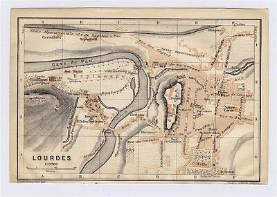
$5.00 Shipping Location: Canada 1914 ORIGINAL ANTIQUE CITY MAP OF LOURDES/ MIDI-PYRENEES/ FRANCE This original antique map gives you an opportunity to examine in exquisite detail a piece ... moreof history. Once matted and framed. This map would make a perfect gift for a family member or friend they'll cherish forever. Origin of the map: Southern France including Corsica- Handbook for Travellers" 6th edition, published by Karl Baedeker in Leipzig, Germany, Dulau& Co. London, UK, Charles Scribner's Sons, New York, USA. Date of issue: 1914 Size: The sheet measures: 6" x 4" 15.5 x 10 cm) S/H: The map will be shipped by Air Mail. The shipping charge is: USA- 4.00 USD. World- 6.00 USD, Canada- 1.80 USD. The price includes a strong and secure envelope. Attention! We combine shipping costs for multiple items. The HIGHEST VALUE SHIPPING FEE WILL APPLY FIRST and each subsequent item will be shipped FOR FREE. Pay me securely with any major credit card through PayPal! Payment methods: US/Canada Buyers: Paypal. International Buyers: Paypal. Click Here. Double your traffic. Get Vendio Gallery- Now FREE! USED. AN ORIGINAL ANTIQUE MAP.
Buy It Now
$6.95 Shipping Location: Dover, United States Charming small mid 19th century map with original outline hand color.
Buy It Now
$12.00 Shipping Location: United States This is a vintage Berann (Germany) map Italy - School wall large 55x43". Light on map is just reflection of light. Ships fast!
Buy It Now
$16.81 Shipping Location: OAKHAM, United Kingdom Explore Ipswich of the 1920s with this vintage Ordnance Survey Map. Made of high-quality cloth panels, this antique original features intricate details ... moreof the city and its surroundings. Perfect for collectors or as a unique piece of decor, this folding map is a must-have for anyone interested in the history of Ipswich and the United Kingdom. With a date range of 1920-1929, this map captures the era and spirit of the vibrant city. Add it to your collection today and own a piece of history!
Buy It Now
$13.80 Shipping Location: MANCHESTER, United Kingdom He based his atlases on the plates used by Edward Weller for his Weekly Dispatch Atlas. This map is from Bacon's Popular Atlas of The World by G.W. Bacon ... more& Co., London, 1902. This interesting map is an original antique which is over 120 years old.
Buy It Now
Free Shipping Location: Israel Image size: 21.5 cm x 26.5 cm. We should be patient, together.
Buy It Now
$5.00 Shipping Location: Canada DATE OF ISSUE: 1887. ORIGIN OF THE MAP: J. Trousset, "Nouveau dictionnaire encyclopédique - Vol.
Buy It Now
$6.90 Shipping Location: Jasper, United States Known for being one of the oldest and most respected publishing houses in Germany, the Bibliographisches Institut specialized in authoritative reference ... moreworks. I believe they deserve to be appreciated by fellow collectors rather than gathering dust in storage.
Buy It Now
$6.95 Shipping Location: Dover, United States Issued 1842, Mila by Ferd. Artaeia e Figlio. Engraved by Allodi. Scarce mid 19th century Italian engraved city plan with attractive hand color. Numbered ... morekey identifies 17 locations.
Buy It Now
$6.95 Shipping Location: Dover, United States Issued c. 1863, Paris by Le Chevalier. Map by Dufour and Dyonnet. Oversized large folio sheet mid 19th century engraved map with original hand color. ... moreOriginal center fold as issued.
Buy It Now
$7.84 Shipping Location: BECCLES, United Kingdom VINTAGE SEA CHART / NAUTICAL MAP 1961 - To Frame?. Measures approx 30cm x 20cm This is taken from a nautical book of 1961, an interesting item which would ... morelook good framed perhaps?
Buy It Now
$3.00 Shipping Location: United States Fine antique 1854 handcolored map, titled Germany. Austria is shown as part of Germany. Attractive and interesting period map of these areas. Printed ... moreon fine thick paper, no printing on reverse. The size of the map is 5.25" by 7".
Buy It Now
$13.80 Shipping Location: MANCHESTER, United Kingdom This large folding map is from The Weekly Dispatch published in London in 1861.
Buy It Now
$6.95 Shipping Location: Dover, United States Various pie charts add to the detail. Foreign Trade of Russia by Commodities for 1913 & 1922 [insets at bottom]. Issued 1925-8, London by the London Geographical ... moreInstitute, printed by George Philip & Son.
Buy It Now
$4.99 Shipping Location: Fairview, United States A copy of the Atlas title page is included for authenticity. It is blank on the reverse with a centerfold as issued. Condition: It is in Very Good to ... moreExcellent condition for its age with only very light overall tonal ageing and a centerfold as issued, basically as seen in the pics.
Buy It Now
$10.75 Shipping Location: Omaha, United States Very old map of Sarreguemines, France. Map is in 8 parts carefully re-constructed and glued to a white fabric to preserve it. It may have torn at the ... morefold lines but it has been painstakingly repaired.
Buy It Now
$33.54 Shipping Location: Canada OFFERED HERE WE HAVE AN ANTIQUE MAP FROM CAMDENS BRITANNIA 1695(SURREY)ROBERT MORDEN GENUINE ORIGINAL(I KNOW THIS AS I HAVE THE BOOK ALL THE MAPS WHERE ... moreIN)AS PICTURED 318 YEARS OLD!GUARANTEED OR YOUR MONEY BACK,LISTING MOST OF THE MAPS FROM THE 1695 CAMDENS BRITANNIA.IM LISTING OVER 40 OF THESE MAPS AND WILL POST AS MANY AS YOU WIN FOR THE SAME PRICE,OFFERED HERE WITH A FAIR STARTING PRICE OR USE THE BUY IT NOW
Buy It Now
$5.00 Shipping Location: Canada DATE OF ISSUE: 1914. ORIGIN OF THE MAP: "Southern France including Corsica - Handbook for Travellers", 6th edition, published by Karl Baedeker in Leipzig, ... moreGermany, Dulau & Co., London, UK, Charles Scribner's Sons, New York, USA.
Buy It Now
$5.70 Shipping Location: Sheboygan Falls, United States NEW MAP OF EUROPE LATEST BOUNDARIES and Occupation Zones The only date I've found is a stamped date of Jan 3. There is no year. This map does have pieces ... moreof tape on the edges & frayed edges.
Buy It Now
$5.00 Shipping Location: Canada DATE OF ISSUE: 1911. ORIGIN OF THE MAP: "Switzerland", 24th edition, published in Leipzig, Germany by Karl Baedeker, London, T. Fisher Unwin and New York, ... moreCharles Scribner's Sons.

Buy It Now
$6.90 Shipping Location: Springfield, United States Europe Roman Empire 1838 antique map w/ old color Monin& Fremin EMPIRE ROMAIN Issued Paris: c. 1836-8; by Monin& Femin. Fine original antique ... moreengraved map. Made approximately 175 years ago. Printed in the mid-19th century in France, on quality paper which retains its inherent structural flexibility and soundness. With original outline hand color. In near VG or better condition. Light minor surface dusting, overall clean[note: we grade very conservatively and always seek to disclose any noteworthy flaws] The printed area remains visually pleasing, a nice impression of an interesting image. Any defects along the sheet edges and in the margins may be seen in the photos. Sheet measures c. 12 1/4" W x 9 1/2" H. Engraved area measures c. 9 5/8" W x 7 1/2" H. 12404] note: All old sheets of printed paper possibly have short edge splits. Each sheet has existed for a very long time and has probably been handled repeatedly in the course of it's existence. It has a history unique to it as an object. Most of the time any edge splits are short. Minor, insignificant and have been closed- either long ago or more recently with small pieces of archival tape. Most often these splits are trivial and easy to overlook visually. Basically, they would not significantly affect the piece adversely. The item is offered as seen. Please look carefully and make your decision knowing this antique image is nice. But it is not in perfect"like new" condition. However, with whatever flaws it possesses, it remains entirely worthy of ownership and inclusion in any related collection. We feel it will prove very pleasing to its new owner. We stand behind everything we sell. Everything we offer is guaranteed to be an authentic original antique item as described. We do not sell modern reproductions. Please visit our eBay Store. We happily accept PayPal! WE OFFER FLAT RATE SHIPPING WORLD WIDE! Please request an invoice before paying for multipl
Buy It Now
$8.78 Shipping Location: LLANFAIRFECHAN, United Kingdom Ordnance Survey Irish District Map Ordnance Survey one-inch map of Ireland. Killarney District. Published in 1947, with railways revised to 1946, and ... moreroad classification as of 1942. Printed on paper. And folded in the original covers. The map is in good condition(some light wear to the folds) Covers: Killarney. Kenmare, Kilgarvan, Glengarriff. Have a look at my other auctions: I am selling some similar maps. I am always happy to combine postage for multiple purchases.
Buy It Now
$8.80 Shipping Location: Monroeville, United States Date - 1887. Size - about 10x12", unrelated text on reverse. Condition - Fine. Good Luck!
Buy It Now
$3.50 Shipping Location: Winter Springs, United States The superb handcoloring is period to the map, this is before color printing. The size of the map is 9.25" by 11". FREE scheduling, supersized images.
Buy It Now
$5.00 Shipping Location: Canada DATE OF ISSUE: 1911. ORIGIN OF THE MAP: "Switzerland", 24th edition, published in Leipzig, Germany by Karl Baedeker, London, T. Fisher Unwin and New York, ... moreCharles Scribner's Sons.
Buy It Now
$3.50 Shipping Location: Winter Springs, United States Superb, antique 1885 color lithographed map, very finely produced. Also an attractive detailed period map. The size of the map is 11.5" by 13.5". FREE ... morescheduling, supersized images.
Buy It Now
$7.84 Shipping Location: BECCLES, United Kingdom VINTAGE SEA CHART / NAUTICAL MAP 1961 - To Frame?. Measures approx 30cm x 20cm This is taken from a nautical book of 1961, an interesting item which would ... morelook good framed perhaps?
Buy It Now
$5.00 Shipping Location: Canada ORIGIN OF THE MAP: "Northern France (.) - Handbook for Travellers", 5th edition (1919 reprint of the 1909 edition), published by Karl Baedeker in Leipzig, ... moreGermany, Dulau & Co., London, UK, Charles Scribner's Sons, New York, USA.
6d 18h 55m 59s 0 bids
$9.00 Now
$8.60 Shipping Location: Tampa, United States
Buy It Now
$2.65 Shipping Location: Winter Springs, United States Very nicely engraved, attractive and detailed period map. The map is printed on fine period handmade paper, no printing on reverse. The size of the map ... moreis 3.75" by 6". FREE scheduling, supersized images.
Buy It Now
$4.93 Shipping Location: Kassel, Germany Netherlands and Belgium Original map from 1885 (no reprint - no copy) The well-preserved lithographic map on a scale of 1: 1,750,000 comes from the FABrockhaus ... moreGeogr. - artist. Institution in Leipzig and was ranked 13th for the Brockhaus conversation lexicon. Edition made. Sheet size approx. 29 x 23.5 cm, folded in the middle. Condition: slightly browned due to age, otherwise good - see scan Shipping is of course quick and packaged to be kink-proof! Please also note my other auctions! I offer many more old maps and city maps - use the shop search. Shipping costs only apply once for multiple items purchased! Motifs: Holland, Belgium,.
$18.68 Shipping Location: WIGAN, United Kingdom Date and Edition: - details to follow. Up to 1kg will be £3.95, up to 2kg £4.50, up to 5Kg £7.85, up to 10Kg £9.50, up to 15Kg £13.50.
$18.68 Shipping Location: WIGAN, United Kingdom Date and Edition: - details to follow. Up to 1kg will be £3.95, up to 2kg £4.50, up to 5Kg £7.85, up to 10Kg £9.50, up to 15Kg £13.50.
Buy It Now
$5.00 Shipping Location: Canada DATE OF ISSUE: 1911. ORIGIN OF THE MAP: "Switzerland", 24th edition, published in Leipzig, Germany by Karl Baedeker, London, T. Fisher Unwin and New York, ... moreCharles Scribner's Sons.
Buy It Now
$6.27 Shipping Location: United Kingdom Ministry of the Interior 1912 printing. Excellent condition, see scans. Size folded: 22cm x 14cm approx.
Buy It Now
$5.00 Shipping Location: Canada DATE OF ISSUE: 1904. ORIGIN OF THE MAP: "Northern Germany", 14th edition, published in Leipzig, Germany by Karl Baedeker, London by T. Fisher Unwin and ... moreNew York by Charles Scribner's Sons.
Buy It Now
$5.00 Shipping Location: Canada DATE OF ISSUE: 1913. ORIGIN OF THE MAP: "Northern Italy - Handbook for Travellers", 14th edition, published by Karl Baedeker in Leipzig, Germany, in London, ... moreUK by T. Fisher Unwin, and New York, USA by Charles Scribner's Sons.
Buy It Now
$5.00 Shipping Location: Canada DATE OF ISSUE: 1887. ORIGIN OF THE MAP: J. Trousset, "Nouveau dictionnaire encyclopédique - Vol.
Buy It Now
$5.00 Shipping Location: Canada DATE OF ISSUE: 1911. ORIGIN OF THE MAP: "Nordwest-Deutschland", 30th edition,published in Leipzig, Germany by Karl Baedeker.
Buy It Now
$6.00 Shipping Location: North Wales, United States 1914 RARE ANTIQUE BAEDEKER ATLAS MAP-STATTGART, GERMANY-EXCELLENT DETAIL ORIGINAL ANTIQUE ATLAS MAP PLEASE SEE PHOTOS AS PART OF THE DESCRIPTION CONDITION: ... moreMAP IS IN GOOD CONDITION. SIZE: APPROXIMATELY 6" X 6" SHIPPING: U.S. FIRST CLASS RATE - $6.00 - ANY ITEM WHICH SELLS FOR OVER $100 WILL REQUIRE INSURANCE WE COMBINE SHIPPING FOR MULTIPLE WINS. THANK YOU FOR YOUR INTEREST IN OUR AUCTIONS!.
Buy It Now
$6.95 Shipping Location: Dover, United States Charming small mid 19th century map with original outline hand color. Despite the relatively small size nicely engraved with a remarkable level of tiny ... moredetail. Dictionary of Mapmakers, vol.
Buy It Now
Free Shipping Location: Orlando, United States
Buy It Now
$7.84 Shipping Location: BECCLES, United Kingdom VINTAGE SEA CHART / NAUTICAL MAP 1961 - To Frame?. Measures approx 30cm x 20cm This is taken from a nautical book of 1961, an interesting item which would ... morelook good framed perhaps?

Buy It Now
$4.99 Shipping Location: Fairview, United States Lake Erie Maps& Prints An Authentic Antique Map: Not a Modern Reproduction! Free Shipping on Purchases of 5 or More Maps or Prints See our Gallery ... moreBelow and Store Listings for more Great Antique Maps! Description: It is an authentic engraved antique map approximately 165 years old with original handcolor outlining. It is from Houze's Atlas Universel Historique et Geographique(Paris: Dumenil. 1841) A copy of the Atlas title page with date is included for authenticity. The name of A. Houze appears in the title block, under whose directions the maps were designed and engraved. It is being sold as a single sheet, not mounted, matted nor framed, basically as seen in the pic, photographed against a dark background so you can see all the edges and actual condition. The map was actually printed in 1841, but depicts an earlier historical period, prepared by Houze, a member of the Societe de Geographie in Paris. A great map for anyone interested in this historical period. Overall a very nice example printed on strong paper with original handcolor in great shape. Size: The map image measures approximately 8 by 11(20x28cm) inches on a 10 by 13" 26x33cm) page with a margin all around for matting. As seen in the main pic. Condition: It is in Very Good to Excellent condition for its age with light tonal ageing. They have been numbered in India Ink in the corner. Other than some very minor darkening around the edges. It is very clean with a nice overall antique appearance and superb color that would frame up nicely. It is printed on heavy paper with original hand coloring, blank on the reverse. See the pic of the actual map for a better idea of the actual condition. Payment Details: We accept most major credit cards through Paypal and Ebay. Please ask if you have any questions about payment. International and New Bidders are welcomed and encouraged. Payment is expected within 7 days. After which Nonpaying Bidders will be reported to Ebay to recoup our listing fees. Shipping: $2.90 for First Class or $4.95 for Priori

Buy It Now
$5.00 Shipping Location: Canada 1910 ANTIQUE CITY MAP OF LEEUWARDEN/ HOLLAND NETHERLANDS This original antique map gives you an opportunity to examine in exquisite detail a piece of ... morehistory. Once matted and framed. This map would make a perfect gift for a family member or friend they'll cherish forever. Origin of the map: Belgium and Holland" 15th edition, published in Leipzig, Germany by Karl Baedeker, London, T. Fisher Unwin and New York, Charles Scribner's Sons. Date of issue: 1910 Size: The sheet measures: 6" x 4" 15 x 10 cm) S/H: The map will be shipped by Air Mail. The shipping charge is: USA- 2.00 USD. World- 4.00 USD, Canada- 1.00 USD. The price includes a strong and secure envelope. Attention! We combine shipping costs for multiple items. The HIGHEST VALUE SHIPPING FEE WILL APPLY FIRST and each subsequent item will be shipped FOR FREE. Pay me securely with any major credit card through PayPal! Payment methods: US/Canada Buyers: Paypal. International Buyers: Paypal. Click Here. Double your traffic. Get Vendio Gallery- Now FREE!
Buy It Now
$3.50 Shipping Location: Winter Springs, United States Map is dated 1910 at bottom, this dates the map nicely. Reverse is Netherlands and Belgium, also with detailed chart, corresponding to the map itself. ... moreBeautiful period lithography. The size of the map is 10" by 13".
Buy It Now
$5.00 Shipping Location: Canada DATE OF ISSUE: 1905. ORIGIN OF THE MAP: "Northern France (.) - Handbook for Travellers", 4th edition, published by Karl Baedeker in Leipzig, Germany, ... moreDulau & Co., London, UK, Charles Scribner's Sons, New York, USA.
$17.27 Shipping Location: COLWYN BAY, United Kingdom Antique Ordnance Survey Map of Liverpool Coloured edition 1 Inch to 1 Mile 1913. pre-owned original antique map. Linen backed sectional paper folding ... moremap. map surface in very good clean condition. Some marginal marks / foxing. some cloth back tanning / marks. Cover wear.
Buy It Now
$4.99 Shipping Location: Fairview, United States It is from the. An Authentic Antique Map: Not a Modern Reproduction!
Buy It Now
$3.50 Shipping Location: Winter Springs, United States The superb handcoloring is period to the map, this is before color printing. The size of the map is 9.25" by 11". FREE scheduling, supersized images.
Buy It Now
$3.65 Shipping Location: United States Beautiful map. Fine color lithography. There is text on reverse, but you cant see it looking at the image as the paper is too thick. The size of the map ... moreis 11.5" by 14". FREE scheduling, supersized images.
Buy It Now
$5.00 Shipping Location: Canada DATE OF ISSUE: 1910. ORIGIN OF THE MAP:"Northern Germany", 15th edition,published in Leipzig, Germany by Karl Baedeker, London, T. Fisher Unwin and New ... moreYork, Charles Scribner's Sons.
Buy It Now
$6.95 Shipping Location: Dover, United States Issued 1806, Paris. Early 19th century antique engraved map with original hand color.
Buy It Now
$6.95 Shipping Location: Dover, United States Issued 1673, Vienna by Gualdo Priorato. Fine late 17th century engraved folio map of this town. Beautiful hand color. Clean and well preserved overall, ... morestill an entirely pleasing example of this 17th century city plan.
|
|
|
|
Europe Moscovy Poland Germany Persia Italy 1766 antique engraved hand color map
Europe Moscovy Poland Germany Persia Italy 1766 antique engraved hand color map Europe Issued 1766. London by Jefferys Fine original antique engraved map. Printed on quality paper which retains its inherent structural flexibility and soundness. With beautiful hand color. In near VG or better condition. Some light minor age wear and some slight staining but the image remains, clean, presentable and very attractive[note: we grade very conservatively and always seek to disclose any noteworthy flaws] The printed area remains visually pleasing. A nice impression of an interesting antique map. Any minor defects along the sheet edges and in the margins may be seen in the photos. Sheet measures c. 10 1/8" W x 7 7/8" H. Engraved area measures c. 8 3/4" W x 7" H. Original fold lines as issued. 39170] note: All old sheets of printed ... morepaper possibly have short edge splits. Each sheet has existed for a very long time and has probably been handled repeatedly in the course of it's existence. It has a history unique to it as an object. Most of the time any edge splits are short. Minor, insignificant and have been closed- either long ago or more recently with small pieces of archival tape. Most often these splits are trivial and easy to overlook visually. Basically, they would not significantly affect the piece adversely. The item is offered as seen. Please look carefully and make your decision knowing this antique image is nice. But it is not in perfect"like new" condition. However, with whatever flaws it possesses, it remains entirely worthy of ownership and inclusion in any related collection. We feel it will prove very pleasing to its new owner. We stand behind everything we sell. Everything we offer is guaranteed to be an authentic original antique item as described. We do not sell modern reproductions. Please visit our eBay Store. We happily accept PayPal! WE OFFER FLAT RATE SHIPPING WORLD WIDE! Please request an invo
|
|
|
RUSSIA BALTIC POLAND ST PETERSBURG EUROPE 1870 DUFOUR VERY LARGE ANTIQUE MAP
Title: RUSSIE OCCIDENTALE' Author: Dufour. Auguste-Henri( 1798- 1865) Engraver: Dyonnet. Charles(1822- 1880) Source: Grand atlas Universel physique. Historique et politique geographie ancienne et moderne' Date: 1870ca. Paris. Technique: Steel Engraving. Paper size: 82.5x60 cm. Condition: Dark impression on good paper. Original watercolor. No noticeable imperfections on engraved area. Some tears on margins. Very good conditions. Conditions are as you can see in the images. All of the engravings and books I sell are original. I guarantee all of my engravings to be authentic. Please examine the images provided carefully. And if you have any questions, please ask and I will be happy to help. Any item purchased from me may be returned for any reason for a full refund. If you buy more than one item. You have to pay only one shipping cost.
|
|
|
Vintage 1963 Caltex Europe map - good condition - Texaco brand
This listing is for a very nice Caltex Tour Planning Map of Europe. Issued in 1963. It is in quite good condition with only slight wear- nothing major at all. Creases are still crisp and I see no markings on the map. Caltex is the same as California Texas Oil Company. If you looked up this listing. You already know that! Included countries: Portugal. France, Spain, Switzerland, Austria, East Germany, West Germany, Luxembourg, Belgium, Great Britain(England, Scotland, Wales, Northern Ireland) Ireland/Eire, Norway, Sweden, Finland, Poland, Czechoslovakia, Italy, Yugoslavia, Hungary, Poland, USSR, Denmark. There is also a special map of Scandinavia on the back. Please check out my other auctions which include vintage travel brochures. Oil company maps, old post cards, and more! I am happy to combine shipping. And will ship internationally to ... moremost countries for an additional cost. My standard shipping method is US Mail with sturdy backing to help against being bent. Larger items(such as maps) are a Flat Rate Priority Envelope.
|
|
|
1945 ~ Map of 29th INFANTRY DIVISION in EUROPE ~ Signed by Soldiers 20x22
This auction is for a map that traces the movements and history of the Army's 29th Infantry Division from June 6. 1944- Jan. 1, 1945. This map belonged to my husband's uncle, who served with this Infantry Division during WWII. Measures approx. 20 x 22 inches. Along the bottom are signatures of 15 of the men who served with him. Map has light soiling, wear along the edges and at the folds and light creasing. Also some writing on the back. An interesting piece of history! Postage: $3.00 Terms: I only accept payments with Paypal. I will send you an invoice at the end of the auction or use Ebay checkout if you wish. Payment is due within 3 days after the auction ends. If you need more time or are bidding on multiple items. Please let me know.
|
|
|
War In Europe Map-Color-1944-WWII
This is a 20"x26" color map of War In Europe showing dated events up to 1944-6th edition. It is a folded map and is in good plus condition. It will be shipped folded not frame. Great historical item.
|
|
|
Russia Lapland Europe c1760 Map By Jefferys Decorative Cartouche
Russia Lapland Europe c1760 Map By Jefferys Decorative Cartouche RUSSIA Original c. 1760 map"Russia or Muscovy in Europe" By Jefferys, hand colored. This 253 year old map is in very good condition, folds as issued, overall size 9 1/2' x 8' Purchase with confidence. We have been in the antique print, map, and document business since 1976 and guarantee our items as advertised. See additional photos below! To See More Photos/Scenes Powered by Click Here. Double your traffic. Get Vendio Gallery- Now FREE!
|
|
|
Europe France Germany Italy Scandinavia 1744 antique engraved hand color map
Europe France Germany Italy Scandinavia 1744 antique engraved hand color map L'Europe Issued 1744. Paris by Bion Fine original antique engraved map. Printed on quality paper which retains its inherent structural flexibility and soundness. With beautiful hand color. In near VG or better condition. Some light minor age wear and some slight staining but the image remains, clean, presentable and very attractive[note: we grade very conservatively and always seek to disclose any noteworthy flaws] The printed area remains visually pleasing. A nice impression of an interesting antique map. Any minor defects along the sheet edges and in the margins may be seen in the photos. Sheet measures c. 10 3/4" W x 8 1/2" H. Engraved area measures c. 7 3/4" W x 6 3/8" H. Original fold lines as issued. 39173] note: All old sheets of printed ... morepaper possibly have short edge splits. Each sheet has existed for a very long time and has probably been handled repeatedly in the course of it's existence. It has a history unique to it as an object. Most of the time any edge splits are short. Minor, insignificant and have been closed- either long ago or more recently with small pieces of archival tape. Most often these splits are trivial and easy to overlook visually. Basically, they would not significantly affect the piece adversely. The item is offered as seen. Please look carefully and make your decision knowing this antique image is nice. But it is not in perfect"like new" condition. However, with whatever flaws it possesses, it remains entirely worthy of ownership and inclusion in any related collection. We feel it will prove very pleasing to its new owner. We stand behind everything we sell. Everything we offer is guaranteed to be an authentic original antique item as described. We do not sell modern reproductions. Please visit our eBay Store. We happily accept PayPal! WE OFFER FLAT RATE SHIPPING WORLD WIDE! Please request an invoic
|
|
|
EUROPE authentic Antique Map genuine 126 years old made in 1887
This scan is enlarged to show representative detail. EUROPE Authentic 126-Year-Old Antique Map FREE SHIPPING ANYWHERE IN THE USA! Printed in 1887. This is a beautiful, 126-year-old color map of the European Continent together with the British Isles, Iceland and the Faroe Islands. It measures about 10 1/2 by 13 inches(about 27 by 33 cm) and is in FINE condition. It is quite detailed, showing topographical features(rivers, lakes, mountains, etc. as well as countries, cities and more. Ideal for genealogy and other educational purposes. Not to mention being highly decorative, it was printed on a single sheet of stock and bound whole in an antique book. There are no marks or stains, and the paper is clean and not brittle. A similar map is printed on the reverse. Highly suitable for framing(see sample presentation below) it would look great in ... moreyour library, office, den or study. It is similar to many of the maps shown in expensive mail-order and on-line catalogues, with one important exception: this is an actual antique. NOT a modern copy or reproduction! An excellent investment. This map is certain to appreciate in value over time. Please ask all questions before making your purchase. SAMPLE DISPLAY IDEA SAMPLE DISPLAY IDEA FREE SHIPPING anywhere in the USA by USPS First Class Mail. Priority and Express services also available. Shipped rolled in a sturdy tube. I ship worldwide! cua87d
|
|
|
1889 map EUROPE SWITZERLAND original print 33x28 cm
This document is an ORIGINAL PRINT(NOT a copy) Map of SWITZERLAND It's a page taken from a german atlas book. Issue date 1889. Written by HENRY LANGE. Size page 33 cm(12.87) X 28 cm(10.92) Shipping $3.50- add $0.3 0 for each additional print Tracking on request: $3. 6 apps.froo.com | Froo www.froo.com | Froo Cross Sell. Free Cross Sell, Cross promote, eBay Marketing, eBay listing Apps, eBay Apps, eBay Application.
|
|
|
ATTRACTIVE 1892 EUROPE COLOR MAP 14.5" X 10" ICELAND RUSSIA AUSTRIA EMPIRE
ORIGINAL. NOT A COPY NOR A REPRINT; 1892 MAP OF EUROPE, ICELAND TO THE WEST AND RUSSIA IN EAST; 10" X 14.5" WIDE MARGINS; ORIGINAL FOLD O/W VERY GOOD CONDITION-SEE PHOTO. CHECK OUT MY OTHER EARLY ADS, HISTORIC AND SPORT ITEMS.
|
|
|
ITALY EUROPE LATE 1600'S ! ORIGINAL ANTIQUE ENGRAVED HAND COLORED MAP FRAMED !
I FOUND THIS MAP IN AN OLD HOUSE THAT I WAS DOING A CLEAN OUT IT. I TOOK IT TO AN APPRAISER AND HE TOLD ME THAT IT WAS AN ORIGINAL ENGRAVED HAND COLORED MAP FROM THE LATE 1600'S. THE OVERALL SIZE IS 25" WIDE BY 22" TALL. PROFESSIONALLY FRAMED AND MATTED. LOOKS TO BE IN GREAT SHAPE. TAKE A LOOK. THIS WOULD LOOK FANTASTIC ON ANY WALL. BUYER PAYS SHIPPING. CHECK OUT MY OTHER AUCTIONS AND FEEDBACK. EMAIL WITH ANY QUESTIONS OR COMMENTS NO INTERNATIONAL SHIPPING THANKS.
|
|
|
Europe Germany Sweden Italy France 1765 antique engraved hand color map
Europe Germany Sweden Italy France 1765 antique engraved hand color map Europe Issued 1765. London by Jefferys Fine original antique engraved map. Printed on quality paper which retains its inherent structural flexibility and soundness. With beautiful hand color. In near VG or better condition. Some light minor age wear and some slight staining but the image remains, clean, presentable and very attractive[note: we grade very conservatively and always seek to disclose any noteworthy flaws] The printed area remains visually pleasing. A nice impression of an interesting antique map. Any minor defects along the sheet edges and in the margins may be seen in the photos. Sheet measures c. 10 1/8" W x 8 1/8" H. Engraved area measures c. 8 7/8" W x 7" H. Original fold lines as issued. 39171] note: All old sheets of printed paper ... morepossibly have short edge splits. Each sheet has existed for a very long time and has probably been handled repeatedly in the course of it's existence. It has a history unique to it as an object. Most of the time any edge splits are short. Minor, insignificant and have been closed- either long ago or more recently with small pieces of archival tape. Most often these splits are trivial and easy to overlook visually. Basically, they would not significantly affect the piece adversely. The item is offered as seen. Please look carefully and make your decision knowing this antique image is nice. But it is not in perfect"like new" condition. However, with whatever flaws it possesses, it remains entirely worthy of ownership and inclusion in any related collection. We feel it will prove very pleasing to its new owner. We stand behind everything we sell. Everything we offer is guaranteed to be an authentic original antique item as described. We do not sell modern reproductions. Please visit our eBay Store. We happily accept PayPal! WE OFFER FLAT RATE SHIPPING WORLD WIDE! Please request an invoice befo
|
|
|
vintage pull down map Europe 1815 Schoolhouse
Rand McNally vintage canvas pull down map of Europe. See pictures for damage dirt. It was found in an old barn. This would look lovely hanging in an office or lobby. Large. Very unique. Posted with
|
|
|
Southern Europe, map from the unknown German pocket atlas, late 17th century
Southern Europe part of the world's map. East hemisphere unknown Germany pocket atlas. Late 17th century 6.299 x 5,512 inches(16 x 14 cm) The author of the atlas could be inspired by Nicolas Sanson(1600-1667) I sell original. Not copy
|
|
|
1881 VICTORIAN MAP ~ EUROPE ~ BRITISH ISLANDS SPAIN FRANCE GERMANY TURKEY etc
Beautiful ANTIQUE MAP on quality paper EXCELLENT condition and rescued from a disbound KEITH JOHNSTON'S HANDY ROYAL ATLAS 1881 THIS MAP IS AN ORIGINAL- OVER 130 YEARS OLD AND NOT A REPRODUCTION THIS MAP WAS PRODUCED IN 1881 PRINTED ON THICK PAPER WITH VIBRANT OUTLINE COLOUR"The Handy Royal Atlas Of Modern Geography Exhibiting The Present Condition Of Geographical Discovery And Research In The Several Countries. Empires And States Of The World by Keith Alexander Johnston. This DOUBLE PAGE FOLD-OUT map measures approximately 18 1/2 inches by 14 1/2 inches(470mm x 370mm) ~ FANTASTIC DETAIL ~ EXCELLENT CONDION MINOR HANDLING/AGE RELATED MARKS AT EDGES Printed on quality paper The map is free from any text or image on the reverse A superb map in excellent condition Please email with any questions regarding this item(Handy Royal Atlas ... more1881) BEST OFFERS PLEASE FOR A QUICK SALE AT A FAIR PRICE If you like the item. But do not like the price, then make a realistic offer to us using the MAKE OFFER BUTTON PAYPAL OR A PERSONAL CHEQUE FROM UNITED KINGDOM BUYERS OR PAYPAL FROM INTERNATIONAL BIDDERS This item will be insured during transit txzj pxzj15759 txzj68
|
|
|
Europe Territory Changes Since 1914 Phillip Philips antique lithograph Map 1920
Antique Vintage Original Philips Map Central Europe Illustrating the Peace Terms after World War 1 I have many more vintage maps yet to list- if you are looking for a specific town or country please contact me direct via the Contact Seller button To see other maps for sale. Please Map showing Central Europe with boundaries agreed under the Peace Terms at the end of World War 1. This map was published in 1920. There is a small tear at the left hand side of the fold. But this will probably iron out when framed. A photo is included showing the tear. The maps measure 20.5" x 13.5" Despatch within 1 working day. Any questions. Please contact me.
|
|
|
Europe France Germany Soviet Union Finland 1942 vintage Rand McNally color map
Europe France Germany Soviet Union Finland 1942 vintage Rand McNally color map Europe Issued 1942. New York by Rand McNally Fine original antique offset color map. Printed on quality paper which retains its inherent structural flexibility and soundness. In VG or better condition. Light trivial age wear but the image remains clean, attractive and very presentable[note: we grade very conservatively and always seek to disclose any noteworthy flaws] The printed area remains visually pleasing. A nice impression of an interesting antique map. Any minor defects along the sheet edges and in the margins may be seen in the photos. Sheet measures c. 14 1/8" W x 11" H. Engraved area measures c. 12 3/8" W x 9 1/8" H. 38713] note: All old sheets of printed paper possibly have short edge splits. Each sheet has existed for a very long ... moretime and has probably been handled repeatedly in the course of it's existence. It has a history unique to it as an object. Most of the time any edge splits are short. Minor, insignificant and have been closed- either long ago or more recently with small pieces of archival tape. Most often these splits are trivial and easy to overlook visually. Basically, they would not significantly affect the piece adversely. The item is offered as seen. Please look carefully and make your decision knowing this antique image is nice. But it is not in perfect"like new" condition. However, with whatever flaws it possesses, it remains entirely worthy of ownership and inclusion in any related collection. We feel it will prove very pleasing to its new owner. We stand behind everything we sell. Everything we offer is guaranteed to be an authentic original antique item as described. We do not sell modern reproductions. Please visit our eBay Store. We happily accept PayPal! WE OFFER FLAT RATE SHIPPING WORLD WIDE! Please request an invoice before paying for multiple items so that we can ensure that you are not overc
|
|
|
1906 PHYSICAL MAP OF EUROPE
1906 PHYSICAL MAP OF EUROPE This original antique map gives you an opportunity to examine in exquisite detail a piece of history. If you are interested in the past of this country and its people or have a desire to study where your family may have come from. Then this map gives you a rare look as the area was about 100 years ago. Once matted and framed, this map would make a perfect gift for a family member or friend they'll cherish forever. Origin of the map: Diercke Schulatlas für höhere Lehranstalten" Published in Braunschweig/Hamburg, Germany by Georg Westermann. Date of issue: 1906 Size: The sheet measures 17" x 14" 43 x 35 cm) S/H: The map will be shipped by Air Mail. The shipping charge is: USA- 6.50 USD. World- 7.50 USD, Canada- 7.50 USD. The price includes the insurance and a strong, cardboard tube with ... moreplastic plugs. Attention! There is no additional shipping charge for multiple purchases! Pay me securely with any major credit card through PayPal! Payment methods: US/Canada Buyers: Paypal. International Buyers: Paypal. Click Here. Double your traffic. Get Vendio Gallery- Now FREE!
|
|
|
COUNTRY HOMES / HAMMOND 1930 WALL MAP SET pre-war color US Europe flags WA OR RR
COUNTRY HOMES/ HAMMOND 1930 WALL MAP SET pre-war color US Europe flags WA OR RR Shipping Info Description Pre-war 3-sheet Hammond wall map issued by The Country Home Magazine: World Reference Atlas. Flags of the Nations, Maps of Washington and Oregon, U.S. Commercial Airways, Flags of the States. Map of the U.S. and Index Gazetteer of the World, circa 1930 This is a very uncommon antique map. Issued by the publishers of The Country Home, The Magazine of Home, Garden and Farm" It consists of three large sheets, each printed on both sides, jointed by a strip of metal along the top with two paper hanger tabs attached to it; 4 of the 6 sides are in full color; the maps are all copyrighted by C. S. Hammond& Co. No proper publishing date, but the population details are from the 1930 census. Possibly intended for school classrooms. It measures ... more25 by 37.5 inches. Includes the following: New& Revised World Reference Atlas- Flags of All Nations(with 48-star American flag) Hammond's Comprehensive United States Map; examples of transportation(images of the airplane"The China Clipper" The new steamship"Queen Mary" and a streamline Zephyr train; an all-text panel titled"Index Gazetteer of the World, locating and describing countries, cities, islands, rivers, oceans, etc" with lists and data on Notable Bridges of the World, Oceans and Seas, and Tallest Structures of the World. Flags of the States. Latest Revised Map of Europe. Black& white map of the Commercial Airways of the United States(showing routes but no actual names) surrounded by list of U.S. city& town populations. Historical Map of the U.S. with smaller maps of Alaska, the Roman Empire, two Civil War maps, 4 Biblical maps, and a Language map. Maps of Washington and Oregon, showing railroads, important electric lines, railroads not in operation, and Indian reservations. It has horizontal creases to all three sheets; bottom edges have some heavy wear with tears and some small chips(rear page has two 2.5-inch tears
|
|
|
1766 Kitchin Large Antique Map of Europe & Russia - Poland & Baltic to Ukraine
Helpful Links: Company Details- About ME View seller's other items Cartographer's Profile Ask Seller a q uestion Return Policy We have over 2.000 items for sale on our Ebay stores site. Please click here to enter the stores and use the search engine to the left to search specifically for maps. Prints, Atlases on the Classical Images Stores. Thank you A Correct Map of Europe Divided into its Kingdoms& Drawn from the Most approved Maps and cahrts regulated by.Thos. Kitchin click image to enlarge click image to enlarge click image to enlarge click image to enlarge This very large beautifully hand coloured original antique map of Europe by the famous English cartographer Thomas Kitchin was published by in Malachy Postlethweyt's 2 Volumes publication of Dictionary of Trade& Commerce published between 1751& 1774. This map ... moreis from the 1766 edition. These large maps are hard to find in such good condition and make fantastic historical reference tools due to the high level of detail. A very good geopolitical map illustrating the physical and political boundaries of European countries in the mid 18th century. A time of great upheaval from France to Russia. Italy is divided into its many provinces and principalities as is Germany. Poland stretches from the Baltic to the Ukraine. Dictionary of Trade& Commerce- A monumental dictionary of trade and commerce. It is based in part on the Dictionnaire universel de Commerce(Paris: 1723-30) of Jacques Savary de Bruslon. Under whose name it is often catalogued, but has been adapted by Postlethwayt for a British audience, with substantial enlargements and improvements, and entirely new matterial relating to England and her colonies. Postlethwayt devoted twenty years to the preparation of the dictionary, which was first published in 1751-55& includes a description of British affairs in North America since the peace of 1763. As with his other works. The dictionary demonstrates Postlethways deep commitment to the expansion and strengthening of English tra
|
|
|
GENUINE ANTIQUE RARE LETTS LETTS'S 1883 EUROPE MAP
OFFERED FOR SALE IS THIS GENUINE ANTIQUE MAP OF EUROPE BY LETTS'S MEASURES APPROX 15" X 12" + PLUS BORDER IDEAL FOR FRAMING SCALE OF 230 MILES TO 1 INCH GENUINE ANTIQUE MAP OF 1883 NOT A COPY FACSIMILE OR REPRODUCTION PRINTED ON QUALITY THICK CANVAS TYPE WOVEN PAPER(NOT THE USUAL THIN PAPER) THESE MAPS ARE RARE IN THIS FORMAT AND ARE OF GREAT HISTORICAL INTEREST CONDITION IS GOOD WITH ONLY VERY LIGHT SOILING TO THE EDGES(SEE PHOTO) PLEASE SEE MY OTHER MAPS AS I CAN COMBINE POSTAGE WILL BE POSTED IN A POSTAL TUBE FOR PROTECTION INSURANCE INCLUDED IN POSTAL CHARGE REF MAP05
|
|
|
ROMAN EMPIRE EUROPE AFRICA MIDDLE EAST 1690 BRIET HORNIUS ORIGINAL ANTIQUE MAP
Title: IMPERIUM ROMANUM' Author: Briet. Philippe(1601–1668) Source: From the Hornius edition of the'Ancient Atlas' by Janssonius. Date: 1690ca. Amsterdam. Technique: Copper Engraving. Sheet size: 59x51 cm. Engraving size: 51.5x38 cm. Condition: Dark impression on paper with chains and wiremarks. Uncolored as issued. No noticeable imperfections on engraved area. Slightly worn margins. Fine conditions. Conditions are as you can see in the images. All of the engravings and books I sell are original. I guarantee all of my engravings to be authentic. Please examine the images provided carefully. And if you have any questions, please ask and I will be happy to help. Any item purchased from me may be returned for any reason for a full refund. If you buy more than one item. You have to pay only one shipping cost.
|
|
|
ITALY SICILY SARDINIA CORSICA EUROPE 1597 PTOLEMY MAGINI ORIGINAL ANTIQUE MAP
Title: TABULA EUROPAE VI- On Verso: TABULA EUROPAE QUINTA' Author: Claudius Ptolemy. Publisher: Giovanni Antonio Magini(1555–1617) Source: Geografia cioe descrittione universale della terra partita in due volumi. Date: 1597ca. Technique: Copper Engraving. Sheet size: 20.5x29,5 cm. Engraving Size: 17.5x13,5 cm. Condition: Dark impression on paper with chains and wiremarks. Watercolored on front. Uncolored(as issued) on verso. Almost unnoticeable foxing on front image. No noticeable imperfections on verso. Right margin slightly worn. Very good conditions. Conditions are as you can see in the images. All of the engravings and books I sell are original. I guarantee all of my engravings to be authentic. Please examine the images provided carefully. And if you have any questions, please ask and I will be happy to help. Any item purchased from ... moreme may be returned for any reason for a full refund. If you buy more than one item. You have to pay only one shipping cost.
|
|
|
SARDINIA SICILY ITALY MALTA EUROPE 1597 PTOLEMY MAGINI ORIGINAL ANTIQUE MAP
Title: TABULA EUROPAE VII- On Verso: TABULA EUROPAE VIII' Author: Claudius Ptolemy. Publisher: Giovanni Antonio Magini(1555–1617) Source: Geografia cioe descrittione universale della terra partita in due volumi. Date: 1597ca. Technique: Copper Engraving. Sheet size: 20.5x29,5 cm. Engraving Size: 17.5x13,5 cm. Condition: Dark impression on paper with chains and wiremarks. Watercolored on front. Uncolored(as issued) on verso. No noticeable imperfections on engraved areas. Left margin worn. Very good conditions. Conditions are as you can see in the images. All of the engravings and books I sell are original. I guarantee all of my engravings to be authentic. Please examine the images provided carefully. And if you have any questions, please ask and I will be happy to help. Any item purchased from me may be returned for any reason for a full ... morerefund. If you buy more than one item. You have to pay only one shipping cost.
|
|
|
ITALY SICILY SARDINIA CORSICA EUROPE 1575 PTOLEMY RUSCELLI ORIGINAL ANTIQUE MAP
Title: EUROPAE TABULA VI' Author: Claudius Ptolemy. Publisher: Ruscelli. Girolamo(1518-1566) Source: La geografia. nuouamente tradotta di Greco in Italiano. Date: 1575ca. Venice. Technique: Copper Engraving. Sheet size: 31.5x22,5 cm. Engraving Size: 26.5x19 cm. Condition: Largely dark impression on paper with chains and wiremarks. U ncolored as issued. No substantial imperfections on engraved area. 1cm split on the central fold(top) with a light stain. Text on verso. Very good conditions. Conditions are as you can see in the images. All of the engravings and books I sell are original. I guarantee all of my engravings to be authentic. Please examine the images provided carefully. And if you have any questions, please ask and I will be happy to help. Any item purchased from me may be returned for any reason for a full refund. If you buy ... moremore than one item. You have to pay only one shipping cost.
|
|
|
SICILY SARDINIA ITALY MALTA EUROPE 1575 PTOLEMY RUSCELLI ORIGINAL ANTIQUE MAP
Title: EUROPAE TABULA VII' Author: Claudius Ptolemy. Publisher: Ruscelli. Girolamo(1518-1566) Source: La geografia. nuouamente tradotta di Greco in Italiano. Date: 1575ca. Venice. Technique: Copper Engraving. Sheet size: 31.5x22,5 cm. Engraving Size: 26.5x19 cm. Condition: Largely dark impression on paper with chains and wiremarks. U ncolored as issued. No substantial imperfections. Text on verso. Fine conditions. Conditions are as you can see in the images. All of the engravings and books I sell are original. I guarantee all of my engravings to be authentic. Please examine the images provided carefully. And if you have any questions, please ask and I will be happy to help. Any item purchased from me may be returned for any reason for a full refund. If you buy more than one item. You have to pay only one shipping cost.
|
|
|
SARDINIA ISLAND ITALY EUROPE 1613 BERTIUS ORIGINAL ANTIQUE ENGRAVED MAP
Title: SARDINIA' Author: Bertius. Petrus(1565- 1629) Date: 1613. Technique: Copper Engraving. Sheet size: 19.5x12,5 cm. Engraving size: 13x9.5 cm. Condition: Dark impression on paper with chains and wiremarks. Uncolored as issued. No noticeable imperfections on engraved area. Light stain on lower margin. Text on verso. Very good conditions. Conditions are as you can see in the images. All of the engravings and books I sell are original. I guarantee all of my engravings to be authentic. Please examine the images provided carefully. And if you have any questions, please ask and I will be happy to help. Any item purchased from me may be returned for any reason for a full refund. If you buy more than one item. You have to pay only one shipping cost. RcmdId ViewItemDescV4,RlogId p4%60bo7%60jtb9%3Fuk.rp*e%3C67fa%3E-13df416f19f-0xf9-
|
|
|
ITALY HUNGARY BALKANS GREECE DANUBE EUROPE 1710 LA FEUILLE ORIGINAL ANTIQUE MAP
Title: TOTIUS DANUBII NOVA& ACCURATISS. TABULA UNIVERSAM SIMUL TURCIAM. Author: De la Feuille. Jacob( 1668-1719) Date: 1690- 1719. Amsterdam. Technique: Copper Engraving. Sheet size: 62.5x54 cm. Engraving Size: 61x52 cm. Condition: Dark impression on paper with chains and wiremarks. Orginal watercolors. Worn margins with some tiny tears(one on lower right corner is restored 6th picture) and some brownings. A spot(on Tyrrhennian sea) Oxidation of green with two small reinforcements(7th picture) Several manuscript writing. Good conditions. Conditions are as you can see in the images. All of the engravings and books I sell are original. I guarantee all of my engravings to be authentic. Please examine the images provided carefully. And if you have any questions, please ask and I will be happy to help. Any item purchased from me may be returned ... morefor any reason for a full refund. If you buy more than one item. You have to pay only one shipping cost.
|
|
|
Original 1898 Antique Map of Turkey in Europe - High Level Detail Bright Colors
This beautiful colored map comes from the original Rand McNally& Company 1898 World Atlas. 114 years old! 100% Original and Authentic. Gorgeous map featuring the countries of Turkey in Europe including Montenegro. Servia, Bulgaria, Roumania and Crete with an incredible amount of detail. Map shows cities, roads, rivers and topography in great detail. Map measures 28" X 21" Please see pictures for condition detail. It is ready to frame and would look great on the wall of your office or study. Will ship in a tube. I have the entire World Atlas available and as it has fallen apart I will be separating it and selling the maps individually so they can be enjoyed. If you are interested in any particular States or Countries please let me know.
|
|
|
19th CENTURY ANTIQUE MAP OF RUSSIAN DOMINIONS in EUROPE
19th CENTURY MAP OF RUSSIAN DOMINIONS in EUROPE. Published in London. Some discoloration. Size 23.5 by 38" FOR HUGE SELECTION OF VINTAGE POSTER S. ANTIQUE RUSSIAN ICON S& CROSS ES, CHINESE& JAPANESE COLLECTIBLES, MILITARIA, SOVIET PROPAGANDA, MEDAL S, ORDER S& BADGE S, REFERENCE& RARE BOOK S, MUCH MORE Refund Policy: We will issue a FULL REFUND. 100% money back if you are not satisfied with your purchase. Items must be returned to us within 20 days in order to receive a refund or replacement. Buyer is responsible for shipping costs. Powered by
|
|
|
VINTAGE NATIONAL GEOGRAPHIC MAP EUROPE & THE MEDITERRANEAN 1938 FREE SHIPPING!
VINTAGE NATIONAL GEOGRAPHIC MAP 38 7/8 X 33 5/8-FREE SHIPPING-DISCOUNTS ON ALL AUCTION WINS OF TWO OR MORE NEED MORE PICTURES PLEASE REQUEST CONDITION AS SHOWN I do combine shipping when possible and have many items yet to list. Please request additional photos and submit any questions before bidding please! MO’s are accepted and international buyers are welcome. I will hold items for combined shipping up to 7 days. I will be listing several items daily. All items will be shipped very secure to ensure it arrives in the same condition as it left. DDRAWER Powered by The free listing tool. List your items fast and easy and manage your active items.
|
|
|
Hammond's War Map of Europe Army Navy Air Strengths C S Hammond & Co New York
Hammond's War Map of Europe Army Navy Air Strengths C S Hammond& Co New York Not dated. But early war period See scale for size. Guaranteed Original. Combined shipping for multiple purchases. Paypal Only Please! This item will be shipped from China by Registered Air Mail. Combined shipping for 1 to 5 photos: $2.45; 6 to 10 photos: $2.95. Etc. We ship same day or next business day at the latest. Please allow 2 to 4 weeks for delivery to Europe and the USA. Buyers in the USA can track their purchase on the item details page or at www.usps.com If there is a delay caused by your customs or postal services. Please do not give us a low rating. Payment is due within 7 days unless special arrangements are made. Non-paying bidders will be reported to eBay and a non-paying bidder dispute will be opened. Thanks to all of our customers for 12 ... moregreat years on eBay. We moved to China from the USA in September 2010. We strive for five stars on every transaction. If there is any problem with the item you purchased. Or if you did not receive your item, please contact us before submitting neutral or negative feedback or opening a dispute. We will work with you to resolve any problems. Please contact us by email through eBay. Certain images/photos incorporated into this template are the royalty free property of Northwestern University Library. On Apr-06-13 at 21:59:49 PDT. Seller added the following information:
|
|
|
WWII Follow The War Hagstrom's Map of Europe Mediterranean, North Africa 20x20
Normal 0 false false false EN-US X-NONE X-NONE Normal 0 false false false EN-US X-NONE X-NONE An original World War II"Follow The War" Hagstrom's Map of Europe Mediterranean and North Africa. The large 20 1/2 x 20 inch map comes in the original attached paper sleeve. The large colorful; map folds into the sleeve for protection. The map states in part"FOLLOW THE WAR WITH HAGSTROM'S MAP OF EUROPE MEDITERRANEAN AND NORTH AFRICA, THE BOUNDRES SHOWN UPON THIS MAP ARE THOSE RECOGNIZED AT THE START OF THE WORLD WAR II. SEPTEMBER, 1939, COPYRIGHT BY HAGSTROM COMPANY. NEW YORK" The map has one edge tear at a corner fold and a couple of tiny pin holes where two folds meet and otherwise the map is in very nice condition. Please see the other vintage items that I have listed on eBay. Payment is by PayPal. Thanks for looking. ... moreNormal 0 false false false EN-US X-NONE X-NONE Normal 0 false false false EN-US X-NONE X-NONE Normal 0 false false false EN-US X-NONE X-NONE Normal 0 false false false EN-US X-NONE X-NONE Normal 0 false false false EN-US X-NONE X-NONE Normal 0 false false false EN-US X-NONE X-NONE Normal 0 false false false EN-US X-NONE X-NONE Normal 0 false false false EN-US X-NONE X-NONE Normal 0 false false false EN-US X-NONE X-NONE
|
|
|
Vintage map of Europe World war as part of a newspaper from Slovenija
Vintage map of Europe World war as part of a newspaper from Slovenija You are bidding on very nice Vintage map of Europe durring World war as part of a newspaper Ilustrirani Glasnik No. 8 from Slovenia- Slovenija. With war zones: Paris in France. Japan and Asia, German- French war zone, Russia- Poland war zone, It is folded. It measures ca 72 x 56 cm. Shipping is $4.00(I ship worldwide. Shipping cost is the same to all countries) Check my other auctions. I combine shipping. If you have any questions please write and I will do my best with helping you. I accept Paypal. If you would like to pay with any other form of payment please contact me. Item will be shipped from Slovenia immediately upon receipt of payment. Check pictures for details and condition. For larger pictures please contact me. Thank you for your bidding! mybazarart
|
|
|
Vintage EUROPE MAP 1968
1968 EUROPE MAP IN GOOD SHAPE
|
|
|
Vintage Nystrom Europe Pulldown School Wall Map 1953 Post War WWII History
Vintage Nyst rom Europe Pulldown School Wall Map 1953 Post WWII History For auction is a vintage pull down wall map of Europe. I'm not sure of the exact age of this map(Mosy likely early 1980's) But it depicts Europe as it was post World War II in 1953. The spring operated roll system makes this easy to deploy and retract and it is in perfect working condition. This map was purchased as surplus from a local university. The large white marks are just reflections from my poor lighting. These maps measure 50" across and is about 40" tall. It also includes the built in mounting bracket/rail so it's ready to install. These make great decorative pieces or can be used for homeschoolers or for other educational services. Also please check my other listings as I will be listing many maps in the next few weeks. Many Nystrom maps ... morealong with some from Rand McNally. The Denoyer Geppert Company, The George F. Cram Company and more. I will gladly combine shipping on these maps whenever possible! Contact us: If you have any questions about this item or any of my other listings please feel free to email through the site at any time or text/call me personally on my cell at(248) 924-0554(Between 7 AM and 11 PM Eastern) Combined Shipping: Most of the time I can combine shipping if items are purchased from multiple listings or auctions. If you would like a combined shipping quote please email me a list of the items that you would like to purchase. The quantity of each and your city, state and zip code( and country if applicable) I will try and get back you as quickly as possible. Returns: In the unfortunate event that the item you purchased needs to be returned please send me an email so that we can make the arrangements. I accept returns on most of my items and when available can offer replacements/exchanges as well.
|
|
|
NATIONAL GEOGRAPHIC MAP OF EUROPE 1940 WWII UPDATED BORDERS VINTAGE
NATIONAL GEOGRAPHIC MAP OF EUROPE 1940 WWII UPDATED BORDERS VINTAGE Description: Vintage National Geographic Society map of Europe circa 1940 WWII. Measures 32 1/2 X 39 inches in size when fully opened(83 X 99cm) Map is an authentic original in acceptable condition as shown in photos.
|
|
|
RARE 1939 RAND McNALLY WAR MAP OF EUROPE-MARSH STENCIL MACHINE CO.
TAKE ADVANTAGE OF COMBINED SHIPPING SAVINGS ON ALL MY AUCTIONS! THIS MAP IS VINTAGE THIS MAP IS SLIGHTLY DISCOLORED AND A LITTLE WORN MAP IS IN GREAT SHAPE FOR ITS AGE RAND McNALLY WAR MAP OF EUROPE FROM MARSH STENCIL MACHINE CO. ARMAMENT STATISTICS HAVE BEEN COMPILED FROM SOURCES BELIEVED TO BE RELIABLE AS OF SEPT. 1. 1939 SUBMARINES ARMY STRENGTH AIR POWER BATTLESHIPS AIRCRAFT CARRIERS CRUISERS DESTROYERS THANK YOU FOR VIEWING MY AUCTION. I OFFER DISCOUNT SHIPPING ON MULTIPLE PURCHASES. I HAVE MANY MORE UP SO FEEL FREE TO STOP BY AND VIEW THEM.
|
|
|
Turkey Middle East Europe 1681 du Val hand color scarce miniature antique map
INEXPENSIVE LOW COST GLOBAL SHIPPING ON ALL MAP/ PRINT ORDERS OVER $100* Turkey Middle East Europe 1681 du Val hand color scarce miniature antique map Turcici Impery Imago(Southern Europe/ Middle East/ Northern Africa) Issued Nuremburg. 1681 by Du Val. Beautiful 17th century miniature engraved map with lovely hand color. Includes a chamring level of geographic and topographic detail. With many place names and cities represented by small, red, cathedral-like buildings. In VG. Mostly clean condition. Some very light toning to paper- mainly to margins, left side margin slightly frayed. Otherwise map remains clean and well-preserved overall. A charming map. Wonderful for framing or display. Measures c. 5 1/2" W x 5" H. Original fold lines as issued. R523. Please look carefully and make your decision knowing this antique image is nice. ... moreBut it is likely not in perfect"like new" condition. However, with whatever flaws it possesses, it remains entirely worthy of ownership and inclusion in any related collection. We feel it will prove very pleasing to its new owner. If not, simply return it for a prompt courteous refund. Everything we offer is guaranteed to be an authentic original antique item as described. We do not handle or deal in modern reproductions and stand behind everything we sell. Please visit our. NEW 2013 SHIPPING& TERMS: We are now offering inexpensive/ affordable World-wide economy shipping on all map/ print overs over $100! $25 flat-rate insured shipping to anywhere in the world on all map orders over $100* This is substantially less than it will actually cost us. In order to receive this reasonable low cost Global map shipping. Please request an invoice from us prior to paying. All orders below $100 pay- Outside U.S.A. $35 Priority Airmail Insured Inside U.S. $4.95 Priority Shipping*GLOBAL BUYER'S- OUTSIDE THE USA* PLEASE READ BELOW BEFORE BUYING: We have recently seen an increase in shipping delays due in part to
|
|
|
1850 MAP OF TURKEY IN EUROPE WITH THE IONIAN ISLANDS THOMAS COWPERTHWAIT & CO
RARE MAP: 1850 MAP OF TURKEY IN EUROPE TOGETHER WITH THE IONIAN ISLANDS; THOMAS COWPERTHWAIT& CO. MATTED AND READY FOR FRAMING.
|
|
|
1880 Migeon Map - Europe Spain France Italy Germany Sweden Russia Greece Britain
Lake Erie Maps& Prints An Original Antique Map: Not a Reproduction! Free Shipping on Purchases of 5 or More Maps or Prints See our Gallery Below and Store Listings for more Great Antique Maps! Description: It is an original engraved antique map in great shape with original handcoloring and a nice vignette or view of Lisbon and Madrid. It is from Migeon's Nouvel Atlas Illustre Geographie Universelle, c. 1880s. A copy of the title page of the Atlas is included. The atlas was prepared under the direction of J. Migeon by Charles Lacoste. Whose names appear in the bottom margin. There is a double sided text page included with the map. Size: The map image measures approximately 12 by 16 inches on a 15 1/2 by 20 1/2" page with a margin of an inch or more all around for framing. Condition: It is in Good overall condition for its age ... morewith light tonal ageing. Basically as seen in the pics. There is some spotting and handling mainly in the margin, otherwise the map is fairly clean, see the pics for more on condition. It is printed on heavy paper with original hand coloring, blank on the reverse and has a centerfold as issued. The pics are of the actual map. Payment Details: We accept most major credit cards through Paypal and Ebay. Please ask if you have any questions about payment. International and New Bidders are welcomed and encouraged. Payment is expected within 7 days. After which Nonpaying Bidders will be reported to Ebay to recoup our listing fees. Save on Shipping: We only charge one shipping fee based on the largest map or print with multiple items shipped along with it for no extra costs. Purchase 5 or more maps or prints and receive Free First Class shipping in USA or First Class International elsewhere in the world. Although registration may be required on shipments of high value. International Customs and VAT Fees: It is the responsibility of the buyer to pay all Customs Taxes. VAT or other fees that may be due upon arrival. These fees vary greatly from country to country and ebay policy is that t
|
|
|
1863 Johnson Map - World in Hemispheres - America Asia Europe Africa Australia
Lake Erie Maps& Prints! An Authentic Antique Map: Not a Reproduction! See Our Ebay Store for More! Free Shipping on Purchases of 5 or More Maps and Prints Description: It is an authentic engraved antique Civil War era map with original handcoloring and the desirable decorative border. It is from an 1863 edition of Johnson's Family Atlas(New York: Johnson& Ward. 1863) A copy of the title page is included for authenticity. Johnson's name appears in the title block on the map. Johnson began his career under J.H. Colton, from whom he bought the business, revised the plates with the continued help of Colton and produced his Family Atlas, published yearly throughout the 1860s. In 1867, it won the gold medal in its category at the Paris Exhibition. No doubt one of the great Civil War era atlases of the period, only comparable to ... morethe atlases produced by his competitor, S.A. Mitchell. The map is not matted, mounted or framed, being sold as a large elephant folio size double page map with a centerfold as issued. Overall, a very nice example. Size: The map image measures approximately 14 1/2 by 26 inches(each sphere is 13 inches in diameter) on a 18 by 26 1/2" page and a margin all around for framing. Condition: The map is in Good to Very Good condition for its age with overall tonal aging and original hand color. Blank on the reverse, and a centerfold as issued. It is basically as seen in the pic. There are some light handling smudges around the edges, otherwise the map image area is very clean with nice color on a strong non-brittle page that would frame up nicely, see the pics for more on condition. The pics are of the actual map being sold. Payment Details: We accept most major credit cards through Paypal and Ebay. Please ask if you have any questions about payment. International and New Bidders are welcomed and encouraged. Payment is expected within 7 days. After which Nonpaying Bidders will be reported to Ebay to recoup our listing fees. Shipping: $3.50 for First Class or $4.95 for Priority Mail w
|
|
|
Europe Great Britain Germany France Poland Hungary c1760 Map By Jefferys Hand Co
Europe Great Britain Germany France Poland Hungary c1760 Map By Jefferys Hand Co EUROPE Original c. 1760 map"Europe" By Jefferys, hand colored. This 253 year old map is in very good condition, overall size 9 3/4' x 8' Purchase with confidence. We have been in the antique print, map, and document business since 1976 and guarantee our items as advertised. See additional photos below! To See More Photos/Scenes Powered by Click Here. Double your traffic. Get Vendio Gallery- Now FREE!
|
|
|
VICTORIAN MAP ~ SOUTH EASTERN EUROPE &C 1892
A beautiful old map on fine quality paper EXCELLENT condition and rescued from a disbound book: ATLAS OF ENGLISH HISTORY by SAMUEL RAWSON GARDINER 1898 Map produced& printed by: Longman. Green& Co London. New York, Bombay, Calcutta& Madras SUPERB DETAIL WITH HAND COLOURED BORDERS THIS VICTORIAN MAP IS AN ORIGINAL OVER 110 YEARS OLD AND NOT A REPRODUCTION This map including borders measures approximately 8 1/4 inches by 6 1/2 inches(210mm x 165mm) Printed on fine quality paper Free from any text on the reverse A superb map in excellent DAMAGE FREE condition ~ NO CREASES OR TEARS ~ No foxing or spotting ~ Please email with any questions regarding this item(Gardiners atlas of English History) Repeat BEST OFFERS PLEASE FOR A QUICK SALE AT A FAIR PRICE If you like the item. But do not like the price, then make a realistic offer to ... moreus using the MAKE OFFER BUTTON
|
|
|
1882 Mitchell Atlas Map - World North South America Europe Asia Africa Australia
Lake Erie Maps& Prints An Authentic Antique Map: Not a Modern Reproduction! No Additional Shipping Fees on Multiple Maps Shipped with the Largest Free Shipping on 5 or More Maps and Prints Description: It is an authentic Antique Map approximately 128 years old with original hand coloring and a centerfold as issued. It is from the 1882 edition of Mitchell's General Atlas(Philadelphia: Bradley. 1882) a copy of the title page is included for authenticity. There is a copyright date of 1881 in small print in the bottom margin. The map is not mounted, matted nor framed being sold as a single sheet as seen in the first pic. There are maps on both sides of one sheet: a large double page world map and on the reverse are single page maps of North America and the Eastern Hemisphere, so if framing you would have to chose a side. Overall. A Beautiful ... moreMap with Superb Color! Size: The world map image measures approximately 14 by 18 inches on a 15 1/4 by 23" page. Condition: It is in Good condition with overall tonal aging. Blank on the reverse, printed on heavy paper with original hand coloring and a centerfold as issued. There is some edge wear with a couple of short edge tears of less than an inch, some rounding of the corners, hint of a damp stain on the edges of the side margin and some light handling around the margins, otherwise the map is very clean and would frame up nicely. The actual map is much better and sharper. The pics are of the actual map. Payment Details: We accept most major credit cards through Paypal and Ebay. Please ask if you have any questions about payment. International and New Bidders are welcomed and encouraged. Payment is expected within 7 days. After which Nonpaying Bidders will be reported to Ebay to recoup our listing fees. Shipping: $2.90 for First Class or $4.95 for Priority Mail with Delivery Confirmation in the USA; $4.95 for First Class International to Canada; $8 for International Airmail elsewhere in the World or $23 for Priority International. We ship daily. So if still biddi
|
|
|
1764 Antique Map D'Anville Roman Empire Mediterranean Asia Minor Europe Egypt
This auction is for one Antique Map"Orbis Romani Pars Orientalis Auspiciis Serenissimi Principis. MDCCLXIV" by Jean Baptiste Bourguignon D'Anville 1764. The map is 22" x 27 1/2" and hand colored. The condition is acceptable with tears and loss to the edges and folds. There are paper repairs to the back side and stamps that say"Eigentum Hans Dehmel" There is some staining to the map. Even with the issues this is a great map with a great presence. Please email me with any questions and I will help in any way I can and check my other listings for more great antique maps. Thank you.
|
|
|
World Australia Europe Africa c.1895 antique copper engraved hand color map
World Australia Europe Africa c.1895 antique copper engraved hand color map Map of the World Showing Principal Telegraph Lines. Steamship Routes and Continental Railroads Issued c.1895. New York Fine original antique copper engraved color map. Printed in the late-19th century, on quality paper which retains its inherent structural flexibility and soundness. With original hand color. In near VG or better condition. Light minor age wear, overall very presentable and attractive[note: we grade very conservatively and always seek to disclose any noteworthy flaws] The printed area remains visually pleasing. A nice impression of an interesting antique map which will look nice when displayed. Sheet measures c. 10 3/4" H x 13 5/8" W. Printed area measures c. 9 1/4" H x 11 3/4" W. Original fold line as issued. 36612] Any defects ... morealong the sheet edges and in the margins may be seen in the photos. note: All old sheets of printed paper possibly have short edge splits. Each sheet has existed for a very long time and has probably been handled repeatedly in the course of it's existence. It has a history unique to it as an object. Most of the time any edge splits are short. Minor, insignificant and have been closed- either long ago or more recently with small pieces of archival tape. Most often these splits are trivial and easy to overlook visually. Basically, they would not significantly affect the piece adversely. The item is offered as seen. Please look carefully and make your decision knowing this antique image is nice. But it is not in perfect"like new" condition. However, with whatever flaws it possesses, it remains entirely worthy of ownership and inclusion in any related collection. We feel it will prove very pleasing to its new owner. We stand behind everything we sell. Everything we offer is guaranteed to be an authentic original antique item as described. We do not sell modern reproductions. Please visit our. We happily accept PayPal!
|
|
|
Vintage Huge Hanging School Map - Cram's Panoramic map of Europe 51 x 52in
Vintage Huge Hanging School Map- Cram's Panoramic map of Europe 51 x 52in not sure of age but good condition with bright surface. The photos may tell the vintage, the pull bar is wood and the back is clean. Only defect I see is a 2inch tear area from the wood on right side.any shipping overcharge will be refunded through pay pal) check out my Crams United States map
|
|
|
1885 EUROPE Map MITCHELL ATLAS Hand Watercolored Original!!
An ORIGINAL antique map of EUROPE from Mitchell's New Intermediate Geography Atlas. 1885. The Countries are individually hand watercolored and early railroads are shown. Very different from today. Turkey dominated the Balkans, Austria controlled much of Eastern Europe, and Russia occupied Finland, the Baltic States, and most of Poland. The map measures 9 1/2 by 12 inches. This ORIGINAL antique map is guaranteed over 125 years old. I do not sell reproductions. Just honest maps at honest prices. Discounted shipping too. NO International shipping. NO exceptions. All items shipped within 2 business days after payment. If you have not received an item in a reasonable amount of time please email me. It has been delayed by the Post Office. I also accept returns on ANY item for ANY reason, please email me I am very easy to work with. Feedback ... moreis not the same thing as an email, please email first. On Oct-19-07 at 13:06:06 PDT. Seller added the following information:
|
|
|
1885 CENTRAL EUROPE MAP Balkan Independence Mitchell Atlas Hand Watercolored!
An ORIGINAL antique map of CENTRAL EUROPE from Mitchell's New intermediate Geography Atlas. 1885. Countries are individually hand watercolored. Very different from today. TURKEY dominates the Balkans, the AUSTRIAN EMPIRE dominates Eastern Europe, and RUSSIA controls Finland, the Baltic States, and much of Poland. Germany was in the process of uniting a number of semi-independent States under Prussian dominance while the newly independent Balkan States of ROUMANIA, BULGARIA, and SERVIA are shown. A number of early railroads are shown as well. Map measures 9 1/2 by 12 inches. Perfect for matting and framing. This ORIGINAL antique map is guaranteed over 125 years old. I do not sell reproductions, just honest maps at honest prices. Discounted shipping too. All items shipped within 2 business days after payment. If you have not received an ... moreitem in a reasonable amount of time please email me. It has been delayed by the Post Office. I also accept returns on ANY item for ANY reason, please email me I am very easy to work with. Feedback is not the same thing as an email, please email first. On Oct-19-07 at 13:06:06 PDT. Seller added the following information:
|
|
|
World Telegraph Lines Africa Europe Russia 1909 antique color lithograph map
World Telegraph Lines Africa Europe Russia 1909 antique color lithograph map Karte des Welt-Telegraphen-Netzes(World Telegraph Networks) Issued 1909. Leipzig by Bibliographisches Institut Fine original antique color lithograph map. Printed on quality paper which retains its inherent structural flexibility and soundness. Uncomon and unusual themed map in German of Telegraph lines around the world. In near VG or better condition. Light trivial age wear but the image remains clean, attractive and very presentable[note: we grade very conservatively and always seek to disclose any noteworthy flaws] The printed area remains visually pleasing. A nice impression of an interesting image. Any minor defects along the sheet edges and in the margins may be seen in the photos. Sheet measures c. 17 3/8" W x 9 5/8" H. Engraved area measures c. ... more15 3/4" W x 8" H. Original fold lines as issued. 37653] note: All old sheets of printed paper possibly have short edge splits. Each sheet has existed for a very long time and has probably been handled repeatedly in the course of it's existence. It has a history unique to it as an object. Most of the time any edge splits are short. Minor, insignificant and have been closed- either long ago or more recently with small pieces of archival tape. Most often these splits are trivial and easy to overlook visually. Basically, they would not significantly affect the piece adversely. The item is offered as seen. Please look carefully and make your decision knowing this antique image is nice. But it is not in perfect"like new" condition. However, with whatever flaws it possesses, it remains entirely worthy of ownership and inclusion in any related collection. We feel it will prove very pleasing to its new owner. We stand behind everything we sell. Everything we offer is guaranteed to be an authentic original antique item as described. We do not sell modern reproductions. Please visit our eBay Store. We happily accept PayPal!
|
|
|
WORLD MAP AMERICA EUROPE ASIA AFRICA AUSTRALIA COL COPPER ENGRAVING HOMANN 1746
WORLD MAP/ MAPS Historical. Rare and old-coloured copper engraving map of Johann Baptist Homann heirs(1663; 1724) Nuremberg, 1746 AD World map"Mappe Monde. See pictures! size of leaf: 57.8 x 50,9 cm Size of map: 53.7 x 45,1 cm Condition- good condition- paper minimal brownish. Folded ans stained- small defects at the edges- small defects in the lower middle fold. Repaired THIS IS A ORIGINAL- NO REPRODUCTION! WELTKARTE/ KUPFERSTICHKARTE Historische. Seltene und altkolorierte Kupferstichkarte von Johann Baptist Homann Erben(1663; 1724) Nürnberg, 1746 AD Weltkarte"Mappe Monde. Siehe Abbildungen! Größe des Blattes: 57.8 x 50,9 cm Größe der Karte: 53.7 x 45,1 cm ZUSTAND: guter Zustand. Siehe Bilder- Papier leicht gebräunt. Faltig und fleckig- in der Mittelfalz am unteren Blattrand leicht aufgebrochener Bug. ... moreHinterlegt- kleine Ranbestossungen SELTENES STÜCK! SEHEN SIE SICH DIE FOTOS AN UND URTEILEN SIE SELBST! Kostenlose XXL Bilder bei TRIXUM.DE.
|
|
|
WORLD MAP AMERICA EUROPE AFRICA ASIA AUSTRALIA ENGRAVING STOOPENDAAL 1729 #B024
1* Rare! Original large-size and coloured copper engraving map by Daniel Stoopendaal. From a Dutch Bible Edition printed by Keur& Doornick 1729 AD Magnificent World map in two Hemispheres"Orbis Terrarum Tabula Recens. Cartographer: Nicolaes Visscher(1618-1679) was a Dutch engraver. Cartographer and publisher. Engraver: Daniel Stoopendaal(1672- 1726) He worked from 1685 to 1713 in Amsterdam. He drew and stood out the most famous places and buildings of the Netherlands. He also stood out maps for Dutch Bibles. Printer: Keur& Doornick- Dordrecht + Amsterdam. Description: We offer a very interesting and wonderful coloured copper engraving world map with Gold increase after Nicolaes Visscher out of a dutch Bible by Daniel Stoopendaal. This map shows the continents in two Hemispheres with North- and South America. Europe, Africa, Asia ... moreand Australia as well as native inhabitants and wildlife surround the double hemisphere world map. Two celestial spheres are displayed in the Eastern Hemisphere. Two diagrams depicting the Ptolemaic and Copernican theories of the solar system between the hemispheres. The northwest coast of North America is exaggerated and shows California as an peninsula. Parts of Australia and Van Diemen's Land are shown but the north coast of Australia is not depicted. It also includes the western coastline of New Zealand. On the back side you can find a text in Dutch language. Very decorative and beautiful collection item! Size: Leaf app. 46.1 x 38,5 cm Map app. 45.7 x 35,3 cm Condition: good condition strong print beautiful colour marginal stained and brownish some marginal tears at the edges complete restored center fold slightly crease Please have a look at the pictures! We offer only Originals. No Reproductions! Selten! Originale. Großformatige und kolorierte Kupferstichkarte von Daniel Stoopendaal, aus einer niederländischen Bibel gedruckt bei Keur& Doornick 1729 AD Prächtige Welt Ka
|
|
|
NORTH EUROPE 1:2 000 000, Soviet wall map, edition 1986, in Russian
NORTH EUROPE1:2 000 000. Soviet wall map, edition 1986, in Russian Vintage Soviet wall map of NORTH EUROPE. Scale 1:2 000 000(folded) Sheet size 83 cm X 113 cm Publisher: MAIN ADMINISTRATION OF GEODESY AND CARTOGRAPHY UNDER THE COUNCIL-OF MINISTERS OF THE USSR. 1986 More about Soviet ma p s- http:www.karsuveikals.lv/en/genshtab/ 7.RcmdId ViewItemDescV4,RlogId p4%60bo7%60jtb9%3Fuk%601d72f%2Bkw5%7Fos1%3E%3E7-13e080d74bc-0xf3-
|
|
|
CYPRUS 2004 UNITED EUROPE OFFICIAL CACHETED FDC (STARS, FLAGS, MAP)
CYPRUS 2004 UNITED EUROPE OFFICIAL FDC. FINE CONDITION. THE WINNING BIDDER PAYS $3.00 FOR HANDLING CHARGES& REGULAR AIR MAIL POSTAGE COST(buyer's risk in case of lost mail) TO ANYPLACE IN THE WORLD. FOR REGISTERED AIR MAIL POSTAGE(entirely my own risk in case of lost mail) THE COST FOR THIS ITEM IS $5.50. AS A RESULT ALL WINNING BIDDERS WISHING TO HAVE THEIR ITEM/S SENT BY REGISTERED AIR MAIL POSTAGE. ARE INVITED TO SEND THEIR REQUEST TO ME THROUGH eBay's MESSAGING SYSTEM. ALL MAIL DIRECTED TO LATIN AMERICA COUNTRIES. ARABIAN GULF COUNTRIES, TURKEY, CHINA, TAIWAN, INDIA, THE RUSSIAN FEDERATION AND ALL AFRICAN COUNTRIES WILL BE SENT BY REGISTERED AIR MAIL POSTAGE ONLY. AS A RESULT CLIENTS FROM THESE COUNTRIES SHOULD BEAR THIS CLAUSE IN MIND AND NEED TO COMPLETE THEIR PAYMENT ONLY AFTER RECEIVING MY INVOICE WITH THE EXACT POSTAGE ... moreCOST. What about payment? Payment must be received within 7 days of winning your item/s. I prefer payment through PayPal. How much do you pay? All items with a total cost of less than $50.00 are shipped by international air mail postage unless otherwise stated in the listing or upon your request to choose a different service. All items with a total cost of more than $50.00 are shipped by registered air mail postage. P& P cost is flat for all destinations but may vary accordingly based on the nature and total weight of your package. The exact cost is always displayed clearly in each listing. Can you combine your orders? Yes. Certainly. Send me a message that you would like to wait for auctions to end to combine winning auctions. Once all auctions have ended I will issue you an invoice with combined shipping costs which will save you significantly. How soon after making a payment do I process your order? All payments for orders received will be processed and mailed the following working day. What is the best way to contact me? For the fastest response. I prefer that you contact me through eBay messaging system. I will try my best to respond within 24 hours.
|
|
|
1889 Map Israel Smith Clare Anglo-Saxon Celtic Kingdoms British Islands Europe
This item is an original(copyright 1888. Printed for 1889) atlas page with maps drawn by Israel Smith Clare on both sides of the page. On one side of the page is a Map of the Anglo-Saxon and Celtic Kingdoms In The British Islands. A. D. 457- 1066. On the reverse is a map of Europe Since the Treaty Of Berlin(A.D. 1878) PAGE DIMENSIONS: 13 1/2 by 11 3/4 inches) 34.3 by 30 centimeters) CONDITION: some page rippling. Small margin corner crease, in near fine condition. Online image shows watermark that is not on original item. Combined shipping available. Shipped from a Canadian location. Canadian residents. Please wait for an invoice before sending a paypal payment. shipping discounts may apply. Powered by The free listing tool. List your items fast and easy and manage your active items.
|
|
|
1876 TURKISH EMPIRE map Europe/Balkans map color lithograph
1877 MAP OF TURKEY/TURKISH EMPIRE AS EXTENDED INTO SOUTHEAST EUROPE/BALKANS COLOR LITHOGRAPH/CHROMOLITHOGRAPH and neighboring areas and insets of Constantinople/Istanbul and Bosphorus with text in German. From a volume of Petermann's Geographische Mittheilungen published Gotha: Justus Perthes, 1876, map size 13-1/2" high x 16-1/4" across with one horizontal and two vertical folds, wide borders/1" or more, CONDITION: near fine, minimal wear, get in touch if you have any questions; keywords: 1800s/19th century. Turkish Empire, southeast Europe, Balkans.
|
|
|
1879, EUROPE by J Bartholomew, Antique Atlas Map
An attractive political map published in the International Atlas and Geography. A nice feature of this atlas is that the maps were individually bound along their long edge. Resulting in large maps without a centrefold. This map measures approx 40cm x 30cm excluding margins. Condition is very good. A strong impression that remains clean and bright with attractive printed colour; some specks and marks; some very faint spotting and soft creasing; a tiny dink in the paper in Siberia. The margins are toned with some handling soiling; top edge a little discoloured and creased where originally bound. Verso completely blank. The map will be posted rolled in a wide-diameter tube. Second class postage in the UK is £2.60 plus £1.10 for the tube. I am delighted to combine postage for multiple buys. Thanks for your interest. Any questions then ... moreplease don’t hesitate to ask. SCAN OF PART OF THE MAP
|
|
|
1860 Johnson's Map of Austria, Turkey in Europe and Greece original
Johnson's 1860 map titled Austria. Turkey in Europe and Greece. Alvin Jewitt Johnson was a prolific mapmaker of the 19th Century who recognized a need for quality American maps during it's period of explosive growth. Around 1859. Johnson purchased the engraved steel plates created by G.W. Colton and the copyrights for his maps. This map is from the Johnson and Browning Atlas of 1860, making it a part of a Pre Civil War look at America. In his attempt to create an attractive. High-quality product to compete with the mapmakers of Europe, Johnson added ornate borders to the plates. He also continued to employ a staff of professional colorists to add the vivid hand applied washes to the lithographed maps. This map was published in New York but the Copyright of the Atlas is recorded in Virginia. The Title page indicates that Johnson and ... moreBrowning are successors to J.H Colton. The size of this original is about 18 x 28 inch. The photo shown is an actual photo of the map I am offering for sale.
|
|
|
Turkey in Europe, a map by Tallis 1851 - an enlarged reproduction
A map of Turkey in Europe 1851 A Brand New Modern Reprint- enlarged from the original Replicated from the 1851 World Atlas published by J& F Tallis PRINTED AREA: 19.8 x 15.3 inches/ 50.4 x 39 cm AMPLE WHITE BORDER FOR MOUNTING& FRAMING PRINTING: Is on 180gsm Canon matt coated paper which feels feels more like card than paper Coated papers give the crispest and most authentic colours Canon dye/pigment inks are used which give 125 years of fadeproof quality This print is a flat sheet and will be posted rolled in a tube RETURNS ACCEPTED- PLEASE CONTACT ME FIRST Powered by 5=2.RcmdId ViewItemDescV4,RlogId p4%60bo7%60jtb9%3Fvo%7B2d71f%2B%3E5%3D2-13e0c1132cd-0x103-
|
|
|
US Army Air Style Navigation Chart Map Europe Lyon Milano War Office - 1945
194 5- US Army/ Air Style Navigational Chart Eur ope- Lyon/Milano 3rd edition- 1945 Measures 31"x24" Excellent condition. I do combine shipping. I do not currently ship internationally. Payment appreciated within three days of invoice receipt. I generally ship items out no more than 1 day after payment clears though please understand I do this part time so it may be up to 3 days. I gladly except returns up to 14 days after receipt of item for the following reasons only: The item received has new damage which occurred during shipping or the item received was not as described in the listing either written or through pictures. Please bid with confidence and should you have any questions please ask them prior to placing your bid. I believe wholeheartedly in feedback. Please leave me a 5 star positive rating or please contact me so that ... moreI can either resolve your concerns or modify my selling habits. Remember. If I don't know there's a problem then I can't very well fix it for the next buyer. Thanks.
|
|
|
GENUINE HAND COLORED MAP OF EUROPE - KINGDOM OF ISRAEL - ATLAS DELAMARCHE 1897
SquareTrade © AP6.0 Click Here. Double your traffic. Get Vendio Gallery- Now FREE! GENUINE FRENCH HAND COLORED MAP OF EUROPE- KINGDOM OF ISRAEL- from the ATLAS GROSSELIN- DELAMARCHE. Paris 1897 Map is as shown in good condition with some foxing due to age. Measures 14 cm x 21 cm. Worldwide shipping via Registered Mail in Special Protective Packaging is US$10. UPS 3 day shipping rates on Request. On Jun-17-12 at 07:50:56 PDT. Seller added the following information:
|
|
|
Nautical 1602 Map of Europe Print Poster 20" x 30"
Nautical 1602 Map of Europe Poster 20" x 30" Nautical 1602 Map of Europe Print 20" x 30" This Map of Europe image is reproduced on high-quality poster paper. Measures 20" x 30" and is made in the USA. The artist/Flemish geographer is Abraham Ortelius, the map is an engraving from the 1602 Spanish series: Theatro D'el Orbe La Tierra( Theatrum Orbis Terrarum[Atlas of the Whole World] Abraham Ortelius's Theatrum Orbis Terrarum was first published in 1570 and was the"first modern Atlas" It consisted of 70 maps on 53 sheets. Since then the orginal Latin version has been translated into Dutch, German, French, Spanish, and English. By 1624 there were 40 editions and the Theatrum had expanded to 166 maps. Originals of Ortelius's maps are popular collector's items and often sell for tens of thousands ... moreof dollars. The quality of this poster print is closely monitored to ensure professional results and will only be printed once you place your order. Nautical scenes include Tall Sailing Ships. Size: 20" x 30" Please buy with confidence-100% money-back guarantee Please browse in Capt.JimsCar-go for more Nautical Map Prints. Old World Style Globe Bars, Nautical Brass Telescopes. Nautical Etched Mirrors, Museum Quality Ship Models and more. To see more items- Click on the Logo below(close the new window to return to this item) We accept PayPal(which includes Visa. Mastercard, Discover, American Express and e-checks) Payment is expected within 7 days after auction closes. After that the item will be re listed. We also accept credit cards Mastercard. Visa, Discover®& American Express®. International Buyers please pay with PayPal. Massachusetts residents will be charged a 6.25% sales tax. PayPal—eBay's service to make fast. Easy, and secure payments for your eBay purchases! Winning bidders& buyers are to pay shipping. Your item will ship within 3 to 5 days of payment received confirmation. Most items are shipped UPS Ground or FedEx Ground. Deliv
|
|
|
1698 GANIERE Atlas map of EUROPE - UK - Spain - France - Italy
Map title: L'Europe Folding map of Europe by Pierre Ganiere 1698 From the book: La Parfait Geographe 1698 See pictures Page size is 23 x 15.5 cm Page has some browning. Engravings are clear Text in french 2 fold lines as issued Blank on reverse Uncoloured Payments by Paypal please.
|
|
|
ETHNIC MAP OF EUROPE authentic Times of London Antique Map 118 years old - 1895
ETHNOGRAPHIC MAP OF EUROPE Authentic 118-Year-Old Antique Map FREE SHIPPING ANYWHERE IN THE USA! Printed in 1895 by the Times of London. This is a beautiful, 118-year-old color map of Europe showing its ethnic makeup. It measures about 10 by 16 inches(about 25 by 41 cm. and is in Fine condition. Coloring depicts principal ethnicity of each region. It includes Germanic, Scndinavian, English, French, Spanish, Portuguese, Italian, Romanian, Slavic, Lett, Lithuanian, Greek, Albanian, Celts, Armenian, Georgian, Caucasian, Finnish, Turk, Tatar, Arab, Berber and more. The insets show enlarged detail of four language regions: Basque, Breton, Tyrolean and Flemish. This is a guaranteed genuine antique map! Ideal for genealogy or other historical research. This map was printed on a single sheet of stock and bound whole in an antique book. There are ... moreno folds, creases, stains or marks, and the paper is clean and not brittle. Highly suitable for framing, this item would look great in your office, den, great room, library or study. It is similar to many of the maps sold in expensive stores, with one important difference: this is an actual antique. NOT a modern reproduction. A great investment. This map is certain to appreciate in value over time. Please ask all questions before making your purchase. This scan is enlarged to show representative detail. FREE SHIPPING anywhere in the USA by USPS First Class Mail. Priority and Express services also available. Shipped rolled in a sturdy tube. I ship worldwide! tta95a
|
|
|
1760 - BUFFIER - Small map TURKEY in EUROPE Greece Balkans Cyprus
You are bidding on a small ORIGINAL 18th century foldout map* La Turquie en Europe sur les observations de l'Academie des Sciences de Paris. Buffier- Buffier- Géographie Universelle- 1760- Copperplate engraved map Paper Thin and strong Color Recent hand coloring Inches 5 1/4 x 6 3/4 cm 13.5 x 17.5 plus margins Excellent. Dark impression. Priority airmail. USA. Americas $3.50(approx. 7 days) European Union $2.50(approx. 3 days) Optional registration $6.00. I will combine shipping for multiple purchases
|
|
|
1873 Mitchell's Map of Europe, Showing its Gt.Political Divisions (Original Map)
SEE ALL MY ITEMS: EBAY ADVANCE SEARCH. SELLER,mapseller01 Terms: Please note: No refunds on overseas items sent without tracking. We mail within 48 hours of receipt of funds. Any questions. Please email or you can call: The Map Seller 1-858-571-2031. We only sell maps. Prints and books relating to cartography. We answer all questions in a timely manner. No reproductions unless clearly stated. Additional cartographic materials available at PS Maps.
|
|
|
HUGE MINT ANTIQUE 1889 RUSSIA IN EUROPE POLAND CAUCASIA BALTIC GREAT LITTLE MAP
Click Here. Double your traffic. Get Vendio Gallery- Now FREE! Huge. Gorgeous, very superbly produced, antique 1889 handcolored map, titled European Russia. Many fascinating areas, a beautiful, attractive and detailed period map. At lower right hand side is a detailed Governments handcolored chart, corresponding to the map itself, with Great Russia Little Russia, South Russia and much more. This is a Bradley map. Bradley and Brothers were a very highly regarded mapmaker of this period. The map is very beautifully produced, printed on thick paper, with superb delicate period handcoloring, no printing on reverse of the map. The map is very detailed, a fascianting period look at this area at this time. This is an antique map and not a reprint or reproduction. The map is in excellent fine conditon, and would frame and display nicely. The size ... moreis a large 19" by 26" Rare. Winning bidder pays $4.00 shipping domestic, more foreign. Payment I accept the following forms of payment: PayPal Click to View Image Album Shipping& Handling US Shipping. $4.00 USPS First-Class Mail® International Shipping. $11.50 USPS First-Class Mail International FREE scheduling. Supersized images and templates. Get Vendio Sales Manager. FREE scheduling. Supersized images and templates. Get Vendio Sales Manager.
|
|
|
1886 WORLD LANGUAGES EUROPE AMERICA AFRICA AUSTRALIA OCEANIA ASIA Antique Map
i000000. 1886 WORLD LANGUAGES EUROPE AMERICA AFRICA AUSTRALIA OCEANIA ASIA Antique Map Click to Enlarge Click to Enlarge Click to Enlarge Light stripe on the middle of the print is from the scanner(has original center fold) Original old German map/double page book plate. This is an authentic antique(not a modern reproduction)beautiful map comes from a German lexicon. Very decorative.Looks great when framed. Printed by Bibliographisches Institut Leipzig.1886. The overall size of this print with margins approx 11 3/4" x 9 1/2" inches and suitable for framing. The print was folded inside the book and has original centrefold. Condition can be see from the scan. PLEASE NOTE! FOR MULTIPLE BUYERS. All combined items must be paid once a week. If the items are not paid the eBay seller assistant will automatically open a case for unpaid items. ... moreAfter reading all of auction. Please ask any and all questions BEFORE bidding! Thank You If you have questions or problems before OR after you receive an item. PLEASE contact us ASAP. We leave feedback for everyone. Once transaction is complete and feedback has been left for us. We believe in and encourage good communication! We work hard to keep our customers happy! We accept returns ONLY if there is a problem(or damage) on the item. Shipping from Europe.Slovakia. Multiple winner safe shipping cost. Shipping is same for 1-3 prints. Please allow approximately two-three weeks for delivery from Europe after payment received. Payment must be received up to 7 days. Payment by PayPal. SORRY but we do not accept eChecks. DO NOT DUPLICATE OR COPY! Template Made By: © Inkfrog Template Center Auction Templates. Logos, Store fronts and more! inkfrog terapeak.
|
|
|
National Geographic map 1943 Europe and The Near East
Listed is an original 1943 map from the National Geographic Society Entitled"Europe and The Near East" The unfolded size of the map is 33-1/4 x 39 inches. Condition is good except for 4 of the folded corners which have the beginnings of holes in them. Balance of map including corners all complete and show no damage. Writing at any point on it, etc. Any questions please contact us.
|
|
|
1892 map EUROPE Columbian Fair Atlas page
Nice old maps from The Columbian World's Fair Atlas Published in late 1892 and 1893 Europe Copyright- this page does not have a date + + + Reverse side of page is map of part of South America + + + Page measures 10-3/4" X 13-1/2" lots of details on map- see closeup Good condition with some smudges and foxing. As well as darkening aroung the page edges, that is typical for this vintage. All of our maps are originals. We do not destroy good books. But rescue pages from damaged and ruined atlas books. Old maps are mailed rolled up in a tube for protection. Which we have found to be the best way to get them there safely. Buyer pays for mailing outside the US. So please check before bidding. If you cannot find what you are looking for. Let us know. We have over a thousand– city– state– region– territory– country– maps available. ... moreAsk any questions. Thank you.
|
|
|
1855 Original HAND COLORED Map-TURKEY in EUROPE- JH COLTON ATLAS-Bosphorus-Crete
Vintage HandColored Map 1 FULL Page Removed From Vintage Atlas( NOT a Reproduction/ Facsimile) = NO REPRO Please View the 4 Images BELOW NOTE: PHOTO Below is Darker Than SCAN B-U-T SCAN Best Represents ACTUAL COLORATION of MAP! Country: Turkey( in Europe) Inset Maps: Istanbul Strait/ Candia MAP Copyri ght Date: 1855 Size of Entire Page: 14.5 x 17.25 inches Size of Geometric Border: 12.75 x 15.66 inches Size of Rectangular MAP AREA: 11.11 x 14 inches Source: Atlas: Colton's General Atlas Cartographer: G Woolworth Colton Publisher: Johnson and Browning/ New York NY Date Entire ATLAS Published: 1863 Plate Number: 22 Verso/ Back of Page: Text( NOT Visible) FLAWS NOT Visible in the Image Below: 0.1 inch closed vertical tear along bottom edge in Margin ONLY some short closed tears along edge where removed from atlas in Margin ONLY NOTE: Image ... moreShown is PARTIALLY CROPPED Item You Will Receive is an Entir e Page Ready to be Framed and/or Matted Fine Print: USPS Shipping Fees( First Class/ Priority Mail) Can Be Calculated Above. will COMBINE Shipments Whenever Possible to Reduce Shipping Fee) Insurance Available AT COST- Please Let Us Know IF Desired. M aps Shipped Gently ROLLED in a 3 mil. Plastic Sleeve in a Sturdy CardBoard Tube(3-Inch Diameter- See Below) NO Handling Fees and QUICK Handling Time! SAFE Packaging. We Accept PayPal ONLY. Mass. Residents MUST Add 6.25% Sales Tax. Do NOT Ship Any Items Outside the U.S.A. this includes APOs/FPOs. NOTES: Scans and Photos Below are of the EXACT Item(s) You Will Receive Auctions: Will Not End Early Buy It Now Items: Will Not Entertain Offers(Unless"Best Offer" Link Present) Have Been Selling on eBay Since 2004 View the other Vintage and Antique Images in our eBay Store by Clicking on the Link Below: The Paper Merchant eBay Store Thanks For Looking! Photo(1st Image) and Scan(2nd Image) are of the EXACT Item You Will Receive B&W PhotoCopy of Cover AND Index Page BELOW Included with THIS Lot keywords: antique map. Antique maps, antique atl
|
|
|
1744 Map Southern Europe Balkans Greece Crete Cyprus Turkey Bosnia Serbia
You are bidding on a very extremely rare and 100% authentic antique hand colored map from the above cartographer/map maker. Region, and year. I sell only genuine original antique maps. This is NOT a copy or reproduction and is an original antique map from the year shown. I will also consider any reasonable offers for this map. MAKE ME AN OFFER AT 815 919 5361(TEXT) I am listing all of the maps from this atlas. So please view my other auctions. General Description: This is a stunning and very detailed map which is hand colored in wonderfully intense colors. Mountains. Forests, waterways, and all features are individually hand colored! Political boundaries as well as individual regions/counties and shows towns. Roads, railways, rivers, lakes, bays, harbors, islands and other important places are shown. The map is in excellent condition considering ... morethe age of the map. The overall size of the map sheet is large at approximately 4 inches by 6 inches. There is plenty of margins for framing. The antique map is far more beautiful than my pictures show. This map will look wonderful when matted and framed and will be a great addition to your collection. The map is a 100% original and genuine antique map created and printed in the year shown. Payment Terms: US bidders: Terms: PayPal is accepted. Payment is expected within 7 days of the end of the auction. I ship a couple of times per week. All sales are final so bid carefully and ask any questions prior to the end of the auction. I ship these rolled and in strong reinforced heavy tubes. Buyer will pay shipping and handling charges of $8.00 for the US. Insurance starts at $5.00. I will combine the shipping charges if you win more than one item. International bidders: Terms: PayPal is accepted. Payment is expected within 7 days of the end of the auction. All sales are final so bid carefully and ask any questions prior to the end of the auction. I ship these rolled and in strong reinforced heavy tubes. Buyer will pay shipping and handling charges of $10.00. If you want t
|
|
|
1965 russia #3111 sheet map europe flag basketball sport cat. value $6.00 MNH
Russia 1965 Sheet#3111 MNH. Issued to celebrate the 14th European basketball championships held in Moscow. Free shipping within U.S. Outside the U.S. $3.00 shipping charge for first item only. No shipping charges on additional items!
|
|
|
1929 Wood Engraving Map Western Front World War I Battle Offensive Army Europe
Home ~ Affiliations ~ Discounts ~ FAQs ~ Grading and Certification ~ Premium Shipping ~ About Us VINTAGE ART& ADVERTISING CURATED COLLECTIONS 1929 Wood Engraving Map Western Front World War I Battle Offensive Army Europe Details Year: 1929 Type: Original Wood Engraving Grade: Very Fine ++ Authentication: Dual Certificates Image: Black/ White Approximate Size(inches) 4.5 x 5 Approximate Size(cm) 11 x 13 Description and Condition This is an original 1929 black and white wood engraving map of the position of the Western Front during the final Allied offensive in 1918 CE. CONDITION This 82+ year old Item is rated Very Fine ++. Light aging throughout. No creases. No natural defects.No surface rub.No tears. No water damage. To find other items from this specific collection in our eBay store. Please. Keywords specific to this image: North Sea. ... moreFrance, Belgium, Germany, American, British, Zeebrugge, Bruges, Dixmude, Roulers, Lys River, Ypres, Courtrai, Lille, Douai, St. Amand, Le Cateau, Le Catelet, St. Quentin, Somme, La Fere, Oise, Aisner, Laon, Soissons, Neufchatel, Rheims, Marne, Chateau Thierry, Epernay, Chalons, Grand Pre, St. Menehould, Aisne, Bar-le-duc, St. Mihiel, Nancy, Metz, Thionville, Moselle, Montmedy, Luxembourg, Arlon, Stenay, Attigny, Rethel, Rozoy, Vervins, Guise, Hirson, Valenciennes, Tournai, Ghent, Schedt, Termonde, Antwerp, Nethe, Oyle, Dendre, Brussels, Mons, Ath, Sandre, Maubeuge, Charleroi, Namur, Liege, Meuse, Aix-La-Chapelle, Malmedy, Marche, Lesse, Dinant, Neufchateau, Sedan, Semoise, Fumay, Mezieres, Military. XEE8C29 154467_XEE8_016 Product Pricing& What We Deliver At times we receive inquiries about our pricing. Especially for vintage advertising or historical halftone prints, and are asked why our prices are consistently higher than some other sellers of similar items. For the first five years of our business, we asked our primary consumer base what they wanted. Our primary consumers- historical societies, historians, archivists, curators, university professors, historical decor
|
|
|
WWI MAP + ARTICLE & PICS ~ CENTRAL EUROPE 1914 - 1920 ~ ATLAS TITLE PAGE
WWI MAP AS PER TITLE THE REVERSE HAS AN ARTICLE& PICTURES WHICH RELATE TO THIS MAP PRINTED IN 1920 This listing is for he item pictured. Which is from the Harmsworth ATLAS OF THE GREAT WAR printed in 1920 and added as a supplement to their New World Atlas This is a genuine vintage map. Perfect for the military history buff. Also highly decorative and ideal for framing. Originally bound into a World Atlas with special WWI suplement. THIS IS A VINTAGE MAP OVER 90 YEARS OLD AND NOT A REPRODUCTION APPROXIMATE PAGE SIZE INCLUDING MARGINS: 14 1/2 INCHES x 9 3/4 INCHES(370mm x 245mm) CONDITION: EXCELLENT PLEASE NOTE THAT ONE MARGIN IS NARROW AS ORIGINALLY BOUND THE REVERSE OF THIS MAP CONTAINS RELATED TEXT& A NUMBER OF PHOTOGRAPHS WHICH PROVIDE USEFUL INFORMATION IN SUPPORT OF THE MAP Please email with any questions regarding this item. ... moreBEST OFFERS PLEASE FOR A QUICK SALE AT A FAIR PRICE If you like the item. But do not like the price, then make a realistic offer to us using the MAKE OFFER BUTTON
|
|
|
April 1941 WWII WAR MAP-Radio Station WLS-Europe/World/Germany/Soviet-FREE SHP'G
Up for bid is a WAR MAP compiled November 1941 from the United States radio station WLS which is still located in Chicago. IL. The map shows the regions of German Occupation and also areas controlled by the allies. The map is two sided with one side showing Europe and the Soviet Republic in Asia while the opposite side shows the World, Air Distance in Europe, A chart showing Correct Speeling& Pronunciation of Foreign Names in the news. The backside also has photographs of two news editors(Julian Bentley and Ervin Lewis) who are covering the war and work for the station. The map is in good condition with some wear(creases, some light stains, etc. Anyone interested in the early history of the World War II would likely find this map of interest. The map will be shipped folded. Check out my other other Great items in my Ebay store: datthings1 ... moreEmporium. I WILL NOT ACCEPT BIDS IF YOU HAVE LESS THAN 5 POSITIVES. FREE shipping. Ebay requires ONLY Paypal payments to be accepted. NO SHIPPING Outside of the Contiguous United States. This means No Canada. Alaska, Hawaii or Puerto Rico. Payment must be received within 5 days of close of auction.
|
|
|
Original BRITISH FORCES INVASION MAP WW2 MINDEN Germany 1944 Central Europe N3
please view slideshow for more photos ORIGINAL BRITISH FORCES INVASION MAP WW2(Comes in two parts with holes punched to keep in a lever arch file) MINDEN Germany 1944 Sheet R5 Original War Office map of MINDEN- Germany BRITISH FORCES MAP CENTRAL EUROPE WW2 Second World War Sheet N3 First Edition Published by War Office 1:100 000 scale CENTRAL EUROPE 1:100 000. Sheet N3. First Edition. MINDEN. GERMANY. SCALE 1:100 000 1 inch to 1.58 miles. GSGS no 4416. Published by war Office 1944. 25/9/44/Ch. Revised drawn and photolithographed at OS 1944. Printed September 1944. MINDEN. Minden is a town of about 83.000 inhabitants in the north-east of North Rhine-Westphalia, Germany. The town extends along both sides of the River Weser. It is the capital of the district(Kreis) of Minden-Lübbecke. Which is part of the region of Detmold. Minden is the ... morehistoric political centre of the cultural region of Minden Land. It is widely known as the intersection of the Mittelland Canal and the River Weser. Minden is 40 km(25 mi) NE of Bielefeld. 60 km(37 mi) W of Hanover, 80 km(50 mi) S of Bremen and 60 km(37 mi) E of Osnabrück. It acted as the historic and political focus for the surrounding countryside. During World War II. Underground factories were built in the Weser Hills and Wiehen Hills near Minden. Slave labourers from a nearby concentration camp were forced to produce weapons and other war materiel. After the war the machinery was removed by American troops and the entrances sealed. Minden sustained severe damage from bombardment during World War II. These attacks were minor during the early phase of the war. The raid on 26 October 1944 on the canal aqueduct resulted in the breaching of the Mittelland Canal and the drowning of numerous workers in a nearby air raid shelter. The last and most devastating air raid was conducted by US Army Air Force B17s on 28 March 1945. This almost completely destroyed the town centre. Including the town hall and cathedral, and resulted in the death of over 180 people. The advance of Alli
|
|
|
ORIGINAL WWI FRENCH MAP of EUROPE-Carte Taride- 34" x 40"
COLLECTION des CARTES TARIDE- GRANDE CARTE De L' EUROPE Centrale- Nouvelle Edition- 34" x 40" ORIGINAL WWI FRENCH MAP for MILITARY PERSONAL was to issued and used by an A.R.C. driver. The folded map comes with the original labeled holder. The map is in good condition. There are some pinholes among the folds. Foxing and staining is contained to the covers of the holder. Please see photos for any defects. I'll happily take any more pictures upon request. It was stored folded and will ship that way. International Bidders welcome! Please allow me to invoice the shipping price before payment.
|
|
|
WW2 Japanese The newest Europe map.1935/12/03
This is the Europe newest map published in Japan under World War II. It is December 13. 1935 issue. Size is 42 inches in width. It is 30 inches long. Disposition of a military man or a warship is written in in detail. The map before World War I and the present map stand in a row. And are indicated. The area of European countries and a financial graph are also indicated. There is a tear in the center. It is not in cutting. It is an article of 70 years or more ago. Those who face perfection must not offer a bid. It does not respond to returned goods or refund. Please do not Bidding when you cannot complete payment within two weeks.I ship it every week on Sunday. Please pay with an international ostal order or PayPal. The individual check has not been received. Two or more goods for which it makes a successful bid unite and are shipped. The ... moreshipment price of the highest bidder is saved as much as possible.
|
|
|
WW 2 WORLD WAR TWO FEBRUARY 12, 1945 NEWS MAP EUROPE & PACIFIC THEATERS RARE nr
THIS IS A NICE OVERSEAS EDITION NEWS MAP THAT INCLUDES THE PACIFIC AND EUROPEAN THEATERS OF WAR PRINTED IN 1945 IN NEW YORK CITY. THE MAP SHOWS NEWSWORTH INFORMATION FOR THE WEEK OF 24TH JANUARY TO 31ST OF JANUARY 1945. THIS IS A NICE ITEM FOR INSTRUCTION OR TO ADD TO YOUR DISPLAY. IT IS 100% ORIGINAL FROM 1945. THIS MAP IS PRINTED ON BOTH SIDES. IT IS MADE OF PAPER. SHIPPING ANYWHERE IN THE USA IS ONLY $4.00. INTERNATIONAL SHIPPING IS $12.00.RcmdId ViewItemDescV4,RlogId p4%60bo7%60jtb9%3Fuk.rp*a4%601gc%3E-13e5b77bfba-0xfa-
|
|
|
SINCLAIR OIL News Map of Europe and the near east during WWII
This is a map of war zones showing blockades. Air and naval bases, mined areas, etc. Powered by The free listing tool. List your items fast and easy and manage your active items.
|
|
|
Philips' War Map of Europe - 114 miles to an inch, Russo-German front April 1944
Philips' War Map of Europe in colour- 1:7.250,000 or 114 miles to an inch, showing Russo-German front April 1944 from Iceland& Morocco in the West to the Aral Sea& Iraq the East. From Lapland in the North to Algeria, Libya Saudi Arabia in the South, shows United Nations and Axis Powers, roads, railways, rivers, canals, shipping routes and mileages and oifields and oil pipe lines etc, size approx 66" x 28" fresh condition inside, but the thinnish paper is splitting along some of the folds. The scanner picks up variations in colour of the item. Which are not apparent to the naked eye- the colour is even all over, not as seen on the scan, which also exaggerates any yellow or grey in the paper and any folds, creases and bends. WINTER SALE- MUST CLEAR STOCK AT LOW LOW PRICES- ORIGINALLY IN MY STOCK PRICED AT £3-00. BUY ... moreWITH CONFIDENCE- I am licensed by Kent County Council and Nottingham City Council as a dealer in secondhand goods. Please also see my feedback score and"Me" section to find out more about me. President of S arawak Specialists Society 2001-2004. Secretary of RBS Group Philatelic Society from 1996, Member of Ho ng K ong Study Circle, M alaya Study Group, D artford Stamp Club, Royal T unbridge W ells Philatelic Society, etc. I regularly sell all across the world. Including USA, and have a wide variety of items in stock- postcards, stamps, covers, postal history, cigarette cards, and lots of paper ephemera- shipping, military, domestic brochures and documents and leaflets. I am happy to send stamps on approval in the UK. And deal with your wants lists world-wide for any kind of paper items. Items for memory books a speciality.
|
|
|
Victory Map Set Edited by H. V. Kaltenborn Giant Wall Map of Europe and World
Full color wall size map. Copyright 1945. Cover is 12" by 13.5" opens to 48" by 39" Detailed political map of Europe on one side. Back has world map plus weapons of invasion including silhouettes of navy and army planes. Rifles and other weapons, and battle wagons and tanks. The back page lists radio stations carrying daily reports from H. V. Kaltenborn, Dean of American Commentators. This has been folded. Minor tears in fold lines. Color still excellent. Very good condition for its age.
|
|
|
WWI Racial Distribution of People Central Europe Map
Up for Auction is a WWI Map of the Racial Distribution of the People of Central Europe and the Balkan States.From'The Great War' Part 253. Very Interesting! WF-156 On Mar-12-13 at 23:14:53 PDT. Seller added the following information: Every buyer gets a MyStoreRewards invitation for cash back
|
|
 |