|
|
Order by: Available to: This site contains affiliate links for which I may be compensated
|
Buy It Now
Free Shipping Location: Monroeville, United States Publisher - Francis Paul Becker. inventory# j68345. Condition - Quite Nice.
Buy It Now
$10.00 Shipping Location: GLASGOW, United Kingdom Published by GW Bacon & Co Ltd, 127 Strand, London. We do not deal in facsimiles or reproductions of any kind.
Buy It Now
Free Shipping Location: Augusta, United States "AN AUTHENTIC ORIGINAL MAP NOT A REPRODUCTION".
Buy It Now
$5.00 Shipping Location: House Springs, United States War Map of Europe Paul Hadol Poster 24in Wide let me know if I can assist further
Buy It Now
$6.00 Shipping Location: North Wales, United States 1893 ANTIQUE CRAM'S UNRIVALED ATLAS MAP OF EUROPE-EXCELLENT DETAIL ORIGINAL ATLAS MAP PLEASE SEE PHOTOS AS PART OF THE DESCRIPTION CONDITION: MAP IS IN ... moreGOOD CONDITION. SIZE: APPROXIMATELY 14" X 22" SHIPPING: U.S. FIRST CLASS RATE - $8.00 - ANY ITEM WHICH SELLS FOR OVER $100 WILL REQUIRE INSURANCE WE COMBINE SHIPPING FOR MULTIPLE WINS. THANK YOU FOR YOUR INTEREST IN OUR AUCTIONS!.
Buy It Now
$15.55 Shipping Location: Saint Charles, United States Nice vintage map. I don’t see a date. I’d guess the 1940s or so but I’m not sure. It was a library check out and has a card catalog card and some writing. ... moreVery good condition with no tears and minimal staining/discoloration.
Buy It Now
$5.00 Shipping Location: Canada DATE OF ISSUE: 1914. ORIGIN OF THE MAP:"Nordost-Deutschland", 31th edition,published in Leipzig, Germany by Karl Baedeker.
Buy It Now
$6.95 Shipping Location: Dover, United States Issued 1895, Philadelphia by M. Bradley & Bros. Empire of Germany (Northern Portion). Large oversize late 19th century map with original hand color.
Buy It Now
Free Shipping Location: Augusta, United States This 22" x 14 1/2" map is in VERY GOOD condition with light tone, soil, edge wear and a fold in the middle as issued, from a disbound George F. Cram atlas ... more©1900. "AN AUTHENTIC ORIGINAL MAP NOT A REPRODUCTION".
Buy It Now
$5.00 Shipping Location: Canada DATE OF ISSUE: 1913. ORIGIN OF THE MAP: "Spain and Portugal", 4th Edition, published published in Leipzig, Germany by Karl Baedeker, London, T. Fisher ... moreUnwin and New York, Charles Scribner's Sons.
Buy It Now
$5.00 Shipping Location: Canada DATE OF ISSUE: 1911. ORIGIN OF THE MAP: ORIGIN OF THE MAP: "Switzerland", 24th edition, published in Leipzig, Germany by Karl Baedeker, London, T. Fisher ... moreUnwin and New York, Charles Scribner's Sons.
Buy It Now
$14.63 Shipping Location: BARNSLEY, United Kingdom Excellent condition as you can see.
Buy It Now
$7.00 Shipping Location: Wilmington, United States Not a photocopy or more recent reproduction.
Buy It Now
Free Shipping Location: Monroeville, United States Date - 1877. Source - The Eclectic Series of Geographies. Condition - Very Nice. Size - about 10x12.5", hand-colored.
Buy It Now
$6.95 Shipping Location: Dover, United States Issued c. 1860, London. 19th century engraved map with original hand color.
Buy It Now
$6.15 Shipping Location: Bar Harbor, United States Treaty of Saint-Germain, (1919), treaty concluding World War I and signed by representatives of Austria on one side and the Allied Powers on the other. ... moreThe Treaties of Saint-Germain and Trianon were indeed harsh in their territorial impositions on the defeated Austro-Hungarian Empire following World War I.
Buy It Now
$5.00 Shipping Location: Canada DATE OF ISSUE: 1914. ORIGIN OF THE MAP: "Southern France including Corsica - Handbook for Travellers", 6th edition, published by Karl Baedeker in Leipzig, ... moreGermany, Dulau & Co., London, UK, Charles Scribner's Sons, New York, USA.
Buy It Now
Free Shipping Location: New Bloomfield, United States This is an original page taken from an atlas in the late 1800's or early 1900's. The reverse side is Marseilles, Nice France aand Corsica.
Buy It Now
$11.90 Shipping Location: MANCHESTER, United Kingdom This is an original antique, over 115 years old.
Buy It Now
$6.95 Shipping Location: Dover, United States Issued c. 1890's, London by John Murray. Late 19th century color lithographed small city plan. Depicts important locations in this beautiful northern ... moreItalian city.
Buy It Now
$4.00 Shipping Location: York, United States
Buy It Now
$6.95 Shipping Location: Dover, United States Issued 1873, New York by J. David Williams. German Empire. Uncommon large mid 19th century lithographed map with original hand color. Original center ... morefold as issued.
Buy It Now
$5.15 Shipping Location: Spring, United States Discover the beauty of Greece through this vintage map dating back to the year 2004. This exquisite piece captures the essence of the country with intricate ... moredetails of its cities and regions. It's a perfect addition to any map collection, or a great gift for someone who loves to travel or has a special connection to Greece. This map is a rare find and a must-have for any antique and vintage collector. Its historical significance and artistic value make it a valuable piece to own. Add this to your home or office decor to showcase your love for Greece and its rich culture.Check out our store for more maps.
Buy It Now
$6.00 Shipping Location: North Wales, United States 1885 RARE ANTIQUE ENCYCLOPAEDIA BRITANNICA MAP-EUROPE IN THE TIME OF CHARLEMAGNE ORIGINAL ANTIQUE ATLAS MAP PLEASE SEE PHOTOS AS PART OF THE DESCRIPTION ... moreCONDITION: MAP IS IN GOOD CONDITION. SIZE: APPROXIMATELY 10.5" X 15" SHIPPING: U.S. FIRST CLASS RATE - $6.00 - ANY ITEM WHICH SELLS FOR OVER $100 WILL REQUIRE INSURANCE WE COMBINE SHIPPING FOR MULTIPLE WINS. THANK YOU FOR YOUR INTEREST IN OUR AUCTIONS!.
Buy It Now
$21.57 Shipping Location: LLANYBYDDER, United Kingdom OTHERS ALSO LISTED.
Buy It Now
$5.00 Shipping Location: Canada DATE OF ISSUE: 1911. ORIGIN OF THE MAP: "Switzerland", 24th edition, published in Leipzig, Germany by Karl Baedeker, London, T. Fisher Unwin and New York, ... moreCharles Scribner's Sons.
Buy It Now
$5.00 Shipping Location: Canada DATE OF ISSUE: 1909. ORIGIN OF THE MAP: "Northern France (.) - Handbook for Travellers", 5th edition, published by Karl Baedeker in Leipzig, Germany, ... moreDulau & Co., London, UK, Charles Scribner's Sons, New York, USA.
Buy It Now
$5.00 Shipping Location: Canada DATE OF ISSUE: 1924.
Buy It Now
$5.00 Shipping Location: Canada DATE OF ISSUE: 1895. ORIGIN OF THE MAP: "Sueddeutschland", 25th edition,published in Leipzig, Germany by Karl Baedeker.
Buy It Now
$6.00 Shipping Location: North Wales, United States 1880 RARE ANTIQUE MITCHELL ATLAS MAP-CENTRAL EUROPE-EXCELLENT DETAIL ORIGINAL ANTIQUE ATLAS MAP PLEASE SEE PHOTOS AS PART OF THE DESCRIPTION CONDITION: ... moreMAP IS IN GOOD CONDITION SIZE: APPROXIMATELY 9.5" X 12" SHIPPING: U.S. FIRST CLASS RATE - $7.00. CANADA - $20.00. WORLDWIDE - $25.00 ANY ITEM WHICH SELLS FOR OVER $100 WILL REQUIRE INSURANCE. WE COMBINE SHIPPING FOR MULTIPLE WINS. THANK YOU FOR YOUR INTEREST IN OUR AUCTIONS!.
Buy It Now
Free Shipping Location: Monroeville, United States Beautiful antique MAP on quality paper very good condition and rescued from a disbound Atlas 1898: The World Wide Atlas W& A K Johnston THIS MAP IS ... moreAN ORIGINAL- APPROXIMATLELY 120 YEARS OLD AND NOT A REPRODUCTION This single page measures approximately 11 1/2 inches by 9 inches(293mm x 292mm) Printed on quality paper The map will have another image on the reverse ~ HAND COLOURED COUNTRY/COUNTY BORDERS ~ FREE FROM ANY FOLDS. CREASES OR TEARS A superb map in very good condition PLEASE VIEW IMAGE FOR ANY MINOR HANDLING/AGE MARKS AT EXTREMITIES Please email with any questions regarding this item(World Wide Atlas WR 1898) BEST OFFERS PLEASE FOR A QUICK SALE AT A FAIR PRICE If you like the item. But do not like the price, then make a realistic offer to us using the MAKE OFFER BUTTON Powered by
Buy It Now
$5.00 Shipping Location: Canada DATE OF ISSUE: 1905. ORIGIN OF THE MAP: "La Suisse", 24th edition,published in Leipzig, Germany by Karl Baedeker and Paul Ollendorff, Paris, France.

$19.03 Shipping Location: FELTHAM, United Kingdom CURRENT SPECIAL OFFERS SPEND £10.00 ON MAPS AND RECEIVE FREE POSTAGE(UK only) excluding postage OR BUY 2 MAPS AND PAY THE STANDARD POSTAGE CHARGE ... morei.e. 2nd MAP FREE POSTAGE(uk only) Discount postage rates are available for our overseas customers_ Description of Map. These are the Alan Godfrey maps and have a wide reputation for good quality maps at a fantastic price. Quote from a well respected London Bookshop" Fascinating series of reproductions of old Ordnance Survey plans in the Alan Godfrey Editions. Ideal for anyone interested in the history of their neighbourhood or family. Selected towns in Great Britain and Ireland are covered by maps showing the extent of urban development in the last decades of the 19th… OLD ORDNANCE SURVEY MAP OF Dundonald Co Down 1902 Sheet 5.10 THE GODFREY EDITION RRP £2.50 This reprint first published August 1997 Reduced from the original Ordnance Survey 1:2500 map to a scale of approximately 1:4340 or about 15 inches to the mile_ These detailed maps normally cover an area of about one and a half miles by one mile. This large scale plan of the Ordnance Survey are unique. It shows great detail of streets. Houses, railway lines and stations, churches, schools, factories, mills, rivers, markets. This very detailed map covers the village of Dundonald. Showing the rural area at that time this is east of Belfast. The map is double-sided for maximum coverage. The main map covers most of the village. And features include a stretch of railway with Dundonald station, Graham's Bridge, Ballybeen House, St Elizabeth's church, Constabulary Barrack, Church Quarter. Properties named: Glebe House, The Beeches, Bess Mount, Duniris,
Buy It Now
Free Shipping Location: Monroeville, United States Date - 1852. Size - about 10.25x12.75", double page as bound in the Atlas, hand-colored. Category - Geography of the Middle Ages. Source - El Globo Atlas ... moreHistorico Universal de Geografia (Spanish), or, The Globe Universal Historical Atlas of Geography, Gaspar and Roig.
Buy It Now
$4.99 Shipping Location: Fairview, United States Atlas Universel et Classigue de Geographie by MM. Drioux and Ch. Leroy, published in Paris in 1882, a facsimile copy of the title page is included. There ... moreis light edge wear and a slight separation at the edge of the fold.
Buy It Now
$4.93 Shipping Location: Kassel, Germany Netherlands and Belgium Original map from 1885 (no reprint - no copy) The well-preserved lithographic map on a scale of 1: 1,750,000 comes from the FABrockhaus ... moreGeogr. - artist. Institution in Leipzig and was ranked 13th for the Brockhaus conversation lexicon. Edition made. Sheet size approx. 29 x 23.5 cm, folded in the middle. Condition: slightly browned due to age, otherwise good - see scan Shipping is of course quick and packaged to be kink-proof! Please also note my other auctions! I offer many more old maps and city maps - use the shop search. Shipping costs only apply once for multiple items purchased! Motifs: Holland, Belgium,.

Buy It Now
$5.00 Shipping Location: Canada 1914 ORIGINAL ANTIQUE MAP OF VICINITY OF CLERMONT-FERRAND/ AUVERGNE/ FRANCE This original antique map gives you an opportunity to examine in exquisite ... moredetail a piece of history. Once matted and framed. This map would make a perfect gift for a family member or friend they'll cherish forever. Origin of the map: Southern France including Corsica- Handbook for Travellers" 6th edition, published by Karl Baedeker in Leipzig, Germany, Dulau& Co. London, UK, Charles Scribner's Sons, New York, USA. Date of issue: 1914 Size: The sheet measures: 9 1/2" x 6" 24 x 15.5 cm) S/H: The map will be shipped by Air Mail. The shipping charge is: USA- 4.00 USD. World- 6.00 USD, Canada- 1.80 USD. The price includes a strong and secure envelope. Attention! We combine shipping costs for multiple items. The HIGHEST VALUE SHIPPING FEE WILL APPLY FIRST and each subsequent item will be shipped FOR FREE. Pay me securely with any major credit card through PayPal! Payment methods: US/Canada Buyers: Paypal. International Buyers: Paypal. Click Here. Double your traffic. Get Vendio Gallery- Now FREE! USED. AN ORIGINAL ANTIQUE MAP.
Buy It Now
$3.50 Shipping Location: Winter Springs, United States Superb, antique 1885 color lithographed map, very finely produced. Also an attractive detailed period map. The size of the map is 11.5" by 13.5". FREE ... morescheduling, supersized images.
Buy It Now
$8.50 Shipping Location: Saint-Cyprien, France Original antique lithograph. This is not a recent copy or modern reproduction. Printed by Bibliographisches Institut Leipzig (Germany).
Buy It Now
$2.65 Shipping Location: Winter Springs, United States Very nicely engraved, attractive and detailed period map. The map is printed on fine period handmade paper, no printing on reverse. The size of the map ... moreis 3.75" by 6". FREE scheduling, supersized images.
Buy It Now
$5.00 Shipping Location: Canada DATE OF ISSUE: 1911. ORIGIN OF THE MAP:"The Rhine", 17th edition,published in Leipzig, Germany by Karl Baedeker.
Buy It Now
$5.00 Shipping Location: Canada DATE OF ISSUE: 1911. ORIGIN OF THE MAP: "Nordwest-Deutschland", 30th edition,published in Leipzig, Germany by Karl Baedeker.
Buy It Now
$4.99 Shipping Location: Fairview, United States A copy of the Atlas title page is included for authenticity. It is blank on the reverse with a centerfold as issued. Condition: It is in Very Good to ... moreExcellent condition for its age with only very light overall tonal ageing and a centerfold as issued, basically as seen in the pics.
Buy It Now
Free Shipping Location: Orlando, United States
Buy It Now
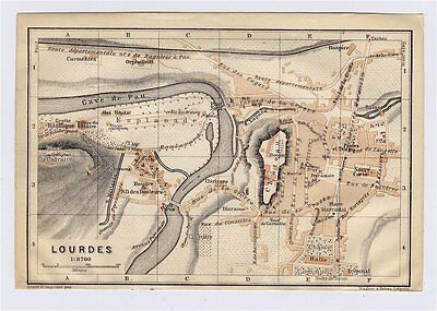
$5.00 Shipping Location: Canada 1914 ORIGINAL ANTIQUE CITY MAP OF LOURDES/ MIDI-PYRENEES/ FRANCE This original antique map gives you an opportunity to examine in exquisite detail a piece ... moreof history. Once matted and framed. This map would make a perfect gift for a family member or friend they'll cherish forever. Origin of the map: Southern France including Corsica- Handbook for Travellers" 6th edition, published by Karl Baedeker in Leipzig, Germany, Dulau& Co. London, UK, Charles Scribner's Sons, New York, USA. Date of issue: 1914 Size: The sheet measures: 6" x 4" 15.5 x 10 cm) S/H: The map will be shipped by Air Mail. The shipping charge is: USA- 4.00 USD. World- 6.00 USD, Canada- 1.80 USD. The price includes a strong and secure envelope. Attention! We combine shipping costs for multiple items. The HIGHEST VALUE SHIPPING FEE WILL APPLY FIRST and each subsequent item will be shipped FOR FREE. Pay me securely with any major credit card through PayPal! Payment methods: US/Canada Buyers: Paypal. International Buyers: Paypal. Click Here. Double your traffic. Get Vendio Gallery- Now FREE! USED. AN ORIGINAL ANTIQUE MAP.
Buy It Now
$16.78 Shipping Location: OAKHAM, United Kingdom Explore Ipswich of the 1920s with this vintage Ordnance Survey Map. Made of high-quality cloth panels, this antique original features intricate details ... moreof the city and its surroundings. Perfect for collectors or as a unique piece of decor, this folding map is a must-have for anyone interested in the history of Ipswich and the United Kingdom. With a date range of 1920-1929, this map captures the era and spirit of the vibrant city. Add it to your collection today and own a piece of history!
Buy It Now
$5.00 Shipping Location: Canada DATE OF ISSUE: 1905. ORIGIN OF THE MAP: "Northern France (.) - Handbook for Travellers", 4th edition, published by Karl Baedeker in Leipzig, Germany, ... moreDulau & Co., London, UK, Charles Scribner's Sons, New York, USA.
Buy It Now
$3.50 Shipping Location: Winter Springs, United States The superb handcoloring is period to the map, this is before color printing. The size of the map is 9.25" by 11". FREE scheduling, supersized images.
Buy It Now
Free Shipping Location: Riverside, United States 1903 Bradshaw's Map of Leipzig Germany. Rare & Authentic Folded Map.
Buy It Now
$5.70 Shipping Location: Sheboygan Falls, United States NEW MAP OF EUROPE LATEST BOUNDARIES and Occupation Zones The only date I've found is a stamped date of Jan 3. There is no year. This map does have pieces ... moreof tape on the edges & frayed edges.
Buy It Now
$5.00 Shipping Location: Canada DATE OF ISSUE: 1887. ORIGIN OF THE MAP: J. Trousset, "Nouveau dictionnaire encyclopédique - Vol.
Buy It Now
$6.95 Shipping Location: Dover, United States Charming small mid 19th century map with original outline hand color. Despite the relatively small size nicely engraved with a remarkable level of tiny ... moredetail. Dictionary of Mapmakers, vol.

Buy It Now
$6.90 Shipping Location: Springfield, United States Europe Roman Empire 1838 antique map w/ old color Monin& Fremin EMPIRE ROMAIN Issued Paris: c. 1836-8; by Monin& Femin. Fine original antique ... moreengraved map. Made approximately 175 years ago. Printed in the mid-19th century in France, on quality paper which retains its inherent structural flexibility and soundness. With original outline hand color. In near VG or better condition. Light minor surface dusting, overall clean[note: we grade very conservatively and always seek to disclose any noteworthy flaws] The printed area remains visually pleasing, a nice impression of an interesting image. Any defects along the sheet edges and in the margins may be seen in the photos. Sheet measures c. 12 1/4" W x 9 1/2" H. Engraved area measures c. 9 5/8" W x 7 1/2" H. 12404] note: All old sheets of printed paper possibly have short edge splits. Each sheet has existed for a very long time and has probably been handled repeatedly in the course of it's existence. It has a history unique to it as an object. Most of the time any edge splits are short. Minor, insignificant and have been closed- either long ago or more recently with small pieces of archival tape. Most often these splits are trivial and easy to overlook visually. Basically, they would not significantly affect the piece adversely. The item is offered as seen. Please look carefully and make your decision knowing this antique image is nice. But it is not in perfect"like new" condition. However, with whatever flaws it possesses, it remains entirely worthy of ownership and inclusion in any related collection. We feel it will prove very pleasing to its new owner. We stand behind everything we sell. Everything we offer is guaranteed to be an authentic original antique item as described. We do not sell modern reproductions. Please visit our eBay Store. We happily accept PayPal! WE OFFER FLAT RATE SHIPPING WORLD WIDE! Please request an invoice before paying for multipl
Buy It Now
$3.65 Shipping Location: United States Beautiful map. Fine color lithography. There is text on reverse, but you cant see it looking at the image as the paper is too thick. The size of the map ... moreis 11.5" by 14". FREE scheduling, supersized images.
Buy It Now
$8.77 Shipping Location: LLANFAIRFECHAN, United Kingdom Ordnance Survey Irish District Map Ordnance Survey one-inch map of Ireland. Killarney District. Published in 1947, with railways revised to 1946, and ... moreroad classification as of 1942. Printed on paper. And folded in the original covers. The map is in good condition(some light wear to the folds) Covers: Killarney. Kenmare, Kilgarvan, Glengarriff. Have a look at my other auctions: I am selling some similar maps. I am always happy to combine postage for multiple purchases.
Buy It Now
$3.50 Shipping Location: United States Printed on fine paper, there is text on reverse, but you cant see it looking at the map, as the paper is too thick. The size of the map is 10" by 12.5". ... moreFine and rare period map. FREE scheduling, supersized images.
Buy It Now
$21.22 Shipping Location: CHESTERFIELD, United Kingdom
Buy It Now
$3.50 Shipping Location: Winter Springs, United States The superb handcoloring is period to the map, this is before color printing. The size of the map is 9.25" by 11". FREE scheduling, supersized images.
Buy It Now
$6.95 Shipping Location: Dover, United States Issued 1711, London for Cluverius. Early 18th century engraved historical map with attractive hand color.
Buy It Now
$6.95 Shipping Location: Dover, United States Issued 1854-62, London & Edinburgh by A. Fullarton & Co. Map by Swanston. Fine mid-19th century antique color lithographed map.
|
|
|
|
VINTAGE WW1 BRITISH ARMY MAP - NORTHWEST EUROPE SHEET 3
VINTAGE WW1 BRITISH ARMY MAP- NORTHWEST EUROPE SHEET 3 SCARCE ORIGINAL WORLD WAR ONE VINTAGE WESTERN FRONT MILITARY MAP OF FRANCE- NORTH WEST EUROPE. SHEET 3. PRODUCED BY THE BRITISH ARMY GEOGRAPHICAL SECTION GENERAL STAFF, WAR OFFICE DATED MAY 1918. THIS IS NOT A COPY OR A MODERN REPRODUCTION- THE MAP CAME FROM THE ESTATE SALE OF A WW1 U.S. ARMY A.E.F. OFFICER WHO BROUGHT IT HOME FROM EUROPE WITH HIS WAR SOUVENIRS. THE SINGLE SIDED FOLDING MAP IS BACKED IN LINEN. THE SCALE IS 1: 250.000. SHOWS HONEST AGE, USE& WEAR, BUT STILL IN GOOD CONDITION, MEASURING ABOUT 26 x 33 1/2 INCHES WHEN OPENED. WE COMBINE SHIPPING FOR MULTIPLE ITEMS- PLEASE VISIT OUR EBAY STORE FOR OTHER HARD TO FIND WORLD-WIDE MILITARIA AND COLLECTOR REFERENCE BOOKS. THIS WILL MAKE A SUPERB ADDITION TO YOUR COLLECTION! INTERNATIONAL BIDDERS WELCOME- We Sell& Ship Worldwide. ... moreInternational Buyers Please Note: Import duties. Taxes, and charges are not included in the item price or shipping cost. These charges are the buyer's responsibility. Please check with your country's customs office to determine what these additional costs will be prior to bidding or buying. We will not under value merchandise or mark the item on the customs form as a gift. Doing that is against U.S. and International laws. We accept Mastercard. Visa, Discover Card, American Express, and Paypal. We Combine Shipping for multiple items. Minnesota residents please add 6.9% sales tax. Winning Bidder agrees to pay for this item within 7 days of the auctions close. Order with Confidence. Our BRICKS& MORTAR STORE has been in business for over 35 years. Satisfaction Guaranteed! The cost of shipping International orders by the U.S. Postal Service is based on the weight of the item when packed. We can send from 1 to 3 patches INTERNATIONAL for $1.50 s/h. 1 to 3 patches to Canada for $1.00 s/h) We can send International Packages under 4 pounds by International 1st Class Mail, and over 4 pounds by International Priority Mail. The Flat-Rate International Priority Flat Env
|
|
|
Vintage OFFICIAL ROAD MAP FOR ALLIED FORCES EUROPE _ GERMANY AND CENTRAL EUROPE
Map is in very good condition. It has been used. There are some routes that have been highlited. This map has a plastic covering on the top to help it last and be more useable, some of that coating is no longer stuck to the map. I found a date on the map 1965. this is M305 EDITION 3-AMS(USAREUR) STOCK NO. M305XGERMANYSEU
|
|
|
Johnston's European War Map 1914 WWI World War I Europe
Wonderful old WWI map. Good condition cover and map. A folding map backed onto cloth. Approx. 100 cm by 50 cm. The main scale is 35 miles to one inch. There are maps of Eastern France. Southwest Germany, Russo-German and Russo-Austrian frontiers, Belgium and the Netherlands, plus smaller inserts of the North Sea, Baltic Coasts, and the Kiel Canal. The map is in great shape for its age. You will love this item! eMail all questions. Outside the lower contiguous United States? eMail for shipping rate.
|
|
|
Unlocked HTC HD2 GSM Video Phone GPS WiFi Skype Camera Map for USA Canada Europe
HIGHLIHGT FEATURES ==================* 1GHz CPU* Video call(you can see caller at another side while calling. Tested with VZO) Built-in WiFi* T-Mobile 3G* GPS navigation* Skype* Camcorder and camera* Unlocked GSM* Free install APPs. NO NEED to contact MARKETPLACE like Windows Phone 7.5 ================== This is a full features unlocked HTC HD2 T-Mobile GSM T8585 3G smartphone with GPS. WiFi, bluetooth. Camera, camcorder, video player, audio player, etc. You can use it to get real-time GPS navigation. Connect Internet, play video and music, voice record, and more. It has a built-in WiFi card so no additional WiFi card is needed to connect Internet. This phone has 1GHz CPU so that you can get smooth video picture while making video calls(tested with VZO program. VZO program is included in this item) via WiFi or T-Mobile 3G. 3G features are ... moreonly available for T-Mobile which can not be unlocked for different SIM cards from different phone companies. GPRS/EGDG/MMS features are not available for AT&T SIM card. However you can use this phone to make phone calls with AT&T or any GSM SIM cards. The touch screen is in good conditions(see pictures) Item coming with: Unlocked HTC HD2 smartphone with Windows Mobile 6.5* Built-in GPS receiver* Built-in WiFi* Built-in Video Camcorder* Built-in bluetooth* Sync cable* AC charger(OEM) Battery(hold charges but no guarantee) DVD disk containing VZO. Skype, GPS maps, documents, etc. No guarantee for the hardware and software not included in this item. No guarantee for the features not mentioned above. IT IS NO RETURN. NO EXCHANGE, NO REFUND for buyer CHANGING OS or OPENING CASE. If you got any issue in using this phone. Immediately contact me. DO NOT try to fix problem by yourself! Specifications: General 2G Network GSM 850/ 900/ 1800/ 1900 3G Network HSDPA 900/ 2100 Display Type TFT capacitive touchscreen. 65K colors Size 480 x 800 pixels. 4.3 inches(~217 ppi pixel density) Multitouch Yes- Sense UI Sound Alert types Vibration. MP3, WAV ringtone
|
|
|
MAP Official Road Map for Allied Forces, Europe SOUTH-WEST FRANCE
Please read full description and view photos below the description writeup. See my FINE PRINT(general Conditions of Sale) by clicking on"ME" which can be found next to my user name in the SELLER BOX. Top right of first screen in this item. Combined Shipping details can be found there. Use Shopping Cart for multiple purchases, one payment. ALL communication must be via MY EBAY MESSAGES as the mail account is not monitored. Dated 8/53. Marked Sheet No. 4. very large sheet with 16 sections, printed on one side only. Condition: Good with wear. Some soiling. Intact, complete. 4zz 1xx CC 201209 Powered by The free listing tool. List your items fast and easy and manage your active items.
|
|
|
OLD WORLD AFRICA EUROPE ASIA COL COPPER ENGRAVING MAP KÖHLER WEIGEL 1720 Z22
Produktbeschreibung: Historische. Dekorative altkolorierte Kupferstichkarte von Johann David Köhler(Autor. 1684- 1755) Christoph Weigel( Verleger. 1654- 1725) Nürnberg 1720 AD aus: DESCRIPTIO ORBIS ANTIQVI/ in XLIV. Tabulis exhebitia. Karte von der Alten Welt- Afrika- Europa- Asien"Orbis Terrarum. Siehe Abbildungen! Größe des Blattes: 23.1 x 19,1 cm Größe der Karte: 19.1 x 15,6 cm ZUSTAND: sehr guter Zustand. Siehe Bilder- minimal gebräunt und fleckig- kleine Randbestossungen SELTENES STÜCK! SEHEN SIE SICH DIE FOTOS AN UND URTEILEN SIE SELBST! Historical wonderful original old-coloured copper engraving map of Johann David Köhler(Author. 1684- 1755) Christoph Weigel( Printer. 1654- 1725) Nuremberg 1720 AD out: DESCRIPTIO ORBIS ANTIQVI/ in XLIV. Tabulis exhebitia. Map of the Old World- Africa- ... moreEurope- Asia"Orbis Terrarum. See Pictures! size of leaf: 23.1 x 19,1 cm size of map: 19.1 x 15,6 cm CONDITION: very good condition- minimal brownish and stained- small defects at the edges This is a Original- no reproduction! Zahlungshinweise: Bei uns können Sie per: Überweisung oder Paypal bezahlen! Weitere Einzelheiten teilen wir Ihnen umgehend nach erfolgreichem Abschluß der Auktion mit! Lieferung/ Versandkosten: Deutschland/ Germany 7.00 Euro Europa(EU-Länder/ Countries of the European Union) 18.00 Euro Europa(Andorra. Norwegen/ Norway, Schweiz/ Switzerland) 30.00 Euro Sonstige Länder/ Other countries 35.00 Euro Kostenlose XXL Bilder bei TRIXUM.DE. Powered by The free listing tool. List your items fast and easy and manage your active items.
|
|
|
1942 Print Map World War II Atlantic Arena Allies Axis Africa America Europe
Home ~ Affiliations ~ Discounts ~ FAQs ~ Grading and Certification ~ Premium Shipping ~ About Us VINTAGE ART& ADVERTISING CURATED COLLECTIONS 1942 Print Map World War II Atlantic Arena Allies Axis Africa America Europe Details Year: 1942 Type: Original Print Map Grade: Near Mint/ Very Fine Authentication: Dual Certificates Image: Color Approximate Size(inches) 26.5 x 21 Approximate Size(cm) 67 x 53 Description and Condition This is an original 1942 color print map of the Atlantic Arena during World War II. Depicting the territories that belonging to or were in favor of the Allies and Axis powers, as well as those that were occupied by them. CONDITION This 69+ year old Item is rated Near Mint/ Very Fine. Light aging throughout. No creases. No natural defects. No surface rub. No tears. No water damage. Please note that this item has retained ... moreits original vertical and horizontal crease line. Which may be difficult to see in the digital image. Please handle with care. To find other items from this specific collection in our eBay store. Please. Keywords specific to this image: Greenland. World War Two, WWII, Brazil, Neutral, Side Forces. YFT1A6C42 195826_YFT1_155 Product Pricing& What We Deliver At times we receive inquiries about our pricing. Especially for vintage advertising or historical halftone prints, and are asked why our prices are consistently higher than some other sellers of similar items. For the first five years of our business, we asked our primary consumer base what they wanted. Our primary consumers- historical societies, historians, archivists, curators, university professors, historical decorators, and collectors, etc. have diverse and specific needs and we've built our business to accommodate those needs, like no other seller worldwide. Below is what is unique about how and what we offer as the world's leader in print ephemera: Product Packaging. Every product is placed against custom black acid-free board with crystal-clear. Archival protective closures. We are the only sellers in
|
|
|
Antique Early 1900's Pull Down Classroom Map of Europe
For sale is an incredible antique school wall map of Europe that was manufactured in Chicago. Illinois by A.J. Nystrom& Co. This wonderfully aged map is printed on a canvas material and comes with the original metal bracket which still works and is very easy to mount. Due to the fragile nature of the map, it must be removed from the metal bracket to roll it up and down by hand. This map would look great hanging in your library or study or would serve as a great educational work of art in your child's bedroom! While we're not 100% certain of the specific year this map was manufactured. Based off of the mention of the French Mandate in Syria(1923) and the Bristish Mandate in TransJordan(1921) we believe this map dates to the 1920's time frame. Additional details: Measurements(with bracket) Approximately 51" Long x 39.75” ... morewide Scale: 1:5.400,000 or 85 miles/inch Circa: 1920's Item Condition: Wonderful antique condition! Colors remain bold and vivid. As noted above. You will need to roll up/down the map by hand due to its fragile nature. Surface of map has light soilage from years and years of use. Canvas has some normal wear such as wrinkles, bends, frayed edges, light soilage, spotting, etc. We believe that at one point a wooden rod would have been attached to the bottom of the map. As you can see, it's no longer attached. Center of map has a crack in the paper coating that runs most of the length of the map. The canvas material below remains intact, holding the map together nicely. The bottom of the map has some liquid staining as well as some minor tears around the edges. We tend to think that each of these flaws adds to the overall wonderful antique look of this piece. Please take a gander at the pictures for further details. RcmdId ViewItemDescV4,RlogId p4%60bo7%60jtb9%3Feog4d72f%2Bf7%60%3E-13e8347d537-0xfb-
|
|
|
VICTORIAN MAP ~ EUROPE @ DEATH OF CHARLES THE GREAT 814
A beautiful old map on fine quality paper EXCELLENT condition and rescued from a disbound book: ATLAS OF ENGLISH HISTORY by SAMUEL RAWSON GARDINER 1898 Map produced& printed by: Longman. Green& Co London. New York, Bombay, Calcutta& Madras THIS VICTORIAN MAP IS AN ORIGINAL OVER 110 YEARS OLD AND NOT A REPRODUCTION This map including borders measures approximately 8 1/4 inches by 6 1/2 inches(210mm x 165mm) Printed on fine quality paper Free from any text on the reverse A superb map in excellent DAMAGE FREE condition ~ NO CREASES OR TEARS ~ No foxing or spotting ~ Please email with any questions regarding this item(Gardiners atlas of English History) Repeat Repeat BEST OFFERS PLEASE FOR A QUICK SALE AT A FAIR PRICE If you like the item. But do not like the price, then make a realistic offer to us using the MAKE OFFER BUTTON
|
|
|
OLD 1944 D-DAY WAR COMMEMMORATIVE INVASION OF FORTRESS EUROPE MILITARY ARMY MAP
VINTAGE 1944 D-DAY WAR MAP COMMEMMORATIVE INVASION OF FORTRESS EUROPE DATED EVENTS(COMMEMORATING D-DAY JUNE 6. 1944) PRINTED IN U.S.A SHAW-BARTON, COSHOCTON, OHIO SIZE 38 1/2" X 17" TELLS DATES AND EVENTS GOING ON(VERY COOL) MAP IN VERY GOOD SHAPE. ALSO THE ACTUAL SHIPPING ENVOLOPE POST MARK SEPT 16, 5PM, 1944 COMES WITH MAP. GREAT T FRAME OR ADD TO YOUR COLLECTION
|
|
|
ORIGINAL J B Nolin 1791 Map * L'EUROPE DIVISEE SUIVANT SES PRINCIPAUX
Auction Wizard 2000 Listing Template- AW2KLOT#3155 Please note that Customs delays for international shipping have been SIGNIFICANT lately- days or even weeks longer than they should be! Please take this into consideration Our goal is 5 star service! If you feel we have not lived up to a 5 star rating. Please contact us as we only want 100% satisfied customers and NO misunderstandings! Description below pictures* ORIGINAL J B Nolin 1791 Map* L'EUROPE DIVISEE SUIVANT SES PRINCIPAUX* $300.00 An Original Vintage Antique Map: Not a Reproduction! See Our Ebay Store for other Antique Maps! Free US Shipping on Purchases of $100 value or more of Maps and Prints Description: This is an authentic antique map approximatley 222 years old! L'EUROPE DIVISEE SUIVANT SES PRINCIPAUX(Europe) By Jean Baptiste Nolin. Published in 1791 in Paris. France. ... moreFrom ATLAS GENERAL by Jean Baptiste Nolin/Louis Joseph Mondhare. Hand colored chart showing 10 figures of the Globe/Sphere and planets. Text below image is French. Original copper plate engraving printed on hand-made laid paper. Overall size approx. 15 1/2" x 10" with the image size approx. 8 3/4" x 7 3/4" Some very light overall soiling. Edges show some minor wear. Upper corners hand numbered. Overall in excellent condition for its age. Shipping: Please use the calculator under the"Shipping and payments" tab above to determine shipping for your location. All packages are sent with Delivery confirmation where possible. We always combine shipping. So on multiple items please wait until we send you an invoice with the correct shipping applied. Maps and Prints will be shipped either flat or rolled depending on the items being shipped. We use only sturdy shipping materials to make sure the package arrives at its destination in undamaged condition. Insurance is on US! Please ask if you have any questions about shipping. Payment Details: We accept most major credit cards through Paypal. International bidders are welcomed. New Bidders are welcomed and en
|
|
|
Italy Bi-metal Coin. Italian 1000 Lire Europe Map. Very Nice.
This auction is for a Bi-metal Italian 1000 Lire Europe Map Coin. Very nice details. A great addition to any collection! The item in the photo is the actual item you will get. A very low starting price! Any questions are welcome. Please check my other auctions for some more interesting items. Shipping and handling cost is a flat rate $5 to America. Canada, Australia, Western Europe and Japan via regular slow mail. Other countries bidders please mail me before bidding. Will combine shipping at $1 for each additional item. Express registered mail is available upon request at a higher cost. Will ship to a verified eBay/Paypal address. Buyer to pay within 48 hours of auction end or contact us prior to that if more time needed. Thanks and Happy Bidding! 560.RcmdId ViewItemDescV4,RlogId p4%60bo7%60jtb9%3Feog4d72f%2B%3E560-13e87209c5c-0x104-
|
|
|
1968 OLD VINTAGE PRINT 1939-1945 WWII WAR WORLD EUROPE MILITARY COLOR PRINT MAP
1968 early vintage color print military map WWII 1939-1945! map: WWII type: Military language: Bulgarian year: 1968 print: Sofia. Bulgaria MEASURES CONDITION On Dec-29-12 at 21:56:49 PST. Seller added the following information: Powered by The free listing tool. List your items fast and easy and manage your active items.
|
|
|
Germany WWII - Large Colorful Map of Europe, 45 by 35 inches, published by DDAC
Here is a beautiful colorful map of Europe 1:5 000 000 published in Germany 1940 by DDAC(Der Deutsche Automobilclub e.V. It measures approximately 45 by 35 inches and is in Excellent condition with no rips. Tears, separations, tape, or markings. International bidders please contact me prior to bidding regarding shipping costs to your location. Thank you.
|
|
|
1812 Malte-Brun Map of Turkey in Europe, Arabia, Persia, Central Asia
1812 Malte-Brun Map- Asie Occidentale Conrad Malte-Brun's Atlas Complet du Precis de la Geographie Universelle. From which this map comes, was published in Paris in 1812 and was one of the best and most up-to-date atlases of the early-19th century. It used charming vignette scenes in the title, a practice to be copied by other French mapmakers and the John Tallis company in England. Malte-Brun, a Danish geographer and publisher who settled in Paris, used French engineer and geographer Alexandre Lapie, as well as engravers Jean-Baptiste Tardieu and Jean-Baptiste Chamouin, in the creation of his atlas. This map has excellent detail and clear engraving. The map includes Turkey in Asia. The Kingdom of Persia, Arabia, Afghanistan, Independant Tartary, the Russian Empire. The map has a scale of distance, and a charming title vignette of a camel. ... moreThe map measures 11.5" by 8" Has later outline hand colouring, and is in good condition except that there is a fair amount of foxing of the page. The map is guaranteed to be over 210 years old. Shipping United States- Regular airmail $5.00US. Registered/insured airmail with tracking(optional) is an additional US$15.00 for a total of US$20.00. Canada- $3.00US for regular mail. $9.00US for registered mail. Canadian customers please add GST or HST as applicable. Sorry, we cannot arrange for pick up of ebay items. Rest of the world- Regular air mail $8.00US. Registered/insured airmail with tracking(optional) is is an additional US$15.00 for a total of US$23.00. Terms and Conditions Please note- We can only take responsibility for delivery if the optional registration/insurance is added. Regular airmail is usually very safe and reliable. But items sent by regular airmail are at the buyers risk- regular airmail provides no tracking number, no proof of shipping or delivery, and no insurance in case of loss or damage. Please note- Mailing from Canada to the United States and all other international destinations can sometimes take over three weeks for delivery. We will com
|
|
|
Large Original 1902 Rand McNally Map of Europe
Large Original 1902 Rand McNally Map of Africa. Measures 16.25 by 22.5" Will frame nicely. From the 1902 Rand McNally Twentieth Century Atlas of the World. Shipping is $ 4.95 to anywhere in the US. Your order will always ship within ONE BUSINESS DAY. Well packaged in a sturdy waterproof mailer and sent with a delivery confirmation.
|
|
|
Rare WW 1 Europe old map made by "The Ferris delicious hams and bacon" NY 1915
Rare WW 1 All Europe in the throes of war old map made by"The Ferris delicious hams and bacon" NY 1915 In 1836. F.A. Ferris& Company, Inc. was founded by a man named John Cape in Ridgewood, New York. Ferris was widely known for its delicious old world recipes and tradition of making top quality smoked products, ham, pastrami, corned beef, bologna, and other quality deli items. This very rare map was the nº 12 of a series of maps presented with the compliments of F. A.Ferris& Company to offer to their customers in 1915 60.6 x 45 cms when unfolded, 20,9 x 9,3 when folded Very good condition. Except for a very small rip on the center, not visible on the pictures Shipping and handling cost Wordlwide by prioritary registered air mail is $8 USD They will be sent in a good package with cardboard I combine shipping so please ... moresee my other items Happy bidding
|
|
|
WW2 German 1:1000000 Fliegerkarte (Pilot Map) - Central Europe - RARE!
You are bidding on a SUPERB 1938 1:1000000 German Fliegerkarte(Pilot Map) as used by both Fighter Pilots and Bomber crews for navigation. This. As long with the reference sheet in teh last photos, were recovered from a downed Ju88 bomber pilot who crashed over England(sadly, I do not have any further info on the pilot) It measures a LARGE 35" x 37" 90cm x 95cm) This map allowed the pilot to properly calculate his flight path. It is made heavy laminated paper. Made of heavy paper. This map is in EXCELLENT condition for its age. It measures a LARGE 3 feet x 3 feet in size, and covers Central Europe. Overall it includes almost all of Germany along with Austria, with small corners of Denmark, Slovakia, and France. Indicates locations of lakes, seas, towns, villages, cities, railways, and elevations. Also features longitude and latitude ... moredegree markings, as well as the Luftwaffe Pilot Grid. Written at the top is Fliegerausgabe(Pilot Version) As well as Sonderausgabe 1941- Nur für den Dienstgebrauch(Special Edition. Only for internal use) The grid on the reverse(see last photo) shows that this map is location NM 32-33. There is some wear due to the age and use. But it is still quite solid as it is the laminated version. The last 3 photos show a German bombing reference sheet(reconnaissance photos) that include targets in Coventry Birmingham(such as the Austin Motors factory) Both items were recovered from the same Ju88 pilot. A VERY RARE and FANTASTIC addition to any collection. Display, or simply as a conversation piece! Please email me if you need additional photos or information. PAYMENT- Payment should be made within 7 business days at the end of the auction unless buyer contacts me for other arrangements. I accept all forms of payment. SHIPPING- My goal is to ship within 7 days from auction end. However. Depending on circumstances, it may take up to an additional 1 week from receipt of confirmed payment. If you need it shipped
|
|
|
Philips Europe 2007 large scale map ISBN 054008889-7
Philips 2007 Europe large scale map ISBN 05408889-7
|
|
|
Official Road Map For Allied Forces in Europe 6 maps & 3 other large maps
These maps are folded with wear and some damage. They show covered areas in great detail
|
|
|
ESSO WWII War Map II Featuring THE WORLD ISLAND and FORTRESS EUROPE
WWII Esso War Map THE WORLD ISLAND and FORTRESS EUROPE f3d.RcmdId ViewItemDescV4,RlogId p4%60bo7%60jtb9%3Feog4d72f%2B%3Ef3d-13e8d8c3e1d-0x108-
|
|
|
Vintage 1943 Atlas Map World War WWII Italy & Switzerland OLD Europe with Rome
A Wonderful Gift! Vintage 1943 Atlas Map WWII Era of Italy& Switzerland OLD Great OLD Map from the"Collier's World Atlas& Gazetteer" From Early 1943 WWII 70 Years Old! On one side is Italy On the other side Switzerland(Contact Us For More Scans) This Map Measures about 10 3/4 x 14 1/8" Great Colors. Map shows The Mediterranean Sea. The Adriatic Sea, An Inset of Roma. Rivers, Mountains, The Alps, Lakes, Islands Etc. A Great Addition To Your World War II Collection! A Fantastic Gift For The WWII Buff! A GREAT OLD MAP! Very Educational. See what these parts of the World used to look like! There Is A Bent Corner. Top Left in 2nd Picture You Shouldn't Be Able To See It When Matted Will look GREAT Matted& framed A Nice Gift! Teachers& Politicians LOVE Them TOO! GREAT For Your Summer Home! A Fantastic House ... moreWarming Gift! Super For The Office! Nice Map of"The Old Country" Shipping by 1st Class or Priority Mail We Will Combine Shipping on Up To 4 Maps for the same shipping fee Email Us With Any Questions or For an International Shipping Quote Check out my other items! Be sure to add me to your favorites list! Thanks For Looking! International Buyers– Please Note: Import duties. Taxes, and charges are not included in the item price or shipping cost. These charges are the buyer's responsibility. Please check with your country's customs office to determine what these additional costs will be prior to bidding or buying.
|
|
|
1943 RAVENSTEIN EAST EUROPE COLOR MAP 50X32
This is an authentic German color map of East Europe in book form dated 1943. Approx. 50x32 in. Very good condition. Has pin holes, a few stains, rough edges. Family Estate. No Returns. Please make payment to paypal within 3 days. Thank you and please look at my other items.
|
|
|
1875 Mitchell Map World Mercator Projection America Europe Asia Africa Australia
Lake Erie Maps& Prints An Authentic Antique Map: Not a Modern Reproduction! No Additional Shipping Fees on Multiple Maps Shipped with the Largest Free Shipping on 5 or More Maps and Prints Description: It is a double sided sheet with a World on the Mercator's Projection on one side and on the reverse side the Eastern and Western Hemispheres. So if framing you would have to choose a side. It is an authentic Antique Map approximately 135 years old. It is a lithographic print with original hand coloring as issued with the desirable grapevine border. It is from Mitchell's New General Atlas. Published in Philadelphia by Augustus Mitchell, 1876. However, there is a copyright inscription with the date of 1875 along the bottom margin in small print that states"Entered according to an Act of Congress in the year 1875 by Augustus Mitchell ... morein the Office of the Librarian of Congress at Washington. A copy of the title page is also included for authenticity. The map is not mounted, matted nor framed being sold as a single sheet as seen in the first pic. There is a single sheet map of the Eastern Hemisphere on one half of the reverse size. Overall. A Beautiful Map with Superb Color! Size: The map image measures approximately 14 by 18 inches on a 15 1/2 by 24 1/2" page with a centerfold as issued and a margin all around as seen in the pic. Condition: It is in Good condition. Basically as seen in the pics, with overall tonal aging and slight darkening around the edges. There is some internal stress in the area of Africa that has been reinforced on the reverse, it is really not very noticeable unless one looks for it, otherwise it is very clean with nice strong color and a nice antique quality that would frame up nicely. It is printed on heavy paper with original handcolor and a centerfold as issued. The pics are of the actual map. Payment Details: We accept most major credit cards through Paypal and Ebay. Please ask if you have any questions about payment. International and New Bidders are welcomed and encou
|
|
|
Situation map 9/10 May 1940 - NW Europe on CD
You are bidding for this map on CD in PDF format. The printed version of this book is available on request. This large scale map shows the positions of the Allied and German forces in NW. Europe on 9 May 1940. On the eve of the German attack. It shows the German Army Groups. And Armies. The location of the Allied contingents and particularly of the BEF. Headquarters. Are also marked. Map Area: NW Europe. Dutch/Belgian/French-German Border. Date of Original: 1940. Scale: large scale. ISBN: 9781847912909. Type of Map: colour. Strategic. Special Features: Printed Size: A1.
|
|
|
Vintage Map Of Europe By Meractor,with A Portion Of America "Penn Print".
This is vintage map of Europe. By Mercator, a masterly engraving from the famous Mercator Hondius Atlas of 1633, with a portion depicted in the upper northwest corner from Penn Prints. It is in very good condition, measures app 20"x 16" Please check the picture. If you have any question, feel free to contact me. Posted with ``d.RcmdId ViewItemDescV4,RlogId p4%60bo7%60jtb9%3Fvo%7B%3Dd70f%2B%3E%60%60d-13e94f559af-0x104-
|
|
|
1813, EUROPE, Le Sage, Antique Map
A really lovely annotated map of Europe published in the 1813 English first edition of Le Sage’s excellent folio atlas. The map and text area measures approx 67cm x 47cm excluding margins. With a vertical centrefold and coarsely trimmed edges as issued. Hand coloured. With a lot of printed annotation within the map area and dense text on 3 sides covering the geography of Europe plus the principal powers and their political systems. Condition is good. Heavy wove watermarked paper. Lovely dark and clear impression without fading. Very clean and colours remain fresh. Evenly toned. There is some visible spotting. Particularly in the text areas to the right and the bottom. Some vertical creasing on the right side. Two short worm tracks in the bottom margin. Edges browned; untrimmed as issued. Verso blank. Free postage in the UK. Many thanks for ... moreyour interest. Any questions then please don’t hesitate to ask. PHOTOGRAPH OF THE SHEET SCAN OF PART OF THE SHEET
|
|
|
1683 Genuine Antique map Turkey in Europe. Extraordinary cartouche. A M Mallet
Genuine Antique map"Turquie Septentrionale en Europe" from Description de l'Univers by Alain Manesson Mallet. Paris, 1683. This bold, yet simple, impression of Turkey in Europe shows coastline on the Adriatic and Agean seas, and labels"Hongrie" Transylvania" Moldavie" etc. The date of 1682 appears on a decorative banner at the bottom of the page and an ornate cartouche embellishes the top of the page. A copperplate image in very good condition with faint age toning. French text on verso. Image measures 5 5/8"x 3 7/8" THIS IS NOT A REPRODUCTION! All of our items are genuine antiques as described.
|
|
|
1860 Genuine Antique Map of Russia in Europe, & Scandanavia. A Mitchell
Genuine antique map of"Russia in Europe. Sweden and Norway" from New General Atlas published by S Augustus Mitchell Jr in Pennsylvania. 1860. Two insets show Denmark, and Holland and Belgium. Original hand color outline and washes accentuate countries on this very attractive map. Image is surrounded by a lovely twining leaf and flower border. Faint age toning. Image measures 10 3/4"x 13 5/8" NOT A REPRODUCTION! All of our items are genuine antiques as described. f04.RcmdId ViewItemDescV4,RlogId p4%60bo7%60jtb9%3Fuk.rp*6%3D%3F%3Ef04-13e984b1129-0xfc-
|
|
|
1867 Genuine Antique Hand Colored Map of Russia in Europe. Johnson
Genuine Antique map"Johnson's Russia" from Johnson's Family Atlas of the World published by A. J. Johnson. New York, 1870. Bright hand colored map of Russia shows mountains, waterways and lakes in nice detail. Shorelines are nicely illustrated, and cities are named. This attractive image is surrounded by an elegant border. Very good condition with only slight age toning. Center fold as issued. Image measures 22 1/2" x 16 3/4" THIS IS NOT A REPRODUCTION! All of our items are genuine antiques as described. n6gonr.RcmdId ViewItemDescV4,RlogId p4%60bo7%60jtb9%3Fuk%601d72f%2B26rk%3En6gonr-13e984b1141-0xfd-
|
|
|
German ww2 map of Europe (1943)
German ww2 map of Europe(1943) Showing also the Romania-annexed province Transnistria. Issued: F reytag& Berndt. Wien, 1943. Scale: 1: 6.000.000. ORIGINAL! Dimensions: circa 105 x 85 cm. Will be sent folded in a protected envelope. I ship worldwide.
|
|
|
German ww2 map of western Europe "Karte von Westeuropa" (1944)
German WW2 map of western Europe"Karte von Westeuropa" 1944) Issued by: J. Perthes. Gotha, 1944. ORIGINAL! Backed with quality canvas. Dimensions: circa 66 x 98 cm. Will be sent rolled in a strong cardboard tube. I ship worldwide.
|
|
|
1833 Genuine Antique map Europe in the Middle Ages. Malte-Brun
Genuine Antique map"Geographie du Moyen Age Principalement au ix siecle" from"Complet du Precis de la Geographie Universelle" by Conrad Malte-Brun. Published in Paris in 1833. A very interesting map of Europe in the Middle Ages showing the Empire de Charlemagne, Empire d' Orient, Empire des Califes, Empire du Tibet etc. This lovely steel plate image is original hand colored in outline, has nice wide margins and is in very good condition. Image measures 8 3/4"x 12" NOT A REPRODUCTION. All of our item are original antiques as described.
|
|
|
1826 Genuine Antique map of Europe at the time of Charlemagne. by A.H. Brue
Genuine antique map"L'Europe sous Charlemagne" by Adrien Hubert Brue. Map is dated 1826 and published in Paris. Impression is hand colored in outline and printed on sturdy paper with full margins. This map shows Europe at the time of the rule of Charlemagne and an inset depicts the empire of Charlemagne. A delicate seal states"propriete de l'Auteur" Map is in good condition with some foxing and minor ink transfer from folded storage. Center fold as issued. Image measures 14 1/4" x 19 3/4" NOT A REPRODUCTION. All of our items are genuine antiques as described.
|
|
|
1828 Genuine Antique hand colored map Europe after peace treaties. by A.H. Brue
Genuine antique map"Carte Generale de L'Europe d'Apres les Derniers Traites de Prix" by Adrien Hubert Brue. Map is dated 1828 and published in Paris. Impression is hand colored in outline and printed on sturdy paper with full margins. This attractive map shows the countries of Europe after the last peace treaties. A delicate seal states"propriete de l'Auteur" Map is in good condition with some foxing and minor ink transfer from folded storage. Some separation on lower center fold with no image loss. Center fold as issued. Image measures 14 1/4" x 20" NOT A REPRODUCTION. All of our items are genuine antiques as described.
|
|
|
WW2 WAR OFFICE NORTH WEST EUROPE HAVRE-AMIENS ARMY / AIR MAP 1943
FIELD MAP 2ND EDITION SHEET NO 4- 1CM TO 2.5 KILOMETRES- THIS HAS BEEN USED- TACK HOLES TO EDGES& FOUR SMALL HOLES ON CREASE/ FOLD LINES- VERY GRUBBY TO REVERSE ONE OF MANY ITEMS I AM LISTING AT THE MOMENT COMBINED POSTAGE IF REQUIRED
|
|
|
Antique Map: EUROPE A.D. 800
Antique Map: EUROPE A.D. 800 Antique Map: EUROPE A. D. 800 Original Map from an old text book. OVER 100 Years Old In excellent condition. No tears, very clean, measures 14.75 inches wide by 10.5 inches high, crease down the center. Color is clear and bright. Payment is expected within 3 days of sale. Paypal accepted. Thanks for looking! Your purchase will be shipped within 24 hours of receipt of payment except Sundays and Holidays. Shipping costs are based on weight. Location and type of service you choose. Delivery Confirmation is included in all Domestic Shipping Charges. Combined shipping is very welcome. There are a few exceptions, but only when one purchase may damage another or multiple items will not fit into USPS one-rate shipping materials. Satisfied customers are very important to us and we want you to shop here again. Please contact ... moreus with any concerns and give us the chance to correct any errors. Refunds are cheerfully given. Questions are always welcome! 4ffc.RcmdId ViewItemDescV4,RlogId p4%60bo7%60jtb9%3Fuk.rp*77%3E4ffc-13e9cbf0698-0xfc-
|
|
|
1761 DESNOS MAP OF EUROPE AND MEDITERRANEAN SHOWS POLAND ALS LARGE COUNTRY
. 1761 DESNOS MAP OF EUROPE AND MEDITERRANEAN SHOWS POLAND ALS LARGE COUNTRY Title: EUROPE From de luxe editions of Buy de Mornas Atlas Methodique et Elementaire de Goegraphie et l'Histoire. Buy de Mornas. Claude was, a professor of geography, and was the royal geographer to the King. Full hand colored. Engraving is Guaranteed authentic. A Certificate of Authenticity will be on request forwarded for eachindividual map or print. Size: Sheet app. 55.5 x 39 cm. 21.75 x 15.25 inches. Condition: Very good. Some light foxing at borders, Verso blanco. All maps and prints are genuine. Authentic, published at the date stated in this listing! For better quality pictures please go to our web site: WWW.MAPANDMAPS.COM I offer a no questions returns policy. All maps and prints are genuine. Authentic, published at the date stated above. Worldwide ... moreshipping by signed registered mail or Global Express courier. Shipping fee is per combined shipment. Including handling and insurance. Free shipping worldwide if three items or more purchased. .
|
|
|
Europe Map: L'Europe by Robert de Vaugondy c1757 from Atlas Universel NR
Genuine Antique Map! Low starting price! TITLE: L'Europe divifee en les principaux Etats SUBJECT: Europe Map REGION: Europe MAKER: Sr. Robert de Vaugondy. Fils de M. Robert DATE/PLACE PUBLISHED: c1757. Paris SOURCE: Atlas Universel Image size: 57 cm(22.5 inches) by 48.5 cm(19 inches) Page size: 68 cm(27 inches) by 52 cm(20.25 inches) Nice large map of Europe covering two pages from Robert de Vaugony's Atlas Universel. Listed as one of the first atlases to use scientific surveys. Features an ornamental title cartouche and original or early outline colour. Rarely offered for sale. Offered in good to fair condition. Might benefit from some conservation. Has some stains and foxing. There is a pin head sized hole near the area of Turkey. Outline colour somewhat faded. Darker along the center fold and has a couple small tears along the ... morefold that are repaired with clear tape on the back. Also has other fold marks and may have been stored folded up at some point. My research indicates that this map was issued for the Atlas Universel and I have not found any record of this map being issued folded. It is blank on reverse side except for it's title“Europe” and it's page number“14” Nice wide margins have not been cut. Please see all the detailed photos before bidding and consider them part of the description. I am not a map expert but please feel free to ask questions. I can supply additional close up photos of condition on request. Makes a beautiful gift or unique addition to your own antique map collection! Complete Title: L'Europe divifee en les principaux Etats. Par le Sr. Robert de Vaugondy, fils de M. Robert, Geogpaphe ordinare du Roy. Avec Privilege MANY MORE MAPS FROM THE SAME COLLECTION ARE ALSO LISTED FOR SALE! I AM ALWAYS HAPPY TO COMBINE YOUR SHIPPING. NOW WITH FREE SHIPPING FOR CANADIAN CUSTOMERS* Please NOTE: I accept ONLY PayPal. You must have a PayPal verified delivery address. Your shipment will be carefully packaged in a heavy duty tube and insured but duties and/or taxes if applicable a
|
|
|
1853 Antique COLOR Map/ WESTERN EUROPE /Findlay
THIS ITEM IS A GENUINE ORIGINAL VINTAGE MAP FROM THE SOURCE/DATE LISTED Name- Western Europe(Gallia) Date- 1853 Source- Classical Atlas. To Illustrate Ancient Geography By- Alexander Findlay Comment- This map was prepared by Mr. Findlay. A geographer, to show the various divisions of the world as known to the ancients. They show such gems as major landmarks, some topography, rivers and cities, etc. Size- About 9.5x12" Double page, blank back Condition- Fine. Very light corner wear Yes! We Do Combine Shipping on Multiple Purchases! NO RESERVE! Happy Bidding! Buyer pays shipping/packing. We use very secure packaging methods and materials. And all shipments within the United States will be made with the protection of the new USPS Parcel shipping category. First Class or Priority. Depending on weight) Note that certain items may be shipped ... morein the USPS Media Mail category. If appropriate. Payment due within 14 days after our initial after auction contact. Pennsylvania residents MUST add applicable SALES TAX or send resale number. Thanks. Good Luck! To See Our Other Auctions and Store Items CLICK HERE! Powered by
|
|
|
Large Vintage 1960's Pull-down Classroom Map of Asia/Europe, Physical-Political
This large( 55' x 51' vintage map dates back to the 1960's and displays the physical and political features of Asia. The map. Though aged, is still vividly colored as visible in the photos. The map is attached to a wooden. Spring-loaded roll-bar which is set in a mountable metal bracket. The metal bracket can be removed if desired. I obtained this map. And others of similar age, as surplus from Western Kentucky University. If you have any further questions. Feel free to contact me!
|
|
|
NATIONAL GEOGRAPHIC MAP LOT 1953 - 1957 star chart world europe great lakes
CELEBRITY CENTRAL magazines and clippings PLEASE READ THE INFO! SELLING CLIPPINGS AND MAGAZINES ON EBAY SINCE 1997 as shown- star chart 1957/ eastern south america 1955/ great lakes 1953/ north europe 1954/ antartica 1957/ world 1957/ europe 1957/ atlantic ocean 1955 all magazines should be complete with no cuts or missing pages and no major damage unless described above. there may be average reading wear tho. if this is untrue. Contact me for full or partial refund. multiple wins will be packaged together. Please do not pay until correct postage is determined Ask questions before bidding as all sales are final[unless i make a mistake] Shipping and Payment Terms IMPORTANT UPDATE- due to the high cost of postage from Canada. I am now offering a cheaper alternative on auction postage. Twice a month, first and third thursday of the month, i ... morewill be doing a mail out from the USA, meaning i can use their flat rate priority shipping rates OR regular parcel rates. the postage prices displayed in this auction reflect that cheaper alternative but there are two things to note 1] the handling fee will be 4$ instead of 2$ to reflect the cost of transport and border fees incurred[handling fees are already included in the postage price shown and overall price to buyer is still less than using canadapost] ALSO! ebay charges a 10% final value fee on POSTAGE. this money-grubbing greed tax will be added to the handling costs[this fee can be avoided if you wait for me to send you an invoice via paypal instead of the regular ebay invoice] 2] at this time. It is only financially feasible to do a cross-border mailout twice a month- if you require your purchase to be mailed sooner than the next usa mailout, let me know and i shall send it to you using canadapost, tho the postage may be more expensive. For items that do not fit in one of the usa flat rate packages. I will offer the cheapest available postage method, be it canadian or american. If these terms do not meet your needs, please contact me and i shall offer any
|
|
|
EUROPE and the Near East - June 1949 ~ National Geographic map
National Geographic Magazine supplement from the June 1949 issue. EUROPE And The NEAR EAST 32" x 28 1/2" L x H) Condition: Like New and near-mint! Bright white. Crisp, and pristine. One very minute bump/crease@ bottom edge when looking at the'title' area fold(front' I am very picky about selling National Geographic maps. I will not sell any with water damage. Stains, tears, tape-repair, holes, jagged edges, or just significant grime/darkening. I inspected each of these and opened them up to look them over. There could arise a pin-hole upon further handling however.
|
|
|
World War II Victory Europe Map and Pacific War Map
Welcome. This auction is for a lot of two WWII era maps. The first is labeled as a Victory Map set, edited by H.V. Kaltenborn and published by the Pure Oil Company. It includes a giant wall map of Europe and world map of all fighting fronts. It originally cost $.25. Its copyright date is 1944. The second map is the Pacific War Maps. Edited by H. V. Kaltenborn. It says its"giant size in global perspective. It includes large scale, detailed maps of the Philippine Islands, North China, Japan, and Southeast Asia. It was also published by the Pure Oil Company and is also copyrighted 1944. Returns will only be accepted if the item has been grossly misrepresented. If you win more than one of my items I might be able to ship them together to reduce costs depending on their sizes and weights. Paypal is the only form of payment accepted. Please ... morepay within 5 days of a winning bid. Good luck and happy bidding!
|
|
|
Philips Invasion map of Europe 1/3 price slightly damaged
On offer is an unusual map produced in 1943 and issued by Philips of London showing the invasion of Europe and giving details such as when various countries entered the war. The map is very interesting but sadly has some tears due to continuing opening and closing.
|
|
|
1837-EUROPE-GEOLOCICAL ENGRAVED MAP-COLORED-ORIGINAL-ITALY-SPAIN-POLAND-BIG
What-Title: Carte Geologique d'Europe. Date: 1837 original engraved colored map. Author: Malte-Brun. Conrad, 1775-1826 Publisher: Paris. Aime Andre. Scale 1: 15.000,000 Engraved map. Geologic units listed in legend and depicted in full color. Major relief depicted with hachures. Rivers. Lakes, islands, and regions shown. Includes 4 scales. Engraver: Thierry Size: 54.5 x 39.5 cm Good quality map. See all scans. SHIPPING SERVICE ECONOMIC: EUROPE 12$- REST OF WORLD 15$(for this unregistered service i'm not responsable of lost items)OCEANIA 16$ REGISTERED MAIL OR COURRIER PLEASE CONTACT ME. www.soloartepg.com Pagamenti: I pagamenti devono essere effettuati entro e non oltre i 7 giorni lavorativi dalla data di scadenza dell'inserzione(per cause sopravvenute contattatemi) Al termine dell'asta riceverete 1mail dell'importo totale ... moredei vostri acquisti e i dati per effettuare il pagamento. Fra i metodi di pagamento: paypal. Bonifico bancario e vaglia postale. ATTENZIONE PER GLI ACQUIRENTI ITALIANI: PER IMPORTI SUPERIORI A 100 EURO E' PREFERITO IL BONIFICO. Prodotti: Assicuro massima serietà! ciascuno dei pezzi che propongo nelle mie aste sono originali e cercherò di dare descrizioni quanto più accurata possibile. Per ulteriori chiarimenti o foto non esitate a contattarmi. Spedizioni e imballaggio: Si assicura un ottimo imballaggio per ogni oggetto da voi acquistato. Le stampe a seconda della loro dimensione. Dell'imballaggio che necessitano e del peso complessivo, verranno inviate con rotolo o busta imbottita con pluriball attraverso raccomandata o paccocelere3(si utilizzano metodi esclusivamente tracciabili) Per oggetti più pesanti verrà utilizato il paccocelere3(fino 30 kg) o coriere. Se desiderate 1 imballaggio particolare contattatemi. Vedrò cosa posso fare. N.B. PER OGGETTI PESANTI OFFRO LA POSSIBILTA' DI RITIRO O LA MIA CONSEGNA PERSONALE AI RESIDENTI NEL RAGGIO DI 50 KM DA PERUGIA.PREZZO DA CONCORDARE. Tempi di spedizione e consegna: Le spedizioni verrann
|
|
|
North Europe Finland Sweden Russia Poland 1808 antique engraved hand color map
The Northern States of Europe including Denmark. Norway, Sweden, Russia, Prussia& Holland Issued 1808. Manchester by Russell Fine original antique engraved map. Printed on quality paper which retains its inherent structural flexibility and soundness. With beautiful hand color. In Good+ to near VG or better condition. Some light minor age wear, crease at top left corner with small piece of paper backing 2 short edge nicks, but the image remain clean and very attractive[note: we grade very conservatively and always seek to disclose any noteworthy flaws] The printed area remains visually pleasing. A nice impression of an interesting antique map. Any minor defects along the sheet edges and in the margins may be seen in the photos. Sheet measures c. 13 1/4" W x 9 1/4" H. Engraved area measures c. 11 1/4" W x 8 1/8" H. 40271] ... moreGuaranteed Authentic! We do not sell modern reproductions. Condition All of our items are original antique pieces and it is important to keep in mind that many of them have been around for 100 years or more. Individual pieces may have seen many owners and been handled many times over the course of their existence and as a result each piece has developed a history of it's own. Short edge splits(often repaired with archival tape) Foxing, discoloration, etc. are all things to expect on items of this type. They rarely distract from the piece and often add to the overall character of the item. Keep in mind when you receive your item that you are not handling a modern copy, you are holding a piece of history, an item that has been around for a very long time and will, with proper care, be around for a long time to come. We try to note any significant flaws in the description, but less noticeable or common characteristics may not be mentioned. As we are a US based company all of our measurements are in Inches. If you need the size in Centimeters please multiply the supplied measurement by 2.53. Payment and Shipping We happily accept PayPal! Payment is appreciated within 5 days
|
|
|
EUROPE PHYSICAL - Mountains - Vesuvius Original 1891 antique map - Migeon
Excellent quality ORIGINAL antique engraved map Title: Europe Physique- Carte Hypsometrique( Europe- Mountains) Publication& Date: issued in Paris 1891 for Migeon" Nouvel Atlas Illustre Geographie Universelle" Description: Large attractive. Finely detailed and decorative map. Colour coded to heights, vignette of Mount Vesuvius. Suitable for framing. Map much better than scan, hard to photo the colour/detail) Condition& Size: Clean and good condition on quality paper- printed area 17"x13" 44x34cm) plus wide margins. Full colour Postage: UK- £3.00- Europe- £5.00- Rest of World and USA- £7.00(Can combine to save on postage) Visit our many other interesting listings of maps& prints on our Site(rediiwi) and in our E-BAY STORE Payment: Use Paypal or ask for details Thanks for looking
|
|
|
Map of Quebec & Europe (pre 1900's?)
Map of Quebec& Europe(pre 1900's? I will always combine shipping. Note: All sales in Canada are subject to GST of 5% and all sales in Ontario are subject to HST of 13% Please wait for an invoice before you pay. Shipping and Packaging Policy All items will be shipped within 1 business day from receipt of cleared payment. I strive to always charge actual shipping and packaging costs(including both eBay and Paypal fees) and if my actual cost is lower than the amount initially charged. I will refund the difference. I generally use the cheapest shipping option available(typically letter mail or expedited) however, any shipping option you would like to pay for is available. Combined Shipping Product Policy USA- Comics- 1 standard sized comic = $6.50. 2 = $8.50, 3 = 10.50, 4 to 15 = $20. Sorry about the price increase but Canada Post has ... morediscontinued one of their cheaper shipping options- Cards- Each additional standard sized card will be $0.25. But this additional charge will begin to reduce once you reach a total of 5 cards- Other- I will combine shipping for all other products. But this varies based on weight and size of each item Canada- Comics- Each additional standard sized comic will be $1.00. But this additional charge will begin to reduce once you reach a total of 7 comics- Cards- Each additional standard sized card will be $0.25. But this additional charge will begin to reduce once you reach a total of 3 cards- Other- I will combine shipping for all other products. But this varies based on weight and size of each item I package comics in a bubble mailer surrounded by oversized foam board for up to 10 comics(depending on thickness) and in boxes for larger purchases. Cards are packaged in a bubble mailer in hard plastic toploaders. Cases(smaller team sets) or foam board(larger team sets) Toys are packaged in boxes and Art is packaged in either mailing tubes or multiple foamboards. If you would prefer different packaging materials I can typically accommodate anything you would like to pa
|
|
|
1920's EUROPE English Map TURKEY SPAIN BULGARIA WW I
EUROPE MAP during WORLD WAR I Spain- Italy- Germany- England- Sweden Norway- Poland- Rumania- Bulgaria Turkey- Jugoslavia- Austria- France- Russia Printed in 1920's. Map shown: europe in 1914. 9x7 inch Full Color Good condition WE ACCEPT ONLY 1) PAYPAL 2) WIRE TRANSFER(please contact us for details) Please don't offer us the other ways after auctions ended! Important Note: Seller is based in the Turkey but sells on the ebay.com international site so the prices for books and shipping are priced in US$. ebay insists that sellers on ebay.com include costs for shipping each listing for only to the United States in $ 4.00 which does not reflect the true Airmail and Surface shipping costs to the US from the Turkey. Please ignore shipping costs to the United States given on ebay. The true shipping costs for this book is given below. SHIPPING ... moreDETAILS. WORLDWIDE SHIPPING COAST VIA REGISTERED AIR MAIL: 3.00 $- Powered by The free listing tool. List your items fast and easy and manage your active items.
|
|
|
1920's EUROPE Roman Empire Extent MAP Africa Asia
EUROPE MAP THE ROMAN EMPIRE At it's Greatest Extent(Under Trajan A.D. 9S-117) Printed in 1920's. 9x7 inch Full Color Good condition WE ACCEPT ONLY 1) PAYPAL 2) WIRE TRANSFER(please contact us for details) Please don't offer us the other ways after auctions ended! Important Note: Seller is based in the Turkey but sells on the ebay.com international site so the prices for books and shipping are priced in US$. ebay insists that sellers on ebay.com include costs for shipping each listing for only to the United States in $ 4.00 which does not reflect the true Airmail and Surface shipping costs to the US from the Turkey. Please ignore shipping costs to the United States given on ebay. The true shipping costs for this book is given below. SHIPPING DETAILS. WORLDWIDE SHIPPING COAST VIA REGISTERED AIR MAIL: 3.00 $- Powered by The free ... morelisting tool. List your items fast and easy and manage your active items.
|
|
|
1920s EUROPE British Isles Ireland England Scotland MAP
EUROPE MAP THE BRITISH ISLES Scotland- Ireland- England Printed in 1920's. 9x7 inch Full Color Good condition WE ACCEPT ONLY 1) PAYPAL 2) WIRE TRANSFER(please contact us for details) Please don't offer us the other ways after auctions ended! Important Note: Seller is based in the Turkey but sells on the ebay.com international site so the prices for books and shipping are priced in US$. ebay insists that sellers on ebay.com include costs for shipping each listing for only to the United States in $ 4.00 which does not reflect the true Airmail and Surface shipping costs to the US from the Turkey. Please ignore shipping costs to the United States given on ebay. The true shipping costs for this book is given below. SHIPPING DETAILS. WORLDWIDE SHIPPING COAST VIA REGISTERED AIR MAIL: 3.00 $- Powered by The free listing tool. List your items ... morefast and easy and manage your active items.
|
|
|
1920's EUROPE 14. Louis Govurment 1661 MAP France Spain
EUROPE MAP When Louis XIV Began His Personal Goverment 1661 Printed in 1920's. 9x7 inch Full Color Good condition WE ACCEPT ONLY 1) PAYPAL 2) WIRE TRANSFER(please contact us for details) Please don't offer us the other ways after auctions ended! Important Note: Seller is based in the Turkey but sells on the ebay.com international site so the prices for books and shipping are priced in US$. ebay insists that sellers on ebay.com include costs for shipping each listing for only to the United States in $ 4.00 which does not reflect the true Airmail and Surface shipping costs to the US from the Turkey. Please ignore shipping costs to the United States given on ebay. The true shipping costs for this book is given below. SHIPPING DETAILS. WORLDWIDE SHIPPING COAST VIA REGISTERED AIR MAIL: 3.00 $- Powered by The free listing tool. List your ... moreitems fast and easy and manage your active items.
|
|
|
1781 DATED RIGOBERT BONNE MAP ~ RUSSIA IN EUROPE ~ HAND COLOURED
AN ORIGINAL RIGOBERT BONNE COPPER PLATE DATED MAP FROM THE 18th CENTURY ATLAS GRENET- ATLAS PORTATIF(Atlas portatif pour servir a l'intelligence des auteurs classiques. Par M. L'abbé Grenet professeur au Collège de Lisieux. Dédié à L'université de Paris. THIS IS AN ORIGINAL ENGRAVING OVER 200 YEARS OLD AND NOT A LATER REPRODUCTION HAND COLOURED ON HAND MADE PAPER The page measures approximately 14 1/2 inches x 10 1/2 inches(370mm x 270mm) This scarce map is a genuine 18th century original Fine quality HAND MADE ~ LAID PAPER free from any text on the reverse. This attractive and important map was produced by Rigobert Bonne. A significant cartographer during the period of late 18th century. Original hand coloured detail. Titled with date of printing. This map will look superb when framed. A scarce and ... morecollectable investment CONDITION EXCELLENT ~ A CLEAN MAP WITH A CRISP IMPRESSION*HANDWRITTEN INSCRIPTION APPERTAINING TO MAP IN LEFT-HAND MARGIN* PLEASE VIEW TO SEE ANY MINOR HANDLING/AGE MARKS AT EXTREMITIES PLEASE NOTE: ANY TEXT ON THIS MAP WILL BE IN FRENCH Please email with any questions regarding this item(Grenet) BEST OFFERS PLEASE FOR A QUICK SALE AT A FAIR PRICE If you like the item. But do not like the price, then make a realistic offer to us using the MAKE OFFER BUTTON In 1773 Bonne succeeded Jacques Nicolas Bellin as Royal Cartographer to France(Louis XV& Louis XVI) in the office of the Hydrographer at the Depôt de la Marine. Working in his official capacity. Bonne compiled some of the most detailed and accurate maps of the period. Bonne’s work represents an important step in the evolution of the cartographic ideology away from the decorative work of the 17th and early 18th century towards a more detail oriented and practical aesthetic. With regard to the rendering of terrain Bonne maps bear many stylistic similarities to those of his predecessor, Bellin. However, Bonne maps generally abandon such common 18th century decorative features such as elaborate de
|
|
|
EUROPE authentic Antique Map genuine 124 years old made in 1889
This scan is enlarged to show representative detail. EUROPE Authentic 124-Year-Old Antique Map FREE SHIPPING ANYWHERE IN THE USA! Printed in 1889. This is a beautiful, 124-year-old color map of the European Continent together with the British Isles, Iceland and the Faroe Islands. It measures about 10 1/2 by 13 inches(about 27 by 33 cm) and is in FINE condition. It is quite detailed, showing topographical features(rivers, lakes, mountains, etc. as well as countries, cities and more. Ideal for genealogy and other educational purposes. Not to mention being highly decorative, it was printed on a single sheet of stock, hinged in the center and blank on the reverse, and bound whole in an antique book. There are no marks or stains, and the paper is clean and not brittle. Highly suitable for framing(see sample presentation below) it would look great ... morein your library, office, den or study. It is similar to many of the maps shown in expensive mail-order and on-line catalogues, with one important exception: this is an actual antique. NOT a modern copy or reproduction! An excellent investment. This map is certain to appreciate in value over time. Please ask all questions before making your purchase. SAMPLE DISPLAY IDEA SAMPLE DISPLAY IDEA FREE SHIPPING within the USA by USPS First Class Mail. Priority and Express services also available. I ship worldwide! pcuk89b
|
|
|
Physical Map of Europe 1851 antique engraved map
Physikalische Karte von Europa(Europe) Issued 1851. Germany Fine original antique engraved map. Printed on quality paper which retains its inherent structural flexibility and soundness. In near VG or better condition some light minor age wear but the image remains clean. Attractive and very presentable[note: we grade very conservatively and always seek to disclose any noteworthy flaws] The printed area remains visually pleasing. A nice impression of an interesting antique map. Any minor defects along the sheet edges and in the margins may be seen in the photos. Sheet measures c. 11 5/8" W x 9 3/8" H. Engraved area measures c. 10 1/8" W x 8 1/8" H. 40189] Guaranteed Authentic! We do not sell modern reproductions. Condition All of our items are original antique pieces and it is important to keep in mind that many of them ... morehave been around for 100 years or more. Individual pieces may have seen many owners and been handled many times over the course of their existence and as a result each piece has developed a history of it's own. Short edge splits(often repaired with archival tape) Foxing, discoloration, etc. are all things to expect on items of this type. They rarely distract from the piece and often add to the overall character of the item. Keep in mind when you receive your item that you are not handling a modern copy, you are holding a piece of history, an item that has been around for a very long time and will, with proper care, be around for a long time to come. We try to note any significant flaws in the description, but less noticeable or common characteristics may not be mentioned. As we are a US based company all of our measurements are in Inches. If you need the size in Centimeters please multiply the supplied measurement by 2.53. Payment and Shipping We happily accept PayPal! Payment is appreciated within 5 days of invoicing. Once payment has been received we do our best to make sure all orders are shipped within two business days and often have them shipped within one. We send pay
|
|
|
Europe Charlemagne Empire 1851 antique engraved map
Europa zur Zeit Karls des Grossen(Europe-Charlemagne Empire) Issued 1851. Germany Fine original antique engraved map. Printed on quality paper which retains its inherent structural flexibility and soundness. In VG or better condition some light minor age wear but the image remains clean. Attractive and very presentable[note: we grade very conservatively and always seek to disclose any noteworthy flaws] The printed area remains visually pleasing. A nice impression of an interesting antique map. Any minor defects along the sheet edges and in the margins may be seen in the photos. Sheet measures c. 11 5/8" W x 9 3/8" H. Engraved area measures c. 10 1/8" W x 8 1/8" H. 40188] Guaranteed Authentic! We do not sell modern reproductions. Condition All of our items are original antique pieces and it is important to keep in mind ... morethat many of them have been around for 100 years or more. Individual pieces may have seen many owners and been handled many times over the course of their existence and as a result each piece has developed a history of it's own. Short edge splits(often repaired with archival tape) Foxing, discoloration, etc. are all things to expect on items of this type. They rarely distract from the piece and often add to the overall character of the item. Keep in mind when you receive your item that you are not handling a modern copy, you are holding a piece of history, an item that has been around for a very long time and will, with proper care, be around for a long time to come. We try to note any significant flaws in the description, but less noticeable or common characteristics may not be mentioned. As we are a US based company all of our measurements are in Inches. If you need the size in Centimeters please multiply the supplied measurement by 2.53. Payment and Shipping We happily accept PayPal! Payment is appreciated within 5 days of invoicing. Once payment has been received we do our best to make sure all orders are shipped within two business days and often have them shipped within
|
|
|
Europe Time of the Crusades 1851 antique engraved map
Europa zur zeit der Kreuzzuge(Europe Time of the Crusades) Issued 1851. Germany Fine original antique engraved map. Printed on quality paper which retains its inherent structural flexibility and soundness. In VG or better condition some light minor age wear but the image remains clean. Attractive and very presentable[note: we grade very conservatively and always seek to disclose any noteworthy flaws] The printed area remains visually pleasing. A nice impression of an interesting antique map. Any minor defects along the sheet edges and in the margins may be seen in the photos. Sheet measures c. 11 5/8" W x 9 3/8" H. Engraved area measures c. 10 1/8" W x 8 1/8" H. 40187] Guaranteed Authentic! We do not sell modern reproductions. Condition All of our items are original antique pieces and it is important to keep in mind that ... moremany of them have been around for 100 years or more. Individual pieces may have seen many owners and been handled many times over the course of their existence and as a result each piece has developed a history of it's own. Short edge splits(often repaired with archival tape) Foxing, discoloration, etc. are all things to expect on items of this type. They rarely distract from the piece and often add to the overall character of the item. Keep in mind when you receive your item that you are not handling a modern copy, you are holding a piece of history, an item that has been around for a very long time and will, with proper care, be around for a long time to come. We try to note any significant flaws in the description, but less noticeable or common characteristics may not be mentioned. As we are a US based company all of our measurements are in Inches. If you need the size in Centimeters please multiply the supplied measurement by 2.53. Payment and Shipping We happily accept PayPal! Payment is appreciated within 5 days of invoicing. Once payment has been received we do our best to make sure all orders are shipped within two business days and often have them shipped within o
|
|
|
Europe During French Revolution 1851 antique engraved map
Europa vor der Franzosischen Revolution(Europe during the French Revolution) Issued 1851. Germany Fine original antique engraved map. Printed on quality paper which retains its inherent structural flexibility and soundness. In VG or better condition some light minor age wear but the image remains clean. Attractive and very presentable[note: we grade very conservatively and always seek to disclose any noteworthy flaws] The printed area remains visually pleasing. A nice impression of an interesting antique map. Any minor defects along the sheet edges and in the margins may be seen in the photos. Sheet measures c. 11 5/8" W x 9 3/8" H. Engraved area measures c. 10 1/8" W x 8 1/8" H. 40186] Guaranteed Authentic! We do not sell modern reproductions. Condition All of our items are original antique pieces and it is important ... moreto keep in mind that many of them have been around for 100 years or more. Individual pieces may have seen many owners and been handled many times over the course of their existence and as a result each piece has developed a history of it's own. Short edge splits(often repaired with archival tape) Foxing, discoloration, etc. are all things to expect on items of this type. They rarely distract from the piece and often add to the overall character of the item. Keep in mind when you receive your item that you are not handling a modern copy, you are holding a piece of history, an item that has been around for a very long time and will, with proper care, be around for a long time to come. We try to note any significant flaws in the description, but less noticeable or common characteristics may not be mentioned. As we are a US based company all of our measurements are in Inches. If you need the size in Centimeters please multiply the supplied measurement by 2.53. Payment and Shipping We happily accept PayPal! Payment is appreciated within 5 days of invoicing. Once payment has been received we do our best to make sure all orders are shipped within two business days and often have the
|
|
|
Roman Empire Constantine Europe 1851 antique engraved map
Romisches Reich zur zeit Constantin's des Grossen(Europe-Roman Empire during the Time of Constantine) Issued 1851. Germany Fine original antique engraved map. Printed on quality paper which retains its inherent structural flexibility and soundness. In VG or better condition some light minor age wear but the image remains clean. Attractive and very presentable[note: we grade very conservatively and always seek to disclose any noteworthy flaws] The printed area remains visually pleasing. A nice impression of an interesting antique map. Any minor defects along the sheet edges and in the margins may be seen in the photos. Sheet measures c. 11 5/8" W x 9 3/8" H. Engraved area measures c. 10 1/8" W x 8 1/8" H. 40185] Guaranteed Authentic! We do not sell modern reproductions. Condition All of our items are original antique ... morepieces and it is important to keep in mind that many of them have been around for 100 years or more. Individual pieces may have seen many owners and been handled many times over the course of their existence and as a result each piece has developed a history of it's own. Short edge splits(often repaired with archival tape) Foxing, discoloration, etc. are all things to expect on items of this type. They rarely distract from the piece and often add to the overall character of the item. Keep in mind when you receive your item that you are not handling a modern copy, you are holding a piece of history, an item that has been around for a very long time and will, with proper care, be around for a long time to come. We try to note any significant flaws in the description, but less noticeable or common characteristics may not be mentioned. As we are a US based company all of our measurements are in Inches. If you need the size in Centimeters please multiply the supplied measurement by 2.53. Payment and Shipping We happily accept PayPal! Payment is appreciated within 5 days of invoicing. Once payment has been received we do our best to make sure all orders are shipped within two bus
|
|
|
Europe Great Britain Germany Scandinavia Balkans 1851 antique engraved map
Europa(Europe) Issued 1851. Germany Fine original antique engraved map. Printed on quality paper which retains its inherent structural flexibility and soundness. In near VG or better condition some light minor age wear but the image remains clean. Attractive and very presentable[note: we grade very conservatively and always seek to disclose any noteworthy flaws] The printed area remains visually pleasing. A nice impression of an interesting antique map. Any minor defects along the sheet edges and in the margins may be seen in the photos. Sheet measures c. 11 5/8" W x 9 3/8" H. Engraved area measures c. 10 1/8" W x 8 1/8" H. 40179] Guaranteed Authentic! We do not sell modern reproductions. Condition All of our items are original antique pieces and it is important to keep in mind that many of them have been around for 100 ... moreyears or more. Individual pieces may have seen many owners and been handled many times over the course of their existence and as a result each piece has developed a history of it's own. Short edge splits(often repaired with archival tape) Foxing, discoloration, etc. are all things to expect on items of this type. They rarely distract from the piece and often add to the overall character of the item. Keep in mind when you receive your item that you are not handling a modern copy, you are holding a piece of history, an item that has been around for a very long time and will, with proper care, be around for a long time to come. We try to note any significant flaws in the description, but less noticeable or common characteristics may not be mentioned. As we are a US based company all of our measurements are in Inches. If you need the size in Centimeters please multiply the supplied measurement by 2.53. Payment and Shipping We happily accept PayPal! Payment is appreciated within 5 days of invoicing. Once payment has been received we do our best to make sure all orders are shipped within two business days and often have them shipped within one. We send payment confirmation and a
|
|
|
ANTIQUE MAP, SWITSERLAND , EUROPE, de L'Isle, 1749
iscra antique maps& prints'Nova Helvatiae. Foederatarumque cum ea, nec non subditarum regionum tabula, ad usum serenissimi Burgundiae Ducis, secundum commentarios Domini Merveilleux, ser. Regi Galliae a consilio& secretis, ejusque interpres apud Grisones, composita per Guilielmum de L'Isle Geogr. primar. modo dicti Regis. Amstelodami, apud Joh. Covens& Corn. Mortier, Geographos. Description: Antique map of Switzerland. By De L'Isle, published by Covens& Mortier in 1749(old hand coloring) showing the departments Zurich, Berne, Lucerne, Uri, Schwitz, Underwald, Zug, Glaris, Basle, Fribourg, Soleurre, Schaffouse et Appenzel, The left lower inset shows several coat of arms. Size: The overall size is 26 x 21 3/4 inch. The image size is 24 1/4x 18.5 inch. Technic: Copper engraving. Condition: Fine. Centre fold as issued. ... moreA Certificate of Authenticity will be added! THERE IS FREE SHIPPING FOR ADDITIONAL ITEMS! Thanks for looking! ISCRA STORE* We accept Paypal payments and Bank transfer payments! Combined orders possibl e! Insurance included! ISCRA- store ISCRA is a member of the international antiquarian map sellers association WE GUARANTEE ITEMS SOLD ARE IN THE CONDITION DESCRIBED. ITEMS CAN BE RETURNED WITHIN 14 DAYS FOR REASONS OF AUTHENTICITY. Powered by The free listing tool. List your items fast and easy and manage your active items.
|
|
|
Matted Print of 1888 Map of Eastern Europe
This is a print of a map from 1888 of somewhere in Eastern Europe. It's in another language; so I'm not sure. It's matted and measures 17 and a half inches long by 12 and a half inches. It's very detailed and in the proper frame under glass it would look very impressive. No tears in the paper. In really nice condition.
|
|
|
EUROPE AND THE MEDITERRANEAN LANDS ABOUT 1097 MAP. FROM SANSON INSTITUTE OF HERA
13.5" X 11" Lightly tacked on to a piece of cardboard. But I started taking if off with no problem, or rips. On linen/tissue type paper that they used back then. Very neat. Foxing, but in good condition. Please email me with any questions. Thank you for looking. Mom.
|
|
|
c1940 German WWII map of Eastern Europe and Western Asia, by Justus Perthes
Full title Osteuropa und Vorder-Asien. c1940 German map Large Format: 93 x 83 cm. Original colour in good condition with some folds reinforced. Normal 0 false false false EN-GB X-NONE X-NONE
|
|
|
LARGE VINTAGE 1926 CRAM'S EUROPE WALL MAP
This is a great old 1926 map of Europe.It measures 51" x 45" and has canvas backing and grommets for hanging.It is part of a set from Cram's"Portable and Washable" Map and Atlas Outfit.It was stored in a metal box. With leather handle, and other maps and a Cram's atlas book.These other maps and the atlas are also for sale.This map was obviously used and has some wear and spotting.Corners are crisp and there are no tears.Please use the'zoom' over the pictures.There is no copyright date on the map but there is one in the atlas and they all came together in the set.I charge actual shipping so please ignore any shipping price shown.Combine items for a shipping break. This map would look great framed and gives you a good look at what boundaries and names of countries were like after WW1.
|
|
|
German ADAC 1979/80 south east Europe map - Greece, Hungary, Bulgaria, Romania
1979/80 ADAC Reiseroute German language folding sheet map of south east Europe(sudost-europa) including Greece. Hungary, Bulgaria, Romania, Yogoslavia, Albania and part of Turkey. One side features a colour road map and the reverse is a black and orange list of 85 destinations to visit. The map has no rips or tears but there are some minor marks from use ans storage. Post will be 1st class signed for from the UK. If you would like to see any more pictures please message me.
|
|
|
Antique Map EUROPE MAP Engraving Map 113 Year Old Map 1899
1899 EUROPE MAP Note: My camera takes terrible pictures. So I scanned part of the map so you could see it up close and also see the true colors. Item: This is a rare. 113 year old, authentic 1899 map. It is NOT a reproduction. Book Title: The Century Atlas of the World" Publisher: The Century Co. New York 1899 Size: Approx. 16" x 11 3/4" Engravings: Maps specially engraved for the Century Co. by The Matthews-Northrup Co. Buffalo. NY COA: You will receive a copy of the title page and copyright page from the original book to show authenticity. Condition: This is a two page map and does contain the original fold line in the middle. Please note that I am not an expert in judging the condition of antique maps. See scan for condition and if you have any questions. Please let me know. Shipping: I am always happy to combine shipping ... morewhen I can. Please just wait for an invoice if you purchase more than one item. I always do my best to save you as much as I can on shipping costs. Refund policy: I offer a lifetime. No questions asked refund. If you are unhappy with your purchase, simply return it for a full refund. It's that simple. For my international customers: You will be responsible for any import taxes. Duties, or custom charges that may by required by your country. Those costs are not included in the price of this item. On Mar-18-13 at 03:56:47 PDT. Seller added the following information: Every buyer gets a MyStoreRewards invitation for cash back
|
|
|
1942 Vintage Europe Economic Map Oxford University Press
This map is from the 1942 edition of. The Oxford Advanced Atlas" published by the Oxford University Press. Copyright belongs to John Bartholomew& Son Ltd. with The Edinburgh Geographical Institute. The page is approx. 14 x 9 1/5 inches. There is part of map on the back side of the map but you can't see it through the paper. The map are in good condition with original fold marks on one edge and minor wear on the edges. I'm not an expert in maps. So I cannot judge condition beyond how it"looks" to me. Please ask if you have any questions. I will answer any I can or be happy to add additional scans. The colors are brighter in person than the full images show as my camera doesn't take the best pictures. They are really pretty maps and would look nice framed. I offer a lifetime return policy. If you are unhappy for ... moreany reason with your purchase. Simply return it for a full refund, no questions asked. It is that simple. On Mar-18-13 at 03:39:03 PDT. Seller added the following information: Every buyer gets a MyStoreRewards invitation for cash back
|
|
|
1942 Vintage Europe Morphology Map / Alps Map
This is a two sided map from. The 1942 edition of, The Oxford Advanced Atlas" published by the Oxford University Press. Copyright belongs to John Bartholomew& Son Ltd. with The Edinburgh Geographical Institute. One side is a map of. The Alps" Conic Projection. The other side is a map of. Europe- Morphology" Compiled by David L. Linton, M.SC. Bonne's Projection. The page is approx. 14 x 9 1/5 inches. The maps are in good condition with orignial fold marks on one edge and minor wear on the edges. I'm not an expert in maps. So I cannot judge condition beyond how it"looks" to me. Please ask if you have any questions. I will answer any I can or be happy to add additional scans. The colors are brighter in person than the full images show as my camera doesn't take the best pictures. The upclose scans show ... morethe true colors much better. They are really pretty maps and would look nice framed. I offer a lifetime return policy. If you are unhappy for any reason with your purchase. Simply return it for a full refund, no questions asked. It is that simple. On Mar-18-13 at 03:38:56 PDT. Seller added the following information: Every buyer gets a MyStoreRewards invitation for cash back.RcmdId ViewItemDescV4,RlogId p4%60bo7%60jtb9%3Fvo%7B%3Dd70f%2Bf%60%60%3E-13eaf0dc932-0x103-
|
|
|
ANTIQUE MAP - EUROPE - BARABARY - EGYPT - AFRICA - d'Anville,Tirion,1744
iscra antique maps& prints' Het Noordelijkste deel van Africa. Behelzende Barbarie, Egypt alsmede de gehel Middellandshche Zee, volgens de nieuwste uitgave van den Heer D'Anville' Description: Superb hand colored(later date) antique map of the most North part of Africa. Including Barbarie and Egypt as well as the South part of Europe and the Mediteranean, by D' Anville/ Isaak Tirion, Amsterdam, printed in 1744. Size: The overall size is 27.5 x 17 inch. The image size is 24,5 x 13 inch. Technic: Copper engraving. Condition: Fine; two folds as issued.one double) A Certificate of Authenticity will be added! THERE IS FREE SHIPPING FOR ADDITIONAL ITEMS! Thanks for looking! ISCRA STORE* We accept Paypal payments and Bank transfer payments! Combined orders possibl e! Insurance included! ISCRA- store ISCRA is a member of the international ... moreantiquarian map sellers association WE GUARANTEE ITEMS SOLD ARE IN THE CONDITION DESCRIBED. ITEMS CAN BE RETURNED WITHIN 14 DAYS FOR REASONS OF AUTHENTICITY. Powered by The free listing tool. List your items fast and easy and manage your active items.
|
|
|
Vintage Europe European Nystrom Pull Down School Wall Map East West Germany USSR
Not exactly the map you are looking for? Please check my other listings as I have hundreds of pull down wall maps in stock and will be listing new ones almost every day! Many modern and vintage Nystrom maps of the world. Asia, Canada, the United States, Europe and Africa along with some from Rand McNally, The Denoyer Geppert Company, The George F. Cram Company and more. I will gladly combine shipping on these maps whenever possible! Offered is a large vintage pull down map of Europe. I'm not sure of the exact age of this map(Most likely late 1960's) The spring operated roll system makes this easy to deploy and retract and it is in very good condition. The map has a translucent overlay withh all the political boundaries. This map was purchased as surplus from a local school district. The maps does have some light fla ws from nearl ... morey a hal f cent ury of use. The map does show some slight discoloring from ag e. The surface of this map measures about 62" across and is about 65" tall. It also includes the built in mounting bracket/rail so it's ready to install. These make great decorative pieces or can be used for home schoolers or for other educational services. Contact us: If you have any questions about this item or any of my other listings please feel free to email through the site at any time or text/call me personally on my cell at(248) 924-0554(Between 7 AM and 11 PM Eastern) Combined Shipping: Most of the time I can combine shipping if items are purchased from multiple listings or auctions. If you would like a combined shipping quote please email me a list of the items that you would like to purchase. The quantity of each and your city, state and zip code( and country if applicable) I will try and get back you as quickly as possible. My apologies. But due to the size of these maps I can on offer overseas shipping. Returns: In the unfortunate event that the item you purchased needs to be returned please send me an email so that we can make the arrangements. I accept returns on most of my i
|
|
|
1938 MAP OF EUROPE AN THE MEDITERRANEAN NATIONAL GEOGRAPHIC MAGAZINE
THIS IS A 1938 MAP OF EUROPE AND THE MEDITERRANEAN. IT IS APPROX. 39" WIDE BY 33 1/2" LONG. IT HAS BEEN IN A TUBBY WITH OTHER MAPS FOLDED FOR MANY YEARS NOW. IT HAS THE FOLDS, STAINS, AND PENCIL MARKING OF THE DATE ON THE BACK. GOOD SHAPE FOR AS OLD AS IT IS. IT IS A NEAT MAP TOO. IT IS A NATIONAL GEOGRAPHIC SOCIETY MAGAZINE ONE.
|
|
|
Map of Europe - 1992 - John Shupe - 22" X 28.75" - Vintage Large Detailed
~~~~~~~~~~~~~~~~ ~~~~~~~~~~~~~~~~ Thank you for viewing my Collectible Map Auction! Satisfaction Guaranteed* ~Rare and Quality Items~ Fast& Free Shipping~ ~~~~~~~~~~~~~~~~ ~~~~~~~~~~~~~~~~ Photos: ~~~~~~~~~~~~~~~~~~~~~~~~~~~~~~ Approximate Size: 22" X 28.75" ~~~~~~~~~~~~~~~~ ~~~~~~~~~~~~~~~~ ~ Pick up this Map for your Collection ~. While digital maps are great. There is still nothing like holding a'real' map in your hands! ~~~~~~~~~~~~~~~~ ~~~~~~~~~~~~~~~~ If you have any other questions. Do not hesitate to ask! Trusted Ebay Seller Since 2004* Check out my other auctions! ~~~~~~~~~~~~~~~~ ~~~~~~~~~~~~~~~~ Please note: Single maps under 9 ounces will be mailed via first class mail. Those over 9 ounces(or combined orders over 9 ounces) will be mailed via standard mail. Unless other services are purchased. I will be more ... morethan happy to ship any single map via Priority Mail when the price exceeds $50 at the buyer's request. If no request is made. The map will ship through normal means. Insurance will be included for free on these purchases. Buy 5 Items and Get one Free(of average or lessor value) Just let me know what item you want(any as long as it is not an auction with bids) and I will include that item in your order. Powered by The free listing tool. List your items fast and easy and manage your active items.
|
|
|
Delisle 1798 WORLD map America Asia Australia Africa Europe Canada Russia Italy
We ship in a tube/pack ONLY by registered mail! No postal responsibility accepted unless you requested international registred. We will always provide certificate of postage! Original engraving/ map, author G.Delisle, Paris. 1798. This is an original. Authentic antique engraving, NOT a reproduction or modern reprint! Dimension paper: 78x54cm/ 31.2"x21.6" Dimension image: 66x45cm/ 24.2"x18" Professionally repaired/restored. Browned. Slightly stained margins. Slightly stained, wrinkled image. about condition see the photos) Check out my other items! Only Paypal! Payment in expected within seven(7) days at the close of the auction. Shipping cost to Europe for 1 Map/Engraving is $16.00 then $1.00 for each additional Map. Rest of the World for 1 Map/Engraving is $18.00 then $1.00 for each additional Map. Powered by The free ... morelisting tool. List your items fast and easy and manage your active items.
|
|
|
1859 McNally Map World - Eastern Hemisphere Europe Africa Asia Australia Oceans
Click Here. Double your traffic. Get Vendio Gallery- Now FREE! Lake Erie Maps& Prints! An Original Antique Map: Not a Reproduction! See Our Ebay Store for other! Free Shipping on Purchases of 5 or More Maps and Prints Description: It is an authentic Antique map over 150 years old with original handcoloring as issued. It is from Francis McNally's System of Geography: National Geographical Series. No. 3(New York: S. Barnes& Co. 1859) It is designed by J. Wells, NY as stated in the bottom margin and the title of the atlas is along the top. A copy of the title page is included for authenticity. The map is not mounted nor matted, being sold as a single sheet as seen in the first pic. A very nice map in great shape. Size: The map image measures approximately 8 1/2 by 10 1/2 inches on a 9 1/2 by 12" page with a margin all around ... morefor matting as seen in the pic. Condition: It is in Very Good condition for its age with overall light tonal ageing. Text on reverse. There is a minor stain on the edge and a couple of specks, otherwise it is very clean with strong color that would frame up well, basically as seen in the pics. The pics are of the actual map. Payment Details: We accept most major credit cards through Paypal and Ebay. Please ask if you have any questions about payment. International and New Bidders are welcomed and encouraged. Payment is expected within 7 days. After which Nonpaying Bidders will be reported to Ebay to recoup our listing fees. Shipping: $2.90 for First Class or $4.95 for Priority Mail with Delivery Confirmation in the USA; $3.95 for First Class International to Canada; $6.00 for International Airmail elsewhere in the World or $23 for Priority International. Which includes Paypal insurance. We ship daily, so if still bidding send us a quick email to hold or better just pay all at once at the end. Save on Shipping: We only charge one shipping fee based on the largest map or print with multiple items shipped along with it for no extra costs. Purchase 5 or more maps or prints and recei
|
|
|
Orig Old 1951 National Geographic Wall Map Central Europe & Balkans 29" x 57"
2 holes on the right vertical seem and& 2 on the left outer border
|
|
|
CLUVERIUS: Map of Germany Europe - 1694
Original engraving from: Cluverius: Indroductio in omnem Geographiam. Published: 1694 Sheetsize: 34 x 27 cm Condition: please see photo for spotting or staining. Original folds, some wrinkling to margin Shipping-costs: see description. We combine shipping at no extra cost, if more than one item is bought Payment: Paypal or Banktransfer
|
|
|
VINTAGE NORTHERN EUROPE MAP National Geographic August 1954 excellent 29"x 36"
full color no holes or rips
|
|
|
Map Eestern Hemisphere World Asia Africa Australia Europe Antique Vintage old
Up for auction is an old antique map of the Eastern Hemisphere showing Asia. Europe, Africa, and Australia. Below the map it says, Published by Samuel Walker, Boston. I am not exactly sure what year this map was printed, but I believe this map is from the mid 1800's. The overall condition is fair with good color, but there are some yellowish brown spots that you can see in the pictures. The spots are probably from age, but perhaps it took on some moisture at some point over the years. The paper though is great with a nice cream color and no tears, creases, or other defects to mention. The size of the entire paper is 10.5" x 8.5" and the diameter of the map is 7.25" This map is guaranteed to be an original and not a reproduction. I am happy to answer any question you may have so please ask any you may have before bidding. ... moreAlso, please let me know before bidding if outside the U.S. so appropriate shipping charges can be applied.
|
|
 |