|
|
Order by: Available to: This site contains affiliate links for which I may be compensated
|

Buy It Now
$15.00 Shipping Location: Brooklyn, United States 1780 Raynal and Bonne Map of Northern Brazil WE SELL ONLY ORIGINAL ANTIQUE MAPS- NOT REPRODUCTIONS Title: Carte De La Partie Septentrionale Du Bresil ... moreDescription: A fine example of Rigobert Bonne and Guilleme Raynal’s 1780 map of Northern Brazil. This detailed map features the northern portion of Brazil from Bahia to Guyana. This also includes a portion of the Amazon River and its adjancet rainforest. The largest and most species-rich tract of forest in the world. Of note is the legendary Lake Parime in the northwest. It was on the shores of this lake that many explorers believed they could find the city of Manoa, or El Dorado. Explorers such as Sir Walter Raleigh searched this area in a vain attempt locate the lake and legendary City of Gold. The map also includes the eastern Amazon interior rivers, Mission Territories, Goyza and the coastal regions, with coastal currents noted. Atlas de Toutes les Parties Connues du Globe Terrestre, Dressé pour l'Histoire Philosophique et Politique des Établissemens et du Commerce des Européens dans les Deux Indes. Size: Printed area measures 9 inches high by 13 inches wide. Condition: Good. Mnor discoloration left center near the Rio Negro and in the lower left corner. Original centerfold. Platemark visible. Blank on verso. Shipping: Due to recent increases in United States Postal Service rates we have been forced to increase our shipping rates. Shipping rates are not negotiable. Items are shipped within three business days of receiving payment. We are happy to consolidate shipping where possible. The following shipping options are available: 1. USPS Domestic Express Mail(35 USD) USA Only. 2. USPS Priority Mail(15 USD) USA Only. 3. USPS International Express(35 to 55 USD) Recommended service for all international parcels. You will be invoiced at the lowest Express Mail rate possible. 4. USPS Priority Mail(35 USD) Available to only certain countries. Due to high instances of loss. This service is specifically NOT AVAILABLE to MAINLAND CHINA or INDIA. 5. Feder

Buy It Now
$15.00 Shipping Location: Brooklyn, United States 1780 Raynal and Bonne Map of Turkey in Europe and Asia WE SELL ONLY ORIGINAL ANTIQUE MAPS- NOT REPRODUCTIONS Title: La Turquie D'Europe Et Celle D'Asie ... moreDescription: A fine example of Rigobert Bonne and Guilleme Raynal’s 1780 map of Turkey in Europe and Asia. This map of the Ottoman Empire includes the areas stretching from Italy. Hungary, and modern day Austria in the west, to the Caspian(Caspiene) Sea and Iran in the east, to the Persian Gulf and Egypt's Nile Delta in the south. Includes modern day Greece and Turkey in their entirety(including the area formerly known as Kurdistan) as well as Georgia(Georgie) Armenia, Jordan, Israel, Palestine, Iran, Iraq, and Syria. Denotes Jerusalem, Baghdad(Bagdad) Constantinople(the capital of the Roman Empire) and other important cities. Highly detailed with rivers, lakes, and mountain ranges labeled. Includes 5 scales of measurement in the bottom left quadrant. Atlas de Toutes les Parties Connues du Globe Terrestre, Dressé pour l'Histoire Philosophique et Politique des Établissemens et du Commerce des Européens dans les Deux Indes. Size: Printed area measures 9 inches high by 13 inches wide. Condition: Very good. Original centerfold. Platemark visible. Blank on verso. Shipping: Due to recent increases in United States Postal Service rates we have been forced to increase our shipping rates. Shipping rates are not negotiable. Items are shipped within three business days of receiving payment. We are happy to consolidate shipping where possible. The following shipping options are available: 1. USPS Domestic Express Mail(35 USD) USA Only. 2. USPS Priority Mail(15 USD) USA Only. 3. USPS International Express(35 to 55 USD) Recommended service for all international parcels. You will be invoiced at the lowest Express Mail rate possible. 4. USPS Priority Mail(35 USD) Available to only certain countries. Due to high instances of loss. This service is specifically NOT AVAILABLE to MAINLAND CHINA or INDIA. 5. Federal Express is available upon request. This
Buy It Now
$44.99 Shipping Location: Ivanhoe, Australia Shinano no Kuni Zenzu (Complete map of Shinano no Kuni - Shinano Province: Nagano Prefecture 信濃国 ; 長野県. Shinano Province (信濃国 Shinano no kuni) or Shinshū ... more(信州) is an old province of Japan that is now Nagano Prefecture. ).
Buy It Now
$9.99 Shipping Location: Ivanhoe, Australia In 1764 he made a short tour through France. … The whole elegantly engraved on sixty-two copper plates. With a general introduction, folio, London. The ... moreCatholic Netherlands.by Samuel Dunn.1774.
Buy It Now
$30.00 Shipping Location: Paris VI, France Then, the sons of Willem, Johan and Joan, joined him in the firm. They produced their first atlas together in 1630 the "Atlas Appendix". Five years later, ... moretheir produced their "Atlas Novus", edited in 4 languages.
Buy It Now
$9.99 Shipping Location: Ivanhoe, Australia Date: - 1778. Cook picked up two passengers from Tahiti during this trip, Porea and Mai, with Hitihiti later replacing Porea when Cook stopped at Raiatea. ... moreThen, Cook departed Tahiti on 14 May 1774. In retaliation, the British sailors opened fire on the warriors in the canoes and on the hills.

Buy It Now
Free Shipping Location: United States Atlas Coelestis. Doppelmayr, 1742 first edition, 30+2 maps HIMMELSATLAS-DOPPELMAYR, J.G. Atlas Coelestis, in quo mundus spectabilis, et in eodem stellarum ... moreomnium phoenomena notabilia, secundum Nic. Copernici, et ex parte Tychonis de Brahe, hypothesin. graphice descripta exhibentur. Nürnberg, Homann Erben, 1742. Imp. folio(53x33cm. Mit gest. Front.Tit. gest Titelvign. 30 u. 2 zusätzl. Kupf.Karten, alles altkoloriert. 2 Bll. Drucktitel und Index tabularum) flex. Ldr. d. Zt. mit Blindpr. und Goldtit. Einstecklasche(Faltstelle beschädigt) berieben, kl. Wurmspuren. Ref. Warner, Sky explored, 64. Beigebunden sind 2 altkol. Kupfertafeln aus dem Verlag Homann(Planisphaerium celeste, opera G. und Vorstellung der Mondfinsternis) Tafel 1 an den Schluß gebunden. Taf. 25 linker Rand tlw. restauriert u. fehlender Randtext ergänzt. Einige Tafeln leicht gebräunt, 2 stärker. ERNSTHAFTEN INTERESSENTEN KANN EINE CD-ROM MIT ÜBER 100 ANSICHTEN D.ATLAS ÜBERSANDT WERDEN. First edition. With 30 + 2 additional celestial maps in contemporary colours. It is possible, to send serious clients a cd-rom with more than 100 pictures. AUS WIKIPEDIA: The Atlas Coelestis(1742) of Johann Gabriel Doppelmayr Johann Gabriel Doppelmayr(also spelled Doppelmair, Doppelmaier or Doppelmayer) was the son of the Nuremberg merchant Johann Siegmund Doppelmayr(1641-1686) and was born on 27 September 1677(many early sources incorrectly give his year of birth as 1671) His father had an interest in applied physics and was one of the first to design a vertical vacuum air pump in Nuremberg. Doppelmayr enrolled at the Ägidiengymnasium in 1689 and after completing his studies in 1696 enrolled at the nearby university of Altdorf to study law which he completed in 1698 with a dissertation on the Sun. He then attended lectures on mathematics and natural philosophy by Johann Christoph Sturm(1635-1703) which he completed in 1699 with his dissertation De visionis sensu nobilissimo, ex camerae obscurae tenebris illustrato. He
Buy It Now
$0.71 Shipping Location: China (Yellow map with English letters, retro nostalgia. 1 Globe decoration). The map is beautifully printed and the text is clear and works fine4.Globe can ... morebe rotated around, can also flip up and down, easy to read and browse5.Great for children, adults of all ages, have a good educational significance.
Buy It Now
$9.99 Shipping Location: Ivanhoe, Australia A View in the Island of Tanna. In 1772 he was commissioned to lead another scientific expedition on behalf of the Royal Society, to search for the hypothetical ... moreTerra Australis. Although he charted almost the entire eastern coastline of Australia, showing it to be continental in size, the Terra Australis was believed to lie further south.
Buy It Now
Free Shipping Location: Training Battalian S.O, India 🌏GREAT GIFT :- Know You Are Giving A Gift That Will Be So Appreciated Because Of It’S Amazing Character And Ability To Fit In With Any Room & Any Decor ... moreStyle. 🌏DETAILS :- Item Weight1 Kilograms, Globe Size : 29 cm Approx.
Buy It Now
Free Shipping Location: Training Battalian S.O, India 🌏GREAT GIFT :- Know You Are Giving A Gift That Will Be So Appreciated Because Of It’S Amazing Character And Ability To Fit In With Any Room & Any Decor ... moreStyle. 🌏DETAILS :- Item Weight1 Kilograms, Globe Size : 29 cm Approx.
Buy It Now
$10.00 Shipping Location: Cyprus Title: Division Astronomique de la Terre. (1743-1810) His official title was "Geographer Engineer of the King.". Original antique copperplate engravings, ... morecolored by hand. The map is copperplate engraved with hand coloring.
Buy It Now
Free Shipping Location: Training Battalian S.O, India 🌏GREAT GIFT :- Know You Are Giving A Gift That Will Be So Appreciated Because Of It’S Amazing Character And Ability To Fit In With Any Room & Any Decor ... moreStyle. Finish : Brass Antique Finish. Material : Brass.
Buy It Now
$4.95 Shipping Location: BLACKWOOD, United Kingdom A school atlas of English history - S. R. Gardiner 1910. A sketch of historical geography - K Johnston 1909. Atlas Of Ancient Egypt by The Egypt Exploration ... moreFund 1894. Archeological Atlas of Ohio - W. C. Mills 1914.
Buy It Now
$9.99 Shipping Location: Ivanhoe, Australia A View in the Island of Tanna. In 1772 he was commissioned to lead another scientific expedition on behalf of the Royal Society, to search for the hypothetical ... moreTerra Australis. Although he charted almost the entire eastern coastline of Australia, showing it to be continental in size, the Terra Australis was believed to lie further south.
Buy It Now
$9.99 Shipping Location: Ivanhoe, Australia Cook picked up two passengers from Tahiti during this trip, Porea and Ma\\\\\\\'i, with Hitihiti later replacing Porea when Cook stopped at Raiatea. Then, ... moreCook departed Tahiti on 14 May 1774. Raiatea, is the second largest of the Society Islands, after Tahiti, in French Polynesia.
Buy It Now
Free Shipping Location: Training Battalian S.O, India 🌏GREAT GIFT :- Know You Are Giving A Gift That Will Be So Appreciated Because Of It’S Amazing Character And Ability To Fit In With Any Room & Any Decor ... moreStyle. Material : Brass. Finish : Brass Antique Finish.
Buy It Now
$33.32 Shipping Location: Seubersdorf, Germany Amsterdam c. 1740. Original copperplate map from Hendrik de Leth's Atlas from approx. 1740. -- Sheet dimensions: approx. 20x23cm. -- well preserved. || ... moreOriginal engraved map out of Hendrik de Leth's Atlas from around 1740. With several diagrams showing the correlation between the earth and the sky-- in good condition.Order number: 270798.
Buy It Now
$9.99 Shipping Location: Ivanhoe, Australia Cook picked up two passengers from Tahiti during this trip, Porea and Ma\\\\\\\'i, with Hitihiti later replacing Porea when Cook stopped at Raiatea. Then, ... moreCook departed Tahiti on 14 May 1774. Raiatea, is the second largest of the Society Islands, after Tahiti, in French Polynesia.

Buy It Now
$15.00 Shipping Location: Brooklyn, United States 1780 Raynal and Bonne Map of Guyana and Surinam WE SELL ONLY ORIGINAL ANTIQUE MAPS- NOT REPRODUCTIONS Title: La Guyane Francoise Avec Partie De La Guyane ... moreHollandoise Description: A fine example of Rigobert Bonne and Guilleme Raynal’s 1780 map of northeastern South America. Depicting Guyana(Guyane) Covers parts of British Guyana, Dutch Surinam in the north, French Guyana(Guyane) modern day Mayapa, a Brazilian state, and Cap de Nord in the south. Most of the data for this map is drawn from records compiled under the Dutch West India Company, which traded throughout the region. While inland information is minimal, trading settlements and missions along both the Maroni River and the Tammouri are noted. Names numerous American Indian tribes and villages throughout. Additionally names Fort Oyapoque, modern day Oiapoque, and major cities, such as Paramibo, the present day capital of Suriname. Drawn by R. Bonne for G. Raynal’s Atlas de Toutes les Parties Connues du Globe Terrestre, Dressé pour l'Histoire Philosophique et Politique des Établissemens et du Commerce des Européens dans les Deux Indes. Size: Printed area measures 13 inches high by 9 inches wide. Condition: Very good. Original centerfold. Platemark visible. Blank on verso. Shipping: Items are shipped within three business days of receiving payment. We are happy to consolidate shipping where possible. The following shipping options are available: 1. USPS Domestic Express Mail(25 USD) USA Only. 2. USPS Priority Mail(12 USD) USA Only. 3. USPS International Express(35 to 55 USD) Recommended service for all international parcels. 4. USPS Priority Mail(25 USD) Available to only certain countries. Due to high instances of loss. This service is specifically NOT AVAILABLE to MAINLAND CHINA or INDIA. 5. Federal Express is available upon request. This is the only service option available to India and Africa. Price is quoted upon request following the auction. We can also use your Federal Express Account. Insurance: All shipments are insured privately a

Buy It Now
$15.00 Shipping Location: Brooklyn, United States 1780 Raynal and Bonne Map of Germany. Bohemia, and Poland WE SELL ONLY ORIGINAL ANTIQUE MAPS- NOT REPRODUCTIONS Title: L'Allemagne. La Boheme, et ... morela Hongarie avec une partie de la Polgne. Description: A fine example of Rigobert Bonne and Guilleme Raynal’s 1780 map of Central Europe. Roughly covers Europe from the Baltic Sea to the Gulf of Venice and from France to Transylvania and Lithuania. Includes the modern day nations of Germany. Poland, the Czech Republic, Austria, Switzerland, Hungary, Rumania, and adjacent parts of Italy, the Balkans, and Russia. Drawn by R. Bonne for G. Raynal’s Atlas de Toutes les Parties Connues du Globe Terrestre, Dressé pour l'Histoire Philosophique et Politique des Établissemens et du Commerce des Européens dans les Deux Indes. Size: Printed area measures 9 inches high by 13 inches wide. Condition: Very good. Original centerfold. Platemark visible. Blank on verso. Shipping: Shipping rates are not negotiable. Items are shipped within three business days of receiving payment. We are happy to consolidate shipping where possible. The following shipping options are available: 1. USPS Domestic Express Mail(35 USD) USA Only. 2. FedEx Ground or Home Delivery(15 USD) USA Only. 1- 10 days. If your address is a P.O.Box and cannot ship FedEx we will ship USPS Priority and. While we ship promptly, recent postal personnel cutbacks mean that delivery may take up to 1 month. 3. DHL International EXPRESS(40- 50 USD) 4. We can use your Federal Express Account. Insurance: All shipments are insured privately against loss and damage. All of our shipments require a signature. If you have any questions please feel free to email us through eBay or contact us by telephone at 646-320-8650. Additional Services Conservation Framing Services: Geographicus recommends basic conservation framing services for any antique paper. Read about it here. We do not offer this service. Antique Map Restoration Services: Geographicus can repair and restore your antique map. Services include deacidificat
Buy It Now
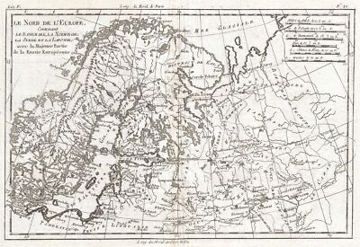
$15.00 Shipping Location: Brooklyn, United States 1780 Raynal and Bonne Map of Northern Europe and European Russia WE SELL ONLY ORIGINAL ANTIQUE MAPS- NOT REPRODUCTIONS Title: Le Nord de L'Europe. ... moreContenant Le Danemark, La Norwege; La Suede et La Laponie avec la Majeure Partie de al Russie Europeenne. Description: A fine example of Rigobert Bonne and Guillaume Raynal’s 1780 map of Northern Europe and European Russia. Covers the modern day countries of Norway. Sweden, Finland, Denmark, and Finland as well as parts of Russia(including Moscow) Poland, Lithuania, Latvia, Estonia. Highly detailed, showing towns, rivers, some topographical features and political boundaries. Drawn by R. Bonne for G. Raynal’s Atlas de Toutes les Parties Connues du Globe Terrestre, Dressé pour l'Histoire Philosophique et Politique des Établissemens et du Commerce des Européens dans les Deux Indes. Size: Printed area measures 9 inches high by 13 inches wide. Condition: Very good. Original centerfold. Platemark visible. Blank on verso. Shipping: Shipping rates are not negotiable. Items are shipped within three business days of receiving payment. We are happy to consolidate shipping where possible. The following shipping options are available: 1. USPS Domestic Express Mail(35 USD) USA Only. 2. FedEx Ground or Home Delivery(15 USD) USA Only. 1- 10 days. If your address is a P.O.Box and cannot ship FedEx we will ship USPS Priority and. While we ship promptly, recent postal personnel cutbacks mean that delivery may take up to 1 month. 3. DHL International EXPRESS(40- 50 USD) 4. We can use your Federal Express Account. Insurance: All shipments are insured privately against loss and damage. All of our shipments require a signature. If you have any questions please feel free to email us through eBay or contact us by telephone at 646-320-8650. Additional Services Conservation Framing Services: Geographicus recommends basic conservation framing services for any antique paper. Read about it here. We do not offer this service. Antique Map Restoration Services: Geographicus can
Buy It Now
$30.00 Shipping Location: Paris VI, France Then, the sons of Willem, Johan and Joan, joined him in the firm. They produced their first atlas together in 1630 the "Atlas Appendix". Five years later, ... moretheir produced their "Atlas Novus", edited in 4 languages.

Buy It Now
$15.00 Shipping Location: Brooklyn, United States 1780 Raynal and Bonne Map of Martinique. West Indies WE SELL ONLY ORIGINAL ANTIQUE MAPS- NOT REPRODUCTIONS Title: Carte de L'Isle de la Martinique ... moreColonie Francoise dans les Illes Antilles. Description: A fine example of Rigobert Bonne and Guilleme Raynal’s 1780 map of the Island of Martinique. Highly detailed. Showing towns, rivers, some topographical features, political boundaries and important ports. Mountains shown in profile. Drawn by R. Bonne for G. Raynal’s Atlas de Toutes les Parties Connues du Globe Terrestre, Dressé pour l'Histoire Philosophique et Politique des Établissemens et du Commerce des Européens dans les Deux Indes. Size: Printed area measures 13 inches high by 9 inches wide. Condition: Very good. Original centerfold. Platemark visible. Blank on verso. Shipping: Items are shipped within three business days of receiving payment. We are happy to consolidate shipping where possible. The following shipping options are available: 1. USPS Domestic Express Mail(25 USD) USA Only. 2. USPS Priority Mail(12 USD) USA Only. 3. USPS International Express(35 to 55 USD) Recommended service for all international parcels. 4. USPS Priority Mail(25 USD) Available to only certain countries. Due to high instances of loss. This service is specifically NOT AVAILABLE to MAINLAND CHINA or INDIA. 5. Federal Express is available upon request. This is the only service option available to India and Africa. Price is quoted upon request following the auction. We can also use your Federal Express Account. Insurance: All shipments are insured privately against loss and damage. All of our shipments require a signature. If you have any questions please feel free to email us through eBay or contact us by telephone at 646-320-8650. Additional Services Conservation Framing Services: Geographicus recommends basic conservation framing services for any antique paper. Read about it here. We do not offer this service. Antique Map Restoration Services: Geographicus can repair and restore your antique map. Services i
Buy It Now
$15.00 Shipping Location: Brooklyn, United States Services include deacidification cleaning flattening and backing. Signature Required.
Buy It Now
$6.00 Shipping Location: Williamsport, United States Near the beginning is Historical reports may be beautiful or ugly, but they are always informative. If you find any to be offensive, we agree! Hopefully ... morethis is an indication we are moving in the right direction.

Buy It Now
Free Shipping Location: Netherlands ABOUT US VISIT OUR STORE SALES SPECIALS Antique Print-TOURNAI-DOORNIK-BELGIUM-Coronelli-1706 Description: This scarse original old antique print/ plate ... moreoriginates from: Teatro della Guerra' by P. Coronelli. 1706. Artists and Engravers: The author of this work is Vincenzo Maria(Padre) Coronelli(1650-1718) Father Corronelli was a Franciscan priest. Who spend most of his life in Venice. He was a noted theologian and was appointed as Father General of his order in 1699. At that time he was already famous as a mathematician, cartographer and globe maker. He was very infuential, compiled and engraved over 500 maps. His most well known work is the 2-volume'Atlante Veneto' but is is equally well known for his very large terrestrial and celestial globes. One, 15 feet in diameter he made for Louis XIV of France. Subject: Plate 38: Tournay' Tournai. This plate shows the ground plan with fortifications of the Belgian city of Tournai(Doornik) Condition: Excellent. General age related toning and occasional light staining from handling. Size(in cm) The overall size is ca. 26 x 18 cm. The image size is ca. 18 x 12.5 cm. Size(in inch) The overall size is ca. 10.2 x 7.1 inch. The image size is ca. 7.1 x 4.9 inch. Medium: Etching/ engraving on vergé type hand laid paper. Location: C2-24 ThePrintsCollector Peter Cornelissen. Margo van Latum- van Dongen, Frank van Latum Zeeland- The Netherlands Phone: +31 654 21 23 78 Worldwide free shipping on all orders. We ship within one business day upon receipt of payment. We ship by Registered Mail. Insurance is included. We guarantee our items to be genuine original. Visit our Store: we would like to invite you to review similar items in our Store or to browse through all other items in our Store. We are confident that you will find very special unique antique maps and prints in our Store. It is our privilege to have you as a customer. We accept Paypal payments and payment by bank transfer. Combined auction/ buy it now orders are possible! We will send a Paypal invoice on
Buy It Now
$0.60 Shipping Location: China Yellow map with English letters, retro nostalgia. 1 Globe decoration. The map is beautifully printed and the text is clear and works fine4.Globe can be ... morerotated around, can also flip up and down, easy to read and browse5.Great for children, adults of all ages, have a good educational significance.
Buy It Now
Free Shipping Location: Fairfield, United States 🌏GREAT GIFT :- Know You Are Giving A Gift That Will Be So Appreciated Because Of It’S Amazing Character And Ability To Fit In With Any Room & Any Decor ... moreStyle. Material : Brass. Finish : Brass Antique Finish.
Buy It Now
Free Shipping Location: Netherlands Description: This scarse original old antique print / plate originates from: 'Teatro della Guerra' by P. Coronelli, 1706. Artists and Engravers: The author ... moreof this work is Vincenzo Maria (Padre) Coronelli (1650-1718): Father Corronelli was a Franciscan priest, who spend most of his life in Venice. He was a noted theologian and was appointed as Father General of his order in 1699. At that time he was already famous as a mathematician, cartographer and globe maker. He was very infuential, compiled and engraved over 500 maps. His most well known work is the 2-volume 'Atlante Veneto' but is is equally well known for his very large terrestrial and celestial globes. One, 15 feet in diameter he made for Louis XIV of France.
Buy It Now
$19.80 Shipping Location: Germantown, United States
Buy It Now
$33.00 Shipping Location: Estonia
Buy It Now
$66.34 Shipping Location: Centreville, United States The item in the pictures are the exact item you will receive. Review pictures to ensure what you are buying is what you expected.
Buy It Now
$19.80 Shipping Location: Germantown, United States All photos can be viewed via computer. What you see in the photos is what you will be getting.
4d 0h 39m 42s 0 bids
$9.99 Now
$33.65 Shipping Location: Virginia Beach, United States 12" Rand McNally Terrestrial Globe World . Shipped with USPS Ground Advantage.
Buy It Now
$19.99 Shipping Location: Sweet Grass, United States This is a very beautiful terrestrial globe made by Crams.
Buy It Now
$27.92 Shipping Location: Brooklyn, United States Very good condition.

Buy It Now
$17.45 Shipping Location: Germantown, United States We'd like to extend our gratitude to all the fine collectors on ebay-we are honored to provide you all with 5-star service and look forward to continuing ... moreto offer an always eclectic and sometimes plain weird assortment of art deco ephemera. Paper, and memorabilia in the coming year. Encyclopedia Britannica World Globe by Replogle Travel all the dark corners of the globe from your very own living room. And visit countries that no longer exist by the same names. Globe has stylish Art Deco Machine age design style. Features a wonderful silver toned chrome metal base that rotates vertically and horizontally. Measures 17" in height including stand. Globe itself is 12" in height. Fine Condition. Chrome stand and base and globe are in excellent condition and the stand rotates as manufactured with ease. A wonderful vintage table top globe-perfect gift for the map collector or want-to-be world traveler that offers a view of geo politics from the cold war era. CONDITION: In fine ++ condition with some very light roughness on the chromium base that would likely brighten up with simachrome or another metal polish and some elbow grease- that said this displays very well as seen and is in fine condition throughout inkFrog Analytics.
Buy It Now
$7.84 Shipping Location: Herndon, United States Review pictures to ensure what you are buying is what you expected. -Anything you don't see, ask if you aren't sure.
Buy It Now
$63.88 Shipping Location: Lakewood, United States Beautiful Replogle 12" reference globe by Gustav Brueckmann Cartographer in the 50-60's. Measures 18" high and is in great condition with ... moreonly the area by Hawaii that has some scratches to the print. Please email me prior to bidding as I do not accept returns on the items I sell. Paypal is accepted and I will ship within three days from receipt of payment. Payment should be made within three days from close of auction.
Buy It Now
$18.50 Shipping Location: Sigel, United States
Buy It Now
$24.95 Shipping Location: Germantown, United States What you see in the photos is what you will be getting.
Buy It Now
Free Shipping Location: Denver, United States 💡📖Built in LED lamp show you a different view at night and convenient for kids night learning. The 8" small globe also decor your desktop, bookshelf ... moreand display case. 🛫FUN TOYS & EDUCATIONAL TOOL📚:The Illuminated Wold Globe is a nice learning tool for kids and adults Geography learning.
Buy It Now
Free Shipping Location: Fairfield, United States With a weight of 1.3kg, this handcrafted piece is truly one of a kind.
Buy It Now
$23.57 Shipping Location: Philadelphia, United States A very nice Replogle 12" Starlight Globe. With black oceans. Nice condition, with some surface wear and pitting on chrome stands and rim.
Buy It Now
$55.00 Shipping Location: Ventura, United States Large 12" Solid Brass Semi Precious Gemstone Globe.
Buy It Now
Free Shipping Location: Denver, United States 💡📖Built in LED lamp show you a different view at night and convenient for kids night learning. The 8" small globe also decor your desktop, bookshelf ... moreand display case. 🛫FUN TOYS & EDUCATIONAL TOOL📚:The Illuminated Wold Globe is a nice learning tool for kids and adults Geography learning.
Buy It Now
$109.35 Shipping Location: Parma, United States
Buy It Now
Free Shipping Location: Denver, United States ◆Ares India 5" nautical functional astrolabe brass armillary sphere world globe rosewood base table decor gift ◆It was used extensively as a teaching ... moretool to explain the functioning of the solar system in Greek antiquity or could be use as a table decor and gift ◆Great product for those too who need an antique, nautical or collectible globe.
Buy It Now
$79.39 Shipping Location: Twin Falls, United States Vintage Rand McNally World Portrait Globe Raised Relief Double Axis Rotating Hello and Welcome to Treasures from Westchester. New York! Up for sale is ... morea Vintage Rand McNally World Portrait Globe Very nice vintage world portrait globe 12" movable by hand Researched to circa 1960's. North and South Vietnam Item is in relief. Has metal base and is on axis Does not stand diagonal as most. Spins flat(horizontally) but can be moved by hand to any incline Condition appears very good T hank you for shopping with us and feel free to email any questions. Combined shipping is available for multiple purchases. Please don't forget to visit my store as I am in the process of putting on Furs. Jewelry, Mid Century Modern and Vintage Houseware items that I have found in the N.Y. and Connecticut areas!

Buy It Now
Free Shipping Location: Training Battalian S.O, India Vintage Brass Zodiac Tabletop Armillary Nautical Sphere Globe Sundial Angel Top. Good vintage pre-owned condition. Nice decor item. Some green tarnishing. ... moreBeautiful piece. 13" tall. Nice decor item, beautiful look. Please see all pictures for the very best description. Thanks for looking! Please see my store for all kinds of vintage and unique items. Something for everyone. Items: All items I like to call treasures. I go in search of these items at any sale I can find. All items are used, pre-owned, pre-loved, or pre-USED, and I am NOT an expert on anything I sell. I try to describe all items as accurately and honestly as possible, HOWEVER PICTURES ARE THE BEST PART OF THE DESCRIPTION. My idea of great may be different than yours, so PLEASE use all pictures as the best part of the description. Due to the fact that all these items are vintage and or pre-owned they are AS IS. Most items will need a detail cleaning. I wipe all items down. But leave the fine cleaning to you. Shipping: I do my best to calculate the correct shipping cost. I do combine shipping. And will figure the exact cost to ship the items to you. If you are overcharged more than $1.00 I will refund the difference. I will send you an invoice with the correct amount. I ship almost daily, and mail by 1 pm. I do my best to send your purchase 1 day after payment. Payments: I accept PAYPAL. Other payment forms may be accepted. Please e-mail first. All payments must be made in within 5 days of auction ending, or just let me know. I am easy to work with. I use EBAY Unpaid manager after 5 days. Feedback: I am an honest seller. Try to describe every item best as I can. If you are not completely satisfied PLEASE contact me prior to leaving feedback. I am easy to work with, I will make things right. I work hard to make sure your experience is a GREAT one, if for some reason it is not please just e-mail me! I will leave POSITIVE feedback, when you pay. I strive for EXCELLENT CUSTOMER SERVICE, and will package your items will great care! Returns: I accep
Buy It Now
$24.00 Shipping Location: Training Battalian S.O, India Our Globe has up to date detail, encourage inquisitive children to explore the world of science with their own hands and eyes. Children may be able to ... moreexplore the continents they have or have not been, spot a place and find out what’s on it, and what’s around it, they would be encouraged to read and recognize the fact of the earth geographically and historically.

Buy It Now
Free Shipping Location: Training Battalian S.O, India Armillary Sphere on Wood Base New in Box mouseover to enlarge Armillary Sphere on Wood Base 7" x 7" x 11.5" This is a replica of an European ... moreDemionstrational Armillary Sphere. It was used to measure the relationships of the objects in the sky. Each piece is made of finely crafted brass. It consists of a set of graduated rings representing circles on the celestial sphere. The brass sphere at the center of the armillary represents the Earth. The rims are marked"A PARIS Chez G. Gobille a P Ache Royalle. It features a rich antique finish that does not tarnish or show fingerprints. The heavy solid brass base is mounted on turned solid hardwood and the bottom is covered with felt. History Armillary spheres have become an icon of science with their elegant rings and beautiful silhouettes. Eratosthenes may have invented armillary spheres around 255 BC. These instruments are made up of a set of graduated rings representing circles on the celestial sphere. Such as the meridian, equator, ecliptic horizon, tropics, and colures. With the aid of an armillary sphere, one can track the path of the sun for any given day of the year or determine a stars coordinates. The earth is represented by the brass sphere located at the center of the armillary sphere. Free shipping is for the continental 48 United States only. This product will make a perfect gift for the home or office decorator. Historian or passionate collector. LeeAnn's Treasures is proud of our feedback score. We try hard to maintain 100% in our feedback score and to maintain a 5-star rating. Anything less than 5 stars means we have failed you. If you have a problem with our products or service. Please let us know so we can work it out with you before you leave a"less than 5 star" rating. 100% satisfaction is guaranteed! for more great items! We accept PayPal for our auctions. Our large items are shipped by FedEx or UPS. Oversize items will be shipped by common carrier. Therefore. We need a physical address. We cannot deliver to a P.O. B
Buy It Now
Free Shipping Location: Training Battalian S.O, India The brass sphere at the center of the armillary represents the Earth. Size: 9" H x 4.5" D (base) x 5.5" D (sphere). Size: 5" H x 3.5" D (base) x 3.5" ... moreD (sphere). Base solid wood. Felt underneath.
Buy It Now
$6.00 Shipping Location: Potomac, United States Sept. 7, 1702. solo indvsio tectae et faces accensas manibus praeferentes in basilica hispalensi se voto exsolverunt vii sept, ann.ndxxii Munich. But ... morethere might be a deeper and more important reason: Heinrich Scherer was a Jesuit and hisweltanschauung was shaped by Jesuit ideas and doctrines.
Buy It Now
Location: Woodinville, United States Atlas is made from bronze resin. Looks like possible wear to Ethiopia but could be coloration of the mountain ranges as well?. Condition: Pre-Owned Good.
Buy It Now
$3.90 Shipping Location: China Yellow map with English letters, retro nostalgia. 1 Globe decoration. The map is beautifully printed and the text is clear and works fine4.Globe can be ... morerotated around, can also flip up and down, easy to read and browse5.Great for children, adults of all ages, have a good educational significance.
Buy It Now
$0.97 Shipping Location: China Yellow map with English letters, retro nostalgia. 1 Globe decoration. The map is beautifully printed and the text is clear and works fine4.Globe can be ... morerotated around, can also flip up and down, easy to read and browse5.Great for children, adults of all ages, have a good educational significance.
Buy It Now
$0.60 Shipping Location: China Yellow map with English letters, retro nostalgia. 1 Globe decoration. The map is beautifully printed and the text is clear and works fine4.Globe can be ... morerotated around, can also flip up and down, easy to read and browse5.Great for children, adults of all ages, have a good educational significance.
Buy It Now
Free Shipping Location: China Yellow map with English letters, retro nostalgia. 1 Globe decoration. The map is beautifully printed and the text is clear and works fine4.Globe can be ... morerotated around, can also flip up and down, easy to read and browse5.Great for children, adults of all ages, have a good educational significance.
|
|
|
|