|
|
Order by: Available to: This site contains affiliate links for which I may be compensated
|
Buy It Now
$10.00 Shipping Location: GLASGOW, United Kingdom We do not deal in facsimiles or reproductions of any kind. We grade all prints individually into four levels - Excellent, Very Good, Good, and Fair. Good ... moreand fair may have more general foxing. We try to represent all the images to the best of our ability, and we ask you to check the above scans before purchasing.
Buy It Now
$6.00 Shipping Location: North Wales, United States 1900 ANTIQUE MCNALLY PUBLIC LEDGER UNRIVALED ATLAS MAP-WASHINGTON-UNITED STATES ORIGINAL ATLAS MAP PLEASE SEE PHOTOS AS PART OF THE DESCRIPTION CONDITION: ... moreMAP IS IN GOOD CONDITION. APPROXIMATELY 11" X 14" SHIPPING: U.S. FIRST CLASS RATE - $7.00 - ANY ITEM WHICH SELLS FOR OVER $100 WILL REQUIRE INSURANCE WE COMBINE SHIPPING FOR MULTIPLE WINS. THANK YOU FOR YOUR INTEREST IN OUR AUCTIONS!.
Buy It Now
$13.77 Shipping Location: MANCHESTER, United Kingdom This large map is from The Comprehensive Atlas of Modern Geography by W.G. Blackie, published by Blackie and Son, London, 1884. This interesting map is ... morean original antique which is over 135 years old.
Buy It Now
$13.77 Shipping Location: MANCHESTER, United Kingdom This original antiquemap is from The Weekly Dispatch published in London in 1863. The mapmakers included Edward Weller, John Dower, R.R. Davies and J.W. ... moreLowry. This interesting map is an original antique which is over 160years old.
Buy It Now
$9.98 Shipping Location: Wind Gap, United States Condition is "Used" and may show wear and signs of use.
Buy It Now
$6.95 Shipping Location: Dover, United States Issued 1875, New York by F.W. Beers. Very detailed mid-19th century color lithographed map. Of great interest for historical genealogical purposes.
Buy It Now
$3.50 Shipping Location: Dover, United States Dover Quadrangle Missouri 7.5 Minute Series. Places: Dover. Year Published: 1951. Edition Year: 1951.
Buy It Now
$6.65 Shipping Location: Celina, United States Just the map pictures is included the other map is missing, this book has pages 1-91 and the map pictured, binding is gone it is in a makeshift binded ... morebook
Buy It Now
$6.95 Shipping Location: Dover, United States Ayer Junction. Issued 1875, New York by F.W. Beers. Very detailed mid-19th century lithographed map with original hand color. Of great interest for historical ... moregenealogical purposes. Map identifies property lines, churches, schools, etc.
Buy It Now
$3.50 Shipping Location: Dover, United States Places: Springfield, Claremont, Ascutney, Windsor, Unity. Year Published: 1960. The map in the photo is the actual map you will receive.
Buy It Now
$6.00 Shipping Location: North Wales, United States 1908 RARE ANTIQUE MCNALLY ATLAS MAP-VERMONT-UNITED STATES-EXCELLENT DETAIL ORIGINAL ATLAS MAP PLEASE SEE PHOTOS AS PART OF THE DESCRIPTION CONDITION: ... moreMAP IS IN GOOD CONDITION. APPROXIMATELY 11" X 14" SHIPPING: U.S. FIRST CLASS RATE - $7.00 - ANY ITEM WHICH SELLS FOR OVER $100 WILL REQUIRE INSURANCE WE COMBINE SHIPPING FOR MULTIPLE WINS. THANK YOU FOR YOUR INTEREST IN OUR AUCTIONS!.
Buy It Now
$45.00 Shipping Location: El Dorado, United States This is from the rare 1877 Stieler Hand Atlas, published in Germany by Justus Perthes.
Buy It Now
Free Shipping Location: Monroeville, United States Source - Illustrated Historical Atlas of Clinton County, Ohio. Date - 1876. Size - about 13.75x16.25".
Buy It Now
$11.66 Shipping Location: Latvia Antique map "NORTH AMERICA. USA. WESTERN STATES". Circa 1880. Sheet size - 30,8 x 24,6 cm. Image size - 28,4 x 21,7 cm. The other side - clear. Source ... more- Brockhaus Konversations Lexikon, 13.Auflage. Condition - Please check attached photogrphy and scanned images. Combined postage available!!! Shipping - WORLDWIDE Attention German buyers!!! Since my activity has been restricted by German Ebay, please contact me privately, you can find my contact information in the last picture of each ad
Buy It Now
$8.30 Shipping Location: Celina, United States See pictures, in good condition
Buy It Now
$8.70 Shipping Location: Manassas, United States essex saybrook deepriver 1874 map F.W. Beers. 16”x13”
Buy It Now
$3.50 Shipping Location: Dover, United States Wittenberg Quadrangle Wisconsin- 15 Minute Series. Places: Elderon, Wittenberg, Eland, Birnamwood, Almon. Year Published: 1965. The map in the photo is ... morethe actual map you will receive.
Buy It Now
$6.00 Shipping Location: North Wales, United States 1897 RARE ANTIQUE CENTURY ATLAS MAP-PENNSYLVANIA-EASTERN PART-EXCELLENT DETAIL ORIGINAL ANTIQUE ATLAS MAP PLEASE SEE PHOTOS AS PART OF THE DESCRIPTION ... moreCONDITION: MAP IS IN GOOD CONDITION. SIZE: APPROXIMATELY 10.5" X 15" SHIPPING: U.S. FIRST CLASS RATE - $6.00 - ANY ITEM WHICH SELLS FOR OVER $100 WILL REQUIRE INSURANCE WE COMBINE SHIPPING FOR MULTIPLE WINS. THANK YOU FOR YOUR INTEREST IN OUR AUCTIONS!.
Buy It Now
$4.99 Shipping Location: Port Jefferson Station, United States 1847 D.F. Robinson Antique Map Olney School Atlas USA Western Territories Oregon. Map is in good condition for its age. Minor stain on map near Saint ... moreHelena. Minor soiling on outside of map and a few tears on edges.. see pics 12” x 8 1/2”
Buy It Now
$11.85 Shipping Location: Dover, United States Issued 1792, London by Trusler. Engraved by Neele. Map of the City of Quebec. Late 18th century engraved map with attractive hand color. Numbered & lettered ... morekey identifies major city locations.
Buy It Now
$3.65 Shipping Location: United States FREE scheduling, supersized images.
Buy It Now
Free Shipping Location: Augusta, United States "An Authentic Original Map Not A Reproduction".
Buy It Now
$3.50 Shipping Location: Dover, United States Jefferson Quadrangle Maine 7.5 Minute Series. Places: Jefferson. The map in the photo is the actual map you will receive. Year Published: 1983.
Buy It Now
$3.50 Shipping Location: Dover, United States Year Published: 1967. The map in the photo is the actual map you will receive.
Buy It Now
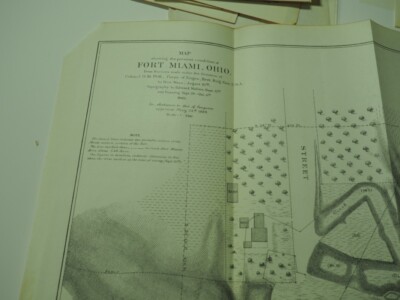
$5.50 Shipping Location: Easton, United States 1938 Road Map MAUMEE HOLLAND WATERVILLE Lucas County Ohio Fort Miami Perrysburg Genuine original lithographed topographical map of part of Lucas and Wood ... morecounties in northwestern Ohio. Printed more than 75 years ago. This map has excellent detail. Including roads, schools, churches, cemeteries, railroads, and natural features. It even locates individual houses and farms! The coverage area extends from Waterville to Holland, east to Perrysburg. It was published by the United States Geological Survey and is identified as the 1938 edition of the Maumee quadrangle. Bounded by longitude 83°37' 30" W to 83°45' W and latitude 41°30' N to 41°37' 30" N. Among the specific named places and features are the Heather Downs Country Club. Blue Grass Island, the Baltimore& Ohio Railroad, Roachton Road, Fort Meigs, Monclova, the Miami& Erie Canal, Sylvania Road, the New York, Chicago& St. Louis Railroad, Homewood, Fort Miami Fair Grounds, Ewing Island, the Wabash Railroad, Glendale School, Keener Ditch, Hulls Crossing, Spring Valley, and more. The map is drawn on a scale of 1:31.680, with contour lines at 5-foot intervals, and is based on surveys conducted in 1934 and 1936. The image area measures 17-1/4" x 13" on a larger sheet, with generous margins on all sides. The scans below give a closer look at some of the detail: Condition: This is an ex-library map in very good. Lightly used condition, with an old library stamp in the right margin. A previous owner has written a number in the upper corner, outside of the image area. This is an original. Authentic 1938 map, not a reproduction or modern reprint. And it is fully guaranteed to be genuine. Early maps are often the only record we have of how a particular place"looked" at a given point in its history. And this offers a view back at this historic part of the Buckeye State as it was early in the last century. The map would make a handsome display in your den or office. It would also make a perfect gift
Buy It Now
$3.25 Shipping Location: Enterprise, United States Blank on reverse. I pride myself in providing optimal protection. - Perfect smaller size for framing as gift.
Buy It Now
$3.50 Shipping Location: Dover, United States Sharon Quadrangle Connecticut- 7.5 Minute Series. Places: Lakeville, Sharon, Salisbury. Year Published: 1971. The map in the photo is the actual map you ... morewill receive.
Buy It Now
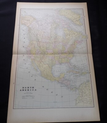
Free Shipping Location: Monroeville, United States Home ~ Affiliations ~ Discounts ~ FAQs ~ Grading and Certification ~ Premium Shipping ~ About Us VINTAGE ART 1890 Print Map North America United States ... moreDominion Canada Mexico Alaska Jamaica Details Year: 1890 Type: Relief Line-block Map Grade: Very Fine ++ Authentication: Dual Certificates Image: Color Approximate Size(inches) 13.5 x 20.5 Approximate Size(cm) 34 x 52 Description and Condition This is an original 1890 color relief line-block map of North America. CONDITION This 121+ year old Item is rated Very Fine ++. Light wrinkling. Tightly cropped- left margin. No surface rub. Small tear. No water damage. Please note: There are five intersecting creases as a result of the original publication folding. To find other items from this specific collection in our eBay store. Please. Keywords specific to this image: Dominica. San Juan, Honduras, Nicaragua, Yucatan, Greenland, Labrador, Guatemala, Cuba, South America, Central America, Gulf of Mexico, Atlantic Ocean, Pacific Ocean, Baffin Island, Rupert's land, Nova Scotia, New York, Florida, California, Wisconsin, Ohio, Texas, Tennessee, Wyoming, Hudson Bay, Arctic Ocean. XGLC7C90 Product Pricing& What We Deliver At times we receive inquiries about our pricing. Especially for vintage advertising or historical halftone prints, and are asked why our prices are consistently higher than some other sellers of similar items. For the first five years of our business, we asked our primary consumer base what they wanted. Our primary consumers- historical societies, historians, archivists, curators, university professors, historical decorators, and collectors, etc. have diverse and specific needs and we've built our business to accommodate those needs, like no other seller worldwide. Below is what is unique about how and what we offer as the world's leader in print ephemera: Product Packaging. Every product is placed against custom black acid-free board with crystal-clear. Archival protective closures. We are the only sellers in the industry who provide display-
Buy It Now
$3.50 Shipping Location: Dover, United States Tamms Quadrangle Illinois 7.5 Minute Series. Places: Tamms, Olive Branch. The map in the photo is the actual map you will receive. Year Published: 1968.
Buy It Now
$6.00 Shipping Location: North Wales, United States 1872 ANTIQUE MITCHELL ATLAS MAP OF NEW JERSEY, MARYLAND, DELAWARE-UNITED STATES ORIGINAL ANTIQUE ATLAS MAP PLEASE SEE PHOTOS AS PART OF THE DESCRIPTION ... moreCONDITION: MAP IS IN GOOD CONDITION. SIZE: APPROXIMATELY 12" X 15" SHIPPING: U.S. FIRST CLASS RATE - $6.00 - ANY ITEM WHICH SELLS FOR OVER $100 WILL REQUIRE INSURANCE WE COMBINE SHIPPING FOR MULTIPLE WINS. THANK YOU FOR YOUR INTEREST IN OUR AUCTIONS!.
Buy It Now
$3.50 Shipping Location: Dover, United States Collinston Quadrangle Louisiana- 15 Minute Series. Places: Swartz, Collinston, Oak Ridge, Jonesburg. Year Published: 1958. The map in the photo is the ... moreactual map you will receive.

Buy It Now
Free Shipping Location: Orlando, United States Click Here. Double your traffic. Get Vendio Gallery- Now FREE! Huge. Very fine, antique 1922 color lithographed maps, superb set of 7 amazing large period ... moremaps, they are: South Pacific Ocean, South Australia, Eastern Queensland, New South Wales, Australia Western and Eastern Section, and Australia Political Map. The colors on the map are gorgeous, very vivid and attractive. The map is very finely printed on thick paper, superb period color lithography, no printing on reverse, and in excellent conditon, the map would frame and display quite nicely. The map is large, detailed and attractive, amazing period map. Printed at bottom is The Edinburgh Geographical Institute and John Bartholomew& Son, Ltd. This is from the famous and rare 1922 The Time Atlas of the World. Fascianting, detailed period map. Gorgeous map. The size of each map is 18" by 23" Rare. Winning bidder pays $6.00 shipping domestic, more foreign. Payment I accept the following forms of payment: PayPal Click to View Image Album Click to View Image Album Click to View Image Album Click to View Image Album Click to View Image Album Click to View Image Album Click to View Image Album Shipping& Handling US Shipping. $6.00 USPS First-Class Mail® International Shipping. $10.00 USPS First-Class Mail International FREE scheduling. Supersized images and templates. Get Vendio Sales Manager. FREE scheduling. Supersized images and templates. Get Vendio Sales Manager.
Buy It Now
$4.50 Shipping Location: Slingerlands, United States This is an Army Map Service map Peeksville New York showing the Hudson river from Verplanck to Highland Falls including Camp Smith. The Naval Reservation ... moreand part of West Point. These maps were developed as part of the war effort and were distributed to libraries after the war. This map is near perfect, no yellowing, tears or folds and is suitable for framing. Guaranteed original. 22x29" 1:25,000 This is from a library collection. If you would like a map of NY not listed. Contact me and I will list it. Shipping is for US addresses and I will combine shipping.
Buy It Now
$6.95 Shipping Location: Atlanta, United States I will list if I have them. Macon County, Dooly County, Five Points, Spalding, Horsehead Creek. It DOES NOT have an institutional ink stamp. The map in ... morethe photo is the actual map you will receive.
Buy It Now
$4.13 Shipping Location: Nashville, United States Up for sale is an original antique 1883 map of MADAGASCAR & SOUTHEAST ASIA. Removed from an antique 1883 Alden’s Atlas. Map would make a wonderful gift. ... moreI REALLY TRY MY BEST TO BE A NICE, COURTEOUS PERSON AND WILL GLADLY WORK WITH YOU ANYWAY I CAN.
Buy It Now
$3.50 Shipping Location: Dover, United States Ormas Quadrangle Indiana- 7.5 Minute Series. Year Published: 1952. The map in the photo is the actual map you will receive.
Buy It Now
$3.50 Shipping Location: Dover, United States Water Bodies: Bear Creek, Brady Creek, Brady Reservoir, Reservoir Number Four. Brady SW Quadrangle Texas 7.5 Minute Series. Year Published: 1964.
Buy It Now
$3.50 Shipping Location: Dover, United States Hotchkiss Quadrangle Colorado- 7.5 Minute Series. Places: Hotchkiss. The map in the photo is the actual map you will receive. Year Published: 1980.
Buy It Now
$4.00 Shipping Location: Freeport, United States P. 28 & 29.
Buy It Now
$3.50 Shipping Location: Dover, United States Water Bodies: Big Otter River, Buffalo Creek, Elk Creek, Old Elkton Lake, Poplar Forest Lake, Timber Lake. Forest Quadrangle Virginia- 7.5 Minute Series. ... morePlaces: Forest, Timberlake. Year Published: 1967.
Buy It Now
Free Shipping Location: Dover, United States Cando Quadrangle North Dakota- 7.5 Minute Series. Places: Cando, Maza. Year Published: 1958.
Buy It Now
$3.15 Shipping Location: Enterprise, United States Showing Acquisition of Territory. A 1907 Map Print. The Nature of Prints & Engravings : It was not until the 20th century that prints were commonly produced ... morefor the print itself. Prior to this, virtually all prints (and engravings) were produced as illustrations to be included in a manuscript, book, newspaper, or pamphlet.
Buy It Now
$5.50 Shipping Location: Easton, United States "Plan of Racine Harbor October 1853". Map is folded.
Buy It Now
$6.00 Shipping Location: North Wales, United States 1897 RARE ANTIQUE CENTURY ATLAS MAP-MISSOURI-NORTHERN PART-EXCELLENT DETAIL ORIGINAL ANTIQUE ATLAS MAP PLEASE SEE PHOTOS AS PART OF THE DESCRIPTION CONDITION: ... moreMAP IS IN GOOD CONDITION. SIZE: APPROXIMATELY 10.5" X 15" SHIPPING: U.S. FIRST CLASS RATE - $6.00 - ANY ITEM WHICH SELLS FOR OVER $100 WILL REQUIRE INSURANCE WE COMBINE SHIPPING FOR MULTIPLE WINS. THANK YOU FOR YOUR INTEREST IN OUR AUCTIONS!.
Buy It Now
Free Shipping Location: Schertz, United States The map is not " new " or in " new " condition & was printed in 1897. It is not dated.
Buy It Now
$3.50 Shipping Location: Dover, United States Concordia Quadrangle Kansas 7.5 Minute Series. Places: Concordia. Year Published: 1966. The map in the photo is the actual map you will receive.
Buy It Now
$3.50 Shipping Location: Dover, United States Kreole Quadrangle Mississippi-Alabama 7.5 Minute Series. Places: Helena, Kreole. The map in the photo is the actual map you will receive. Year Published: ... more1978.
Buy It Now
$4.50 Shipping Location: Minneapolis, United States May have yellowing and/or other discoloration on or near edges, small tears, creasing and/or wrinkles. There may be writing on back of map which might ... moreshow through on the front upper right corner. May have stamp mark.
Buy It Now
$3.50 Shipping Location: Dover, United States Magee North Quadrangle Mississippi 7.5 Minute Series. The map in the photo is the actual map you will receive. Year Published: 1978.
Buy It Now
Free Shipping Location: Schertz, United States This Pictorial Map is in very good condition. The image is approx. 3 1/4 x 4 3/4. The map is not " new " or in " new " condition, it was printed in the ... more1929. The map is not dated. Study the photos carefully, this is the actual map you will receive.
Buy It Now
$7.00 Shipping Location: North Wales, United States 1899 ANTIQUE PEERLESS ATLAS MAP OF MARYLAND & DELAWARE-UNITED STATES ORIGINAL ANTIQUE ATLAS MAP PLEASE SEE PHOTOS AS PART OF THE DESCRIPTION CONDITION: ... moreMAP IS IN GOOD CONDITION. SIZE: APPROXIMATELY 10" X 13" SHIPPING: U.S. FIRST CLASS RATE - $7.00 - ANY ITEM WHICH SELLS FOR OVER $100 WILL REQUIRE INSURANCE WE COMBINE SHIPPING FOR MULTIPLE WINS. THANK YOU FOR YOUR INTEREST IN OUR AUCTIONS!.
Buy It Now
$6.50 Shipping Location: North Wales, United States 1859 ANTIQUE CORNELL ATLAS MAP OF NINE OF THE WESTERN STATES-UNITED STATES ORIGINAL ANTIQUE ATLAS MAP PLEASE SEE PHOTOS AS PART OF THE DESCRIPTION CONDITION: ... moreMAP IS IN GOOD CONDITION. SIZE: APPROXIMATELY 6.5" X 8.5" SHIPPING: U.S. FIRST CLASS RATE - $6.00 - ANY ITEM WHICH SELLS FOR OVER $100 WILL REQUIRE INSURANCE WE COMBINE SHIPPING FOR MULTIPLE WINS. THANK YOU FOR YOUR INTEREST IN OUR AUCTIONS!.
Buy It Now
$6.00 Shipping Location: North Wales, United States 1893 ANTIQUE SURVEY MAP-DAM AT GREAT FALLS, MARYLAND-SOCIETY OF CIVIL ENGINEERS ORIGINAL ANTIQUE ATLAS MAP PLEASE SEE PHOTOS AS PART OF THE DESCRIPTION ... moreCONDITION: MAP IS IN GOOD CONDITION. FOXING PRESENT. SIZE: APPROXIMATELY 6" X 6.5" SHIPPING: U.S. FIRST CLASS RATE - $6.00 - ANY ITEM WHICH SELLS FOR OVER $100 WILL REQUIRE INSURANCE WE COMBINE SHIPPING FOR MULTIPLE WINS. THANK YOU FOR YOUR INTEREST IN OUR AUCTIONS!.
Buy It Now
$7.00 Shipping Location: North Wales, United States 1870 ANTIQUE TITUS ATLAS OF CLARKE COUNTY OHIO-MAP OF GREEN TOWNSHIP ORIGINAL ANTIQUE ATLAS MAP PLEASE SEE PHOTOS AS PART OF THE DESCRIPTION CONDITION: ... moreMAP IS IN GOOD CONDITION. SIZE: APPROXIMATELY 10" X 13" SHIPPING: U.S. FIRST CLASS RATE - $7.00 - ANY ITEM WHICH SELLS FOR OVER $100 WILL REQUIRE INSURANCE WE COMBINE SHIPPING FOR MULTIPLE WINS. THANK YOU FOR YOUR INTEREST IN OUR AUCTIONS!.
Buy It Now
$10.00 Shipping Location: GLASGOW, United Kingdom We do not deal in facsimiles or reproductions of any kind.

Buy It Now
$10.00 Shipping Location: GLASGOW, United Kingdom NORTH AMERICA Canada. Vereinigte Staaten(USA) Mexico- Antique Stieler Map 1891 Print Description: NORTH AMERICA Canada. Vereinigte Staaten(USA) Mexico- ... moreAntique Stieler Map 1891 Size: The Size of the print/map not including margins is approximately 16x13 inches. Cartographer: By H Habenicht and H Salzmann. Provenance: Taken from Stielers Hand Atlas. Published by Justus Perthes geographical institute in Gotha 1891 Authenticity: This is a guaranteed genuine antique print. We do not deal in facsimiles or reproductions of any kind. Condition: Very Good; Suitable for framing. We grade all prints individually into four levels- Excellent. Very Good, Good, and Fair. Generally prints in excellent condition are free from foxing, rips,tears or folds. Very Good prints may have some minor foxing or spotting, however this will mainly be confined to the margins. Good and fair may have more general foxing. We try to represent all the images to the best of our ability, and we ask you to check the above scans before purchasing Payment: PayPal is our only accepted method of payment. We accept PayPal payments from buyers all over the world. PayPal is the safest. Easiest and quickest way to make online purchases. If you are purchasing multiple items, please add all the items to your shopping basket before proceeding to the checkout. If you do not already have a PayPal account, simply click on the'Buy It Now' button and follow the eBay checkout instructions. You will then be able to enter your card details in order to pay via PayPal even if you do not already have a PayPal account. Paying via PayPal also ensures that your purchase is fully protected and guaranteed. Returns Policy: If for any reason you are not satisfied with your order we will gladly accept a return for refund or credit. If you wish to return goods you MUST inform us within 14 days of receipt of your order. Please do not return goods without prior consent. All returns must be received in perfect re-saleable condition in order for refunds to be granted. If the
Buy It Now
$6.00 Shipping Location: North Wales, United States 1893 ANTIQUE CRAM'S UNRIVALED ATLAS MAP-TERRITORIAL GROWTH OF THE UNITED STATES ORIGINAL ANTIQUE ATLAS MAP PLEASE SEE PHOTOS AS PART OF THE DESCRIPTION ... moreCONDITION: MAP IS IN GOOD CONDITION SIZE: APPROXIMATELY 11" X 14" SHIPPING: U.S. FIRST CLASS RATE - $7.00. CANADA - $20.00. WORLDWIDE - $25.00 ANY ITEM WHICH SELLS FOR OVER $100 WILL REQUIRE INSURANCE. WE COMBINE SHIPPING FOR MULTIPLE WINS. THANK YOU FOR YOUR INTEREST IN OUR AUCTIONS!.

Buy It Now
Free Shipping Location: Orlando, United States 1957 Waterville. Maine, US Geological Survey Topographic Map Mapped. Edited and Published by the USGS Topography by plane table surveys in 1941 and revised ... morein 1956-1957 Scale 1:62.500 Contour Interval = 20 feet Features shown Cities. Towns and Villages: Oakland. Waterville, Hayden Corner, Paines Corner, Lambs Corner, East Winslow, Benton, Benton Falls, Fairfield, Fairfield Center, Benton Station, Clinton, Morrison Corner, Hinckley, Pishon Ferry, Larone, North Fairfield, Shawmut and several other communities. Counties: Somerset. Kennebec Rivers and Lakes: Kennebec River. Sebasticook River, Pattee Pond, Messalonskee Lake and several other streams, brooks and swamps Railroads: Maine Central RR Roads: US 201; SR 11. 100, 139, 32, 23, 104; Clinton Ave. Ridge Road, Hill Road and several other named roads and many other unnamed roads Geologic Features: Baker Hill. Town House Hill, Canaan Bog, Bigelow Hill, Brooks Ridge, Horn Hill, Hussey Hill, Wilcox Hill, Mayflower Hill, Eaton Ridge, Schools. Churches and other points of interest: Waterville Airport( La Fleur Field) Mt Merci Academy, Colby College, Drummond Cemetery, McClintock Cemetery, Camp Caribou, Wilson Cemetery, Brown Cemetery, Holt Cemetery, Emery Hill Cemetery, Central Maine Sanatorium, Ames Cemetery, Maplewood Cemetery, Thayer Hospital, Lakeview Cemetery, Pine Grove Cemetery, Country Club, Ten Lots Chapel, Pooler Cemetery, Hilton Bridge, Saul Cemetery, Joy Cemetery, Good Will Homes, Ferry School, Morrison School, several gravel pits, several radio towers and a few other named and unnamed cemeteries Adjacent Maps available on EBay: Anson(n/a) Skowegan(n/a) Pittsfield(n/a) Burnham(n/a) Liberty(n/a) Vassalboro(n/a) Augusta(n/a) Norridgewock(n/a) n/a = not available Please check my store. Dave’s Maps and More for more California, Colorado, Delaware, Georgia, Indiana, New Jersey, New York, Ohio, Oregon, Pennsylvania, Texas, Virginia, Washington, West Virginia, Wisconsin topographic maps as well as many other highway maps, tools and knives. This
Buy It Now
$8.70 Shipping Location: Encinitas, United States Excellent condition copper plating map. One small foxing spot. Full margins. Prior under glass with matting. I have no doubt on authenticity originality ... moreof this map based on extensive research. Size 15" x 12.5".
Buy It Now
$6.95 Shipping Location: Dover, United States Issued 1858, Philadelphia by S. Augustus Mitchell. Mid 19th century antique engraved map with original hand color. Map of the State of Texas.
|
|
|
|
RARE 1860s Central Park NY 11th Annual Report Antique Maps 4' Great for Framing
RARE 1860s Central Park NY 11th Annual Report Antique Maps 4' Great for Framing- this is a rare 11th annual report of the board of commissioners of the central park in new york. Unfortunately the book has seen better days. The cover is detached and the binding is paper is gone showing some of the individual wraps of the page groupings and not holding them together the best as well as writing on the cover. Few within pages and edge nicks, chips and tears, dirt, discolorations etc here and there throughout the covers and pages. however all of the maps are present and other than some edge or corner tears or slits and some slit tears at the inner seams were protected from being within the book. I have seen some of the central park maps from 1860s go for a quite a bit taken out individually and framed. The map at the front of the book is about ... more39x16" and semi circle torn out upper right corner and some pencil writing on the backside area of teh map. There are 4 pull out maps in total. The middle two are much smaller. The large map at the back of the book has some tears and wear where is attached to the book and seam split tears on some of the insides/ corners/ intersections of the fold lines and seams and measures about a whopping 50x17" Please see photos for best judge of actual condition and content. Powered by The free listing tool. List your items fast and easy and manage your active items.
|
|
|
OLD VINTAGE ANTIQUE COLUMBIAN WORLD'S FAIR ATLAS COLOR MAPS
OLD VINTAGE ANTIQUE COLUMBIAN WORLD'S FAIR ATLAS COLOR MAPS Item Description. I have for sale this early antique antique from the Columbian World's Fair. Has about 100 maps. Maps measure about 12" x 13" About the first half of the book has information on the fair and the last part is the maps. The covers are a little bit loose but attached. Spine looks okay. The first page which is blank has a tear. The inside maps are yellow around the edges Thanks. Click any image to see it full size. Payment Details. Please pay with paypal.com. Shipping Details. Please add $7.99 shipping to 50 states only. International bidders please use the shipping calculator. The calculator for Russia is not working properly. Buyers from the Russian Federation please email me for a quote. Thank you. Additional Information. 3.10. at BiggerBids.com.
|
|
|
1864 Johnson's Family Atlas Civil War US & World Antique Maps Complete
1864 Johnson's Family Atlas Civil War US& World Hand Colored Maps Complete You will be bidding on an 1864 Johnson's New Illustrated(steel plate) Family Atlas with Chronological History of the Civil War with US& World Hand Colored Maps. Complete. 63+ hand colored plates& maps from around the world in good condition overall published by Johnson& Ward. Spine is loose and splitting as shown in the images. Roughly 13 maps have small tears on the edges from people not turning the pages correctly. The New York State and Indiana maps have larger tears at the seam but they are clean tears and can be fitted rather easily if removed from the book. The paper is not too brittle yet as most volumes of these books are and the maps are in nice condition for the person who might want to remove the maps for framing and preservation. ... moreWith over 63 plates at $25 a plate average, there is plenty of money left in this book for the map reseller. For the collector, I would suggest having it restored. Either way this extremely large atlas would make a very nice addition to your collection. I am not a book expert so please ask questions so I can answer them before the auction ends. I can send more pictures upon request as well and I thank you for looking I gladly combine shipping! Please view the other Collectible items I have for sale now on Ebay at the link below. Check out my other items! A small fee for shipping materials is included in the calculated shipping/handling charge. Shipping/Handling is paid by buyer. I accept Paypal. International bidders are welcome but please request a shipping quote from me before bidding. Questions are always welcome and Please bid with confidence! My Policies: Another auction from Antiques Advisors. Powered by
|
|
|
Antique and Decorative Maps and Charts Catalogue 959 Francis Edwards London UK
Title/Info: Antique and Decorative Maps and Charts Catalogue 959 Francis Edwards London UK. Stapled binding. 20 pages. Additional Info: Exactly the same as pictured. Light creasing to corners of covers. Bumped corners. Edge wear. ch15. Misc 16) Shipping is FREE to the United States! Shipping worldwide will be additional. Depending on the size of the additional volumes. 2-3 volumes can usually ship at the same initial shipping price. 4-5 items at this shipping rate can ship in a USPS Flat Rate Priority Mail Envelope. Please request an invoice for multiple purchases before paying via Paypal. Powered by
|
|
|
c1897 Rand McNally's New Orleans and Louisiana (2 maps) Original Antique Maps
SEE ALL MY ITEMS: EBAY ADVANCE SEARCH. SELLER, mapseller01 Terms: Domestic and Overseas shipping as per prices listed on bid details. Please note: No refunds on overseas items sent without tracking. We ship within 48 hours of receipt of funds. Any questions. Please email or you can call: The Map Seller 1-858-571-2031. We only sell maps. Prints and books relating to cartography. We answer all questions in a timely manner. No reproductions unless clearly stated Additional cartographic materials available at PS Maps.
|
|
|
Antique Maps of Hanoi & Saigon by John Bartholomew
Plan de Hanoi& Plan De La Ville De Saigon(Conchinchin) depicting the cities as they were in 1900. Filled with detail showing streets and roads. Tramways, buildings, parks, bridges, coastal features, etc. Acquired from the late Michael Sweet of Antiques of the Orient in Singapore. ABOUT THE CARTOGRAPHER: John George Bartholomew(1860–1920) was a British cartographer and geographer. As a holder of a royal warrant. He used the title"Cartographer to the King" for this reason he was sometimes known by the epithet"the Prince of Cartography. Bartholomew's longest lasting legacy is arguably naming the continent of Antarctica. PRINT SIZE: 8¼ x 10 and 8½ x 11¾ inches. Respectively Sold matted in frame. Ready to hang. Priced in excellent condition. BEFORE YOU BID SHIPPING: Shipping on this item is free within the ... morecontinental United States. Including to the eBay International Shipping Center. Buyers outside of the U.S. are responsible for international shipping costs. INSURANCE: For items over $50 in value. I strongly recommend purchasing insurance for your item. You set the amount of insurance you want it to carry and bear the cost. I have a 100% positive eBay rating and intend to keep it that way. Bid with confidence!
|
|
|
Antique Reproduction 2 Maps Laminated Armillary Sphere & Map of the World
Antique Reproduction 2 Maps Laminated Armillary Sphere& Map of the World vintage reproduction. Laminated, Map of the World by Claudius Ptolemy c. 150 A.D Ulm edition 1482& Armillary Sphere by Andreas Callarius 1660. Condition Excellent Condition Laminated Original reproductions Dimensions 18" x 15" A Great 2 piece Deal. Nice collectibles maps. Froo www.froo.com | Froo Cross Sell. Free Cross Sell, Cross promote, eBay Marketing, eBay listing Apps, eBay Apps, eBay Application. RcmdId ViewItemDescV4,RlogId p4%60bo7%60jtb9%3Fuk.rp*05e54c%3E-146d561a57d-0x107-
|
|
|
Antique map Historical maps of Europe. I Meyers 1895.
. Verso Black. No reprint. No facsimile. Sheet app. 31 x 25 cm. 12 x 9.75 inches. Image app. 29 x 21.5 cm. 11.5 x 8.5 inches. Condition: View overall very good. Folds aspublished. All maps and prints are genuine. Authentic, published at the date stated in this listing! For better quality pictures please go to our web site: WWW.MAPANDMAPS.COM I offer a no questions returns policy. All maps and prints are genuine. Authentic, published at the date stated above. Worldwide shipping by signed registered mail or Global Express courier. Shipping: Worldwide shipping by signed registered mail or Global Express courier . Standard Int'l Shipping means registered airmail of Europe. If you want to receive the item quickly. Ask for Expedited Int'l Shipping or a 3 days Shipping by FedEx. between $ 25.95 and $ 38.50) Shipping fee is per ... morecombined shipment. Including handling and insurance. Free shipping worldwide if three items or more purchased. . . RcmdId ViewItemDescV4,RlogId p4%60bo7%60jtb9%3Fvo%7B%3Dd70f%2Bf52%3E-146d585b6b1-0x10b-
|
|
|
ANTIQUE 1939 MARQUETTE DIARY COLOR WORLD MAPS
Offered for sale is this unique 1939 Marquette Diary. It has beautifully color illustrated maps of all the countries around the world. There are old remedies for poison control. Populations of US cities and many wonderful details inside. This is in absolutely great condition for being 76 years old. Would make an awesome gift for someone who was born in 1939. Measures about 5 1/2" by 3" I have other items listed and I am happy to combine shipping. Insurance coverage is not included but if interested. Please contact me and I can revise for you. PLEASE LOOK AT PICTURES(MY PICTURES ARE PART OF MY DESCRIPTION) ask any questions you may have. ALL SALES ARE FINAL/AS IS/THIS MEANS NO REFUNDS. No International shipping unless you contact me and pre-arrange prior to bidding. Please make payment within 3 days of winning bid. I reserve the ... moreright to resell any item that is not paid for in 5 days after sell date. Thank you and Good Bidding
|
|
|
Amazing LOT of 75 ANTIQUE PRINTS & MAPS 19th C. Lithographics & Engravings
Click to Enlarge Click to Enlarge Click to Enlarge Click to Enlarge Click to Enlarge Click to Enlarge Click to Enlarge Click to Enlarge Click to Enlarge Click to Enlarge Up for auction without reserve is this amazing lot of 75 antique German prints and color maps from the late 19th Century(chromolithographs. Off-set lithographs and engravings) THESE ARE ORIGINAL ITEMS. NOT MODERN REPRODUCTIONS The prints and maps have different size. But most of them are 9.4" x 11.8" 24 x 30 cm) and 9.4" x 5.9" 24 x 15 cm) Though these prints and maps are more than 100 years old they are in good to very good condition(please examine the pictures with zoom) discoloration. Minimal spots and occasional foxing should be expected in some of the prints/maps) The prints have different subjects such as natural history. Biology, botany, decorative ... morearts, etc. A very attractive lot of antique prints and maps that would love great matted and framed. FLAT WORLDWIDE SHIPPING RATE OF $8 inkfrog terapeak.
|
|
|
1895 Cassell's Complete Travel Guide Europe Antique Maps Lefurgey Summerside PEI
Gallery 18 Ltd. is offering an early printing of Cassell's Complete Pocket Guide to Europe by Edmund C. Stedman and Edward King. The guide was published by Cassell& Company. London, 1895. The book is 505 printed pages. Plus Memoranda. And publisher's advertisements. It's leather bound with gilt titles on the front panel and spine. The book is a trigesimo-secundo(or thirty-twomo) Measuring 5" tall by 3 1/2" wide by 1" thick. It's illustrated with eight(8) maps including Continental Europe. Great Britain and Ireland, City of London. Section of London with Burlington House, Paris(closed tear) Switzerland, Italy, Spain and Portugal. The guide is signed in ink on the title page by J. E. Lefurgey. John Lefurgey was a leading member of society in Summerside. Prince Edward Island, Canada. He was a shipbuilder. Produce ... moredealer and politician. Lefurgey was a Conservative member of the provincial legislature. He helped move PEI towards construction of a railway. And to join Canada in 1873. The book covers show minor edge and surface wear. The interior pages show minor foxing and age toning. There is an ink stain on the outer edge affecting the margin of several pages. The binding is somewhat shaken. Overall. We rate the condition as fair to good. Buyer pays shipping and handling. Gallery 18 is required to collect 5% GST on all eBay book sales within Canada. We will combine multiple purchases in a single package! Please contact Gallery 18 with any questions before bidding.
|
|
|
Antique French Maps of Russia & Scandanavia by Drioux & Leroy Paris 1884
Antique French Maps of Russia& Scandanavia by Drioux& Leroy Paris 1884. Includes insets for St. Petersburg. Iceland and The Faroe islands. Printed in French. Measures 18.62" by 12.75" Blank reverse. An interesting vintage lithograph that will look great matted and framed. Free Shipping to anywhere in the US. Your order will always ship within ONE BUSINESS DAY. Well packaged in a sturdy waterproof mailer and sent with a delivery confirmation. I ship worldwide. Froo www.froo.com | Froo Cross Sell. Free Cross Sell, Cross promote, eBay Marketing, eBay listing Apps, eBay Apps, eBay Application.
|
|
|
Antique 1866 Johnsons New Illustrated Family Atlas of the World Tinted Maps
| | | Welcome to Wwolst12. The#1 eBay site for Antiques, Collectibles and Art, according to eBay statistics! We are a small family business who works closely with 38 professional art. Antique, and collectible pickers, located in ten states between Maine and Virginia. Every day we list up to 30 unique, rare, and unusual items from ancient antiquities to mid 20th century collectibles. Please, bookmark our auction site! We promise that you will see, and have an opportunity to buy, a wide variety of rare and valuable items; the large majority of which are fresh to the market! Thank You& Happy eBaying from all of us at RIICS Inc. This antique Atlas is titled“Johnson’s New Illustrated Family Atlas of the World with Descriptions” It was printed by A. J. Johnson of New York in 1866. In the front is an engraving by C. Wise. After an original work, ... morec. 1840, by F. A. Chapman. It depicts several Native Americans looking over the settlers moving across the country. Measuring 18 ¾” by 14 ¾” this Family Atlas of the World is missing a couple of maps: 23– Vermont and#104. 105– Ancient Greece and Rome. The rest of the maps are still there. Some of them have foxing spots and toning with a few small edge tears, but the majority are perfect. The covers and binding are strong, with edge and surface wear. This 1866 Atlas was printed by D. McLellan& Bros. of New York. This atlas is one of ten we are listing tonight. All without any reserve. If you should win more than one of these antique Atlases we will combine shipping. We list quality antiques, art& collectibles every day and each auction is listed with no reserve! ATTENTION TO ALL OF OUR BIDDERS. CLICK THE LINK BELOW TO LEARN ABOUT OUR NEW LISTING SCHEDULE BEWARE OF FRAUDULENT SECOND CHANCE OFFERS! MANY OF OUR BIDDERS ARE RECIEVING FAKE SECOND CHANCE OFFERS ON OUR AUCTIONS. THESE ARE A SCAM AND EBAY IS LOOKING INTO STOPPING THEM. IF YOU RECEIVE AN OFFER. DO NOT SEND ANY MONEY! PLEASE FORWARD THE MESSAGE YOU RECEIVE TO: SPOOF@EBAY.COM THANK YOU A
|
|
|
ANTIQUE VINTAGE Ephemera PAPER lot 1890 - 1960 120 items booklets maps cards pcs
Auction for lot of 120 vintage and antique paper items. Ephemera of all sorts- paper. Magazines, postcards, prints, games, cards, blotter etc. Oddities- 2 Art Deco paper New Year’s hat polka dot amazing they survived. Wood moving puzzle in original box 1920s, unused dental prescription pads and pharmacy bottle labels, antique boxes for dried cranberries and so much more. 7 fold out pcs- travel- Chicago World’s Fair. Salt Lake city etc. Real postcards, stereo views, maps, brochures, trade magazines, antique prints, booklets. As is condition. Good overall condition w/ expected wear. Please consult pictures. Questions are welcome. Shipped from Canada– economy costs please request tracking if desired at additional cost. Shipping within Canada cheaper please request costs. please do not ask me to break up this lot. Thank you. Please check out ... morethe great deals I have now at Auction. Shipping costs reduced for combined multiple purchases
|
|
|
Johnson's New Illustrated Family Atlas Civil War US & World Antique Maps 1864
Johnson's New Illustrated Family Atlas Civil War US& World Antique Maps 1864 You will be bidding on an 1864 Johnson's New Illustrated(steel plate) Family Atlas with Chronological History of the Civil War with US& World Hand Colored Maps. Complete. 63+ hand colored plates& maps from around the world in good condition overall published by Johnson& Ward. Spine is loose and splitting as shown in the images. Roughly 13 maps have small tears on the edges from people not turning the pages correctly. The New York State and Indiana maps have larger tears at the seam but they are clean tears and can be fitted rather easily if removed from the book. The paper is not too brittle yet as most volumes of these books are and the maps are in nice condition for the person who might want to remove the maps for framing and preservation. ... moreWith over 63 plates at $25 a plate average, there is plenty of money left in this book for the map reseller. For the collector, I would suggest having it restored. Either way this extremely large atlas would make a very nice addition to your collection. I am not a book expert so please ask questions so I can answer them before the auction ends. I can send more pictures upon request as well and I thank you for looking I gladly combine shipping! Please view the other Collectible items I have for sale now on Ebay at the link below. Check out my other items! A small fee for shipping materials is included in the calculated shipping/handling charge. Shipping/Handling is paid by buyer. I accept Paypal. International bidders are welcome but please request a shipping quote from me before bidding. Questions are always welcome and Please bid with confidence! My Policies: Another auction from Antiques Advisors. Powered by.RcmdId ViewItemDescV4,RlogId p4%60bo7%60jtb9%3Fuk.rp*05e54c%3E-146de233727-0x105-
|
|
|
12 quality reproductions antique maps theatrum Calendarium 1973 Art calendar
Vintage 1973 art calendar 12 high quality reproductions of antique maps of the world around 1750 To hang as is for deco. Or to take appart for framing of each picture. dimension approx 50 x 70 cm/ 20 x 28 inches will be shipped flat We recommend standard registered shipping method. We do combine shipping. Fees are calculted on weight. Please feel free to ask for a quote.
|
|
|
1831 Antique Atlas England & Wales - 56 maps - Leigh's Pocket Road Book
The title page reads in part: LEIGH'S NEW POCKET ROAD-BOOK OF ENGLAND AND WALES: Containing an Account of all the direct and Cross-Roads; together with a Description of every remarkable Place: its Curiosities. Manufactures, Commerce, Population, and principal Inns; to which are added Pleasure Tours to the most picturesque Parts of the Country. The whole forming a complete Guide to every Object worthy of the Attention of Travellers. Fifth Edition, carefully revised. Printed for Leigh and Son, 421, Strand, removed from 18. London. 1835 The engraved title page reads: Leigh's New Atlas of England and Wales. London Published by M. A. Leigh. 421, Strand. Pagination: Engraved table serving as frontis. + iv + engraved title + 55 black& white engraved county maps + 486 pages + 2 pp. advertisements + hand-colored engraved folding Map of ... moreEngland& Wales. It is thick 12mo(6 X 4 inches) hardcover; green morocco on boards; spine cover missing; both boards detached; prelims. title detached; rear end paper& folding map at rear detached; edges of boards well worn; previous owner's name in ink inside front board& in pencil on front end-paper& title pages; small minor spots to maps; light age toning throughout; text block clean. 55 county maps complete printed one to a sheet with nothing on verso. Maps measure 5 1/2 X 3 1/2 inches each. + hand-colored folding map of England& Wales which measures 14 X 11 1/2 inches. The folding maps has a small 1 inch tear on its inner edge and a light offsetting of the image upon itself. The book is a scarce publication. There are no other original printings of this edition available for sale on internet book searches(ABE. ILAB, etc. Only later(1835& 1840) printings are listed. This is an antique printing. It is not a modern re-print. Buyer to pay $3.95 book-rate/ media mail in US(or international at cost- actual shipping cost by weight& location. I accept Pay Pal as payment. Thanks for looking. Please see my! Please visit my
|
|
|
OLD VINTAGE ANTIQUE LETTS'S COMPLETE POPULAR ATLAS 1884 156 COLOR MAPS BOOK
OLD VINTAGE ANTIQUE LETTS'S COMPLETE POPULAR ATLAS 1884 156 COLOR MAPS BOOK Item Description. I have for sale this early antique atlas with color maps. Titled Letts's Popular Atlas. Dated 1884. The book measures 14 1/2" x 8 1/2" The maps are all in color and all fold out and measure 14" X 16. Each map has a number on it and there are 156 maps in this book from countries, states, and cities in England, Europe, and America. I went though every page and counted every map and every map from 1-156 is present. There is a geographical index in the back of this book however it stopa at JHO so I believe some of that is missing. All the pages have come loose from the spine. The maps and pages are yellowing around the edges with some having small edge chips and tears. If you would like to see a picture of a certain map please ... moreemail me the map number and I will do that. I pictured the table contents so you can see the map name and the adjoining number. Thanks. Click any image to see it full size. Payment Details. Please pay with paypal.com. Shipping Details. Please add $14.99 shipping to 50 states only. International bidders please use the shipping calculator. The calculator for Russia is not working properly. Buyers from the Russian Federation please email me for a quote. Thank you. at BiggerBids.com.
|
|
|
NOW ONLY $14.90!!! Four Antique US Maps 1860
Four Antique US Maps 1860
|
|
|
1760 Rare Antique Atlas 1st Ed French Children World Maps Geography School Learn
C heck out my and be sure to add me to your! Please read this listing carefully AND review the many high resolution photos. Compare online at $4500 ATLAS DES ENFANS& NOUVEAU TRAITE DE LA SPHERE Children's Atlas and New Essay on the Sphere 1760. Amsterdam Chez J. H. Schneider Rare First Edition. Complete with all 24 folding engraved maps/plates, as issued Two works. With the Atlas preceding a shorter treatise on the use of spheres/globes(where the movement of the stars, etc. are explained. 12mo measuring 6 x 3 3/4 inches(15.5 x 9.5cm) Very good unrestored condition. 1760 Rare First Edition of this atlas designed to teach world geography to French children. Published in Amsterdam by J.H. Schneider. 205 pps + index(atlas) + 51 additional pps(Treatise on the Sphere) Contents in French. The maps are"blind maps" featuring political ... moreboundaries and the outlines of continents and countries but without text so children must learn to identify the regions by associating the maps with the accompanying text. Fine 18th century burgundy morocco ornately tooled gilt paneling to covers and spine compartments. All edges gilt. Period marbled endpapers. Complete with 24 folding engraved"blind" maps. Hand colored in outline. Extremely rare to find this title in the first edition with all maps present. Maps vary in condition from good to fine. Some with irregular folds and rough edges. A few short closed tears. Former property of Free Library of Philadelphia with its bookplate to rear pastedown. Perforated library stamp verso title page, small library ink"withdrawn" stamp at foot verso title and small color ink"free library" stamp opposite. Binding strong, hinges untorn. Pages moderately toned with occasional light foxing but generally clean and bright. Moderate wear to covers, including to corners, edges and spine tips. Maps include: 1) World Map as frontis opposite title; 2) Europe; 3) Portugal(possibly. Unclear) 4) Spain/Iberia; 5) France; 6) Germany/Saxony/Bohemia etc; 7) Switzerland;
|
|
|
The Two Battle of the Somme during the Great War 1920 antique maps
The Two Battle of the Somme during the Great War 1920 antique maps DESCRIPTION Fine original antique print. Printed in the early-20th century. DETAILS Printed London: 1920- 94+ Year Old) by the Amalgamated Press Ltd. Printed on quality period paper. Blank on reverse. Still retains its inherent structural flexibility and soundness. Sheet measures 15 1/2 by 9 1/2 inches- Image measures 14 1/2 by 8 1/2 inches- 2 Folds CONDITION Overall VG or better condition. Remaining mostly clean, a nice impression. Nice rich impression and well-preserved given the age. Please inspect photos closely. Any small or minor age flaws to the printed surface area should be visible within picture provided. We grade very conservatively and always seek to disclose any noteworthy flaws. We do our best to show& describe this item so you are happy when it arrives. ... moreNOT a Copy. Guaranteed to be Authentic! ALL OFFERED PRINTS ARE AUTHENTIC ORIGINALS All the Prints that are offered are Original Prints and are Guaranteed to be Original Pieces. Never photocopies or reprints. All Prints are carefully selected and are ready for framing. All of our items are original antique pieces and it is important to keep in mind that many of them have been around for 100 years or more. Individual pieces may have seen many owners and been handled many times over the course of their existence and as a result each piece has developed a history of it's own. Short edge splits. Foxing, discoloration, etc. are all things to expect on items of this type. They rarely distract from the piece and often add to the overall character of the item. Keep in mind when you receive your item that you are not handling a modern copy, you are holding a piece of history, an item that has been around for a very long time and will, with proper care, be around for a long time to come. We try to note any significant flaws in the description, but less noticeable or common characteristics may not be mentioned. Each of these Prints offer a little flashback into the past and makes a great
|
|
|
Cram's Superior Family Atlas, 1901 Antique Maps Vintage Atlas Huge
Click Here. Double your traffic. Get Vendio Gallery- Now FREE! Huge 1901 Cram's Superior Family Atlas. Rough condition on outside. Inside is in good condition. Maps are fine. The inside of the book is not to bad other then the edges starting to sun darken. Measures 11" x 14.5" Continental USA shipping only.
|
|
|
2 Antique Baedeker's Books With Maps Konstantinopel Kleinasien Egypt Agypten
Here are two early 1900's books with maps. They appear complete, one map is loose but there. The covers have wear and fading, they are in pretty good condition but not great, selling as found. Please take the time to read the information that applies to you below. If you have any questions or need more photos. Let us know. Photos are part of the description and show all that is included. Please check for a second row of photos, they are often there and overlooked. We do allow returns if an item is not as described but no returns for any reason after 3 days from delivery. That gives you a reasonable amount of time to inspect your item and contact us. Expect normal age appropriate signs of wear and use, sometimes odors, dust, etc, these items are often attic and basement fresh estate finds. SHIPPING INFO: We combine shipping if possible. ... moreA reasonable fee is added to the exact shipping for all shipments for insurance and handling. We only ship to the verified or confirmed address shown on the Paypal payment. If a package is lost or arrives damaged contact us directly. Our insurance requires the buyer to sign a claim statement and they may want to inspect the package or item. Do not throw out the original box or packing materials. INTERNATIONAL BIDDERS ONLY: The sold price is the only amount that will appear on the customs form as the item value. We will not change the value on the customs form for any reason. Any import duties or taxes you may have to pay on your end are your responsibility and not additional shipping. If you are not able to get a shipping quote in the auction that means the box is larger or heavier than what your country allows for the service listed. Please do not bid without contacting us for clarification or other options. Sales tax is required for all NY shipments unless a valid resale# is provided.
|
|
|
Geographical Knowledge 14th to 19th Century 1923 antique engraved color maps
Geographical Knowledge 14th to 19th Century 1923 antique engraved color maps DESCRIPTION Fine original detailed antique engraved color map. Printed in the early-20th century. By A. Von Steinwehr DETAILS Printed: 1923- 91+ Year Old) The Ridpath Historical Society. The Jones Brothers Publishing Company, Cincinnati, USA Printed on quality period paper. Blank on reverse. Still retains its inherent structural flexibility and soundness. 2) Sheets measures 7 by 10 inches- Image measures 5 3/4 by 9 1/4 inches CONDITION Overall VG or better condition. Remaining mostly clean, a nice impression. Nice rich impression and well-preserved given the age. Please inspect photos closely. Any small or minor age flaws to the printed surface area should be visible within picture provided. We grade very conservatively and always seek to disclose any noteworthy ... moreflaws. We do our best to show& describe this item so you are happy when it arrives. NOT a Copy. Guaranteed to be Authentic! ALL OFFERED PRINTS ARE AUTHENTIC ORIGINALS All the Prints that are offered are Original Prints and are Guaranteed to be Original Pieces. Never photocopies or reprints. All Prints are carefully selected and are ready for framing. All of our items are original antique pieces and it is important to keep in mind that many of them have been around for 100 years or more. Individual pieces may have seen many owners and been handled many times over the course of their existence and as a result each piece has developed a history of it's own. Short edge splits. Foxing, discoloration, etc. are all things to expect on items of this type. They rarely distract from the piece and often add to the overall character of the item. Keep in mind when you receive your item that you are not handling a modern copy, you are holding a piece of history, an item that has been around for a very long time and will, with proper care, be around for a long time to come. We try to note any significant flaws in the description, but less noticeable or common characteristics may not be
|
|
|
1861 Johnson's Germany No. 1, No. 2 & No. 3 (2 Maps) Original Antique Hand Color
An ex-atlas map published by Johnson and Browning in New York City. From Johnson’s New General Atlas. Hand colored maps of Germany, Germany No. 1, a stand alone map, Germany No. 2 and No. 3 a double page map, with each map a separate plate on the map. Colored by state, with red outline color denoting the borders. Great detail of cities, towns, roads and railroad lines. Germany No. 1 has two small black and white insets, lower right corner" Bremen" and lower left corner" Hamburg" All three maps have explanations for the abbreviations used on the maps, and explaining whether the cities listed are Kingdoms, Free City, Hanse Town, Grand Duchy, Duchy, or a Principality. Germany No. 1 measures 12 x 15 inches, Germany No. 2, Germany 3, double page map measuring 15 x 23 inches. Light overall age toning VG+ condition, Germany No. ... more1 has three sulfur spots, one bottom margin, one in the Hamburg inset, and one in the North Sea. Germany No. 2 and No. 3 has a small centerfold repair, left side, and one margin tear, repaired right side, all with acid free tape. Distinctive strap work border, on in the early editions of Johnson's atlases. Free First Class Shipping(Flat shipping is available upon request $2.00 cost for additional materials and extra weight) Priority, Overnight and First Class International at cost. SEE ALL MY ITEMS: EBAY ADVANCE SEARCH. SELLER, mapseller01. Terms: Domestic and Overseas shipping as per prices listed on bid details. Please note: No refunds on overseas items sent without tracking. We mail within 48 hours of receipt of funds. Any questions. Please email or you can call: The Map Seller 1-858-571-2031. We only sell maps. Prints and books relating to cartography. We answer all questions in a timely manner. No reproductions unless clearly stated. Additional cartographic materials available at PS Maps.
|
|
|
LOT of 4 Antique Large ATLAS Maps Circa 1700s, Framed 25" by 22"
Description For your consideration are a collection of 4 Antique Large ATLAS Maps Circa 1700s. Framed(2) 25" by 22" larger maps) and(2) 24" by 21" smaller maps. Each map has a small crease or fold in the middle barely noticeable behind the glass and some very minor foxing and discoloration around the perimeter of the map. The maps are very nicely colored and nearly 100% preserved. Rather than trying to explain the provenance, region and interpret/translate the writing on the maps I've taken very close-up pictures so that the experts can utilize their own judgment and scrutiny. The maps were authenticated and said to be original period pieces from a 19th Century Atlas. I'm asking a very reasonable BIN for the grouping but will consider all offers for the collection. I will ship the maps FREE via Fed Ex. Helpful ... moreInformation Opening a Case: If I've misrepresented the item or you’re unsatisfied with this transaction. Please reach out to me prior to opening a case. I work very hard to maintain the highest level of customer satisfaction and will work out an acceptable resolution. I am a trusted seller so Buy with Confidence. Disclaimer The item's description is based on the physical characteristics and subjective opinions of the seller. I have tried to describe this item to the best of my ability. I am not a subject matter expert but do offer all bidders an honest and accurate description based on the limited information available to me. Further. I trust and rely on thoughtful questions from perspective buyers, collectors, and experts. If you're unclear or uncomfortable about the description or subjective details of an auction item, please bid with discretion as your decision is no doubt a calculated risk. Terms of Bidding Please contact me prior to bidding if you are an: International bidder or bidder with fewer than 5 prior transactions. I certainly will not exclude you from bidding on the basis of the aforementioned criteria. But want to ensure that both buyer and seller have
|
|
|
"King's Handbook of the UNITED STATES" c1892 - 51 antique maps + illustrations
WELCOME TO BIGCREEKANTIQUE ANTIQUES. COLLECTIBLES, DESIGN ITEMS, AS WELL AS MANY VARIED AND UNIQUE ITEMS OFFERED FOR YOU TO BUY. QUICK SHIPPING. NEVER A RESERVE, AND GUARANTEED SATISFACTION ARE THE MAINSTAYS OF OUR"E"FLEA MARKET. Be sure to add me to your favorites list! This is a beautiful old book titled"King's Handbook of the United States" planned and edited by Moses King with test by M. F. Sweetser. Copyrighted in 1892 this 940 page hardback book has over 2600 illustrations and 51 color maps. Book has light edge wear and yellowing of pages. Otherwise it is in very good condition. Always happy to combine shipping on multiple item purchases. If you have have time. Please check out my other items! But above all else.HAVE FUN! Powered by The free listing tool. List your items fast and easy and manage your active items.
|
|
|
Scarce Antique 1931 Shell Oil Co. Map Ontario Canada Sectional Maps Etc.
Offered in this auction is an excellent and scarce Shell Oil Company map of Ontario. 1931! The map is 9 1/4" by 4" closed, 32" by 18 1/2" open. Condition is excellent overall, no rips or tears. The front of the map has 1931 in pencil on the cover, and some minor calculations on another page, otherwise fine. Excellent graphics, mileage tables, sectional maps, and etc. etc. as shown in the jpgs below. A very rare find for any number of collections! I estimate shipping at $6.00 via 1st class insured mail within North America, higher overseas. Email always welcome, thanks for looking! Please note: Shipping rates from Canada to the U.S. are higher. Any overcharge on actual shipping cost on any auction will be refunded via Paypal when the item has been shipped.
|
|
|
LOT 8x VINTAGE SAN FRANCISCO CALIFORNIA CA SF US MAPS ANTIQUE ATLAS MAP ROAD HWY
Vintage Go-Fast-SF/CA- Is pleased to offer a vast array of parts and accessories to fit your vintage car and vintage lifestyle. VINTAGE S.F. ROAD-MAPS" This is a lot of 4 original roadmaps for the San Francisco area. I could not find date one them but the graphics on the older ones look like they're from the 1950s. All of the maps are in nice. Original condition and none of them are reprints. we are clearing out the back room of an old service station so we will be listing a ton of maps over the next two weeks* WE COMBINE SHIPPING*If you are purchasing multiple items please wait for an invoice before paying. You may receive a combined shipping discount and your items will be shipped out in the same package when combined size permits. If payment is made before our invoice we have no way of providing you with discounted shipping. Please ... morecontact us with any questions before you bid. This item is considered sold AS IS/ WHERE IS with no warranty written. Expressed or implied. No bid retractions are allowed during the final 24 hours of the auction. Buyers are welcome and encouraged to inspect the parts or vehicle PRIOR to bidding. Buyer is responsible for all shipping costs and(if applicable) all shipping arrangements. No bids from users without feedback unless you contact us first. If you bid without contacting us your bid will be canceled. Please message us any day. Any time with any questions! Thanks. Rob& Joe.RcmdId ViewItemDescV4,RlogId p4%60bo7%60jtb9%3Feog4d71f%2B0a7%3E-146f060a9cf-0x112-
|
|
|
Antique Pacific Highway Maps folded brochure cities roads state tourist photos
A great folded map showing the Pacific Highway in California in the late 1920s. This undated map has multiple maps and photos showing the wonders of California. Although slightly soiled and bumped there are no stains or discolorizations on this map. Distributor's stamp on front cover- Peck and Judah. Offered without reserve.
|
|
|
Antique Print 1846 Dugdales Maps Cumberland Carlisle England Solway
Original Antique Prints, E1081846146) Auction Title, FREE UK SHIPPING TODAY.Antique Print 1846 Dugdales Maps Cumberland Carlisle England Solway. Description, An Antique Map From Dugdales England And Wales Delineated Dated 1846. Showing The Counties With Their Villages, Towns, Railways, Rivers And Parks.Drawn And Engraved By J Archer. Size Varies Please Check Your Map Against Scale Shown. The Total image Size Is 16 Inches By 11.5 Inches(405X295) Note These Are Original Prints As Per Date Not Modern Reproductions. Please Note These Have Coventry City Libraries Stamped On The Prints Great value for all interior decorators. For hotels, public houses, bars, offices, public buildings, restaurants, bed and breakfasts, B& B, and homes. A PERFECT GIFT FOR ALL GIFT GIVING OCCASIONS LIKE CHRISTMAS BIRTHDAY ANNIVERSARY etc. SHIPPING& HANDLING ... moreTIME All orders are mailed 1 day or same day dispatch or next working day. UK by Royal Mail Recorded. International Signed for AIRMAIL for USA. £7.98 additional items on same order will be FREE so if purchasing several add to basket to consoldate your order. Note seperate orders will each carry this international charge. Europe and Worldwide International Signed for by AIRMAIL. £7.98 additional items on the same order will be FREE so if purchasing several items add to basket to consolodate your order. Note seperate orders will each carry this international charge. Delivery time which is dependant on the various mail services involved. Enquiries OR email Royal Mail special delivery next day UK is offered at an extra cost of £6.98. See my Additional Info, Auction Sales Policy. IMMEDIATE PAYPAL PAYMENT REQUIRED. thank you Your bid is a contract- Place a bid only if you are serious about buying the item. If you are the winning bidder. You will enter into a legally biding contract to purchase the item. If the seller is unable to establish contact with the winning bidder within 1 days of the end of the auction or if payment is not received within 1 days, item may be off
|
|
|
Antique Print of 1846 Dugdales Maps Herefordshire England Hereford
Original Antique Prints, E1081846131) Auction Title, FREE UK SHIPPING TODAY.Antique Print of 1846 Dugdales Maps Herefordshire England Hereford. Description, An Antique Map From Dugdales England And Wales Delineated Dated 1846. Showing The Counties With Their Villages, Towns, Railways, Rivers And Parks.Drawn And Engraved By J Archer. Size Varies Please Check Your Map Against Scale Shown. The Total image Size Is 16 Inches By 11.5 Inches(405X295) Note These Are Original Prints As Per Date Not Modern Reproductions. Please Note These Have Coventry City Libraries Stamped On The Prints Great value for all interior decorators. For hotels, public houses, bars, offices, public buildings, restaurants, bed and breakfasts, B& B, and homes. A PERFECT GIFT FOR ALL GIFT GIVING OCCASIONS LIKE CHRISTMAS BIRTHDAY ANNIVERSARY etc. SHIPPING& HANDLING ... moreTIME All orders are mailed 1 day or same day dispatch or next working day. UK by Royal Mail Recorded. International Signed for AIRMAIL for USA. £7.98 additional items on same order will be FREE so if purchasing several add to basket to consoldate your order. Note seperate orders will each carry this international charge. Europe and Worldwide International Signed for by AIRMAIL. £7.98 additional items on the same order will be FREE so if purchasing several items add to basket to consolodate your order. Note seperate orders will each carry this international charge. Delivery time which is dependant on the various mail services involved. Enquiries OR email Royal Mail special delivery next day UK is offered at an extra cost of £6.98. See my Additional Info, Auction Sales Policy. IMMEDIATE PAYPAL PAYMENT REQUIRED. thank you Your bid is a contract- Place a bid only if you are serious about buying the item. If you are the winning bidder. You will enter into a legally biding contract to purchase the item. If the seller is unable to establish contact with the winning bidder within 1 days of the end of the auction or if payment is not received within 1 days, item may be offe
|
|
|
Antique Print of 1846 Dugdales Maps Cambridgeshire England Ely Caxton
Original Antique Prints, E1081846143) Auction Title, FREE UK SHIPPING TODAY.Antique Print of 1846 Dugdales Maps Cambridgeshire England Ely Caxton. Description, An Antique Map From Dugdales England And Wales Delineated Dated 1846. Showing The Counties With Their Villages, Towns, Railways, Rivers And Parks.Drawn And Engraved By J Archer. Size Varies Please Check Your Map Against Scale Shown. The Total image Size Is 16 Inches By 11.5 Inches(405X295) Note These Are Original Prints As Per Date Not Modern Reproductions. Please Note These Have Coventry City Libraries Stamped On The Prints Great value for all interior decorators. For hotels, public houses, bars, offices, public buildings, restaurants, bed and breakfasts, B& B, and homes. A PERFECT GIFT FOR ALL GIFT GIVING OCCASIONS LIKE CHRISTMAS BIRTHDAY ANNIVERSARY etc. SHIPPING& HANDLING ... moreTIME All orders are mailed 1 day or same day dispatch or next working day. UK by Royal Mail Recorded. International Signed for AIRMAIL for USA. £7.98 additional items on same order will be FREE so if purchasing several add to basket to consoldate your order. Note seperate orders will each carry this international charge. Europe and Worldwide International Signed for by AIRMAIL. £7.98 additional items on the same order will be FREE so if purchasing several items add to basket to consolodate your order. Note seperate orders will each carry this international charge. Delivery time which is dependant on the various mail services involved. Enquiries OR email Royal Mail special delivery next day UK is offered at an extra cost of £6.98. See my Additional Info, Auction Sales Policy. IMMEDIATE PAYPAL PAYMENT REQUIRED. thank you Your bid is a contract- Place a bid only if you are serious about buying the item. If you are the winning bidder. You will enter into a legally biding contract to purchase the item. If the seller is unable to establish contact with the winning bidder within 1 days of the end of the auction or if payment is not received within 1 days, item may be o
|
|
|
Antique Print of 1846 Dugdales Maps Worcestershire England Pershore
Original Antique Prints, E1081846116) Auction Title, FREE UK SHIPPING TODAY.Antique Print of 1846 Dugdales Maps Worcestershire England Pershore. Description, An Antique Map From Dugdales England And Wales Delineated Dated 1846. Showing The Counties With Their Villages, Towns, Railways, Rivers And Parks.Drawn And Engraved By J Archer. Size Varies Please Check Your Map Against Scale Shown. The Total image Size Is 16 Inches By 11.5 Inches(405X295) Note These Are Original Prints As Per Date Not Modern Reproductions. Please Note These Have Coventry City Libraries Stamped On The Prints Great value for all interior decorators. For hotels, public houses, bars, offices, public buildings, restaurants, bed and breakfasts, B& B, and homes. A PERFECT GIFT FOR ALL GIFT GIVING OCCASIONS LIKE CHRISTMAS BIRTHDAY ANNIVERSARY etc. SHIPPING& HANDLING ... moreTIME All orders are mailed 1 day or same day dispatch or next working day. UK by Royal Mail Recorded. International Signed for AIRMAIL for USA. £7.98 additional items on same order will be FREE so if purchasing several add to basket to consoldate your order. Note seperate orders will each carry this international charge. Europe and Worldwide International Signed for by AIRMAIL. £7.98 additional items on the same order will be FREE so if purchasing several items add to basket to consolodate your order. Note seperate orders will each carry this international charge. Delivery time which is dependant on the various mail services involved. Enquiries OR email Royal Mail special delivery next day UK is offered at an extra cost of £6.98. See my Additional Info, Auction Sales Policy. IMMEDIATE PAYPAL PAYMENT REQUIRED. thank you Your bid is a contract- Place a bid only if you are serious about buying the item. If you are the winning bidder. You will enter into a legally biding contract to purchase the item. If the seller is unable to establish contact with the winning bidder within 1 days of the end of the auction or if payment is not received within 1 days, item may be off
|
|
|
Antique Print 1846 Dugdales Maps Monmouthshire Wales Bristol Channel
Original Antique Prints, E1081846122) Auction Title, FREE UK SHIPPING TODAY.Antique Print 1846 Dugdales Maps Monmouthshire Wales Bristol Channel. Description, An Antique Map From Dugdales England And Wales Delineated Dated 1846. Showing The Counties With Their Villages, Towns, Railways, Rivers And Parks.Drawn And Engraved By J Archer. Size Varies Please Check Your Map Against Scale Shown. The Total image Size Is 16 Inches By 11.5 Inches(405X295) Note These Are Original Prints As Per Date Not Modern Reproductions. Please Note These Have Coventry City Libraries Stamped On The Prints Great value for all interior decorators. For hotels, public houses, bars, offices, public buildings, restaurants, bed and breakfasts, B& B, and homes. A PERFECT GIFT FOR ALL GIFT GIVING OCCASIONS LIKE CHRISTMAS BIRTHDAY ANNIVERSARY etc. SHIPPING& HANDLING ... moreTIME All orders are mailed 1 day or same day dispatch or next working day. UK by Royal Mail Recorded. International Signed for AIRMAIL for USA. £7.98 additional items on same order will be FREE so if purchasing several add to basket to consoldate your order. Note seperate orders will each carry this international charge. Europe and Worldwide International Signed for by AIRMAIL. £7.98 additional items on the same order will be FREE so if purchasing several items add to basket to consolodate your order. Note seperate orders will each carry this international charge. Delivery time which is dependant on the various mail services involved. Enquiries OR email Royal Mail special delivery next day UK is offered at an extra cost of £6.98. See my Additional Info, Auction Sales Policy. IMMEDIATE PAYPAL PAYMENT REQUIRED. thank you Your bid is a contract- Place a bid only if you are serious about buying the item. If you are the winning bidder. You will enter into a legally biding contract to purchase the item. If the seller is unable to establish contact with the winning bidder within 1 days of the end of the auction or if payment is not received within 1 days, item may be of
|
|
|
Antique Print of Anglesea Wales Bangor 1846 Dugdales Maps Holy Island
Original Antique Prints, E1081846111) Auction Title, FREE UK SHIPPING TODAY.Antique Print of Anglesea Wales Bangor 1846 Dugdales Maps Holy Island. Description, An Antique Map From Dugdales England And Wales Delineated Dated 1846. Showing The Counties With Their Villages, Towns, Railways, Rivers And Parks.Drawn And Engraved By J Archer. Size Varies Please Check Your Map Against Scale Shown. The Total image Size Is 16 Inches By 11.5 Inches(405X295) Note These Are Original Prints As Per Date Not Modern Reproductions. Please Note These Have Coventry City Libraries Stamped On The Prints Great value for all interior decorators. For hotels, public houses, bars, offices, public buildings, restaurants, bed and breakfasts, B& B, and homes. A PERFECT GIFT FOR ALL GIFT GIVING OCCASIONS LIKE CHRISTMAS BIRTHDAY ANNIVERSARY etc. SHIPPING& HANDLING ... moreTIME All orders are mailed 1 day or same day dispatch or next working day. UK by Royal Mail Recorded. International Signed for AIRMAIL for USA. £7.98 additional items on same order will be FREE so if purchasing several add to basket to consoldate your order. Note seperate orders will each carry this international charge. Europe and Worldwide International Signed for by AIRMAIL. £7.98 additional items on the same order will be FREE so if purchasing several items add to basket to consolodate your order. Note seperate orders will each carry this international charge. Delivery time which is dependant on the various mail services involved. Enquiries OR email Royal Mail special delivery next day UK is offered at an extra cost of £6.98. See my Additional Info, Auction Sales Policy. IMMEDIATE PAYPAL PAYMENT REQUIRED. thank you Your bid is a contract- Place a bid only if you are serious about buying the item. If you are the winning bidder. You will enter into a legally biding contract to purchase the item. If the seller is unable to establish contact with the winning bidder within 1 days of the end of the auction or if payment is not received within 1 days, item may be o
|
|
|
Antique Print of 1846 Dugdales Maps Northumberland England Berwick
Original Antique Prints, E1081846119) Auction Title, FREE UK SHIPPING TODAY.Antique Print of 1846 Dugdales Maps Northumberland England Berwick. Description, An Antique Map From Dugdales England And Wales Delineated Dated 1846. Showing The Counties With Their Villages, Towns, Railways, Rivers And An Antique Map From Dugdales England And Wales Delineated Dated 1846, Showing The Counties With Their Villages, Towns, Railways, Rivers And Parks.Drawn And Engraved By J Archer. Size Varies Please Check Your Map Against Scale Shown. The Total image Size Is 16 Inches By 11.5 Inches(405X295) Note These Are Original Prints As Per Date Not Modern Reproductions. Please Note These Have Coventry City Libraries Stamped On The Printsparks.Drawn And Engraved By J Archer. Size Varies Please Check Your Map Against Scale Shown. The Total image Size Is 16 Inches ... moreBy 11.5 Inches(405X295) Note These Are Original Prints As Per Date Not Modern Reproductions. Please Note These Have Coventry City Libraries Stamped On The Prints Great value for all interior decorators. For hotels, public houses, bars, offices, public buildings, restaurants, bed and breakfasts, B& B, and homes. A PERFECT GIFT FOR ALL GIFT GIVING OCCASIONS LIKE CHRISTMAS BIRTHDAY ANNIVERSARY etc. SHIPPING& HANDLING TIME All orders are mailed 1 day or same day dispatch or next working day. UK by Royal Mail Recorded. International Signed for AIRMAIL for USA. £7.98 additional items on same order will be FREE so if purchasing several add to basket to consoldate your order. Note seperate orders will each carry this international charge. Europe and Worldwide International Signed for by AIRMAIL. £7.98 additional items on the same order will be FREE so if purchasing several items add to basket to consolodate your order. Note seperate orders will each carry this international charge. Delivery time which is dependant on the various mail services involved. Enquiries OR email Royal Mail special delivery next day UK is offered at an extra cost of £6.98. See my Addition
|
|
|
Antique Print of 1846 Dugdales Maps Huntingdonshire Wales St Neots
Original Antique Prints, E1081846129) Auction Title, FREE UK SHIPPING TODAY.Antique Print of 1846 Dugdales Maps Huntingdonshire Wales St Neots. Description, An Antique Map From Dugdales England And Wales Delineated Dated 1846. Showing The Counties With Their Villages, Towns, Railways, Rivers And Parks.Drawn And Engraved By J Archer. Size Varies Please Check Your Map Against Scale Shown. The Total image Size Is 16 Inches By 11.5 Inches(405X295) Note These Are Original Prints As Per Date Not Modern Reproductions. Please Note These Have Coventry City Libraries Stamped On The Prints Great value for all interior decorators. For hotels, public houses, bars, offices, public buildings, restaurants, bed and breakfasts, B& B, and homes. A PERFECT GIFT FOR ALL GIFT GIVING OCCASIONS LIKE CHRISTMAS BIRTHDAY ANNIVERSARY etc. SHIPPING& HANDLING ... moreTIME All orders are mailed 1 day or same day dispatch or next working day. UK by Royal Mail Recorded. International Signed for AIRMAIL for USA. £7.98 additional items on same order will be FREE so if purchasing several add to basket to consoldate your order. Note seperate orders will each carry this international charge. Europe and Worldwide International Signed for by AIRMAIL. £7.98 additional items on the same order will be FREE so if purchasing several items add to basket to consolodate your order. Note seperate orders will each carry this international charge. Delivery time which is dependant on the various mail services involved. Enquiries OR email Royal Mail special delivery next day UK is offered at an extra cost of £6.98. See my Additional Info, Auction Sales Policy. IMMEDIATE PAYPAL PAYMENT REQUIRED. thank you Your bid is a contract- Place a bid only if you are serious about buying the item. If you are the winning bidder. You will enter into a legally biding contract to purchase the item. If the seller is unable to establish contact with the winning bidder within 1 days of the end of the auction or if payment is not received within 1 days, item may be offe
|
|
|
Antique Print of 1846 Dugdales Maps Brecknockshire Wales Brecknock
Original Antique Prints, E1081846110) Auction Title, FREE UK SHIPPING TODAY.Antique Print of 1846 Dugdales Maps Brecknockshire Wales Brecknock. Description, An Antique Map From Dugdales England And Wales Delineated Dated 1846. Showing The Counties With Their Villages, Towns, Railways, Rivers And Parks.Drawn And Engraved By J Archer. Size Varies Please Check Your Map Against Scale Shown. The Total image Size Is 16 Inches By 11.5 Inches(405X295) Note These Are Original Prints As Per Date Not Modern Reproductions. Please Note These Have Coventry City Libraries Stamped On The Prints Great value for all interior decorators. For hotels, public houses, bars, offices, public buildings, restaurants, bed and breakfasts, B& B, and homes. A PERFECT GIFT FOR ALL GIFT GIVING OCCASIONS LIKE CHRISTMAS BIRTHDAY ANNIVERSARY etc. SHIPPING& HANDLING ... moreTIME All orders are mailed 1 day or same day dispatch or next working day. UK by Royal Mail Recorded. International Signed for AIRMAIL for USA. £7.98 additional items on same order will be FREE so if purchasing several add to basket to consoldate your order. Note seperate orders will each carry this international charge. Europe and Worldwide International Signed for by AIRMAIL. £7.98 additional items on the same order will be FREE so if purchasing several items add to basket to consolodate your order. Note seperate orders will each carry this international charge. Delivery time which is dependant on the various mail services involved. Enquiries OR email Royal Mail special delivery next day UK is offered at an extra cost of £6.98. See my Additional Info, Auction Sales Policy. IMMEDIATE PAYPAL PAYMENT REQUIRED. thank you Your bid is a contract- Place a bid only if you are serious about buying the item. If you are the winning bidder. You will enter into a legally biding contract to purchase the item. If the seller is unable to establish contact with the winning bidder within 1 days of the end of the auction or if payment is not received within 1 days, item may be offe
|
|
|
THE BATTLE OF PREUSSISCH-EYLAU 1807 - TWO ANTIQUE BATTLE MAPS 1875 -
THE BATTLE OF PREUSSISCH-EYLAU 1807. TWO ANTIQUE BATTLE MAPS. FROM: ALISON'S HISTORY OF EUROPE ATLAS 1789-1815. ALEXANDER KEITH JOHNSTON. UNDER THE DIRECTION OF SIR ARCHIBALD ALISON. PUBLISHED BY. WILLIAM BLACKWOOD& SONS. LONDON& EDINBURGH. 1875. These two maps show The Battle of Preussisch-Eylau on 7th& 8th February 1807. Depicted are the positions of the French and Russians; their cavalry. Infantry and artillery; coloured blue and green, according to nationality. Sheet 1 shows the evening of the 7th, the scale is about 1.5 inches to the mile. The second sheet shows the 8th of February, and also has an inset map of part of old or East Prusssia, explanatory of the campaigns of Eylau and Friedland. The scale is about 1.5 miles to the inch.The hand colouring is original, that is to say it dates to the publication of the atlas ... morein 1875. The sheets measure 11 X 8.75 inches. The actual map from its borders measures approx. 6 X 8 inches. The maps are by W. A.K. Johnston, Edin. and the scale is about.5 inches to the mile.The maps are both in very good condition, and are mostly quite clean with the just the odd spot here or there. Powered by
|
|
|
1909 Aberdeen-Redfield Folio SD Geological Atlas Antique Topo Maps Booklet
ITEM: Up for sale is this vintage antique booklet from the Geological Atlas of the United States. Department of the Interior, United States Geological Survey, George Otis Smith, Director. Folio 165- Field Edition, Aberdeen-Redfield Folio by J.E. Todd, Washington, U.S. Geological Survey, 1909. The book meaures approx. 9.25 x almost 6 inches and contains 12 antique plates(topographic type maps) Paper covers, inside front cover is a flap containing the 12 color maps. The Maps- Nice historical reference maps. The maps measure approx. 18 x 22 inches. They cover topographic. Geology and artesian water. From the introduction: DESCRIPTION OF THE ABERDEEN-REDFIELD DISTRICT. Eastern South Dakota forms a part of the Great Plains province. Lying in the broad, indefinite zone in which these plains merge into the prairies of the Mississippi Valley. It ... moreis within the glaciated area and most of its surface features show the characteristics of a drift-covered region. The country is largely level, but also presents long rolling slopes rising 300 to 800 feet above the broad valleys. The principal elements of relief are massive ridges, or mesas, which are due to preglacial erosion. Many of these mesas are crowned or skirted by long ranges of low hills made up of morainal accumulations left by the ice along lines marking pauses of glacial advance and retreat. Further diversity of topography has been produced by the excavation of the valleys, especially that of Missouri River, which has cut a trench several hundred feet deep, for the most part with steeply sloping sides. Between the moraines there are rolling plains of till and level plains due to the filling of glacial lakes. The upper James River presents a notable example of this lakebed topography. East of the Missouri, James River is the principal stream. It drains the broad James Valley and the adjacent coteau slope. The altitude of the region ranges from 1100 feet on Missouri River to 2000 feet on the summit of the eastem coteau. SHIPPING: Bidders agree to pay calculated
|
|
|
Antique Lot Of 7 National Geographic Maps Large And Small 1921- 1930
You are bidding on a Lot of 7 Antique National Geographic large and small maps from 1921- 1930 Large Maps include; United States Of America 1923. South America 1921, Asia 1921, Africa 1922/ Smaller Maps include: Florida 1930, Louisiana 1930, North and South Carolina 1926. There are a few folded seam tears and folded corner holes from age on a couple of the maps. There are no spills or smudging and they are in very good condition for the age. Please see pictures for the best description. We are an estate liquidator business. Not a collector, and not the original owner of this piece, so if you have any questions, please email before you bid. All of our items are sold as is as found at the estate, but we have done our best to describe their current condition. Winner agrees to pay within 3 days via Paypal and pays $4.95 s/h USPS Media mail. No ... moreInternational bidders please. Washington state residents please add sales tax for your city. Thanks for your interest and good luck bidding!
|
|
|
Kentucky Tennessee state maps scarce 1885 Black folio antique engraved color map
KENTUCKY AND TENNESSEE. Issued 1885. Edinburgh by A& C Black. Drawn& engraved by J. Bartholomew. Scarce English issued map of these states which only appeared in very few examples of Blacks monumental atlas intended for the American market. Fine original antique lithographed map. With pleasing lithographic color. Made approximately 130 years ago. Printed in the mid-19th century, on quality paper which retains its inherent structural flexibility and soundness. In VG or better condition. Light suface dusting or small age spotting[note: we grade very conservatively and always seek to disclose any noteworthy flaws] The printed map area remains visually pleasing. A nice impression of an interesting map. Sheet measures c. 17 1/2" W x 12 1/2" H. Engraved area measures c. 14 3/4" W x 11" H. Folio. 9603] Guaranteed Authentic! ... moreWe do not sell modern reprints. Condition All of our items are original antique pieces and it is important to keep in mind that many of them have been around for 100 years or more. Individual pieces may have seen many owners and been handled many times over the course of their existence and as a result each piece has developed a history of it's own. Short edge splits(often repaired with archival tape) Foxing, discoloration, etc. are all things to expect on items of this type. They rarely distract from the piece and often add to the overall character of the item. Keep in mind when you receive your item that you are not handling a modern copy, you are holding a piece of history, an item that has been around for a very long time and will, with proper care, be around for a long time to come. We try to note any significant flaws in the description, but less noticeable or common characteristics may not be mentioned. As we are a US based company all of our measurements are in Inches. If you need the size in Centimeters please multiply the supplied measurement by 2.53. Payment and Shipping We happily accept PayPal! Payment is appreciated within 5 days of invoicing. Once paymen
|
|
|
HOLY BIBLE 1597 Antique GENEVA Fine Binding BREECHES English PURITAN Maps RARE
You are bidding on one of the most coveted pieces of Christian Literature ever made. A Finely Bound. 1597-98"BREECHES" GENEVA HOLY BIBLE! Imprinted at London by the Deputies of Christopher Barker. Printer to the Queenes most excellent Maiestie, 1597. THIS IS THE LEGENDARY BREECHES BIBLE: translated in Genesis 3:7 as" and they sowed figge-tree leaves together. And made themselves breeches. The accepted meaning is"coverings" the KJV has"aprons" A truly fascinating and striking piece. This is a RARE 1597-98 Geneva Holy Bible, including the Apocrypha. This book carr ies a later fine leather binding. As shown with gilt rule, raised bands and gilt title/date to the spine, the hinges intact stamped inset borders to the boards. Truly a showstopper externally! The Bible is complete; the only flaws are a small tear ... moreto one leaf with loss of about 1.5" round. And lacking the main title page. The New Testament title remains, however. Measures roughly 8.5 x 6.5 inches. Within. The Bible has a few instances of soiling and browning although there are a few small wear points and such. Along with some chips and similar wear. but the majority of the text is fantastic for its age, as shown. The Bible also retains its Tables section at the rear. Carrying a colophon dated 1598. Bible is in Latin font with numerous woodcut illustrations in the text, including some maps, as well as various devices and initials, in English. Two columns with frequent notes and marginal commentary, as shown throughout. Again. A few stains, a chip with loss to one leaf, lacking main title, and a few repairs and such throughout, else in perfect shape. There are also numerous handwritten entries on various versos, EPs, and other blank areas for the Rapley, Hamyer and Penford family of Sussex, England and later the White family of Boston, starting with entries around 1620 or so. See more below. This is a truly historical find. And is a treasure that only few can call their own. Good luck! MORE PICS- s1150.photobucket.com
|
|
|
ANTIQUE 1895 VICTORIAN THE TIMES MAP BOOK MAPS WORLD HEAVY PLATES
Very old book as you can see from my images. The pages all seem pretty good to be fair. Discounts on shipping costs are available on multiple purchases. Powered by
|
|
|
Antique Plat Map CITY of CALGARY 1959 Large Book 52 pages of maps
Map of CALGARY 1950s in 52 pages. PLEASE enlarge the photograph(s) to get a good look at the condition& detail. Each page is 17' x 15" and the whole thing is folded. Weighs almost 2 pounds before shipping material. This will be a great treasure for any history lover. Happy to answer questions. Shipping weight is 2.5 pounds. Ships Priority insured. International Bidders must use Priority Shipping- this is the only way I can get seller protection from eBay. Combined Shipping: Happy to offer you a savings by combining shipping on multiple purchases. In order to get this discount. Please email me for a modified invoice once you are finished shopping and bidding. If you pay for your items before you receive this invoice. I cannot refund your shipping. Thank You. PAYPAL ONLY ~ Thank you. From a Smoke Free Home. All measurements approximate. ... morePlease read description carefully and ask questions before you bid. Refunds will only be issued if my description turns out to be incorrect. Payment expected within 3 days of auction close. Thanks to all.
|
|
|
4 maps handcolored cartes 1820-1840s Gallia Gaule ancient antique france roma
4 different maps from Delamarche Monin Dussieux atlas 1820s- 1840s All handcolored Check the other maps for potential combined shipping
|
|
|
5 maps handcolored cartes 1820-40s Ancient Antique Spain Espagne Espana Portugal
5 different maps from Delamarche Monin Dussieux atlas 1820s- 1840s Madrid castilla iberia iberie delamarche monin All handcolored Check the other maps for potential combined shipping ag6 2.RcmdId ViewItemDescV4,RlogId p4%60bo7%60jtb9%3Fuk.rp73%28c%3Eag6%3E2-146fe3c4d88-0x105-
|
|
|
Bundle of 12 Old Antique / Vintage UK etc Maps Clearing Out Bargain!
Bundle of 12 Old/ Antique/ Vintage UK etc Maps Clearing Out- Bargain! This is a genuine bargain as I just want to make some space. If unsold I shall not be relisting these maps but will donate to a local charity shop. If you know anything about maps you will appreciate that this is a bargain. Kindest regards. Bacon's County Map and Guide to KENT- on paper- for cyclists and tourists- splits along fold Bacon's County Map and Guide to CUMBERLAND- on paper- for cyclists and tourists Bartholomew's New Reduced Survey Sheet No 7 YORK and SCARBOROUGH on cloth- published 1904- 1920) Bartholomew's New Reduced Survey SALISBURY PLAIN DISTRICT on cloth- published 1904- 1920) Bartholomew's Reduced Survey Sheet No 17 ABERDEEN& DEESIDE on cloth- published 1897- 1903) John Walker& Co Touring Map HARROGATE on cloth George Philip& ... moreSon EAST ANGLIA on paper Bartholomew's Revised"Half-Inch" Conoured map Sheet No 13 WYE VALLEY on cloth(1940- 1963) Bartholomew's Revised"Half-Inch" Conoured map Sheet No 3 EXMOOR on cloth(1940- 1963) Michelin Map of Great Britain LONDON SOUTH on cloth-map seems very old and well used Bartholomew's Street Indesx Plan of LONDON- North East Section- on paper splits along seams which have been'sellotaped' Bartholomew's Street Indesx Plan of LONDON- North West Section- on paper splits along seams which have been'sellotaped' War Map WESTERN EUROPE on paper(old pub 1915) Gall& Inglis County Map of SUSSEX on cloth(sections) undated but old. Front cover missing Satisfaction guaranteed or a f ull refund given if returned within 14 days of receipt Buyer to pay return postage Check out my! Powered by
|
|
|
1927 aNTIQUE Galena Signal Oil Company Steam Electric Locomotive Timetables Maps
Rare c. 1927 Galena oil Conductor pocket guide. Includes tons of tables. Full color maps and a memorandum. Title page reads. Galena-Signal Oil Co(Pennsylvania) specialists in the lubrication of steam and electric railways. Galena Car. Engine, Motor, Turbine, Dynamo, Air Compressor, Machine and SHop Oils. Perfection Valve and Signal. Galena Railway Safety and Long Time Burner Oils. Galena Driving Journal. Rod Cup Motor and Gear Greases. Galena Soluble Oils. Tapping and Reaming Compound and Brake Cylinder Lubricant. Measures 5.5 x 2.5 inches. We are committed to answering your questions whether it is before or after your purchase. Feel free to contact us via eBay message. All of the merchandise we sell is guaranteed to be 100% authentic. Three great reasons why shopping with Scalemotorcars is easy and risk free. Satisfaction Guarantee 14-Day. ... moreEasy Return on most items Secure Purchase Guarantee All orders will be shipped Monday through Friday within 24-48 hours of receiving your cleared payment.Orders addressed to all US States. Puerto Rico, or the US Virgin Islands will be sent by USPS.Orders with a shipping weight in excess of 60 pounds with be shipped Fed Ex Ground. North America East:2-4 days West:3-7 days South America 6-10 business days Asia 6-14 business days Australia 7-14 business days Africa 10-15 business days Europe 4-14 business days We gladly accept payments via Paypal. Payments are expected within 7 days of the closing date. Unless prior arrangements have been made. Please note: We ship to confirmed Paypal-Ebay shipping address. For shipments within North Carolina addresses. We are required to collect sales tax. At Scalemotorcars. Your satisfaction is always guaranteed. We know it's sometimes necessary to return an item. We want to make it easy. Return your items by clicking the Return this item link on the sales page. No authorization from customer service is required but we may be able to offer additional support if you contact us prior to returning your item. See our Easy Returns page for If th
|
|
|
THE BATTLE OF LEIPZIG - TWO ANTIQUE BATTLE MAPS 1875 - HAND COLOURED
THE BATTLE OF LEIPZIG 1813. TWO ANTIQUE BATTLE MAPS. FROM: ALISON'S HISTORY OF EUROPE ATLAS 1789-1815. ALEXANDER KEITH JOHNSTON. UNDER THE DIRECTION OF SIR ARCHIBALD ALISON. PUBLISHED BY. WILLIAM BLACKWOOD& SONS. LONDON& EDINBURGH. 1875. These two maps show The Battle of Leipzig on 16.17.18& 19th October 1813. Depicted are the positions of the French and the Allies; their cavalry. Infantry and artillery; coloured blue and yellow, according to nationality. Sheet 1 shows the positions on the morning of the 16th, in lighter colours. The scale is about 1 inch to the mile. Sheet two has an inset plan of the town and suburbs of Lepzig, plus a map of Saxony explanatory of the battles of Jena, Auerstadt, Lutzen and Leipzig. The hand colouring is original, that is to say it dates to the publication of the atlas in 1875. Each sheet ... moremeasures 11 X 8.75 inches, the actual map from its borders measures approx. 6 X 8 inches. The maps are by W. A.K. Johnston, Edin. The maps are in very good condition, there is some spotting on the extreme left of sheet 1, this is well away from the actual map and would easily disappear when mounted. Otherwise the sheets are mostly quite clean with perhaps the just the odd spot here or there. Powered by
|
|
|
THE BATTLE OF WAGRAM 1809 - TWO ANTIQUE BATTLE MAPS 1875 - HAND COLOURED
THE BATTLE OF WAGRAM 1809. TWO ANTIQUE BATTLE MAPS. FROM: ALISON'S HISTORY OF EUROPE ATLAS 1789-1815. ALEXANDER KEITH JOHNSTON. UNDER THE DIRECTION OF SIR ARCHIBALD ALISON. PUBLISHED BY. WILLIAM BLACKWOOD& SONS. LONDON& EDINBURGH. 1875. These two maps show The Battle of Wagram on 5th& 6th July1809. Depicted are the positions of the French and Austrians; their cavalry. Infantry and artillery; coloured blue and yellow, according to nationality. The hand colouring is original, that is to say it dates to the publication of the atlas in 1875. Sheet one covers 5th July, and sheet two 6th July. Each sheet measures 11 X 8.75 inches. The actual map from its borders measures approx. 6 X 8 inches. The maps are by W. A.K. Johnston, Edin. and the scale is about 1. inch to the mile.The maps are in very good condition, there is some surface ... moretearing along the extreme left of both sheets, and also a ragged edge where they were removed from the binding, this is well away from the actual map and would easily disappear when mounted. Sheet 2 has some foxing on the back, and a patch on the front although mostly on the border. Otherwise the sheets are mostly quite clean with perhaps the just the odd spot here or there. Powered by
|
|
|
ANTIQUE 1890 BOOK-ICE AGE IN NORTH AMERICA-GEOLOGY-MAPS-pacific coast-GLACIERS-
THE ICE AGE IN NORTH AMERICA- AND ITS BEARINGS UPON THE ANTIQUITY OF MAN- BEAUTIFUL GILT DECORATED VICTORIAN BOOK BY G. FREDERICK WRIGHT. PUBLISHED IN 1890. OVER 620 PAGES OF SPECIAL STUDIES OF GLACIAL PHENOMENA BEGINNING IN 1874- FOLD OUT MAP OF ALASKA, OTHER MAPS, CHAPTERS ON THE PACIFIC COAST GLACIERS, MUIR GLACIER, GREEN LAND AND OTHER PARTS OF THE WORLD, DAMS, LAKES, WATERFALLS, CAUSES, HISTORY AND MORE. MANY ILLUSTRATIONS. IN EXCELLENT CONDITION- A BEAUTIFUL BOOK. BUYER TO PAY 4.95 SHIPPING.
|
|
|
RARE ANTIQUE 1905 GEOLOGIC ATLAS #133 EBENSBURG PA. FOLIO-SURVEY MAPS
~ RARE ANTIQUE 1905 GEOLOGIC ATLAS#133 EBENSBURG PA. FOLIO ~ I PURCHASED A BOX OF OLD DOCUMENTS FROM THE ATTIC OF AN ESTATE IN PA. I WILL BE LISTING SOME OF THESE DOCUMENTS IN THE COMING WEEKS. PLEASE CHECK MY STORE TO SEE SOME VERY INTERESTING DOCUMENTS. FOR YOUR CONSIDERATION IS THIS RARE ANTIQUE 1905 GEOLOGIC ATLAS#133 EBENSBURG PA. FOLIO. HAS SOME FOXING. SOILING, SURFACE AND EDGE WEAR, ETC. TYPICAL OF AGE, USE, AND STORAGE, AS SHOWN IN THE PICTURES. ISSUED BY THE DEPARTMENT OF THE INTERIOR AND MARKED- UNITED STATES GEOLOGICAL SURVEY- 1905 GEOLOGIC ATLAS OF THE UNITED STATES- EBENSBURG FOLIO SEE THE PICTURES AS AN AID TO THE FINAL DESCRIPTION OF AGE AND CONDITION AND SEE THE OTHER GREAT ITEMS FOR SELL FROM THIS ESTATE. MOST OF THE ITEMS I SELL ARE USED. UNLESS STATED) FROM ESTATES AND ARE ANTIQUES OR VINTAGE. REMEMBER~ THESE ARE NOT BRAND ... moreNEW ITEMS SO SOME LIGHT WEAR SHOULD BE EXPECTED FROM AGE, STORAGE, OR NORMAL USE. I WILL DO MY BEST TO DESCRIBE OR SHOW PICTURES OF ANY ISSUE THAT IS MORE THAN NORMAL WEAR FOR THE ITEM BEING AUCTIONED. DON'T MISS OUT. AND SEE MY OTHER VINTAGE ITEMS ON EBAY AND VISIT MY EBAY STORE TO COMBINE SHIPPING ON SOME NEAT ITEMS THANK YOU& GOOD LUCK CHECK MY FEEDBACK AND BID WITH CONFIDENCE. SHIPPING. PAID BY THE BUYER, IS CALCULATED BY AREA. IF YOU WIN MULTIPLE AUCTIONS I DO COMBINE SHIPPING) INVOICES ARE AUTOMATICALLY SENT, SO EMAIL ME TO TELL ME YOU ARE STILL BIDDING. I ACCEPT PAYPAL. ITEM MUST BE PAID FOR WITHIN 5 DAYS OF AUCTION END. ALL ITEMS ARE SOLD AS SHOWN. I WILL PROVIDE A REFUND, MINUS SHIPPING, FOR ITEMS THAT ARE MIS-REPRESENTED. I USUALLY PROVIDE PLENTY OF PICTURES THAT SERVE AS THE DISCRIPTION OF THE ITEMS FOR AUCTION. PLEASE EMAIL ME WITH ANY QUESTIONS. THANK-YOU, AND GOOD LUCK.
|
|
|
RARE ANTIQUE 1910 GEOLOGIC ATLAS #174 JOHNSTOWN PA. FOLIO-SURVEY MAPS
~ RARE ANTIQUE 1910 GEOLOGIC ATLAS#174 JOHNSTOWN PA. FOLIO ~ I PURCHASED A BOX OF OLD DOCUMENTS FROM THE ATTIC OF AN ESTATE IN PA. I WILL BE LISTING SOME OF THESE DOCUMENTS IN THE COMING WEEKS. PLEASE CHECK MY STORE TO SEE SOME VERY INTERESTING DOCUMENTS. FOR YOUR CONSIDERATION IS THIS RARE ANTIQUE 1910 GEOLOGIC ATLAS#174 JOHNSTOWN PA. FOLIO! IT MEASURES APPROX: 18-1/2" X 21-3/4" AND HAS SOME FOXING. SOILING, SURFACE AND EDGE WEAR, ETC. TYPICAL OF AGE, USE, AND STORAGE, AS SHOWN IN THE PICTURES. ISSUED BY THE DEPARTMENT OF THE INTERIOR AND MARKED- UNITED STATES GEOLOGICAL SURVEY- BY W.C. PHALEN- 1910 GEOLOGIC ATLAS OF THE UNITED STATES- JOHNSTOWN FOLIO SEE THE PICTURES AS AN AID TO THE FINAL DESCRIPTION OF AGE AND CONDITION AND SEE THE OTHER GREAT ITEMS FOR SELL FROM THIS ESTATE. MOST OF THE ITEMS I SELL ARE USED. UNLESS STATED) ... moreFROM ESTATES AND ARE ANTIQUES OR VINTAGE. REMEMBER~ THESE ARE NOT BRAND NEW ITEMS SO SOME LIGHT WEAR SHOULD BE EXPECTED FROM AGE, STORAGE, OR NORMAL USE. I WILL DO MY BEST TO DESCRIBE OR SHOW PICTURES OF ANY ISSUE THAT IS MORE THAN NORMAL WEAR FOR THE ITEM BEING AUCTIONED. DON'T MISS OUT. AND SEE MY OTHER VINTAGE ITEMS ON EBAY AND VISIT MY EBAY STORE TO COMBINE SHIPPING ON SOME NEAT ITEMS THANK YOU& GOOD LUCK CHECK MY FEEDBACK AND BID WITH CONFIDENCE. SHIPPING. PAID BY THE BUYER, IS CALCULATED BY AREA. IF YOU WIN MULTIPLE AUCTIONS I DO COMBINE SHIPPING) INVOICES ARE AUTOMATICALLY SENT, SO EMAIL ME TO TELL ME YOU ARE STILL BIDDING. I ACCEPT PAYPAL. ITEM MUST BE PAID FOR WITHIN 5 DAYS OF AUCTION END. ALL ITEMS ARE SOLD AS SHOWN. I WILL PROVIDE A REFUND, MINUS SHIPPING, FOR ITEMS THAT ARE MIS-REPRESENTED. I USUALLY PROVIDE PLENTY OF PICTURES THAT SERVE AS THE DISCRIPTION OF THE ITEMS FOR AUCTION. PLEASE EMAIL ME WITH ANY QUESTIONS. THANK-YOU, AND GOOD LUCK.
|
|
|
RARE ANTIQUE 1904 GEOLOGIC ATLAS #102 INDIANA PA. FOLIO-SURVEY MAPS
~ RARE ANTIQUE 1904 GEOLOGIC ATLAS#102 INDIANA PA. FOLIO~ I PURCHASED A BOX OF OLD DOCUMENTS FROM THE ATTIC OF AN ESTATE IN PA. I WILL BE LISTING SOME OF THESE DOCUMENTS IN THE COMING WEEKS. PLEASE CHECK MY STORE TO SEE SOME VERY INTERESTING DOCUMENTS. FOR YOUR CONSIDERATION IS THIS RARE ANTIQUE 1905 GEOLOGIC ATLAS#102 INDIANA PA. FOLIO. HAS SOME FOXING. SOILING, SURFACE AND EDGE WEAR, ETC. TYPICAL OF AGE, USE, AND STORAGE, AS SHOWN IN THE PICTURES. ISSUED BY THE DEPARTMENT OF THE INTERIOR AND MARKED- UNITED STATES GEOLOGICAL SURVEY- LIBRARY EDITION- 1904 GEOLOGIC ATLAS OF THE UNITED STATES- INDIANA FOLIO SEE THE PICTURES AS AN AID TO THE FINAL DESCRIPTION OF AGE AND CONDITION AND SEE THE OTHER GREAT ITEMS FOR SELL FROM THIS ESTATE. MOST OF THE ITEMS I SELL ARE USED. UNLESS STATED) FROM ESTATES AND ARE ANTIQUES OR VINTAGE. REMEMBER~ THESE ... moreARE NOT BRAND NEW ITEMS SO SOME LIGHT WEAR SHOULD BE EXPECTED FROM AGE, STORAGE, OR NORMAL USE. I WILL DO MY BEST TO DESCRIBE OR SHOW PICTURES OF ANY ISSUE THAT IS MORE THAN NORMAL WEAR FOR THE ITEM BEING AUCTIONED. DON'T MISS OUT. AND SEE MY OTHER VINTAGE ITEMS ON EBAY AND VISIT MY EBAY STORE TO COMBINE SHIPPING ON SOME NEAT ITEMS THANK YOU& GOOD LUCK CHECK MY FEEDBACK AND BID WITH CONFIDENCE. SHIPPING. PAID BY THE BUYER, IS CALCULATED BY AREA. IF YOU WIN MULTIPLE AUCTIONS I DO COMBINE SHIPPING) INVOICES ARE AUTOMATICALLY SENT, SO EMAIL ME TO TELL ME YOU ARE STILL BIDDING. I ACCEPT PAYPAL. ITEM MUST BE PAID FOR WITHIN 5 DAYS OF AUCTION END. ALL ITEMS ARE SOLD AS SHOWN. I WILL PROVIDE A REFUND, MINUS SHIPPING, FOR ITEMS THAT ARE MIS-REPRESENTED. I USUALLY PROVIDE PLENTY OF PICTURES THAT SERVE AS THE DISCRIPTION OF THE ITEMS FOR AUCTION. PLEASE EMAIL ME WITH ANY QUESTIONS. THANK-YOU, AND GOOD LUCK.
|
|
|
7 Antique Maps of United States......Vintage Engraving.....1930
7 Original antique maps from"STIELER'S HANDATLAS" 1930 Total size including border: 15.3 x 18,9 inches 39 x 48cm This is not a recent copy or modern reproduction I combine shipping on multiple sales Buyers must first add items to their eBay Shopping Cart to purchase multiple items with a single payment Consultez mes autres objets! supreme. Supremeauctiononlinesoftware.automatic.gallery Powered by The free listing tool. List your items fast and easy and manage your active items. RcmdId ViewItemDescV4,RlogId p4%60bo7%60jtb9%3Fuk%601d72f%2Bfg2%3E-1470db773b7-0x112-
|
|
|
2 Antique 1910 Maps Of London -Environs of London & County of London /Nice!
Two original 1910 maps of London taken from the 11th edition of the Encyclopedia Britannica. These were a two plate set that were removed from the book and each plate measures 10.25" x 7.25" not including the borders and are blank on the back. They are titled: The County of London" and"The Environs of London" and give a wonderful look back to a bygone era. They have a little age foxing and has a few small ripples on the edges that are not very noticeable. Would look great framed. Please see photos to help judge condition. The maps are incredibly detailed. I will be listing numerous maps and plates this week from this same edition and I will combine shipping for multiple auction wins. They will be mailed flat in a study envelope reinforced with cardboard. Payment is expected within 3 days of auction end. Thanks for ... morelooking!
|
|
|
1903 Bartholomew Antique Map Scotland & More Detailed Maps Edinburgh & Dundee
You will only pay Post& Packing on the largest print. All other prints purchased at the same time will be Post& Packing FREE. If you are buying multiple items please wait for an amended invoice with combined shipping before paying Please note any orders which have a total value of OVER 50$ USD will need to be sent tracked and insured which will cost an extra $8 shipping per package(Except for Asia where the cost already includes tracking and insurance) You are bidding on a Genuine Antique Map Of Scotland(Section 4) from The XXth Century Citizen's Atlas Of The World Edited By J. G. Bartholomew. F.R.G.S. Published By GEORGE NEWNES. Limited Southampton Streeet. Strand W.C. The Atlas is undated but based on contents is circa 1903. The Map is in a fairly good condition for it's age of over 110 years with some foxing. Marking and ... moreage toning with some yellowing to edges and a crease to middle of page where the Map has been folded into the Atlas. There is also a small tear to left fold line which just infringes past the outer black outside line- Please see photos for condition. The back of the Map is not printed on. A rare opportunity to own a Genuine Antique Map which would look great mounted and framed. Approx overall Size of page approx 18.25" x 14" Size of Map on page varies Please see my other listings for more Maps and Antique Prints*Sorry but payment from buyers outside of UK by Paypal only* Our Ref YEL057 Powered by The free listing tool. List your items fast and easy and manage your active items.
|
|
|
Antique ~ c1855 ~ "Sidney Hall's Travelling Atlas" with 46 Handcoloured Maps
Antique ~ c1855 ~"Sidney Hall's Travelling Atlas" with 46 Handcoloured Maps PLEASE NOTE THIS IS ON THE UK SITE AND LISTED IN GB POUNDS. Antique ~ c1850 ~"Sidney Hall's Travelling Atlas This delightful"Sidney Hall's Travelling Atlas" is in"as found" well loved condition and has not been repaired or restored by us. The atlas consists of 46 hand coloured maps of English counties. As well as Ireland, Scotland and Wales. All of the maps are present and marked"S. Hall" or"Sidy. Hall" The book itself is in poor condition with the spine completley broken away and missing. The maps are not held in and have come away from the remainder of the binding and are held together in groups. Some of the maps have suffered with spliting down the original seam and"Surrey" also has a ... moretear. There are also the usual marks and areas of discolouration to some pages you would expect from a well used item of this age. I have tried to show the condtion in the photographs. Having said this; is a rare find and worth showing to you, all maps are present, including the larger fold out ones. We take great care to describe our items as clearly and honestly as possible. Including any faults or flaws that we may see. Please do take a little time to look at the pictures and read the descriptions carefully. The pictures may be supersized for larger, close up detail. Please be sure to ask any questions before the end of the auction. This is such a rare find don't miss it! Be sure to add me to your favourites list! Good Luck& Happy Bidding! 13/14 Paypal is my preferred payment method. Please E-Mail with any queries before the end of the auction. Buyer pays all postage costs. UK Buyers ~ Pay by PayPal. Postal Order or Personal Cheque(all cheques must clear before items are sent) Overseas Buyers ~ All items are listed in GB Pounds and any shipping costs are also in GB Pounds. Pay by PayPal. Please be aware that any import duties. Taxes, and brokerage fees are not included
|
|
|
LIKE MAPS FEATURED IN COUNTRY LIVING MAG ANTIQUE SCHOOL MAP OF ENGLAND & WALES
SEE THIS MONTH IN COUNTRY LIVING MAGAZINE FEATURE: pg 35 ANTIQUE SCHOOL MAP OF ENGLAND AND WALES-VIBRANT. AMAZING COLORS! Attention to detail COATS OF ARMS A PROMINENT FEATURE. Approximately 20" by 24" Posted with eBay Mobile
|
|
|
antique maps Touring cornwall map geographers retro
Touring cornwall map excellent condition geographers
|
|
|
ANTIQUE BRITISH INDIA BOOK RAJPUTANA CENSUS OF INDIA AD1931 WITH 2 MAPS RARE B41
PRODUCT TITLE- ANTIQUE BRITISH INDIA BOOK RAJPUTANA CENSUS OF INDIA AD1931 WITH 2 MAPS RARE B41. PRODUCT DESCRIPTION- BRITISH RAJPUTANA CENSUS OF INDIA.1931 WITH 2 MAPS* CENSUS OF INDIA.1931, RAJPUTANA REPORT,MAPS AND TABLES. GEORGO-5 TIME REPORT BY LIEUT. COLONEL B.L. COLE OF THE INDIAN ARMY. PRINTING& OTHER INF.PRINTED FOR THE GOVERNMENT OF INDIA BY THE SARASVATI PRESS. MEERUT, U.P.INDIA) 1932. THE CENSUS OF 1931 WAS TAKEN ON 26th FEBRUARY.1931 IN SEVERAL STATES, etc. OF THE RAJPUTANA. THIS IS THE SIXTH CENSUS. MAIN CONTENTS- DISTRIBUTION OF THE POPULATION* MOVEMENT OF POPULATION* THE POPULATION OF CITIES. TOWNS AND VILLAGES* BIRTH PLACE& MIGRATION* RELIGN* AGE* CIVIL CONDITION* EDUCATION* LANGUAGE* LITERACY* INFIRMITIES* CASTE* OCCUPATION*etc. MANY MAPS AND DIAGRAMS WITH TWO ADDITIONAL FULL SIZE SEPARATE MAPS SHOWING-RAJPUTANA ... moreSOCIAL MAP" RAJPUTANA LINGUISTIC MAP" RARE& COLLECTIBLE BOOK. SIZE—21cmX34cm. PAGES—248 PAGES BOTHSIDE COUNTING. HARD COVER BOUND. LANGUAGE USED—ENGLISH LANGUAGE USED. QUANTITY-1 BOOK& 2 SEPERATE FULL SIZE FOLDED MAPS. CONDITION-CONDITION AS PER SCAN. PRODUCT IMAGES- Powered by The free listing tool. List your items fast and easy and manage your active items.
|
|
|
VINTAGE / ANTIQUE 1961 ALBERTA BRITISH COLUMBIA MANITOBA SASKATCHEWAN ROAD MAPS!
NOTE THAT SHIPPING GOES UP IF TOTAL INVOIVCE IS $65 OR MORE! see below) PLEASE READ ENTIRE DESCRIPTION. IF YOU HAVE ANY QUESTIONS PLEASE ASK AND I WILL BE HAPPY TO ANSWER THEM. I WILL NOT MAKE ANY EXCEPTIONS TO THE POLICIES STATED BELOW! PLEASE DON'T ASK ME TO. THANKS See my other auctions and save on shipping! ALSO PLEASE WAIT FOR INVOICE BEFORE YOU PAY. I USUALLY HAVE THE INVOICE EMAILED RIGHT AWAY UNLESS I HAVE A LOT OF ITEMS ENDING. THEN IT WILL COME WITHIN AN HOUR OF AUCTION END CANADA POST JUST PUT THEIR RATES UP SO I AM FORCED TO RAISE MY RATES AS WELL. I ONLY RAISED THEM SLIGHTLY AND AM TRYING TO GIVE THE BEST VALUE I CAN FOR SHIPPING. TAKE NOTE OF THE COMBINED SHIPPING RATES! FIRST 4 CARDS ARE THE SAME RATE AS 1 CARD! SO WHY NOT BUY A FEW CARD AT A TIME? SHIPPING TO CANADA IS $2.99 for 3 maps. Each additional map 25 cents. SHIPPING ... moreTO USA IS $3.99 for 3 maps. Each additional map 25 cents. PLEASE WAIT FOR INVOICE BEFORE PAYING. I EXPECT PAYMENT WITHIN 5 DAYS. Please read description carefully and ask any questions before the item ends. I will answer you as quickly as I can. Also. If you have an issue after receiving your items please contact me and I will work it out with you. I provide excellent customer service and strive to maintain 100% positive feedback! I WILL SHIP ITEM WITHIN ONE BUSINESS DAY OF RECEIVING CLEARED PAYMENTS. I WILL ONLY MARK TRUE VALUES ON CUSTOMS FORMS. DON'T ASK ME TO LIE TO SAVE YOU FEES. YOU ARE RESPONSIBLE FOR ANY EXTRA FEE, TAX, TARRIFF OR ANY OTHER EXTRA COST IMPOSED BY CUSTOMS OR YOUR GOVERNMENT. IF THERE IS MORE THAN ONE CARD IN THE PICTURE YOU ARE BIDDING ON ONLY THE CARD OR CARDS IN THE TITLE OF THIS AUCTION. Multiple Values) Powered by
|
|
|
1902 Antique Maps Book - Frye's Grammar School Geography PA Edition Scrapbooking
1902 Pennsylvania Edition of Frye's Grammar School Geography Book This Ginn& Company book is packed with maps. Photos, and illustrations! 12.5" x 10" size. Chapters include: The Earth. Forms of Land and Water, Continents and Oceans, Climate of the Earth, Races of Men, Zones of Plant Life, Zones of Animal Life, Minerals, Commerce, The United States, Products of the United States, New England States, Middle Atlantic States, Southern States, Central States, Western States, Detached Parts of United States, Government of United States, Other Countries of North America, South America, Europe, Asia, Africa, Australia, and Statistical Tables/Pronouncing Vocabulary. Satisfaction Guaranteed! If you are not completely satisfied. You may return this item within 14 days of purchase for a full refund. Questions welcome. Items are shipped ... morevia USPS generally within one business day. If you are not satisfied with your purchase. We will work to resolve the situation. Please allow us the chance to resolve any problems before leaving feedback. Opportunity House is a multi-service organization that improves the quality of life for children. Families and adults who face various obstacles to independence, and supports their efforts to achieve and maintain self-sufficiency and well-being. Thank you for supporting Opportunity House!
|
|
|
1891 Beautiful Antique Color Outlined Country Maps of Sumatra
1891 Beautiful Full page Antique Color Outlined Country Map of Sumatra Antique Map. Never a reproduction. Publisher: Maxwell Sommerville- Philadelphia Year: 1891 Approximate size: Single Page 10" X 12" Condition: Original Antique Map. Condition is Excellent, toned edges, rough edge where removed from the bound edition, folded as issued. These pictures are the actual maps(real image is not cropped) About Condition: Having grown up in the antique business. Back in the day we used words like patina, aged and original to describe beautiful things that had some wear. Today we use words like, rugged, shabby chic and re-purposed. These maps fall into those categories. The images are well produced, great strong colors and excellent materials. Condition flaws could be damage or patina. Please look closely at the images and make your own ... morecall. If the maps look damaged, then they are probably are not for you, if however you see the beautiful image framed and hung in a favorite place then they are right up your alley. if you need help ask questions and I will get back to you quickly, better to ask before you purchase than to create any stress later on. Shipping Included USA. $7 Canada, and $10 Worldwide. Images will be shipped with cardboard backing and celowrap to help protect them from damage. Check my feedback. My customers are happy! I gladly combine shipping on multiple purchases.
|
|
|
1891 Beautiful Antique Color Two Toned Outlined Country Maps of Switzerland
1891 Beautiful Antique Color Two Toned Outlined Country Maps of Switzerland Antique Map. Never a reproduction. Publisher: Maxwell Sommerville- Philadelphia Year: 1891 Approximate size: Single Page 10.5" X 15" Condition: Original Antique Map. Condition is Excellent, toned edges, rough edge where removed from the bound edition, folded as issued. These pictures are the actual maps(real image is not cropped) About Condition: Having grown up in the antique business. Back in the day we used words like patina, aged and original to describe beautiful things that had some wear. Today we use words like, rugged, shabby chic and re-purposed. These maps fall into those categories. The images are well produced, great strong colors and excellent materials. Condition flaws could be damage or patina. Please look closely at the images and make your ... moreown call. If the maps look damaged, then they are probably are not for you, if however you see the beautiful image framed and hung in a favorite place then they are right up your alley. if you need help ask questions and I will get back to you quickly, better to ask before you purchase than to create any stress later on. Shipping Included USA. $7 Canada, and $10 Worldwide. Images will be shipped with cardboard backing and celowrap to help protect them from damage. Check my feedback. My customers are happy! I gladly combine shipping on multiple purchases. RcmdId ViewItemDescV4,RlogId p4%60bo7%60jtb9%3Fvo%7B%3Dd70f%2Bf%60%60%3E-1471854c906-0x113-
|
|
|
Antique Eastman's White Mountain Guide Fourth Ed. 1864 VG Condition+ Maps
Eastman's first edition of this guide in mentioned in Bent's as being published in 1858 with the 15th and last published in 1879. Thus. This is an early edition of a very informative book on the subject of the Wt. Mountains. It is 6 1/2 x 4 1/4 in green cloth and gilt title and 240 pages plus advertisements. The owner's bookplate is attached to the front inside cover and is an interesting design. It is also signed and dated 1865 on the endpaper by the owner. It is also signed and dated by the owner on the title page. Both maps are in VG condition. I chose not to open the rear map in its entirety as these are very old and damage can occur in the unfolding process. The back map has a small spot on its reverse side. It is a tight copy, the pages lay flat, there is very little shelf ware, and there is only light scuffing to the top ... moreand bottom of the spine. This book has been out of circulation for at least 45 years and has been very well cared for. It would be a welcome addition to any collection.
|
|
|
ANTIQUE MAPS OF IRELAND 1601/5
VERY INTERESTING AND COLORFUL MAP OF IRELAND REPRODUCTION IN GREAT CONDITION IN CARDBOARD TUBE HAPPY BIDDING/ NO RESERVE PLEASE LOOK MY OTHER AUCTIONS
|
|
|
ANTIQUE HISTORIC 1897 STANDARD ATLAS OF MACON COUNTY MISSOURI MAPS NO RESERVE !
YOU ARE BIDDING ON A 1897 Geo. A. Ogle& Co. STANDARD ATLAS OF MACON COUNTY MISSOURI. The book has plat books of the cities and towns existing in the county at that time. Photograph portraits of some of the people, a map of the United States, and a timeline of important events in the history of the world. Approximately 18 inches long and 15 1/2 inches wide. Page count not marked. but. I would estimate about 45 to 50 pages. The cover has extensive wear at the edges. And the binding is held together with tape. The pages show some age. And have some wear at the corners. It appears to be complete. loaded with ANTIQUE MAPS! ALSO HAS PORTRAITS OF PEOPLE THAT LIVED IN SPECIFIC COUNTIES AT THAT TIME. nice historic atlas. Will be shipped in a box to prevent further damage. NO RESERVE AUCTION! HIGH BID WINS! THANK YOU FOR LOOKING AND GOOD LUCK BIDDING! ... moreSEE MY OTHER LISTING FOR A NICE 1876 ILLINOIS ATLAS!
|
|
|
ANTIQUE MAPS ARIZONA PRESCOTT NAT'L FOREST " MAYER QUAD. " 1955
ESTATE FIND.OFFERING OLD TOPOGRAPHY MAP1946-49( 1955) PRESCOTT NATIONAL FOREST ARIZONA" MAYER QUADRANGLE" U.S. FOREST SERVICE. THE GEOLOGICAL MAPS MEASURES APPROX 21" x 17" THE MAP HAS BEEN ROLLED UP SO I HAD TO USE GLASS TO PHOTOGRAPH( glare) SELLING AS FOUND PLEASE VIEW PHOTOS FOR CONDITION DESCRIPTION. AGE APPROPRIATE WEAR WITH PAPER DISCOLORATION. FOXING, WRITING. ANY QUESTIONS PLEASE EMAIL BEFORE BIDDING. THANKS
|
|
|
ANTIQUE MAPS ARIZONA PRESCOTT NAT'L FOREST " MT. UNION " Two Pcs. 1946-47 /49
ESTATE FIND.OFFERING OLD TOPOGRAPHY MAPS 1946-49 PRESCOTT NATIONAL FOREST ARIZONA" MT. UNION" U.S. FOREST SERVICE. THE GEOLOGICAL MAPS MEASURES APPROX 21" x 17" THE MAPS HAVE BEEN ROLLED UP SO I HAD TO USE GLASS TO PHOTOGRAPH. SELLING AS FOUND PLEASE VIEW PHOTOS FOR CONDITION DESCRIPTION. AGE APPROPRIATE WEAR WITH PAPER DISCOLORATION. WRITING. ANY QUESTIONS PLEASE EMAIL BEFORE BIDDING. THANKS.RcmdId ViewItemDescV4,RlogId p4%60bo7%60jtb9%3Fuk.rp*3A%3Cd%3Ff6%3E-1471d72bfb5-0x106-
|
|
|
LOT OF 12 ANTIQUE BRITISH ADMIRALTY NAUTICAL CHARTS MAPS PORTUGAL PORTUGUESE
These charts of Portugal are in very good condition. Some have never been used. Some have been used and show a little wear and smudging. They are beautifully engraved. Most have last correction dates in the 1960s. A couple were last corrected in the early 1970s. Some were first engraved in the late 1800s. Others throughout the 20th century. They are all over 40 years old. The majority are 42"X28(103cm#73cm) in sizw. A few are slightly longer than 42" These are not copies or scans. They are original maps made by the British Admiralty. Here is a list of charts included: 3264 Port of Lisbon#1752 Cabo Villano to O Porto#1514 Cabo Espichel to Cabo de Sao Vicente#3263 Approaches to Lisbon#1507 Oporto to Ilha Berlenga#92 Cape St Vincent to Strait of Gibraltar#1752 Cabo Villano to O Porto 1515 Berlenga to Cabo Espichel 1515 Berlenga to ... moreCAbo Espichel 1507 Oporto to Ilha Berlenga 1507 Oporto to Ilha Berlenga 1514 Cabo Espichel to Cabo de Sao Vicente
|
|
|
Nice Antique ATLAS GEOGRAPHY Book ~ Harper's School Geography MANY COLOR MAPS!
Here you are looking at a nice vintage school geography book. It is titled"Harper's School Geography" It was published by Harper& Brothers in 1878 and is 126 pages long along with an add on with maps of New England made for this book. Condition is fair with heavy wear to the covers and spine. The title page has some holes and rips and page 25(map of Physical United States) is half gone. The maps are in beautiful color with a total of 28 maps in the main part with 3 double page maps. The New England add on has 5 maps. There are many great illustrations as well. Please look at the pictures for more details. Powered by The free listing tool. List your items fast and easy and manage your active items.
|
|
|
Antique "Mitchell's New General Atlas," pub. 1871, hand colored maps, complete
Up for auction is an original. Antique atlas, published in 1871: Mitchell's New General Atlas Containing Maps of the Various Countries of the World. Plans of Cities. Etc. Embraced in Sixty-three Quarto Maps. Forming a series of One Hundred Maps and Plans Together With Valuable Statistical Tables. This atlas was published by Augustus Mitchell. Out of Philadelphia, in 1871. The atlas is bound in the original 1/2 leather over blind embossed cloth boards with gilt titling to the front board. There is rubbing to the board extremities. Wearing through the cloth in a few places, as expected for an atlas of this age. Binding and hinges are still tight and solid. There is a previous owner's pencil inscription on the title page, dated 1924; and another brief pencil inscription on the front free endpaper, dated 1940. The atlas is further housed ... morein a custom clamshell case. This atlas contains numerous single and double page maps of the various states of the United States. Major cities, and other countries. Each map is clean and bright with orignal hand coloring throughout. There are a few double page maps(Boston and New York state, most noticably) with minor clean splits along the center folds where they are tipped into the atlas. Occasional small marginal tears, as noted in pictures, with no loss to page or effecting the maps. 2p5ddv.RcmdId ViewItemDescV4,RlogId p4%60bo7%60jtb9%3Fuk%601d72f%2B26rk%3E2p5ddv-1471e93f5e1-0x10c-
|
|
|
RARE ANTIQUE 1910 MAPS FIRST HOME OF ENGLISH, ENGLAND 550 CE 2 MAPS 1 PAGE
FASCINATING ANTIQUE MAPS FIRST HOME OF THE ENGLISH(MODERN DENMARK) ENGLAND IN 550 Sourced from a 1910 atlas of English history are these fascinating maps of the first home of the English(modern Denmark) And England in 550 CE. Also listed are maps of Britain, France, Europe, and the world up to the beginning of the 20th century. You will be amazed at the constantly changing borders. As you can see there is age-related discoloration around the edges of the map. But it is otherwise in very good condition. The colors are good, and there are no tears. There is no printing on the reverse. Overall dimensions are 6-1/2" x 8" with the maps being 3-1/4" x 5" Pictures 2 and 3 are close-ups of the two maps on the page. Perfect for map collectors, history buffs, or historians in general. The map has been placed in a clear acid-free ... moreloose-leaf sleeve. And will be shipped in a protective envelope(via first-class mail) promptly upon verification of payment. Multiple purchases will ship together. Satisfaction is guaranteed. No hassle returns-money refunded. New buyers and international buyers are welcome. International buyers may find it advantageous to buy more than one(from any of my collections) as the shipping cost would be very little more than for just one. Please visit my EBAY store.
|
|
|
RARE ANTIQUE 1910 MAPS ENGLAND 584 CE, ENGLAND 626 CE 2 MAPS 1 PAGE
FASCINATING ANTIQUE MAPS ENGLAND 584. ENGLAND 626 Sourced from a 1910 atlas of English history are these fascinating maps of England in 584 CE. And Emgland in 626 CE. Also listed are maps of Britain, France, Europe, and the world up to the beginning of the 20th century. You will be amazed at the constantly changing borders. As you can see there is age-related discoloration around the edges of the map. But it is otherwise in very good condition. The colors are good, and there are no tears. There is no printing on the reverse. Overall dimensions are 6-1/2" x 8" with the maps being 3-1/4" x 5" Pictures 2 and 3 are close-ups of the two maps on the page. Perfect for map collectors, history buffs, or historians in general. The map has been placed in a clear acid-free loose-leaf sleeve. And will be shipped in a protective envelope(via ... morefirst-class mail) promptly upon verification of payment. Multiple purchases will ship together. Satisfaction is guaranteed. No hassle returns-money refunded. New buyers and international buyers are welcome. International buyers may find it advantageous to buy more than one(from any of my collections) as the shipping cost would be very little more than for just one. Please visit my EBAY store.
|
|
|
Antique Map Maps Paper PRUSSIA & NORTH GERMANY Year 1876 137 Years Old
Antique Map(1876) Prussia and North Germany Guaranteed more than 137 years old Page taken from Chambers`s Encyclopaedia. 1876 Map size ~ 11ins x 9ins Page size 12ins x 10.5ins Would look great framed Good condition for age. Fold across centre Thank you for looking Powered by
|
|
|
Antique English & Irish Maps Circa 1792 & 1842.
Professionally framed& matted maps. Maps purchased in London 1987 from a map antique shop near Fleet Street. Circa 1842 detailed map of Antrim. L. Dower engraver. Mint condition. Circa 1792 detailed map of Cumberland. J. Cary engraver. Mint condition.
|
|
|
SET OF 13 ANTIQUE COLOUR MAPS. AFRICA, AMERICA, OCEANS, EUROPE, IRELAND, CHINA
THIS IS A VERY GOD SET OF 13 ANTIQUE COLOURED MAPS THE GERMAN EMPIRE. OCEAN CURRENTS OF THE WORLD, THE CHINESE EMPIRE, NORTH AMERICA, IRELAND, INDIA, AFRICA, ASIA, CANADA, AUSTRALIA, BRITISH ISLES, SOUTH AMERICA, ATLANTIC OCEAN. THESE HAVE ALL BEEN CAREFULLY REMOVED FROM AN OLD BOOK DATED 1892 ALL ARE VERY CLEAN. FOLDED CENTRALLY, WITH NO TEARS OR GRUBBY MARKS EACH MEASURES 30 X 24 CMS ANY QUESTIONS THEN PLEASE ASK BEFORE BIDDING PLEASE CONTACT ME BEFORE LEAVING FEEDBACK IF THERE ARE ANY PROBLEMS AT ALL FOR SALE AT A VERY MODEST OPENING BID AVAILABLE TO BE SHIPPED WORLDWIDE PAYMENT BY PAYPAL ONLY Would overseas bidders please note that I have satisfied customers in the following countries. Albania. Argentina, Australia, Austria, Belarus. Belgium, Bermuda, Brazil, Bulgaria, Burkina Faso, Canada, Chile, China, Croatia, Cyprus, Czech Republic, ... moreDenmark, Estonia, Finland, France, Germany, Greece, Holland, Hong Kong, Hungary, Iceland, India, Indonesia, Ireland, Israel, Italy, Japan, Latvia, Lithuania, Malaysia, Malta, New Zealand, Norway, Philippines, Poland, Portugal, Romania, Russia, Singapore, South Africa, South Korea, Spain, Sweden, Switzerland, Taiwan, Thailand, Turkey, Ukraine, United Arab Emirates, Uruguay and the USA So please bid with complete confidence. I do not wish to make a profit on postage. Neither do I aim to lose money. Charges are based on an accurate weight of the item plus a sensible allowance for the weight AND cost of packaging materials. Packaging is NOT free and it is designed to protect the product you are buying.Overseas bidders should note that UK postal charges are quite a bit higher than in many parts of the world. On 16-Nov-07 at 20:04:39 GMT. Seller added the following information:
|
|
|
WW1 TRENCH MAPS. France Antique x4
Four WW 1 trench maps in great condition offered with no reserve and a £1 start. Map 51B SW corrected 14.12.1916. Edition 3A Map 57D SE corrected. 15.8.1911. Edition 2D. Map 57 D NE corrected 7.2.1917. Edition 4 A. Map 57C NW corrected 7.2. 1917 edition 6A. g6.RcmdId ViewItemDescV4,RlogId p4%60bo7%60jtb9%3Fuk%601d72f%2B%3Eg6%3E-147280e6595-0x112-
|
|
|
HUGE Antique and Vintage Gas & Oil Collectible Road Maps DEALER Lot 86 Maps
For sale is this large selection of antique/ vintage road maps. All of them are great gas and oil collectibles and feature many different oil company brands and logos. Maps range in age from the 1930s to the 1970s. And are all in used but good condition! 86 maps total by my count. I may be off by one or two in either direction. A great addition to an established collection or a very good way to get a collection started. A selection of the brands included are; Shell. Standard, Tydol, Atlantic, Marathon, Sunoco, Pure, Richfield, Imperial, Esso, D-X and more! Please see the photos. You get everything pictured plus two 1940s Imperial oil road maps for Canada and Ontario that missed the photo op but are included in this sale. $20 flat rate shipping anywhere in North America with a tracking number. Normal 0 false false false EN-CA X-NONE X-NONE ... more0fe.RcmdId ViewItemDescV4,RlogId p4%60bo7%60jtb9%3Fuk%601d70f%2B%3E0fe-1472e788b47-0x100-
|
|
|
Antique 1888 Book CRAM'S UNRIVALED FAMILY ATLAS OF THE WORLD 21st ed MAPS!
Offered for sale is this antique book titled CRAM'S UNRIVALED FAMILY ATLAS OF THE WORLD in fair overall condition. It is the 21st Edition with an 1888 title page date and an 1887 copyright page date making it a fairly early example of this publication. Although the cloth hardcovers have wear. The pages are very good and loaded with colored maps and charts. It measures about 14" by 12" and has 231 well illustrated pages. The hardcovers have wear on the edges and corners, and the hinges and spine are separating although still holding on. The pages have light yellowing and foxing and when going through the book and some partial small tears, but most of the pages are very good considering the age. It was published by Henry S. Stebbins, Publisher out of Chicago. It was copyrighted by Geo. F. Cram. Donohue& Henneberry were the ... moreprinters and binders out of Chicago. The pages are still tight to the binding and very pliable. I have sold many atlases over the years and it never ceases to amaze me how much can be learned about the 19th Century from one of these publications! Modern day states that were still Territories, Indian Reservations, Statistics, and even Politics are just some of the topics covered in this book! Oklahoma was still a Territory and labeled as"Indian Territory"on the United States Map. Shipping and handling to any of the lower 48 states is $11.00 and will be paid for by the winning bidder. If you are an international buyer, I only ship internationally through the Ebay Global Shipping Program. Thank you for looking!
|
|
|
1905 ANTIQUE MAP OF AUSTRALIA / MELBOURNE SYDNEY INSET MAPS
1905 ANTIQUE MAP OF AUSTRALIA/ MELBOURNE SYDNEY INSET MAPS This original antique map gives you an opportunity to examine in exquisite detail a piece of history. If you are interested in the past of this country and its people or have a desire to study where your family may have come from. Then this map gives you a rare look as the area was about 125 years ago. Once matted and framed, this map would make a perfect gift for a family member or friend they'll cherish forever. Origin of the map: Allgemeiner Handatlas" Published by Otto Herkt, Leipzig, Germany. Date of issue: 1905 Size: The sheet measures 17 3/4" x 14 1/2" 45 x 37 cm) S/H: The map will be shipped by Air Mail. The shipping charge is: USA- 8.00 USD. World- 9.00 USD, Canada- 9.00 USD. The price includes the insurance and a strong, cardboard tube with plastic plugs. ... moreAttention! There is no additional shipping charge for multiple purchases! Pay me securely with any major credit card through PayPal! Payment methods: US/Canada Buyers: Paypal. International Buyers: Paypal. Click Here. Double your traffic. Get Vendio Gallery- Now FREE! USED USED. AN ORIGINAL ANTIQUE MAP. USED.
|
|
|
6 Early 1800s Antique Maps of Europe, Arrowsmith, etc
6 Early 1800s Antique Maps of Europe. Arrowsmith, etc Click to Enlarge Click to Enlarge Click to Enlarge Click to Enlarge Click to Enlarge Click to Enlarge You are bidding on 6 early 1800s authentic antique maps of Europe. The maps are in good condition. Some fold tears. The smallest map measures approx 10 by 8 inches, the largest is 18 by 22 inches. WE TRY TO GET OUR BUYERS THE CHEAPEST. SAFEST WAY TO SHIP THEIR ITEMS. FRAGILE ITEMS ARE DOUBLE BOXED WITH PLENTY OF PEANUTS AND BUBBLE WRAP. WE USUALLY SHIP WITHIN 5-6 DAYS AFTER PAYMENT OF ITEM OR ITEMS. WE DO COMBINE SHIPPING SOME ITEMS MAY TAKE A LITTLE LONGER. AS WITH CERTAIN LAMPS OR HEAVY ITEMS, WHICH MAY TAKE A FEW HOURS TO PACK PROPERLY. REMEMBER. WE DON'T SELL WIDGETS, MOST IF NOT ALL OUR ITEMS ARE UNIQUE AND WE WANT YOU TO RECEIVE THEM THE WAY THEY LEFT US. PAYPAL. CHECK inkfrog ... moreterapeak. InkFrog Analytics. 1?RcmdId ViewItemDescV4,RlogId p4%60bo7%60jtb9%3Feog4d72f%2B%3E%3B1%3F-147348d0111-0x118-
|
|
|
BATTLE OF MARENGO 1800 - TWO ANTIQUE BATTLE MAPS 1875 - HAND COLOURED
The Battle of Marengo, Two Antique Battle Maps from Alison's History of Europe Atlas 1789-1815. Alex. Keith Johnston. Under the Direction of Sir Archbald Alison. William Blackwood& Sons. LONDON& EDIN. 1875. These two map show The Battle of Marengo on 14th June 1800. Each map shows the battle at a different stage. Depicted are the positions of the French and Austrians. Their cavalry, infantry and artillery; coloured blue or yellow according to nationality. The hand colouring is original, that is to say it dates to the publication of the atlas in 1875. The sheets measures 11 X 8.75 inches. The actual maps from their borders measure approx 6 X 8 inches. The maps are by W. A.K. Johnston, Edin. and the scale is about 1inch to the mile. Both maps are in very good condition. And very clean with perhaps the just the odd spot here or there. ... morePowered by
|
|
|
1903 old antique multiple maps of ANCIENT WORLD Macedonia Persia Empire Greece 2
This Auction is for an Unframed MODERN REPRINT of an Antique Map as detailed below. This map is reproduced on specially coated. Matte finish, paper for sharper print quality and colors that are vivid. These maps are created from VERY high resolution uncompressed TIFF files(averaging 200+ megabytes) and are much sharper that the image shown here. Description Imperia Persarum et Macedonum. with) Regna Diadochorum medio IIIo. a. Chr. saeculo. with) Regna Graecorum IIo a. Chr. saeculo. Auctore Henrico Kiepert Berolinensi. Geographische Verlagshandlung Dietrich Reimer(Ernst Vohsen) Berlin. Wilhemlstr. 29. 1903) Approximate Image Size 16.5 X 21 inches, Original Atlas Title Atlas antiquus. Zwolf Karten zur alten Geschichte. Entworfen und bearbeitet von Heinrich Kiepert. Mit Namenverzeichnis. Berlin. Dietrich Reimer(Ernst Vohsen) 1903) Placenames, ... morelegends and index in Latin; explanatory material in German, WE HAVE MANY HISTORIC MODERN REPRINT MAPS AND OTHER ITEMS ON MANY DIFFERENT SUBJECTS Please check out store for additonal products FREE SHIPPING BY MAIL(GENERALLY 2 TO 5 DAY DELIVERY) FOR ANY NUMBER OF MAPS(UNITED STATES ONLY) WE SHIP ALL MAPS ROLLED IN A MAILING TUBE TO PROTECT THE MAP. IF YOU ARE UNHAPPY WITH YOUR PURCHASE SIMPLY RETURN IT AND WE WILL REFUND YOUR MONEY. Ad copyright 2008 All Rights Reserved Powered by The free listing tool. List your items fast and easy and manage your active items. RcmdId ViewItemDescV4,RlogId p4%60bo7%60jtb9%3Fvo%7B%3Dd70f%2Bf52%3E-14734b94885-0x118-
|
|
 |