|
|
Order by: Available to: This site contains affiliate links for which I may be compensated
|
$5.95 Shipping Location: Hayward, United States The map is in great shape and has been well-preserved over the years, making it a valuable addition to any collection. The bottom right edge of the map ... moreshows a little roughness, otherwise the map is in Excellent condition for it's age.
Buy It Now
$4.99 Shipping Location: Fairview, United States Land Book of the Borough of Manhattan City of New York, published in New York by Bromley & co., 1921. A facsimile copy of the title page will also be ... moreincluded for authenticity. It is handcolored probably with the use of stencils typical of the period.
Buy It Now
$5.25 Shipping Location: Salina, United States Tattered and worn. Great care should be taken while opening the map.
Buy It Now
$4.50 Shipping Location: Wooster, United States Ohio map is secured inside the advertising folder. Great old item!
Buy It Now
Free Shipping Location: Florence, United States From 1921 Atlas. Fold crease, but not white.
Buy It Now
Free Shipping Location: Schertz, United States This antique original plat atlas map of Nebraska was printed in 1921 by Anderson Publishing Co. It is approximately 17" x 28" and features new automobile ... moreroads highlighted in green. The map is in great condition and will make a great addition to any collection. Free shipping is available within the USA, and shipping costs will be calculated for international orders. Don't miss out on this unique piece of history!
Buy It Now
$5.00 Shipping Location: Canada DATE OF ISSUE: 1921.
Buy It Now
$4.00 Shipping Location: Harborton, United States It is dated 1921 on the bottom right corner. This is an antique New Jersey map which was carefully removed from an atlas. ANTIQUE NEW JERSEY STATE MAP. ... moreIt is in very good condition - note light creasing and there is another map on the reverse side.
Buy It Now
$4.00 Shipping Location: Harborton, United States It is dated 1921 on the bottom right corner below the map. It is in very good condition - note it was printed slightly crooked on the page and there is ... moreanother map on the reverse side.
Buy It Now
Free Shipping Location: Florence, United States It's full of cool stuff!
Buy It Now
$4.00 Shipping Location: Harborton, United States
Buy It Now
$5.75 Shipping Location: Malden, United States Antique 1921 OLD Map Toronto, Ontario, Canada. Toronto, Ontario. Great OLD Map from the COLLIER'S "THE NEW ENCYCLOPEDIC ATLAS & GAZETTEER OF THE WORLD". ... moreVery Educational. See what the City used to look like!
Buy It Now
$6.97 Shipping Location: Bluffton, United States Sourced from a period atlas dated 1921. Large 9 1/8" x 12 1/4" actual map size in the border with indexed margin beyond. Overall fine. Zoom to inspect.
Buy It Now
$8.30 Shipping Location: Celina, United States See pictures, small tear to map, in good condition
Buy It Now
$9.99 Shipping Location: Calhan, United States Edition of April 1891, reprinted 1921.
Buy It Now
$9.99 Shipping Location: Calhan, United States Edition of 1894, reprinted 1921. The map has creasing throughout, small tears along the edges, and discoloration due to age as shown in the photos.
Buy It Now
$4.95 Shipping Location: Willow Grove, United States There is a map image and text on the reverse side of this map page.
Buy It Now
$6.00 Shipping Location: North Wales, United States 1921 RARE ANTIQUE CRAM ATLAS MAP-ASIA MINOR & PALESTINE-EXCELLENT DETAIL ORIGINAL ANTIQUE ATLAS MAP PLEASE SEE PHOTOS AS PART OF THE DESCRIPTION CONDITION: ... moreMAP IS IN GOOD CONDITION. SIZE: APPROXIMATELY 10.5" X 15" SHIPPING: U.S. FIRST CLASS RATE - $6.00 - ANY ITEM WHICH SELLS FOR OVER $100 WILL REQUIRE INSURANCE WE COMBINE SHIPPING FOR MULTIPLE WINS. THANK YOU FOR YOUR INTEREST IN OUR AUCTIONS!.
Buy It Now
Free Shipping Location: Schertz, United States This antique original plat atlas map of Panama Township in Lancaster County, Nebraska was printed in 1921 by Anderson Publishing Co. Measuring approximately ... more14" x 17", it is a great addition to any collection of North American maps. The map is in its original condition and comes with free shipping within the USA, with calculated shipping available worldwide.
Buy It Now
Free Shipping Location: Schertz, United States This antique original plat atlas map of Buda Township, Lancaster County, Nebraska is a unique piece of history. Printed in 1921 by Anderson Publishing ... moreCo., this map page measures approximately 14" x 17". It is a must-have for collectors of North America maps and antiques. The map is in its original form and has been preserved well over the years. Free shipping is available within the USA, and international shipping rates are calculated based on location. Add this rare find to your collection today!
Buy It Now
Free Shipping Location: Schertz, United States This antique plat atlas map of Lancaster Township, Nebraska was originally printed in 1921 by the Anderson Publishing Co. It measures approximately 14" ... morex 17" and is in its original form. This map is a unique piece of history that would make a great addition to any collection. The seller offers free shipping within the United States and calculated shipping worldwide. Don't miss the opportunity to own this rare and fascinating piece of cartographic history!
Buy It Now
$5.15 Shipping Location: Saco, United States Right side of map will have many areas with red outlines which could possibly be city wards.
Buy It Now
$4.95 Shipping Location: Willow Grove, United States There is a map image and text on the reverse side of this map page.
Buy It Now
$29.95 Shipping Location: Marengo, United States A complicating aspect of this historical USGS printing process is that prints were not directly made from the plates. USGS transferred the image from ... morethe engraved plate to a special lithographic stone in order to make large numbers of prints, an approach that preserved the crispness of the engraving.
Buy It Now
$5.75 Shipping Location: Malden, United States Antique 1921 World Atlas Map of California & Colorado. Great OLD Map from the COLLIER'S "THE NEW ENCYCLOPEDIC ATLAS & GAZETTEER OF THE WORLD". There Is ... moreAlso An Index of Counties, Principal Cities & Towns of Colorado.
Buy It Now
$4.99 Shipping Location: Fairview, United States Condition: It is in Very Good condition. There is another map on the reverse. The pics are of the actual map. An Authentic Antique Map: Not a Modern Reproduction!
Buy It Now
Free Shipping Location: Florence, United States Antique 1920s 1921 California and Nevada Map from Atlas. It's full of cool stuff!
Buy It Now
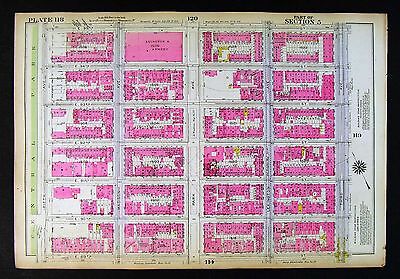
$4.99 Shipping Location: Fairview, United States Lake Erie Maps& Prints! An Authentic Antique Map: Not a Modern Reproduction! Click here for more! Free Shipping on Purchases of 5 or More Maps and ... morePrints Description: It is an original antique map from G.W. Bromley's Land Book of the Borough of Manhattan City of New York. Published in New York by Bromley& co. 1921. A facsimile copy of the title page will also be included for authenticity. The maps were mainly used by developers and real estate agents who periodically would receive updates of the building changes such as ownership or new structures that were issued as small cutouts that were then glued to update the map thus giving the map a unique character over time. It is handcolored probably with the use of stencils typical of the period. We have currenly listed many additional plates, click here New York City Maps. Please Note: There are two maps printed back to back on one sheet so if framing one would need to chose a side. It is not mounted. Matted nor framed, being sold as shown in the main pic. Size: The map image measures approximately 10 by 15 inches(25x38cm) on a 11 1/2 by 16 1/4" 29x41cm) page with a margin all around for framing as seen in the pic. Condition: The map is in Very Good overall condition with original hand coloring. There is light tonal ageing. Darkening around the edges, crimping along the binding edge, see the pics for more on condition. Overall, it is very clean with bright hand coloring that would frame up nicely. The pics are of the actual map. Payment Details: We accept most major credit cards through Paypal and Ebay. Please ask if you have any questions about payment. International and New Bidders are welcomed and encouraged. Payment is expected within 7 days. After which Nonpaying Bidders will be reported to Ebay to recoup our listing fees. Save on Shipping: We only charge one shipping fee based on the largest map or print with multiple items shipped along with it for no extra costs. Purchase 5 or more maps or prints and receive Free First Class shipping in USA o
Buy It Now
$9.99 Shipping Location: Calhan, United States Edition of 1894, reprinted 1921. The map has creasing throughout, small tears along the edges, and discoloration due to age as shown in the photos.
Buy It Now
$9.99 Shipping Location: Calhan, United States Edition of 1892, reprinted 1921.
Buy It Now
$9.99 Shipping Location: Calhan, United States Edition of 1893, reprinted 1921. The map has creasing throughout, small tears along the edges, and discoloration due to age as shown in the photos.
Buy It Now
$3.00 Shipping Location: Rockville, United States Map is generally in Good condition. Creases in the corners. On the reverse side is an official index showing population of states. I would be happy to ... moreinclude a copy if requested.
Buy It Now
$5.75 Shipping Location: Malden, United States Antique 1921 World Atlas City Map Baltimore, MD. Great OLD Map from the "COLLIER'S NEW ENCYCLOPEDIC ATLAS & GAZETTEER OF THE WORLD". An Amazing Map! Very ... moreEducational. See what the City used to look like!
Buy It Now
$5.95 Shipping Location: Farmington, United States Antique map of the Country Switzerland. Very nice shape and ready for framing.
Buy It Now
$6.97 Shipping Location: Bluffton, United States The other side is West Indies text facts. Sourced from a period atlas dated 1921. Large 14 x 11 sheet with a map inside the border of 9 3/16" x 12 7/16". ... moreINV: angel.1921-1.
Buy It Now
$4.99 Shipping Location: Fairview, United States Land Book of the Borough of Manhattan City of New York, published in New York by Bromley & co., 1921. A facsimile copy of the title page will also be ... moreincluded for authenticity. It is handcolored probably with the use of stencils typical of the period.
Buy It Now
Free Shipping Location: San Antonio, United States This Map was removed from a 1921 Atlas and is in good / fair condition. This map is not new or in new condition. It was printed in 1921. The large page ... moreis approx. There is no date on this map.

$6.80 Shipping Location: Hampton, United States NOTE: I am not a map expert. If you have any questions at all or need a clarifying picture please contact me before buying. I will be putting up in my ... morestore several hundred books from my own private library and several hundred Antiquarian books that I inherited. Thank you for looking at my item. You can visit my store and see other fine and fun collectables that I am selling. Again. If you have any questions, please contact me. If you buy more than one book at the same time and ship to the same address- I will combine shipping costs for you! We aim to ship within one business day from date of payment received. I will be using packaging that will ensure the safe arrival of your item! SATISFACTION GUARANTEED! I want you to be happy with your purchase. If for any reason you are not 100% percent satisfied please notify me so that I can resolve any issues. If you are satisfied with your purchase and service. Please give me feedback. If you are not happy[anything less than a 5 on the feedback survey] Please contact me so that I can remedy any problems and ensure that buying from me was a good experience! Please do not hesitate to contact me with any questions you may have! I can usually respond in less than 12 hours. Invoicing If you are buying more than one item. Please wait for an invoice before making your payment. International bidders are always welcome. But please wait to be invoiced before making payment. Shipping Details: All shipping originates from 02538 zip code and is shipped via the US Postal Service. Your item will be very carefully packed and will ship in a box in order to ensure that it reaches you safely! You will receive a delivery tracking number via email. Shipping within the United States: I will ship USPS mail unless you notify me and request another shipment method. Shipping Internationally: International Flat Rate Box for most items. Please wait for an invoice that will show shipping costs before submitting payment. Standard shipping costs will include postage and a $2 handling fee. If
Buy It Now
$9.99 Shipping Location: Calhan, United States Edition of 1896, reprinted 1921. The map has creasing throughout, small tears along the edges, and discoloration due to age as shown in the photos.
Buy It Now
$7.00 Shipping Location: Rockville, United States This map is from the "STANDARD ATLAS OF HARLAN COUNTY - NEBRASKA". Map of the State, United States and World. Compiled and published by George A. Ogle ... more& Co., Publishers & Engravers, Chicago. Either side would be great to own.
Buy It Now
$4.99 Shipping Location: Fairview, United States There is another map on the reverse. The pics are of the actual map. An Authentic Antique Map: Not a Modern Reproduction!
Buy It Now
$4.95 Shipping Location: Willow Grove, United States There is a map image and text on the reverse side of this map page.
Buy It Now
Free Shipping Location: San Antonio, United States This Map was removed from a 1921 Atlas and is in good / fair condition. This map is not new or in new condition. It was printed in 1921. The large double ... morepage is approx. There is no date on this map.
Buy It Now
Free Shipping Location: Florence, United States It's full of cool stuff!
Buy It Now
Free Shipping Location: Schertz, United States This antique original plat atlas map from 1921 features OAK Twp., NEBRASKA and was printed by Anderson Publishing Co. Measuring approximately 14" x 17", ... morethis map is a rare find for collectors and enthusiasts of North America maps. The map page is in its original state and comes with free S&H within the USA, with calculated S&H available worldwide. It is important to note that this map is a vintage piece and may show signs of wear due to its age, but is still a wonderful piece of history.
Buy It Now
$4.99 Shipping Location: Fairview, United States Land Book of the Borough of Manhattan City of New York, published in New York by Bromley & co., 1921. A facsimile copy of the title page will also be ... moreincluded for authenticity. It is handcolored probably with the use of stencils typical of the period.
Buy It Now
Free Shipping Location: Schertz, United States Explore the beautiful historical cartographic representation of Waverly Township, Nebraska with this 1921 Plat Atlas Map. Measuring approximately 14" ... morex 17", this antique original map page was printed by the Anderson Publishing Co. The map provides an accurate depiction of the Lancaster County and is perfect for collectors, historians, and enthusiasts alike. With free S&H within the USA and calculated S&H worldwide, this map is a must-have addition to any collection.
Buy It Now
$5.75 Shipping Location: Malden, United States A Fantastic Gift For The WWI Buff! Great OLD Map from the Collier's "The New Encyclopedic Atlas & Gazetteer of The World". From Early 1925. A Great Addition ... moreTo Your World War I Collection! On one side is Russia With An Inset of Leningrad.
Buy It Now
Free Shipping Location: Schertz, United States This antique plat atlas map of West Oak Township, Nebraska was printed in 1921 by Anderson Publishing Co. Its dimensions are approximately 14" x 17" and ... moreit is in its original form. The map is a genuine antique original and is a valuable addition to any collection of North America maps, maps, atlases & globes, and antiques. The item will be shipped for free within the USA and calculated shipping charges will apply for international orders.
Buy It Now
Free Shipping Location: Schertz, United States This antique original plat atlas map of Saltillo Township in Lancaster County, Nebraska was printed in 1921 by Anderson Publishing Co. The map measures ... moreapproximately 14" x 17" and is a valuable addition to any North America maps or antique collections. The map is in its original form and comes with free shipping within the USA, with calculated shipping available for worldwide delivery. This unique piece is a great item for collectors and enthusiasts alike, and provides an interesting glimpse into the history of the area.
Buy It Now
Free Shipping Location: Schertz, United States This antique plat atlas map depicts Nemaha Township in Lancaster County, Nebraska, printed by Anderson Publishing Co. in 1921. Measuring approximately ... more14" x 17", this original map page is perfect for collectors and history enthusiasts alike. The map is in its authentic condition and comes with free shipping within the USA. Shipping charges are calculated for worldwide delivery. Add this 1921 Nemaha Township Plat Map to your collection today!
Buy It Now
Free Shipping Location: Schertz, United States This antique original map/chart features the Principal Meridians and Base Lines in the United States and was printed in 1921 by Anderson Publishing Co. ... moreMeasuring approximately 17" x 28", this plat atlas map is a great addition to any collection of North America maps, maps, atlases, and globes. The shipping and handling for this item is free in the USA and calculated for worldwide shipping.
Buy It Now
Free Shipping Location: Marietta, United States AT BOTTOM IS A LIST OF SMALL PROPERTY OWNERS. DATE 1921, NOT ON MAP. GOOD CONDITION, DISCOLORATION DUE TO AGE.
Buy It Now
$4.95 Shipping Location: Willow Grove, United States There is a map image and text on the reverse side of this map page.
Buy It Now
Free Shipping Location: San Antonio, United States This Map was removed from a 1921 Atlas and is in good / fair condition. This map is not new or in new condition. It was printed in 1921. The large double ... morepage is approx. There is no date on this map.
Buy It Now
Free Shipping Location: Florence, United States It's full of cool stuff! Wrinkle in margin.
Buy It Now
$4.00 Shipping Location: Harborton, United States
Buy It Now
$4.00 Shipping Location: Harborton, United States This is an antique map of Brooklyn which was carefully removed from an atlas published in 1921.
Buy It Now
$5.95 Shipping Location: Cannon Beach, United States Antique map taken out of an old atlas. Not a reproduction. Map is on heavier paper and shows signs of age.
Buy It Now
Free Shipping Location: Seattle, United States AT BOTTOM IS A LIST OF SMALL PROPERTY OWNERS. DATE 1921, NOT ON MAP. FAIR CONDITION, DISCOLORATION DUE TO AGE.
|
|
|
|
MAP OF PEDMORE 1921
Here we have this lovely modern reproduction map of PEDMORE showing the area as it was back in 1921 PLACES SHOWN ALONG THE TOP INCLUDE PEDMORE COMMON. THE QUARRY, NEW ROAD, PEDMORE FARM PLACES SHOWN DOWN THE LEFT SIDE INCLUDE RACECOURSE LANE PLACES SHOWN ALONG THE BOTTOM INCLUDE THE BIRCHES. HOLLIER'S FARM, HAGLEY HOUSE PLACES SHOWN DOWN THE RIGHT SIDE INCLUDE PEDMORE LANE. HAGLEY, ROCKINGHAM HALL The scale is an impressive 15 inches to the mile. Clearly showing street names, buildings, farm houses etc! THIS MAP IS IN PAPER FORM AND WHEN OPENED MEASURES APPROXIMATELY 2FT x 1.5FT It makes for a great reference source when trying to pinpoint the residences of your ancestors. Just a handy size for walking around with& equally nice to frame! Please note that we cannot consult maps. For instance to tell you if a specific street is listed ... moreon it. We offer you an overview i.e from one point to another in most cases, but to start looking at maps for individual streets is not possible, most people take the view that for the small amount of money involved it's worth taking a gamble on the map showing what they are looking for. STOP PRESS! TAKE A LOOK AT A FANTASTIC RANGE OF OLD ORDNANCE SURVEY MAPS THAT WE HAVE FOR SALE ON EBAY" JUST CLICK ON VIEW SELLERS OTHER ITEMS" FROM THIS PAGE. OVER 2.000 ARE AVAILABLE COVERING VIRTUALLY EVERY REGION THROUGHOUT THE UNITED KINGDOM We have Town Directories. Census, Parish Registers, Quarter Sessions, Military Information on CD ROM, please browse our pages to see what we are currently selling! COPYRIGHT NOTICE Buyers are granted a read only licence. Anyone found to be reproducing our CD ROMs WILL BE TRACKED DOWN& PROSECUTED Powered by
|
|
|
Vintage Ordnance Survey Contoured Cloth Road Map of the Isle of Man 1921 Edition
Our three hospices in east Kent provide specialist palliative care and support for our patients. Their families and their carers. It costs £9m a year to provide these priceless services. Vintage Ordnance Survey Contoured Cloth Road Map of the Isle of Man 1921 Edition Description Vintage Ordnance Survey Contoured Cloth Road Map of the Isle of Man. Scale one inch to one mile. Revised edition 1921. Size 68.5cm x 77cm. Condition Some marks. Otherwise good for its age. Additional Information None. Packaging We take pride in packing well in order to protect your purchase. Other than cartons. We use all-new professional quality packing materials. The price of these has to be reflected in our shipping costs. Postage For your protection if your item is worth more than £45. We recommend trackable signed-for delivery. UK: Recorded or Special ... moreDelivery. International: Signed-for, or Airsure, where available) Please ask us to add the cost to your invoice before paying. Multiple Purchases Where possible we will combine the postage on multiple purchases. Please wait for an invoice. Which we will issue on the next working day. Contact Us We want you to be happy with your purchase. If you wish to contact us please use the eBay message service in preference to telephone or direct email. Our office is open Monday to Friday. 0830- 1630 UK time. Powered by
|
|
|
LONDON SW: Richmond Wimbledon Putney Twickenham Kingston-upon-Thames, 1921 map
Richmond and Wimbledon Vintage colour map. 1921 Title of map: Richmond and Wimbledon' The image below shows an enlarged cross section from the centre of the map to show the level of printed detail: DATE PRINTED: 1921 IMAGE SIZE: Approx 21.5 x 27.0cm. 8.5 x 10.5 inches(Medium) ARTIST/CARTOGRAPHER/ENGRAVER: John Bartholomew PROVENANCE: Handy Reference Atlas of London and Suburbs" by J. G. Bartholomew; Published by John Bartholomew& Son Ltd. Edinburgh. Fourth edition TYPE: Vintage colour map VERSO: There are images and/or text printed on the reverse side of the picture. In some cases this may be visible on the picture itself(please check the scan prior to your purchase) or around the margin of the picture CONDITION: Good; suitable for framing. However. Please note: This map was originally printed as two separate pages which have ... morebeen professionally joined to form a single sheet; The image shown may have been taken from a different example of this map than that which is offered for sale. The map you will receive is in good condition but there may be minor variations in the condition from that shown in the image. Please check the scan for any blemishes prior to making your purchase. Virtually all antiquarian maps and prints are subject to some normal aging due to use and time which is not obtrusive unless otherwise stated. I offer a no questions asked return policy- see below. AUTHENTICITY: This is an authentic historic print. Published at the date stated above. I do not offer reproductions. It is not a modern copy. The term'original' when applied to a print means that it was printed at the first or original date of publication; it does not imply that the item is unique. Print' means any image created by applying an inked block to paper or card under pressure by any method including wood engraving, steel engraving, copperplate, wood cut and lithography. REMARKS: FRANCE: Gravures et Cartes anciennes. DEUTSCHLAND: Alte Lankarten und Stadt ansichten. ITALIA: Stampe& Mappe antiche. ESPAÑA
|
|
|
LONDON:Hammersmith Kensington Shepherds Bush Earls Court Notting Hill, 1921 map
Hammersmith and Kensington Vintage colour map. 1921 Title of map: Hammersmith and Kensington' The image below shows an enlarged cross section from the centre of the map to show the level of printed detail: DATE PRINTED: 1921 IMAGE SIZE: Approx 21.5 x 27.0cm. 8.5 x 10.5 inches(Medium) ARTIST/CARTOGRAPHER/ENGRAVER: John Bartholomew PROVENANCE: Handy Reference Atlas of London and Suburbs" by J. G. Bartholomew; Published by John Bartholomew& Son Ltd. Edinburgh. Fourth edition TYPE: Vintage colour map VERSO: There are images and/or text printed on the reverse side of the picture. In some cases this may be visible on the picture itself(please check the scan prior to your purchase) or around the margin of the picture CONDITION: Good; suitable for framing. However. Please note: This map was originally printed as two separate pages which ... morehave been professionally joined to form a single sheet; The image shown may have been taken from a different example of this map than that which is offered for sale. The map you will receive is in good condition but there may be minor variations in the condition from that shown in the image. Please check the scan for any blemishes prior to making your purchase. Virtually all antiquarian maps and prints are subject to some normal aging due to use and time which is not obtrusive unless otherwise stated. I offer a no questions asked return policy- see below. AUTHENTICITY: This is an authentic historic print. Published at the date stated above. I do not offer reproductions. It is not a modern copy. The term'original' when applied to a print means that it was printed at the first or original date of publication; it does not imply that the item is unique. Print' means any image created by applying an inked block to paper or card under pressure by any method including wood engraving, steel engraving, copperplate, wood cut and lithography. REMARKS: FRANCE: Gravures et Cartes anciennes. DEUTSCHLAND: Alte Lankarten und Stadt ansichten. ITALIA: Stampe& Mappe antiche. ESP
|
|
|
LONDON N:Hampstead Holloway Highgate Kentish Town Belsize Park Camden, 1921 map
Hampstead and Holloway Vintage colour map. 1921 Title of map: Hampstead and Holloway' The image below shows an enlarged cross section from the centre of the map to show the level of printed detail: DATE PRINTED: 1921 IMAGE SIZE: Approx 21.5 x 27.0cm. 8.5 x 10.5 inches(Medium) ARTIST/CARTOGRAPHER/ENGRAVER: John Bartholomew PROVENANCE: Handy Reference Atlas of London and Suburbs" by J. G. Bartholomew; Published by John Bartholomew& Son Ltd. Edinburgh. Fourth edition TYPE: Vintage colour map VERSO: There are images and/or text printed on the reverse side of the picture. In some cases this may be visible on the picture itself(please check the scan prior to your purchase) or around the margin of the picture CONDITION: Good; suitable for framing. However. Please note: This map was originally printed as two separate pages which have ... morebeen professionally joined to form a single sheet; The image shown may have been taken from a different example of this map than that which is offered for sale. The map you will receive is in good condition but there may be minor variations in the condition from that shown in the image. Please check the scan for any blemishes prior to making your purchase. Virtually all antiquarian maps and prints are subject to some normal aging due to use and time which is not obtrusive unless otherwise stated. I offer a no questions asked return policy- see below. AUTHENTICITY: This is an authentic historic print. Published at the date stated above. I do not offer reproductions. It is not a modern copy. The term'original' when applied to a print means that it was printed at the first or original date of publication; it does not imply that the item is unique. Print' means any image created by applying an inked block to paper or card under pressure by any method including wood engraving, steel engraving, copperplate, wood cut and lithography. REMARKS: FRANCE: Gravures et Cartes anciennes. DEUTSCHLAND: Alte Lankarten und Stadt ansichten. ITALIA: Stampe& Mappe antiche. ESPAÑA
|
|
|
LONDON SE: Plumstead Eltham Sidcup Mottingham Kidbrook Chislehurst, 1921 map
Plumstead. Eltham and Sidcup Vintage colour map. 1921 Title of map: Plumstead. Eltham and Sidcup' The image below shows an enlarged cross section from the centre of the map to show the level of printed detail: DATE PRINTED: 1921 IMAGE SIZE: Approx 21.5 x 27.0cm. 8.5 x 10.5 inches(Medium) ARTIST/CARTOGRAPHER/ENGRAVER: John Bartholomew PROVENANCE: Handy Reference Atlas of London and Suburbs" by J. G. Bartholomew; Published by John Bartholomew& Son Ltd. Edinburgh. Fourth edition TYPE: Vintage colour map VERSO: There are images and/or text printed on the reverse side of the picture. In some cases this may be visible on the picture itself(please check the scan prior to your purchase) or around the margin of the picture CONDITION: Good; suitable for framing. However. Please note: This map was originally printed as two separate pages ... morewhich have been professionally joined to form a single sheet; The image shown may have been taken from a different example of this map than that which is offered for sale. The map you will receive is in good condition but there may be minor variations in the condition from that shown in the image. Please check the scan for any blemishes prior to making your purchase. Virtually all antiquarian maps and prints are subject to some normal aging due to use and time which is not obtrusive unless otherwise stated. I offer a no questions asked return policy- see below. AUTHENTICITY: This is an authentic historic print. Published at the date stated above. I do not offer reproductions. It is not a modern copy. The term'original' when applied to a print means that it was printed at the first or original date of publication; it does not imply that the item is unique. Print' means any image created by applying an inked block to paper or card under pressure by any method including wood engraving, steel engraving, copperplate, wood cut and lithography. REMARKS: FRANCE: Gravures et Cartes anciennes. DEUTSCHLAND: Alte Lankarten und Stadt ansichten. ITALIA: Stampe& Mappe antiche.
|
|
|
LONDON: Regents Park Camden Town Marylebone St John's Wood Bloomsbury, 1921 map
Regents Park and Camden Town Vintage colour map. 1921 Title of map: Regents Park and Camden Town' The image below shows an enlarged cross section from the centre of the map to show the level of printed detail: DATE PRINTED: 1921 IMAGE SIZE: Approx 21.5 x 27.0cm. 8.5 x 10.5 inches(Medium) ARTIST/CARTOGRAPHER/ENGRAVER: John Bartholomew PROVENANCE: Handy Reference Atlas of London and Suburbs" by J. G. Bartholomew; Published by John Bartholomew& Son Ltd. Edinburgh. Fourth edition TYPE: Vintage colour map VERSO: There are images and/or text printed on the reverse side of the picture. In some cases this may be visible on the picture itself(please check the scan prior to your purchase) or around the margin of the picture CONDITION: Good; suitable for framing. However. Please note: This map was originally printed as two separate pages ... morewhich have been professionally joined to form a single sheet; The image shown may have been taken from a different example of this map than that which is offered for sale. The map you will receive is in good condition but there may be minor variations in the condition from that shown in the image. Please check the scan for any blemishes prior to making your purchase. Virtually all antiquarian maps and prints are subject to some normal aging due to use and time which is not obtrusive unless otherwise stated. I offer a no questions asked return policy- see below. AUTHENTICITY: This is an authentic historic print. Published at the date stated above. I do not offer reproductions. It is not a modern copy. The term'original' when applied to a print means that it was printed at the first or original date of publication; it does not imply that the item is unique. Print' means any image created by applying an inked block to paper or card under pressure by any method including wood engraving, steel engraving, copperplate, wood cut and lithography. REMARKS: FRANCE: Gravures et Cartes anciennes. DEUTSCHLAND: Alte Lankarten und Stadt ansichten. ITALIA: Stampe& Mappe antiche.
|
|
|
LONDON SW:Richmond Mortlake Kew Twickenham Barnes E Sheen Petersham, 1921 map
Richmond and Mortlake Vintage colour map. 1921 Title of map: Richmond and Mortlake' The image below shows an enlarged cross section from the centre of the map to show the level of printed detail: DATE PRINTED: 1921 IMAGE SIZE: Approx 21.5 x 27.0cm. 8.5 x 10.5 inches(Medium) ARTIST/CARTOGRAPHER/ENGRAVER: John Bartholomew PROVENANCE: Handy Reference Atlas of London and Suburbs" by J. G. Bartholomew; Published by John Bartholomew& Son Ltd. Edinburgh. Fourth edition TYPE: Vintage colour map VERSO: There are images and/or text printed on the reverse side of the picture. In some cases this may be visible on the picture itself(please check the scan prior to your purchase) or around the margin of the picture CONDITION: Good; suitable for framing. However. Please note: This map was originally printed as two separate pages which have been ... moreprofessionally joined to form a single sheet; The image shown may have been taken from a different example of this map than that which is offered for sale. The map you will receive is in good condition but there may be minor variations in the condition from that shown in the image. Please check the scan for any blemishes prior to making your purchase. Virtually all antiquarian maps and prints are subject to some normal aging due to use and time which is not obtrusive unless otherwise stated. I offer a no questions asked return policy- see below. AUTHENTICITY: This is an authentic historic print. Published at the date stated above. I do not offer reproductions. It is not a modern copy. The term'original' when applied to a print means that it was printed at the first or original date of publication; it does not imply that the item is unique. Print' means any image created by applying an inked block to paper or card under pressure by any method including wood engraving, steel engraving, copperplate, wood cut and lithography. REMARKS: FRANCE: Gravures et Cartes anciennes. DEUTSCHLAND: Alte Lankarten und Stadt ansichten. ITALIA: Stampe& Mappe antiche. ESPAÑA:
|
|
|
LONDON:Railways Postal Districts.Underground tube lines, 1921 vintage map
Railways and Postal Districts Vintage colour map. 1921 Title of map: Railways and Postal Districts' The image below shows an enlarged cross section from the centre of the map to show the level of printed detail: DATE PRINTED: 1921 IMAGE SIZE: Approx 21.5 x 27.0cm. 8.5 x 10.5 inches(Medium) ARTIST/CARTOGRAPHER/ENGRAVER: John Bartholomew PROVENANCE: Handy Reference Atlas of London and Suburbs" by J. G. Bartholomew; Published by John Bartholomew& Son Ltd. Edinburgh. Fourth edition TYPE: Vintage colour map VERSO: There are images and/or text printed on the reverse side of the picture. In some cases this may be visible on the picture itself(please check the scan prior to your purchase) or around the margin of the picture CONDITION: Good; suitable for framing. However. Please note: This map was originally printed as two separate pages ... morewhich have been professionally joined to form a single sheet; The image shown may have been taken from a different example of this map than that which is offered for sale. The map you will receive is in good condition but there may be minor variations in the condition from that shown in the image. Please check the scan for any blemishes prior to making your purchase. Virtually all antiquarian maps and prints are subject to some normal aging due to use and time which is not obtrusive unless otherwise stated. I offer a no questions asked return policy- see below. AUTHENTICITY: This is an authentic historic print. Published at the date stated above. I do not offer reproductions. It is not a modern copy. The term'original' when applied to a print means that it was printed at the first or original date of publication; it does not imply that the item is unique. Print' means any image created by applying an inked block to paper or card under pressure by any method including wood engraving, steel engraving, copperplate, wood cut and lithography. REMARKS: FRANCE: Gravures et Cartes anciennes. DEUTSCHLAND: Alte Lankarten und Stadt ansichten. ITALIA: Stampe& Mappe antich
|
|
|
LONDON NE:Walthamstow Snaresbrook Wanstead Higham Hill Woodford Green, 1921 map
Walthamstow and Snaresbrook Vintage colour map. 1921 Title of map: Walthamstow and Snaresbrook' The image below shows an enlarged cross section from the centre of the map to show the level of printed detail: DATE PRINTED: 1921 IMAGE SIZE: Approx 21.5 x 27.0cm. 8.5 x 10.5 inches(Medium) ARTIST/CARTOGRAPHER/ENGRAVER: John Bartholomew PROVENANCE: Handy Reference Atlas of London and Suburbs" by J. G. Bartholomew; Published by John Bartholomew& Son Ltd. Edinburgh. Fourth edition TYPE: Vintage colour map VERSO: There are images and/or text printed on the reverse side of the picture. In some cases this may be visible on the picture itself(please check the scan prior to your purchase) or around the margin of the picture CONDITION: Good; suitable for framing. However. Please note: This map was originally printed as two separate pages ... morewhich have been professionally joined to form a single sheet; The image shown may have been taken from a different example of this map than that which is offered for sale. The map you will receive is in good condition but there may be minor variations in the condition from that shown in the image. Please check the scan for any blemishes prior to making your purchase. Virtually all antiquarian maps and prints are subject to some normal aging due to use and time which is not obtrusive unless otherwise stated. I offer a no questions asked return policy- see below. AUTHENTICITY: This is an authentic historic print. Published at the date stated above. I do not offer reproductions. It is not a modern copy. The term'original' when applied to a print means that it was printed at the first or original date of publication; it does not imply that the item is unique. Print' means any image created by applying an inked block to paper or card under pressure by any method including wood engraving, steel engraving, copperplate, wood cut and lithography. REMARKS: FRANCE: Gravures et Cartes anciennes. DEUTSCHLAND: Alte Lankarten und Stadt ansichten. ITALIA: Stampe& Mappe antiche. E
|
|
|
LONDON SE: Rushey Green Grove Park Catford Lower Sydenham Beckenham, 1921 map
Rushey Green and Grove Park Vintage colour map. 1921 Title of map: Rushey Green and Grove Park' The image below shows an enlarged cross section from the centre of the map to show the level of printed detail: DATE PRINTED: 1921 IMAGE SIZE: Approx 21.5 x 27.0cm. 8.5 x 10.5 inches(Medium) ARTIST/CARTOGRAPHER/ENGRAVER: John Bartholomew PROVENANCE: Handy Reference Atlas of London and Suburbs" by J. G. Bartholomew; Published by John Bartholomew& Son Ltd. Edinburgh. Fourth edition TYPE: Vintage colour map VERSO: There are images and/or text printed on the reverse side of the picture. In some cases this may be visible on the picture itself(please check the scan prior to your purchase) or around the margin of the picture CONDITION: Good; suitable for framing. However. Please note: This map was originally printed as two separate pages ... morewhich have been professionally joined to form a single sheet; The image shown may have been taken from a different example of this map than that which is offered for sale. The map you will receive is in good condition but there may be minor variations in the condition from that shown in the image. Please check the scan for any blemishes prior to making your purchase. Virtually all antiquarian maps and prints are subject to some normal aging due to use and time which is not obtrusive unless otherwise stated. I offer a no questions asked return policy- see below. AUTHENTICITY: This is an authentic historic print. Published at the date stated above. I do not offer reproductions. It is not a modern copy. The term'original' when applied to a print means that it was printed at the first or original date of publication; it does not imply that the item is unique. Print' means any image created by applying an inked block to paper or card under pressure by any method including wood engraving, steel engraving, copperplate, wood cut and lithography. REMARKS: FRANCE: Gravures et Cartes anciennes. DEUTSCHLAND: Alte Lankarten und Stadt ansichten. ITALIA: Stampe& Mappe antiche. E
|
|
|
LONDON: Kilburn St John's Wood Maida Vale Bayswater Notting Hill, 1921 old map
Kensal Green and Kilburn Vintage colour map. 1921 Title of map: Kensal Green and Kilburn' The image below shows an enlarged cross section from the centre of the map to show the level of printed detail: DATE PRINTED: 1921 IMAGE SIZE: Approx 21.5 x 27.0cm. 8.5 x 10.5 inches(Medium) ARTIST/CARTOGRAPHER/ENGRAVER: John Bartholomew PROVENANCE: Handy Reference Atlas of London and Suburbs" by J. G. Bartholomew; Published by John Bartholomew& Son Ltd. Edinburgh. Fourth edition TYPE: Vintage colour map VERSO: There are images and/or text printed on the reverse side of the picture. In some cases this may be visible on the picture itself(please check the scan prior to your purchase) or around the margin of the picture CONDITION: Good; suitable for framing. However. Please note: This map was originally printed as two separate pages which ... morehave been professionally joined to form a single sheet; The image shown may have been taken from a different example of this map than that which is offered for sale. The map you will receive is in good condition but there may be minor variations in the condition from that shown in the image. Please check the scan for any blemishes prior to making your purchase. Virtually all antiquarian maps and prints are subject to some normal aging due to use and time which is not obtrusive unless otherwise stated. I offer a no questions asked return policy- see below. AUTHENTICITY: This is an authentic historic print. Published at the date stated above. I do not offer reproductions. It is not a modern copy. The term'original' when applied to a print means that it was printed at the first or original date of publication; it does not imply that the item is unique. Print' means any image created by applying an inked block to paper or card under pressure by any method including wood engraving, steel engraving, copperplate, wood cut and lithography. REMARKS: FRANCE: Gravures et Cartes anciennes. DEUTSCHLAND: Alte Lankarten und Stadt ansichten. ITALIA: Stampe& Mappe antiche. ESPA�
|
|
|
LONDON W: Ealing Acton Chiswick Kew Brentford Willesden Alperton, 1921 old map
Ealing. Acton and Chiswick Vintage colour map. 1921 Title of map: Ealing. Acton and Chiswick' The image below shows an enlarged cross section from the centre of the map to show the level of printed detail: DATE PRINTED: 1921 IMAGE SIZE: Approx 21.5 x 27.0cm. 8.5 x 10.5 inches(Medium) ARTIST/CARTOGRAPHER/ENGRAVER: John Bartholomew PROVENANCE: Handy Reference Atlas of London and Suburbs" by J. G. Bartholomew; Published by John Bartholomew& Son Ltd. Edinburgh. Fourth edition TYPE: Vintage colour map VERSO: There are images and/or text printed on the reverse side of the picture. In some cases this may be visible on the picture itself(please check the scan prior to your purchase) or around the margin of the picture CONDITION: Good; suitable for framing. However. Please note: This map was originally printed as two separate pages which ... morehave been professionally joined to form a single sheet; The image shown may have been taken from a different example of this map than that which is offered for sale. The map you will receive is in good condition but there may be minor variations in the condition from that shown in the image. Please check the scan for any blemishes prior to making your purchase. Virtually all antiquarian maps and prints are subject to some normal aging due to use and time which is not obtrusive unless otherwise stated. I offer a no questions asked return policy- see below. AUTHENTICITY: This is an authentic historic print. Published at the date stated above. I do not offer reproductions. It is not a modern copy. The term'original' when applied to a print means that it was printed at the first or original date of publication; it does not imply that the item is unique. Print' means any image created by applying an inked block to paper or card under pressure by any method including wood engraving, steel engraving, copperplate, wood cut and lithography. REMARKS: FRANCE: Gravures et Cartes anciennes. DEUTSCHLAND: Alte Lankarten und Stadt ansichten. ITALIA: Stampe& Mappe antiche. ESP
|
|
|
LONDON: Index map of London. Railways. BARTHOLOMEW, 1921
Index map of London Vintage colour map. 1921 Title of map: Index map of London' The image below shows an enlarged cross section from the centre of the map to show the level of printed detail: DATE PRINTED: 1921 IMAGE SIZE: Approx 21.5 x 13.0cm. 8.5 x 5.25 inches(Medium) ARTIST/CARTOGRAPHER/ENGRAVER: John Bartholomew PROVENANCE: Handy Reference Atlas of London and Suburbs" by J. G. Bartholomew; Published by John Bartholomew& Son Ltd. Edinburgh. Fourth edition TYPE: Vintage colour map VERSO: There are images and/or text printed on the reverse side of the picture. In some cases this may be visible on the picture itself(please check the scan prior to your purchase) or around the margin of the picture CONDITION: Good; suitable for framing. However. Please note: This map was originally printed as two separate pages which have been ... moreprofessionally joined to form a single sheet; The image shown may have been taken from a different example of this map than that which is offered for sale. The map you will receive is in good condition but there may be minor variations in the condition from that shown in the image. Please check the scan for any blemishes prior to making your purchase. Virtually all antiquarian maps and prints are subject to some normal aging due to use and time which is not obtrusive unless otherwise stated. I offer a no questions asked return policy- see below. AUTHENTICITY: This is an authentic historic print. Published at the date stated above. I do not offer reproductions. It is not a modern copy. The term'original' when applied to a print means that it was printed at the first or original date of publication; it does not imply that the item is unique. Print' means any image created by applying an inked block to paper or card under pressure by any method including wood engraving, steel engraving, copperplate, wood cut and lithography. REMARKS: FRANCE: Gravures et Cartes anciennes. DEUTSCHLAND: Alte Lankarten und Stadt ansichten. ITALIA: Stampe& Mappe antiche. ESPAÑA: Mapa
|
|
|
LONDON NE: Wanstead Ilford Manor Park Seven Kings Wood Grange, 1921 old map
Wanstead Park and Ilford Vintage colour map. 1921 Title of map: Wanstead Park and Ilford' The image below shows an enlarged cross section from the centre of the map to show the level of printed detail: DATE PRINTED: 1921 IMAGE SIZE: Approx 21.5 x 27.0cm. 8.5 x 10.5 inches(Medium) ARTIST/CARTOGRAPHER/ENGRAVER: John Bartholomew PROVENANCE: Handy Reference Atlas of London and Suburbs" by J. G. Bartholomew; Published by John Bartholomew& Son Ltd. Edinburgh. Fourth edition TYPE: Vintage colour map VERSO: There are images and/or text printed on the reverse side of the picture. In some cases this may be visible on the picture itself(please check the scan prior to your purchase) or around the margin of the picture CONDITION: Good; suitable for framing. However. Please note: This map was originally printed as two separate pages which ... morehave been professionally joined to form a single sheet; The image shown may have been taken from a different example of this map than that which is offered for sale. The map you will receive is in good condition but there may be minor variations in the condition from that shown in the image. Please check the scan for any blemishes prior to making your purchase. Virtually all antiquarian maps and prints are subject to some normal aging due to use and time which is not obtrusive unless otherwise stated. I offer a no questions asked return policy- see below. AUTHENTICITY: This is an authentic historic print. Published at the date stated above. I do not offer reproductions. It is not a modern copy. The term'original' when applied to a print means that it was printed at the first or original date of publication; it does not imply that the item is unique. Print' means any image created by applying an inked block to paper or card under pressure by any method including wood engraving, steel engraving, copperplate, wood cut and lithography. REMARKS: FRANCE: Gravures et Cartes anciennes. DEUTSCHLAND: Alte Lankarten und Stadt ansichten. ITALIA: Stampe& Mappe antiche. ESPA�
|
|
|
LONDON E: East Ham Barking Plaistow Beckton Cyprus Plashet Upton Park, 1921 map
East Ham and Barking Vintage colour map. 1921 Title of map: East Ham and Barking' The image below shows an enlarged cross section from the centre of the map to show the level of printed detail: DATE PRINTED: 1921 IMAGE SIZE: Approx 21.5 x 27.0cm. 8.5 x 10.5 inches(Medium) ARTIST/CARTOGRAPHER/ENGRAVER: John Bartholomew PROVENANCE: Handy Reference Atlas of London and Suburbs" by J. G. Bartholomew; Published by John Bartholomew& Son Ltd. Edinburgh. Fourth edition TYPE: Vintage colour map VERSO: There are images and/or text printed on the reverse side of the picture. In some cases this may be visible on the picture itself(please check the scan prior to your purchase) or around the margin of the picture CONDITION: Good; suitable for framing. However. Please note: This map was originally printed as two separate pages which have been ... moreprofessionally joined to form a single sheet; The image shown may have been taken from a different example of this map than that which is offered for sale. The map you will receive is in good condition but there may be minor variations in the condition from that shown in the image. Please check the scan for any blemishes prior to making your purchase. Virtually all antiquarian maps and prints are subject to some normal aging due to use and time which is not obtrusive unless otherwise stated. I offer a no questions asked return policy- see below. AUTHENTICITY: This is an authentic historic print. Published at the date stated above. I do not offer reproductions. It is not a modern copy. The term'original' when applied to a print means that it was printed at the first or original date of publication; it does not imply that the item is unique. Print' means any image created by applying an inked block to paper or card under pressure by any method including wood engraving, steel engraving, copperplate, wood cut and lithography. REMARKS: FRANCE: Gravures et Cartes anciennes. DEUTSCHLAND: Alte Lankarten und Stadt ansichten. ITALIA: Stampe& Mappe antiche. ESPAÑA: Ma
|
|
|
LONDON S: Norwood Sydenham Dulwich Forest Hill Penge Perryvale, 1921 old map
Norwood and Sydenham Vintage colour map. 1921 Title of map: Norwood and Sydenham' The image below shows an enlarged cross section from the centre of the map to show the level of printed detail: DATE PRINTED: 1921 IMAGE SIZE: Approx 21.5 x 27.0cm. 8.5 x 10.5 inches(Medium) ARTIST/CARTOGRAPHER/ENGRAVER: John Bartholomew PROVENANCE: Handy Reference Atlas of London and Suburbs" by J. G. Bartholomew; Published by John Bartholomew& Son Ltd. Edinburgh. Fourth edition TYPE: Vintage colour map VERSO: There are images and/or text printed on the reverse side of the picture. In some cases this may be visible on the picture itself(please check the scan prior to your purchase) or around the margin of the picture CONDITION: Good; suitable for framing. However. Please note: This map was originally printed as two separate pages which have been ... moreprofessionally joined to form a single sheet; The image shown may have been taken from a different example of this map than that which is offered for sale. The map you will receive is in good condition but there may be minor variations in the condition from that shown in the image. Please check the scan for any blemishes prior to making your purchase. Virtually all antiquarian maps and prints are subject to some normal aging due to use and time which is not obtrusive unless otherwise stated. I offer a no questions asked return policy- see below. AUTHENTICITY: This is an authentic historic print. Published at the date stated above. I do not offer reproductions. It is not a modern copy. The term'original' when applied to a print means that it was printed at the first or original date of publication; it does not imply that the item is unique. Print' means any image created by applying an inked block to paper or card under pressure by any method including wood engraving, steel engraving, copperplate, wood cut and lithography. REMARKS: FRANCE: Gravures et Cartes anciennes. DEUTSCHLAND: Alte Lankarten und Stadt ansichten. ITALIA: Stampe& Mappe antiche. ESPAÑA: Ma
|
|
|
LONDON N: Wood Green Tottenham Harringay Higham Hill Upper Edmonton, 1921 map
Wood Green and Tottenham Vintage colour map. 1921 Title of map: Wood Green and Tottenham' The image below shows an enlarged cross section from the centre of the map to show the level of printed detail: DATE PRINTED: 1921 IMAGE SIZE: Approx 21.5 x 27.0cm. 8.5 x 10.5 inches(Medium) ARTIST/CARTOGRAPHER/ENGRAVER: John Bartholomew PROVENANCE: Handy Reference Atlas of London and Suburbs" by J. G. Bartholomew; Published by John Bartholomew& Son Ltd. Edinburgh. Fourth edition TYPE: Vintage colour map VERSO: There are images and/or text printed on the reverse side of the picture. In some cases this may be visible on the picture itself(please check the scan prior to your purchase) or around the margin of the picture CONDITION: Good; suitable for framing. However. Please note: This map was originally printed as two separate pages which ... morehave been professionally joined to form a single sheet; The image shown may have been taken from a different example of this map than that which is offered for sale. The map you will receive is in good condition but there may be minor variations in the condition from that shown in the image. Please check the scan for any blemishes prior to making your purchase. Virtually all antiquarian maps and prints are subject to some normal aging due to use and time which is not obtrusive unless otherwise stated. I offer a no questions asked return policy- see below. AUTHENTICITY: This is an authentic historic print. Published at the date stated above. I do not offer reproductions. It is not a modern copy. The term'original' when applied to a print means that it was printed at the first or original date of publication; it does not imply that the item is unique. Print' means any image created by applying an inked block to paper or card under pressure by any method including wood engraving, steel engraving, copperplate, wood cut and lithography. REMARKS: FRANCE: Gravures et Cartes anciennes. DEUTSCHLAND: Alte Lankarten und Stadt ansichten. ITALIA: Stampe& Mappe antiche. ESPA�
|
|
|
WEST END THEATRES: Covent Garden Shaftesbury Avenue &c , 1921 vintage map
London Theatres Vintage colour map. 1921 Title of map: London Theatres' The image below shows an enlarged cross section from the centre of the map to show the level of printed detail: DATE PRINTED: 1921 IMAGE SIZE: Approx 21.5 x 13.0cm. 8.5 x 5.25 inches(Medium) ARTIST/CARTOGRAPHER/ENGRAVER: John Bartholomew PROVENANCE: Handy Reference Atlas of London and Suburbs" by J. G. Bartholomew; Published by John Bartholomew& Son Ltd. Edinburgh. Fourth edition TYPE: Vintage colour map VERSO: There are images and/or text printed on the reverse side of the picture. In some cases this may be visible on the picture itself(please check the scan prior to your purchase) or around the margin of the picture CONDITION: Good; suitable for framing. However. Please note: This map was originally printed as two separate pages which have been professionally ... morejoined to form a single sheet; The image shown may have been taken from a different example of this map than that which is offered for sale. The map you will receive is in good condition but there may be minor variations in the condition from that shown in the image. Please check the scan for any blemishes prior to making your purchase. Virtually all antiquarian maps and prints are subject to some normal aging due to use and time which is not obtrusive unless otherwise stated. I offer a no questions asked return policy- see below. AUTHENTICITY: This is an authentic historic print. Published at the date stated above. I do not offer reproductions. It is not a modern copy. The term'original' when applied to a print means that it was printed at the first or original date of publication; it does not imply that the item is unique. Print' means any image created by applying an inked block to paper or card under pressure by any method including wood engraving, steel engraving, copperplate, wood cut and lithography. REMARKS: FRANCE: Gravures et Cartes anciennes. DEUTSCHLAND: Alte Lankarten und Stadt ansichten. ITALIA: Stampe& Mappe antiche. ESPAÑA: Mapas antiqu
|
|
|
LONDON E: Isle of Dogs Poplar Greenwich Surrey Docks Deptford, 1921 old map
Isle of Dogs and Blackwall Vintage colour map. 1921 Title of map: Isle of Dogs and Blackwall' The image below shows an enlarged cross section from the centre of the map to show the level of printed detail: DATE PRINTED: 1921 IMAGE SIZE: Approx 21.5 x 27.0cm. 8.5 x 10.5 inches(Medium) ARTIST/CARTOGRAPHER/ENGRAVER: John Bartholomew PROVENANCE: Handy Reference Atlas of London and Suburbs" by J. G. Bartholomew; Published by John Bartholomew& Son Ltd. Edinburgh. Fourth edition TYPE: Vintage colour map VERSO: There are images and/or text printed on the reverse side of the picture. In some cases this may be visible on the picture itself(please check the scan prior to your purchase) or around the margin of the picture CONDITION: Good; suitable for framing. However. Please note: This map was originally printed as two separate pages which ... morehave been professionally joined to form a single sheet; The image shown may have been taken from a different example of this map than that which is offered for sale. The map you will receive is in good condition but there may be minor variations in the condition from that shown in the image. Please check the scan for any blemishes prior to making your purchase. Virtually all antiquarian maps and prints are subject to some normal aging due to use and time which is not obtrusive unless otherwise stated. I offer a no questions asked return policy- see below. AUTHENTICITY: This is an authentic historic print. Published at the date stated above. I do not offer reproductions. It is not a modern copy. The term'original' when applied to a print means that it was printed at the first or original date of publication; it does not imply that the item is unique. Print' means any image created by applying an inked block to paper or card under pressure by any method including wood engraving, steel engraving, copperplate, wood cut and lithography. REMARKS: FRANCE: Gravures et Cartes anciennes. DEUTSCHLAND: Alte Lankarten und Stadt ansichten. ITALIA: Stampe& Mappe antiche. ESP
|
|
|
LONDON S: Battersea Clapham Stockwell Brixton Lambeth Balham Tulse H, 1921 map
Battersea and Clapham Vintage colour map. 1921 Title of map: Battersea and Clapham' The image below shows an enlarged cross section from the centre of the map to show the level of printed detail: DATE PRINTED: 1921 IMAGE SIZE: Approx 21.5 x 27.0cm. 8.5 x 10.5 inches(Medium) ARTIST/CARTOGRAPHER/ENGRAVER: John Bartholomew PROVENANCE: Handy Reference Atlas of London and Suburbs" by J. G. Bartholomew; Published by John Bartholomew& Son Ltd. Edinburgh. Fourth edition TYPE: Vintage colour map VERSO: There are images and/or text printed on the reverse side of the picture. In some cases this may be visible on the picture itself(please check the scan prior to your purchase) or around the margin of the picture CONDITION: Good; suitable for framing. However. Please note: This map was originally printed as two separate pages which have been ... moreprofessionally joined to form a single sheet; The image shown may have been taken from a different example of this map than that which is offered for sale. The map you will receive is in good condition but there may be minor variations in the condition from that shown in the image. Please check the scan for any blemishes prior to making your purchase. Virtually all antiquarian maps and prints are subject to some normal aging due to use and time which is not obtrusive unless otherwise stated. I offer a no questions asked return policy- see below. AUTHENTICITY: This is an authentic historic print. Published at the date stated above. I do not offer reproductions. It is not a modern copy. The term'original' when applied to a print means that it was printed at the first or original date of publication; it does not imply that the item is unique. Print' means any image created by applying an inked block to paper or card under pressure by any method including wood engraving, steel engraving, copperplate, wood cut and lithography. REMARKS: FRANCE: Gravures et Cartes anciennes. DEUTSCHLAND: Alte Lankarten und Stadt ansichten. ITALIA: Stampe& Mappe antiche. ESPAÑA:
|
|
|
LONDON E: Bow West Ham Bromley Stratford Plaistow Poplar Canning Town, 1921 map
Bow and West Ham Vintage colour map. 1921 Title of map: Bow and West Ham' The image below shows an enlarged cross section from the centre of the map to show the level of printed detail: DATE PRINTED: 1921 IMAGE SIZE: Approx 21.5 x 27.0cm. 8.5 x 10.5 inches(Medium) ARTIST/CARTOGRAPHER/ENGRAVER: John Bartholomew PROVENANCE: Handy Reference Atlas of London and Suburbs" by J. G. Bartholomew; Published by John Bartholomew& Son Ltd. Edinburgh. Fourth edition TYPE: Vintage colour map VERSO: There are images and/or text printed on the reverse side of the picture. In some cases this may be visible on the picture itself(please check the scan prior to your purchase) or around the margin of the picture CONDITION: Good; suitable for framing. However. Please note: This map was originally printed as two separate pages which have been professionally ... morejoined to form a single sheet; The image shown may have been taken from a different example of this map than that which is offered for sale. The map you will receive is in good condition but there may be minor variations in the condition from that shown in the image. Please check the scan for any blemishes prior to making your purchase. Virtually all antiquarian maps and prints are subject to some normal aging due to use and time which is not obtrusive unless otherwise stated. I offer a no questions asked return policy- see below. AUTHENTICITY: This is an authentic historic print. Published at the date stated above. I do not offer reproductions. It is not a modern copy. The term'original' when applied to a print means that it was printed at the first or original date of publication; it does not imply that the item is unique. Print' means any image created by applying an inked block to paper or card under pressure by any method including wood engraving, steel engraving, copperplate, wood cut and lithography. REMARKS: FRANCE: Gravures et Cartes anciennes. DEUTSCHLAND: Alte Lankarten und Stadt ansichten. ITALIA: Stampe& Mappe antiche. ESPAÑA: Mapas anti
|
|
|
LONDON NE: Leyton Leytonstone Stratford Forest Gate Wanstead Hackney, 1921 map
Leyton and Leytonstone Vintage colour map. 1921 Title of map: Leyton and Leytonstone' The image below shows an enlarged cross section from the centre of the map to show the level of printed detail: DATE PRINTED: 1921 IMAGE SIZE: Approx 21.5 x 27.0cm. 8.5 x 10.5 inches(Medium) ARTIST/CARTOGRAPHER/ENGRAVER: John Bartholomew PROVENANCE: Handy Reference Atlas of London and Suburbs" by J. G. Bartholomew; Published by John Bartholomew& Son Ltd. Edinburgh. Fourth edition TYPE: Vintage colour map VERSO: There are images and/or text printed on the reverse side of the picture. In some cases this may be visible on the picture itself(please check the scan prior to your purchase) or around the margin of the picture CONDITION: Good; suitable for framing. However. Please note: This map was originally printed as two separate pages which have ... morebeen professionally joined to form a single sheet; The image shown may have been taken from a different example of this map than that which is offered for sale. The map you will receive is in good condition but there may be minor variations in the condition from that shown in the image. Please check the scan for any blemishes prior to making your purchase. Virtually all antiquarian maps and prints are subject to some normal aging due to use and time which is not obtrusive unless otherwise stated. I offer a no questions asked return policy- see below. AUTHENTICITY: This is an authentic historic print. Published at the date stated above. I do not offer reproductions. It is not a modern copy. The term'original' when applied to a print means that it was printed at the first or original date of publication; it does not imply that the item is unique. Print' means any image created by applying an inked block to paper or card under pressure by any method including wood engraving, steel engraving, copperplate, wood cut and lithography. REMARKS: FRANCE: Gravures et Cartes anciennes. DEUTSCHLAND: Alte Lankarten und Stadt ansichten. ITALIA: Stampe& Mappe antiche. ESPAÑA
|
|
|
LONDON:Newington Rotherhithe Bermondsey Shadwell Borough Surrey Docks, 1921 map
Newington and Rotherhithe Vintage colour map. 1921 Title of map: Newington and Rotherhithe' The image below shows an enlarged cross section from the centre of the map to show the level of printed detail: DATE PRINTED: 1921 IMAGE SIZE: Approx 21.5 x 27.0cm. 8.5 x 10.5 inches(Medium) ARTIST/CARTOGRAPHER/ENGRAVER: John Bartholomew PROVENANCE: Handy Reference Atlas of London and Suburbs" by J. G. Bartholomew; Published by John Bartholomew& Son Ltd. Edinburgh. Fourth edition TYPE: Vintage colour map VERSO: There are images and/or text printed on the reverse side of the picture. In some cases this may be visible on the picture itself(please check the scan prior to your purchase) or around the margin of the picture CONDITION: Good; suitable for framing. However. Please note: This map was originally printed as two separate pages which ... morehave been professionally joined to form a single sheet; The image shown may have been taken from a different example of this map than that which is offered for sale. The map you will receive is in good condition but there may be minor variations in the condition from that shown in the image. Please check the scan for any blemishes prior to making your purchase. Virtually all antiquarian maps and prints are subject to some normal aging due to use and time which is not obtrusive unless otherwise stated. I offer a no questions asked return policy- see below. AUTHENTICITY: This is an authentic historic print. Published at the date stated above. I do not offer reproductions. It is not a modern copy. The term'original' when applied to a print means that it was printed at the first or original date of publication; it does not imply that the item is unique. Print' means any image created by applying an inked block to paper or card under pressure by any method including wood engraving, steel engraving, copperplate, wood cut and lithography. REMARKS: FRANCE: Gravures et Cartes anciennes. DEUTSCHLAND: Alte Lankarten und Stadt ansichten. ITALIA: Stampe& Mappe antiche. ESPA&
|
|
|
LONDON N: Muswell Hill Alexandra Park Wood Green Finchley Crouch End, 1921 map
Muswell Hill and Alexandra Park Vintage colour map. 1921 Title of map: Muswell Hill and Alexandra Park' The image below shows an enlarged cross section from the centre of the map to show the level of printed detail: DATE PRINTED: 1921 IMAGE SIZE: Approx 21.5 x 27.0cm. 8.5 x 10.5 inches(Medium) ARTIST/CARTOGRAPHER/ENGRAVER: John Bartholomew PROVENANCE: Handy Reference Atlas of London and Suburbs" by J. G. Bartholomew; Published by John Bartholomew& Son Ltd. Edinburgh. Fourth edition TYPE: Vintage colour map VERSO: There are images and/or text printed on the reverse side of the picture. In some cases this may be visible on the picture itself(please check the scan prior to your purchase) or around the margin of the picture CONDITION: Good; suitable for framing. However. Please note: This map was originally printed as two separate ... morepages which have been professionally joined to form a single sheet; The image shown may have been taken from a different example of this map than that which is offered for sale. The map you will receive is in good condition but there may be minor variations in the condition from that shown in the image. Please check the scan for any blemishes prior to making your purchase. Virtually all antiquarian maps and prints are subject to some normal aging due to use and time which is not obtrusive unless otherwise stated. I offer a no questions asked return policy- see below. AUTHENTICITY: This is an authentic historic print. Published at the date stated above. I do not offer reproductions. It is not a modern copy. The term'original' when applied to a print means that it was printed at the first or original date of publication; it does not imply that the item is unique. Print' means any image created by applying an inked block to paper or card under pressure by any method including wood engraving, steel engraving, copperplate, wood cut and lithography. REMARKS: FRANCE: Gravures et Cartes anciennes. DEUTSCHLAND: Alte Lankarten und Stadt ansichten. ITALIA: Stampe& Mappe an
|
|
|
LONDON S: Upper Tooting Graveney Streatham Balham Tulse Hill, 1921 old map
Tooting and Streatham Vintage colour map. 1921 Title of map: Tooting and Streatham' The image below shows an enlarged cross section from the centre of the map to show the level of printed detail: DATE PRINTED: 1921 IMAGE SIZE: Approx 21.5 x 27.0cm. 8.5 x 10.5 inches(Medium) ARTIST/CARTOGRAPHER/ENGRAVER: John Bartholomew PROVENANCE: Handy Reference Atlas of London and Suburbs" by J. G. Bartholomew; Published by John Bartholomew& Son Ltd. Edinburgh. Fourth edition TYPE: Vintage colour map VERSO: There are images and/or text printed on the reverse side of the picture. In some cases this may be visible on the picture itself(please check the scan prior to your purchase) or around the margin of the picture CONDITION: Good; suitable for framing. However. Please note: This map was originally printed as two separate pages which have been ... moreprofessionally joined to form a single sheet; The image shown may have been taken from a different example of this map than that which is offered for sale. The map you will receive is in good condition but there may be minor variations in the condition from that shown in the image. Please check the scan for any blemishes prior to making your purchase. Virtually all antiquarian maps and prints are subject to some normal aging due to use and time which is not obtrusive unless otherwise stated. I offer a no questions asked return policy- see below. AUTHENTICITY: This is an authentic historic print. Published at the date stated above. I do not offer reproductions. It is not a modern copy. The term'original' when applied to a print means that it was printed at the first or original date of publication; it does not imply that the item is unique. Print' means any image created by applying an inked block to paper or card under pressure by any method including wood engraving, steel engraving, copperplate, wood cut and lithography. REMARKS: FRANCE: Gravures et Cartes anciennes. DEUTSCHLAND: Alte Lankarten und Stadt ansichten. ITALIA: Stampe& Mappe antiche. ESPAÑA:
|
|
|
LONDON UNDERGROUND: Electric railways. Tube, 1921 vintage map
Electric Railways Vintage colour map. 1921 Title of map: Electric Railways' The image below shows an enlarged cross section from the centre of the map to show the level of printed detail: DATE PRINTED: 1921 IMAGE SIZE: Approx 21.5 x 13.0cm. 8.5 x 5.25 inches(Medium) ARTIST/CARTOGRAPHER/ENGRAVER: John Bartholomew PROVENANCE: Handy Reference Atlas of London and Suburbs" by J. G. Bartholomew; Published by John Bartholomew& Son Ltd. Edinburgh. Fourth edition TYPE: Vintage colour map VERSO: There are images and/or text printed on the reverse side of the picture. In some cases this may be visible on the picture itself(please check the scan prior to your purchase) or around the margin of the picture CONDITION: Good; suitable for framing. However. Please note: This map was originally printed as two separate pages which have been professionally ... morejoined to form a single sheet; The image shown may have been taken from a different example of this map than that which is offered for sale. The map you will receive is in good condition but there may be minor variations in the condition from that shown in the image. Please check the scan for any blemishes prior to making your purchase. Virtually all antiquarian maps and prints are subject to some normal aging due to use and time which is not obtrusive unless otherwise stated. I offer a no questions asked return policy- see below. AUTHENTICITY: This is an authentic historic print. Published at the date stated above. I do not offer reproductions. It is not a modern copy. The term'original' when applied to a print means that it was printed at the first or original date of publication; it does not imply that the item is unique. Print' means any image created by applying an inked block to paper or card under pressure by any method including wood engraving, steel engraving, copperplate, wood cut and lithography. REMARKS: FRANCE: Gravures et Cartes anciennes. DEUTSCHLAND: Alte Lankarten und Stadt ansichten. ITALIA: Stampe& Mappe antiche. ESPAÑA: Mapas an
|
|
|
LONDON SW: Putney Wandsworth Fulham Barnes Parson's Green Roehampton, 1921 map
Putney and Wandsworth Vintage colour map. 1921 Title of map: Putney and Wandsworth' The image below shows an enlarged cross section from the centre of the map to show the level of printed detail: DATE PRINTED: 1921 IMAGE SIZE: Approx 21.5 x 27.0cm. 8.5 x 10.5 inches(Medium) ARTIST/CARTOGRAPHER/ENGRAVER: John Bartholomew PROVENANCE: Handy Reference Atlas of London and Suburbs" by J. G. Bartholomew; Published by John Bartholomew& Son Ltd. Edinburgh. Fourth edition TYPE: Vintage colour map VERSO: There are images and/or text printed on the reverse side of the picture. In some cases this may be visible on the picture itself(please check the scan prior to your purchase) or around the margin of the picture CONDITION: Good; suitable for framing. However. Please note: This map was originally printed as two separate pages which have been ... moreprofessionally joined to form a single sheet; The image shown may have been taken from a different example of this map than that which is offered for sale. The map you will receive is in good condition but there may be minor variations in the condition from that shown in the image. Please check the scan for any blemishes prior to making your purchase. Virtually all antiquarian maps and prints are subject to some normal aging due to use and time which is not obtrusive unless otherwise stated. I offer a no questions asked return policy- see below. AUTHENTICITY: This is an authentic historic print. Published at the date stated above. I do not offer reproductions. It is not a modern copy. The term'original' when applied to a print means that it was printed at the first or original date of publication; it does not imply that the item is unique. Print' means any image created by applying an inked block to paper or card under pressure by any method including wood engraving, steel engraving, copperplate, wood cut and lithography. REMARKS: FRANCE: Gravures et Cartes anciennes. DEUTSCHLAND: Alte Lankarten und Stadt ansichten. ITALIA: Stampe& Mappe antiche. ESPAÑA:
|
|
|
LONDON SW: Wimbledon Summerstown Southfields Wandsworth Merton, 1921 old map
Wimbledon and Summerstown Vintage colour map. 1921 Title of map: Wimbledon and Summerstown' The image below shows an enlarged cross section from the centre of the map to show the level of printed detail: DATE PRINTED: 1921 IMAGE SIZE: Approx 21.5 x 27.0cm. 8.5 x 10.5 inches(Medium) ARTIST/CARTOGRAPHER/ENGRAVER: John Bartholomew PROVENANCE: Handy Reference Atlas of London and Suburbs" by J. G. Bartholomew; Published by John Bartholomew& Son Ltd. Edinburgh. Fourth edition TYPE: Vintage colour map VERSO: There are images and/or text printed on the reverse side of the picture. In some cases this may be visible on the picture itself(please check the scan prior to your purchase) or around the margin of the picture CONDITION: Good; suitable for framing. However. Please note: This map was originally printed as two separate pages which ... morehave been professionally joined to form a single sheet; The image shown may have been taken from a different example of this map than that which is offered for sale. The map you will receive is in good condition but there may be minor variations in the condition from that shown in the image. Please check the scan for any blemishes prior to making your purchase. Virtually all antiquarian maps and prints are subject to some normal aging due to use and time which is not obtrusive unless otherwise stated. I offer a no questions asked return policy- see below. AUTHENTICITY: This is an authentic historic print. Published at the date stated above. I do not offer reproductions. It is not a modern copy. The term'original' when applied to a print means that it was printed at the first or original date of publication; it does not imply that the item is unique. Print' means any image created by applying an inked block to paper or card under pressure by any method including wood engraving, steel engraving, copperplate, wood cut and lithography. REMARKS: FRANCE: Gravures et Cartes anciennes. DEUTSCHLAND: Alte Lankarten und Stadt ansichten. ITALIA: Stampe& Mappe antiche. ESPA&
|
|
|
LONDON N:Hendon Childs Hill Hampstead Wembley Golders Green Willesden, 1921 map
Hendon and Child's Hill Vintage colour map. 1921 Title of map: Hendon and Child's Hill' The image below shows an enlarged cross section from the centre of the map to show the level of printed detail: DATE PRINTED: 1921 IMAGE SIZE: Approx 21.5 x 27.0cm. 8.5 x 10.5 inches(Medium) ARTIST/CARTOGRAPHER/ENGRAVER: John Bartholomew PROVENANCE: Handy Reference Atlas of London and Suburbs" by J. G. Bartholomew; Published by John Bartholomew& Son Ltd. Edinburgh. Fourth edition TYPE: Vintage colour map VERSO: There are images and/or text printed on the reverse side of the picture. In some cases this may be visible on the picture itself(please check the scan prior to your purchase) or around the margin of the picture CONDITION: Good; suitable for framing. However. Please note: This map was originally printed as two separate pages ... morewhich have been professionally joined to form a single sheet; The image shown may have been taken from a different example of this map than that which is offered for sale. The map you will receive is in good condition but there may be minor variations in the condition from that shown in the image. Please check the scan for any blemishes prior to making your purchase. Virtually all antiquarian maps and prints are subject to some normal aging due to use and time which is not obtrusive unless otherwise stated. I offer a no questions asked return policy- see below. AUTHENTICITY: This is an authentic historic print. Published at the date stated above. I do not offer reproductions. It is not a modern copy. The term'original' when applied to a print means that it was printed at the first or original date of publication; it does not imply that the item is unique. Print' means any image created by applying an inked block to paper or card under pressure by any method including wood engraving, steel engraving, copperplate, wood cut and lithography. REMARKS: FRANCE: Gravures et Cartes anciennes. DEUTSCHLAND: Alte Lankarten und Stadt ansichten. ITALIA: Stampe& Mappe antiche. E
|
|
|
LONDON E:Islington Bethnal Green Hoxton City Stepney Shadwell Hackney, 1921 map
Islington and Bethnal Green Vintage colour map. 1921 Title of map: Islington and Bethnal Green' The image below shows an enlarged cross section from the centre of the map to show the level of printed detail: DATE PRINTED: 1921 IMAGE SIZE: Approx 21.5 x 27.0cm. 8.5 x 10.5 inches(Medium) ARTIST/CARTOGRAPHER/ENGRAVER: John Bartholomew PROVENANCE: Handy Reference Atlas of London and Suburbs" by J. G. Bartholomew; Published by John Bartholomew& Son Ltd. Edinburgh. Fourth edition TYPE: Vintage colour map VERSO: There are images and/or text printed on the reverse side of the picture. In some cases this may be visible on the picture itself(please check the scan prior to your purchase) or around the margin of the picture CONDITION: Good; suitable for framing. However. Please note: This map was originally printed as two separate pages ... morewhich have been professionally joined to form a single sheet; The image shown may have been taken from a different example of this map than that which is offered for sale. The map you will receive is in good condition but there may be minor variations in the condition from that shown in the image. Please check the scan for any blemishes prior to making your purchase. Virtually all antiquarian maps and prints are subject to some normal aging due to use and time which is not obtrusive unless otherwise stated. I offer a no questions asked return policy- see below. AUTHENTICITY: This is an authentic historic print. Published at the date stated above. I do not offer reproductions. It is not a modern copy. The term'original' when applied to a print means that it was printed at the first or original date of publication; it does not imply that the item is unique. Print' means any image created by applying an inked block to paper or card under pressure by any method including wood engraving, steel engraving, copperplate, wood cut and lithography. REMARKS: FRANCE: Gravures et Cartes anciennes. DEUTSCHLAND: Alte Lankarten und Stadt ansichten. ITALIA: Stampe& Mappe antiche. E
|
|
|
LONDON N:Finsbury Park Clapton Highbury Stamford Hill Dalston, 1921 old map
Finsbury Park and Clapton Vintage colour map. 1921 Title of map: Finsbury Park and Clapton' The image below shows an enlarged cross section from the centre of the map to show the level of printed detail: DATE PRINTED: 1921 IMAGE SIZE: Approx 21.5 x 27.0cm. 8.5 x 10.5 inches(Medium) ARTIST/CARTOGRAPHER/ENGRAVER: John Bartholomew PROVENANCE: Handy Reference Atlas of London and Suburbs" by J. G. Bartholomew; Published by John Bartholomew& Son Ltd. Edinburgh. Fourth edition TYPE: Vintage colour map VERSO: There are images and/or text printed on the reverse side of the picture. In some cases this may be visible on the picture itself(please check the scan prior to your purchase) or around the margin of the picture CONDITION: Good; suitable for framing. However. Please note: This map was originally printed as two separate pages which ... morehave been professionally joined to form a single sheet; The image shown may have been taken from a different example of this map than that which is offered for sale. The map you will receive is in good condition but there may be minor variations in the condition from that shown in the image. Please check the scan for any blemishes prior to making your purchase. Virtually all antiquarian maps and prints are subject to some normal aging due to use and time which is not obtrusive unless otherwise stated. I offer a no questions asked return policy- see below. AUTHENTICITY: This is an authentic historic print. Published at the date stated above. I do not offer reproductions. It is not a modern copy. The term'original' when applied to a print means that it was printed at the first or original date of publication; it does not imply that the item is unique. Print' means any image created by applying an inked block to paper or card under pressure by any method including wood engraving, steel engraving, copperplate, wood cut and lithography. REMARKS: FRANCE: Gravures et Cartes anciennes. DEUTSCHLAND: Alte Lankarten und Stadt ansichten. ITALIA: Stampe& Mappe antiche. ESPA&
|
|
|
LONDON GENTLEMENS CLUBS: St James's Mayfair Piccadilly Whitehall, 1921 old map
London Clubs Vintage colour map. 1921 Title of map: London Clubs' The image below shows an enlarged cross section from the centre of the map to show the level of printed detail: DATE PRINTED: 1921 IMAGE SIZE: Approx 21.5 x 13.0cm. 8.5 x 5.25 inches(Medium) ARTIST/CARTOGRAPHER/ENGRAVER: John Bartholomew PROVENANCE: Handy Reference Atlas of London and Suburbs" by J. G. Bartholomew; Published by John Bartholomew& Son Ltd. Edinburgh. Fourth edition TYPE: Vintage colour map VERSO: There are images and/or text printed on the reverse side of the picture. In some cases this may be visible on the picture itself(please check the scan prior to your purchase) or around the margin of the picture CONDITION: Good; suitable for framing. However. Please note: The image shown may have been taken from a different example of this map than that which ... moreis offered for sale. The map you will receive is in good condition but there may be minor variations in the condition from that shown in the image. Please check the scan for any blemishes prior to making your purchase. Virtually all antiquarian maps and prints are subject to some normal aging due to use and time which is not obtrusive unless otherwise stated. I offer a no questions asked return policy- see below. AUTHENTICITY: This is an authentic historic print. Published at the date stated above. I do not offer reproductions. It is not a modern copy. The term'original' when applied to a print means that it was printed at the first or original date of publication; it does not imply that the item is unique. Print' means any image created by applying an inked block to paper or card under pressure by any method including wood engraving, steel engraving, copperplate, wood cut and lithography. REMARKS: FRANCE: Gravures et Cartes anciennes. DEUTSCHLAND: Alte Lankarten und Stadt ansichten. ITALIA: Stampe& Mappe antiche. ESPAÑA: Mapas antiquos y impresiones antiguas. E and OE. Force Majeure. English law shall apply. RETURNS POLICY: I offer a no questions return
|
|
|
LONDON E: Albert Dock Woolwich Plumstead Charlton Beckton Silvertown, 1921 map
Royal Albert Dock and Woolwich Vintage colour map. 1921 Title of map: Royal Albert Dock and Woolwich' The image below shows an enlarged cross section from the centre of the map to show the level of printed detail: DATE PRINTED: 1921 IMAGE SIZE: Approx 21.5 x 27.0cm. 8.5 x 10.5 inches(Medium) ARTIST/CARTOGRAPHER/ENGRAVER: John Bartholomew PROVENANCE: Handy Reference Atlas of London and Suburbs" by J. G. Bartholomew; Published by John Bartholomew& Son Ltd. Edinburgh. Fourth edition TYPE: Vintage colour map VERSO: There are images and/or text printed on the reverse side of the picture. In some cases this may be visible on the picture itself(please check the scan prior to your purchase) or around the margin of the picture CONDITION: Good; suitable for framing. However. Please note: This map was originally printed as two separate ... morepages which have been professionally joined to form a single sheet; The image shown may have been taken from a different example of this map than that which is offered for sale. The map you will receive is in good condition but there may be minor variations in the condition from that shown in the image. Please check the scan for any blemishes prior to making your purchase. Virtually all antiquarian maps and prints are subject to some normal aging due to use and time which is not obtrusive unless otherwise stated. I offer a no questions asked return policy- see below. AUTHENTICITY: This is an authentic historic print. Published at the date stated above. I do not offer reproductions. It is not a modern copy. The term'original' when applied to a print means that it was printed at the first or original date of publication; it does not imply that the item is unique. Print' means any image created by applying an inked block to paper or card under pressure by any method including wood engraving, steel engraving, copperplate, wood cut and lithography. REMARKS: FRANCE: Gravures et Cartes anciennes. DEUTSCHLAND: Alte Lankarten und Stadt ansichten. ITALIA: Stampe& Mappe anti
|
|
|
LONDON: Brompton Pimlico Mayfair Westminster Chelsea Lambeth West End, 1921 map
Brompton and Pimlico Vintage colour map. 1921 Title of map: Brompton and Pimlico' The image below shows an enlarged cross section from the centre of the map to show the level of printed detail: DATE PRINTED: 1921 IMAGE SIZE: Approx 21.5 x 27.0cm. 8.5 x 10.5 inches(Medium) ARTIST/CARTOGRAPHER/ENGRAVER: John Bartholomew PROVENANCE: Handy Reference Atlas of London and Suburbs" by J. G. Bartholomew; Published by John Bartholomew& Son Ltd. Edinburgh. Fourth edition TYPE: Vintage colour map VERSO: There are images and/or text printed on the reverse side of the picture. In some cases this may be visible on the picture itself(please check the scan prior to your purchase) or around the margin of the picture CONDITION: Good; suitable for framing. However. Please note: This map was originally printed as two separate pages which have been ... moreprofessionally joined to form a single sheet; The image shown may have been taken from a different example of this map than that which is offered for sale. The map you will receive is in good condition but there may be minor variations in the condition from that shown in the image. Please check the scan for any blemishes prior to making your purchase. Virtually all antiquarian maps and prints are subject to some normal aging due to use and time which is not obtrusive unless otherwise stated. I offer a no questions asked return policy- see below. AUTHENTICITY: This is an authentic historic print. Published at the date stated above. I do not offer reproductions. It is not a modern copy. The term'original' when applied to a print means that it was printed at the first or original date of publication; it does not imply that the item is unique. Print' means any image created by applying an inked block to paper or card under pressure by any method including wood engraving, steel engraving, copperplate, wood cut and lithography. REMARKS: FRANCE: Gravures et Cartes anciennes. DEUTSCHLAND: Alte Lankarten und Stadt ansichten. ITALIA: Stampe& Mappe antiche. ESPAÑA: Ma
|
|
|
LONDON & HOME COUNTIES: Railways & roads. BARTHOLOMEW, 1921 vintage map
Environs of London Vintage colour map. 1921 Title of map: Environs of London' The image below shows an enlarged cross section from the centre of the map to show the level of printed detail: DATE PRINTED: 1921 IMAGE SIZE: Approx 21.5 x 13.0cm. 8.5 x 5.25 inches(Medium) ARTIST/CARTOGRAPHER/ENGRAVER: John Bartholomew PROVENANCE: Handy Reference Atlas of London and Suburbs" by J. G. Bartholomew; Published by John Bartholomew& Son Ltd. Edinburgh. Fourth edition TYPE: Vintage colour map VERSO: There are images and/or text printed on the reverse side of the picture. In some cases this may be visible on the picture itself(please check the scan prior to your purchase) or around the margin of the picture CONDITION: Good; suitable for framing. However. Please note: The image shown may have been taken from a different example of this map ... morethan that which is offered for sale. The map you will receive is in good condition but there may be minor variations in the condition from that shown in the image. Please check the scan for any blemishes prior to making your purchase. Virtually all antiquarian maps and prints are subject to some normal aging due to use and time which is not obtrusive unless otherwise stated. I offer a no questions asked return policy- see below. AUTHENTICITY: This is an authentic historic print. Published at the date stated above. I do not offer reproductions. It is not a modern copy. The term'original' when applied to a print means that it was printed at the first or original date of publication; it does not imply that the item is unique. Print' means any image created by applying an inked block to paper or card under pressure by any method including wood engraving, steel engraving, copperplate, wood cut and lithography. REMARKS: FRANCE: Gravures et Cartes anciennes. DEUTSCHLAND: Alte Lankarten und Stadt ansichten. ITALIA: Stampe& Mappe antiche. ESPAÑA: Mapas antiquos y impresiones antiguas. E and OE. Force Majeure. English law shall apply. RETURNS POLICY: I offer a no ques
|
|
|
GREATER LONDON. Population change up/down 1921-1938. ABERCROMBIE, 1944 old map
Greater London Plan 1944; Population. Distribution and change 1921-1938 Vintage colour town planning map. 1944 Title of map: Greater London Plan 1944; Population. Distribution and change 1921-1938' The image below shows an enlarged cross section from the centre of the map to show the level of printed detail. This map is folding hence the centrefold line may show on the image below: DATE PRINTED: 1944 IMAGE SIZE: Approx 50.0 x 41.5cm. 19.5 x 16.25 inches(Large) Please note that this is a folding map. ARTIST/CARTOGRAPHER/ENGRAVER: Patrick Abercrombie PROVENANCE: Greater London Plan 1944" by Patrick Abercrombie; Published by His Majesty's Stationary Office. London TYPE: Vintage colour town planning map VERSO: There is nothing printed on the reverse side. Which is plain CONDITION: Good; suitable for framing. However. Please note: ... moreThe image shown may have been taken from a different example of this map than that which is offered for sale. The map you will receive is in good condition but there may be minor variations in the condition from that shown in the image. The map has a repaired tear in the left hand margin extending up to 50mm inside the printed area. Please check the scan for any blemishes prior to making your purchase. Virtually all antiquarian maps and prints are subject to some normal aging due to use and time which is not obtrusive unless otherwise stated. I offer a no questions asked return policy- see below. AUTHENTICITY: This is an authentic historic print. Published at the date stated above. I do not offer reproductions. It is not a modern copy. The term'original' when applied to a print means that it was printed at the first or original date of publication; it does not imply that the item is unique. Print' means any image created by applying an inked block to paper or card under pressure by any method including wood engraving, steel engraving, copperplate, wood cut and lithography. REMARKS: FRANCE: Gravures et Cartes anciennes. DEUTSCHLAND: Alte Lankarten und Stadt ansichten.
|
|
|
Ordnance Survey Cloth Map of Stoke & Wolverhampton Sheets 52 & 61 issued 1921
Ordnance Survey Cloth Map of Stoke& Wolverhampton Sheets 52& 61 issued 1921 Item: One-Inch Ordnance Survey Cloth Map of Stoke-on-Trent& Wolverhampton Sheets: 52& 61 Medium: Cloth Date of issue: 1921 Condition of map: Good condition. No damage, original owners stamp at top, one panel of map a little dirty. Condition of cover: Fair to good condition. Non-original cover with some wear at edges leading to loose cloth fibres Normal 0 false false false EN-GB X-NONE X-NONE Normal 0 false false false EN-GB X-NONE X-NONE
|
|
 |