-
Christian Collectibles
-
Christian Sheet Music
-
Vatican Stamps
-
Vatican Coins & Paper Money
-
Antiques
-
Antiquities
-
Architectural & Garden
-
Decorative Arts
-
Ethnographic
-
Furniture
-
Maps, Atlases & Globes
-
United States (Pre-1900)
-
United States (1900-Now)
-
AK, HI
-
AL, FL, GA, MS, NC, SC
-
AR, IA, KS, LA, MO, NE
-
AZ, CA, CO, NM, NV, UT
-
CT, MA, ME, NH, RI, VT
-
DC, DE, MD, NJ, NY, PA
-
ID, OR, WA
-
IL, IN, MI, OH, WI
-
MN, MT, ND, SD, WY
-
OK, TX
-
VA, WV, KY, TN
-
Entire US
-
United States (Date Unknown)
-
Africa
-
Asia
-
Australasia/ Oceania
-
Canada
-
Central America/ Caribbean
-
Europe
-
India
-
Ireland
-
Mexico
-
Middle East
-
North America
-
South America
-
United Kingdom
-
Maps on CD
-
World Maps
-
Globes
-
Mixed Lots
-
Reproductions
-
Price Guides & Publications
-
Other
|
In
Order by: Available to: This site contains affiliate links for which I may be compensated
|
Buy It Now
Free Shipping Location: Willow Grove, United States This is an ORIGINAL Lower Manhattan map taken from a 1942 atlas. There is text on the reverse side of this map page.
Buy It Now
$5.75 Shipping Location: Malden, United States Great OLD Map from the "COLLIER'S WORLD ATLAS & GAZETTEER". World War II ERA. New York City. Very Educational. See what the City used to look like! New ... moreYorkers, Teachers, Students, Historians, Authors, Travel Agents, Tourists, Artists, Musicians, Actors, Interior Decorators, Real Estate Agents & Politicians LOVE Them!
Buy It Now
$5.75 Shipping Location: Malden, United States NEW ENCYCLOPEDIC ATLAS & GAZETTEER of The WORLD". Long Island Sound, Atlantic Ocean, Coney Island, Brighton Beach, Fire Island Beach, Rockaway Beach, ... moreMay Other Beaches, East River, Etc. New York City.
Buy It Now
$5.75 Shipping Location: Malden, United States Brooklyn, New York (Part of The Borough of Kings) New York City, NY. NEW ENCYCLOPEDIC ATLAS & GAZETTEER of The WORLD". World War I. New York City. Great ... moreOLD Map from the "COLLIER'S. New Yorkers, Teachers, Students, Authors, Travel Agents, Tourists, Historians, Artists, Musicians, Real Estate Agents, Interior Decorators & Politicians LOVE Them!
Buy It Now
$5.95 Shipping Location: Malden, United States Great OLD Map from the "COLLIER'S WORLD ATLAS & GAZETTEER". New York City. City Hall, The Financial District, Jersey City, Hoboken, Tunnels, Ferries, ... moreWelfare Island, The Lower Half of Central Park, Madison Square .
Buy It Now
$4.99 Shipping Location: Fairview, United States It was published inCollier's World Atlas and Gazetteer, New York, 1937, a copy of the title page is included for authenticity. An Original Antique Map: ... moreNot a Reproduction! Condition: It is in Very Good to Excellent condition for its age, very clean on strong flexible paper, text on reverse.
Buy It Now
$5.75 Shipping Location: Malden, United States Brooklyn, New York (Part of The Borough of Kings) New York City, NY. NEW ENCYCLOPEDIC ATLAS & GAZETTEER of The WORLD". New York City. Great OLD Map from ... morethe "COLLIER'S. Map Shows Points of Interest. There Is Yellowing, As Expected, From Age.
Buy It Now
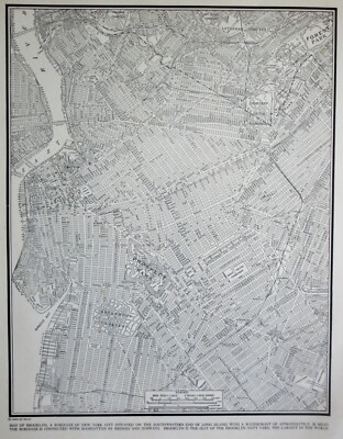
$5.75 Shipping Location: Malden, United States Beautiful Vintage 1942 Brooklyn Atlas City Map NYC New York City A Wonderful Gift! Great OLD Map from the"COLLIER'S WORLD ATLAS& GAZETTEER" ... moreCopyright 1942 71 Years Old! The Actual Page! NOT a Copy! Brooklyn, New York City. NY(Contact Us For More Scans) This Map Measures About 10 3/4 x 14 1/8" Map Shows Points of Interest. Brooklyn College. Parks, Cemetaeries, Bridges, Navy Yard, Naval Hospital, Parade Grounds. Etc. On The Back Is A Picture of The Empire State Building Very Educational. See what the City used to look like! It Will Look GREAT When Matted& Framed World War II Black& White A Nice Gift! A GREAT House Warming Gift! The Perfect Gift! It Will Look GREAT Matted& Framed Teachers& Politicians LOVE Them! Super For a Local Business or Office! Shipping by 1st Class Mail We Will Combine Shipping on Up To 4 Maps for the same shipping fee Email Us With Any Questions or For an International Shipping Quote Check out my other items! Be sure to add me to your favorites list! Thanks For Looking! International Buyers– Please Note: Import duties. Taxes, and charges are not included in the item price or shipping cost. These charges are the buyer's responsibility. Please check with your country's customs office to determine what these additional costs will be prior to bidding or buying. Certain images and/or photos used in this template are the copyrighted property of JupiterImages and are being used with permission under license.

Buy It Now
$5.75 Shipping Location: Malden, United States Vintage 1940 WWII World Atlas City Map Rochester NY OLD New York A Fantastic Christmas Gift! Great Genealogical Source! Great OLD Map from the"COLLIER'S ... moreWORLD ATLAS& GAZETTEER" Copyright 1940 73 Years Old! The Actual Page! NOT a Copy! The Business Center of Rochester. New York(Contact Us For More Scans) This Map Measures About 10 3/4 x 14 1/8" Map Shows Points of Interest. Schools, Masonic Temple, Parks, Churches, Public Bath, Eastman Kodak Factory, Theatres, Many Businesses With The Names, Hotels, Hardware Store Etc. Very Educational. See what the City used to look like! WWII Black& White Will look great Matted& framed A Nice Gift! A GREAT House Warming Gift! The Perfect Anytime Gift! Teachers& Politicians LOVE Them! Super For a Local Business or Office! We Have Many Maps From This Era.Ask Us Shipping by 1st Class or Priority Mail We Will Combine Shipping on Up To 4 Maps for the same shipping fee After Ordering. We will send an Invoice Email Us With Any Questions or For an International Shipping Quote Check out my other items! Be sure to add me to your favorites list! Thanks For Looking! International Buyers– Please Note: Import duties. Taxes, and charges are not included in the item price or shipping cost. These charges are the buyer's responsibility. Please check with your country's customs office to determine what these additional costs will be prior to bidding or buying.
Buy It Now
$4.99 Shipping Location: Fairview, United States It was published inCollier's World Atlas and Gazetteer, New York, 1937, a copy of the title page is included for authenticity. Condition: It is in Very ... moreGood to Excellent condition for its age, very clean on strong flexible paper, text on reverse.
$25.00 Shipping Location: Perugia, Italy Thomas Letts (1803 – 1873) was an English stationer and printer who popularised the diary. Published by Letts, Son & Co. Limited. Most of the plates used ... morefor this atlas were original engraved for the SDUK atlas in the mid nineteenth century.
Buy It Now
$4.99 Shipping Location: Fairview, United States There is also a map on the reverse. The pics are of the actual map.
Buy It Now
$5.75 Shipping Location: Malden, United States Rochester, NY. NEW ENCYCLOPEDIC ATLAS & GAZETTEER of The WORLD". 120 Years Old! Great OLD Map from the "COLLIER'S. Very Educational. See what the City ... moreused to look like! Map Shows Points of Interest.
Buy It Now
$13.71 Shipping Location: MANCHESTER, United Kingdom He based his atlases on the plates used by Edward Weller for his Weekly Dispatch Atlas. This interesting map is an original antique which is over 110 ... moreyears old.
Buy It Now
$11.85 Shipping Location: Dover, United States Wards and Senate Districts. Wards and Congressional Districts. Wards and School Districts. Wards and Justices Districts. Map of the City of New York, ... moreShowing its Political Divisions and Subdivisions, August 1869.
Buy It Now
$22.78 Shipping Location: Dover, United States One other fold line splitting (with Bushwick Ward) with archival tape repairs on reverse. Map of the Consolidated City of Brooklyn. Scarce and wonderful ... moremid 19th century lithographed urban plan, with original hand color.
Buy It Now
$5.99 Shipping Location: Lynbrook, United States 1944 folder, black sleeve.
Buy It Now
$5.00 Shipping Location: Canada DATE OF ISSUE: 1951.
Buy It Now
$4.99 Shipping Location: Fairview, United States It is from an 1891 German edition of a Rand, McNally & Co.,Neuer Familien-Atlas de Welt (New Family Atlas of the World), a copy of the title page is included. ... moreThe map halves were printed on separate pages and have been joined along the centerfold.
Buy It Now
$5.75 Shipping Location: Malden, United States Beautiful Antique 1924 Upper Manhattan And The Bronx Atlas City Map NYC. Great OLD Map from the "COLLIER'S WORLD ATLAS & GAZETTEER". New Yorkers, Teachers, ... moreStudents, Parents, Artists, Musicians, Travel Agents, Tourists, Historians, Real Estate Agents, Authors, Interior Decorators & Politicians LOVE Them!
Buy It Now
$4.99 Shipping Location: Fairview, United States It was published inCollier's World Atlas and Gazetteer, New York, 1937, a copy of the title page is included for authenticity. Condition: It is in Very ... moreGood to Excellent condition for its age, very clean on strong flexible paper, text on reverse.
$6.00 Shipping Location: Blue Bell, United States THIS MAP IS IN GOOD CONDITION AND PUBLISHED BY MATTHEWS-NORTHRUP. CONDITION: MAP IS IN GOOD. OVER 100 YEARS OLD! Over 100,000,000 served. MULTIPLE WINS.
Buy It Now
$5.75 Shipping Location: Malden, United States Great OLD Map from the "COLLIER'S WORLD ATLAS & GAZETTEER". Teachers, Students, Parents, Historians, Artists, Musicians, Authors, Real Estate Agents, ... moreTravel Agents, Tourists, Interior Decorators & Politicians LOVE Them!
Buy It Now
Free Shipping Location: Augusta, United States "An Authentic Original Map Not A Reproduction".
Buy It Now
$4.99 Shipping Location: Fairview, United States It is fromCollier's World Atlas and Gazetteer, New York, 1937, a copy of the title page is included for authenticity. Condition: It is in Very Good condition ... morefor its age, very clean on strong flexible paper, a similar style map on reverse.
Buy It Now
$4.99 Shipping Location: Fairview, United States It has strong color printed on paper that is still very bright. Condition: The map is in Good to Very Good condition with a similar state map on the reverse. ... moreThe pics are of the actual map. An Authentic Antique Map: Not a Modern Reproduction!
Buy It Now
$4.99 Shipping Location: Fairview, United States Land Book of the Borough of Manhattan City of New York, published in New York by Bromley & co., 1934. A facsimile copy of the title page will also be ... moreincluded for authenticity. An Authentic Antique Map: Not a Modern Reproduction!
Buy It Now
$4.99 Shipping Location: Fairview, United States Lake Erie Maps& Prints! An Authentic Antique Map: Not a Modern Reproduction! Click here for more! Free Shipping on Purchases of 5 or More Maps and ... morePrints Description: It is an original antique map from G.W. Bromley's Land Book of the Borough of Manhattan City of New York. Published in New York by Bromley& co. 1921. A facsimile copy of the title page will also be included for authenticity. The maps were mainly used by developers and real estate agents who periodically would receive updates of the building changes such as ownership or new structures that were issued as small cutouts that were then glued to update the map thus giving the map a unique character over time. It is handcolored probably with the use of stencils typical of the period. We have currenly listed many additional plates, click here New York City Maps. Please Note: There are two maps printed back to back on one sheet so if framing one would need to chose a side. It is not mounted. Matted nor framed, being sold as shown in the main pic. Size: The map image measures approximately 10 by 15 inches(25x38cm) on a 11 1/2 by 16 1/4" 29x41cm) page with a margin all around for framing as seen in the pic. Condition: The map is in Very Good overall condition with original hand coloring. There is light tonal ageing. Darkening around the edges, crimping along the binding edge, see the pics for more on condition. Overall, it is very clean with bright hand coloring that would frame up nicely. The pics are of the actual map. Payment Details: We accept most major credit cards through Paypal and Ebay. Please ask if you have any questions about payment. International and New Bidders are welcomed and encouraged. Payment is expected within 7 days. After which Nonpaying Bidders will be reported to Ebay to recoup our listing fees. Save on Shipping: We only charge one shipping fee based on the largest map or print with multiple items shipped along with it for no extra costs. Purchase 5 or more maps or prints and receive Free First Class shipping in USA o
Buy It Now
$6.95 Shipping Location: Dover, United States Original 19th century antique wood engraved image. An actual printed leaf taken from this scarce old periodical, published at the date listed. Issued ... moreFebruary 19th, 1876, New York, by Harper & Brothers.
Buy It Now
$7.00 Shipping Location: Rockville, United States Up for sale is a great, original, hand-colored, ANTIQUE MAP from MITCHELL'S NEW GENERAL ATLAS - 1880. Published by S. Augustus Mitchell, Philadelphia: ... more1880. TITLE: COUNTY MAP OF THE STATE OF NEW YORK.
Buy It Now
$6.95 Shipping Location: Dover, United States Issued 1871, New York. by Hayward for Valentine. A Map of the Common Lands Between the Three and Six Mile Stones Belonging to the Corporation of the City ... moreof New York, 1796. Left blank edge uneven and slightly narrow as issued from inset tab.
Buy It Now
$6.95 Shipping Location: Dover, United States Issued 1902, Chicago by George Cram. Early 20th century color lithographed map. Original center fold as issued.
Buy It Now
$9.00 Shipping Location: Cambridge, United States From "Hammond's New Era Atlas of the World" Hardcover XL Book 1909 first edition. In great condition with normal and typical wear. See pic for more detail. ... moreYour opinion may differ.

Buy It Now
$4.99 Shipping Location: Fairview, United States Click Here. Double your traffic. Get Vendio Gallery- Now FREE! Lake Erie Maps& Prints! An Authentic Antique Map: Not a Modern Reproduction! See Our ... moreEbay Store for More! Free Shipping on Purchases of 5 or More Maps and Prints Description: It is an authentic antique lithographic map approximately 98 years old with printed color. It is from an 1914 edition of Rand McNally's New Ideal Atlas(New York: Harper. 1914) a copy of the title page is included for authenticity. It is not matted nor framed being sold as a single sheet as shown in the main pic. There is also a map on the reverse. Overall, a very nice map that would frame up well. Size: The dimensions of the map area between the neat lines measures 9 1/4 by 12 3/4 inches(24x33cm) on a page measuring 11 by 14" 28x36cm) with a margin all around as seen in the main pic. Condition: The map is in Very Good to Excellent condition with very light tonal aging. Very clean. It is basically as seen in the pics, see the pic for more on condition. The pics are of the actual map. Payment Details: We accept most major credit cards through Paypal and Ebay. Please ask if you have any questions about other forms of payment. International and New Bidders are welcomed and encouraged. Payment is expected within 7 days. After which Nonpaying Bidders will be reported to Ebay to recoup our listing fees. Shipping: $2.90 for First Class or $4.95 for Priority Mail with Delivery Confirmation in the USA. $2.90 for First Class International to Canada; $6.00 for International Airmail elsewhere in the World. We ship daily, so if still bidding send us a quick email to hold or better just pay all at once at the end. Save on Shipping: We only charge one shipping fee based on the largest map or print with multiple items shipped along with it for no extra costs. Purchase 5 or more maps or prints and receive Free First Class shipping in USA or First Class International elsewhere in the world. Although registration may be required on shipments of high value. International Customs and VAT
Buy It Now
$4.99 Shipping Location: Fairview, United States Desk Atlas Borough of Brooklyn City of New York, by E. Belcher Hyde Map Co., Inc: New York, 1929. A facsimile copy of the title page will also be included ... morefor authenticity. Condition: The map is in Good overall condition, basically as seen in the pic.
Buy It Now
$5.75 Shipping Location: Montgomery, United States I believe this was given out the first year of the New York World's Fair, as it was amongst an estate-found collection of fair-related material. Mistakes ... morehappen.

Buy It Now
$4.99 Shipping Location: Fairview, United States Click Here. Double your traffic. Get Vendio Gallery- Now FREE! Lake Erie Maps& Prints! An Authentic Antique Map: Not a Modern Reproduction! See Our ... moreEbay Store for other! Free Shipping on Purchases of 5 or More Maps and Prints Description: It is an original engraved antique map approximately 125 years old with original hand coloring and a centerfold as issued. It is from Bradley's Atlas of the World published in Philadelphia by William Bradley& Bro. 1887. A facsimile copy of the title page will also be included for authenticity. The map is not mounted, matted nor framed, being sold as a large double page elephant size folio sheet as shown in the main pic. Overall, a beautiful map with nice color very well preserved. Size: The map image measures approximately 16 1/2 by 22 1/2 inches on a 19 by 26" 42x66cm) page with a margin all around for framing as seen in the pic. Condition: The map is in Excellent condition with original hand coloring and a centerfold as issued. Blank on the reverse, very clean with no distracting defects to mention, see the pics for more on condition. Overall, a very nice map printed on heavy paper in great shape with an antique appearance that would frame up nicely. The pics are of the actual map. Payment Details: We accept most major credit cards through Paypal and Ebay. Please ask if you have any questions about payment. International and New Bidders are welcomed and encouraged. Payment is expected within 7 days. After which Nonpaying Bidders will be reported to Ebay to recoup our listing fees. Shipping: $3.50 for First Class or $4.95 for Priority Mail with Delivery Confirmation in the USA; $5.95 for First Class International to Canada; $10 for International Airmail elsewhere in the World. We ship daily. So if still bidding send us a quick email to hold or better just pay all at once at the end. Save on Shipping: We only charge one shipping fee based on the largest map or print with multiple items shipped along with it for no extra costs. Purchase 5 or more maps or prints a
Buy It Now
Free Shipping Location: Carefree, United States ORIGINAL 1899 COLOR MAP OF THE STATE OF SOUTHERN NEW YORK AND NEW YORK CITY. VERY DETAILED AND NICELY COLORED ANTIQUE MAP WITH SOUTHERN NEW YORK AT TOP ... moreAND VICINITY OF NEW YORK CITY AT BOTTOM. DATED-1897 BELOW TITLE.
Buy It Now
$6.95 Shipping Location: Dover, United States Issued 1948, New York by the State of New York.
Buy It Now
$6.95 Shipping Location: Dover, United States Late 19th century color lithographed city plan. New York City (Northern & Southern Part). Many piers are also identified as to what specific lines are ... moreusing them.
Buy It Now
$4.99 Shipping Location: Fairview, United States World Atlas and Gazetteer, as stated in the top margin. It is from Rand McNally's. A great accent map with nice blues and greens! Condition: The map is ... morein Good condition. The pics are of the actual map.
Buy It Now
$4.99 Shipping Location: Fairview, United States It has strong color printed on paper that is still very bright. Condition: The map is in Good to Very Good condition with a similar state map on the reverse. ... moreThe pics are of the actual map. An Authentic Antique Map: Not a Modern Reproduction!
Buy It Now
$4.99 Shipping Location: Fairview, United States Land Book of the Borough of Manhattan City of New York, published in New York by Bromley & co., 1955. A facsimile copy of the title page will also be ... moreincluded for authenticity. There are a couple of updates on most of these map that are not obvious unless you look for them.
Buy It Now
Free Shipping Location: Sayville, United States See photo's.
Buy It Now
$4.99 Shipping Location: Fairview, United States There is text on the reverse. Condition: The map is in Very Good condition with light tonal ageing, otherwise it is very clean, see the pics for more ... moreon condition. The pics are of the actual map. An Original Antique Map: Not a Reproduction!
Buy It Now
$4.99 Shipping Location: Fairview, United States Land Book of the Borough of Manhattan City of New York, published in New York by Bromley & co., 1934. A facsimile copy of the title page will also be ... moreincluded for authenticity. Condition: The map is in Fair to Good overall condition.
Buy It Now
$4.99 Shipping Location: Fairview, United States Land Book of the Borough of Manhattan City of New York, published in New York by Bromley & co., 1955. A facsimile copy of the title page will also be ... moreincluded for authenticity. An Authentic Antique Map: Not a Modern Reproduction!
Buy It Now
$5.00 Shipping Location: Canada DATE OF ISSUE: 1951.
Buy It Now
$5.75 Shipping Location: Malden, United States Antique 1924 World War I Era Atlas City Map of. Lower Manhattan, New York City. The New York Map Shows. Great, Inexpensive, Antique Wall Art! U.S. Navy ... moreYard, Bridges, Tunnels, Ferries, Hospitals, Islands, The Lower Half of Central Park, Freight Yards, Etc.
$6.00 Shipping Location: Blue Bell, United States THIS MAP IS IN GOOD CONDITION AND PUBLISHED BY MATTHEWS-NORTHRUP. CONDITION: MAP IS IN GOOD. OVER 100 YEARS OLD! Over 100,000,000 served. MULTIPLE WINS.
Buy It Now
$4.99 Shipping Location: Fairview, United States Land Book of the Borough of Manhattan City of New York, published in New York by Bromley & co., 1955. A facsimile copy of the title page will also be ... moreincluded for authenticity. It is handcolored probably with the use of stencils typical of the period.
Buy It Now
Free Shipping Location: Schertz, United States This Map was removed from a 1938 Pictorial Atlas and is in good acceptable condition. The map is not " new " or in " new " condition, it was printed in ... more1938. The map is not dated. Study the photos carefully, this is the actual map you will receive.
Buy It Now
Free Shipping Location: Schertz, United States This antique map from 1863 depicts the New York City area and surrounding regions. Measuring 18x27 inches, it is an original map by Johnson & Ward from ... morethe Civil War period, making it over 150 years old. The map is in good condition and comes with free shipping within the USA, with calculated shipping available worldwide. Please note that the title page is not included, it is for reference purposes only.
Buy It Now
$4.99 Shipping Location: Fairview, United States New Indexed Family Atlas, published by Gaylord Watson, New York, 1882, a copy of the title page is included for authenticity. It is from Watson's. An ... moreAuthentic Antique Map: Not a Modern Reproduction!
Buy It Now
$4.99 Shipping Location: Fairview, United States It is fromThe Eclectic Complete Geography, 1896, a copy of the title page is included. An Authentic Antique Map: Not a Modern Reproduction! Condition: ... moreIt is in Good condition for its age, with text on the reverse and overall light tonal ageing.
Buy It Now
$4.99 Shipping Location: Fairview, United States Land Book of the Borough of Manhattan City of New York, published in New York by Bromley & co., 1955. A facsimile copy of the title page will also be ... moreincluded for authenticity. There are a couple of updates on most of these map that are not obvious unless you look for them.
Buy It Now
$6.00 Shipping Location: Canada DATE OF ISSUE: 1902.
Buy It Now
Free Shipping Location: Schertz, United States This antique map from 1887 showcases New York City and Brooklyn in stunning detail, with a size of 15x24. The hand-tinted highlights add a unique touch ... moreto this piece, which is over 130 years old. The cartographer/publisher of this map is M. Bradley / S. A. Mitchell and it is an original piece. The city aspect of the map focuses on Brooklyn, while the year of publication is indicated to be 1887. In terms of shipping, free S&H is available in the USA, while calculated S&H is available for worldwide delivery. The map cover is not included for sale and is only for reference purposes.
Buy It Now
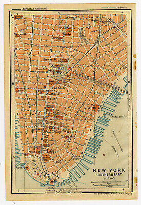
$14.95 Shipping Location: Netherlands ABOUT US VISIT OUR STORE SALES SPECIALS Antique Map-NEW YORK-CITY HALL PARK-USA-Karl Baedeker-Wagner& Debes-1904 Description: This plate originates ... morefrom: The United States with excursions to Mexico. Cuba, Porto Rico, and Alaska. Hnadbook for travellers by Karl Baedeker. 4 th ed. published in Leipzig, New York and London, 1909. Maps by Wagner& Debes, Leipzig. Artists and Engravers: Karl Baedeker(1801-1859) was a German publisher whose company'Verlag Karl Baedeker' set the standard for authoritative guidebooks for tourists. Subject: Map/ plan: New York. Southern part' New York with City Hall, Battery Park and Brooklyn Bridge. Condition: Excellent. General age related toning. Please study scan carefully. Size(in cm) The overall size is ca. 10.5 x 16 cm. The image size is ca. 10 x 14.5 cm. Size(in inch) The overall size is ca. 4.1 x 6.3 inch. The image size is ca. 3.9 x 5.7 inch. Medium: Colour lithograph. Location: C174-04 ThePrintsCollector Peter Cornelissen. Margo van Latum- van Dongen, Frank van Latum Zeeland- The Netherlands Phone: +31 654 21 23 78 Worldwide free shipping on all orders. We ship within one business day upon receipt of payment. We ship by Registered Mail. Insurance is included. We guarantee our items to be genuine original. Visit our Store: we would like to invite you to review similar items in our Store or to browse through all other items in our Store. We are confident that you will find very special unique antique maps and prints in our Store. It is our privilege to have you as a customer. We accept Paypal payments and payment by bank transfer. Combined auction/ buy it now orders are possible! We will send a Paypal invoice on request! THE PRINTSCOLLECTOR GUARANTEES ITEMS SOLD THROUGH EBAY ARE GENUINE ORIGINAL ANTIQUE PRINTS IN THE CONDITION/TECHNIC AS DESCRIBED. ITEMS CAN BE RETURNED WITHIN 7 DAYS. Powered by
Buy It Now
$6.95 Shipping Location: Dover, United States Perfect for gift giving.
|
|
|
In
|
Vintage 1940 World War II Atlas City Map Buffalo, NY, New York WWII Great Gift!
Vintage 1940 World Atlas City Map Buffalo. NY, New York A Wonderful Gift! Great OLD Map from the"COLLIER'S WORLD ATLAS& GAZETTEER" Copyright 1940 73 Years Old! The Actual Page! NOT a Copy! Buffalo. NY(Contact Us For More Scans) This Map Measures About 10 3/4 x 14 1/8" Map Shows Points of Interest. The Niagara River, Buffalo State Normal School, Buffalo State Hospital, Reservoir, Pullman Palace Car Works, City Hall, Central Station, Railroads, University of Buffalo,Grover Cleveland Park, Ford Motor Car Co. Stock Yards, 106th Armory, Etc. On The Back Is a Photo Of The Hassan Refa Mosque in Cairo. Egypt Very Educational. See what the City used to look like! WWII Black& White It Will look GREAT Matted& Framed A Nice Gift! A GREAT House Warming Gift! The Perfect Anytime Gift! Teachers& Politicians LOVE Them! ... moreSuper For a Local Business or Office! Shipping by 1st Class Mail We Will Combine Shipping on Up To 4 Maps for the same shipping fee Email Us With Any Questions or For an International Shipping Quote Check out my other items! Be sure to add me to your favorites list! Thanks For Looking! International Buyers– Please Note: Import duties. Taxes, and charges are not included in the item price or shipping cost. These charges are the buyer's responsibility. Please check with your country's customs office to determine what these additional costs will be prior to bidding or buying. Certain images and/or photos used in this template are the copyrighted property of JupiterImages and are being used with permission under license.
|
|
|
Vintage 1924 Upper Manhattan Bronx Atlas Map NY New York City World War WWI Era
Vintage 1924 Upper Manhattan& Bronx Atlas City Map NYC New York City A Wonderful Gift! Great OLD Map from the"COLLIER'S THE NEW ENCYCLOPEDIC ATLAS& GAZETTEER OF THE WORLD" The Atlas Is Copyright 1924 89 Years Old! The Actual Page! NOT a Copy! Upper Manhattan& The Bronx. New York City, NY(Contact Us For More Scans) On the other side is The Index of Streets This Map Measures About 10 1/4 x 15 1/8" Map Shows Points of Interest. The East, The Harlem& The Hudson Rivers, Emigrant Hospital, The University of The City of New York, Central Park, The Bronx, Polo Grounds, Ball Grounds, Columbia University, Convent of The Sacred Heart, Deaf and Dumb Institute, Fort George, New York& Harlem Railroad, Hells Gate, Etc. Very Educational. See what the City used to look like! On The Back There Is a Guide To Streets In ... moreNorthern& Southern Manhattan. Points of Interest& Piers It Will Look GREAT When Matted& Framed Post World War I Black& White A Nice Gift! A GREAT House Warming Gift! The Perfect Gift! It Will Look GREAT Matted& Framed This Map Can Line Up& Be Framed With The"Lower Manhattan" Map From The Same Year! Teachers& Politicians LOVE Them! Super For a Local Business or Office! Shipping by 1st Class Mail We Will Combine Shipping on Up To 4 Maps for the same shipping fee Email Us With Any Questions or For an International Shipping Quote Check out my other items! Be sure to add me to your favorites list! Thanks For Looking! International Buyers– Please Note: Import duties. Taxes, and charges are not included in the item price or shipping cost. These charges are the buyer's responsibility. Please check with your country's customs office to determine what these additional costs will be prior to bidding or buying. Certain images and/or photos used in this template are the copyrighted property of JupiterImages and are being used with permission under license.
|
|
|
L@@K! Vintage 1944 Brooklyn Atlas Map NY New York City World War WWII Era
Beautiful Vintage 1944 Brooklyn Atlas City Map NYC New York City A Wonderful Gift! Great OLD Map from the"COLLIER'S WORLD ATLAS& GAZETTEER" Copyright 1944 69 Years Old! The Actual Page! NOT a Copy! Brooklyn, New York City. NY(Contact Us For More Scans) This Map Measures About 10 3/4 x 14 1/8" Map Shows Points of Interest. Brooklyn College. Parks, Cemetaeries, Bridges, Navy Yard, Naval Hospital, Parade Grounds. Etc. On The Back Is A Picture of The Empire State Building Very Educational. See what the City used to look like! It Will Look GREAT When Matted& Framed World War II Black& White A Nice Gift! A GREAT House Warming Gift! The Perfect Gift! It Will Look GREAT Matted& Framed Teachers& Politicians LOVE Them! Super For a Local Business or Office! Shipping by 1st Class Mail We Will Combine Shipping on ... moreUp To 4 Maps for the same shipping fee Email Us With Any Questions or For an International Shipping Quote Check out my other items! Be sure to add me to your favorites list! Thanks For Looking! International Buyers– Please Note: Import duties. Taxes, and charges are not included in the item price or shipping cost. These charges are the buyer's responsibility. Please check with your country's customs office to determine what these additional costs will be prior to bidding or buying. Certain images and/or photos used in this template are the copyrighted property of JupiterImages and are being used with permission under license.
|
|
|
Vintage 1943 World War WWII Atlas City Map Rochester NY New York With Businesses
Vintage 1943 WWII World Atlas City Map Rochester NY OLD New York A Fantastic Gift! Great Genealogical Source! Great OLD Map from the"COLLIER'S WORLD ATLAS& GAZETTEER" Copyright 1943 70 Years Old! The Actual Page! NOT a Copy! The Business Center of Rochester. New York(Contact Us For More Scans) This Map Measures About 10 3/4 x 14 1/8" Map Shows Points of Interest. Schools, Masonic Temple, Parks, Churches, Public Bath, Eastman Kodak Factory, Theatres, Many Businesses With The Names, Hotels, Hardware Store Etc. Very Educational. See what the City used to look like! WWII Black& White Will look great Matted& framed A Nice Gift! A GREAT House Warming Gift! The Perfect Anytime Gift! Teachers& Politicians LOVE Them! Super For a Local Business or Office! We Have Many Maps From This Era.Ask Us Shipping by 1st Class ... moreor Priority Mail We Will Combine Shipping on Up To 4 Maps for the same shipping fee After Ordering. We will send an Invoice Email Us With Any Questions or For an International Shipping Quote Check out my other items! Be sure to add me to your favorites list! Thanks For Looking! International Buyers– Please Note: Import duties. Taxes, and charges are not included in the item price or shipping cost. These charges are the buyer's responsibility. Please check with your country's customs office to determine what these additional costs will be prior to bidding or buying.
|
|
|
L@@K! Vintage 1944 Lower Manhattan Atlas Map NY New York City World War WWII Era
Beautiful Vintage 1944 Lower Manhattan Atlas City Map NYC New York City A Wonderful Gift! Great OLD Map from the"COLLIER'S WORLD ATLAS& GAZETTEER" Copyright 1944 RARE! 69 Years Old! The Actual Page! NOT a Copy! Lower Manhattan, New York City. NY(Contact Us For More Scans) This Map Measures About 10 3/4 x 14 1/8" Map Shows Points of Interest. Chinatown. City Hall, The Financial District, Jersey City, Hoboken, Tunnels, Ferries, Welfare Island, The Lower Half of Central ParkMadison Square. Etc. Very Educational. See what the City used to look like! It Will Look GREAT When Matted& Framed World War II Black& White A Nice Gift! A GREAT House Warming Gift! The Perfect Gift! It Will Look GREAT Matted& Framed This Map Can Line Up& Be Framed With The"Upper Manhattan" Map From The Same Year! Teachers& ... morePoliticians LOVE Them! Super For a Local Business or Office! Shipping by 1st Class Mail We Will Combine Shipping on Up To 4 Maps for the same shipping fee Email Us With Any Questions or For an International Shipping Quote Check out my other items! Be sure to add me to your favorites list! Thanks For Looking! International Buyers– Please Note: Import duties. Taxes, and charges are not included in the item price or shipping cost. These charges are the buyer's responsibility. Please check with your country's customs office to determine what these additional costs will be prior to bidding or buying. Certain images and/or photos used in this template are the copyrighted property of JupiterImages and are being used with permission under license.
|
|
|
L@@K! Vintage 1942 Brooklyn Atlas Map NY New York City World War WWII Era
Beautiful Vintage 1942 Brooklyn Atlas City Map NYC New York City A Wonderful Gift! Great OLD Map from the"COLLIER'S WORLD ATLAS& GAZETTEER" Copyright 1942 71 Years Old! The Actual Page! NOT a Copy! Brooklyn, New York City. NY(Contact Us For More Scans) This Map Measures About 10 3/4 x 14 1/8" Map Shows Points of Interest. Brooklyn College. Parks, Cemetaeries, Bridges, Navy Yard, Naval Hospital, Parade Grounds. Etc. On The Back Is A Picture of The Empire State Building Very Educational. See what the City used to look like! It Will Look GREAT When Matted& Framed World War II Black& White A Nice Gift! A GREAT House Warming Gift! The Perfect Gift! It Will Look GREAT Matted& Framed Teachers& Politicians LOVE Them! Super For a Local Business or Office! Shipping by 1st Class Mail We Will Combine Shipping on ... moreUp To 4 Maps for the same shipping fee Email Us With Any Questions or For an International Shipping Quote Check out my other items! Be sure to add me to your favorites list! Thanks For Looking! International Buyers– Please Note: Import duties. Taxes, and charges are not included in the item price or shipping cost. These charges are the buyer's responsibility. Please check with your country's customs office to determine what these additional costs will be prior to bidding or buying. Certain images and/or photos used in this template are the copyrighted property of JupiterImages and are being used with permission under license.
|
|
|
Vintage 1943 World War II Atlas City Map Buffalo, NY, New York WWII Great Gift!
Vintage 1943 World Atlas City Map Buffalo. NY, New York A Wonderful Gift! Great OLD Map from the"COLLIER'S WORLD ATLAS& GAZETTEER" Copyright 1943 70 Years Old! The Actual Page! NOT a Copy! Buffalo. NY(Contact Us For More Photos) This Map Measures About 10 3/4 x 14 1/8" Map Shows Points of Interest. The Niagara River, Buffalo State Normal School, Buffalo State Hospital, Reservoir, Pullman Palace Car Works, City Hall, Central Station, Railroads, University of Buffalo,Grover Cleveland Park, Ford Motor Car Co. Stock Yards, 106th Armory, Etc. Very Educational. See what the City used to look like! WWII Black& White It Will look GREAT Matted& Framed A Nice Gift! A GREAT House Warming Gift! The Perfect Anytime Gift! Teachers& Politicians LOVE Them! Super For a Local Business or Office! Shipping by 1st Class Mail ... moreWe Will Combine Shipping on Up To 4 Maps for the same shipping fee Email Us With Any Questions or For an International Shipping Quote Check out my other items! Be sure to add me to your favorites list! Thanks For Looking! International Buyers– Please Note: Import duties. Taxes, and charges are not included in the item price or shipping cost. These charges are the buyer's responsibility. Please check with your country's customs office to determine what these additional costs will be prior to bidding or buying. Certain images and/or photos used in this template are the copyrighted property of JupiterImages and are being used with permission under license.
|
|
|
Vintage 1940 World War WWII Atlas City Map Rochester NY New York With Businesses
Vintage 1940 WWII World Atlas City Map Rochester NY OLD New York A Fantastic Christmas Gift! Great Genealogical Source! Great OLD Map from the"COLLIER'S WORLD ATLAS& GAZETTEER" Copyright 1940 73 Years Old! The Actual Page! NOT a Copy! The Business Center of Rochester. New York(Contact Us For More Scans) This Map Measures About 10 3/4 x 14 1/8" Map Shows Points of Interest. Schools, Masonic Temple, Parks, Churches, Public Bath, Eastman Kodak Factory, Theatres, Many Businesses With The Names, Hotels, Hardware Store Etc. Very Educational. See what the City used to look like! WWII Black& White Will look great Matted& framed A Nice Gift! A GREAT House Warming Gift! The Perfect Anytime Gift! Teachers& Politicians LOVE Them! Super For a Local Business or Office! We Have Many Maps From This Era.Ask Us Shipping by ... more1st Class or Priority Mail We Will Combine Shipping on Up To 4 Maps for the same shipping fee After Ordering. We will send an Invoice Email Us With Any Questions or For an International Shipping Quote Check out my other items! Be sure to add me to your favorites list! Thanks For Looking! International Buyers– Please Note: Import duties. Taxes, and charges are not included in the item price or shipping cost. These charges are the buyer's responsibility. Please check with your country's customs office to determine what these additional costs will be prior to bidding or buying.
|
|
|
L@@K! Vintage 1943 Lower Manhattan Atlas Map NY New York City World War WWII Era
Beautiful Vintage 1943 Lower Manhattan Atlas City Map NYC New York City A Wonderful Christmas Gift! Great OLD Map from the"COLLIER'S WORLD ATLAS& GAZETTEER" Copyright 1943 RARE! 70 Years Old! The Actual Page! NOT a Copy! Lower Manhattan, New York City. NY(Contact Us For More Scans) This Map Measures About 10 3/4 x 14 1/8" Map Shows Points of Interest. Chinatown. City Hall, The Financial District, Jersey City, Hoboken, Tunnels, Ferries, Welfare Island, The Lower Half of Central ParkMadison Square. Etc. Very Educational. See what the City used to look like! It Will Look GREAT When Matted& Framed World War II Black& White A Nice Gift! A GREAT House Warming Gift! The Perfect Gift! It Will Look GREAT Matted& Framed This Map Can Line Up& Be Framed With The"Upper Manhattan" Map From The Same Year! ... moreTeachers& Politicians LOVE Them! Super For a Local Business or Office! Shipping by 1st Class Mail We Will Combine Shipping on Up To 4 Maps for the same shipping fee Email Us With Any Questions or For an International Shipping Quote Check out my other items! Be sure to add me to your favorites list! Thanks For Looking! International Buyers– Please Note: Import duties. Taxes, and charges are not included in the item price or shipping cost. These charges are the buyer's responsibility. Please check with your country's customs office to determine what these additional costs will be prior to bidding or buying. Certain images and/or photos used in this template are the copyrighted property of JupiterImages and are being used with permission under license.
|
|
|
Vintage 1940 Upper Manhattan Bronx Atlas Map NY New York City World War WWII Era
Vintage 1940 Upper Manhattan& Bronx Atlas City Map NYC New York City A Wonderful Gift! Great OLD Map from the"COLLIER'S WORLD ATLAS& GAZETTEER" Copyright 1940 73 Years Old! The Actual Page! NOT a Copy! Upper Manhattan& The Bronx. New York City, NY(Contact Us For More Scans) This Map Measures About 10 3/4 x 14 1/8" Map Shows Points of Interest. Yankee Stadium. The East, The Harlem& The Hudson Rivers, Hell Gate, The Botanical& Zoological Gardens, Central Park, The Bronx, Polo Grounds, Fordham University, Palisade AmusementPark, Etc. Very Educational. See what the City used to look like! On The back There Are Photos Of The Columbia Presbeyterian Medical Center& Rockefeller Center It Will Look GREAT When Matted& Framed World War II Black& White A Nice Gift! A GREAT House Warming Gift! The Perfect ... moreGift! It Will Look GREAT Matted& Framed This Map Can Line Up& Be Framed With The"Lower Manhattan" Map From The Same Year! Teachers& Politicians LOVE Them! Super For a Local Business or Office! Shipping by 1st Class Mail We Will Combine Shipping on Up To 4 Maps for the same shipping fee Email Us With Any Questions or For an International Shipping Quote Check out my other items! Be sure to add me to your favorites list! Thanks For Looking! International Buyers– Please Note: Import duties. Taxes, and charges are not included in the item price or shipping cost. These charges are the buyer's responsibility. Please check with your country's customs office to determine what these additional costs will be prior to bidding or buying. Certain images and/or photos used in this template are the copyrighted property of JupiterImages and are being used with permission under license.
|
|
|
Vintage 1919 Upper Manhattan Bronx Atlas Map NY New York City World War WWI Era
Vintage 1919 Upper Manhattan& Bronx Atlas City Map NYC New York City What A Wonderful Christmas Gift! Great OLD Map from the"COLLIER'S THE NEW ENCYCLOPEDIC ATLAS& GAZETTEER OF THE WORLD" The Atlas Is Copyright 1919 94 Years Old! The Map Is Copyright 1917 96 Years Old! The Actual Page! NOT a Copy! Upper Manhattan& The Bronx. New York City, NY(Contact Us For More Scans) On the other side is The Index of Streets For Upper& Lower Manhattan This Map Measures About 10 1/4 x 15 1/8" Map Shows Points of Interest. The East, The Harlem& The Hudson Rivers, Emigrant Hospital, The University of The City of New York, Central Park, The Bronx, Polo Grounds, Ball Grounds, Columbia University, Convent of The Sacred Heart, Deaf and Dumb Institute, Fort George, New York& Harlem Railroad, Hells Gate, Etc. Very Educational. ... moreSee what the City used to look like! On The Back There Is a Guide To Streets In Northern& Southern Manhattan. Points of Interest& Piers There Are Some Water Stains On The Bottom But They Are In The Margin They Can Be Hidden When Matted& Framed It Will Look GREAT When Matted& Framed World War I Era Black& White A Nice Gift! A GREAT House Warming Gift! The Perfect Gift! It Will Look GREAT Matted& Framed This Map Can Line Up& Be Framed With The"Lower Manhattan" Map From The Same Year! Teachers& Politicians LOVE Them! Super For a Local Business or Office! Shipping by 1st Class Mail We Will Combine Shipping on Up To 4 Maps for the same shipping fee Email Us With Any Questions or For an International Shipping Quote Check out my other items! Be sure to add me to your favorites list! Thanks For Looking! International Buyers– Please Note: Import duties. Taxes, and charges are not included in the item price or shipping cost. These charges are the buyer's responsibility. Please check with your country's customs office to determine what these additional costs will be prior to bidding or buying. Certain images and/or photos used in this
|
|
|
Vintage 1917 Upper Manhattan Bronx Atlas Map NY New York City World War WWI Era
Vintage 1917 Upper Manhattan& Bronx Atlas City Map NYC New York City What A Wonderful Christmas Gift! Great OLD Map from the"COLLIER'S THE NEW ENCYCLOPEDIC ATLAS& GAZETTEER OF THE WORLD" The Atlas Is Copyright 1917 96 Years Old! The Map Is Copyright 1908 105 Years Old! The Actual Page! NOT a Copy! Upper Manhattan& The Bronx. New York City, NY(Contact Us For More Scans) On the other side is The Index of Streets For Upper& Lower Manhattan. Points of Interest& Piers in Manhattan This Map Measures About 10 1/4 x 15 1/8" Map Shows Points of Interest. The East, The Harlem& The Hudson Rivers, Emigrant Hospital, The University of The City of New York, Central Park, The Bronx, Polo Grounds, Ball Grounds, Columbia University, Convent of The Sacred Heart, Deaf and Dumb Institute, Fort George, New York& ... moreHarlem Railroad, Hells Gate, Etc. Very Educational. See what the City used to look like! On The Back There Is a Guide To Streets In Northern& Southern Manhattan. Points of Interest& Piers It Will Look GREAT When Matted& Framed World War I Era Black& White A Nice Gift! A GREAT House Warming Gift! The Perfect Gift! It Will Look GREAT Matted& Framed Teachers& Politicians LOVE Them! Super For a Local Business or Office! Shipping by 1st Class Mail We Will Combine Shipping on Up To 4 Maps for the same shipping fee Email Us With Any Questions or For an International Shipping Quote Check out my other items! Be sure to add me to your favorites list! Thanks For Looking! International Buyers– Please Note: Import duties. Taxes, and charges are not included in the item price or shipping cost. These charges are the buyer's responsibility. Please check with your country's customs office to determine what these additional costs will be prior to bidding or buying. Certain images and/or photos used in this template are the copyrighted property of JupiterImages and are being used with permission under license.
|
|
|
Vintage 1937 Upper Manhattan Bronx Atlas Map NY New York City World War WWII Era
Vintage 1937 Upper Manhattan& Bronx Atlas City Map NYC New York City A Wonderful Gift! Great OLD Map from the"COLLIER'S WORLD ATLAS& GAZETTEER" Copyright 1937 77 Years Old! The Actual Page! NOT a Copy! Upper Manhattan& The Bronx. New York City, NY(Contact Us For More Photos) This Map Measures About 10 3/4 x 14 1/8" Map Shows Points of Interest. Yankee Stadium. The East, The Harlem& The Hudson Rivers, Hell Gate, The Botanical& Zoological Gardens, Central Park, The Bronx, Polo Grounds, Fordham University, Palisade AmusementPark, Etc. Very Educational. See what the City used to look like! On The back There Are Photos Of The New York Medical Center& Rockefeller Center It Will Look GREAT When Matted& Framed World War II ERA Black& White A Nice Gift! A GREAT House Warming Gift! The Perfect Gift! ... moreIt Will Look GREAT Matted& Framed This Map Can Line Up& Be Framed With The"Lower Manhattan" Map From The Same Year! Ask Us If We Have The Map of The Same Year If It Is Not Listed Teachers& Politicians LOVE Them! Super For a Local Business or Office! Shipping by 1st Class Mail We Will Combine Shipping on Up To 4 Maps for the same shipping fee Email Us With Any Questions or For an International Shipping Quote Check out my other items! Be sure to add me to your favorites list! Thanks For Looking! International Buyers– Please Note: Import duties. Taxes, and charges are not included in the item price or shipping cost. These charges are the buyer's responsibility. Please check with your country's customs office to determine what these additional costs will be prior to bidding or buying. Certain images and/or photos used in this template are the copyrighted property of JupiterImages and are being used with permission under license.
|
|
|
L@@K! Vintage 1941 Lower Manhattan Atlas Map NY New York City World War WWII Era
Beautiful Vintage 1941 Lower Manhattan Atlas City Map NYC New York City A Wonderful Gift! Great OLD Map from the"COLLIER'S WORLD ATLAS& GAZETTEER" Copyright 1941 RARE! 73 Years Old! The Actual Page! NOT a Copy! Lower Manhattan, New York City. NY(Contact Us For More Scans) This Map Measures About 10 3/4 x 14 1/8" Map Shows Points of Interest. Chinatown. City Hall, The Financial District, Jersey City, Hoboken, Tunnels, Ferries, Welfare Island, The Lower Half of Central ParkMadison Square. Etc. Very Educational. See what the City used to look like! It Will Look GREAT When Matted& Framed World War II Black& White A Nice Gift! A GREAT House Warming Gift! The Perfect Gift! It Will Look GREAT Matted& Framed This Map Can Line Up& Be Framed With The"Upper Manhattan" Map From The Same Year! Ask Us If ... moreWe Have The Map From The Same Year If It Is Not Listed Teachers& Politicians LOVE Them! Super For a Local Business or Office! Shipping by 1st Class Mail We Will Combine Shipping on Up To 4 Maps for the same shipping fee Email Us With Any Questions or For an International Shipping Quote Check out my other items! Be sure to add me to your favorites list! Thanks For Looking! International Buyers– Please Note: Import duties. Taxes, and charges are not included in the item price or shipping cost. These charges are the buyer's responsibility. Please check with your country's customs office to determine what these additional costs will be prior to bidding or buying.
|
|
|
L@@K Antique 1914 World War I Atlas City Map Buffalo NY New York WWI Great Gift!
Antique 1914 World Atlas City Map Buffalo. NY, New York A Wonderful Gift! Great OLD Map from the COLLIER'S"NEW ENCYCLOPEDIC ATLAS& GAZETTEER OF THE WORLD" Copyright 1914 100 Years Old! The Actual Page! NOT a Copy! Buffalo. NY(Contact Us For More Photos) This Map Measures About 9" x 12" The Page Measures About 10 1/4" x 15 1/8" Map Shows Points of Interest. Lake Erie, The Niagara River, Erie County Hospital, New York State Hospital, Providence Retreat, U.S. Life Saving Station, City Hall, Post Office, Court House, Railroad Depots, Fair Ground, Parks, Lighthouses, Squaw Island, Lehigh Valley Railroad Coal Docks, Etc. Very Educational. See what the City used to look like! WWI Black& White It Will look GREAT Matted& Framed See All Photos A Nice Gift! A GREAT House Warming Gift! The Perfect Anytime ... moreGift! Teachers& Politicians LOVE Them! Super For a Local Business or Office! If You Purchase More Than 1 Map. Wait Until We Send You a Revised Invoice With 1 Shipping Fee Shipping by 1st Class or Priority Mail We Will Combine Shipping on Up To 4 Maps for the same shipping fee Email Us With Any Questions or For an International Shipping Quote Check out my other items! Be sure to add me to your favorites list! Thanks For Looking! International Buyers– Please Note: Import duties. Taxes, and charges are not included in the item price or shipping cost. These charges are the buyer's responsibility. Please check with your country's customs office to determine what these additional costs will be prior to bidding or buying. Certain images and/or photos used in this template are the copyrighted property of JupiterImages and are being used with permission under license.
|
|
|
L@@K! Vintage 1943 Brooklyn Atlas Map NY New York City World War WWII Era
Beautiful Vintage 1943 Brooklyn Atlas City Map NYC New York City A Wonderful Christmas Gift! Great OLD Map from the"COLLIER'S WORLD ATLAS& GAZETTEER" Copyright 1943 70 Years Old! The Actual Page! NOT a Copy! Brooklyn, New York City. NY(Contact Us For More Scans) This Map Measures About 10 3/4 x 14 1/8" Map Shows Points of Interest. Brooklyn College. Parks, Cemetaeries, Bridges, Navy Yard, Naval Hospital, Parade Grounds. Etc. On The Back Is A Picture of The Empire State Building Very Educational. See what the City used to look like! It Will Look GREAT When Matted& Framed World War II Black& White A Nice Gift! A GREAT House Warming Gift! The Perfect Gift! It Will Look GREAT Matted& Framed Teachers& Politicians LOVE Them! Super For a Local Business or Office! Shipping by 1st Class Mail We Will Combine Shipping ... moreon Up To 4 Maps for the same shipping fee Email Us With Any Questions or For an International Shipping Quote Check out my other items! Be sure to add me to your favorites list! Thanks For Looking! International Buyers– Please Note: Import duties. Taxes, and charges are not included in the item price or shipping cost. These charges are the buyer's responsibility. Please check with your country's customs office to determine what these additional costs will be prior to bidding or buying. Certain images and/or photos used in this template are the copyrighted property of JupiterImages and are being used with permission under license.
|
|
|
Vintage 1942 World War WWII Atlas City Map Rochester NY New York With Businesses
Vintage 1942 WWII World Atlas City Map Rochester NY OLD New York A Fantastic Gift! Great Genealogical Source! Great OLD Map from the"COLLIER'S WORLD ATLAS& GAZETTEER" Copyright 1942 72 Years Old! The Actual Page! NOT a Copy! The Business Center of Rochester. New York(Contact Us For More Photos) This Map Measures About 10 3/4 x 14 1/8" Map Shows Points of Interest. Schools, Masonic Temple, Parks, Churches, Public Bath, Eastman Kodak Factory, Theatres, Many Businesses With The Names, Hotels, Hardware Store Etc. Very Educational. See what the City used to look like! WWII Black& White There Is a Small Area With Foxing. Brown Spots, Near The Intersection of North St. University(Photo# 6) There Is Also a Small Tear In The Bottom Left Margin Which Can Be Hidden When Matted& Framed It Will Look Great Matted& Framed! ... moreA Really Nice Gift! A GREAT House Warming Gift! The Perfect Anytime Gift! Teachers& Politicians LOVE Them! Super For a Local Business or Office! We Have Many Maps From This Era.Ask Us Shipping by 1st Class or Priority Mail We Will Combine Shipping on Up To 4 Maps for the same shipping fee After Ordering. We will send an Invoice Email Us With Any Questions or For an International Shipping Quote Check out my other items! Be sure to add me to your favorites list! Thanks For Looking! International Buyers– Please Note: Import duties. Taxes, and charges are not included in the item price or shipping cost. These charges are the buyer's responsibility. Please check with your country's customs office to determine what these additional costs will be prior to bidding or buying. RcmdId ViewItemDescV4,RlogId p4%60bo7%60jtb9%3Fvo%7B2d71f%2Bb41%3E-143d11129bf-0xec-
|
|
|
Vintage 1926 Upper Manhattan, Bronx Atlas Map NY New York City World War WWI Era
Vintage 1926 Upper Manhattan& Bronx Atlas City Map NYC New York City What A Wonderful Gift! Great OLD Map from the"COLLIER'S THE NEW ENCYCLOPEDIC ATLAS& GAZETTEER OF THE WORLD" The Atlas Is Copyright 1926 88 Years Old! The Actual Page! NOT a Copy! Upper Manhattan& The Bronx. New York City, NY(Contact Us For More Photos) On the other side is The Index of Streets For Upper& Lower Manhattan. Points of Interest& Piers in Manhattan This Map Measures About 10 1/4 x 15 1/8" Map Shows Points of Interest. The East, The Harlem& The Hudson Rivers, Emigrant Hospital, The University of The City of New York, Central Park, The Bronx, Polo Grounds, Ball Grounds, Columbia University, Convent of The Sacred Heart, Deaf and Dumb Institute, Fort George, New York& Harlem Railroad, Hells Gate, Etc. Very Educational. ... moreSee what the City used to look like! On The Back There Is a Guide To Streets In Northern& Southern Manhattan. Points of Interest& Piers It Will Look GREAT When Matted& Framed! World War I Era Black& White A Really Nice Gift! A GREAT House Warming Gift! The Perfect Gift! It Will Look GREAT Matted& Framed Teachers& Politicians LOVE Them! Super For a Local Business or Office! Shipping by 1st Class or Priority Mail We Will Combine Shipping on Up To 4 Maps for the same shipping fee Email Us With Any Questions or For an International Shipping Quote Check out my other items! Be sure to add me to your favorites list! Thanks For Looking! International Buyers– Please Note: Import duties. Taxes, and charges are not included in the item price or shipping cost. These charges are the buyer's responsibility. Please check with your country's customs office to determine what these additional costs will be prior to bidding or buying. Certain images and/or photos used in this template are the copyrighted property of JupiterImages and are being used with permission under license.
|
|
|
Vintage 1923 Upper Manhattan, Bronx Atlas Map NY New York City World War WWI Era
Vintage 1923 Upper Manhattan& Bronx Atlas City Map NYC New York City What A Wonderful Gift! Great OLD Map from the"COLLIER'S THE NEW ENCYCLOPEDIC ATLAS& GAZETTEER OF THE WORLD" The Atlas Is Copyright 1923 91 Years Old! The Actual Page! NOT a Copy! Upper Manhattan& The Bronx. New York City, NY(Contact Us For More Photos) On the other side is The Index of Streets For Upper& Lower Manhattan. Points of Interest& Piers in Manhattan This Map Measures About 10 1/4 x 15 1/8" Map Shows Points of Interest. The East, The Harlem& The Hudson Rivers, Emigrant Hospital, The University of The City of New York, Central Park, The Bronx, Polo Grounds, Ball Grounds, Columbia University, Convent of The Sacred Heart, Deaf and Dumb Institute, Fort George, New York& Harlem Railroad, Hells Gate, Etc. Very Educational. ... moreSee what the City used to look like! On The Back There Is a Guide To Streets In Northern& Southern Manhattan. Points of Interest& Piers It Will Look GREAT When Matted& Framed! Post-World War I Era Black& White A Really Nice Gift! A GREAT House Warming Gift! The Perfect Gift! Teachers& Politicians LOVE Them! Super For a Local Business or Office! Shipping by 1st Class or Priority Mail We Will Combine Shipping on Up To 4 Maps for the same shipping fee Email Us With Any Questions or For an International Shipping Quote Check out my other items! Be sure to add me to your favorites list! Thanks For Looking! International Buyers– Please Note: Import duties. Taxes, and charges are not included in the item price or shipping cost. These charges are the buyer's responsibility. Please check with your country's customs office to determine what these additional costs will be prior to bidding or buying. Certain images and/or photos used in this template are the copyrighted property of JupiterImages and are being used with permission under license.
|
|
|
L@@K! Vintage 1937 Brooklyn Atlas Map NY New York City World War WWII Era
Beautiful Vintage 1937 Brooklyn Atlas City Map NYC New York City A Wonderful Gift! Great OLD Map from the"COLLIER'S WORLD ATLAS& GAZETTEER" Copyright 1937 77 Years Old! The Actual Page! NOT a Copy! Brooklyn, New York City. NY(Contact Us For More Photos) This Map Measures About 10 3/4 x 14 1/8" Map Shows Points of Interest. Brooklyn College. Parks, Cemetaeries, Bridges, Navy Yard, Naval Hospital, Parade Grounds. Etc. On The Back Is A Picture of The Empire State Building Very Educational. See what the City used to look like! It Will Look GREAT When Matted& Framed! World War II Black& White A Really Nice Gift! A GREAT House Warming Gift! The Perfect Gift! It Will Look GREAT Matted& Framed Teachers& Politicians LOVE Them! Super For a Local Business or Office! Shipping by 1st Class or Priority Mail We Will ... moreCombine Shipping on Up To 4 Maps for the same shipping fee Email Us With Any Questions or For an International Shipping Quote Check out my other items! Be sure to add me to your favorites list! Thanks For Looking! International Buyers– Please Note: Import duties. Taxes, and charges are not included in the item price or shipping cost. These charges are the buyer's responsibility. Please check with your country's customs office to determine what these additional costs will be prior to bidding or buying. Certain images and/or photos used in this template are the copyrighted property of JupiterImages and are being used with permission under license.
|
|
|
Vintage 1937 World War WWII Atlas City Map Rochester NY New York With Businesses
Vintage 1937 WWII World Atlas City Map Rochester NY. OLD New York A Fantastic Gift! Great Genealogical Source! Great OLD Map from the"COLLIER'S WORLD ATLAS& GAZETTEER" Copyright 1937 77 Years Old! The Actual Page! NOT a Copy! The Business Center of Rochester. New York(Contact Us For More Photos) This Map Measures About 10 3/4 x 14 1/8" Map Shows Points of Interest. Schools, Masonic Temple, Parks, Churches, Public Bath, Eastman Kodak Factory, Theatres, Many Businesses With The Names, Hotels, Hardware Store Etc. Very Educational. See what the City used to look like! WWII Black& White It Will Look Great Matted& Framed! A Really Nice Gift! A GREAT House Warming Gift! The Perfect Anytime Gift! Teachers& Politicians LOVE Them! Super For a Local Business or Office! We Have Many Maps From This Era.Ask Us Shipping ... moreby 1st Class or Priority Mail We Will Combine Shipping on Up To 4 Maps for the same shipping fee After Ordering. We will send an Invoice Email Us With Any Questions or For an International Shipping Quote Check out my other items! Be sure to add me to your favorites list! Thanks For Looking! International Buyers– Please Note: Import duties. Taxes, and charges are not included in the item price or shipping cost. These charges are the buyer's responsibility. Please check with your country's customs office to determine what these additional costs will be prior to bidding or buying. 1.RcmdId ViewItemDescV4,RlogId p4%60bo7%60jtb9%3Fuk.rp73%28b0g%60%60%3E1-146de23f69b-0x106-
|
|
|
Antique 1918 Lower Manhattan & Bronx Atlas Map NY New York City World War WWI
Beautiful Vintage 1918 Upper Manhattan Atlas City Map NYC New York City A Wonderful Gift! Great OLD Map from the"COLLIER'S WORLD ATLAS& GAZETTEER" Copyright 1918 96 Years Old! WWI The Map Is Copyright 1917 by L.L. Poates Engraving Co. RARE! The Actual Page! NOT a Copy! Upper Manhattan, New York City. NY(Contact Us For More Photos) On The Other Side Is An Index of Streets For Northern& Southern Manhattan& The Bronx. Points of Interest, Piers In Manhattan This Page Measures About 10 1/8 x 15" Map Shows Points of Interest. Polo Grounds. Ball Grounds, Bridges, Tunnels, Ferries, University of The City of New York, Islands, The Upper Half of Central Park, Metropolitan Museum of Art. Etc. Very Educational. See what the City used to look like! There Is a Water Stain In The Top Margin That Won't Show When Matted& ... moreFramed It Will Look GREAT When Matted& Framed! World War I Black& White A Really Nice Gift! A GREAT House Warming Gift! The Perfect Gift! Teachers& Politicians LOVE Them! Super For a Local Business or Office! Shipping by 1st Class or Priority Mail We Will Combine Shipping on Up To 4 Maps for the same shipping fee Email Us With Any Questions or For an International Shipping Quote Check out my other items! Be sure to add me to your favorites list! Thanks For Looking! International Buyers– Please Note: Import duties. Taxes, and charges are not included in the item price or shipping cost. These charges are the buyer's responsibility. Please check with your country's customs office to determine what these additional costs will be prior to bidding or buying.
|
|
|
L@@K! Vintage 1940 Lower Manhattan Atlas Map NY New York City World War WWII Era
Beautiful Vintage 1940 Lower Manhattan Atlas City Map NYC New York City A Wonderful Gift! Great OLD Map from the"COLLIER'S WORLD ATLAS& GAZETTEER" Copyright 1940 RARE! 74 Years Old! The Actual Page! NOT a Copy! Lower Manhattan, New York City. NY(Contact Us For More Photos) This Map Measures About 10 3/4 x 14 1/8" Map Shows Points of Interest. Chinatown. City Hall, The Financial District, Jersey City, Hoboken, Tunnels, Ferries, Welfare Island, The Lower Half of Central ParkMadison Square. Etc. Very Educational. See what the City used to look like! It Will Look GREAT When Matted& Framed! World War II Black& White A Really Nice Gift! A GREAT House Warming Gift! The Perfect Gift! Teachers& Politicians LOVE Them! Super For a Local Business or Office! Shipping by 1st Class or Priority Mail We Will Combine Shipping ... moreon Up To 4 Maps for the same shipping fee Email Us With Any Questions or For an International Shipping Quote Check out my other items! Be sure to add me to your favorites list! Thanks For Looking! International Buyers– Please Note: Import duties. Taxes, and charges are not included in the item price or shipping cost. These charges are the buyer's responsibility. Please check with your country's customs office to determine what these additional costs will be prior to bidding or buying.
|
|
|
Vintage 1942 Upper Manhattan Bronx Atlas Map NY New York City World War WWII Era
Vintage 1942 Upper Manhattan& Bronx Atlas City Map NYC New York City A Wonderful Gift! Great OLD Map from the"COLLIER'S WORLD ATLAS& GAZETTEER" Copyright 1942 72 Years Old! The Actual Page! NOT a Copy! Upper Manhattan& The Bronx. New York City, NY(Contact Us For More Photos) This Map Measures About 10 3/4 x 14 1/8" Map Shows Points of Interest. Yankee Stadium. The East, The Harlem& The Hudson Rivers, Hell Gate, The Botanical& Zoological Gardens, Central Park, The Bronx, Polo Grounds, Fordham University, Palisade AmusementPark, Etc. Very Educational. See what the City used to look like! On The back There Are Photos Of The New York Medical Center& Rockefeller Center It Will Look GREAT When Matted& Framed! World War II ERA Black& White A Really Nice Gift! A GREAT House Warming Gift! The Perfect ... moreGift! This Map Can Line Up& Be Framed With The"Lower Manhattan" Map From The Same Year! Ask Us If We Have The Map of The Same Year If It Is Not Listed Teachers& Politicians LOVE Them! Super For a Local Business or Office! Shipping by 1st Class or Priority Mail We Will Combine Shipping on Up To 4 Maps for the same shipping fee Email Us With Any Questions or For an International Shipping Quote Check out my other items! Be sure to add me to your favorites list! Thanks For Looking! International Buyers– Please Note: Import duties. Taxes, and charges are not included in the item price or shipping cost. These charges are the buyer's responsibility. Please check with your country's customs office to determine what these additional costs will be prior to bidding or buying. Certain images and/or photos used in this template are the copyrighted property of JupiterImages and are being used with permission under license.
|
|
|
L@@K Antique 1917 World War I Atlas City Map Buffalo NY New York WWI Great Gift!
Antique 1917 World Atlas City Map Buffalo. NY, New York A Wonderful Christmas Gift! Great OLD Map from the COLLIER'S"NEW ENCYCLOPEDIC ATLAS& GAZETTEER OF THE WORLD" Copyright 1917 97 Years Old! The Actual Page! NOT a Copy! Buffalo. NY(Contact Us For More Photos) This Map Measures About 9" x 12" The Page Measures About 10 1/4" x 15 1/8" Map Shows Points of Interest. Lake Erie, The Niagara River, Erie County Hospital, New York State Hospital, Providence Retreat, U.S. Life Saving Station, City Hall, Post Office, Court House, Railroad Depots, Fair Ground, Parks, Lighthouses, Squaw Island, Lehigh Valley Railroad Coal Docks, Etc. Very Educational. See what the City used to look like! WWI Black& White There Is a Light Water Stain In The Lower Right(Last Photo) Not On The Map, It Shouldn't Show When Matted& ... moreFramed It Will Look GREAT Matted& Framed! See All Photos A Really Nice Gift! A GREAT House Warming Gift! The Perfect Anytime Gift! Teachers& Politicians LOVE Them! Super For a Local Business or Office! If You Purchase More Than 1 Map. Wait Until We Send You a Revised Invoice With 1 Shipping Fee Shipping by 1st Class or Priority Mail We Will Combine Shipping on Up To 4 Maps for the same shipping fee Email Us With Any Questions or For an International Shipping Quote Check out my other items! Be sure to add me to your favorites list! Thanks For Looking! International Buyers– Please Note: Import duties. Taxes, and charges are not included in the item price or shipping cost. These charges are the buyer's responsibility. Please check with your country's customs office to determine what these additional costs will be prior to bidding or buying. Certain images and/or photos used in this template are the copyrighted property of JupiterImages and are being used with permission under license.
|
|
|
Vintage 1941 Upper Manhattan Bronx Atlas Map NY New York City World War WWII Era
Vintage 1941 Upper Manhattan& Bronx Atlas City Map NYC New York City A Wonderful Gift! Great OLD Map from the"COLLIER'S WORLD ATLAS& GAZETTEER" Copyright 1941 74 Years Old! The Actual Page! NOT a Copy! Upper Manhattan& The Bronx. New York City, NY(Contact Us For More Photos) This Map Measures About 10 3/4 x 14 1/8" Map Shows Points of Interest. Yankee Stadium. The East, The Harlem& The Hudson Rivers, Hell Gate, The Botanical& Zoological Gardens, Central Park, The Bronx, Polo Grounds, Fordham University, Palisade AmusementPark, Etc. Very Educational. See what the City used to look like! On The back There Are Photos Of The New York Medical Center& Rockefeller Center There Are Some Small Brown Marks On The Map In The Area Of North Brother& South Brother Islands. They May Be Able To Be Removed. They ... moreMay Be a Defect In The Paper? See Last Photo It Will Look GREAT When Matted& Framed! World War II ERA Black& White A Really Nice Gift! A GREAT House Warming Gift! The Perfect Gift! This Map Can Line Up& Be Framed With The"Lower Manhattan" Map From The Same Year! Ask Us If We Have The Map of The Same Year If It Is Not Listed Teachers& Politicians LOVE Them! Super For a Local Business or Office! Shipping by 1st Class or Priority Mail We Will Combine Shipping on Up To 4 Maps for the same shipping fee Email Us With Any Questions or For an International Shipping Quote Check out my other items! Be sure to add me to your favorites list! Thanks For Looking! International Buyers– Please Note: Import duties. Taxes, and charges are not included in the item price or shipping cost. These charges are the buyer's responsibility. Please check with your country's customs office to determine what these additional costs will be prior to bidding or buying. Certain images and/or photos used in this template are the copyrighted property of JupiterImages and are being used with permission under license.
|
|
|
Antique 1914 World War I Long Island Atlas Map NY New York City Long Island WWI
Beautiful Antique 1914 Brooklyn Atlas City Map of Long Island. New York City New York City A Wonderful Christmas Gift! Great OLD Map from the"COLLIER'S NEW ENCYCLOPEDIC ATLAS& GAZETTEER of The WORLD" Copyright 1914 101 Years Old! The Actual Page! NOT a Copy! Long Island. New York(Contact Us For More Photos) This Page Measures About 10 1/8 x 15 1/8" The Long Island Map Is In 2 Sections& Measures About 9 1/4" x 12" Map Shows Points of Interest. Long Islad Sound. The Atlantic Ocean, Fire Island, Coney Island, Amityville, Etc. Very Educational. See what the City used to look like! It Will Look GREAT When Matted& Framed! World War I WWI Black& White A Really Nice Gift! Perfect For a Preferred or Prospective Customer! A GREAT House Warming Gift! The Perfect Gift! Teachers& Politicians LOVE Them! ... moreSuper For a Local Business or Office! Shipping by 1st Class or Priority Mail We Will Combine Shipping on Up To 4 Maps for the same shipping fee Email Us With Any Questions or For an International Shipping Quote Check out my other items! Be sure to add me to your favorites list! Thanks For Looking! International Buyers– Please Note: Import duties. Taxes, and charges are not included in the item price or shipping cost. These charges are the buyer's responsibility. Please check with your country's customs office to determine what these additional costs will be prior to bidding or buying. Certain images and/or photos used in this template are the copyrighted property of JupiterImages and are being used with permission under license. RcmdId ViewItemDescV4,RlogId p4%60bo7%60jtb9%3Feog4d71f%2B0a7%3E-14ab3bf0728-0xff-
|
|
|
Antique 1914 Upper Manhattan & Bronx Atlas Map NY New York City World War WWI
Beautiful Vintage 1914 Upper Manhattan Atlas City Map NYC New York City A Wonderful Gift! RARE! Great OLD Map from the"COLLIER'S WORLD ATLAS& GAZETTEER" Atlas Is Copyright 1914 101 Years Old! WWI The Map Is Copyright 1908 by L.L. Poates Engraving Co. RARE! The Actual Page! NOT a Copy! Upper Manhattan, New York City. NY(Contact Us For More Photos) On The Other Side Is An Index of Streets For Northern& Southern Manhattan& The Bronx. Points of Interest, Piers In Manhattan This Page Measures About 10 1/8 x 15" Map Shows Points of Interest. Polo Grounds. Ball Grounds, Bridges, Tunnels, Ferries, University of The City of New York, Islands, The Upper Half of Central Park, Metropolitan Museum of Art. Etc. Very Educational. See what the City used to look like! It Will Look GREAT When Matted& Framed! World War I Black& ... moreWhite A Really Nice Gift! A GREAT House Warming Gift! The Perfect Gift! Teachers& Politicians LOVE Them! Super For a Local Business or Office! Shipping by 1st Class or Priority Mail We Will Combine Shipping on Up To 4 Maps for the same shipping fee Email Us With Any Questions or For an International Shipping Quote Check out my other items! Be sure to add me to your favorites list! Thanks For Looking! International Buyers– Please Note: Import duties. Taxes, and charges are not included in the item price or shipping cost. These charges are the buyer's responsibility. Please check with your country's customs office to determine what these additional costs will be prior to bidding or buying.
|
|
|
Nice Antique 1918 Lower Manhattan Atlas Map NY New York City World War WWI L@@K!
Beautiful Vintage 1918 Lower Manhattan Atlas City Map NYC New York City A Wonderful Gift! Great OLD Map from the"COLLIER'S WORLD ATLAS& GAZETTEER" Atlas Is Copyright 1918 97 Years Old! WWI The New York Map Is Copyright 1917 by L.L. Poates Engraving Co. RARE! The Actual Page! NOT a Copy! Lower Manhattan, New York City. NY(Contact Us For More Photos) This Page Measures About 10 1/8 x 15" Map Shows Points of Interest. U.S. Navy Yard. Charity Hospital, Bridges, Tunnels, Ferries, Ball Ground, Islands, The Lower Half of Central Park, Squares. Etc. Very Educational. See what the City used to look like! It Will Look GREAT When Matted& Framed! World War I Black& White A Really Nice Gift! A GREAT House Warming Gift! The Perfect Gift! Teachers& Politicians LOVE Them! An Amazing Gift For a Preferred Client! Super For ... morea Local Business or Office! Shipping by 1st Class or Priority Mail We Will Combine Shipping on Up To 4 Maps for the same shipping fee Email Us With Any Questions or For an International Shipping Quote Check out my other items! Be sure to add me to your favorites list! Thanks For Looking! International Buyers– Please Note: Import duties. Taxes, and charges are not included in the item price or shipping cost. These charges are the buyer's responsibility. Please check with your country's customs office to determine what these additional costs will be prior to bidding or buying.
|
|
 |