|
|
Order by: Available to: This site contains affiliate links for which I may be compensated
|
Buy It Now
$4.99 Shipping Location: Fairview, United States Atlas Universel et Classigue de Geographie by MM. Drioux and Ch. Leroy, published in Paris in 1882, a facsimile copy of the title page is included. There ... moreis light edge wear and a slight separation at the edge of the fold.
Buy It Now
$6.00 Shipping Location: North Wales, United States 1855 ANTIQUE MEISSAS & MICHELOT ATLAS MAP-CENTRAL EUROPE-LE MANUEL DE GEOGRAPHIE ORIGINAL ATLAS MAP PLEASE SEE PHOTOS AS PART OF THE DESCRIPTION CONDITION: ... moreMAP IS IN GOOD CONDITION. SIZE: APPROXIMATELY 12" X 15.5" SHIPPING: U.S. FIRST CLASS RATE - $7.00 - ANY ITEM WHICH SELLS FOR OVER $100 WILL REQUIRE INSURANCE WE COMBINE SHIPPING FOR MULTIPLE WINS. THANK YOU FOR YOUR INTEREST IN OUR AUCTIONS!.
Buy It Now
Free Shipping Location: Vernon Rockville, United States This appears to have come from a book or publication. It is undated but uses the “swash s” in the writing — which means it is very likely from the early ... more19th century or earlier.We believe it comes from a Taylor & Skinner publication, dated 1783 — but that is only a guess.All ephemera has wear commensurate to age, including, potentially: nicks, folds, smudges, rips at edges, stains, old smells, minor rips at folds , small holes, and other imperfections. You get what you see :)Our research notes indicate our best efforts but are not guaranteed to be 100% accurate.
Buy It Now
$6.95 Shipping Location: Dover, United States Aeth a Strong Frontier Town in Brabant, Taken by the Duke of Marlborough in 1706. Large mid 18th century engraved map.
Buy It Now
$11.95 Shipping Location: ILKLEY, United Kingdom (Title / Subject: Cardiganshire. Strand which changed after the 1831 4th edition).
Buy It Now
$11.85 Shipping Location: Dover, United States Issued 1771, London (by Bowen or Kitchin). Lithuania, and Prussia. Late 18th century engraved map with very attractive hand color.
Buy It Now
$20.21 Shipping Location: United Kingdom Pelopennesus by Edward Weller. Atlas Map. Small double spread map of Pelopennesus with coloured boundaries. Centrefold as issued. Amongst his considerable ... moreportfolio were various atlases, many of which focussed on the educational publishing market.
Buy It Now
$6.95 Shipping Location: Dover, United States Early 20th century color lithographed topographical chart depicting this part of Poland in detail. Issued c. 1917, Germany.
Buy It Now
$3.50 Shipping Location: Manville, United States Original print made in 19th century in German Empire. Condition: Very good. 10.7 cm X 15.8 cm.
Buy It Now
$20.21 Shipping Location: CHIPPENHAM, United Kingdom Gloucestershire pub. by William MacKenzie. William MacKenzie. Atlas Map. Lithograph printed map from an engraving by Francis Sidney Weller (son of mapmaker ... moreEdward Weller) published by William Mackenzie in The Comprehensive Gazetteer of England and Wales issued in parts from c.1891-1895.
Buy It Now
$13.84 Shipping Location: MANCHESTER, United Kingdom He based his atlases on the plates used by Edward Weller for his Weekly Dispatch Atlas. edited and published by George. W. Bacon, London, 1883. This map ... moreby George Washington Bacon is from The New Large Scale Ordnance Map of The British Isles with Plans of Towns.
Buy It Now
$4.99 Shipping Location: Fairview, United States An Authentic Antique Map: Not a Modern Reproduction! The pics are of the actual map.
Buy It Now
$6.54 Shipping Location: MARLOW, United Kingdom ARTIST/ENGRAVER: Drawn and engraved by Alexander Findlay. Alexander George Findlay (1812–1875) was an English geographer and hydrographer. DATE PRINTED ... more: c.1838., Australia. AUTHENTICITY : This is an authentic antique print, published at the date stated above.
Buy It Now
$10.06 Shipping Condition: Unspecified Location: LONDON, United Kingdom 'The County of Carmarthen'. Caption below picture:'The County of Carmarthen'. Antique colour map, 1885. DATE PRINTED: 1885. CONDITION: Good; suitable ... morefor framing. The map you will receive is in good condition but there may be minor variations in the condition from that shown in the image.
Buy It Now
$6.95 Shipping Location: Dover, United States Issued 1767, Paris by Crepy / Le Rouge. Fine engraved map, with original hand color.
Buy It Now
$24.05 Shipping Location: Norristown, United States This old engraved and hand colored map is Sr. Christopher Wren's Plan For Rebuilding The City Of London After The Dreadful Conflagration In 1666 and is ... moremarked at the top - Engraved For Chamberlain's History of London.
Buy It Now
$34.80 Shipping Location: United Kingdom England and Wales. by G.F. CRUCHLEY. G.F. CRUCHLEY. Twenty-four piece linen backed folding map of England Wales in original slip case with title plate ... moreto front. Lower right hand corner stated 'additions up to 1st January 1857.
$21.47 Shipping Location: MARKET HARBOROUGH, United Kingdom BY GEORGE PHILLIP C1884. 100% ORIGINAL LARGE ENGLAND AND WALESMAP. MAP IN VERY GOOD CONDITION NO TEARS NO REPAIRS. ORIGINAL COLOUR.
Buy It Now
$6.95 Shipping Location: Dover, United States Prussian States. Issued 1830, London by Bull for Starling. Charming little early 19th century engraved miniature map with attractive original hand color. ... moreAny age flaws mostly minor and easy to overlook or forgive.
Buy It Now
$6.95 Shipping Location: Dover, United States Issued c. 1836, London by Orr and Smith. Engraved by Dower. Early 19th century engraved map with attractive original hand color.
Buy It Now
$4.99 Shipping Location: Fairview, United States Included is a facsimile copy of the title page for authenticity. An Authentic Antique Map: Not a Modern Reproduction! It is from the. The pics are of ... morethe actual map.
Buy It Now
$6.90 Shipping Location: Mahwah, United States
Buy It Now
$4.99 Shipping Location: Fairview, United States It is fromWarren's Common- School Geography, published in Philadelphia by Cowperthwait & Co., 1882, a copy of the title page is included. An Authentic ... moreAntique Map: Not a Modern Reproduction! Condition: It is in Good condition for its age with overall light tonal ageing.
Buy It Now
$10.06 Shipping Condition: Unspecified Location: LONDON, United Kingdom 'Criccieth and environs'. Title of map:'Criccieth and environs'. PROVENANCE: Ward Lock Red Guides. The image below shows an enlarged cross section from ... morethe centre of the map to show the level of printed detail.
Buy It Now
$28.64 Shipping Location: MOLD, United Kingdom In create, clean condition. Very little damage along folds. Scuff to front where a sticker was removed.
Buy It Now
$5.03 Shipping Location: SWINDON, United Kingdom An original Victorian map print of Buckinghamshire. 129 years old. Print Source: An 1895 Gazetteer of England and Wales. Condition: Excellent condition ... morefor its age. The photos give a good indication of condition.

Buy It Now
$11.95 Shipping Location: SHREWSBURY, United Kingdom WALES. POWYS, RHAYADER,LLANSANTFFRAED, Boundaries Commission Antique Map 1868, WALES. POWYS, RHAYADER,LLANSANTFFRAED, Boundaries Commission Antique Map ... more1868 NEW RADNOR RHAYADER POWYS. WALES by Captain R.M. Parsons& Colonel Sir Henry James Published London 1868 An antique map drawn up by Captain R.M. Parsons and Colonel Sir Henry James of the Royal Engineers. And published for the Boundaries Commission of 1867/8, using the 19th century zincograph printing process. The map bears the facsimile signature of Henry James. The country was surveyed by the commission in 1867 to 1868 to update the boundaries set down in the earlier 1832 reform bill- a major shake up of the nation's parliamentary representation. A scale of four inches to a mile is used and the original outline hand colouring identifies the 1832 and 1868 boundaries. The detail extends beyond Rhayader into the surrounding area of Powys and shows individual buildings. Farms, villages and hamlets. Fine unmarked condition save for light creasing to the upper border. Please view a further close up image. Measuring approx. 14" x 10" 360mm x 250mm) overall. On light grade paper, blank verso. A GENUINE ANTIQUE MAP GUARANTEED OVER 140 YEARS OLD FROM LINDISFARNE PRINTS 2 ITEMS WILL BE COMBINED WITH ONE SHIPPING CHARGE. 3 ITEMS OR MORE SHIPPING FREE OF CHARGE WORLDWIDE. FXE814 Closeups, Shipping Process, Two items are always combined for shipping and three items or more are shipped free of charge. Worldwide"Please see item description for postage costs" Payment Options, All major Credit and Debit Cards accepted by phone PAYPAL. Personal cheque drawn on UK banks only. Postal Orders from UK post offices only. Bank transfer- please email for details. About Us, Lindisfarne Prints is a small family business specialising in genuine antique maps and prints at affordable prices.Established in 1995 and trading online since 2000. We pride ourselves on accurate descriptions, good communications, rapid service and fair prices. We are proud to maintain a
Buy It Now
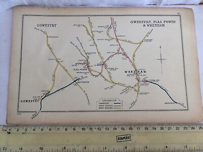
$13.84 Shipping Location: SOUTHAMPTON, United Kingdom NOW FREE POST UK This is an original old map issued by the Railway Clearing House in 1905 as dated in the bottom left hand corner. The areas cover Wrexham ... morePlas Power& Gwersyllt with many colliery lines ie New Broughton- Westminster- Gatewin + Oswestry to Whittington& preesgweene.It involves all of the different old prenationalised railway company lines and stations both goods& passenger with destinations plus milage figures. Lines of that time are depicted with different colours and includes sections of the Cambrian. Great Central& GWR.This is a very detailed official Railway map in very good condition. This is not a reprint but an original map of almost 110 years of age. This some what rare old reference map will be dispatched in firm card for protection. I have more maps and railway history in my ebay archive/ shop. ANY number of maps can be posted for the one quoted cost. I POST 5 days a week ALL PAYMENT options are listed in the payment details section- THANK YOU for viewing my item. Feel free to checkout my feedback and please email me if you require extra information I always obtain proof of posting. Recorded delivery or insurance are available as optional extra GOOD LUCK Powered by
Buy It Now
$11.93 Shipping Location: Main Beach, Australia This is the 1st edition. There was a 2nd revised edition published in 1783. The last image shows a scan of the title page. This is for provenence only ... moreand not included with the sale of the map. SIZE: Page is approx. 25.2 x 14.5 cm's.
Buy It Now
$4.99 Shipping Location: Fairview, United States Included is a facsimile copy of the title page for authenticity. An Authentic Antique Map: Not a Modern Reproduction! It is from the. The pics are of ... morethe actual map.
Buy It Now
$4.95 Shipping Location: Dover, United States Issued 1897, Leipzig by Wagner & Debes. Highly detailed late 19th century color lithographed city plan.
Buy It Now
$29.41 Shipping Location: NEWBIGGIN-BY-THE-SEA, United Kingdom Good big map England & Wales by Henry Teesdale dated 1834. Also a faint ink mark inside right margin. In the first scan I have showed the map as it will ... morelook in a mount. Impressive image size 330x415mm.
Buy It Now
$25.66 Shipping Location: WIGAN, United Kingdom Date and Edition: - Cloth map unsure of date - Sheet 7. Condition: - Cover and map are in lightly used condition and very good for age. Up to 2kg will ... morebe £3.95, up to 5Kg £7.85, up to 10Kg £9.50, upto 20Kg £11.00.
Buy It Now
$13.84 Shipping Location: MANCHESTER, United Kingdom He based his atlases on the plates used by Edward Weller for his Weekly Dispatch Atlas. edited and published by George. W. Bacon, London, 1883. This map ... moreby George Washington Bacon is from The New Large Scale Ordnance Map of The British Isles with Plans of Towns.
Buy It Now
$20.21 Shipping Location: United Kingdom Amongst his considerable portfolio were various atlases, many of which focussed on the educational publishing market. Weller also published The Crown ... moreAtlas in 1871. After Wellers death in 1884, many of these astonishingly detailed plates were sold on to other map makers, including George Washington Bacon.
Buy It Now
$20.39 Shipping Location: BECCLES, United Kingdom 1965 map of Southern Ghana, scale 1:500,000. Pages crisp and clear with tight binding.
Buy It Now
$20.69 Shipping Location: CREWE, United Kingdom Very old, yellowy map, from what appears to be 1940's. Like the other maps we have in this series appears to have been joined? Not sure if were made like ... morethis or not. See last photo. It's just on one side if that makes sense! Lots of maps from a collection to list in next few days Any questions please ask Thanks for Looking
Buy It Now
$7.00 Shipping Location: North Wales, United States 1901 ANTIQUE CRAM ATLAS MAP-NEW SOUTH WALES-AUSTRALIA-EXCELLENT DETAIL ORIGINAL ATLAS MAP PLEASE SEE PHOTOS AS PART OF THE DESCRIPTION CONDITION: MAP ... moreIS IN GOOD CONDITION. SIZE: APPROXIMATELY 14" X 22" SHIPPING: U.S. FIRST CLASS RATE - $8.00 - ANY ITEM WHICH SELLS FOR OVER $100 WILL REQUIRE INSURANCE WE COMBINE SHIPPING FOR MULTIPLE WINS. THANK YOU FOR YOUR INTEREST IN OUR AUCTIONS!.
Buy It Now
$8.80 Shipping Location: United Kingdom Antique Copper Engraved Map Published 1819, London for.
Buy It Now
$8.80 Shipping Location: United Kingdom Folds as issued. Antique Copper Engraved Map Published 1812, London for.
Buy It Now
$8.79 Shipping Location: GLASGOW, United Kingdom Provenance: Taken from Curiosities of Great Britain. England and Wales Delineated by Thomas Dugdale. London Published by L Tallis, 3 Jewin St c1840. We ... moredo not deal in facsimiles or reproductions of any kind.
Buy It Now
$4.99 Shipping Location: Fairview, United States It was publsihed in Paris, H. Langlois, 1841. Included is a facsimile copy of the title page for authenticity. Condition: The map is in Very Good to Excellent ... morecondition with overall light tonal aging and original hand coloring as issued.
Buy It Now
$5.95 Shipping Location: Mchenry, United States This is a city map of Nurnberg, Germany. The map is from a Baekeder guide to Southern Germany published in 1909. Centerfold is as issued. 8.25" x 6.25". ... moreGood condition.
Buy It Now
$11.95 Shipping Location: ILKLEY, United Kingdom The engraved images surrounding the map are intended to represent the area and its produce / resources. Date: 1828.
Buy It Now
$62.88 Shipping Location: WHITCHURCH, United Kingdom Large map Cardiff 1961 OS Ordnance Survey Outline edition 1 inch to 1 mile Large Map of Cardiff. Ordnance Survey of Great Britain. One Inch to One Mile ... moreMap(Seventh Series) Measures 35.5 c 28.5 inches. Outline Edition- Sheet 154. Dated 1961. Printed on thick paper. This map is nice and clean, some edges have minor wear commensurate with age, the back may have some grubby marks. This map has never been creased, it's been stored for years in a tube. This map will be posted rolled in a large protective cardboard tube.
Buy It Now
$5.95 Shipping Location: Dover, United States Issued 1672, Paris by Mallet. Emphasizes the military defenses of the city, showing the ramparts and outline of the city walls. Plan de la Ville d'Athe. ... moreCharming 17th century miniature engraved map, with lovely hand color.
$24.70 Shipping Location: ABERGELE, United Kingdom
Buy It Now
$10.06 Shipping Location: POOLE, United Kingdom MONTGOMERYSHIRE WALES BY JOHN OWEN & EMANUEL BOWEN c1720 WITH A DESCRIPTION OF THE ROAD FROM GLOUCESTER TO MONTGOMERY. ON THE REVERSE IS AN UNCOLOURED ... moreROAD MAP DESCRIBING THE ROAD FROM GLOUCESTER TO HEREFORD . THIS ORIGINAL ANTIQUE MAP WAS PRODUCED FOR "BRITANNIA DEPICTA" PUBLISHED BY THOMAS BOWLES c1720 THIS COPPER ENGRAVED MAP IS IN GOOD CONDITION WITH A CLEAR IMPRESSION AND HAND COLOURING. THIS IS A GENUINE ANTIQUE MAP AROUND 300 YEARS OLD THE MAP MEASURES APPROX 7.75 x 5.25 ins (19.5 x 13 cms) PLEASE NOTE THIS IS TWO MAPS PRINTED BACK TO BACK ON ONE SHEET.
Buy It Now
$13.84 Shipping Location: MANCHESTER, United Kingdom This map is from Letts's Popular County Atlas published by Letts, Son & Co., London, 1884. This is an original antique, over 135 years old.
Buy It Now
$20.21 Shipping Location: United Kingdom Gallia by Edward Weller. Atlas Map. Small double spread map of Gallia with coloured boundaries. Centrefold as issued. Amongst his considerable portfolio ... morewere various atlases, many of which focussed on the educational publishing market.

Buy It Now
Free Shipping Location: Monroeville, United States Welcome to my auction- I am a sole trader grown out of a self-financing hobby. I usually like the things I sell. And I am happy when they go to other ... morecollectors. I try to describe items honestly and carefully and I believe my packing is fairly priced and outstanding in its execution! ANTIQUE 1883 LETTS'S MAP(s) of NEW SOUTH WALES e AUSTRALIA LETTS'S ATLAS from LETTS'S ATLAS 149 EXCELLENT see below for descriptions of condition I have just moved house and looked critically at my extensive collection of maps and have decided to sell them- so over the next few weeks. Look out for more unusual rare and great condition Ordnance Survey and other maps- no reserves- low start prices This is a very rare sheet from a disbound 1883 Letts's Popular Atlas- the atlas was complete when I bought it but was disbound- the quality of the bookbinding and preparation means that the sheets which are folded vertically in half- are printed on one side only and have no stitching holes as they were originally clamped with other supporting leaves- I will be selling a number of these and will post them in their folded position properly supported and marked DO NOT BEND- each OPEN sheet is 17 x 14 inches I have included photos of the Atlas title sheet and covers but this sale is for ONE SHEET only- 149 New South Wales Eastern Portion with a larger scale inset of Sydney and a smaller scale inset of the seabord- Census to 1871- please refer to pics Series: Letts's Popular Atlas Material: paper Scale: 1 inch to 28 miles Sheet No: 149 New South Wales(Australia) Print info: Published as part of Letts's Popular Atlas 1883 Condition Map: this sheet has a couple of faint smudges in the margin and some light discolouration along the fold- o/w excellent bright and clean Please refer to any pics as they form part of the description- happy to answer questions will be posted VERY well supported- packs at c.150gm marked DO NOT BEND International buyers PLEASE check postage by email Please check my other items to see other interestin
Buy It Now
$10.06 Shipping Condition: Unspecified Location: LONDON, United Kingdom Antique engraved map with original outline colour, 1812. DATE PRINTED: 1812. TYPE: Antique engraved map with original outline colour.
Buy It Now
$6.95 Shipping Location: Dover, United States Issued 1850, Paris by Migeon. Vignettes depicts a city view of Valence, and a portrait of Championnet. Decorative mid 19th century engraved map with original ... moreoutline hand color.
Buy It Now
$4.99 Shipping Location: Fairview, United States Atlas Portatif de France (Paris, 1833). The map is not mounted nor matted, being sold as a single sheet as seen in the first pic. A nice miniature map ... morewith much detail. Condition: The map is in Fair condition for its age, blank on the reverse, basically as seen in the pic.
$24.58 Shipping Location: ST. ASAPH, United Kingdom Holywell Rural. Holywell Station. Greenfield Harbour. Greenfield Hall School.
Buy It Now
$5.61 Shipping Location: Albany, United States Duckhams Motor Map of England& Wales 1910 Original Duckhams Motor Map of England& Wales 1910. 1910 was the first year thsat Duckams Oils produced ... morea road map containing information on their products and other info including speed traps. Also comments from satisfied customers. The map is made up of a series of cards and is in very good condition for it's age(103 years! A must have for the veteran or Edwardian car owner. di,RcmdId ViewItemDescV4,RlogId p4%60bo7%60jtb9%3Fuk%601d72f%2Bishhov%3C%3Edi-141fbeaa897-0xfc-
Buy It Now
$20.15 Shipping Location: FARNBOROUGH, United Kingdom R E P R O D U C T I O N J O H N S P E E D M A P S F R O M O L D T O W N S B O O K S& M A P S WALES GLAMORGANSHIRE by John Speed A map of the county ... morecopied from his famous atlas titled"The Theatre of the Empire of Great Britaine" published in 1611. Includes town plans of Cardyfe and Landaffe. With notable streets& places named. Printed area is 50 x 37 cm. approx. plus generous border for mounting& framing. This is a reproduction map. Printed on an off white background on 180gsm matt coated paper POSTED ROLLED IN A CARDBOARD TUBE NEXT WORKING DAY RETURNS ACCEPTED- PLEASE CONTACT ME FIRST Powered by Powered by
Buy It Now
$10.06 Shipping Location: POOLE, United Kingdom SOUTH WALES BY JOHN CARY c1793 LONDON. PUBLISHED JAN 1st 1793 BY J. CARY. ENGRAVER & MAP SELLER, STRAND. VERY DETAILED COPPER ENGRAVED MAP WITH HAND COLOUR ... moreTHIS 1793 ENGRAVED MAP IS IN GOOD CONDITION WITH A GOOD CLEAR IMPRESSION & HAND COLOUR. THIS IS A GENUINE ANTIQUE MAP OVER 220 YEARS OLD THE MAP MEASURES APPROX 10.5 x 8.25 ins (26 x 21cms) PLUS GOOD MARGINS. JOHN CARY (1754-1835) WAS A PROLIFIC LONDON BASED MAPMAKER WHOSE MASTERY OF BOTH ENGRAVING AND CARTOGRAPHY RESULTED IN A SERIES OF WORKS THAT REDEFINED MAP MAKING IN THE EARLY 19th CENTURY.
Buy It Now
$6.95 Shipping Location: Dover, United States Issued 1711, London by Cluverius. Bottom blank margin is very narrow, lower left blank margin nicely extended with near matching old paper in order to ... morefacilitate matting and display of the map. Early 18th century engraved map with lovely hand color.
Buy It Now
$6.95 Shipping Location: Dover, United States Ireland to Illustrated the Pauperism of the People. Thematically focused on the system within the country. A detailed key notes unions and the number ... moreof individuals who received welfare. Issued 1882, Edinburgh by Johnston.
|
|
|
|
NORTH WALES by John CARY. Miniature antique map. Original colour, 1812
North Wales Antique engraved map with original outline colour. 1812 Title of map: North Wales' The image below shows an enlarged cross section from the centre of the map to show the level of printed detail: DATE PRINTED: 1812 IMAGE SIZE: Approx 14.5 x 10.0cm. 5.75 x 3.75 inches(Small) ARTIST/CARTOGRAPHER/ENGRAVER: John Cary PROVENANCE: Cary's Traveller's Companion" Published by John Cary, London: 5th Edition TYPE: Antique engraved map with original outline colour VERSO: There is nothing printed on the reverse side. Which is plain CONDITION: Good; suitable for framing. Please check the scan for any blemishes prior to making your purchase. Virtually all antiquarian maps and prints are subject to some normal aging due to use and time which is not obtrusive unless otherwise stated. I offer a no questions asked return policy- ... moresee below. AUTHENTICITY: This is an authentic historic print. Published at the date stated above. I do not offer reproductions. It is not a modern copy. The term'original' when applied to a print means that it was printed at the first or original date of publication; it does not imply that the item is unique. Print' means any image created by applying an inked block to paper or card under pressure by any method including wood engraving, steel engraving, copperplate, wood cut and lithography. REMARKS: FRANCE: Gravures et Cartes anciennes. DEUTSCHLAND: Alte Lankarten und Stadt ansichten. ITALIA: Stampe e Mappe antiche. ESPAÑA: Mapas antiquos y impresiones antiguas. E and OE. Force Majeure. English law shall apply. RETURNS POLICY: I offer a no questions returns policy. All I ask is that you pay return shipping and mail back to me in original condition. Suitably packed& insured, within 14 days of receipt.
|
|
|
SOUTH WALES by John CARY. Miniature antique map. Original colour, 1812
South Wales Antique engraved map with original outline colour. 1812 Title of map: South Wales' The image below shows an enlarged cross section from the centre of the map to show the level of printed detail: DATE PRINTED: 1812 IMAGE SIZE: Approx 14.5 x 10.0cm. 5.75 x 3.75 inches(Small) ARTIST/CARTOGRAPHER/ENGRAVER: John Cary PROVENANCE: Cary's Traveller's Companion" Published by John Cary, London: 5th Edition TYPE: Antique engraved map with original outline colour VERSO: There is nothing printed on the reverse side. Which is plain CONDITION: Good; suitable for framing. Please check the scan for any blemishes prior to making your purchase. Virtually all antiquarian maps and prints are subject to some normal aging due to use and time which is not obtrusive unless otherwise stated. I offer a no questions asked return policy- ... moresee below. AUTHENTICITY: This is an authentic historic print. Published at the date stated above. I do not offer reproductions. It is not a modern copy. The term'original' when applied to a print means that it was printed at the first or original date of publication; it does not imply that the item is unique. Print' means any image created by applying an inked block to paper or card under pressure by any method including wood engraving, steel engraving, copperplate, wood cut and lithography. REMARKS: FRANCE: Gravures et Cartes anciennes. DEUTSCHLAND: Alte Lankarten und Stadt ansichten. ITALIA: Stampe e Mappe antiche. ESPAÑA: Mapas antiquos y impresiones antiguas. E and OE. Force Majeure. English law shall apply. RETURNS POLICY: I offer a no questions returns policy. All I ask is that you pay return shipping and mail back to me in original condition. Suitably packed& insured, within 14 days of receipt.
|
|
|
WALES, POWYS, CEFNLLYS, Boundaries Commission Antique Map 1868
WALES. POWYS, CEFNLLYS, Boundaries Commission Antique Map 1868, WALES. POWYS, CEFNLLYS, Boundaries Commission Antique Map 1868 NEW RADNOR CEFNLLYS by Captain R.M. Parsons& Colonel Sir Henry James Published London 1868 An antique map drawn up by Captain R.M. Parsons and Colonel Sir Henry James of the Royal Engineers. And published for the Boundaries Commission of 1867/8, using the 19th century zincograph printing process. The map bears the facsimile signature of Henry James. The country was surveyed by the commission in 1867 to 1868 to update the boundaries set down in the earlier 1832 reform bill- a major shake up of the nation's parliamentary representation. A scale of two inches to a mile is used and the original outline hand colouring identifies the 1832 and 1868 boundaries. The detail shows individual buildings. Farms, villages ... moreand hamlets. Credited& dated within the plate. Fine condition save for light creasing mostly to the top border. Please view a further close up image. Measuring approx. 14" x 10" 360mm x 250mm) overall. On light grade paper, blank verso. A GENUINE ANTIQUE MAP GUARANTEED OVER 140 YEARS OLD FROM LINDISFARNE PRINTS FREE SHIPPING UK. INTERNATIONAL SHIPPING 2 ITEMS WILL BE COMBINED WITH ONE SHIPPING CHARGE. 3 ITEMS OR MORE SHIPPING FREE OF CHARGE WORLDWIDE. FXC914 Closeups, Shipping Process, Two items are always combined for shipping and three items or more are shipped free of charge. Worldwide"Please see item description for postage costs" Payment Options, All major Credit and Debit Cards accepted by phone PAYPAL. Personal cheque drawn on UK banks only. Postal Orders from UK post offices only. Bank transfer- please email for details. About Us, Lindisfarne Prints is a small family business specialising in genuine antique maps and prints at affordable prices.Established in 1995 and trading online s
|
|
|
map 1868 Carmarthen Abergwili Wales antique (MAPS WANTED)
map 1868 Carmarthen Abergwili Wales This listing is for the old ordnance survey map as described in the title and shown in the photos above please study photos carefully if there are and marks wear or damage they will be shown in the photos above map sixe is 14.5 x 10 inches 40g.RcmdId ViewItemDescV4,RlogId p4%60bo7%60jtb9%3Fuk%601d72f%2B%3E40g-1485e70ccfb-0x10d-
|
|
|
PEMBROKESHIRE. Antique county map. Wales, 1893
Pembroke Antique colour map. 1893 Title of map: Pembroke' The image below shows an enlarged cross section from the centre of the map to show the level of printed detail. This map is folding hence the centrefold line may show on the image below: DATE PRINTED: 1893 IMAGE SIZE: Approx 22.0 x 28.5cm. 8.5 x 11.25 inches(Large) Please note that this is a folding map. ARTIST/CARTOGRAPHER/ENGRAVER: F.S. Weller PROVENANCE: The Comprehensive Gazetteer of England and Wales" Edited by J.H.F. Brabner. Published by William Mackenzie, London TYPE: Antique colour map VERSO: There is nothing printed on the reverse side. Which is plain CONDITION: Good; suitable for framing. However. Please note: The image shown may have been taken from a different example of this map than that which is offered for sale. The map you will receive is in good condition ... morebut there may be minor variations in the condition from that shown in the image. Please check the scan for any blemishes prior to making your purchase. Virtually all antiquarian maps and prints are subject to some normal aging due to use and time which is not obtrusive unless otherwise stated. I offer a no questions asked return policy- see below. AUTHENTICITY: This is an authentic historic print. Published at the date stated above. I do not offer reproductions. It is not a modern copy. The term'original' when applied to a print means that it was printed at the first or original date of publication; it does not imply that the item is unique. Print' means any image created by applying an inked block to paper or card under pressure by any method including wood engraving, steel engraving, copperplate, wood cut and lithography. REMARKS: FRANCE: Gravures et Cartes anciennes. DEUTSCHLAND: Alte Lankarten und Stadt ansichten. ITALIA: Stampe e Mappe antiche. ESPAÑA: Mapas antiquos y impresiones antiguas. E and OE. Force Majeure. English law shall apply. RETURNS POLICY: I offer a no questions returns policy. All I ask is that you pay return shipping and mail back to me i
|
|
|
CARNARVONSHIRE; INSET MAP OF ANGLESEY. Antique county map. Wales, 1893
Carnarvon; Inset map of Anglesey Antique colour map. 1893 Title of map: Carnarvon; Inset map of Anglesey' The image below shows an enlarged cross section from the centre of the map to show the level of printed detail. This map is folding hence the centrefold line may show on the image below: DATE PRINTED: 1893 IMAGE SIZE: Approx 22.5 x 29.0cm. 8.75 x 11.25 inches(Large) Please note that this is a folding map. ARTIST/CARTOGRAPHER/ENGRAVER: F.S. Weller PROVENANCE: The Comprehensive Gazetteer of England and Wales" Edited by J.H.F. Brabner. Published by William Mackenzie, London TYPE: Antique colour map VERSO: There is nothing printed on the reverse side. Which is plain CONDITION: Good; suitable for framing. However. Please note: The image shown may have been taken from a different example of this map than that which is offered for sale. ... moreThe map you will receive is in good condition but there may be minor variations in the condition from that shown in the image. Please check the scan for any blemishes prior to making your purchase. Virtually all antiquarian maps and prints are subject to some normal aging due to use and time which is not obtrusive unless otherwise stated. I offer a no questions asked return policy- see below. AUTHENTICITY: This is an authentic historic print. Published at the date stated above. I do not offer reproductions. It is not a modern copy. The term'original' when applied to a print means that it was printed at the first or original date of publication; it does not imply that the item is unique. Print' means any image created by applying an inked block to paper or card under pressure by any method including wood engraving, steel engraving, copperplate, wood cut and lithography. REMARKS: FRANCE: Gravures et Cartes anciennes. DEUTSCHLAND: Alte Lankarten und Stadt ansichten. ITALIA: Stampe e Mappe antiche. ESPAÑA: Mapas antiquos y impresiones antiguas. E and OE. Force Majeure. English law shall apply. RETURNS POLICY: I offer a no questions returns policy. All I ask is t
|
|
|
BRECKNOCKSHIRE. Antique county map. Wales, 1893
Brecknock Antique colour map. 1893 Title of map: Brecknock' The image below shows an enlarged cross section from the centre of the map to show the level of printed detail. This map is folding hence the centrefold line may show on the image below: DATE PRINTED: 1893 IMAGE SIZE: Approx 29.0 x 22.0cm. 11.5 x 8.75 inches(Large) Please note that this is a folding map. ARTIST/CARTOGRAPHER/ENGRAVER: F.S. Weller PROVENANCE: The Comprehensive Gazetteer of England and Wales" Edited by J.H.F. Brabner. Published by William Mackenzie, London TYPE: Antique colour map VERSO: There is nothing printed on the reverse side. Which is plain CONDITION: Good; suitable for framing. However. Please note: The image shown may have been taken from a different example of this map than that which is offered for sale. The map you will receive is in good condition ... morebut there may be minor variations in the condition from that shown in the image. Please check the scan for any blemishes prior to making your purchase. Virtually all antiquarian maps and prints are subject to some normal aging due to use and time which is not obtrusive unless otherwise stated. I offer a no questions asked return policy- see below. AUTHENTICITY: This is an authentic historic print. Published at the date stated above. I do not offer reproductions. It is not a modern copy. The term'original' when applied to a print means that it was printed at the first or original date of publication; it does not imply that the item is unique. Print' means any image created by applying an inked block to paper or card under pressure by any method including wood engraving, steel engraving, copperplate, wood cut and lithography. REMARKS: FRANCE: Gravures et Cartes anciennes. DEUTSCHLAND: Alte Lankarten und Stadt ansichten. ITALIA: Stampe e Mappe antiche. ESPAÑA: Mapas antiquos y impresiones antiguas. E and OE. Force Majeure. English law shall apply. RETURNS POLICY: I offer a no questions returns policy. All I ask is that you pay return shipping and mail back to me
|
|
|
MONTGOMERYSHIRE. Antique county map. Wales, 1893
Montgomery Antique colour map. 1893 Title of map: Montgomery' The image below shows an enlarged cross section from the centre of the map to show the level of printed detail. This map is folding hence the centrefold line may show on the image below: DATE PRINTED: 1893 IMAGE SIZE: Approx 22.5 x 28.5cm. 8.75 x 11.25 inches(Large) Please note that this is a folding map. ARTIST/CARTOGRAPHER/ENGRAVER: Unsigned PROVENANCE: The Comprehensive Gazetteer of England and Wales" Edited by J.H.F. Brabner. Published by William Mackenzie, London TYPE: Antique colour map VERSO: There is nothing printed on the reverse side. Which is plain CONDITION: Good; suitable for framing. However. Please note: The image shown may have been taken from a different example of this map than that which is offered for sale. The map you will receive is in good condition ... morebut there may be minor variations in the condition from that shown in the image. Please check the scan for any blemishes prior to making your purchase. Virtually all antiquarian maps and prints are subject to some normal aging due to use and time which is not obtrusive unless otherwise stated. I offer a no questions asked return policy- see below. AUTHENTICITY: This is an authentic historic print. Published at the date stated above. I do not offer reproductions. It is not a modern copy. The term'original' when applied to a print means that it was printed at the first or original date of publication; it does not imply that the item is unique. Print' means any image created by applying an inked block to paper or card under pressure by any method including wood engraving, steel engraving, copperplate, wood cut and lithography. REMARKS: FRANCE: Gravures et Cartes anciennes. DEUTSCHLAND: Alte Lankarten und Stadt ansichten. ITALIA: Stampe e Mappe antiche. ESPAÑA: Mapas antiquos y impresiones antiguas. E and OE. Force Majeure. English law shall apply. RETURNS POLICY: I offer a no questions returns policy. All I ask is that you pay return shipping and mail back to me
|
|
|
PHILIPS NEW SERIES OF COUNTY MAPS - NORTH WALES 1880's
This wonderful map is in a hard cover with an oil cloth map inside. The map is for North Wales. This was published by Philips New Series of County Maps. From the Ordnance Survey. The map has a stationers label in Liverpool, William Potter on Exchange Street as the Appointed Agent for the Sale of Ordnance Maps. There are a couple of folds in the paper attached to the oil cloth. The map is 18 inches wide by 14 1/2 inches tall. The map is circa 1880. Powered by SixBit's eCommerce Solution
|
|
|
RADNORSHIRE. Antique county map. Wales, 1893
Radnor Antique colour map. 1893 Title of map: Radnor' The image below shows an enlarged cross section from the centre of the map to show the level of printed detail. This map is folding hence the centrefold line may show on the image below: DATE PRINTED: 1893 IMAGE SIZE: Approx 28.0 x 22.0cm. 11 x 8.75 inches(Large) Please note that this is a folding map. ARTIST/CARTOGRAPHER/ENGRAVER: F.S. Weller PROVENANCE: The Comprehensive Gazetteer of England and Wales" Edited by J.H.F. Brabner. Published by William Mackenzie, London TYPE: Antique colour map VERSO: There is nothing printed on the reverse side. Which is plain CONDITION: Good; suitable for framing. However. Please note: The image shown may have been taken from a different example of this map than that which is offered for sale. The map you will receive is in good condition but ... morethere may be minor variations in the condition from that shown in the image. Please check the scan for any blemishes prior to making your purchase. Virtually all antiquarian maps and prints are subject to some normal aging due to use and time which is not obtrusive unless otherwise stated. I offer a no questions asked return policy- see below. AUTHENTICITY: This is an authentic historic print. Published at the date stated above. I do not offer reproductions. It is not a modern copy. The term'original' when applied to a print means that it was printed at the first or original date of publication; it does not imply that the item is unique. Print' means any image created by applying an inked block to paper or card under pressure by any method including wood engraving, steel engraving, copperplate, wood cut and lithography. REMARKS: FRANCE: Gravures et Cartes anciennes. DEUTSCHLAND: Alte Lankarten und Stadt ansichten. ITALIA: Stampe e Mappe antiche. ESPAÑA: Mapas antiquos y impresiones antiguas. E and OE. Force Majeure. English law shall apply. RETURNS POLICY: I offer a no questions returns policy. All I ask is that you pay return shipping and mail back to me in orig
|
|
|
Antique map of NORTH WALES by JOHN CARY. Original outline colour, 1787
North Wales Antique engraved copperplate map with original outline colour. 1787 Title of map: North Wales' The image below shows an enlarged cross section from the centre of the map to show the level of printed detail: DATE PRINTED: 1787 IMAGE SIZE: Approx 22.0 x 27.0cm. 8.5 x 10.5 inches(Medium) ARTIST/CARTOGRAPHER/ENGRAVER: John Cary PROVENANCE: Cary's New& Correct English Atlas" Published by John Cary. London TYPE: Antique engraved copperplate map with original outline colour VERSO: There is nothing printed on the reverse side. Which is plain CONDITION: Good; suitable for framing. However. Please note: The image shown may have been taken from a different example of this map than that which is offered for sale. The map you will receive is in good condition but there may be minor variations in the condition from that shown ... morein the image. Please check the scan for any blemishes prior to making your purchase. Virtually all antiquarian maps and prints are subject to some normal aging due to use and time which is not obtrusive unless otherwise stated. I offer a no questions asked return policy- see below. AUTHENTICITY: This is an authentic historic print. Published at the date stated above. I do not offer reproductions. It is not a modern copy. The term'original' when applied to a print means that it was printed at the first or original date of publication; it does not imply that the item is unique. Print' means any image created by applying an inked block to paper or card under pressure by any method including wood engraving, steel engraving, copperplate, wood cut and lithography. REMARKS: FRANCE: Gravures et Cartes anciennes. DEUTSCHLAND: Alte Lankarten und Stadt ansichten. ITALIA: Stampe e Mappe antiche. ESPAÑA: Mapas antiquos y impresiones antiguas. E and OE. Force Majeure. English law shall apply. RETURNS POLICY: I offer a no questions returns policy. All I ask is that you pay return shipping and mail back to me in original condition. Suitably packed& insured, within 14 days
|
|
|
DENBIGHSHIRE AND FLINT. Antique county map. Wales, 1893
Denbigh and Flint Antique colour map. 1893 Title of map: Denbigh and Flint' The image below shows an enlarged cross section from the centre of the map to show the level of printed detail. This map is folding hence the centrefold line may show on the image below: DATE PRINTED: 1893 IMAGE SIZE: Approx 22.0 x 28.5cm. 8.75 x 11.25 inches(Large) Please note that this is a folding map. ARTIST/CARTOGRAPHER/ENGRAVER: F.S. Weller PROVENANCE: The Comprehensive Gazetteer of England and Wales" Edited by J.H.F. Brabner. Published by William Mackenzie, London TYPE: Antique colour map VERSO: There is nothing printed on the reverse side. Which is plain CONDITION: Good; suitable for framing. However. Please note: The image shown may have been taken from a different example of this map than that which is offered for sale. The map you will receive ... moreis in good condition but there may be minor variations in the condition from that shown in the image. Please check the scan for any blemishes prior to making your purchase. Virtually all antiquarian maps and prints are subject to some normal aging due to use and time which is not obtrusive unless otherwise stated. I offer a no questions asked return policy- see below. AUTHENTICITY: This is an authentic historic print. Published at the date stated above. I do not offer reproductions. It is not a modern copy. The term'original' when applied to a print means that it was printed at the first or original date of publication; it does not imply that the item is unique. Print' means any image created by applying an inked block to paper or card under pressure by any method including wood engraving, steel engraving, copperplate, wood cut and lithography. REMARKS: FRANCE: Gravures et Cartes anciennes. DEUTSCHLAND: Alte Lankarten und Stadt ansichten. ITALIA: Stampe e Mappe antiche. ESPAÑA: Mapas antiquos y impresiones antiguas. E and OE. Force Majeure. English law shall apply. RETURNS POLICY: I offer a no questions returns policy. All I ask is that you pay return shipping an
|
|
|
MERIONETHSHIRE. Antique county map. Wales, 1893
Merioneth Antique colour map. 1893 Title of map: Merioneth' The image below shows an enlarged cross section from the centre of the map to show the level of printed detail. This map is folding hence the centrefold line may show on the image below: DATE PRINTED: 1893 IMAGE SIZE: Approx 22.0 x 28.5cm. 8.75 x 11.25 inches(Large) Please note that this is a folding map. ARTIST/CARTOGRAPHER/ENGRAVER: Unsigned PROVENANCE: The Comprehensive Gazetteer of England and Wales" Edited by J.H.F. Brabner. Published by William Mackenzie, London TYPE: Antique colour map VERSO: There is nothing printed on the reverse side. Which is plain CONDITION: Good; suitable for framing. However. Please note: The image shown may have been taken from a different example of this map than that which is offered for sale. The map you will receive is in good condition ... morebut there may be minor variations in the condition from that shown in the image. Please check the scan for any blemishes prior to making your purchase. Virtually all antiquarian maps and prints are subject to some normal aging due to use and time which is not obtrusive unless otherwise stated. I offer a no questions asked return policy- see below. AUTHENTICITY: This is an authentic historic print. Published at the date stated above. I do not offer reproductions. It is not a modern copy. The term'original' when applied to a print means that it was printed at the first or original date of publication; it does not imply that the item is unique. Print' means any image created by applying an inked block to paper or card under pressure by any method including wood engraving, steel engraving, copperplate, wood cut and lithography. REMARKS: FRANCE: Gravures et Cartes anciennes. DEUTSCHLAND: Alte Lankarten und Stadt ansichten. ITALIA: Stampe e Mappe antiche. ESPAÑA: Mapas antiquos y impresiones antiguas. E and OE. Force Majeure. English law shall apply. RETURNS POLICY: I offer a no questions returns policy. All I ask is that you pay return shipping and mail back to me i
|
|
|
CARDIGANSHIRE. Antique county map. Wales, 1893
Cardigan Antique colour map. 1893 Title of map: Cardigan' The image below shows an enlarged cross section from the centre of the map to show the level of printed detail. This map is folding hence the centrefold line may show on the image below: DATE PRINTED: 1893 IMAGE SIZE: Approx 22.0 x 28.5cm. 8.5 x 11.25 inches(Large) Please note that this is a folding map. ARTIST/CARTOGRAPHER/ENGRAVER: F.S. Weller PROVENANCE: The Comprehensive Gazetteer of England and Wales" Edited by J.H.F. Brabner. Published by William Mackenzie, London TYPE: Antique colour map VERSO: There is nothing printed on the reverse side. Which is plain CONDITION: Good; suitable for framing. However. Please note: The image shown may have been taken from a different example of this map than that which is offered for sale. The map you will receive is in good condition ... morebut there may be minor variations in the condition from that shown in the image. Please check the scan for any blemishes prior to making your purchase. Virtually all antiquarian maps and prints are subject to some normal aging due to use and time which is not obtrusive unless otherwise stated. I offer a no questions asked return policy- see below. AUTHENTICITY: This is an authentic historic print. Published at the date stated above. I do not offer reproductions. It is not a modern copy. The term'original' when applied to a print means that it was printed at the first or original date of publication; it does not imply that the item is unique. Print' means any image created by applying an inked block to paper or card under pressure by any method including wood engraving, steel engraving, copperplate, wood cut and lithography. REMARKS: FRANCE: Gravures et Cartes anciennes. DEUTSCHLAND: Alte Lankarten und Stadt ansichten. ITALIA: Stampe e Mappe antiche. ESPAÑA: Mapas antiquos y impresiones antiguas. E and OE. Force Majeure. English law shall apply. RETURNS POLICY: I offer a no questions returns policy. All I ask is that you pay return shipping and mail back to me i
|
|
|
Antique map of SOUTH WALES by JOHN CARY. Original outline colour, 1787
South Wales Antique engraved copperplate map with original outline colour. 1787 Title of map: South Wales' The image below shows an enlarged cross section from the centre of the map to show the level of printed detail: DATE PRINTED: 1787 IMAGE SIZE: Approx 22.0 x 27.0cm. 8.75 x 10.5 inches(Medium) ARTIST/CARTOGRAPHER/ENGRAVER: John Cary PROVENANCE: Cary's New& Correct English Atlas" Published by John Cary. London TYPE: Antique engraved copperplate map with original outline colour VERSO: There is nothing printed on the reverse side. Which is plain CONDITION: Good; suitable for framing. However. Please note: The image shown may have been taken from a different example of this map than that which is offered for sale. The map you will receive is in good condition but there may be minor variations in the condition from that shown ... morein the image. Please check the scan for any blemishes prior to making your purchase. Virtually all antiquarian maps and prints are subject to some normal aging due to use and time which is not obtrusive unless otherwise stated. I offer a no questions asked return policy- see below. AUTHENTICITY: This is an authentic historic print. Published at the date stated above. I do not offer reproductions. It is not a modern copy. The term'original' when applied to a print means that it was printed at the first or original date of publication; it does not imply that the item is unique. Print' means any image created by applying an inked block to paper or card under pressure by any method including wood engraving, steel engraving, copperplate, wood cut and lithography. REMARKS: FRANCE: Gravures et Cartes anciennes. DEUTSCHLAND: Alte Lankarten und Stadt ansichten. ITALIA: Stampe e Mappe antiche. ESPAÑA: Mapas antiquos y impresiones antiguas. E and OE. Force Majeure. English law shall apply. RETURNS POLICY: I offer a no questions returns policy. All I ask is that you pay return shipping and mail back to me in original condition. Suitably packed& insured, within 14 day
|
|
|
GLAMORGANSHIRE. Antique county map. Wales, 1893
Glamorgan Antique colour map. 1893 Title of map: Glamorgan' The image below shows an enlarged cross section from the centre of the map to show the level of printed detail. This map is folding hence the centrefold line may show on the image below: DATE PRINTED: 1893 IMAGE SIZE: Approx 22.0 x 28.5cm. 8.75 x 11.25 inches(Large) Please note that this is a folding map. ARTIST/CARTOGRAPHER/ENGRAVER: F.S. Weller PROVENANCE: The Comprehensive Gazetteer of England and Wales" Edited by J.H.F. Brabner. Published by William Mackenzie, London TYPE: Antique colour map VERSO: There is nothing printed on the reverse side. Which is plain CONDITION: Good; suitable for framing. However. Please note: The image shown may have been taken from a different example of this map than that which is offered for sale. The map you will receive is in good condition ... morebut there may be minor variations in the condition from that shown in the image. Please check the scan for any blemishes prior to making your purchase. Virtually all antiquarian maps and prints are subject to some normal aging due to use and time which is not obtrusive unless otherwise stated. I offer a no questions asked return policy- see below. AUTHENTICITY: This is an authentic historic print. Published at the date stated above. I do not offer reproductions. It is not a modern copy. The term'original' when applied to a print means that it was printed at the first or original date of publication; it does not imply that the item is unique. Print' means any image created by applying an inked block to paper or card under pressure by any method including wood engraving, steel engraving, copperplate, wood cut and lithography. REMARKS: FRANCE: Gravures et Cartes anciennes. DEUTSCHLAND: Alte Lankarten und Stadt ansichten. ITALIA: Stampe e Mappe antiche. ESPAÑA: Mapas antiquos y impresiones antiguas. E and OE. Force Majeure. English law shall apply. RETURNS POLICY: I offer a no questions returns policy. All I ask is that you pay return shipping and mail back to m
|
|
|
CARMARTHENSHIRE. Antique county map. Wales, 1893
Carmarthenshire Antique colour map. 1893 Title of map: Carmarthenshire' The image below shows an enlarged cross section from the centre of the map to show the level of printed detail. This map is folding hence the centrefold line may show on the image below: DATE PRINTED: 1893 IMAGE SIZE: Approx 22.5 x 28.5cm. 8.75 x 11 inches(Large) Please note that this is a folding map. ARTIST/CARTOGRAPHER/ENGRAVER: F.S. Weller PROVENANCE: The Comprehensive Gazetteer of England and Wales" Edited by J.H.F. Brabner. Published by William Mackenzie, London TYPE: Antique colour map VERSO: There is nothing printed on the reverse side. Which is plain CONDITION: Good; suitable for framing. However. Please note: The image shown may have been taken from a different example of this map than that which is offered for sale. The map you will receive is in good ... morecondition but there may be minor variations in the condition from that shown in the image. Please check the scan for any blemishes prior to making your purchase. Virtually all antiquarian maps and prints are subject to some normal aging due to use and time which is not obtrusive unless otherwise stated. I offer a no questions asked return policy- see below. AUTHENTICITY: This is an authentic historic print. Published at the date stated above. I do not offer reproductions. It is not a modern copy. The term'original' when applied to a print means that it was printed at the first or original date of publication; it does not imply that the item is unique. Print' means any image created by applying an inked block to paper or card under pressure by any method including wood engraving, steel engraving, copperplate, wood cut and lithography. REMARKS: FRANCE: Gravures et Cartes anciennes. DEUTSCHLAND: Alte Lankarten und Stadt ansichten. ITALIA: Stampe e Mappe antiche. ESPAÑA: Mapas antiquos y impresiones antiguas. E and OE. Force Majeure. English law shall apply. RETURNS POLICY: I offer a no questions returns policy. All I ask is that you pay return shipping and mail
|
|
|
Ist Edition 1611 Colored Map MONTGOMERY SHIRE Historie of Great Britaine SPEED
Ist Edition 1611 Colored Map MONTGOMERY SHIRE from Historie of Great Britaine John Speed detailed map with inset town map from disbound book. Foxing and slight bumps and tears. Coat of arms Philip Herbert of Montgomery. Details of the county and alphabetical list of towns in the county on reverse. Normal 0 Approximately 22 ins x 16ins SHIPPING TRACKING& INSURANCE IS INCLUDED IN THE SHIPPING PRICE QUOTED Normal 0 Low start and No Reserve. PLEASE READ MY TERMS BEFORE BIDDING Only Pay Pal and personal checks drawn in $'s on a US Bank. Or in UK £'s drawn on a UK Bank made payable to ELLEN HARRIMAN You can still pay me without having a PayPal account. You can pay using your credit card without creating a PayPal account. Just enter via the eBay'Pay Now' button and you'll be directed to a page where you can enter your ... morecredit card information. If you don't have a PayPal account. You'll be automatically redirected to a secure page in eBay checkout where you can enter your credit card information. As most of my items are posted/shipped from France. Do please ask for postal charges. Postal charges are purely estimates. I do not charge for wrapping and delivery to the post office. If there is an overpayment then l will make a refund through PayPal If you are not satisfied with my service please contact me through Ebay Messenger. Please wait for your invoice before making payment. Thanks for reading my terms
|
|
|
1611 Map The Countie of RADNOR from Historie of Great Britaine John Speed
First Edition- 1611- Map The Countie of RADNOR from Historie of Great Britaine John Speed detailed map with inset town map from disbound book. Foxing and slight bumps and tears on the left hand edge. Some water damage bottom right corner. Details of the county and alphabetical list of towns in the county on reverse. SHIPPING TRACKING& INSURANCE IS INCLUDED IN THE SHIPPING PRICE QUOTED Normal 0 Low start and No Reserve. PLEASE READ MY TERMS BEFORE BIDDING Only Pay Pal and personal checks drawn in $'s on a US Bank. Or in UK £'s drawn on a UK Bank made payable to ELLEN HARRIMAN You can still pay me without having a PayPal account. You can pay using your credit card without creating a PayPal account. Just enter via the eBay'Pay Now' button and you'll be directed to a page where you can enter your credit card information. ... moreIf you don't have a PayPal account. You'll be automatically redirected to a secure page in eBay checkout where you can enter your credit card information. As most of my items are posted/shipped from France. Do please ask for postal charges. Postal charges are purely estimates. I do not charge for wrapping and delivery to the post office. If there is an overpayment then l will make a refund through PayPal If you are not satisfied with my service please contact me through Ebay Messenger. Please wait for your invoice before making payment. Thanks for reading my terms 1.RcmdId ViewItemDescV4,RlogId p4%60bo7%60jtb9%3Fuk.rp73%28b0g%60%60%3E1-148881c6e60-0x110-
|
|
|
Original 1650 map of CARDIGANSHIRE by Jansson
Original 1650 map of CARDIGANSHIRE by Jansson. Coloured. Good condition(the dark patchea on left of print are a result of the scan) Ceretica sive CARDIGANSHIRE Comitates. Anglis CARDIGANSHIRE" Includes Prince of Wales feathers. Royal Coat of Arms, Compass Rose, 3 ships, a distance charT and a decorative cartouche showing a beaver, and a man, presumably a hunter, Reverse side has text in Latin Size of sheet 59 x 50 cm. Map image 510 x 382 cm Good The map is currently in a wooden frame. I will remove thiis for posting, unless you want it retained( for an extra postage charge)
|
|
|
# JUST RELEASED # HIGHLY DETAILED ORDNANCE SURVEY MAP,ABERTILLERY (SOUTH) 1899
ABERTILLERY(SOUTH) 1899 SHEET NUMBER 17.12(JUST RELEASED. IT'S NOT EVEN IN THE SHOPS YET) BRAND NEW. UNUSED IN SUPERB CONDITION This map is taken from the 1/2500 plans and reproduced by Alan Godfrey at about 15 inches to the mile. It is highly detailed, even showing individual houses, schools, works, churches and covers an area of about one and a half square miles This highly detailed detailed map covers the southern part of Abertillery. Features include Six Bells. Vivian Pit, Arail Griffin Colliery, Pen-rhiw-garreg, Pant-y-pwdin, GWR Western Valleys line, Arail, Iron& Tin Plate Works, mine workings, railway sidings etc. We include extracts from a directory on the reverse The map links up with sheet 17.08 Abertillery North to the north which I am also selling seperatly on eBay right now WHEN OPENED UP THEY MEASURE 60cm x 42cm AND ... moreWOULD LOOK GREAT IN A FRAME NO MORE P+P FOR ANY OTHER ITEMS BOUGHT, PLEASE DO ALL OF YOUR BUYING FIRST AND WHEN YOU HAVE FINISHED THEN GO THROUGH THE CHECKOUT WHERE YOU WILL SEE THE P+P SET AS ONE. DON'T BUY ONE THEN PAY FOR IT, THEN BUY ANOTHER AND PAY FOR IT, AND SO ON OTHERWISE EBAY SEE IT AS DIFFERENT TRANSACTIONS AND THE POSTAL DISCOUNTS WON'T KICK IN, YOU NEED TO DO ALL OF YOUR SHOPPING FIRST BEFORE GOING THROUGH CHECKOUT EMAIL ME IF YOU HAVE ANY QUESTIONS ON karenswift@blueyonder.co.uk SEE MY SHOP FOR MORE MAPS FROM THIS AND OTHER AREAS. CLICK HERE U.K. BUYERS CAN PAY EASILY BY BANK TRANSFER. IT'S FREE FOR YOU AND ME! Pay me with PayPal.
|
|
|
# JUST RELEASED # HIGHLY DETAILED ORDNANCE SURVEY MAP,ABERTILLERY (NORTH) 1899
ABERTILLERY(NORTH) 1899 SHEET NUMBER 17.08(JUST RELEASED. IT'S NOT EVEN IN THE SHOPS YET) BRAND NEW. UNUSED IN SUPERB CONDITION This map is taken from the 1/2500 plans and reproduced by Alan Godfrey at about 15 inches to the mile. It is highly detailed, even showing individual houses, schools, works, churches and covers an area of about one and a half square miles This highly detailed map covers the northern part of Abertillery. Features include Rose Heyworth Colliery. Newtown, GWR Western Valleys line, Coed Castellau, Pen-y-Bont, Tillery Pit, southern part of Cwmtillery, Rhiw-Park, Gray Pit, Pullinger's Coal Level, Tillery Coal Level, mineral tramway, chapel and schools, etc. Extracts from a directory are included on the reverse The map links up with sheet 17.12 Abertillery South to the south which I am also selling seperatly on ... moreeBay right now WHEN OPENED UP THEY MEASURE 60cm x 42cm AND WOULD LOOK GREAT IN A FRAME NO MORE P+P FOR ANY OTHER ITEMS BOUGHT, PLEASE DO ALL OF YOUR BUYING FIRST AND WHEN YOU HAVE FINISHED THEN GO THROUGH THE CHECKOUT WHERE YOU WILL SEE THE P+P SET AS ONE. DON'T BUY ONE THEN PAY FOR IT, THEN BUY ANOTHER AND PAY FOR IT, AND SO ON OTHERWISE EBAY SEE IT AS DIFFERENT TRANSACTIONS AND THE POSTAL DISCOUNTS WON'T KICK IN, YOU NEED TO DO ALL OF YOUR SHOPPING FIRST BEFORE GOING THROUGH CHECKOUT EMAIL ME IF YOU HAVE ANY QUESTIONS ON karenswift@blueyonder.co.uk SEE MY SHOP FOR MORE MAPS FROM THIS AND OTHER AREAS. CLICK HERE U.K. BUYERS CAN PAY EASILY BY BANK TRANSFER. IT'S FREE FOR YOU AND ME! Pay me with PayPal.
|
|
|
WORCESTERSHIRE OWEN BOWEN COUNTY MAP C1720 FROM BRITANNIA DEPICTA UNCOLOURED
ANTIQUE COUNTY MAP OF WORCESTERSHIRE BY EMMANUEL BOWEN AND JOHN OWEN. FROM THE BOOK BRITANNIA DEPICTA OR OGILBY IMPROVED, PUBLISHED C1720. THIS MAP IS OF THE COUNTY OF WORCESTERSHIRE SHOWING PARTS OF SHROPSHIRE, STAFFORD, HERFORD, GLOUCESTER AND WARWICKSHIRE. PAGE NUMBER 151. UNCOLOURED AS PUBLISHED. ON THE REVESE IS THE ROAD MAP FROM BRISTOL, THROUGH ACTOR AND DURSLEY AND ON TO PARCHIN. PAGE NUMBER 152. MAP IS A GOOD QUALITY IMAGE. Copperplate engraving measuring approx 7" by 4" for image size. With the total page size at approx 8" by 5 1/2" These are genuine old maps and not a reproduction! Biography: Emanuel Bowen(fl. 1714- 67) An 18th century map and print seller, who worked in London from about 1714, producing some of the best and attractive maps of the century. A recurring feature of Bowen's work, evident even ... moreon the early road maps, was his habit of filling every corner and space of the map with jottings and footnotes, both historical and topographical. One of his earliest engraved works Britannia Depicta, published in 1720 contained over two hundred road maps together with a miniature county map of each of the counties of England and Wales. It was an unusual feature of the atlas that the maps were engraved on both sides of each page, and this resulted in a handier sized book. He also issued with John Owen a book of road maps based, as was usual at the time, on Ogilby but again incorporating his own style of historical and heraldic detail. Inspite of his royal appointments and apparent prosperity he died in poverty and his son, who carried on the business was no more fortunate and died in a Clerkenwell workhouse in 1790. Powered by
|
|
|
HUNTINGDONSHIRE OWEN BOWEN COUNTY MAP C1720 FROM BRITANNIA DEPICTA UNCOLOURED
ANTIQUE COUNTY MAP OF HUNTINGDONSHIRE BY EMMANUEL BOWEN AND JOHN OWEN. FROM THE BOOK BRITANNIA DEPICTA OR OGILBY IMPROVED, PUBLISHED C1720. THIS MAP IS OF THE COUNTY OF HUNTINGDONSHIRE SHOWING PARTS OFNORTHAMPTON, BEDFORD AND CAMBRIDGESHIRE. PAGE NUMBER 191. UNCOLOURED AS PUBLISHED. ON THE REVESE IS THE ROAD MAP FROM HUNTINGDON, THROUGH ERITH, SUTTON AND ON TO SOHAM. PAGE NUMBER 192. MAP HAS SOME FOXING ON BOTH SIDES WHICH CAN BE CLEANED; Copperplate engraving measuring approx 7" by 4" for image size. With the total page size at approx 8" by 5 1/2" These are genuine old maps and not a reproduction! Biography: Emanuel Bowen(fl. 1714- 67) An 18th century map and print seller, who worked in London from about 1714, producing some of the best and attractive maps of the century. A recurring feature of Bowen's work, evident ... moreeven on the early road maps, was his habit of filling every corner and space of the map with jottings and footnotes, both historical and topographical. One of his earliest engraved works Britannia Depicta, published in 1720 contained over two hundred road maps together with a miniature county map of each of the counties of England and Wales. It was an unusual feature of the atlas that the maps were engraved on both sides of each page, and this resulted in a handier sized book. He also issued with John Owen a book of road maps based, as was usual at the time, on Ogilby but again incorporating his own style of historical and heraldic detail. Inspite of his royal appointments and apparent prosperity he died in poverty and his son, who carried on the business was no more fortunate and died in a Clerkenwell workhouse in 1790. Powered by,RcmdId ViewItemDescV4,RlogId p4%60bo7%60jtb9%3Fuk.rp*4a24%60%3C%3E-14890232375-0x112-
|
|
|
HEREFORDSHIRE OWEN BOWEN COUNTY MAP C1720 FROM BRITANNIA DEPICTA UNCOLOURED
ANTIQUE COUNTY MAP OF HEREFORDSHIRE BY EMMANUEL BOWEN AND JOHN OWEN. FROM THE BOOK BRITANNIA DEPICTA OR OGILBY IMPROVED, PUBLISHED C1720. THIS MAP IS OF THE COUNTY OF HEREFORDSHIRE SHOWING PARTS OF RADNORSHIRE, BRECON, MONMOUTHSHIRE, GLOUCESTERSHIRE, WORCESTERSHIRE AND SHROPSHIRE. PAGE NUMBER 143. UNCOLOURED AS PUBLISHED. ON THE REVESE IS THE ROAD MAP FROM BRISTOL, THROUGH CHEPSTOW AND ON TO MONMOUTH. PAGE NUMBER 144. MAP IS A GOOD QUALITY IMAGE. Copperplate engraving measuring approx 7" by 4" for image size. With the total page size at approx 8" by 5 1/2" These are genuine old maps and not a reproduction! Biography: Emanuel Bowen(fl. 1714- 67) An 18th century map and print seller, who worked in London from about 1714, producing some of the best and attractive maps of the century. A recurring feature of Bowen's work, ... moreevident even on the early road maps, was his habit of filling every corner and space of the map with jottings and footnotes, both historical and topographical. One of his earliest engraved works Britannia Depicta, published in 1720 contained over two hundred road maps together with a miniature county map of each of the counties of England and Wales. It was an unusual feature of the atlas that the maps were engraved on both sides of each page, and this resulted in a handier sized book. He also issued with John Owen a book of road maps based, as was usual at the time, on Ogilby but again incorporating his own style of historical and heraldic detail. Inspite of his royal appointments and apparent prosperity he died in poverty and his son, who carried on the business was no more fortunate and died in a Clerkenwell workhouse in 1790. Powered by
|
|
|
GLAMORGANSHIRE OWEN BOWEN COUNTY MAP C1720 FROM BRITANNIA DEPICTA UNCOLOURED
ANTIQUE COUNTY MAP OF GLAMORGANSHIRE BY EMMANUEL BOWEN AND JOHN OWEN. FROM THE BOOK BRITANNIA DEPICTA OR OGILBY IMPROVED, PUBLISHED C1720. THIS MAP IS OF THE COUNTY OF GLAMORGANSHIRE SHOWING PARTS OF CARMARTHEN, BRECON AND MONMOUTHSHIRE. PAGE NUMBER 32. UNCOLOURED AS PUBLISHED. ON THE REVESE IS THE ROAD MAP FROM BROMSGROVE, THROUGH KIDDERMINSTER, BRIDGENORTH AND ON TO CAMPDEN. PAGE NUMBER 31. MAP IS A GOOD QUALITY IMAGE. HAS TINY TEAR IN MARGIN ONLY ON TOP RIGHT. THIS WILL NOT SHOW WHEN MOUNTED AND FRAMED. Copperplate engraving measuring approx 7" by 4" for image size. With the total page size at approx 8" by 5 1/2" These are genuine old maps and not a reproduction! Biography: Emanuel Bowen(fl. 1714- 67) An 18th century map and print seller, who worked in London from about 1714, producing some of the best and attractive ... moremaps of the century. A recurring feature of Bowen's work, evident even on the early road maps, was his habit of filling every corner and space of the map with jottings and footnotes, both historical and topographical. One of his earliest engraved works Britannia Depicta, published in 1720 contained over two hundred road maps together with a miniature county map of each of the counties of England and Wales. It was an unusual feature of the atlas that the maps were engraved on both sides of each page, and this resulted in a handier sized book. He also issued with John Owen a book of road maps based, as was usual at the time, on Ogilby but again incorporating his own style of historical and heraldic detail. Inspite of his royal appointments and apparent prosperity he died in poverty and his son, who carried on the business was no more fortunate and died in a Clerkenwell workhouse in 1790. Powered by
|
|
|
BEDFORDSHIRE OWEN BOWEN COUNTY MAP C1720 FROM BRITANNIA DEPICTA UNCOLOURED
ANTIQUE COUNTY MAP OF BEDFORDSHIRE BY EMMANUEL BOWEN AND JOHN OWEN. FROM THE BOOK BRITANNIA DEPICTA OR OGILBY IMPROVED, PUBLISHED C1720. THIS MAP IS OF THE COUNTY OF BEDFORDSHIRE SHOWING PARTS OF BUCKINGHAM, NORTHAMPTON, HUNTINGDON, HARTFORD AND CAMBRIDGESHIRE. PAGE NUMBER 118. UNCOLOURED AS PUBLISHED. ON THE REVESE IS THE ROAD MAP FROM THETFORD, THROUGH ATTLEBOROUGH AND ON TO NORWICH. PAGE NUMBER 117. MAP IS A GOOD QUALITY IMAGE. Copperplate engraving measuring approx 7" by 4" for image size. With the total page size at approx 8" by 5 1/2" These are genuine old maps and not a reproduction! Biography: Emanuel Bowen(fl. 1714- 67) An 18th century map and print seller, who worked in London from about 1714, producing some of the best and attractive maps of the century. A recurring feature of Bowen's work, evident even ... moreon the early road maps, was his habit of filling every corner and space of the map with jottings and footnotes, both historical and topographical. One of his earliest engraved works Britannia Depicta, published in 1720 contained over two hundred road maps together with a miniature county map of each of the counties of England and Wales. It was an unusual feature of the atlas that the maps were engraved on both sides of each page, and this resulted in a handier sized book. He also issued with John Owen a book of road maps based, as was usual at the time, on Ogilby but again incorporating his own style of historical and heraldic detail. Inspite of his royal appointments and apparent prosperity he died in poverty and his son, who carried on the business was no more fortunate and died in a Clerkenwell workhouse in 1790. Powered by
|
|
|
WESTMORELAND OWEN BOWEN COUNTY MAP C1720 FROM BRITANNIA DEPICTA UNCOLOURED
ANTIQUE COUNTY MAP OFWESTMORELAND BY EMMANUEL BOWEN AND JOHN OWEN. FROM THE BOOK BRITANNIA DEPICTA OR OGILBY IMPROVED, PUBLISHED C1720. THIS MAP IS OF THE COUNTY OF WESTMORELAND SHOWING PARTS OF CUNBERLAND, LANCASHIRE AND YORKSHIRE. PAGE NUMBER 271. UNCOLOURED AS PUBLISHED. ON THE REVESE IS THE ROAD MAP FROM YORK, THROUGH WHITWELL, NEW MALDON AND ON TO PICKERING. PAGE NUMBER 272. MAP IS A GOOD QUALITY IMAGE. HAS TINY BEND IN MARGIN ON TOP RIGHT CORNER. THIS WILL NOT SHOW WHEN MOUNTED AND FRAMED. Copperplate engraving measuring approx 7" by 4" for image size. With the total page size at approx 8" by 5 1/2" These are genuine old maps and not a reproduction! Biography: Emanuel Bowen(fl. 1714- 67) An 18th century map and print seller, who worked in London from about 1714, producing some of the best and attractive maps of the ... morecentury. A recurring feature of Bowen's work, evident even on the early road maps, was his habit of filling every corner and space of the map with jottings and footnotes, both historical and topographical. One of his earliest engraved works Britannia Depicta, published in 1720 contained over two hundred road maps together with a miniature county map of each of the counties of England and Wales. It was an unusual feature of the atlas that the maps were engraved on both sides of each page, and this resulted in a handier sized book. He also issued with John Owen a book of road maps based, as was usual at the time, on Ogilby but again incorporating his own style of historical and heraldic detail. Inspite of his royal appointments and apparent prosperity he died in poverty and his son, who carried on the business was no more fortunate and died in a Clerkenwell workhouse in 1790. Powered by
|
|
|
RUTLANDSHIRE OWEN BOWEN COUNTY MAP C1720 FROM BRITANNIA DEPICTA UNCOLOURED
ANTIQUE COUNTY MAP OF RUTLANDSHIRE BY EMMANUEL BOWEN AND JOHN OWEN. FROM THE BOOK BRITANNIA DEPICTA OR OGILBY IMPROVED, PUBLISHED C1720. THIS MAP IS OF THE COUNTY OF RUTLANDSHIRE SHOWING PARTS OF LEICESTER, LINCOLN AND NORTHAMPTONSHIRE. PAGE NUMBER 115. UNCOLOURED AS PUBLISHED. ON THE REVESE IS THE ROAD MAP FROM PICKERIDGE, THROUGH NEWMARKET AND ON TO BERTON MILLS. PAGE NUMBER 116. MAP IS A GOOD QUALITY IMAGE. Copperplate engraving measuring approx 7" by 4" for image size. With the total page size at approx 8" by 5 1/2" These are genuine old maps and not a reproduction! Biography: Emanuel Bowen(fl. 1714- 67) An 18th century map and print seller, who worked in London from about 1714, producing some of the best and attractive maps of the century. A recurring feature of Bowen's work, evident even on the early road maps, ... morewas his habit of filling every corner and space of the map with jottings and footnotes, both historical and topographical. One of his earliest engraved works Britannia Depicta, published in 1720 contained over two hundred road maps together with a miniature county map of each of the counties of England and Wales. It was an unusual feature of the atlas that the maps were engraved on both sides of each page, and this resulted in a handier sized book. He also issued with John Owen a book of road maps based, as was usual at the time, on Ogilby but again incorporating his own style of historical and heraldic detail. Inspite of his royal appointments and apparent prosperity he died in poverty and his son, who carried on the business was no more fortunate and died in a Clerkenwell workhouse in 1790. Powered by
|
|
|
RADNORSHIRE OWEN BOWEN COUNTY MAP C1720 FROM BRITANNIA DEPICTA UNCOLOURED
ANTIQUE COUNTY MAP OF RADNORSHIRE BY EMMANUEL BOWEN AND JOHN OWEN. FROM THE BOOK BRITANNIA DEPICTA OR OGILBY IMPROVED, PUBLISHED C1720. THIS MAP IS OF THE COUNTY OF RADNORSHIRE SHOWING PARTS OF MONTGOMERY, BRECKNOCK, HEREFORD AND SHROPSHIRE. PAGE NUMBER 224. UNCOLOURED AS PUBLISHED. ON THE REVESE IS THE ROAD MAP FROM NORTH TUDSWORTH, THROUGH SALISBURY AND ON TO POOLE. PAGE NUMBER 223. MAP IS A GOOD QUALITY IMAGE. Copperplate engraving measuring approx 7" by 4" for image size. With the total page size at approx 8" by 5 1/2" These are genuine old maps and not a reproduction! Biography: Emanuel Bowen(fl. 1714- 67) An 18th century map and print seller, who worked in London from about 1714, producing some of the best and attractive maps of the century. A recurring feature of Bowen's work, evident even on the early road ... moremaps, was his habit of filling every corner and space of the map with jottings and footnotes, both historical and topographical. One of his earliest engraved works Britannia Depicta, published in 1720 contained over two hundred road maps together with a miniature county map of each of the counties of England and Wales. It was an unusual feature of the atlas that the maps were engraved on both sides of each page, and this resulted in a handier sized book. He also issued with John Owen a book of road maps based, as was usual at the time, on Ogilby but again incorporating his own style of historical and heraldic detail. Inspite of his royal appointments and apparent prosperity he died in poverty and his son, who carried on the business was no more fortunate and died in a Clerkenwell workhouse in 1790. Powered by
|
|
|
NORTHAMPTONSHIRE OWEN BOWEN COUNTY MAP C1720 FROM BRITANNIA DEPICTA UNCOLOURED
ANTIQUE COUNTY MAP OF NORTHANOTONSHIRE BY EMMANUEL BOWEN AND JOHN OWEN. FROM THE BOOK BRITANNIA DEPICTA OR OGILBY IMPROVED, PUBLISHED C1720. THIS MAP IS OF THE COUNTY OF NORTHAMPTONSHIRE SHOWING PARTS OF BUCKINGHAM, OXFORD, BEDFORD, HUNTINGDON, RUTLAND, AND LEICESTERSHIRE. PAGE NUMBER 27. UNCOLOURED AS PUBLISHED. ON THE REVESE IS THE ROAD MAP FROM LONDON, THROUGH UXBRIDGE AND ON TO GREAT MISSENDEN. PAGE NUMBER 28. MAP IS A GOOD QUALITY IMAGE. Copperplate engraving measuring approx 7" by 4" for image size. With the total page size at approx 8" by 5 1/2" These are genuine old maps and not a reproduction! Biography: Emanuel Bowen(fl. 1714- 67) An 18th century map and print seller, who worked in London from about 1714, producing some of the best and attractive maps of the century. A recurring feature of Bowen's work, evident ... moreeven on the early road maps, was his habit of filling every corner and space of the map with jottings and footnotes, both historical and topographical. One of his earliest engraved works Britannia Depicta, published in 1720 contained over two hundred road maps together with a miniature county map of each of the counties of England and Wales. It was an unusual feature of the atlas that the maps were engraved on both sides of each page, and this resulted in a handier sized book. He also issued with John Owen a book of road maps based, as was usual at the time, on Ogilby but again incorporating his own style of historical and heraldic detail. Inspite of his royal appointments and apparent prosperity he died in poverty and his son, who carried on the business was no more fortunate and died in a Clerkenwell workhouse in 1790. Powered by 40g.RcmdId ViewItemDescV4,RlogId p4%60bo7%60jtb9%3Fuk%601d72f%2B%3E40g-14890234a97-0x10a-
|
|
|
MONTGOMERYSHIRE OWEN BOWEN COUNTY MAP C1720 FROM BRITANNIA DEPICTA UNCOLOURED
ANTIQUE COUNTY MAP OF MONTGOMERYSHIRE BY EMMANUEL BOWEN AND JOHN OWEN. FROM THE BOOK BRITANNIA DEPICTA OR OGILBY IMPROVED, PUBLISHED C1720. THIS MAP IS OF THE COUNTY OF MONTGOMERYSHIRE SHOWING PARTS OF CARDIGAN, DENBEIGH, MERIONETH, RADNOR AND SHROPSHIRE PAGE 185, MAP UNCOLOURED. WITH ROAD MAP BETWEEN GLOUCESTER TO ROSS AND ON TO HEREFORD AT REVERSE PAGE 186. MAP IS A CLEAN COPY. Copperplate engraving measuring approx 7" by 4" for image size. With the total page size at approx 8" by 5 1/2" These are genuine old maps and not a reproduction! Biography: Emanuel Bowen(fl. 1714- 67) An 18th century map and print seller, who worked in London from about 1714, producing some of the best and attractive maps of the century. A recurring feature of Bowen's work, evident even on the early road maps, was his habit of filling every ... morecorner and space of the map with jottings and footnotes, both historical and topographical. One of his earliest engraved works Britannia Depicta, published in 1720 contained over two hundred road maps together with a miniature county map of each of the counties of England and Wales. It was an unusual feature of the atlas that the maps were engraved on both sides of each page, and this resulted in a handier sized book. He also issued with John Owen a book of road maps based, as was usual at the time, on Ogilby but again incorporating his own style of historical and heraldic detail. Inspite of his royal appointments and apparent prosperity he died in poverty and his son, who carried on the business was no more fortunate and died in a Clerkenwell workhouse in 1790. Powered by
|
|
|
Feb 1756 Antique Map//COUNTY DENBIGH, WALES//London Magazine
THIS ITEM IS A GENUINE ORIGINAL VINTAGE MAP FROM THE SOURCE/DATE LISTED Name- County Denbigh. Wales Date- February 1756 Source- London Magazine. These maps were published monthly in the magazine Engraver and Geographer- Thomas Kitchen Type- Copper Plate Engraving. Printed on Laid paper, blank back, folded to fit publication Size- about 8.25x10.75" Condition- Rather Nice. But a stain covers about half of the map, darkest near the middle top to bottom Yes! We Do Combine Shipping on Multiple Purchases! NO RESERVE! Happy Bidding! Buyer pays shipping/packing. We use very secure packaging methods and materials. And all shipments within the United States will be made with the protection of the new USPS Parcel shipping category. First Class or Priority. Depending on weight) Note that certain items may be shipped in the USPS Media Mail category. ... moreIf appropriate. Payment due within 14 days after our initial after auction contact. Pennsylvania residents MUST add applicable SALES TAX or send resale number. Thanks. Good Luck! To See Our Other Auctions and Store Items CLICK HERE! Powered by
|
|
|
Antique map, North West Wales & Angelsey
Antique Map. North West Wales and Angelsey Printed by Letts& Son I can't find a date on this but I would think it originally came from a Letts atlas of the 1890s There are a few small tears around the edges but the map itself is quite clean and tidy It has been folded in four Postage UK £1.24 Europe £5.25 Worldwide £7.90
|
|
|
MAP OF ENGLAND & WALES COLOR MAP 1879 12 3/4 X 10 1/2 135 YEARS OLD SEE OTHERS
MAP OF ENGLAND& WALES COLOR MAP 1879 12 3/4 X 10 1/2 135 YEARS OLD SEE OTHERS By Phillips Hunt Came from a old Peoples Cyclopedia the bind was to far gone to repair. The maps were tipped in and have a little glue residue on the back seam.They Were folded in the book and there is a seam that can be ironed out with very little effort. Room for edge trimming. Slight yellowing of the paper because of the age! Ready to frame and will look excellent on any wall in your home. Please see all the other maps I have up for auction and buy it nows! Will be hardboard packed and protected so not to bend during shipping!
|
|
|
MAP OF NEW SOUTH WALES COLOR MAP 1879 12 3/4 X 10 1/2 135 YEARS OLD SEE OTHERS
MAP OF NEW SOUTH WALES COLOR MAP 1879 12 3/4 X 10 1/2 135 YEARS OLD SEE OTHERS By Phillips Hunt Came from a old Peoples Cyclopedia the bind was to far gone to repair. The maps were tipped in and have a little glue residue on the back seam.They Were folded in the book and there is a seam that can be ironed out with very little effort. Room for edge trimming. Slight yellowing of the paper because of the age! Ready to frame and will look excellent on any wall in your home. Please see all the other maps I have up for auction and buy it nows! Will be hardboard packed and protected so not to bend during shipping! RcmdId ViewItemDescV4,RlogId p4%60bo7%60jtb9%3Fuk%601d72f%2Bfg2%3E-148b95473d0-0x110-
|
|
|
Vintage Ordnance Survey Map of India and Adjacent Countries - 1902 (Original)
Vintage Ordnance Survey Map of India and Adjacent Countries- 1902(Original) Dated August 1902 Very large Cloth/ Linen map mounted in sections of India and Adjacent Countries at a scale of 1 inch to 128 Miles Each mounted section measures Approx 12cm width x 19.0cm Height. Total Map size Approx 62cm Width x 57cm Height In Good/ Very Good condition; has some marks from use as can be seen in the photographs. Hard covers in nice condition
|
|
|
OLD ANTIQUE WELSH 1888 ORDNANCE SURVEY MAP SWANSEA GOWER MARGAM PEN-BRE & NEATH
We are; Mick& Fanny Wright. The Trumpet, Minchinhampton, Stroud, Gloucestershire. GL6 9JA. tel. 0044(0)1453 883027. Please note. All dimensions are given in cm. 2.54 cm = 1 inch. Postage costs are calculated to cover us for the approximately 14.5% commission that ebay and paypal between them. Charge us on them. We make no charge for packing materials or our time. our motto is. If we have made a mistake we will rectify it immediately at the latest" Deal with us with confidence. Item description This is a nice old 1 inch to 1 mile map in clean condition but with tears along folds between canvass backed section and the lovely marbled cover section is detached. However. It would look great framed and is a thoroughly legible item of historical interest as it shows the coastline before Port Talbot was born. The bottom right extends as ... morefar as Margam Burrows. The top right just a bit beyond Neath, The top left corner shows Pembre Burrows, and the bottom left, the whole of the Gower peninsular. 73 cm wide and 42.4 cm high. We will always combine postage in the best way possible so Check out my! On 30-Sep-14 at 01:27:59 BST. Seller added the following information:
|
|
|
HIGHLY DETAILED ORDNANCE SURVEY MAP, MOUNTAIN ASH, NEAR MERTHYR TYDFIL 1895
MOUNTAIN ASH 1898 SHEET NUMBER 19.05(ONLY JUST BEEN REPRODUCED. BE ONE OF THE FIRST TO GET YOUR HANDS ON ONE! BRAND NEW. UNUSED IN SUPERB CONDITION This map is taken from the 1/2500 plans and reproduced by Alan Godfrey at about 15 inches to the mile. It is highly detailed and covers an area of about one and a half square miles This detailed map covers the busy town of Mountain Ash. In the Cynon Valley. Coverage stretches from Aber-ffrwyd Road southward to Springfield Street. Features include Navigation Colliery. Deep Dyffryn Colliery, St Margaret's church, Graig-isaf Quarry, Miskin area, Newtown area, Fforest-uchaf, Afon Cynon, Aberdare Railway with station, GWR railway with station, Town Hall, Graig Isaf, Graig Daren-las, Graig-hwnt Plantation, tramways to quarries, St David's church, St Teilo's church, engine shed, schools, ... moreetc. We include a commercial directory of Mountain Ash on the reverse These maps will provide hours of fascination for historians. Transport buffs and genealogists or for anyone who just wants to see what their area looked like in the days gone bye and are terribly addictive.you have been warned! WHEN OPENED UP THEY MEASURE 60cm x 42cm AND WOULD LOOK GREAT IN A FRAME NO MORE P+P FOR ANY OTHER ITEMS BOUGHT, PLEASE DO ALL OF YOUR BUYING FIRST AND WHEN YOU HAVE FINISHED THEN GO THROUGH THE CHECKOUT WHERE YOU WILL SEE THE P+P SET AS ONE. DON'T BUY ONE THEN PAY FOR IT, THEN BUY ANOTHER AND PAY FOR IT, AND SO ON OTHERWISE EBAY SEE IT AS DIFFERENT TRANSACTIONS AND THE POSTAL DISCOUNTS WON'T KICK IN, YOU NEED TO DO ALL OF YOUR SHOPPING FIRST BEFORE GOING THROUGH CHECKOUT EMAIL ME IF YOU HAVE ANY QUESTIONS ON karenswift@blueyonder.co.uk SEE MY SHOP FOR MORE MAPS FROM THIS AND OTHER AREAS. CLICK HERE SEE MY SHOP FOR MORE MAPS FROM THIS AND OTHER AREAS. CLICK HERE U.K. BUYERS CAN PAY EASILY BY BANK TRANSFER. IT'S FREE FOR YOU AND ME! Pay me with PayPal. I don't charge my buyers extra! Powered by Powered by
|
|
|
SOUTH WEST WALES. Pembrokeshire Carmarthenshire Cardiganshire. WELLER, 1862 map
Wales-South West sheet Antique map with original outline colour. 1862 Title of map: Wales-South West sheet' The image below shows an enlarged cross section from the centre of the map to show the level of printed detail: DATE PRINTED: 1862 IMAGE SIZE: Approx 45.5 x 32.5cm. 18 x 12.75 inches(Large) ARTIST/CARTOGRAPHER/ENGRAVER: Engraved by Edwd. Weller PROVENANCE: Cassell's Complete Atlas" Published by Cassell, Petter and Galpin, London TYPE: Antique map with original outline colour VERSO: There is nothing printed on the reverse side. Which is plain CONDITION: Good; suitable for framing. However. Please note: Light spotting. Please check the scan for any blemishes prior to making your purchase. Virtually all antiquarian maps and prints are subject to some normal aging due to use and time which is not obtrusive unless otherwise ... morestated. I offer a no questions asked return policy- see below. AUTHENTICITY: This is an authentic historic print. Published at the date stated above. I do not offer reproductions. It is not a modern copy. The term'original' when applied to a print means that it was printed at the first or original date of publication; it does not imply that the item is unique. Print' means any image created by applying an inked block to paper or card under pressure by any method including wood engraving, steel engraving, copperplate, wood cut and lithography. REMARKS: FRANCE: Gravures et Cartes anciennes. DEUTSCHLAND: Alte Lankarten und Stadt ansichten. ITALIA: Stampe e Mappe antiche. ESPAÑA: Mapas antiquos y impresiones antiguas. E and OE. Force Majeure. English law shall apply. RETURNS POLICY: I offer a no questions returns policy. All I ask is that you pay return shipping and mail back to me in original condition. Suitably packed& insured, within 14 days of receipt.
|
|
|
NORTH WALES. Montgomery Merioneth Denbigh Carnarfon Snowdonia. WELLER, 1862 map
Wales. North East sheet Antique map with original outline colour. 1862 Title of map: Wales. North East sheet' The image below shows an enlarged cross section from the centre of the map to show the level of printed detail: DATE PRINTED: 1862 IMAGE SIZE: Approx 45.0 x 33.5cm. 17.75 x 13.25 inches(Large) ARTIST/CARTOGRAPHER/ENGRAVER: Engraved by Edwd. Weller PROVENANCE: Cassell's Complete Atlas" Published by Cassell, Petter and Galpin, London TYPE: Antique map with original outline colour VERSO: There is nothing printed on the reverse side. Which is plain CONDITION: Good; suitable for framing. Please check the scan for any blemishes prior to making your purchase. Virtually all antiquarian maps and prints are subject to some normal aging due to use and time which is not obtrusive unless otherwise stated. I offer a no questions asked ... morereturn policy- see below. AUTHENTICITY: This is an authentic historic print. Published at the date stated above. I do not offer reproductions. It is not a modern copy. The term'original' when applied to a print means that it was printed at the first or original date of publication; it does not imply that the item is unique. Print' means any image created by applying an inked block to paper or card under pressure by any method including wood engraving, steel engraving, copperplate, wood cut and lithography. REMARKS: FRANCE: Gravures et Cartes anciennes. DEUTSCHLAND: Alte Lankarten und Stadt ansichten. ITALIA: Stampe e Mappe antiche. ESPAÑA: Mapas antiquos y impresiones antiguas. E and OE. Force Majeure. English law shall apply. RETURNS POLICY: I offer a no questions returns policy. All I ask is that you pay return shipping and mail back to me in original condition. Suitably packed& insured, within 14 days of receipt.
|
|
|
WALES NORTH WEST Anglesey Lleyn/Llyn Peninsula Welsh placenames WELLER, 1862 map
Wales Antique map with original outline colour. 1862 Title of map: Wales' The image below shows an enlarged cross section from the centre of the map to show the level of printed detail: DATE PRINTED: 1862 IMAGE SIZE: Approx 43.0 x 32.5cm. 17 x 12.75 inches(Large) ARTIST/CARTOGRAPHER/ENGRAVER: Engraved by Edwd. Weller PROVENANCE: Cassell's Complete Atlas" Published by Cassell, Petter and Galpin, London TYPE: Antique map with original outline colour VERSO: There is nothing printed on the reverse side. Which is plain CONDITION: Good; suitable for framing. Please check the scan for any blemishes prior to making your purchase. Virtually all antiquarian maps and prints are subject to some normal aging due to use and time which is not obtrusive unless otherwise stated. I offer a no questions asked return policy- see below. AUTHENTICITY: ... moreThis is an authentic historic print. Published at the date stated above. I do not offer reproductions. It is not a modern copy. The term'original' when applied to a print means that it was printed at the first or original date of publication; it does not imply that the item is unique. Print' means any image created by applying an inked block to paper or card under pressure by any method including wood engraving, steel engraving, copperplate, wood cut and lithography. REMARKS: FRANCE: Gravures et Cartes anciennes. DEUTSCHLAND: Alte Lankarten und Stadt ansichten. ITALIA: Stampe e Mappe antiche. ESPAÑA: Mapas antiquos y impresiones antiguas. E and OE. Force Majeure. English law shall apply. RETURNS POLICY: I offer a no questions returns policy. All I ask is that you pay return shipping and mail back to me in original condition. Suitably packed& insured, within 14 days of receipt.
|
|
|
SOUTH WALES. Glamorganshire Brecknockshire Radnorshire. WELLER, 1862 old map
Wales-South East sheet Antique map with original outline colour. 1862 Title of map: Wales-South East sheet' The image below shows an enlarged cross section from the centre of the map to show the level of printed detail: DATE PRINTED: 1862 IMAGE SIZE: Approx 45.5 x 32.5cm. 17.75 x 12.75 inches(Large) ARTIST/CARTOGRAPHER/ENGRAVER: Engraved by Edwd. Weller PROVENANCE: Cassell's Complete Atlas" Published by Cassell, Petter and Galpin, London TYPE: Antique map with original outline colour VERSO: There is nothing printed on the reverse side. Which is plain CONDITION: Good; suitable for framing. Please check the scan for any blemishes prior to making your purchase. Virtually all antiquarian maps and prints are subject to some normal aging due to use and time which is not obtrusive unless otherwise stated. I offer a no questions asked ... morereturn policy- see below. AUTHENTICITY: This is an authentic historic print. Published at the date stated above. I do not offer reproductions. It is not a modern copy. The term'original' when applied to a print means that it was printed at the first or original date of publication; it does not imply that the item is unique. Print' means any image created by applying an inked block to paper or card under pressure by any method including wood engraving, steel engraving, copperplate, wood cut and lithography. REMARKS: FRANCE: Gravures et Cartes anciennes. DEUTSCHLAND: Alte Lankarten und Stadt ansichten. ITALIA: Stampe e Mappe antiche. ESPAÑA: Mapas antiquos y impresiones antiguas. E and OE. Force Majeure. English law shall apply. RETURNS POLICY: I offer a no questions returns policy. All I ask is that you pay return shipping and mail back to me in original condition. Suitably packed& insured, within 14 days of receipt.
|
|
|
Antique 1885 Color Map of England & Wales Showing Railroads & Canals
Antique 1885 Color Map of England& Wales Showing Railroads& Canals measures approx 14' x 10.5' Description England& Wales Great antique map removed from encyclopedia c1885. Color engraving on heavy stock paper suitable for framing. Includes FREE Shipping and Insurance! US ONLY Item will be packaged to handle toughest shipping conditions imaginable! International Customers Please contact for shipping cost before bidding. As some items are to large to ship with matting. Shipping cost varies by location. And shipping times are estimates only. Seller is not responsible for any Custom delays or searches Buyer is responsible for all Custom fee's and import taxes RETURNS- Please note all our items are f rom local estates and most a very old. Please use pictures& read all descriptions before bidding. However you can return ... moreany item for any reason with-in 14 days of delivery. Buyer is responsible for return shipping& item must arrive back in same condition in w hich it was sold) I f for some reason any item arrives with package damage we just ask you take a few di gital pictures for the insurance claim& money will be refunded th rough P AYPAL only. Sellebrity Analytics. Froo www.froo.com | Froo Cross Sell. Free Cross Sell, Cross promote, eBay Marketing, eBay listing Apps, eBay Apps, eBay Application.
|
|
|
NORTH WALES MAP JOHN CARY Engraver c. 1780 Pub. by J. Cary London Cartographer
Original. Vintage Period Map Wales. England Map Etching Created by Cartographer John Cary c. 1754-1835 Size: 8.5" x 10.5" Inches) ORDERS CAN BE COMBINED TO SAVE ON SHIPPING-Each Additional Is $1 SHIPPING IS PERFORMED QUICKLY AND CAREFULLY WITHIN 2-3 DAYS OF PAYMENT PLEASE FEEL FREE TO ASK FOR MORE INFORMATION OR PHOTOS BID WITH CONFIDENCE. MY FEEDBACK RATING IS 100% POSITIVE.RcmdId ViewItemDescV4,RlogId p4%60bo7%60jtb9%3Fvo%7B2d71f%2B4g7%3E-1490575d2ee-0x108-
|
|
|
16th Century Color Wall Map of Flintshire Wales beautiful map
Beautiful 16th Century Map of Flintshire Wales. Beautiful color and detail, in wonderful condition. Measuring approx. 23 inches by 18 inches. Most probably produced in the 1660s or 1670s. Will be shipped rolled. Please inspect pictures carefully. Will be shipped carefully. NO Reserve! PLEASE VIEW PICTURES.
|
|
|
Original 1648 Blaeu map ‘Montgomeria Comitatus et Comitatus Mervinia.’
Original 1648 Blaeu map‘Montgomeria Comitatus et Comitatus Mervinia. From Johannes Blaeu Atlas Major c1648 Latin text verso. The Atlas Major was printed only in small numbers Original colour in outline and to cartouche and incidental illustrations. A lovely map of the counties of Montgomery and Merioneth. With decorative vignettes to title cartouche and distance scale at lower edge. Three coats of arms to upper edge, these include the royal crest and the crest of Phillip Herbert, the Earl of Montgomery. Shows hundred boundaries, rivers, woods, parks and settlements the map is richly embellished with two ships sailing in Cardigan Bay, In good condition. Sharp impression and superb original color. 38 x 49.5 cm. good margins Reference: Koeman. Vol II, 5545:2. Normal 0 false false false EN-GB X-NONE X-NONE.RcmdId ViewItemDescV4,RlogId p4%60bo7%60jtb9%3Fuk.rp*a4%601gc%3E-1490d0f7cc3-0x104-
|
|
|
Original 1648 Blaeu map Ceretica; sive Cardiganensis Comitatus; Anglis Cardigan
Original 1648 Blaeu map Ceretica; sive Cardiganensis Comitatus; Anglis Cardigan Shire. From Johannes Blaeu Atlas Major c1648 Latin text verso. The Atlas Major was printed only in small numbers An attractive map of Cardiganshire. Decorated with vignette illustrations to the title cartouche and distance scale at the lower edge. Three crests to the upper and right edges of image, including the royal crest and the three feathers insignia of the Prince of Wales. The map is richly embellished with two ships sailing in Cardigan Bay, Original colour in outline and to cartouche and incidental illustrations. In excellent condition with good bright colour. 37.9 x 49.2 cm. plus good margins Reference: Koeman. Vol II, 5540:2. Normal 0 false false false EN-GB X-NONE X-NONE
|
|
|
Original 1648 Blaeu map ‘Radnoria Comitatus. Radnor Shire’.
Original 1648 Blaeu map‘Radnoria Comitatus. Radnor Shire’ An attractive map of Radnor. Ornate vignette to title cartouche featuring a farmer with cows and sheep. Three crests to the upper edge of image. Including the royal crest and the three feathers insignia of the Prince of Wales. Original colour in outline and to cartouche and incidental illustrations. Blank on verso. In good condition with good bright colouring very faint offsetting 38 x 49.3 cm. plus decent margins Reference: Koeman. Vol II, 5515:2. Normal 0 false false false EN-GB X-NONE X-NONE
|
|
|
Original 1648 Blaeu map Denbigiensis Comitatus et Comitatus Flintensis,
Original 1648 Blaeu map Denbigiensis Comitatus et Comitatus Flintensis. Denbigh et Flintshire. From Johannes Blaeu Atlas Major c1648 Latin text verso. The Atlas Major was printed only in small numbers Original colour in outline and to cartouche and incidental illustrations. Decorative and finely engraved map of Denbigh& Flintshire.includes two coats of arms title cartouche and two cartouches with putus. Latin text verso. The map is hand coloured and in very good condition with one closed tear top left. Over 365 years old. 49.5 x 38 cm. plus decent margins Normal 0 false false false EN-GB X-NONE X-NONE
|
|
|
Original 1834 Large map of Flint, Denbigh and Montgomery by C & J Greenwood
Original 1834 Large map of Flint Denbigh and Montgomery by C& J Greenwood Full title as it appears on the map. Greenwood Map of The North East Circuit of The Principality of Wales, Comprising The Counties of Flint, Denbigh and Montgomery from an Actual Survey Made in the Years 1831& 1832’ Large scale map with an inset view of St Asaph’s Cathedral By C& J Greenwood 1834 engraved by J& C Walker 690 x 580 mm In good condition with slight offsetting and water mark at the bottom Posted rolled in a large plan tube Normal 0 false false false EN-GB X-NONE X-NONE
|
|
|
Original 1831 Large map of Glamorgan, Brecon & Radnor by C & J Greenwood ....
Original 1831 Large map of Glamorgan. Brecon& Radnor by C& J Greenwood John and Christopher Greenwood Map full title.The South East Circuit of The Principality of Wales Comprising The Counties Glamorgan, Brecon& Radnor, Made From An Actual Surevy In The Years 1826& 1827’ Large scale map with an inset view of LLandaff Cathedral. Cardiff By C& J Greenwood 1831 engraved by Josiah Neele 690 x 580 mm In good condition with a slight water mark at the bottom Posted rolled in a large plan tube Normal 0 false false false EN-GB X-NONE X-NONE
|
|
|
Original 1850 map of Anglesea by Joshua Archer
Original 1850 map of Anglesea by Joshua Archer Drawn& Engraved by Joshua Archer of Pentonville London. Published in Dugdale’s England and Wales Delineated. c.1850. Steel engraving with later hand colouring. 7″ x 9 1/4″ In good condition with one original fold Posted folded Normal 0 false false false EN-GB X-NONE X-NONE
|
|
|
Original 1850 map of Caernarvonshire by Joshua Archer
Original 1850 map of Caernarvonshire by Joshua Archer Drawn& Engraved by Joshua Archer of Pentonville London. Published in Dugdale’s England and Wales Delineated. c.1850. Steel engraving with later hand colouring. 7″ x 9 1/4″ In good condition with one original fold Posted folded Normal 0 false false false EN-GB X-NONE X-NONE
|
|
|
Original 1810 map Radnorshire, by George Cole and John Roper
Original 1810 map Radnorshire. By George Cole and John Roper RADNORSHIRE. A detailed engraved map of the county with explanation and list of hundreds. Fine early hand colouring. Good stout paper with wide blank margins. From The British Atlas Good condition. 220 x 173 mm. Normal 0 false false false EN-GB X-NONE X-NONE
|
|
|
Original 1810 map Flintshire + Chester , by George Cole and John Roper
Original 1810 map Flintshire + Chester. By George Cole and John Roper Flintshire. A detailed engraved map of the county with explanation and list of hundreds. Fine early hand colouring. Good stout paper with wide blank margins. From The British Atlas Good condition. 220 x 173 mm. Normal 0 false false false EN-GB X-NONE X-NONE
|
|
|
Original 1810 map Cardiganshire by George Cole and John Roper
Original 1810 map Cardiganshire by George Cole and John Roper Cardiganshire. A detailed engraved map of the county with explanation and list of hundreds. Fine early hand colouring. Good stout paper with wide blank margins. From The British Atlas Good condition. 220 x 173 mm. Normal 0 false false false EN-GB X-NONE X-NONE
|
|
|
Original 1810 map Denbighshire by George Cole and John Roper
Original 1810 map Denbighshire by George Cole and John Roper Denbighshire. A detailed engraved map of the county with explanation and list of hundreds. Fine early hand colouring. Good stout paper with wide blank margins. From The British Atlas Good condition. 220 x 173 mm. Normal 0 false false false EN-GB X-NONE X-NONE
|
|
|
Scarce 1748 Osborne original antique atlas map Caermarthenshire Wales Llanelli
§ Rare original antique map from Osborne- more than 260 years old § I'm offering a part of my antique map(and book) collection online here on Ebay! Many collectable and rare items! Make sure to check my other listings! All my listings are authentic and without reserve price: This auction is for the original antique map: A correct map of Caermarthen Shire in South Wales" T. Osborne- T. Hutchinson. London 1748 Overview& Area: Excellent copper engraved map of the area! Highly detailed map with engraved hills. Trees, and roads. Shows many place names: Llanelli. Llandovery, Newcastle, Whitland, Decorated with the framed title. And a small compass rose This is a guaranteed original antique map! = A scarce map- more than 260 years old. Size: map area approx. 145 x 170 mm Condition: Original antique engraving on laid paper. ... moreVery good impression. Clean map. Some faint staining and toning. A small hole to upper right corner! Short margin at the botomm. = Have a look at the photos for more detail! BID WITH CONFIDENCE: § I have been trading antique books& maps for many years. On Ebay since 2004, with many succesful international transactions. § ALL MY ITEMS ARE GUARANTEED ORIGINAL~GENUINE and are honestly described. § Stored in a non-smoking environment. Protected by acid-free papers, sleeves, and boxes in a climate controlled room. Shipping priority package: UK: GBP 4. Europe: GBP 4. Worldwide: GBP 5. Express couriers UPS/Fedex/DHL available. Payment: In USD with check or money order(or paypal! In GBP with cheque. Bank-transfer or paypal. In €URO via banktransfer only! Please email me if you have any questions or need further information! English. Español. Francais, Deutsch, Italiano, Português) SEE ALL MY LISTINGS ON EBAY: Kostenlose XXL Bilder bei TRIXUM.DE.
|
|
|
Replica 17c. John Speed Old Anglesey Map Hand Coloured UNIQUE Retirement GIFT
DESCRIPTION The Hundreds of the Isle of Anglesey are marked on this map, along with their towns and villages.Named as they were in the 17th Century. A plan of Beaumaris is provided in the top right corner, with a legend giving the location of its landmarks. And what appears to be a merman preparing to attack a whale depicted adjacent to it. In the sea! You are bidding on an exquisite Hand Coloured Reproduction of the John Speed original. The size and detail are faithfully reproduced from an original. This is a beautiful representation of Anglesey from c.1610. This map was in use before the advent of motor cars. Railways and canals. John Speed was the most famous of all English map-makers. He published an atlas of the counties of Britain, entitled"The Theatre of the Empire of Great Britaine" in 1611 and followed it with'Prospect ... moreof the most famous parts of the world' in 1627. His original maps are highly prized and fetch many hundreds of pounds when they come on the market. Here you have the opportunity to own a hand coloured facsimile for a fraction of the price of the original! Measuring c. 21" x 16" this map has been reproduced onto quality 120 gsm cream vellum paper, and painstakingly hand coloured. With no other mechanical colouring involved. Every bit of colour on this map has been applied by hand with sable brushes using traditional watercolours and inks. THERE IS NO PRINTED COLOUR ON THIS MAP WHATSOEVER! The buyer of this map will also receive FREE of CHARGE.a full size copy(c.21"x 17" of the original reverse side of this map. A portion of which is shown below. In the past if you wanted a John Speed Map. You either had to pay hundreds, if not, thousands of pounds for a genuine one, that is if you could find one. Or else you had to settle for cheap colour printed or black and white copies costing a few pounds. These printed copies quite often are treated to resemble'parchment' although I am not sure why, because original John Speed maps are never ever printed on
|
|
|
1890 WALES MAP BY JOHN BARTHOLOMEW ORIGINAL ANTIQUE 124 YEARS OLD
This original antique map is from The Library Reference Atlas of The World by John Bartholomew F.R.G.S. Published by Macmillan& Co. London, 1890. The map shows excellent detail. The map measures 47 cm x 34 cm. The map is in good condition. The map is printed on one side only and is perfect for framing. I will combine the shipping for multiple purchases. 0fe.RcmdId ViewItemDescV4,RlogId p4%60bo7%60jtb9%3Fuk%601d70f%2B%3E0fe-14932bec5de-0x114-
|
|
|
Original 1787 map of Brecknockshire by John Seller
Original 1787 map of Brecknockshire by John Seller This antique county map of Brecknockshire was published by Francis Grose in"Supplement to the Antiquities of England and Wales" in 1787 using John Seller's maps of 1695. Later coloured by hand. Approx 150 x 220 mm Normal 0 false false false EN-GB X-NONE X-NONE
|
|
|
Original 1787 map of Denbeighshire by John Seller
This antique county map of Denbeighshire was published by Francis Grose in"Supplement to the Antiquities of England and Wales" in 1787 using John Seller's maps of 1695. Later coloured by hand. Approx 150 x 220 mm Normal 0 false false false EN-GB X-NONE X-NONE
|
|
|
Rare & original 1695 map of Cardiganshire by John Seller
Rare& original 1695 map of Cardiganshire by John Seller An antique county map of Cardiganshire by John Seller published in"Anglia Contracta" in 1695. With later hand colour very good condition. Approx 145mm by 120mm Normal 0 false false false EN-GB X-NONE X-NONE
|
|
|
1800 PLAN OF CAERLEON ISCA SILURUM - WALES USK NEWPORT
I have here for sale a map of PLAN OF CAERLEON or ISCA SILURUM pub July 20 1800 by Cadell and Davies in the Strand. 27cm by 24cm. I have a number of maps for sale- if you are interested in any of them please let me know. Or they will go up on Ebay and you will be in competition at auction. Its Christmas soon and you should buy a lovely map or print- why. You ask. Well I reckon there are three reasons: Firstly, you have been good all year and deserve a treat; Secondly, you have a friend who will need to have Christmas gift of some sort and the last thing you want to do is to trek around a bleak shopping centre on Christmas Eve, and a map or print shouts out'I like you and have bought you a unique gift of some intrinsic value' and thirdly, its an investment and will be worth more in ten years than it costs you today. Afghanistan Napaul ... moreBootan China, Africa South America and Oceanus Aethiopicus, Afrique par Vaugondy 1756, Amerique Septentrionale par Bocage 1843 mounted, Anglesey Jarsey Wigt Garnezey Colour French text, Anglia coloured on hardboard, Arrowsmith Scotland South on linen, Asia Charte von Asien by Erben 1793, Bedfordshire Victorian, Berkshire London Mag 1748, Berkshire London Mag 1748, Bermuda page of text no map, Brabantiae Ducatus Homanno, Buckingam 1661, Buckingam by Benn 1690, Buckingham by Jansson, Buckingham by OS 1868, Buckingham OS 1836, Buckingham to Banbury 1768, Buckinghamshire 1751 Kitchin, Buckinghamshire by Moule 1832, Buckinghamshire by Walker 1840, Buckinghamshire Victorian, Cambrideshire coloured double sheet, Cambridgeshire Victorian, Cary New English Atlas title page 1811, Categatte and the Baltic by Bew 1782, China and Java Latin and Dutch, Circus and Obelisk in St Georges Fields, Claudipolis Coloswar Cluj Napoca vulgo Clausenburg 1617 Houfnaglius ripped missing large part, Coat of Arms for Boys against Dinner 1786, College Comforts by Cruikshank 1824, Comparative view of some of the principal hills of Great Britain, Constable Burton in Yorkshire by Kip, Cornwall Morden mounted
|
|
|
WALES, MONMOUTHSHIRE, Walker Hand Coloured Antique County Railway Map 1877
WALES. MONMOUTHSHIRE, Walker Hand Coloured Antique County Railway Map 1877, WALES. MONMOUTHSHIRE, Walker Hand Coloured Antique County Railway Map 1877 MONMOUTHSHIRE by J. C. Walker Published originally by Longman. Rees, Orme, Brown& Co. This edition published 1877 by James Wyld in"The British Atlas. A most attractive and decorative county map of Monmouthshire with contemporary hand colouring. Features a scale of English miles. Reference to the Hundreds and Polling places. The high level of detail is outstanding, and includes roads, railways, canals, parks and relief, as can be seen by scrolling right down to the close up images provided. In fine. Virtually unmarked condition save for some very light offsetting. Centrefold as issued, blank verso. The map would present very well indeed when framed. Measuring a pprox. 17.5" x 14.5" ... more450mm x 370mm) overall. Please see further images. GENUINE ANTIQUE MAP GUARANTEED OVER 130 YEARS OLD FROM LINDISFARNE PRINTS We do not deal in reproductions. Facsimiles or modern copies of any kind. D1014. FREE UK SHIPPING INTERNATIONAL SHIPPING Two items combined for a single shipping charge Three items or more are shipped free of charge. Closeups, Shipping Process, Two items are always combined for shipping and three items or more are shipped free of charge. Worldwide"Please see item description for postage costs" Payment Options, All major Credit and Debit Cards accepted by phone PAYPAL. Personal cheque drawn on UK banks only. Postal Orders from UK post offices only. Bank transfer- please email for details. About Us, Lindisfarne Prints is a small family business specialising in genuine antique maps and prints at affordable prices.Established in 1995 and trading online since 2000. We pride ourselves on accurate descriptions, good communications, rapid service and fair prices. We are proud to maintain a 100% positive feedback rating which we hope reflects this.To avoid confusion, no item less than 100 years old is ever offered for sale. We do not deal in repr
|
|
|
*WOW* ANTIQUE PART NORTH WEST WALES N.35 GALL & INGLIS FOLD OUT MAP
This is a very old linen backed Gall& Inglis Map marked to the front'Part North West Wales' Ref N.35. T his map folds out to approx 26" by 20.75" This map does have some wear and brown marks/ spotting but not bad considering its age. Someone has marked out places in red. Overseas customers are very welcome. Postage I no longer use standard post as I have recently experienced the loss of several items. For UK. I use 2nd Class Recorded, Special Delivery or Parcelforce 48 depending on the value and size of the item. For Overseas, I use Airsure or International Signed For. Payment If you intend to pay via Paypal. I request payment within 48 hours. Please contact me in advance if you need more time to complete your transaction and I will be happy to wait. If payment is not made within the agreed timescale then I will have ... moreto raise an unpaid item notification with Ebay which could result in a strike against your account.
|
|
|
Original c1843, HEREFORDSHIRE Antique Map, Fullarton
An attractive and detailed steel-engraved map of the county. Published by Archibald Fullarton& Co. in James Bell's“ The Parliamentary Gazetteer of England and Wales” On quite heavy paper. The printed area is approx 19x24cm on an untrimmed sheet approx 26x32cm; horizontal centrefold as issued. Engraving platemark visible. Overall condition is reasonable good. The paper feels nice and healthy with no tears and no significant edge damage. Slight browning along centrefold and there is quite a bit of light blotchy spotting but quite subdued on the map itself but visible in the margins(more apparent if held to the light) Verso blank. I’ll post the map folded supported by some rigid board. First class post in the UK is £1.24 plus 80p for packaging which includes the ebay 20p charge on postage. Many thanks for your interest in this engraving. ... morePlease let me know if you have any questions.
|
|
|
Antique MERCATOR (GERARD) Cornubia, Devonia Cornwall Wales England Map
Antique 1600's map of Cornwall and Wales area. Nice color. Mounted on heavy poster board. Has fold line down middle. Some soiling and stains. Pencil writing along bottom edge. Can't roll this to ship. Will need to ship flat. Buyer pays shipping in the US of $16.00. Thanks
|
|
|
1637 Kip Saxton Map Brecnoc Brecon Beacons Black Mountains Old Antique Hay Wales
Brecknoc comitatus pars olim Silurum.Christopher Saxton descripsit. Wilhelmus Kip Sculpsit. A county map of Breconshire. Taken from William Camden's"Britannia" first published in 1607, with later editions 1610 and 1637. The presence of a plate number"36" bottom left suggests that this example is from the 1637 edition. The map is by William Kip. But, unusually(there was much plagiarism in those days) he gives full credit to Christopher Saxton, on whose work this map is based. The series in Camden's"Britannia" are the earliest set of county maps readily available to the collector, and they give a delightful image of Britain in the early 17th century. This example emphasises the mountains, naming"The Black Mountains" in the SW, and"Monuchdenny Hill" below the town of Brecon- presumably ... morethe Brecon Beacons as we now call them. With the attractive handcolouring, strapwork cartouches, fine calligraphy and interesting place-names etc. this map is a fascinating historical document. Size: 38cms x 32.5cms(the map image within the mount 32cms x 26.5cms) Condition: In very good condition for so old a map. It has been laid down for framing. The mount stuck to the map as well. Margins not visible but I suspect close-cut. Attractively handcoloured. Centrefold as issued. Slight black scuff marks in centre(see photo) but these do not really detract. Free postage worldwide. I have other such antiquarian maps etc. in my shop- please see my other items.
|
|
|
DETAILEDORDNANCE SURVEY MAP, BRIDGEND, GLAMORGAN 1897
BRIDGEND 1897 SHEET NUMBER 40.07 BRAND NEW. UNUSED IN SUPERB CONDITION This map is taken from the 1/2500 plans and reproduced by Alan Godfrey at about 15 inches to the mile. It is highly detailed, even showing individual houses, schools, works, churches and covers an area of about one and a half square miles This highly detailed map covers the town of Bridgend and the area to the west. Coverage extends from Bridgend station westward to Broadland Fach. Features include railway with station. Ogmore River, St Mary's church, Oldcastle area, Brewery, Newcastle area, Cefn-glas House, Bridgend& Cowbridge Workhouse, town centre with individual buildings neatly shown, St Illtyd's church, bridges, Tannery, schools, Ystrad Fawr etc. On the reverse we includea list of private residents and churches from a 1906 directory. These maps will provide ... morehours of fascination for historians. Transport buffs and genealogists or for anyone who just wants to see what their area looked like in the days gone by and are terribly addictive.you have been warned! WHEN OPENED UP THEY MEASURE 60cm x 42cm AND WOULD LOOK GREAT IN A FRAME NO MORE P+P FOR ANY OTHER ITEMS BOUGHT, PLEASE DO ALL OF YOUR BUYING FIRST AND WHEN YOU HAVE FINISHED THEN GO THROUGH THE CHECKOUT WHERE YOU WILL SEE THE P+P SET AS ONE. DON'T BUY ONE THEN PAY FOR IT, THEN BUY ANOTHER AND PAY FOR IT, AND SO ON OTHERWISE EBAY SEE IT AS DIFFERENT TRANSACTIONS AND THE POSTAL DISCOUNTS WON'T KICK IN, YOU NEED TO DO ALL OF YOUR SHOPPING FIRST BEFORE GOING THROUGH CHECKOUT EMAIL ME IF YOU HAVE ANY QUESTIONS ON karenswift@blueyonder.co.uk SEE MY SHOP FOR MORE MAPS FROM THIS AND OTHER AREAS. CLICK HERE U.K. BUYERS CAN PAY EASILY BY BANK TRANSFER. IT'S FREE FOR YOU AND ME! Pay me with PayPal. I don't charge my buyers extra! Powered by
|
|
|
1612 Drayton Map Wales Anglesey Snowdon Old Antique Jacobean Cader Idris Olbion
A map of North Wales and Anglesey. Taken from Michael Drayton's"Poly-Olbion, or Chorographical Description of all the Tracts, Rivers, Mountains, Forests, and Other Parts of the Renowned Isle of Great Britain. a book of songs first issued in 1612 with 18 regional maps. quite the most curious maps of the counties ever issued. is how they are described in Bannister and Moreland's"Antique Maps" Drayton, a friend of Shakespeare, was less interested in geographical accuracy, and more interested in depicting the rivers, mountains etc. and the deities and spirits associated with them. North Wales gives him full rein for his imagination. With its abundance of water and hills. Centre stage is"Snoudon hill" with a shepherd-like figure astride it, and further south"Caddoridrick hill" Cader Idris) I am not sure ... morewhat"Raran Vaure hill" is(Rhobell Fawr? 2408 ft. but Llyn Tegid(Lin Teget" is certainly too far north, making the geography vague. Each of the many rivers produces its own alluring spirit figures, while Anglesey displays a particularly erotic female who's cloak barely covers the necessary. A wonderfully imaginative and off-beat image from the Elizabethan Age. Size: 33cms x 26cms. Free postage worldwide. I have other such antiquarian maps etc. in my shop- please see my other items.
|
|
|
ORDNANCE SURVEY MAP, CARDIFF & DISTRICT + map of Llanishen 1890
CARDIFF& DISTRICT 1890 SHEET NUMBER 263 BRAND NEW. UNUSED IN SUPERB CONDITION These maps are reproduced from the famous OS"Inch to the Mile" Maps. They provide an invaluable overview of a wider area, typically 18 miles across by 12 miles down. They also mean that they can offer historical coverage for small villages where a large scale map would not be commercially viable This Inch to the Mile map covers the area around Cardiff. Coverage stretches from Peterston super Ely eastward to St Mellons. And from Llanishen southward to Barry, with Cardiff itself near the centre of the map. Across the Seven Estuary a fragment of Somerset is visible, with Flat Holm in the middle of the sea. On the reverse we include an extract from Glamorgan Sheet 37.15, showing the village of Llanishen in detail, including St Isan's church and station, ... moreand including a directory. It is not possible to list the many hamlets. Farmsteads and other topographical features shown on these maps. However, you may find it useful if we list the towns and principal villages or church parishes that are included on this map Glamorgan: Barry. Cadoxton juxta Barry, Canton, Capel Llanilltern, Cardiff, Cogan, Lavernock, Leckwith, Llandaff, Llandough juxta Cardiff, Llanedeyrn, Llanishen, Merthyr Dovan, Michaelston super Ely, Penarth, Porthkerry, Radyr Court, Roath, St Andrew Major, St Brides super Ely, St Fagans, St Lythans, St Nicholas, Sully, Wenvoe, Whitchurch. Monmouthshire: Rumney. St Mellons Somerset: Wick St Lawrence. Worle. WHEN OPENED UP THEY MEASURE 60cm x 42cm AND WOULD LOOK GREAT IN A FRAME NO MORE P+P FOR ANY OTHER ITEMS BOUGHT, PLEASE DO ALL OF YOUR BUYING FIRST AND WHEN YOU HAVE FINISHED THEN GO THROUGH THE CHECKOUT WHERE YOU WILL SEE THE P+P SET AS ONE. DON'T BUY ONE THEN PAY FOR IT, THEN BUY ANOTHER AND PAY FOR IT, AND SO ON OTHERWISE EBAY SEE IT AS DIFFERENT TRANSACTIONS AND THE POSTAL DISCOUNTS WON'T KICK IN, YOU NEED TO DO ALL OF YOUR SHOPPING FIRST BEFORE GOING THROUGH CHECKOUT EMAIL ME IF YOU HAVE ANY QUESTIONS
|
|
|
ORDNANCE SURVEY MAP, NEWPORT, CAERPHILLY & DISTRICT 1894
NEWPORT. CAERPHILLY& DISTRICT 1894 SHEET 249 BRAND NEW AND IN SUPERB CONDITION These maps are taken from the famous OS"Inch to the Mile" Maps. They provide an invaluable overview of a wider area, typically 18 miles across by 12 miles down. For transport historians they are invaluable for showing old railways, while all historians need them for their close depiction of topography, including parish boundaries. These maps also mean that we can offer historical coverage for small villages where a large scale map would not be commercially viable. The maps include historical notes and all also include a large scale map of a small town or village in the area. This Inch to the Mile map covers the area around and to the north of Newport and Caerphilly. Including much of the eastern Valleys. Coverage stretches from Glyn Taff and Treharris ... moreeastward to Caerleon, with Goldcliff in the SE corner; and from Pontypool southward to St Bride's Wentlloog. Much the largest town is Newport with its expanding docks, but scattered development is shown over much of the map, notably along the valleys of the Taff, Rhymney, Ebbw, Sirhowy. Numerous railways run through these valleys, including the Taff Vale Extension, Rhymney Railway, Sirhowy Branch, Taff Vale Aberdare Extension, Brecon& Merthyr Railway, Barry Railway, Newport Ebbw Vale& Nantyglo Branch, Newport& Blaenafon Railway and others. Other features include the Monmouthshire Canal and Brecon& Newport Canal. On the reverse we include an extract from Monmouthshire Sheet 28.04 showing Llanvihangel Llantarnam It is not possible to list the many hamlets. Farmsteads and other topographical features shown on these maps. However, you may find it useful if we list the towns and principal villages or church parishes that are included on this map. Glamorgan: Bargoes. Caerphilly, Cilfynydd, Gelligaer, Hengoed, Lisvane, Llantwit Fardre, Rudry, Treharris. Monmouthshire: Aber-bargoed. Bedwas, Bedwellty, Bettws, Blackwood, Caerleon, Christchurch, Coedcernew, Crumlin
|
|
|
ANTIQUE COLOUR MAP, SOUTH WALES, COUNTIES OF SOUTH WALES 1868
ANTIQUE COLOUR FOLDING MAP OF SOUTH WALES. COUNTIES OF SOUTH WALES 1868 N.B. PLEASE CHECK MEASUREMENTS CAREFULLY AND PLEASE NOTE THAT MAP HAS FOLD/CREASE TO CENTRE(SEE SCANNED IMAGE) WHICH WILL PRESS OUT WHEN FRAMED TYPE: ANTIQUE COLOUR FOLDING MAP DATE: 1868 PROVENANCE: THE NATIONAL GAZETTEER OF BRITAIN AND IRELAND PUBLISHED DATE: 1868 CONDITION: VERY GOOD FOR AGE. CHECK SCANNED IMAGE FOR ANY MINOR BLEMISHES. EXCELLENT FOR MOUNTING AND FRAMING COLOUR: COLOUR VERSO: BLANK TO REVERSE SIZE INCLUDING MARGINS(approx) 33cms x 27cms AUTHENTICITY: All printed engravings/prints are authentic originals printed at the date stated and NOT photocopies/reproductions and in some cases may have discolouring due to age. The word original does not make this item unique- The term'Print' means any image created by applying an inked block to paper or ... morecard under pressure by any method including wood engraving. Steel engraving, copperplate, wood cut and lithography- ALL PRINTED ENGRAVINGS/PRINTS HAVE BEEN EXTRACTED FROM BOOKS/PERIODICALS AND ARE SINGLE PAGES UNLESS STATED OTHERWISE- All prints have been carefully saved and removed from a heavily damaged book. Where possible all explanatory text has been left intact adding to the interest of the print. POSTAGE: FREE WORLDWIDE DELIVERY All prints are sent out in film front bags and cardboard backed envelopes. We post within 1 business days of cleared payment usually same business day if payment has cleared by 1.00pm. We always obtain proof of posting We value positive feedback so in the unlikely event of any problems after sale. Please let us know before leaving negative or neutral feedback and we will do our best to rectify the problem. We are pleased to offer a no questions asked returns policy. We just ask that you pay return postage and return the item in its original condition and packaging ensuring postal insurance is obtained. Within 14 days of receipt. Refunds will be initiated once goods have been received by us. Powered by
|
|
|
Hand Coloured Map of Flint, Wales, Christopher Saxton, Wiliam Kip, 1610
Hand Coloured Map of Flint. Wales, Christopher Saxton, Wiliam Kip, 1610 Description Flint. Details 260 x 340mm. Condition. Postage Second class postage within the UK is free; Next Day with Special Delivery is £8; Straight airmail throughout Europe is £8; Straight airmail throughout the rest of the world is £12. Overseas customers please add £6 for international signed for delivery. Conditions We aim to describe books as accurately as possible. But in the event of a mistake on our part, we offer a no questions refund on books returned within 14 days. About Us We have been selling books for over twenty years. Offering high quality prints, books and fine art. We do not carry a large stock and do not particularly specialise, but offer items on the basis of what interests us, may well be of interest you too. Contact Us We are ... morehappy to discuss items further and to answer questions. Please contact us by e-mail at onejamespaul@hotmail.com. Click to view supersized image Click to view supersized image Click to view supersized image Click to view supersized image Click to view supersized image Click to view supersized image Click to view supersized image Click to view supersized image Click to view supersized image
|
|
|
Victorian Ordnance survey cloth map Caernarvon
General very reasonable condition Payment via paypal only please within 4 days. Ebays unpaid item assistant software automatically begins the reminder and non payment process after this. Happy to combine shipping on items ENDING and are PAID FOR SAME DAY OF PURCHASE"We do not collect or accumulate items over a period of time to combine shipping" For an indication of size& condition. Please see the numerous pictures" Our items are sold as shown in the pictures. Not cleaned,or restored, without original box unless shown or mentioned. This is a genuine no reserve auction for sale to the highest bidder"WE DO NOT ADD BUY IT NOW" Requests for buy it now will be ignored" Shipping only to registered address provided via paypal/ebay Please check all pictures. They are a major part of the description and best indication ... moreof condition, Buyer responsible for the return shipping/postage method, all costs involved with return, INTERNATIONAL SHIPPING: Airmail from Scotland.Allow 21 days,though often much quicker Liability for customs import export, fees/ duty, or cross border charges,is the sole responsibility of the buyer, It is the buyers responsibility to be in compliance with all applicable import regulations Powered by ag6 2.RcmdId ViewItemDescV4,RlogId p4%60bo7%60jtb9%3Fuk.rp73%28c%3Eag6%3E2-149769f4e47-0x10c-
|
|
|
1868 antique map of Overton Dudleston Flint Wales old vintage antique map
map 1868 Overton Dudleston Flint Wales This listing is for the old ordnance survey map as described in the title and shown in the photos above please study photos carefully if there are and marks wear or damage they will be shown in the photos above map sixe is 14.5 x 10 inches
|
|
|
ANTIQUE COLOUR MAP, NORTH WALES, COUNTIES OF NORTH WALES 1868
ANTIQUE COLOUR FOLDING MAP OF NORTH WALES. COUNTIES OF NORTH WALES 1868 N.B. PLEASE CHECK MEASUREMENTS CAREFULLY AND PLEASE NOTE THAT MAP HAS FOLD/CREASE TO CENTRE(SEE SCANNED IMAGE) WHICH WILL PRESS OUT WHEN FRAMED TYPE: ANTIQUE COLOUR FOLDING MAP DATE: 1868 PROVENANCE: THE NATIONAL GAZETTEER OF BRITAIN AND IRELAND PUBLISHED DATE: 1868 CONDITION: VERY GOOD FOR AGE. CHECK SCANNED IMAGE FOR ANY MINOR BLEMISHES. EXCELLENT FOR MOUNTING AND FRAMING COLOUR: COLOUR VERSO: BLANK TO REVERSE SIZE INCLUDING MARGINS(approx) 33cms x 27cms AUTHENTICITY: All printed engravings/prints are authentic originals printed at the date stated and NOT photocopies/reproductions and in some cases may have discolouring due to age. The word original does not make this item unique- The term'Print' means any image created by applying an inked block to paper or ... morecard under pressure by any method including wood engraving. Steel engraving, copperplate, wood cut and lithography- ALL PRINTED ENGRAVINGS/PRINTS HAVE BEEN EXTRACTED FROM BOOKS/PERIODICALS AND ARE SINGLE PAGES UNLESS STATED OTHERWISE- All prints have been carefully saved and removed from a heavily damaged book. Where possible all explanatory text has been left intact adding to the interest of the print. POSTAGE: FREE WORLDWIDE DELIVERY All prints are sent out in film front bags and cardboard backed envelopes. We post within 1 business days of cleared payment usually same business day if payment has cleared by 1.00pm. We always obtain proof of posting We value positive feedback so in the unlikely event of any problems after sale. Please let us know before leaving negative or neutral feedback and we will do our best to rectify the problem. We are pleased to offer a no questions asked returns policy. We just ask that you pay return postage and return the item in its original condition and packaging ensuring postal insurance is obtained. Within 14 days of receipt. Refunds will be initiated once goods have been received by us. Powered by
|
|
|
ANTIQUE COLOUR MAP, MONMOUTHSHIRE, COUNTY OF MONMOUTHSHIRE 1868
ANTIQUE COLOUR FOLDING MAP OF MONMOUTHSHIRE. COUNTY OF MONMOUTHSHIRE 1868 N.B. PLEASE CHECK MEASUREMENTS CAREFULLY AND PLEASE NOTE THAT MAP HAS FOLD/CREASE TO CENTRE(SEE SCANNED IMAGE) WHICH WILL PRESS OUT WHEN FRAMED TYPE: ANTIQUE COLOUR FOLDING MAP DATE: 1868 PROVENANCE: THE NATIONAL GAZETTEER OF BRITAIN AND IRELAND PUBLISHED DATE: 1868 CONDITION: VERY GOOD FOR AGE. CHECK SCANNED IMAGE FOR ANY MINOR BLEMISHES. EXCELLENT FOR MOUNTING AND FRAMING COLOUR: COLOUR VERSO: BLANK TO REVERSE SIZE INCLUDING MARGINS(approx) 27cms x 32.5cms AUTHENTICITY: All printed engravings/prints are authentic originals printed at the date stated and NOT photocopies/reproductions and in some cases may have discolouring due to age. The word original does not make this item unique- The term'Print' means any image created by applying an inked block to paper ... moreor card under pressure by any method including wood engraving. Steel engraving, copperplate, wood cut and lithography- ALL PRINTED ENGRAVINGS/PRINTS HAVE BEEN EXTRACTED FROM BOOKS/PERIODICALS AND ARE SINGLE PAGES UNLESS STATED OTHERWISE- All prints have been carefully saved and removed from a heavily damaged book. Where possible all explanatory text has been left intact adding to the interest of the print. POSTAGE: FREE WORLDWIDE DELIVERY All prints are sent out in film front bags and cardboard backed envelopes. We post within 1 business days of cleared payment usually same business day if payment has cleared by 1.00pm. We always obtain proof of posting We value positive feedback so in the unlikely event of any problems after sale. Please let us know before leaving negative or neutral feedback and we will do our best to rectify the problem. We are pleased to offer a no questions asked returns policy. We just ask that you pay return postage and return the item in its original condition and packaging ensuring postal insurance is obtained. Within 14 days of receipt. Refunds will be initiated once goods have been received by us. Powered by ag6 2.RcmdId ViewItemDescV4,RlogId p4%60b
|
|
|
Flint Denbigh Montgomery Bala Chester Conway Llangollen 1824 antique map
map 1834 Flint Denbigh Montgomery Bala Chester Conway Llangollen Oswestry map 1834 Flint Denbigh Montgomery Bala Chester Conway Llangollen Oswestry An attractive and large steel engraved. Hand-coloured county map of Flint, Denbigh and montgomery, published by Greenwood and Co in London in 1834. The map depicts the County of Flint Denbigh Montgomery in some detail and also includes a decorative title cartouche. Complass rose, Explanation' and'Reference to the Hundreds' as well as a very fine engraving of St Asaphs Cathederal. The printed area measures approx 690mm x 580mm(27x22 inches)with margins beyond and the sheet is blank verso. Overall the map is in very good condition with a clean and clear impression. This map would look superb if mounted and framed. Denbigh From Wikipedia. The free encyclopedia. This article is about the ... moretown in Wales. For other uses. See. Denbigh: Dinbych Denbigh Denbigh shown within Population 8.783(2001) Denbigh, DENBIGH 01745 List of places: 53.18717°N 3.41571°W Denbigh( ˈ d ɛ n b i; Dinbych) is a and in. Before 1888. It was the of. Denbigh lies 8 miles to the north west of and to the south of. It is about 13 miles(20 km) from the seaside resort of. The town grew around the-making industry. Its population at the was 8.783. 1] The first was granted to Denbigh in 1290. When the town was still contained within the. It was the centre of the. The town was involved in the revolt of in 1294-95; the castle was captured in the autumn. And on 11 November 1294 a relieving force was defeated by the Welsh rebels. The town was recaptured by in December. Denbigh was also burnt in 1400 during the revolt of. During the. The town was largely destroyed, subsequently moving from the hilltop to the area of the present town market. 2] In 1643. Denbigh became a refuge for a garrison during the. Surrendering in 1646. The castle and town walls eventually fell into ruin. 3] Notable buildings in Denbigh include. The town walls begun in 1282 including the Burgess Gate and L
|
|
|
TH) Anglesey Caernarfon Holyhead Bangor Conway Barmouth 1834 antique map
map 1834 Anglesey Caernarfon Holyhead Bangor Conway Barmouth Dolgelly map 1834 Anglesey Caernarfon Holyhead Bangor Conway Barmouth Dolgelly An attractive and large steel engraved. Hand-coloured county map of Anglesey Caernarfon Merioneth, published by Greenwood and Co in London in 1834. The map depicts the County of Anglesey in some detail and also includes a decorative title cartouche, complass rose, Explanation' and'Reference to the Hundreds' as well as a very fine engraving of Bangor Cathederal. The printed area measures approx 690mm x 580mm(27x22 inches)with margins beyond and the sheet is blank verso. Overall the map is in very good condition with a clean and clear impression. This map would look superb if mounted and framed. Anglesey From Wikipedia. The free encyclopedia. For other places with the same name. See. Isle of ... moreAnglesey Ynys Môn Geography, Total- Water 714 km²(276 sq mi) 0.7% Admin HQ Largest town GB-AGY, 00NA(ONS) W06000001(GSS) Demographics, Total(2011) 69.700 96/ km²(253/sq mi) Ethnicity 98.1% White, Any skills 70.4% Politics, Control Commissioners, Constituency) Regional) Anglesey or Ynys Môn( ˈ æ ŋ ɡ əl s iː; Ynys Môn. is an island off the north west coast of. Two bridges span the. Connecting it to the mainland: the designed by in 1826 and the. Formerly part of. Anglesey, and other smaller islands now make up the Isle of Anglesey County. 1] Almost three quarters of the inhabitants are speakers[ 2] and Ynys Môn. The Welsh name for the island, is used for the and constituencies. With an area of 714 square kilometres(276 sq mi) 3] Anglesey is the. The surrounding(the largest outside of Scotland) and the largest in the. 4] 1 Etymology 2 History 3 Geography 3.1 Industry and Energy 3.2 Rivers. Lakes and climate 4 Ecology and conservation 4.1 A living and working landscape 4.2 Natural history 5 Culture 6 Geology 7 Other places of interest 8 Notable people 8.1 Born on Anglesey 8.2 Lived on Anglesey 9 Government 10 Schools 11 Transport 12
|
|
|
TH) Cardigan Pembroke Carmarthen Milford Haven Fishguard map 1834 antique map
map 1834 Cardigan Pembroke Carmarthen Milford Haven Fishguard Aberystwyth map 1834 Cardigan Pembroke Carmarthen Milford Haven Fishguard Aberystwyth An attractive and large steel engraved. Hand-coloured county map of cardigan Pembroke Carmarthen, published by Greenwood and Co in London in 1834. The map depicts the County of Cardigan Carnarthen Pembrokein some detail and also includes a decorative title cartouche, complass rose, Explanation' and'Reference to the Hundreds' as well as a very fine engraving of St davids cathederal. The printed area measures approx 690mm x 580mm(27x22 inches)with margins beyond and the sheet is blank verso. Overall the map is in very good condition with a clean and clear impression. This map would look superb if mounted and framed. Carmarthen From Wikipedia. The free encyclopedia. Not to be confused ... morewith or. Carmarthen: Caerfyrddin Carmarthen Carmarthen shown within Population 15.854( Carmarthen, CARMARTHEN 01267 List of places: 51.856°N 4.316°W Carmarthen( ˌ k ɑr ˈ m ɑr ð ən kar- MAR-dhən; Caerfyrddin pronounced) is a in. And the of. It is sited on the 8 miles(13 km) north of its mouth at. 1] In 2011. The population was 15,854. 2] Carmarthen lays claim to being the oldest town in Wales but the two settlements of Old and New Carmarthen were only united into a single borough in 1546. 3] Carmarthen was the most populous borough in Wales between the 16th and 18th centuries and was described by as"the chief citie of the country" However. Population growth stagnated by the mid 19th century as more dynamic economic centres developed in the. 3] Currently. Carmarthen is the location of the headquarters of. The Carmarthen campus of the and the. 1 History 1.1 Early history 1.2 Priory 1.3 Grey Friars 1.4 Arthurian legend 1.5 Early modern 1.6 18th century to present 2 Twin towns 3 Landmarks 3.1 Picton's monument 3.2 General Nott statue and memorial plaque to Bishop Ferrar 3.3 St. Peter's Church 4 Sport 5 Transport 6 Pont King Morgan 7 Town regeneration
|
|
|
1831~ANTIQUE ENGRAVED MAP~HAND COLOURED IN OUTLINE~ENGLAND II WALES~WEST COUNTRY
ENGLAND II. WALES) Antique Engraved Map Hand-coloured in outline. Published by Baldwin& Cradock. 1831 In very good. Clean condition. No folds. Will be posted in a tubular package. Size approx. 13 x 15.5 inches Postage U.K. Royal Mail First Class=£3.50 Europe. Airmail Small Packet=£3.80 Rest of the World. Airmail Small Packet=£4.20 Click here to Enter our Shop We carry a good stock of Antiquarian. Rare, Collectable and General Interest Books
|
|
|
Rare 1753 map Isle of Anglesey and Carnarvon Shire by John Rocque
1753 map Isle of Anglesey and Carnarvon Shire by John Rocque‘Isle of Anglesey and Carnarvon Shire’ An attractive copper plate map with outline colour From the Small English Atlas published c1753 by John Rocque The map is an ideal size for framing 155 x 200 mm plus decent margins. Normal 0 false false false EN-GB X-NONE X-NONE
|
|
|
Rare 1753 map Merioneth Shire and Montgomery Shire by John Rocque
1753 map Merioneth Shire and Montgomery Shire by John Rocque An attractive copper plate map with hand colour From the Small English Atlas published c1753 by John Rocque The map is an ideal size for framing 165 x 200 mm plus decent margins. Normal 0 false false false EN-GB X-NONE X-NONE
|
|
|
VICTORIAN 19th CENTURY MAP RADNOR & SURROUNDING AREA WALES Railways Roads Towns
A late 19th Century Victorian period map of Radnor and the surrounding area in Wales. Measuring about 18 inches by 14 inches(overall page size) the actual map size being 16.5 inches by 12 inches- published by John Bartholomew& Co. Edinburgh- Royal Atlas of England and Wales. Please note this is a genuine original map(not a reproduction. Nor a photocopy) and as such shows age-related signs of wear and minor discolouration, as expected, but hardly detracting from the overall appearance. We will dispatch the map rolled in a cardboard tube for protection in the postal system. Hopefully. Our pictures will convey all that is required, but please send us an email if more information is needed, or there are any questions. COMBINED POSTAGE IS ALWAYS AVAILABLE ON ALL OUR ITEMS. WHENEVER PRACTICAL- Enquiries are welcomed. Please check out our and ... morebe sure to add us to your. Click on this link to view the rest of our items currently available
|
|
|
NORTH WALES, Two Hand Coloured Antique County Railway Maps , British Atlas 1877
NORTH WALES. Two Hand Coloured Antique County Railway Maps, British Atlas 1877, NORTH WALES. Two Hand Coloured Antique County Railway Maps, British Atlas 1877 NORTH WALES by J. C. Walker This edition published 1877 by James Wyld in"The British Atlas. North Wales displayed over two most attractive and decorative maps with contemporary hand colouring. The high level of detail is outstanding and includes the late 19th century railway network of Wales. In fine. Virtually unmarked condition save for some very light offsetting. Centrefolds as issued, blank verso. The maps would present very well indeed when framed. Measuring approx. 17.5" x 14.5" 450mm x 370mm) overall. Each map. Please see further images of both maps GENUINE ANTIQUE MAPS GUARANTEED OVER 130 YEARS OLD FROM LINDISFARNE PRINTS We do not deal in reproductions. Facsimiles ... moreor modern copies of any kind. D1114. FREE UK SHIPPING INTERNATIONAL SHIPPING Two items combined for a single shipping charge Three items or more are shipped free of charge. Closeups, Shipping Process, Two items are always combined for shipping and three items or more are shipped free of charge. Worldwide"Please see item description for postage costs" Payment Options, All major Credit and Debit Cards accepted by phone PAYPAL. Personal cheque drawn on UK banks only. Postal Orders from UK post offices only. Bank transfer- please email for details. About Us, Lindisfarne Prints is a small family business specialising in genuine antique maps and prints at affordable prices.Established in 1995 and trading online since 2000. We pride ourselves on accurate descriptions, good communications, rapid service and fair prices. We are proud to maintain a 100% positive feedback rating which we hope reflects this.To avoid confusion, no item less than 100 years old is ever offered for sale. We do not deal in reproductions, facsimiles or modern copies of any kind. So please buy with confidence in the safe knowledge that authenticity is unfailingly assured. Return Policy, Customer sat
|
|
|
SOUTH WALES, Two Hand Coloured Antique County Railway Maps , British Atlas 1877
SOUTH WALES. Two Hand Coloured Antique County Railway Maps, British Atlas 1877, SOUTH WALES. Two Hand Coloured Antique County Railway Maps, British Atlas 1877 SOUTH WALES by J. C. Walker This edition published 1877 by James Wyld in"The British Atlas. South Wales displayed over two most attractive and decorative maps with contemporary hand colouring. The high level of detail is outstanding and includes the late 19th century railway network of South Wales. In fine. Virtually unmarked condition. Centrefolds as issued, blank verso. The maps would present very well indeed when framed. Measuring approx. 17.5" x 14.5" 450mm x 370mm) overall. Each map. Please see further images of both maps GENUINE ANTIQUE MAPS GUARANTEED OVER 130 YEARS OLD FROM LINDISFARNE PRINTS We do not deal in reproductions. Facsimiles or modern copies of any ... morekind. D1114. FREE UK SHIPPING INTERNATIONAL SHIPPING Two items combined for a single shipping charge Three items or more are shipped free of charge. Closeups, Shipping Process, Two items are always combined for shipping and three items or more are shipped free of charge. Worldwide"Please see item description for postage costs" Payment Options, All major Credit and Debit Cards accepted by phone PAYPAL. Personal cheque drawn on UK banks only. Postal Orders from UK post offices only. Bank transfer- please email for details. About Us, Lindisfarne Prints is a small family business specialising in genuine antique maps and prints at affordable prices.Established in 1995 and trading online since 2000. We pride ourselves on accurate descriptions, good communications, rapid service and fair prices. We are proud to maintain a 100% positive feedback rating which we hope reflects this.To avoid confusion, no item less than 100 years old is ever offered for sale. We do not deal in reproductions, facsimiles or modern copies of any kind. So please buy with confidence in the safe knowledge that authenticity is unfailingly assured. Return Policy, Customer satisfaction is paramount and any
|
|
|
Rare & original 1787 map of Cardiganshire by John Seller
An antique county map of Cardiganshire that was published by Francis Grose in"Supplement to the Antiquities of England and Wales" in 1787 using John Seller's maps of 1695. Rare& original With later hand colour very good condition. Approx 145mm by 120mm Normal 0 false false false EN-GB X-NONE X-NONE a;06d2.RcmdId ViewItemDescV4,RlogId p4%60bo7%60jtb9%3Fuk.rp73%28%3Ea%3B06d2-149bce8bde1-0x105-
|
|
|
WALES: Tenby including Milford Haven and the Island of Caldy, 1808 antique map
Tenby including Milford Haven and the Island of Caldy Antique engraved map. 1808 Title of map: Tenby including Milford Haven and the Island of Caldy' The image below shows an enlarged cross section from the centre of the map to show the level of printed detail: DATE PRINTED: 1808 IMAGE SIZE: Approx 8.0 x 13.0cm. 3 x 5 inches(Small) ARTIST/CARTOGRAPHER/ENGRAVER: Unsigned PROVENANCE: Guide to all the Watering and Sea-Bathing Places" Printed for Richard Phillips. London TYPE: Antique engraved map VERSO: There is nothing printed on the reverse side. Which is plain CONDITION: Fair: No top margin(image incomplete: a small part of the print may be missing compared to that shown in the scan) Please note any other blemishes on the scan prior to purchasing this picture. Virtually all antiquarian maps and prints are subject to some normal aging ... moredue to use and time which is not obtrusive unless otherwise stated. I offer a no questions asked return policy- see below. AUTHENTICITY: This is an authentic historic print. Published at the date stated above. I do not offer reproductions. It is not a modern copy. The term'original' when applied to a print means that it was printed at the first or original date of publication; it does not imply that the item is unique. Print' means any image created by applying an inked block to paper or card under pressure by any method including wood engraving, steel engraving, copperplate, wood cut and lithography. REMARKS: FRANCE: Gravures et Cartes anciennes. DEUTSCHLAND: Alte Lankarten und Stadt ansichten. ITALIA: Stampe e Mappe antiche. ESPAÑA: Mapas antiquos y impresiones antiguas. E and OE. Force Majeure. English law shall apply. RETURNS POLICY: I offer a no questions returns policy. All I ask is that you pay return shipping and mail back to me in original condition. Suitably packed& insured, within 14 days of receipt.
|
|
|
MONMOUTHSHIRE: Wales. Britannica 9th edition, 1898 antique map
Monmouth Antique coloured map. 1898 Title of map: Monmouth' The image below shows an enlarged cross section from the centre of the map to show the level of printed detail: DATE PRINTED: 1898 IMAGE SIZE: Approx 24.5 x 17.0cm. 9.5 x 6.75 inches(Medium) ARTIST/CARTOGRAPHER/ENGRAVER: Unsigned PROVENANCE: The Encyclopaedia Britannica" Published by Edinburgh: Adam& Charles Black. London; 9th Edition TYPE: Antique coloured map VERSO: There is nothing printed on the reverse side. Which is plain CONDITION: Good; suitable for framing. However. Please note: The image shown may have been taken from a different example of this map than that which is offered for sale. The map you will receive is in good condition but there may be minor variations in the condition from that shown in the image. Please check the scan for any blemishes prior to ... moremaking your purchase. Virtually all antiquarian maps and prints are subject to some normal aging due to use and time which is not obtrusive unless otherwise stated. I offer a no questions asked return policy- see below. AUTHENTICITY: This is an authentic historic print. Published at the date stated above. I do not offer reproductions. It is not a modern copy. The term'original' when applied to a print means that it was printed at the first or original date of publication; it does not imply that the item is unique. Print' means any image created by applying an inked block to paper or card under pressure by any method including wood engraving, steel engraving, copperplate, wood cut and lithography. REMARKS: FRANCE: Gravures et Cartes anciennes. DEUTSCHLAND: Alte Lankarten und Stadt ansichten. ITALIA: Stampe e Mappe antiche. ESPAÑA: Mapas antiquos y impresiones antiguas. E and OE. Force Majeure. English law shall apply. RETURNS POLICY: I offer a no questions returns policy. All I ask is that you pay return shipping and mail back to me in original condition. Suitably packed& insured, within 14 days of receipt.
|
|
|
WALES. Showing counties. Telegraph cables. JOHNSTON, 1899 antique map
Wales Colour antique map. 1899 Title of map: Wales' The image below shows an enlarged cross section from the centre of the map to show the level of printed detail: DATE PRINTED: 1899 IMAGE SIZE: Approx 27.0 x 20.0cm. 10.5 x 7.75 inches(Medium) ARTIST/CARTOGRAPHER/ENGRAVER: Unsigned PROVENANCE: The Worldwide Atlas of Modern Geography Political and Physical" With an introduction by J. Scott Keltie, L.L.D. etc. Published by W. A.K. Johnston, Edinburgh and London. 4th Edition TYPE: Colour antique map VERSO: There are images and/or text printed on the reverse side of the picture. In some cases this may be visible on the picture itself(please check the scan prior to your purchase) or around the margin of the picture CONDITION: Good; suitable for framing. However. Please note: The image shown may have been taken from a different example ... moreof this map than that which is offered for sale. The map you will receive is in good condition but there may be minor variations in the condition from that shown in the image. Please check the scan for any blemishes prior to making your purchase. Virtually all antiquarian maps and prints are subject to some normal aging due to use and time which is not obtrusive unless otherwise stated. I offer a no questions asked return policy- see below. AUTHENTICITY: This is an authentic historic print. Published at the date stated above. I do not offer reproductions. It is not a modern copy. The term'original' when applied to a print means that it was printed at the first or original date of publication; it does not imply that the item is unique. Print' means any image created by applying an inked block to paper or card under pressure by any method including wood engraving, steel engraving, copperplate, wood cut and lithography. REMARKS: FRANCE: Gravures et Cartes anciennes. DEUTSCHLAND: Alte Lankarten und Stadt ansichten. ITALIA: Stampe e Mappe antiche. ESPAÑA: Mapas antiquos y impresiones antiguas. E and OE. Force Majeure. English law shall apply. RETURNS POLICY: I offer
|
|
|
BRECONSHIRE, BRECKNOCKSHIRE, WALES SAXTON & VAUGHAN original antique map 1637
BRECONSHIRE. BRECKNOCKSHIRE, WALES SAXTON& VAUGHAN original antique map 1637, BRECONSHIRE. BRECKNOCKSHIRE, WALES SAXTON& VAUGHAN original antique map 1637 BRECKNOC Comitaus pars olim Silurum Engraved by Robert Vaughan after Christopher Saxton. Published 1637 One of the earliest maps available of the county of Breconshire or Brecknockshire. Wales displayed on its own. P ublished in Camden's Brittania in 1637 and often referred to as a Saxton& Kip. Although actually the only one of the Brittania maps re-engraved by Robert Vaughan for the 1637 edition. Scarce. An early 17th century copper engraved antique map enhanced with attractive early hand colouring. Some staining and a reinforced perforation to the original centre fold near the lower border. Otherwise fine condition. Approx. 11.5" x 10.5" 315mm x 265mm) map area ... moreonly with good margins beyond. Printed on hand laid paper. Blank verso. Please see also close up images. Christopher Saxton. Often dubbed the father of English map-making, was highly influential. His survey of Britain between 1573 and 1579 equipped him to produce the first atlas detailing the various regions of the country. His maps were later reduced in size and engraved by William Kip and William Hole to illustrate the 1607, 1610 and 1637 editions of the great work,Brittania" by William Camden. A GENUINE ANTIQUE MAP GUARANTEED OVER 350 YEARS OLD FROM LINDISFARNE PRINTS NFB1114 We do not deal in reproductions. Facsimiles or modern copies of any kind. Closeups, Shipping Process, Two items are always combined for shipping and three items or more are shipped free of charge. Worldwide"Please see item description for postage costs" Payment Options, All major Credit and debit cards via PAYPAL. Personal cheque drawn on UK banks only. Postal Orders from UK post offices only. Bank transfer- please email for details. About Us, Lindisfarne Prints is a small family business specialising in genuine antique maps and prints at affordable prices.Established in 1995 and trading
|
|
|
GLAMORGANSHIRE SOUTH WALES, SAXTON & HOLE original antique map 1637
GLAMORGANSHIRE SOUTH WALES. SAXTON& HOLE original antique map 1637, GLAMORGANSHIRE SOUTH WALES. SAXTON& HOLE original antique map 1637 GLAMORGAN Comitatus qui olim pars Silurum Engraved by William Hole after Christopher Saxton. Published 1637 A Saxton& Hole map of Glamorganshire. South Wales enhanced with early hand colour. P ublished in Camden's Brittania in 1637. An early 17th century copper engraved antique map. A little toned overall as seen and laid down to a heavy grade paper backing for protection and to restore minor damage to the corners(which would be masked when mounting/matting) The faults are amply reflected in the low price. Approx. 13" x 10.5" 340mm x 265mm) map area only with good margins beyond. Please see also close up image. Christopher Saxton. Often dubbed the father of English map-making, was ... morehighly influential. His survey of Britain between 1573 and 1579 equipped him to produce the first atlas detailing the various regions of the country. His maps were later reduced in size and engraved by William Kip and William Hole to illustrate the 1607, 1610 and 1637 editions of the great work,Brittania" by William Camden. A GENUINE ANTIQUE MAP GUARANTEED OVER 350 YEARS OLD FROM LINDISFARNE PRINTS NFB1114 We do not deal in reproductions. Facsimiles or modern copies of any kind. Closeups, Shipping Process, Two items are always combined for shipping and three items or more are shipped free of charge. Worldwide"Please see item description for postage costs" Payment Options, All major Credit and debit cards via PAYPAL. Personal cheque drawn on UK banks only. Postal Orders from UK post offices only. Bank transfer- please email for details. About Us, Lindisfarne Prints is a small family business specialising in genuine antique maps and prints at affordable prices.Established in 1995 and trading online since 2000. We pride ourselves on accurate descriptions, good communications, rapid service and fair prices. We are proud to maintain a 100% positive feedback rating whic
|
|
|
PEMBROKESHIRE, WALES, OWEN & KIP original antique map 1637
PEMBROKESHIRE. WALES, OWEN& KIP original antique map 1637, PEMBROKESHIRE. WALES, OWEN& KIP original antique map 1637 PENBROK Comitatus olim pars Demetarum Engraved by William Kip after George Owen published 1610/1637 An early 17th century copper engraved antique map of Pembrokeshire. Wales, p ublished in Camden's Brittania in 1610 or 1637. The rest of the maps in Brittania were engraved after Christopher Saxton but Pembrokeshire is credited to the Lord of Cemais. George Owen. A little toned overall and laid down to a heavy board backing. But the map would frame up well enough. The faults are amply reflected in the low price. Approx. 13" x 11" 340mm x 280mm) map area only with good margins beyond. Please see also close up image. Christopher Saxton. Often dubbed the father of English map-making, was highly influential. ... moreHis survey of Britain between 1573 and 1579 equipped him to produce the first atlas detailing the various regions of the country. His maps were later reduced in size and engraved by William Kip and William Hole to illustrate the 1607, 1610 and 1637 editions of the great work,Brittania" by William Camden. A GENUINE ANTIQUE MAP GUARANTEED OVER 350 YEARS OLD FROM LINDISFARNE PRINTS NFB1114 We do not deal in reproductions. Facsimiles or modern copies of any kind. Closeups, Shipping Process, Two items are always combined for shipping and three items or more are shipped free of charge. Worldwide"Please see item description for postage costs" Payment Options, All major Credit and debit cards via PAYPAL. Personal cheque drawn on UK banks only. Postal Orders from UK post offices only. Bank transfer- please email for details. About Us, Lindisfarne Prints is a small family business specialising in genuine antique maps and prints at affordable prices.Established in 1995 and trading online since 2000. We pride ourselves on accurate descriptions, good communications, rapid service and fair prices. We are proud to maintain a 100% positive feedback rating which we hope reflects t
|
|
|
Original 1645 Blaeu map Denbigiensis Comitatus et Comitatus Flintensis,
Original 1648 Joan Blaeu map Denbigiensis Comitatus et Comitatus Flintensis. Denbigh et Flintshire. From Johannes Blaeu Atlas Major c1645 French text verso. The Atlas Major was printed only in small numbers Original colour in outline and to cartouche and incidental illustrations. Decorative and finely engraved map of Denbigh& Flintshire.includes two coats of arms title cartouche and two cartouches with putus. Latin text verso. The map is hand coloured and has overall age toning Over 365 years old. 49.5 x 38 cm. plus decent size margins Normal 0 false false false EN-GB X-NONE X-NONE
|
|
|
CAMDEN'S BRITANNIA NORTH WALES + 69 PAGES OF ORIGINAL TEXT 1789
Welcome to look-back-in-time the ebay user name of History on Paper bringing the past to life. Check back each week for a selection of rare original items from the past. FOR LARGE PICTURES AND PAYMENT INFORMATION PLEASE SCROLL DOWN. CLICK ON OUR OTHER ITEMS ABOVE FOR A SELECTION OF COLLECTABLES. WE START OUR AUCTIONS EVERY THURSDAY EVENING U.K. TIME. On offer original maps. Text and engravings from William Camden’s Britannia, translated from the authors edition of 1607 with additions by Richard Gough 1789, copper plates maps and illustrations by John Cary. Maps size 530 x 440mm with folds as issued. Text elephant folio each map comes with the relevant text for the county which consists of Camden’s original text plus Gough’s additions of 1789 important families. Short bio’s of towns and villages plus a list of rare plants found in the county ... morein 1789. For details of this county see below. Dispatched in tubes. For multiple purchases please wait for invoice so we can apply shipping discount. North Wales by Cary complete with 69 pages of text and 3 engraved plates. Condition as issued a little light set off from fold. Very good, pictures below. For multiple purchases please wait for invoice before paying so that we can apply shipping discount. THIS ITEM POSTAGE& PACKING. PLEASE READ: UK Surface £3.90 Europe Airmail £4.30 Rest of World Airmail £4.90 Bidders please note. All items outside UK will be billed Airmail. Every week we bring you interesting. Unusual and sometimes rare items on many subjects collected from all over the United Kingdom. We always try to give an accurate description but should you have any questions please do not hesitate to email us. Make sure you scroll to bottom of page to see all pictures. We ship Worldwide by Airmail. Payment terms(UK RESIDENTS) Paypal. Cheque drawn on a UK Bank in £ sterling(INTERNATIONAL CUSTOMERS) we can only accept payment by Paypal. Please ensure payments are made within 7 days of finish of auction any queries r e postage or payment please email u
|
|
|
c 1860 Large Antique Map- WALES - Edward Weller - 4 Sheets Joined- Hand Coloured
Four antique map sheets joined to feature the whole of Wales. These were originally published as an insert to the Weekly Dispatch newspaper and republished on a reduced scale in the Weekly Dispatch Atlas. The maps were the work of Edward Weller- see below. Interestingly the development of the railways provides a helpful dating mechanism for maps of this period- these maps were first issued in 1855 and I leave it to the Welsh railway historian to verify the date of this particular printing! Fair condition for its size. Age and light paper quality. One or two clean splits at the folds and curling/creasing at the edges. Original hand outline color. Expertly joined with overall size of 35 x 25 inches and with folds as issued. Dates: Born? Died: 1884 Map type: Detailed steel plate engraved maps. Weller was a London-based engraver. Cartographer ... moreand publisher, working from offices in Red Lion Square and later, Bloomsbury. Amongst his considerable portfolio were various atlases, many of which focussed on the educational publishing market. Having established his credentials as an engraver of finely detailed works, he sold maps to be published in a number of regular magazines and pamphlets, perhaps the best known being'The Dispatch Atlas’ a compilation of maps Weller had already published in' The Weekly Dispatch' Although Weller usually engraved the maps himself. He did work in partnership with others, particularly John Dower for this 1858 and 1863 volume. Weller also published' The Crown Atlas' in 1871. The Dispatch Atlas featured well over one hundred superbly detailed steel plate engraved maps. Usually with simplistic, single colour outline hand colouring, and a distinctive header style. Most English counties featured, some of which were divided onto separate sheets, affording space to engrave in even greater detail. The maps of North and South Devonshire for example include such details as individual property names, as do those of the Northern and Southern parts of Hampshire. After Weller's deat
|
|
|
Original LARGE SIZE 1808 MAP Of The COUNTY Of MONMOUTH WALES Hand Coloured
Original LARGE SIZE 1808 MAP Of The COUNTY Of MONMOUTH WALES Hand Coloured ORIGINAL 19T H CENTURY MAP A NEW MAP OF THE COUNTY OF MONMOUTH PRINTED BY C.SMITH.LONDON 1808 AN ORIGINAL 19TH CENTURY MAP WIT HAND COLOURING MAP MEASURES APPROX 24 X 19.5 INCHES WITH MARGINS. FEW LIGHT MARKS& AGE TONNG TO PAPER.CENTRE FOLD AS PUBLISHED,APOLOGIES FOR BLURRING TO LAST IMAGE ON THE REVERSE OF MAP OVERALL IN VERY GOOD CONDITION. PLEASE NOTE THAT THE MAP IS PRESENTLY WITHIN A CARD MOUNT.THE MOUNT WILL BE REMOVED& THE MAP SENT ROLLED IN A TUBE TO PREVENT DAMAGE IN TRANSIT A DECORATIVE& ORIGINAL MAP FROM THE 19 TH CENTURY WITH HAND COLOURING PLEASE CHECK MY E-BAY SHOP FOR MANY MORE EARLY DOCUMENTS + A SELECTION OF RARE& ANTIQUARIAN BOOKS Add me to your Favorite Sellers
|
|
 |