|
|
Order by: Available to: This site contains affiliate links for which I may be compensated
|
Buy It Now
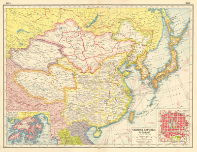
$10.04 Shipping Condition: Unspecified Location: LONDON, United Kingdom Chinese Republic& Japan; Inset map of Hong Kong; Peking Vintage colour map; Scale 1:15.000,000; Scale 1:760,000, 1920 Title of map: Chinese Republic& ... moreJapan; Inset map of Hong Kong; Peking' DATE PRINTED: 1920 IMAGE SIZE: Approx 33.0 x 44.0cm. 13 x 17.25 inches(Large) ARTIST/CARTOGRAPHER/ENGRAVER: Unsigned PROVENANCE: Harmsworth's new Atlas" Please note that virtually all antique and vintage maps and prints have been extracted from books. Atlases or newspapers. TYPE: Vintage colour map; Scale 1:15.000,000; Scale 1:760,000 VERSO: There are images and/or text printed on the reverse side of the picture. In some cases this may be visible on the picture itself(please check the scan prior to your purchase) or around the margin of the picture CONDITION: Good; suitable for framing. However. Please note: The map is printed on two adjacent pages with a fold in the centre; there is a blank space between the two parts of the map along the fold(see image) and there may be small holes along the fold where the map was bound in. Please check the scan for any blemishes prior to making your purchase. Virtually all antiquarian maps and prints are subject to some normal aging due to use and time which is not obtrusive unless otherwise stated. I offer a no questions asked return policy- see below. AUTHENTICITY: This is an authentic historic print. Published at the date stated above. I do not offer reproductions. It is not a modern copy. The term'original' when applied to a print means that it was printed at the first or original date of publication; it does not imply that the item is unique. Print' means any image created by applying an inked block to paper or card under pressure by any method including wood engraving, steel engraving, copperplate, wood cut and lithography. REMARKS: FRANCE: Gravures et Cartes anciennes. DEUTSCHLAND: Alte Lankarten und Stadt ansichten. ITALIA: Stampe& Mappe antiche. ESPAÑA: Mapas antiquos y impresiones antiguas. E and OE. Force Majeure. English law shall apply.

Buy It Now
$5.95 Shipping Condition: New Location: Las Vegas, United States The Voyages of Sir Francis Drake 1585- Cartagena Columbia Size: 24" x 32" 61 cm x 81 cm) x Also Available in 18" x 24" from our eBay ... moreStore This is a great Classic Map originally published circa 1589. This Map shows Sir Francis Drake's voyage to the city of Cartagena. Columbia during his West Indian voyage of 1585-1586. This map is a vintage stylistic print of the time featuring a sea monster trying to catch a flying fish and a large lizard. This poster. Which evokes the vivid images of a simpler time, is a custom reproduction printed on 68lb Heavyweight Enhanced Matte Art Paper. This Historic Art Print is suitable for framing. Mounting or direct display on any wall! 000 Artscape Galleries/ Posters Past More Prints and Posters Available from our eBay Store! Shipping price includes delivery confirmation. We combine shipping for multiple purchases- add $1.00 for each additional poster. All posters are professionally packaged to ensure that they arrive safely and undamaged: Your poster is first rolled and inserted into a plastic sleeve before being placed into a Heavy-Duty mailing tube for delivery. We stand behind the quality of every poster. If you are not satisfied with your purchase. Please contact us within 30 days to arrange for either an exchange or a full refund. gsrx_vers_468(GS 6.4(468)
Buy It Now
$5.95 Shipping Location: Rexford, United States This is an authentic 1897 edition, 1937 reprint from the U.S. Geological Survey and NOT a computer reproduction. Original vintage topographical map of ... morethe Paradox Lake, New York area including Hauge, Ticonderoga, Horicon, Schroon, Crown Point, NorthHudson, Pharaoh Lake River, and railroad lines. Good condition. Sheet size is 20"h x 16.5"w.Lots of intricate details and geological contours. On the back is a description of topographic symbols and map guide.Perfect for the historian, map-lover, the curious or just as a conversation starter. Wonderful and rare. Vintage maps such as this make great gifts and look great framed for the home or office!This item will ship in a tube. If you want it flat (unrolled) there will be an extra fee.
Buy It Now
$55.00 Shipping Location: Trenton, United States The top center states in part "THE HARBOR OF HAKODADI VESSO 1d JAPAN SURVEYED BY ORDER OF COMMODORE M. C. PERRY U.S.N. BY LIEUT. W. L. MAURY, G. H. PREBLE, ... moreS. NICHOLSON & A. BARBOT IN 1854". The map sight size is app.
Buy It Now
$5.95 Shipping Condition: New Location: United States Decorah, Iowa. Decorah 1870. Year: 1870. These Historic Art Prints are suitable for framing, mounting or direct display on any wall! Iowa City 1868. “Vibrant ... moreand bright! Pic does not do it justice.looks amazing!”.
Buy It Now
$17.95 Shipping Location: Cambridge, United States Approx 27 x 22". Each has its own specific set of flaws and wear. Opposite side may or may not have prints or text which may or may not be related to ... moreone shown. Your opinion may differ. In great antique condition with typical used wear. mostly on edges.
Buy It Now
$6.27 Shipping Location: WOKINGHAM, United Kingdom The Gazetteer says it is based on census info from 1891 but I believe it was published in 1894. Overall page size: 31 cm x 25.5 cm approx. with centre ... morefold.
Buy It Now
$99.03 Shipping Location: Tacoma, United States This vintage REPLOGLE World Nation Series globe is a must-have for antique collectors and map enthusiasts. Measuring 12 inches in diameter, it features ... morea raised relief and rotating design, perfect for showcasing in any home or office. The globe depicts world nations and cartographer/publisher Replogle has brought out the features of sundial in the design. The Date Range of the globe is Unknown and the Type is World. This antique piece is categorized under Antiques, Maps, Atlases & Globes, and World & Celestial Globes. Get your hands on this unique and rare globe and add a touch of history to your collection.
Buy It Now
$28.11 Shipping Location: HASLEMERE, United Kingdom Historical Map of British Isles by Janssonius-Hondius "Magnae Britanniae et Hiberniae Tabula" from "Atlas Novus.orbis terrarium" printed in Amsterdam ... morein 1638. We strive to balance the restoration and saving the overall integrity and antique appearance of the original.
Buy It Now
$5.95 Shipping Condition: New Location: Las Vegas, United States Year: 1556. This is a great old Map of Moscow by Siegmund Freiherr von Herberstein. This is the oldest map of Moscow city and shows the town as a VERY ... moreorganized assemblage of buildings centered on a walled fortress.
Buy It Now
$10.04 Shipping Condition: Unspecified Location: LONDON, United Kingdom Title of map:'Torino'. DATE PRINTED: 1924. The image below shows an enlarged cross section from the centre of the map to show the level of printed detail. ... moreThis map is folding hence the centrefold line may show on the image below.
Buy It Now
$5.95 Shipping Condition: New Location: Las Vegas, United States Orbis Terrarum - Germany. This map (Germania) is a view of Germany in the late 16th century! Year: 1570. “Vibrant and bright! Pic does not do it justice.looks ... moreamazing!”. Each of our prints are custom reproductions printed on 68lb Heavyweight Enhanced Matte Art Paper.
Buy It Now
Free Shipping Location: Monroeville, United States Date - 1787. The map includes rivers and other features along the coast line in the area, from Sierre Leone to the Cape of Three Points. Source - Universal ... moreHistory, from the Beginning of the World until the Present (the mid-1700s).
Buy It Now
$5.95 Shipping Condition: New Location: Las Vegas, United States Year: 1891. Asheville 1891. Durham 1891. Greensboro 1891. Winston-Salem 1891. Winston-Salem, North Carolina. These Historic Art Prints are suitable for ... moreframing, mounting or direct display on any wall!
Buy It Now
$49.33 Shipping Location: Elkhart, United States Antique 1659 Map - British Isles England Scotland - 16 x 21 - Hand Laid Paper. Original antique map of England Scotland British Isles. Hand colored borders. ... morePrinted on hand laid paper. Hinge mounted at top corners to mat board.
Buy It Now
$14.56 Shipping Location: Mount Morris, United States This vintage topographical sheet map of the Oolitic Quadrangle in Indiana is a rare find for map collectors and enthusiasts alike. Produced in 1946, this ... morevintage original map showcases the beautiful and intricate details of the land and terrain of Oolitic City. The map is in excellent condition, with no tears or creases and is a true testament to the quality and skill of cartographers from the past. This unique piece is perfect for anyone interested in the history and geography of Indiana and would make a great addition to any antique or map collection.
Buy It Now
$6.27 Shipping Location: SHANKLIN, United Kingdom DATE PRINTED: 1850. VERSO: There is nothing printed on the reverse side, which is plain. CONDITION: Good; suitable for framing. IMAGE SIZE: Approx 22cm ... moreby 14cm.
Buy It Now
Free Shipping Location: Sayville, United States See photo's.
Buy It Now
$90.76 Shipping Location: Hopkins, United States This is in amazing vintage condition other than a couple of little spots as shown in the picturesCondition: Pre-Owned Good
Buy It Now
$4.08 Shipping Location: HORNCASTLE, United Kingdom
Buy It Now
$5.95 Shipping Condition: New Location: United States Year: 1585. “Vibrant and bright! Pic does not do it justice.looks amazing!”. Beautiful map! Each of our prints are custom reproductions printed on 68lb ... moreHeavyweight Enhanced Matte Art Paper. These Historic Art Prints are suitable for framing, mounting or direct display on any wall!
Buy It Now
$5.95 Shipping Location: Rexford, United States This is an authentic 1897 edition, 1937 reprint from the U.S. Geological Survey and NOT a computer reproduction. Good condition. Sheet size is 20"h x ... more16.5"w. Lots of intricate details and geological contours.
Buy It Now
$10.04 Shipping Condition: Unspecified Location: LONDON, United Kingdom 'J. H. Colton's map of California'. Title of map (not printed on the page):'J. H. Colton's map of California'. Antique engraved hand coloured atlas map, ... more1864. DATE PRINTED: 1864. The image below shows an enlarged cross section from the centre of the map to show the level of printed detail.
Buy It Now
$13.29 Shipping Location: STAFFORD, United Kingdom Map is in good condition for age, see photo.
Buy It Now
$5.00 Shipping Location: Canada DATE OF ISSUE: 1924.
Buy It Now
$5.95 Shipping Condition: New Location: United States Danbury, Connecticut. Danbury 1875. Danbury 1884. Year: 1875. Bridgeport 1875. New Britain 1875. These Historic Art Prints are suitable for framing, mounting ... moreor direct display on any wall! Wolcottville 1875.
Buy It Now
$5.95 Shipping Condition: New Location: United States Delavan, Wisconsin. Delavan 1884. Year: 1884. These Historic Art Prints are suitable for framing, mounting or direct display on any wall! “Vibrant and ... morebright! Pic does not do it justice.looks amazing!”.
Buy It Now
$19.40 Shipping Location: CREWE, United Kingdom It features a detailed depiction of the Severn Estuary area and is in the format of a sheet map. The map is in good shape and has been well-preserved ... moreover the years. Whether you're a collector or a history buff, this antique map is a must-have item for your collection.
Buy It Now
$6.27 Shipping Location: WOKINGHAM, United Kingdom The Gazetteer says it is based on census info from 1891 but I believe it was published in 1894. Overall page size: 31 cm x 25.5 cm approx. with centre ... morefold.
Buy It Now
$5.95 Shipping Condition: New Location: United States Year: 1879. Mystic River 1879. New Haven 1879. Seymour 1879. These Historic Art Prints are suitable for framing, mounting or direct display on any wall! ... moreNew Haven, Connecticut. Thomaston 1879. Jewett City 1889.
Buy It Now
$5.95 Shipping Condition: New Location: United States Year: 1870. Austin 1870. Mankato 1870. Saint Peter, Minnesota. New Ulm 1870. Owatonna 1870. Saint Peter 1870. Stillwater 1870.
Buy It Now
$6.27 Shipping Location: WOKINGHAM, United Kingdom The Gazetteer says it is based on census info from 1891 but I believe it was published in 1894. Overall page size: 31 cm x 25.5 cm approx. with centre ... morefold.
Buy It Now
$5.95 Shipping Condition: New Location: Las Vegas, United States Year: 1868. Independence 1868. Saint Joseph 1868. Independence, Missouri. These Historic Art Prints are suitable for framing, mounting or direct display ... moreon any wall! Jefferson City 1869. Kansas City 1869.

Buy It Now
$10.04 Shipping Condition: Unspecified Location: LONDON, United Kingdom Richmond and Wimbledon Vintage colour map. 1921 Title of map: Richmond and Wimbledon' The image below shows an enlarged cross section from the centre ... moreof the map to show the level of printed detail: DATE PRINTED: 1921 IMAGE SIZE: Approx 21.5 x 27.0cm. 8.5 x 10.5 inches(Medium) ARTIST/CARTOGRAPHER/ENGRAVER: John Bartholomew PROVENANCE: Handy Reference Atlas of London and Suburbs" by J. G. Bartholomew; Published by John Bartholomew& Son Ltd. Edinburgh. Fourth edition TYPE: Vintage colour map VERSO: There are images and/or text printed on the reverse side of the picture. In some cases this may be visible on the picture itself(please check the scan prior to your purchase) or around the margin of the picture CONDITION: Good; suitable for framing. However. Please note: This map was originally printed as two separate pages which have been professionally joined to form a single sheet; The image shown may have been taken from a different example of this map than that which is offered for sale. The map you will receive is in good condition but there may be minor variations in the condition from that shown in the image. Please check the scan for any blemishes prior to making your purchase. Virtually all antiquarian maps and prints are subject to some normal aging due to use and time which is not obtrusive unless otherwise stated. I offer a no questions asked return policy- see below. AUTHENTICITY: This is an authentic historic print. Published at the date stated above. I do not offer reproductions. It is not a modern copy. The term'original' when applied to a print means that it was printed at the first or original date of publication; it does not imply that the item is unique. Print' means any image created by applying an inked block to paper or card under pressure by any method including wood engraving, steel engraving, copperplate, wood cut and lithography. REMARKS: FRANCE: Gravures et Cartes anciennes. DEUTSCHLAND: Alte Lankarten und Stadt ansichten. ITALIA: Stampe& Mappe antiche. ESPAÑA
Buy It Now
$10.04 Shipping Condition: Unspecified Location: LONDON, United Kingdom 'Fig. 83 Mossul and Niniveh'. Title of the map:'Fig. 83 Mossul and Niniveh'. Antique engraved sketch map. Scale 1: 77,000,000, c1885. DATE PRINTED: c1885. ... moreTYPE: Antique engraved sketch map. Scale 1: 77,000,000.
Buy It Now
$3.54 Shipping Location: Mishawaka, United States Vintage Lake Maskenozha Pennsylvania USGS Topographic Map 1969 22x27 Art and would look great in a frame. If you have any questions please ask. Feel free ... moreto visit my store for more antique maps and prints on American History and many other subjects. Most offers accepted.
Buy It Now
$62.74 Shipping Location: KNIGHTON, United Kingdom Empire map. Surroundings of Izehoe.
Buy It Now
$12.45 Shipping Location: Santa Barbara, United States 1829 Antique Map of The County of Sussex A very attractive and detailed 19th century map of Sussex with a fine vignette view of Chichester Cathedral. ... moreA very nice explanation (legend) shows the geographical and topographical features of the map.This is an original engraving with original hand color.
Buy It Now
$10.04 Shipping Condition: Unspecified Location: LONDON, United Kingdom PROVENANCE: "The Pocket Guide to The West Indies"; by Algernon Aspinall, published by Sifton, Praed & Co., Ltd., London. DATE PRINTED: 1935. CONDITION: ... moreGood; suitable for framing. The map you will receive is in good condition but there may be minor variations in the condition from that shown in the image.
$17.92 Shipping Location: LONDON, United Kingdom For condition please see the photos Combined postage available.International delivery available.
Buy It Now
$5.00 Shipping Location: Canada THIS IS AN ORIGINAL MAP. NOT A RECENT COPY OR REPRODUCTION. Origin of the map: Nouvel Atlas Illustre. Geographie Universelle" M.A. Martineau, Paris, ... moreFrance Date of issue: 1903 Size: The sheet measures 20 1/2" x 18 1/2" 52 x 40 cm) S/H: The map will be shipped by Priority International Air Mail. The shipping charge is 7.00 USD( with the tracking number) Or 5.00 USD( without the tracking number) If you wish to save 2.00 USD on the tracking number. Please let me know before you send the payment. Then wait for my invoice. Attention! There is no additional shipping charge for multiple purchases!
Buy It Now
$10.04 Shipping Condition: Unspecified Location: LONDON, United Kingdom Title of map:'Lugano'. DATE PRINTED: 1924. The image below shows an enlarged cross section from the centre of the map to show the level of printed detail. ... moreThis map is folding hence the centrefold line may show on the image below.
Buy It Now
$5.95 Shipping Condition: New Location: Las Vegas, United States Lengths of the Principal Rivers in the World Heights of the Principal Mountains in the World. This great Historic Map print shows the "Lengths of the ... morePrincipal Rivers in the World" and the "Heights of the Principal Mountains in the World" by way of an index and graphical representation.

Buy It Now
Free Shipping Location: Anaheim, United States CONDITION: corners and edges may be bent& curled from storage; yellowing from age. Map Publisher: FISH-n-MAP Co. When folded the map measures approximately ... more9 inches by 4 inches. Wiatava Lodge#13 of Orange County Council#39. Boy Scouts of America International Buyers Please Note: Customs/ Import duties. Taxes, and charges are not included in the item price or shipping charges. These charges are the buyer’s responsibility. Please check with your country's customs office to determine what these additional costs will be prior to bidding/buying. In some situations some items are not allowed to be sent to your country because of the buyers import laws. Buyers please check that an item is allowed to be sent to your country. These charges are normally collected by the shipping delivering freight company or when you pick the item up. Do not confuse them for additional shipping charges from me. The amount reported to Customs for merchandise value is the amount of the items plus the amount of shipping. We do not mark merchandise values below value or mark items as" gift" US and International government regulations prohibit such behavior. ID: map1190m Powered by SixBit's eCommerce Solution
Buy It Now
$10.04 Shipping Condition: Used Location: LONDON, United Kingdom 'Assyria and Chaldea'. Title of map:'Assyria and Chaldea'. Antique coloured engraved map. Scale 1: 3,000,000, c1885. DATE PRINTED: c1885. The image below ... moreshows an enlarged cross section from the centre of the map to show the level of printed detail.
Buy It Now
$17.63 Shipping Location: STAFFORD, United Kingdom Map is in very good condition for age, see photo.
Buy It Now
$15.55 Shipping Location: STAFFORD, United Kingdom Original map extracted from 1868 copy of John Heywood's County Atlas of England and Wales.
Buy It Now
$5.95 Shipping Condition: New Location: United States Aurora 1867. Year: 1867. Alton 1867. Belleville 1867. Bloomington 1867. Cairo 1867. Centralia 1867. Aurora, Illinois.

Buy It Now
Free Shipping Location: San Antonio, United States A FINE. ORIGINAL ANTIQUE MAP OF SOUTH AUSTRALIA Provenance The Victoria Regina Atlas Published Edinburgh& London: W. A.K. Johnston. Ltd. 1906. These ... moreare original maps that I removed from the atlas myself. They are all guaranteed to be 102 years old. Cartographer A.K. Johnston Size/ Format Map: 26 cm x 19.5 cm(10.25" x 7.75" Page: 30 c. X 25 cm(12" X 9.75" Condition Very good. The maps are bright and crisp. There is only very slight age-toning to the extreme margins. The maps are clean and free of foxing. Tears, or other compromises. Remarks This 1906 atlas. Finally published a few years after her death, was dedicated to Queen Victoria. Most of the maps had been previously published by W. A.K. Johnston in earlier atlases, and they all display the unique and unmistakable Johnston coloring and outlining. The maps from this atlas are an ideal size for inexpensive framing. Although the Victoria-Regina atlas is not very large and was published in the 20th century. It sells at $400+ thanks to the high quality of the maps and the printing. Click here for many more fine Johnston Maps Click here for many more fine maps of Australia. New Zealand and Oceania
Buy It Now
$18.98 Shipping Location: STAFFORD, United Kingdom Original map extracted from 1868 copy of John Heywood's County Atlas of England and Wales. Slight bump to bottom right corner.
Buy It Now
$14.38 Shipping Location: EXMOUTH, United Kingdom Look at the photo(s) carefully, what you see is what you will receive. Collection: FREE.
Buy It Now
$5.00 Shipping Location: Canada DATE OF ISSUE: 1926.
Buy It Now
$4.50 Shipping Location: Phoenix, United States
Buy It Now
$5.00 Shipping Location: Canada DATE OF ISSUE: 1910. ORIGIN OF THE MAP: "Southern Germany", 11th edition, published in Leipzig, Germany by Karl Baedeker, London by T. Fisher Unwin and ... moreNew York by Charles Scribner's Sons.
Buy It Now
$5.00 Shipping Location: Canada DATE OF ISSUE: 1930.
Buy It Now
$10.04 Shipping Condition: Unspecified Location: LONDON, United Kingdom Title of map:'Delhi'. The image below shows an enlarged cross section from the centre of the map to show the level of printed detail. This map is folding ... morehence the centrefold line may show on the image below.
Buy It Now
$3.99 Shipping Location: Quincy, United States Details: World map from 1963 featuring major cities, oceans, and a guide to UN-affiliated countries. Item: World Map. This is an authentic map. General ... moreInfo.
Buy It Now
$13.29 Shipping Location: GLASGOW, United Kingdom Plan of St Andrews - Published by John Bartholomew. Based on plan prepared by the Burgh Engineer and reproduced with permission and by the courtesy of ... moreSt Andrews Town Council.
Buy It Now
$7.00 Shipping Location: Deland, United States Map by A. Hoen & Co (Baltimore).
Buy It Now
$6.90 Shipping Location: Jasper, United States Known for being one of the oldest and most respected publishing houses in Germany, the Bibliographisches Institut specialized in authoritative reference ... moreworks. I believe they deserve to be appreciated by fellow collectors rather than gathering dust in storage.
|
|
|
|