|
|
Order by: Available to: This site contains affiliate links for which I may be compensated
|
Free Shipping Location: Old Orchard Beach, United States This Map was removed from a 1924 Atlas and is in good acceptable condition. ~ 1924/100720. Including Hundreds of RareCivil War. 90+ years of aging. Study ... morethe photos carefully, this is the actual map you.
Buy It Now
Free Shipping Location: Schertz, United States This Map was removed from a 1887 Cram's Atlas and is in good acceptable condition. The map is not " new " or in " new " condition, it was printed in 1887. ... moreThe map is not dated. Study the photos carefully, this is the actual map you will receive.
Buy It Now
$4.00 Shipping Location: Harborton, United States ANTIQUE 1930'S ANIMATED MINNESOTA STATE MAP. This neat Minnesota picture map features sketches of people, mountains, animals, vegetation, and more. It ... moreis in very good condition - note crease and age spot on the top right corner, there is text on the reverse side.
Buy It Now
$11.85 Shipping Location: Dover, United States Issued 1793, Boston by Thomas & Andrews for Morse. Engraved by Amos Doolittle. Only the fourth map of the West Indies published within the United States.
Free Shipping Location: Schertz, United States This Map was removed from a 1967 Rand McNally Atlas and is in good condition. Including Hundreds of RareCivil War. This map is not dated. This map in ... morenot new or in new condition. It was printed in 1967.
Buy It Now
$20.40 Shipping Location: Newtown, United States Offering a vintage map of the United States. Originally created by Abel Buell in 1784. This old map is a more recent reproduction from the original at ... morethe New Jersey State Historical Society by American Heritage. Printed in Switzerland. The map measures 19" s 24". It has some yellowing, small markings, little tearing and creasing, that add to its historic look. Please see photos for details.
Free Shipping Location: Old Orchard Beach, United States This Map was removed from an 1909 Atlas and is in good acceptable condition. Including Hundreds of RareCivil War. 120+ years of aging. Study the photos ... morecarefully, this is the actual map you. will receive.
Buy It Now
$6.95 Shipping Location: Dover, United States Issued 1868, New York by F.W. Beers. This fragile map will require careful handling, but remains worthy of framing and display. Uncommon and detailed ... moremid 19th century lithographed map with original hand color.
Buy It Now
$6.95 Shipping Location: Dover, United States Issued 1832, Boston by S. G. Goodrich. Engraved by G. Boynton. Western States. There are different variant versions of this map, this example being the ... morefirst issue.
Free Shipping Location: San Antonio, United States This Map was removed from a 1901 Cram's Atlas of the World. The map is not " new " or in " new " condition, it was printed in 1901. ~ CRAM1901/071122. ... moreIncluding Hundreds of RareCivil War. The full page is approx.
Buy It Now
$3.50 Shipping Location: Allensville, United States COULDN'T FIND ANOTHER LIKE THIS! This is a scarce 1984 GENERAL SOIL MAP OF THE NORTHEASTERN UNITED STATES, 24" X 30" folded to 6 x 7 1/2". "Compiled by ... moreHorace Smith, Chairman; General Soil Map Committee; Northeastern (Cooperative) Soil Survey Conference - 1980.".
Buy It Now
Free Shipping Location: Bakersfield, United States YOU RECIEVE WHAT YOU SEE. HARD TO FIND MAP FOR THE SERIOUS COLLECTOR OR FOR DECO IN THE HOUSE, OFFICE, OR MAN CAVE. THIS MAP SHOWS AND BORDERS TEXAS, ... moreLOUISANA, MISSISSIPPI AND ALABAMA. MAP HAS NO WRITING ON IT.
Buy It Now
$6.00 Shipping Location: Corunna, United States This is an original 108 year old map, not a copy or reprint.
Buy It Now
$6.80 Shipping Location: Rochester, United States Atlas pages are authentic originals in good condition as shown in photos.
Buy It Now
$11.85 Shipping Location: Dover, United States Early 20th century lithographed coastal survey with lovely hand color. Printed on thin sturdy bond paper. Boston Harbor, Massachusetts. Issued 1910, Washington, ... moreD.C by the Coast & Geodetic Survey (but appearing/ issued elsewhere).
Buy It Now
$6.95 Shipping Location: Dover, United States Issued 1856, Washington by United States Coastal Survey. Preliminary Chart of San Pablo Bay California. Detailed mid 19th century lithographed coastal ... moresurvey. Reference includes dates of survey, as well as yearly tidal information.
Buy It Now
$6.50 Shipping Location: Corunna, United States This is a very beautifully detailed engraving with nice colors. Map is in very good condition.
Buy It Now
Free Shipping Location: Schertz, United States This Map was removed from a 1938 Pictorial Atlas and is in good acceptable condition. The map is not " new " or in " new " condition, it was printed in ... more1938. The map is not dated. Study the photos carefully, this is the actual map you will receive.
Buy It Now
$6.95 Shipping Location: Dover, United States Issued 1893, United States by D.H. Hurd. South Part of New London Co. Late 19th century lithographed county map with original hand color. Original center ... morefold as issued.
Buy It Now
$11.85 Shipping Location: Dover, United States Issued 1868, New York. Litho by W.V. Rogers & Co for Joseph Shannon.
Free Shipping Location: Schertz, United States This Map was removed from a 1860 Warren's Atlas and is in good acceptable condition. The map is not " new " or in " new " condition, it was printed in ... more1860. The map is not dated. Study the photos carefully, this is the actual map you will receive.
Buy It Now
$6.95 Shipping Location: Dover, United States Issued 1788, London by Kitchin. Uncommon late 18th century engraved map with attractive hand color. The World from the Best Authorities. Original fold ... morelines as issued.
Free Shipping Location: Marana, United States This Map was removed from a 1901 Atlas and is in good acceptable condition. ~ NATIONAL1901/020821. Including Hundreds of RareCivil War. 110+ years of ... moreaging. Study the photos carefully, this is the actual map you.
Buy It Now
$5.50 Shipping Location: Easton, United States Washington: Norris Peters, 1895. Fine copy, folded, as issued.
Free Shipping Location: Marana, United States This Map was removed from a 1903 Atlas and is in good acceptable condition. ~ 20THCENTURY1903/032321. Including Hundreds of RareCivil War. 110+ years ... moreof aging. Study the photos carefully, this is the actual map you.
Buy It Now
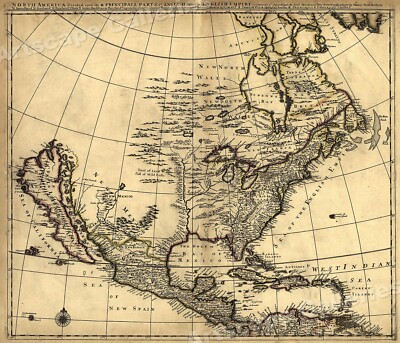
$5.95 Shipping Condition: New Location: Las Vegas, United States North America 1685 Size: 24" x 28" 61 cm x 86 cm) x Also Available in from our eBay Store This is a great Classic Map originally Published circa ... more1685. This Map shows what was known of America(North America) in1685. The wording reads: North America divided into its III principall parts. Features include: New North Wales" Canada) Bay of Mexico" Gulf of Mexico) Sea of the English Empire" Atlantic Ocean) West Indian Sea" Caribbean) Sea of California" Sea of New Spain" Pacific Ocean) New Mexico" Western United States) and"Tract of Land full of Wild Bulls" Great Plains) This poster. Which evokes the vivid images of a simpler time, is a custom reproduction printed on 68lb Heavyweight Enhanced Matte Art Paper. This Historic Art Print is suitable for framing. Mounting or direct display on any wall! 000 Artscape Galleries/ Posters Past More Prints and Posters Available from our eBay Store! Shipping price includes delivery confirmation. We combine shipping for multiple purchases- add $1.00 for each additional poster. All posters are professionally packaged to ensure that they arrive safely and undamaged: Your poster is first rolled and inserted into a plastic sleeve before being placed into a Heavy-Duty mailing tube for delivery. We stand behind the quality of every poster. If you are not satisfied with your purchase. Please contact us within 30 days to arrange for either an exchange or a full refund. gsrx_vers_468(GS 6.4(468)
Buy It Now
Free Shipping Location: Monroeville, United States Date - 1886. Condition - Quite Nice, small light border stain lower part, a fold split in the center was repaired on the reverse with neutral archival ... moretape. Good Luck!
Buy It Now
Free Shipping Location: San Antonio, United States This Map was removed from a 1864 Atlas and is in good acceptable condition. Including Hundreds of RareCivil War. Study the photos carefully, this is the ... moreactual map you will receive. The page is approx.
Buy It Now
$4.00 Shipping Location: Harborton, United States This is an antique United States map which was carefully removed from a Rand McNally atlas published in 1911. It is in very good condition - note there ... moreis another map on the reverse side. ANTIQUE MAP OF THE UNITED STATES.
Buy It Now
$4.13 Shipping Location: Palm Coast, United States 1911 Vintage Hammonds Pictorial Atlas of the World Map. United States, on one side, Maine, on the other side. Vintage map from families Atlas. Map measures ... more8 X 11 from the black boarders on the map. Full page measurements are 10 1/4 X 13 1/4. Photo of matted And framed map of the State of Florida is just an example. SHIPPING: Map will be shipped through media mail by USPS. REMINDER: Considering the age of the map, the edges are worn, so framing would require removing the worn areas.
Buy It Now
Free Shipping Location: San Antonio, United States This Map was removed from a 1891 Cram's Atlas and is in very good condition. This map is not " new " or in " new " condition, it was printed in 1891. ... moreIncluding Hundreds of RareCivil War Period United States.
Free Shipping Location: Marana, United States This Map was removed from a 1891 Atlas and is in good acceptable condition. ~ GASKELL1891/020921. Including Hundreds of RareCivil War. 130+ years of aging. ... moreStudy the photos carefully, this is the actual map you.
Buy It Now
Free Shipping Location: Augusta, United States "An Authentic Original Map Not A Reproduction".
Buy It Now
Free Shipping Location: Schertz, United States This Map was removed from an 1894 Atlas and is in good acceptable condition. The map is not " new " or in " new " condition, it was printed in 1894. The ... moremap is not dated. Study the photos carefully, this is the actual map you will receive.
Buy It Now
Free Shipping Location: Schertz, United States This piece was removed from an 1887 Atlas and is ingood acceptable condition. This original map is not "new" or in "new" condition, it was printed in ... more1887. Study the photos carefully, this is the actual map you will receive.
Buy It Now
Free Shipping Location: Schertz, United States This Map was removed from an 1882 Rand McNally Atlas and is in very good condition. This map is not dated. This map in not new or in new condition. It ... morewas printed in 1882. Including Hundreds of RareCivil War.
Buy It Now
$21.84 Shipping Location: Erie, United States We do not know when this was created, but are estimating in the 1800's since the translation is "Map of the Northern Part of the United States". Antique ... moreMap of the Northern Part of the United States.
Free Shipping Location: Old Orchard Beach, United States This Map was removed from an 1907 Atlas and is in good acceptable condition. Including Hundreds of RareCivil War. 120+ years of aging. Study the photos ... morecarefully, this is the actual map you. will receive.
Buy It Now
Free Shipping Location: San Antonio, United States This Map was removed from a 1875 Atlas and is in good acceptable condition. pencil marks & brittle paper from over 140+ years of aging. ~ NYPLAT1875/02922. ... moreStudy the photos carefully, this is the actual map you will receive.

Buy It Now
$5.95 Shipping Condition: New Location: Las Vegas, United States Colton's Railroad and Military Map of the United States. Mexico, and the West Indies Size: 24" x 32" 61 cm x 81 cm) x Also Available in ... more18" x 24" from our eBay Store This is a great Classic Map originally Published circa 1862. This is a detailed general map of portions of North America. Framed in decorative borders. Showing drainage, international and state boundaries, cities and towns, forts. Railroads in operation, and proposed lines. Insets: Colton's map of the Americas, Africa and a portion of Europe showing the Atlantic and part of the Pacific oceans. New Orleans and delta of the Mississippi. Louisiana.Mobile harbor, Alabama. Key West and Tortugas. Florida reefs.Wilmington and vicinity, N. Carolina. Beaufort and vicinity. N. Carolina.Norfolk, fortress Monroe, James River, Richmond, Petersburg&c&c. Map of Charleston. Port Royal& Savannah vicinities. Washington, Manassas Junction. Harpers Ferry, Baltimore, Annapolis This poster. Which evokes the vivid images of a simpler time, is a custom reproduction printed on 68lb Heavyweight Enhanced Matte Art Paper. This Historic Art Print is suitable for framing. Mounting or direct display on any wall! 000 Artscape Galleries/ Posters Past More Prints and Posters Available from our eBay Store! Shipping price includes delivery confirmation. We combine shipping for multiple purchases- add $1.00 for each additional poster. All posters are professionally packaged to ensure that they arrive safely and undamaged: Your poster is first rolled and inserted into a plastic sleeve before being placed into a Heavy-Duty mailing tube for delivery. We stand behind the quality of every poster. If you are not satisfied with your purchase. Please contact us within 30 days to arrange for either an exchange or a full refund. gsrx_vers_468(GS 6.4(468)
Free Shipping Location: Marana, United States Included with each map is a reference card indicating State or Country, Map type - Plat / Atlas Book. This Map was removed from an 1894 Atlas and is in ... moregood acceptable condition. Including Hundreds of RareCivil War.
Free Shipping Location: Old Orchard Beach, United States This Map was removed from an 1909 Atlas and is in good acceptable condition. Including Hundreds of RareCivil War. 120+ years of aging. Study the photos ... morecarefully, this is the actual map you. will receive.
Free Shipping Location: Schertz, United States This Map was removed from a 1910 Atlas and is in good acceptable condition. Including Hundreds of RareCivil War. Study the photos carefully, this is the ... moreactual map you.
Buy It Now
$5.85 Shipping Location: Saint Petersburg, United States Original authentic hand colored antique "MAP OF THE MIDDLE STATES AND PART OF THE SOUTHERN". By: S. Augustus Mitchell. Published in Mitchell's School ... moreand Family Geography, 1853. Minor archival repair bottom center border, not noticeable.
Buy It Now
$6.00 Shipping Location: North Wales, United States 1912 ANTIQUE CRAM'S MODERN NEW CENSUS ATLAS MAP-CINCINNATI-OHIO-UNITED STATES ORIGINAL ANTIQUE ATLAS MAP PLEASE SEE PHOTOS AS PART OF THE DESCRIPTION ... moreCONDITION: MAP IS IN GOOD CONDITION. SIZE: APPROXIMATELY 15" X 22.5" SHIPPING: U.S. FIRST CLASS RATE - $6.00 - ANY ITEM WHICH SELLS FOR OVER $100 WILL REQUIRE INSURANCE WE COMBINE SHIPPING FOR MULTIPLE WINS. THANK YOU FOR YOUR INTEREST IN OUR AUCTIONS!.
Buy It Now
$6.95 Shipping Location: Dover, United States Geological Map of the United States Showing the Distribution of the Geologic Systems So Far As Known. Issued 1898, United States by Johnson. Map by John ... moreB. Torbert under WJ McGee. Late 19th century color lithographed geological map.

Free Shipping Location: Schertz, United States This Listing is for an Unframed ORIGINAL(not a reprint) map as pictured above and detailed above. Each Page has TWO maps one on each side. Original Atlas ... moreTitle General Atlas of the World Containing Large Scale Maps of every State. Territory and Country in the World. With a carefully prepared Historical and Descriptive Sketch of each. Together with an Alphabetically Arrange List of Every Railroad Station in the United States. Canada and Mexico, Principal Cities, Lakes, Rivers, Islands and Mountain Peaks of the Entire Globe, and other Statistical Tables on all Geographical Subjects. 1889 Engraved by Rand McNally Approximate Image Size Map size is 9 X 12 inches WE HAVE MANY HISTORIC MAPS AND OTHER ITEMS ON MANY DIFFERENT SUBJECTS Please check our store for additonal products FREE SHIPPING BY MAIL(GENERALLY 2 TO 5 DAY DELIVERY) FOR ANY NUMBER OF MAPS SHIPPED IN THE US. Due to huge recent increases in international shipping costs and issues with deliverly I no longer ship outside the US. To protect it during shipment this map will be shipped rolled in a heavy tube and protected by a plastic sleeve. IF YOU ARE UNHAPPY WITH YOUR PURCHASE SIMPLY RETURN IT AND WE WILL REFUND YOUR MONEY. Ad copyright 2015 All Rights Reserved Powered by The free listing tool. List your items fast and easy and manage your active items.
Buy It Now
$6.95 Shipping Location: Dover, United States Issued 1853, New York by David Burgess & Co. Mid 19th century engraved map with original hand color.

Free Shipping Location: Schertz, United States This Listing is for an Unframed ORIGINAL(not a reprint) map as pictured above and detailed above. Each Page has TWO maps one on each side. Original Atlas ... moreTitle General Atlas of the World Containing Large Scale Maps of every State. Territory and Country in the World. With a carefully prepared Historical and Descriptive Sketch of each. Together with an Alphabetically Arrange List of Every Railroad Station in the United States. Canada and Mexico, Principal Cities, Lakes, Rivers, Islands and Mountain Peaks of the Entire Globe, and other Statistical Tables on all Geographical Subjects. 1889 Engraved by Rand McNally Approximate Image Size Map size is 9 X 12 inches WE HAVE MANY HISTORIC MAPS AND OTHER ITEMS ON MANY DIFFERENT SUBJECTS Please check our store for additonal products FREE SHIPPING BY MAIL(GENERALLY 2 TO 5 DAY DELIVERY) FOR ANY NUMBER OF MAPS SHIPPED IN THE US. Due to huge recent increases in international shipping costs and issues with deliverly I no longer ship outside the US. To protect it during shipment this map will be shipped rolled in a heavy tube and protected by a plastic sleeve. IF YOU ARE UNHAPPY WITH YOUR PURCHASE SIMPLY RETURN IT AND WE WILL REFUND YOUR MONEY. Ad copyright 2015 All Rights Reserved Powered by The free listing tool. List your items fast and easy and manage your active items.
Buy It Now
Free Shipping Location: Dayton, United States "Total Number Of Thunderstorms Reported For February, 10-Year Period, 1904-1913, Inclusive," July, 1915,"Total Number Of Thunderstorms Reported For March, ... more10-Year Period, 1904-1913, Inclusive," July, 1915,"Total Number Of Thunderstorms Reported For April, 10-Year Period, 1904-1913, Inclusive," July, 1915.
Buy It Now
$4.13 Shipping Location: Mason, United States Quadrangle Oahu, Hawaii; Western United States 1:250,000. US Geological Survey Topography Map,1970. In very good condition. One small tear along top of ... moremap. See pictures.
Free Shipping Location: Marana, United States This Map was removed form an 1893 Atlas and is in good acceptable condition. Including Hundreds of RareCivil War. 120+ years of aging. Study the photos ... morecarefully, this is the actual map you. will receive.
Free Shipping Location: Marana, United States This Map was removed from a 1911 Atlas and is in good acceptable condition. ~ CRAM1911/021021. Including Hundreds of RareCivil War. 110+ years of aging. ... moreStudy the photos carefully, this is the actual map you.
Free Shipping Location: Marana, United States This Map was removed from a 1864 Atlas and is in good ( STAINS ) acceptable condition. ~ COLTON1864/013021. Including Hundreds of RareCivil War. 150+ ... moreyears of aging. Study the photos carefully, this is the actual map you.
Buy It Now
Free Shipping Location: Schertz, United States This Map was removed from an 1882 Rand McNally Atlas and is in very good condition. This map is not dated. This map in not new or in new condition. It ... morewas printed in 1882. Including Hundreds of RareCivil War.
Buy It Now
Free Shipping Location: Schertz, United States This Pictorial Map is in very good condition. The image is approx. The map is not " new " or in " new " condition, it was printed in the 1928. The map ... moreis not dated. Study the photos carefully, this is the actual map you will receive.
$16.00 Shipping Location: Poland Date of issue: 1782 (dated map). THIS IS AN ORIGINAL MAP, NOT A RECENT COPY OR REPRODUCTION. by Vaugondy R., engr. by Mounier S., publ. by Leroy A., Lyon ... more(France). HAND COLORED.
Free Shipping Location: Schertz, United States This Map was removed from an 1890 Rand Mc NALLY Atlas and is in good acceptable condition. The map is not " new " or in " new " condition, it was printed ... morein 1890. The map is not dated. Study the photos carefully, this is the actual map you will receive.
Buy It Now
$11.85 Shipping Location: Dover, United States Issued 1851, United States for U.S. Coast Survey. Third Edition. Engraved by Rolle, Dankworth, et. of the Western Coast of the United States from Monterey ... moreto the Columbia River. Mid 19th century lithographed detailed coastal survey.
Buy It Now
$11.85 Shipping Location: Dover, United States Map engraved by Rapkin. Vignettes drawn by H. Whitten & engraved by J. Rogers. Lovely mid 19th century engraved decorative map with original outline hand ... morecolor.
|
|
|
|
1987 WESTERN UNITED STATES ROAD MAP- EXXON OIL- COMPLEX INDEX/SPECIAL AREA MAPS
I HAVE THIS 1987 WESTERN UNITED STATES ROAD MAP- EXXON OIL- FEATURING: COMPLEX INDEX/SPECIAL AREA MAPS/RECREATION AREAS/ POINTS OF INTEREST TEXT. IT IS A 1987 BUT IT IS CRISPY NEW- NO TEARS AND NO STAINS. SMOKE FREE AND PET FREE HOME. CHECKOUT THE MANY ITEMS I WILL BE POSTING.
|
|
|
1987 EASTERN UNITED STATES ROAD MAP- EXXON OIL- COMPLEX INDEX/SPECIAL AREA MAPS
I HAVE THIS 1987 EASTERN UNITED STATES ROAD MAP- EXXON OIL- FEATURING: COMPLEX INDEX/SPECIAL AREA MAPS/RECREATION AREAS/ POINTS OF INTEREST TEXT. IT IS A 1987 BUT IT IS CRISPY NEW- NO TEARS AND NO STAINS. SMOKE FREE AND PET FREE HOME. CHECKOUT THE MANY ITEMS I WILL BE POSTING.
|
|
|
NATIONAL GEOGRAPHIC WORLD & UNITED STATES POLITCAL EXECUTIVE MAPS 43 X 30 INCHES
BOTH ARE 43 X 30 LKE NEW PRISTINE SCALE IS 1: 4.560,000 ANY ITEM SHIPPED USPS PRIORITY IS AUTOMATICALLY INSURED UP TO $50.00 TRACKING IS PROVIDED ANY ITEMS SHIPPED FED EX ARE INSURED UP TO $100.00 AND DOES PROVIDE TRACKING ALL PA RESIDENTS PLEASE PAY APPLICABLE SALES TAX IF ITEM IS NOT PAID BY THE 4TH DAY AFTER PURCHASE AN UNPAID ITEM NOTICE WILL BE SENT PLEASE INTEND TO PAY WITHIN 3 DAYS WHEN YOU WIN PLEASE PAY RIGHT AWAY ON BUY IT NOW ITEMS WE DO OFFER A RETURN POLICY ON MOST ITEMS WE DO COMBINE SHIPPING COST WITH OTHER ITEMS WE DO NOT O FFER PARTIAL REFUNDS ON ANY ITEMS WE DO SHIP INTERNATIONAL AND OFFER BOTH THE FIRST CLASS AND PRIORITY HOWEVER. PRIORITY OFFERS TRACKING AND IS A MUCH FASTER SHIPPING METH OD THAN FIRST CLASS
|
|
|
1952 United Airlines Rainbow Sunshine Flight Weather Maps Mainliner GREAT ART Ad
| 1952 United Airlines Rainbow Sunshine Flight Weather Maps Mainliner GREAT ART Ad, Grade per Six Grade System: Near Mint Size in English units(approximate) 8" X 10 3/4" Size in metric units(approximate) 20 cm x 27 cm Product source: Magazine Miscellaneous Information: One page print advertisement To find similar items in our store. Please. You will be taken to one of the largest ad stores on eBay and should be able to find a selection of many pieces to complement your collection. In our 15 years serving the eBay community. We have been able to amass a HUGE selection. Remember that we do combine shipping and are running specials often. We use a that is used by most all paper ephemera collectors and grading specialists. We decided that we would stick to something that is understood universally. We grade our product very ... morestringently to make certain that you are well pleased with everything you receive. That is why we have a 100% money back guarantee! We have shipped to over 70 countries and our feedback shows that our customers are very happy with their beautiful art. Our advertising shows up in some very interesting places all over the world. Leaders of countries, television and theater props, museum and gallery exhibits, major department stores and corporations, restaurants, pubs, bar decor, private collections and educational institutions. We ALWAYS appreciate it when someone can give us some history behind a particular ad or when our customers tell us how they used their ads. Interior design professionals and homeowners alike have shared some amazing artwork and creative design with us. Some of the mid century, 50's, 60's and 70's graphic design and pop art looks so amazing when added to your wall as an individual hanging or a collage. Our vintage advertising is carefully chosen and removed from the original publications. We would never sell a copy or any type of reproduction. Our shipping is the best in the business and packaged with pride and care. Your order is securely shippe
|
|
|
Lot Of Vintage Exxon Maps New Jersey Pennsylvania Eastern United States 1976
Lot Of Vintage Exxon Maps New Jersey Pennsylvania Eastern United States. Up for sale are 3 New Jersey. 1 Pennsylvania, and 1 eastern United States maps. Some are from the bicentennial. Excellent condition. Please see photos. Please ask question before bidding. All sales final. My home is smoke and pet free. USA sales only. If paying by Paypal, will ship to confirmed addresses only. Thanks and please check out my other items, happy shopping!
|
|
|
1950s UNITED AIR LINES MAPS OF THE MAIN LINE AIRWAY ROUTE MAP
COOL OLD BOOKLET. 31 PAGES SHOWING ALL THE ROUTES UNITED AIR LINES, NO DATE BUT LOOKS TO BE FROM 1950s, OVERALL IN GREAT SHAPE, NO MILDEW SMELL AND KEPT IN SMOKE FREE HOME.
|
|
|
Highway Maps (2) of Canada & Northern United States - 1958 and 1965
Highway Maps of Canada and Northern United States(2) 1958& 1965 1. Canadian Government Travel Bureau map- Ottawa. Canada. Display Eastern and Western sheets on opposite sides of map. COMPILED. REPRODUCED, AND LITHOGRAPHED IN. CANADA. BY ROLPH CLARK STONE, LTD. TORONTO. Copyrighted in 1958. Measures: 37.25" x 20.5" Authentic and original. CONDITION. Fine gently used vintage condition. 3 tiny holes found at the center fold. 2" is written on the title page; a transparent green. Marker line follows a route from Seattle to Winnipeg. see photo) Color is excellent. 2. Canadian Government Travel Bureau map- Ottawa. Canada published in 1965. Printed in Canada. Published by authority of The Honorable Mitchell W. Sharp. Minister of Trade and Commerce. Reg. 44-197-P. Measures: 37" x 24" Authentic and original. CONDITION. ... moreExcellent condition. No rips. Holes, or writing; color is very fine. Appears never to have been opened. SHIPPING maps will be shipped via First Class Parcel in the U.S. and First Class Parcel International out of country; weight is 4 oz. 1.RcmdId ViewItemDescV4,RlogId p4%60bo7%60jtb9%3Fuk.rp73%28b0g%60%60%3E1-14b6b5eccf7-0x107-
|
|
|
Vintage AAA AMERICAN AUTO ASSOC UNITED STATES Oil Gas Station Road Maps~1941
Vintage TEXACO Oil Gas Station Road Map. UNITED STATES. 1941. Any questions. Please contact. See daisyjane-store& eddiesexchange1 for more vintage road maps. We do ship USPS through Global Shipping per their policies and to Canada. Ask about Combine Shipping for multiple map purchases. Note: If you from Canada and have problems pulling up shipping costs. Single maps are running approximately 5.00 to ship. We will be happy to weigh additional maps and let you know a price. It may not be possible to ship through ebay and we may have to provide you with tracking info. via a message. Please see both stores listed above, we do have quite a few Canadian maps and will be adding more.
|
|
|
1857 Emory Boundary Surveys Mexico United States Maps Plates Beautiful Binding
Emory. William. REPORT ON THE UNITED STATES AND MEXICAN BOUNDARY SURVEY, MADE UNDER THE DIRECTION OF THE SECRETARY OF THE INTERIOR. Washington: Cornelius Wendell, Printer, 1857. 34th Congress, 1st Session. Volume 1, Part 1, 248 pages, Part 2, 174 pages. Volume 2, Part 1, Botany of the Boundary, 270 pages, Part 2, Cactacae of the Boundary, 68 pages. Volume 3, Mammals, Birds, Reptiles, Fish. Minor internal foxing. Marbled boards with leather spine and corners. Marbled end pages and all edges marbled. Bookplate. Beautiful copies of this monumental work. This particular binding with with 3/4 leather, marbled end pages and marbled edges not described or listed in BASIC TEXAS BOOKS. All plates and maps including folding are present. Powered by The free listing tool. List your items fast and easy and manage your active items.
|
|
|
DeLorme Street Atlas USA 2 CD Set Hobby Software for Maps made in United States
This CD set is playable because the CD's have rarely been used. There are no cracks on the Cassette and no scratches on the CD's. So this software is ready to be used.
|
|
|
Vintage GULF Eastern United State Oil Gas Station Road Maps Map~1940's-1950's
Vintage GULF Oil Gas Station Road Map. Eastern United States. Should be 1940's or 1950's. Any questions. Please contact. See daisyjane-store& eddiesexchange1 for more vintage road maps. We do ship USPS through Global Shipping per their policies and to Canada. Ask about Combine Shipping for multiple map purchases. Note: If you from Canada and have problems pulling up shipping costs. Single maps are running approximately 5.00 to ship. We will be happy to weigh additional maps and let you know a price. It may not be possible to ship through ebay and we may have to provide you with tracking info. via a message. Please see both stores listed above, we do have quite a few Canadian maps and will be adding more.
|
|
|
Vintage Maps & Brochures Oregon, Rockefeller Center, United Hawaii, WA, Grayline
Maps. Brochures to sights and locations from the 1950s-60s 1. The Grayline- see Oakland and San Francisco with smaller items for Hotels and Restaurants 2. Oregon Highway Map 3. Rockefeller Center with pictures and what to see 4. Portland Street and Vicinity Maps from CHEVRON Supreme Gasoline 5. United Air Lines Brochure- Vacations in Hawaii 6. Bellingham. Washington, on Fabulous upper Puget Sound 7. Victoria BC with small map and sights to see; picture of Shirley Temple with an 11 lb Salmon she caught. Made in USA Please view the pictures as part of the description. Thank you for stopping in; please ask questions prior to the end of bidding; if you decide to bid and win; please pay within 3 business days and your item will be sent promptly upon payment. Feedback will be provided once I know your item has reached you safely. If your country ... morehas specific shipping requirements; please request a shipping cost
|
|
|
1884 SPAULDING FAMILY ATLAS UNITED STATES & WORLD MAPS, RR SYSTEM & POST ROUTES
NEW INDEXED FAMILY ATLAS OF THE UNITED STATES WITH MAPS OF THE WORLD. A compendium of Geographical knowledge. Compiled from the Latest Authentic Sources, showing in Detail the RAILWAY SYSTEM AND POST ROUTES, with historical and Descriptive Matter of the STATES AND TERRITORIES OF THE UNITED STATES. Accompanied by Large Scale Maps and General Remarks Pertaining to the Geographical Position of EVERY COUNTRY UPON THE FACE OF THE GLOBE.An attractive Feature is Made of the Statistical Matter and Population Returns from THE LAST CENSUS. Prepared expressly for and adapted to the wants of THE FAMILIES OF AMERICA by J.R. SPAULDING& Co. 106 Court Street. Boston, Mass. 1884. 112 pages. Binding and cover are in poor condition but pages are in good condition and could be framed. Information is very interesting
|
|
|
Folio MAPS Canada & United States Boundary 38 MAP Atlaas 1906-17
Ohio Book Consortium presents. Joint Maps of the Internationa; Boundary Between United States and Canada Along the 141st Meridian from the Arctic Ocean to Mt. St. Elias Author: Publisher: Release Date: Seller Category: Qty Available: 1, Condition: Used: Good, Sku: 001213, Notes: 38 sheets plus a general map and 2 profiles surveyed 1907- 1913 Under the Convention Signed at Washington 1906. Elephant Folio. Ex-library copy with usual marks to binding. Just a trace of coal dust along top edges. Otherwise interior is clean and tight. Maps unmarked.Your purchase benefits the Friends of the Public Library of Cincinnati and Hamilton County. We ship every business day. All books ship in cardboard bookfolds. Don't forget to check out other great deals in our eBay Store!
|
|
|
Vintage SINCLAIR UNITED STATES Oil Gas Station Road Maps Map~1950 Census
Vintage SINCLAIR Oil Gas Station Road Map. United States. Based on the 1950 Census. Any questions. Please contact. See daisyjane-store& eddiesexchange1 for more vintage road maps. We do ship USPS through Global Shipping per their policies and to Canada. Ask about Combine Shipping for multiple map purchases. Note: If you from Canada and have problems pulling up shipping costs. Single maps are running approximately 5.00 to ship. We will be happy to weigh additional maps and let you know a price. It may not be possible to ship through ebay and we may have to provide you with tracking info. via a message. Please see both stores listed above, we do have quite a few Canadian maps and will be adding more.
|
|
|
6 Sectional Aeronautical Chart Maps, 1957 /1958, United States cities
They are all in very good shape. please ask questions if needed. Estate Sale Find
|
|
|
3 VINTAGE 1970s GULF OIL MAPS-UNITED STATES (1974)-CLEVELAND (1974)-FLORIDA (197
3 VINTAGE 1970s GULF OIL MAPS-UNITED STATES(1974)CLEVELAND(1974)FLORIDA(1972) EXCELLENT! NO TEARS OR HOLES! COLOR IS FANTASTIC! NORMAL WEAR AND TEAR. BENDS ON CORNERS. a;06d2.RcmdId ViewItemDescV4,RlogId p4%60bo7%60jtb9%3Fuk.rp73%28%3Ea%3B06d2-14b74e0df83-0x10b-
|
|
|
Vintage SOHIO UNITED STATES Oil Gas Station Road Maps
Vintage SOHIO Oil Gas Station Road Map. UNITED STATES. Did not see date. Any questions. Please contact. See daisyjane-store& eddiesexchange1 for more vintage road maps. We do ship USPS through Global Shipping per their policies and to Canada. Ask about Combine Shipping for multiple map purchases. Note: If you from Canada and have problems pulling up shipping costs. Single maps are running approximately 5.00 to ship. We will be happy to weigh additional maps and let you know a price. It may not be possible to ship through ebay and we may have to provide you with tracking info. via a message. Please see both stores listed above, we do have quite a few Canadian maps and will be adding more.
|
|
|
Lot of 13 1970's - 90's United States Gas Station Road Maps And Britain Maps
Lot of 13 1970's- 90's United States Gas Station Road Maps And Britain Maps- mint condition. Some of them are in good used condition, some of them have handwritings or creases little damage- from Exxon. Mobil, gulf, shell- please check photos carefully. Thanks
|
|
|
UNITED NATIONS WAR ATLAS WWII Battlefronts Targets Troop Movement War Maps
Size: 12 1/4 x 9 1/4 inches approx 10 pages of b&w war maps Color standard atlas maps of the world in center condition: some wear and rippling at bottom edge light ink staining at bottom binding solid Shipping 3.00 in the US other destinations contact us for shipping info or use shipping calculator. we combine shipping at 50 cents for each additional item. If shipping doesn't combine. Please wait for a revised invoice Please check our listings regularly. We are regularly posting more vintage paper and other items. Also check my partner's site for more great paper and stamps. Ebay id: cf9100 Thanks for looking dc115.RcmdId ViewItemDescV4,RlogId p4%60bo7%60jtb9%3Feog4d71f%2B%3F4f%3E-14b7a574c27-0x10f-
|
|
|
Vintage Lot of 2 United States Wall Maps by Hammond-Award & Contemporary
Believed to date to 1960s Award Map has pin holes at corners; otherwise both in EXC condition.
|
|
|
Antique Maps, Samuel Butler c.1863 #21 United States
Not a reproduction! An original color map from"An Atlas of Modern Geography" by Samuel Butler. Published in London. England in 1863. These are a significant historical look at the world of over 150 years ago! Handsome when framed and grouped. Size is 9 in by 11.5 in
|
|
|
Vintage 1954 SHELL UNITED STATES Oil Gas Station Road Maps Map~ALLENDALE SHELL
Vintage SHELL Oil Gas Station Road Map. Street Guide of MIAMI& Vicinity. Allendale Shell Station Allendale. SC. 1954. Any questions, please contact. See daisyjane-store& eddiesexchange1 for more vintage road maps. We do ship USPS through Global Shipping per their policies and to Canada. Ask about Combine Shipping for multiple map purchases. Note: If you from Canada and have problems pulling up shipping costs. Single maps are running approximately 5.00 to ship. We will be happy to weigh additional maps and let you know a price. It may not be possible to ship through ebay and we may have to provide you with tracking info. via a message. Please see both stores listed above, we do have quite a few Canadian maps and will be adding more. g63.RcmdId ViewItemDescV4,RlogId p4%60bo7%60jtb9%3Feog4d71f%2B%3Eg63-14b7c75cfdb-0x10f-
|
|
|
Vintage Cram World & United States Pull Down School Map ~ 2 layers, maps ~ Used
Cram Vintage Classroom Wall Pull Down Map 2 layers Political United States Political Map of the World These are in good structural condition& pull down easily. Approx. 64" x 55" There is a tear on the bottom right of the U.S. map& some minor damage to the bottom right of the World map. see photos) These were used. So they have some marks, lines from being pulled down while in a classroom setting. The top spring loaded roller is in very good condition and the wood bottom bar has a metal pull down ring. You can use as is. Or cut apart& frame it. Nice vintage item. This is my lowest price on this item. Non-smoking
|
|
|
Maps: 1861 Map of the United States, 1898 Book Print, Free WW S/H
MEMORABILIA: Maps. Unites States" 1 page, 1 print/image, Map of the United States in 1861" Book Print Item. Memorabilia Ref. 00.1898.01; 1898. Dated book print) Page measures approximately 22.5 cm by 18 cm and is in fine original c ondition(overall brown toning and was folded as two pages in school book) These are not Reproductions. But actual"Bits Of History" Each has a Time and Date(supplied with item) A Chronology of the Past. A Photo is a Frozen Moment in Time" Want Lists Welcome. These are Original Vintage Images and Print Carefully removed from Books. Magazines and Newspapers, Rescued/Salvaged to become a"Bit of History" NOTE: That is how it works, we save it for future generations to see. I list each item one at a time, the image you see is the Item you will receive. This Item comes in Archival Safe ... moreRigid Plastic Protector with backing board ready to display. Enjoy your collecting and find your special items. These items don't need to cost a great deal as they. Like their counterparts, are simply a challenge to find and once found, a gem in your collection. To see more"Vintage Maps" Go to my store, Click on Maps& Flags Category. Enter name of your search. Free Worldwide Shipping on this item.
|
|
|
Close-Up U.S.A. 16 Maps United States Plastic Box National Geographic VGC 120H
Close-Up U.S.A. 16 Maps United States Plastic Box National Geographic VGC 120H Close-Up U.S. A. 16 Maps of the United States National Geographic Society Book Included Plastic Box Very Good Condition
|
|
|
1800'S Maps LOT NEW BRUNSWICK NORTH AMERICA HEMISPHERE UNITED STATE ORIGINAL
I have purchase a huge Estate collection from the Lombard Antiquarian Maps& Prints Estate that was put up for Auction in State of Maine USA This Auction is offering 5 Early Map I WILL BE PUTTING UP LOTS MAPS THIS IS LOT#11 map presents the view and measurement these are all original not copy MC. NALLYS SYSTEM OF GEOGRAPHY. MAP NO.2 EASTERN HEMISPHERE MEASURE 12' BY 10' NORTH AMEREICA NO. 3 MEASURE 12' BY 10' CANADA NEW BRUNSWICK NOVA SCOTIA& CO. NO.4 MEASURE 12' BY 10' MAINE NEW HAMPSHIRE VERMONT NO.6 MEASURE 12' BY 10' UNITED STATE NO.5 MEASURE 18' 5/8 BY 12' THEY ARE ALL ORIGINAL Thank you check out all Maps and prints are all Guaranteed Authentic also if you are bidding 2 or more I will combine all shipping please let me no if that is what you need I will put up a few each day keep posted
|
|
|
HUGE COLLECTION 1000+ Vintage Old Travel Maps OHIO AAA Atlas United States City
2 giant plastic tubs full of maps. Over 1000 in all. Tubs not included] Mostly all AAA or county engineer maps. Some are Rand-McNally or local chamber of commerce maps. Over 50% are from Ohio. Some date to the 1960s but most are 1970-2000. Includes both regional. State, and city. Some AAA tour books and also some European maps. 5 large USA atlas books. No gas station maps* No National Geographic maps* 90% are folded properly. Shipping will likely need to be in two large banker boxes which have to go parcel post. Over charged shipping will be refunded/adjusted after they have been boxed and weighed which I will not do until there is a bid. If the shipping calculated does not cover the cost. Shipping may increase. Ebay only allows 1 parcel(70 pounds) and this will need to go in 2 boxes which will be over that amount combined.
|
|
|
1893 RAND McNALLY POCKET ATLAS Book COLOR MAPS Antique UNITED STATES & WORLD
Up for auction is an 1893 RAND McNALLY& CO.S NEW POCKET ATLAS Containing Colored County Maps of All States and Territories in the UNITED STATES. And the Provinces of the DOMINION of CANADA, Together with Descriptive, Statistical, and Historical Matter Pertaining to Each. Published in Chicago& New York by Rand McNally in 1893. 173 pages. Text complete. With all color maps, and unmarked. However, in overall poor condition because rear cover absent, spine gone, and front cover nearly detached. Pocket atlas measures 5-1/4" x 7-1/2" Still a textually color pocket atlas with dozen of color maps. Good luck! Powered by SixBit's eCommerce Solution
|
|
|
1884 Rand-McNally Dollar Atlas of the United States and Canada - Color Maps
Offered here is this very cool early Atlas. 1884 Rand-McNally Dollar Atlas of the United States and Canada- 128 page hardback in VG Condition considering its age. Loaded with Color Maps(Indian Territory. Dakota, More) Nice. See photos.
|
|
|
Full Jeppesen Airway Flight Manual Maps Charts Runway Pilots Info UNITED USA
This is a Large 3 ring binder of vintage collection- Jeppesen Sanderson 1987 United Airlines flight manual charts operations paperwork. They ware charts. Maps, and location airport information for the United pilots both US& International airport locations. many have color fold out pages. They are all in good clean readable condition. they are intact in a large binder with 200 + pages. You are also getting 4 plastic bag markers/ tags I'm listing this as USED as-is. Please view the pictures because they are the best description of the piece. Please view the pictures to get a look at the quality and condition of each item. Remember what I think is good condition maybe different for each buyer. This will make a great addition to anyone's collection. I do combine shipping on all orders. If you need more photo's or have any questions ... moreplease email me asap. Ask questions prior to bidding! We will be happy to combine shipping whenever possible. Please acknowledge invoice within 3 days. I will email you the USPS tracking#s and insurance information if needed for your order the same day I ship it out. PLEASE DO NOT GIVE ME A BAD SCORE FOR SHIPPING. I CANNOT HELP WHAT THE POST OFFICE COST IS OR HOW LONG THEY MAY TAKE SHIPPING IT. IT IS TOTALLY OUT OF MY CONTROL. SHIPPING& REFUNDS: We take every precaution to minimize breakage during shipment through careful packaging. We mark glass and fragile items with brightly colored fragile stickers; however. Sometimes they do not receive the handling required for safe arrival. Shipping Confirmation will trace an item, but not replace it. Powered by The free listing tool. List your items fast and easy and manage your active items.
|
|
|
HISTORY OF THE UNITED STATES by John Ridpath 1877 LEATHER w/ Color MAPS
Leather Bound History of the United States by John Clark Ridpath. A.M. Somewhat worn. Decent condition considering it's age. Handwritten on Preface page" H.S. Ball y-Him July 13th 1882" A few handwritten notations in the index pages.
|
|
|
TWELVE ASSORTED 1916 RAILROAD MAPS COVERING REGIONS OF THE UNITED STATES
EXCELLENT CONDITION FOR AGE. VERY DETAILED.
|
|
|
United States 15 Maps Set National Geographic Close Up USA TRAVEL PLANNER
1978 National Geographic Close-Up USA 19 Map Set w/ Plastic Case HC Classroom Book* PRE-OWNED* Product Details: Hard cover book is in mint condition. Set and book are first printing and limited to only 550.000 copies! National Geographic Close-Up USA Map& Book Set This set of items was published by The National Geographic Society in 1978. The following items are included- 15 Regional Maps representing all 50 states plus the Virgin Islands. Puerto Rico and The Great Lakes 1 large map of the United States Close-Up USA hardcover book with an index for locating cities and points of interest Clear. Plastic Distance Scale Nice. Sturdy Plastic Yellow Case with Snaps Closure Please.looks t all the pics and ask any questions before bidding. Thanks for looking.
|
|
|
Vintage maps of the United States. National geographic box set
Vintage national geographic box set of maps of the USA. Cool set with fold out maps and historical facts on reverse side. Is missing#s 3.5,7 out of 15: kept in a smoke free home.
|
|
|
Syria 1956 #401-2, C221-2 United Nations maps OVERPRINTED 4v. MNH E786
Please combine your purchases into ONE Paypal payment or request that I send an invoice to you. Payment is due within 7 days of the first auction or purchase closing date. Shipments are carefully packed in sealed plastic to avoid moisture damage during shipment with cardboard backing if necessary. Mailings are usually daily and most often the next day after payment date. Thanks for bidding! MA Residents must add applicable sales tax On Mar-19-13 at 07:11:41 PDT. Seller added the following information: Powered by The free listing tool. List your items fast and easy and manage your active items.
|
|
|
Estate Lot Hawaii Travel Ephemera Maps United Air Lines Schools Wrapping Paper
Estate Lot Hawaii Travel Ephemera Maps United Air Lines Schools Wrapping Paper This is a lot of paper items that were found in an estate from someone's trip to Hawaii in what appears to be 1954. Contents of the lot are: Air maps of United Air Lines. A very colorful brochure dated 1954 Map of the Island Of Oahu. Distributed by The Gray Line. Map of Kauai. The Garden Island Student's manual for Wallace Rider Farrington High School of Honolulu. Summer session calendar from the University Of Hawaii dated 1954. University Of Hawaii guidebook dated 1945. A print of"Scenic Tropical Valley. Hawaii. A 2 page magazine ad for Pan American World Airways(in 2 pieces) A 17½" x 22" piece of gift wrap paper. A personal postcard. Condition: All the items are in good condition with maybe a small fold. Bend, tear or wear here-or-there. ... moreI have other items related to Hawaii on auction at this time and I would be glad to combine shipping. for more great items! Payment& Shipping Information I accept payment by PayPal only(per ebay's payment requirements) Payment is to be received within 3 days from close of auction. Buyer please add for shipping. I will be glad to combine shipping with any other items I have listed. txzj pxzj46 txzj42 Powered by The free listing tool. List your items fast and easy and manage your active items.
|
|
|
rare 1876 United States International Exhibition Philadelphia Maps Grounds
rare 1876 United States International Exhibition Philadelphia Maps Grounds 1776-1876 THE UNITED STATES INTERNATIONAL EXHIBITION PHILADELPHIA. ORIGIN. RISE AND PROGRESS OF THE WORK, DESCRIPTION OF THE BUILDINGS, ETC. ILLUSTRATED WITH MAPS, VIEWS AND GROUND PLANS" PUBLISHED IN 1875. PHILADELPHIA. EDWIN E. SIMPSON, GENERAL AGENT. THIS BOOK WAS SENT TO ANY MANUFACTURERS WHO MAY EXHIBIT. CONTAINS 89 PAGES WITH LITHOGRAPHED ILLUSTRATIONS OF THE CENTENNIAL GROUNDS. BUILDINGS AND MAPS. LISTS THE CENTENNIAL COMMISSIONERS, BUREAUS OF ADMINISTRATION, SHOWS MEDAL, AND GREAT ADVERTISING IN THE BACK. GILT TITLED BLUE PAPER COVERS HAVE AGE WEAR. CHIPPED AND BRITTLE EDGES, SMALL HOLE, AND SPINE LOSS TOP AND BOTTOM. IT'S AMAZING THEY ARE STILL INTACT DUE TO HOW FRAGILE THE KIND OF PAPER THAT WAS USED. INSIDE PAGES ARE CLEAN, FREE OF TEARS, EXCEPT ... moreVERY LAST TWO PAGES HAVE LOWER EDGE BUG WEAR-PLEASE SEE LAST PHOTOS. MEASURES 6 3/4" X 10 3/8" THIS IS A RARE FIND FOR THE WORLD'S FAIR COLLECTOR! SHIPPED USPS PRIORITY. INSURED. PLEASE DO NOT PAY UNTIL FINAL INVOICE IS SENT AT AUCTION'S END, WITH CORRECT INSURED POSTAGE TO YOUR SPECIFIC POSTAL ZONE. INTERNATIONAL BUYERS PLEASE CONTACT ME FOR SHIPPING COSTS. This item being offered with no reserve. I guarantee the condition of each item as described and indicated in the photographs and this item may be returned for a full refund. All photos should be considered part of the description. Please review them before bidding. I value positive feedback and will leave positive feedback for my buyers as well. I WILL COMBINE SHIPPING. I welcome all inquiries. PA buyers please add 6% sales tax. PAYPAL AND E-CHECKS WELCOME. THANKS FOR LOOKING AND GOOD LUCK BIDDING!
|
|
|
Lot Of (23) Vintage National Forest Maps From All Over The United States
For your consideration is this lot of 23 vintage United States National Forest maps. Overall in good condition from the late 50's to early 60's. Nice collectible set. Please check out my pictures and feel free to ask any questions before placing a bid. Bid with confidence! Ships to you for FREE by Priority mail with a tracking number. Thanks for stopping by and have a fantastic day!
|
|
|
7Pcs Rand McNally & Co. ANTIQUE MAPS United Stated Baltimore Washing... Lot 7141
LOT 7141 Seller's Estimate: USD 70.00- 200.00 7Pcs Rand McNally& Co. ANTIQUE MAPS United Stated Baltimore Washing. Lot 7141 Details: This lot consists of the antique maps shown in the corresponding images. Many of these maps are matted Rand. McNally& Co. maps excised from the"Atlas Of The World" copyright 1895) Maps include one of the(continental) United States and portions of the cities of Baltimore. Cincinnati, Philadelphia, and Washington, D.C. Matting size measures between approximately 14" x 18" and 16" x 20" The other two colorful folding maps are 1928 Soil Maps of Suffolk and Nassau counties. These items were produced by the Field Operations Bureau of Chemistry and Soils. The Suffolk and Nassau Counties-Western Sheet" measures approximately 53" x 33.25. While the"Suffolk and ... moreNassau Counties- Eastern Sheet" is approximately 53" x 36.5" To inspect and acquire more detailed information about this lot. Please attend our live preview before the auction. Condition/ Notes: These items are generally well preserved. Creasing. Fold marks or toning may be present on some maps. Edges to soil maps may exhibit slight age/wear. For lots which include only books. Our shipping charge applies to any address within the fifty United States. For lots which are not books, the stated shipping cost in this listing will apply only to addresses within the continental 48 states. Within those parameters, the shipping cost for this lot will be: $8.50 Payment: The buyer is responsible for paying the seller directly after winning the item. Details on accepted payment methods and where to send payment are provided in an invoice from the seller. Additional payment details from the seller: Payment is due within ten days of auction close. Payments in excess of $3.000.00 must be made in secure funds(cash, cashier's check, bank transfer, etc. Money orders, personal/business checks, bank transfers and cash are accepted for payments below $3,000.00, as may be Visa, Mast
|
|
|
ORIGINAL 1893, HISTORICAL & CHRONOLOGICAL UNITED STATES W/ MAPS /120514
OFFERED FOR SALE IS AN 1893( not a reproduction) MAP COLLECTION of the HISTORICAL& CHRONOLOGICAL UNITED STATES FROM 986 to 1891. THIS PIECE WAS REMOVED FROM AN ANTIQUE 1893 ATLAS AND IS IN FAIR CONDITION WITH SOME PAGE BROWNING. SLIGHT EDGE STAINING& MINOR EDGE WEAR FROM IT'S 121 YEARS OF AGING. THEY ARE LOOSE LEAF PAGED AND UNDATED& MAY HAVE PRINTING ON IT'S REVERSE SIDE AS IT WAS REMOVED FROM AN ANTIQUE ATLAS BOOK. THE PAGE IS APPROX. 11" x 14" AND READY FOR FRAMING& DISPLAY. I HAVE MANY OTHER ANTIQUE WORLD, COUNTRY, STATE, CITY& TOWN MAPS FOR SALE AND I ALWAYS COMBINE SHIPPING FOR MULTIPLE PURCHASES. THANKS FOR LOOKING.
|
|
|
Our United States Jigsaw Puzzle Maps of Pioneers, Products, and Cities in Box
From 1949. Unused condition. Three separate puzzle maps. Each die cut along state lines, of the United States, showing the following: Products and resources of each state-State capitols and principal cities. Towns, and rivers-Pioneer map showing people and events in the country’s formation All three maps look like never used. Fantastic graphics and detail. Beautiful bright colors. Sharp corners and edges. No stains or chips. There is some damage to the box. Made by the Platt and Munk Company. Each map measures about 14 by 10 inches. Please do not send payment until after you receive an invoice. Note that final shipping cost is based on package weight. Distance across postal zones, and insurance, which is calculated according to sale price. International buyers: Complete checkout through Ebay. If you are dissatisfied because of any misrepresentation. ... morePlease return the item for refund of purchase price. 2-5
|
|
|
*Vintage 1967 & 1968 UNITED AIR LINES Routes Maps*2*Atlas*Fly The Friendly Skies
Vintage 1967& 1968 UNITED AIR LINES Routes Maps*2*Atlas*Fly The Friendly Skies click to Enlarge click to Enlarge click to Enlarge Description: With NO RESERVE. This is for the'Air Atlas' maps shown, as described above. They are complete and fully readable, showing some minor wear. Each measures 6"x10 1/2" in closed/folded position, and 21"x36" fully opened. An awesome pair of aviation history, that could add to any collection, or decor if maps were framed/hung. THANKS FOR STOPPING TO PEEK! Paying with a Check or MO is APPRECIATED, But must be approved PRIOR to Bidding! Shipping: ALL Shipping going outside the USA will be handled through the Global Shipping Program with Ebay. NO EXCEPTIONS! Shipping amounts are estimated, actual rates may be lower, but never higher! SHIPPING CHARGES(Priority, First Class Mail, ... moreMedia Mail[if applicable] ONLY) TO BE DETERMINED AT END OF AUCTION, DUE TO WEIGHT/LOCATION VARIANCE& SHIPPING of items will ONLY be first thing on Wednesday a.m. Saturday a.m. From 01089) WE CAN ALMOST ALWAYS COMBINE SHIPPING ON MULTIPLE WINS WITHIN A FEW DAYS OF EACH OTHER, EXCEPT on'Free Shipping' Items! If Returns/Refunds Become Necessary, Shipping IS NOT Included! Payment: ATTN: Many of my Auctions are on consignment for others. Therefore Smoke-Free cannot be guaranteed! Re: FEEDBACK-Feedback will be returned after the winner is satisfied& has already left it-Sorry, but this is how it must be! I am not able to accept Credit/Debit Cards directly! ALSO-Questions asked within the last 12 hours of an Auction may not be answered! OFFERS ALWAYS CONSIDERED! inkfrog terapeak.
|
|
|
Vintage NYSTROM 2 in 1 Roll Up United States & World Map & Mount 2 Maps 1ELS981
Welcome to my site! Combination Map Item Number: 1ELS981. Includes 2 maps. With item numbers: 1ELS98 and 1ELS1. World map is about 48" tall and 64" wide U.S. map is about 52" tall and 64" wide Comes exactly as shown. With what is shown. Item Description: Please read and please see photos. I try to describe items as accurately as po ssible through photos and written explanation. Maps are in pretty good condition. But they do show some wear from use/age. The pictures are nice and clear. The maps have some wrinkles in them. The edges are a little worn, especially on the right side of the world map. There is a small sticker saying"Tome Elementary Library" taped to one of the maps. One of the maps has a wood rod at the bottom of it and the other does not. The roll up bracket/mechanism works just as it should. There ... moreis a little bit of white paint on the mount. I care about my customers and want buyers to be completely satisfied with their purchase. If you ever have any questions or concerns throughout the entire purchasing and/or receiving process. Please feel free to contact me! Before opening a case, feel free to contact me. In the rare occasion that a buyer has a problem, I am quick to resolve issues. If you have any questions. Please ask and I will respond quickly! N.M. buyers will be charged 7.53% sales tax. Item can be returned within 14 days of purchase. Purchase Price will be promptly refunded after I receive the item in the same condition it was sent in. Item will be packaged with care and will ship quickly. I always ship out items within 1 business days after payment is received. I take my shipping and packaging seriously! Please see ratings. I am proud of my feedback and want buyers to buy with confidence. If you have any questions. Please feel free to ask, but please do so prior to purchase. I have worked hard for and always strive for 100% positive feedback and I strive for 5 star customer service in all categories. If you have any questions or concerns before. During, or afte
|
|
|
Rand McNally Street finder 1999 Data Disc #2 ETAK Maps Eastern United Sates
Disc is in good shape. Please see pictures for additional information. Check out my other software and storage media!
|
|
|
Vintage NYSTROM 2 in 1 Roll Up United States & World Map 1PR981A 2 Maps
Welcome to my site! Map is about 54" Tall x 64" Wide Combination Map Item Number: 1PR981A. Includes 2 maps. With item numbers: 1PR1a and 1PR98 Maps include Natural Vegetation. Population, Land Use, etc. Edition 1998 Comes exactly as shown. With what is shown. Item Description: Please read and please see photos. I try to describe items as accurately as po ssible through photos and written explanation. Maps are in pretty good condition. But they do show a little wear from use/age. The pictures are nice and clear. The maps have a few small wrinkles in them, but still look good. There are a few minor markings here and there. The edges are a little worn. There is a small sticker saying"Tome Elementary Library" taped to one of the maps. One of the maps has a wood rod at the bottom of it and the other does not. The one with the ... morewood rod has a small tear on the back near the rod. This is not visible from the front. The mount has some paint on it. Please see photos. I care about my customers and want buyers to be completely satisfied with their purchase. If you ever have any questions or concerns throughout the entire purchasing and/or receiving process. Please feel free to contact me! Before opening a case, feel free to contact me. In the rare occasion that a buyer has a problem, I am quick to resolve issues. If you have any questions. Please ask and I will respond quickly! N.M. buyers will be charged 7.53% sales tax. Item can be returned within 14 days of purchase. Purchase Price will be promptly refunded after I receive the item in the same condition it was sent in. Item will be packaged with care and will ship quickly. I always ship out items within 1 business days after payment is received. I take my shipping and packaging seriously! Please see ratings. I am proud of my feedback and want buyers to buy with confidence. If you have any questions. Please feel free to ask, but please do so prior to purchase. I have worked hard for and always strive for 100% positive feedback and I strive for 5 star cu
|
|
|
AAPG Geological Highway Maps - Continential United States
American Association of Petroleum Geologists(AAPG)Set of 12 Geological Highway Maps- Continental United States
|
|
|
Antique Map Spanish American War Maps Philippines Cuba United States
Antique map that is titled: Maps Illustrating the Spanish- American War. From the Book History of All Nations Modern Development of the New World Published in 1905. By Lea Brothers& Co. Publishers Philadelphia. Specially printed by John Bartholomew& Co. Edinburgh. Wonderful color map with insets. Very good condition. There is tape on the left merging where it was taped into the book. Creases in map where folded into the book. But will frame nicely. measurements are 20 by 15 1/2 inches. If you need additional pictures or if I left out any other information you may need. Please let me know. I am always happy to answer any questions. 1st class mail will be in a padded and reinforced envelope.
|
|
|
TOMTOM VIA 1535TM Black Map Of United States/Canada/Mexico Lifetime Maps GPS
Store Home About Us Feedback Add To Favorites New Arrivals Ending Soon Contact Us SHOP CATEGORIES. PRICE. $ Enter minimum price to $ Submit price range WE ACCEPT. TOMTOM VIA 1535TM Black Map Of United States/Canada/Mexico Lifetime Maps GPS. Product Details Product Condition TOMTOM VIA 1535TM Black Map Of United States/Canada/Mexico Lifetime Maps GPS. Features: Lifetime traffic updates, Lifetime map updates, Bluetooth hands-free calling, IQ routes, Comes with: How does lifetime maps work booklet, Car charger, USB port, Original box Quick start guide, Condition details: Cherished by its previous owner. Some signs of use. Scratches on hardware. Check out the photos. Item has been power tested and data wiped. Stored in the original packaging. Don't miss out! See Liberty Store's terms of sale. Cherished by its previous owner. Some signs ... moreof use. Scratches on hardware. Check out the photos. Item has been power tested and data wiped. Stored in the original packaging. Don't miss out! TOMTOM VIA 1535TM Black Map Of United States/Canada/Mexico Lifetime Maps GPS. Features: Lifetime traffic updates, Lifetime map updates, Bluetooth hands-free calling, IQ routes, Comes with: How does lifetime maps work booklet, Car charger, USB port, Original box Quick start guide, Condition details: Cherished by its previous owner. Some signs of use. Scratches on hardware. Check out the photos. Item has been power tested and data wiped. Stored in the original packaging. Don't miss out! See Liberty Store's terms of sale. Cherished by its previous owner. Some signs of use. Scratches on hardware. Check out the photos. Item has been power tested and data wiped. Stored in the original packaging. Don't miss out! How do I pay for my item(s) Currently LibertyStore only accepts payment via PayPal. If you do not have a PayPal account you can create one: http:www.paypal.com. LibertyStore charges state sales tax according to the shipping address you have registered on your account. We. At the Liberty Store, charge sales tax in 18 s
|
|
|
Lot of Children's Maps Earth Globe Balloon Leap Frog United States Adventure
Lot of Fun Educational Toys Leap Frog Wooden Adventure Map Earth Balloon Ball comes with 5 refill balloons Balloon Ball ships deflated easy to inflate. Puzzles and Activities all in Excellent condition!
|
|
|
40+ circa 1961 London, United Kingdom tourist brochures, booklets, maps, etc.
The scans should match the listing title(please email me if it doesn't) Nice grouping. All straight out of the original estate. As you can see from teh pcitures, many different pieces and very little duplication. Most pieces are EX condition and better, with most being EX-MT and barely used. There are a few that have the date neatly written on the coevr in pen. Nice group. Postage is $6.00, and I will combine shipping when possible. Please check out my feedback and bid with confidence. I have been selling on ebay for 17+ years, and my feedback speaks for itself. Please email with any questions. Please check out my other items on ebay right now. Powered by The free listing tool. List your items fast and easy and manage your active items.
|
|
|
Lot of 4 Vintage Maps COLORPRINT Company United States World Solar System Large
Lot of 4 Maps. 3 are from GIANT COLORPRINT. World and USA Colorprint maps are 50x38 in. Solar System Colorprint Map is 46x33 in. Hammond International Map of the World is 49x33 inches. They are used but in okay shape. Please ask questions before you bid. Shipping is 4.90 in the USA/lower 48
|
|
|
HTF 1949 US AIRLINE COMPETITION HARVARD STUDY MAPS AMERICAN TWA UNITED EASTERN
Normal 0 false false false EN-US JA X-NONE Hard-To-Find“Airline Competition. A Study of the Effects of Competition on the Quality and Price of Airline Service and the Self-Sufficiency of the United States Domestic Airlines” Stated First Edition. 1949. This was a Study conducted and written by Frederick W. Gill& Gilbert L. Bates and published by the Division of Research. Graduate School of Business Administration, Harvard University, Boston. This Book is packed with the most interesting information about the US airline industry in the post-WWII. Late 1940’s. It had many statistical tables and graphs accompanying the narrative and at the back, route maps of the US carriers covered in the study. 704 pages including the Index. Airlines included in the study are: The Big Four: American. Eastern, TWA& United Also: Braniff. Capital(PCA) ... moreChicago and Southern, Colonial, Continental, Delta, Inland, Mid-Continent, National, Northeast, Northwest and Western. The Book is in very good condition. Pages are clean and without tears though about half the Pages in the Book have corner bumping on the upper right. The Indian Red-colored Boards are in good condition with some corner bumping(including the front upper right) and a very faint spot along the front. Spine is has some sunning. Binding is tight. Also included is a 4 Page Abstract which summarizes the Study which has some tearing along the bottom front.
|
|
|
Lot of 8 Atlantic Richfield Maps, United States, Los Angeles, OR, OH, NJ, Travel
For your consideration is a Lot of 8 Atlantic Richfield Maps. United States, Los Angeles, Oregon, Ohio, New Jersey, Travel. Used but nice condition, most maps have writing in them too. For shipping I use United States Parcel Service(USPS) Media Mail and we always combine shipping. I also have no problems with someone wanting to pick up their items here. Just contact me to set up a time. We are in Jeddo, MI which is 15 miles north of Port Huron. If you have any questions about any of my items, just email me. We accept paypal. M.o's and checks. If paying by check, the item will not ship or be available for pick up until the check clears my bank. This could take as long as 10 business days. Lastly, if you are unhappy with your part, contact me. I have impeccable feedback and continually strive for all 5's for my DSR's. I have and ... morewill continue to come up with solutions to keep my customers happy. I want you to be a repeat customer.Thank you for your time and Happy Bidding! Powered by The free listing tool. List your items fast and easy and manage your active items.
|
|
|
Lot of 7 Western United States Maps, 1966 SW US, AZ, NV, KS, San Antonio, WY, OK
For your consideration is a Lot of 7 Western United States Maps. 1966 Southwest US, Arizona, Nevada, Kansas, San Antonio, Wyoming, Oklahoma. Used but nice condition, most maps have writing in them too. For shipping I use United States Parcel Service(USPS) Media Mail and we always combine shipping. I also have no problems with someone wanting to pick up their items here. Just contact me to set up a time. We are in Jeddo, MI which is 15 miles north of Port Huron. If you have any questions about any of my items, just email me. We accept paypal. M.o's and checks. If paying by check, the item will not ship or be available for pick up until the check clears my bank. This could take as long as 10 business days. Lastly, if you are unhappy with your part, contact me. I have impeccable feedback and continually strive for all 5's for my DSR's. ... moreI have and will continue to come up with solutions to keep my customers happy. I want you to be a repeat customer.Thank you for your time and Happy Bidding! Powered by The free listing tool. List your items fast and easy and manage your active items. 0fe.RcmdId ViewItemDescV4,RlogId p4%60bo7%60jtb9%3Fuk%601d70f%2B%3E0fe-14bb65ff9d1-0x106-
|
|
|
Large 65x50 Nystrom World & United States Pull Down Classroom Political Maps
Massive political map perfect for any classroom setting! The map measures approximately 65 inches long and 48-50 inches in height(depending on US or World map) making it the perfect map for any large classroom. This map is in excellent quality. It opens and retracts without any issues. I assume the map pre-dates the 1990's considering the Cold War era political boundaries. Serious bidders only. Some form of eBay bidding or buying history feedback is a must! Good luck and happy bidding:
|
|
|
12 Vintage Esso Gas Station Road Maps, Eastern United States, Florida, etc 1960-
I combine shipping on all and any items.
|
|
|
Railroad Maps of the United States, 1975, Compilied by Andrew Modelski,very good
Title/ Description: Railroad Maps of the United States. Year/ Copyright: 1975. Make/ Producer: Compilied by Andrew Modelski. Library of Congress. Description: Please refer to the image. In very good with very light wear and creasing, a 112 page softcover with maps. Grading is my opinion, a guide. Thank you for looking.
|
|
|
United Nations / U.S. / Holland / Maps / Belgium.
1957 + 1961 items New York to Holland. Also 1967 card to Belgium. Please Please remember that postings to the USA.Canada and France are currently taking at least 2 weeks and frequently longer so If you have any problem or question do please write direct to me The rest of the World seems to average 7 to 9 days. Michael Pugh.
|
|
|
Vintage United States & World Wood Puzzle 2 Maps Reversible Milton Bradley 1975
Vintage 1975 Milton Bradley Authentic map on wood of the United States cut on state lines Puzzle Map of the world is on the reverse side This puzzle is complete as seen in pics! Approx size is 20" x 14"
|
|
|
HUGE LOT - United States Highway Maps - Midwest Northeast Southeast - Classroom
U.S. Map Lot EXCELLENT CONDITION Please see ALL pictures for exact condition details. Check out my!
|
|
|
Super Awesome Shell Maps of the United States Index Book Lot 206
LOT 206 Seller's Estimate: USD 0.00- 0.00 Super Awesome Shell Maps of the United States Index Book Lot 206 Maps of USA and Individual states and some larger cities. Super cool Payment: The buyer is responsible for paying the seller directly after winning the item. Details on accepted payment methods and where to send payment are provided in an invoice from the seller. Shipping: The buyer is responsible for paying all shipping costs and arranging for shipping and delivery with the seller. Additional shipping details from the seller: Packing and Shipping Kraft Auction Service LLC. will ship all other items for the buyers. Buyers will be responsible for actual shipping cost. Cost of packaging materials, and a packing labor rate of $18 per hour. For more information Friday. March 06, 2015 | 05:00PM GMT-07:00 Peotone. Illinois, USA
|
|
|
Original 1865 School GEOGRAPHY BOOK Antique Color Maps Engravings United States
Original 1865 School GEOGRAPHY BOOK Antique Color Maps Engravings United States Original antique school geography book with hand-colored engraved maps. Printed more than 150 years ago. This handsome hardbound book has a decorative cover and measures 12" x 10" With 110 pages. It is titled An Improved System of Geography. Designed for Schools, Academies and Seminaries. By Francis McNally, and published by A.S. Barnes& Company, New York in 1865. It has excellent coverage of our nation's geography in the final year of Civil War. With a total 15 individual United States maps, including a double-page map of the country and a full-page map of Texas. There are 19 additional full-page maps of countries. Regions, continents, and hemispheres and two maps of the world's ocean currents and physical landscape, including principal ... morevolcanoes and isothermal lines. Dozens of engravings illustrate the text. And there are charts and tables of statistical information. Condition: The cover boards are lightly scuffed. The corners are bumped, and the spine has some wear at the head and tail. The contents are clean and complete, with only an occasional mark or small edge tear. There is a previous owner's name on the front flyleaf, and some of the pages have their corners turned. Overall, it is in much better shape than most 19th-century geography books we've seen. Please see the scans and feel free to ask any questions. This is an original. Authentic antique school geography book, not a reproduction or modern reprint. And it is fully guaranteed to be genuine. We are pleased to offer it with our unconditional. Money-back guarantee. SHIPPING: We gladly ship anywhere in the World. And we use sturdy, professional packing materials to assure safe delivery. The shipping charges are as follows: Within the United States. Including Alaska, Hawaii, and APO addresses: $6.00 To Canada or Mexico: $ 17.49 To all other international destinations: $ 32.49 We will appreciate your prompt payment for this item. We welcome paym
|
|
|
Vintage Milton Bradley Wooden Puzzle 2 Maps United States and World 1988
In great shape. Collectable and vintage
|
|
|
AFGHANISTAN 1954 UNITED NATIONS SC#425-26 perf/ imperf MNH FLAGS, MAPS (E15)
AFGHANISTAN 1954 UNITED NATIONS SC#425-26 perf/ imperf MNH FLAGS. MAPS(E15) Search* IF YOU'LL FIND THE SAME ITEM CHEAPER. PLEASE LET US KNOW. We can not take responsibility for items that go missing in the post unless sent by Registered Mail. PLEASE CONSIDER IT BEFORE MAKING A BID. IF YOU MADE A BID- IT MEANS THAT YOU'D ACCEPTED OUR CONDITION OF SALE. CONDITION OF STAMPS: MNH = MINT NEVER HINGED MH = MINT HINGED MLH = MINT LIGHTLY HINGED MHR = MINT WITH HINGE REMNANT OG = ORIGINAL GUM NG = NO GUM NGAI- NO GUM AS ISSUED, MIXED = SELECTION FROM FAULTY TO VERY FINE STAMPS Normal 0 false false false EN-US X-NONE X-NONE* NOTE: TO CHINA P.R. INDIA& RUSSIA + former USSR WE SHIP BY THE REGISTERED MAIL ONLY REGISTERED MAIL IS: $14.00
|
|
|
Shell Oil Company Maps (Minnesota-1951, North Central United States-1961)
2) Vintage Road Maps Minnesota-1951, North Central United States-1961 You are bidding on 2 Road Maps PLEASE READ What you see is what you get. International BUYERS wait for invoice-will ship 1st class Look at the pictures and email with questions, Returns ONLY accepted IF NOT as described, Buyer returns product in Original packaging Prompt payment is appreciated. RcmdId ViewItemDescV4,RlogId p4%60bo7%60jtb9%3Fuk.rp73%28e013%3F%3E%3A-14bcd6f1cf5-0x106-
|
|
|
1877 A POPULAR HISTORY OF THE UNITED STATES OF AMERICA, MAPS ILLUS, JOHN RIDPATH
HILTON HEAD HUMANE ASSOCIATION'S LITTER BOX THRIFT STORE TITLE: 1877 A POPULAR HISTORY OF THE UNITED STATES OF AMERICA. MAPS ILLUS, JOHN RIDPATH DESCRIPTION: A POPULAR HISTORY OF THE UNITED STATES OF AMERICA FROM FROM THE ABORIGINAL TIMES TO THE PRESENT DAY" BY JOHN CLARK RIDPATH, A. M. PUBLISHED 1877 BY NELSON AND PHILLIPS NEW YORK. FIRST PUBLISHING WAS IN 1876 FOR CENTENNIAL CELEBRATION. HARDCOVER BOOK WITH 1/2 LEATHER BOARDS. COLOR AND B/W MAPS AND B/W ILLUSTRATIONS. CONDITION- WEAR TO LEATHER COVERS AND SPINE. GOOD BINDING, CLEAR PAGES WITH NO TEARS STAINS OR FOXING. Please review the photographs closely and contact us with any questions. Our items have been donated to our thrift store and we usually do not have first hand knowledge of the item. We are also staffed by volunteers who are probably not expert in the item listed. ... moreWe do try our best to determine the functionality of our items. But if an item is determined to not be as described, we will refund the cost of the item including shipping. We list most of our items with calculated shipping. Which allows the buyer to select from USPS, FedEx, and UPS with various shipping options available for each. We are happy to ship however the buyer wishes, but will select the most economical means possible if the buyer does not express a preference. Thank you for reviewing our listing. Plea se see our and add us to your! The Hilton Head Humane Association is a 501(c)3) nonprofit organization funded entirely by private donations. Bequests, membership dues and fund raising. No funding is received from any government agency or humane organization. The staunch support of the community makes the success of the Hilton Head Humane Association possible. KRD
|
|
|
1903 UNITED STATES of AMERICA USA Antique Map LOT of 5 Maps
1903 UNITED STATES of AMERICA USA Antique Map LOT of 5 Maps Click to Enlarge Click to Enlarge Click to Enlarge Click to Enlarge Click to Enlarge Lot of 5 maps. Light stripe on the middle of the print is from the scanner(has original center fold) Original old German map/double page OLD BOOK PLATE. This is authentic antique(not a modern reproduction)beautiful map comes from a German lexicon. Very decorative.Looks great when framed. Printed by Bibliographisches Institut Leipzig.1903. The overall size of this print with margins approx 12" x 10" 3 MAPS) and 10" X 6 3/8" 2 MAPS) and suitable for framing. The print was folded inside the book and has original centrefold. Usually I show on the picture that area of print which will be visible in the frame. Condition can be see from the scan. PLEASE NOTE! FOR MULTIPLE BUYERS. All ... morecombined items must be paid once a week. If the items are not paid the eBay seller assistant will automatically open a case for unpaid items. After reading all of auction. Please ask any and all questions BEFORE bidding! Thank You If you have questions or problems before OR after you receive an item. PLEASE contact us ASAP. We leave feedback for everyone. Once transaction is complete and feedback has been left for us. We believe in and encourage good communication! We work hard to keep our customers happy! We accept returns ONLY if there is a problem(or damage) on the item. Shipping $8.00 for 1-3 prints via registered airmail or up to 20 prints for $14.00 via registered airmail. Shipping will be in a strong tube! PLEASE NOTE! This is not for a big and heavy prints(they will be calculated according to the actual cost of delivery) from Europe.Slovakia. Multiple winner safe shipping cost. Please allow approximately two-three weeks for delivery from Europe after payment received. Payment must be received up to 7 days. Payment by PayPal. SORRY but we do not accept eChecks. DO NOT DUPLICATE OR COPY! Template Made By: © Inkfrog Template Center Auction Templates. Logos, Store front
|
|
|
Lot of 56 1940s-1980s maps of United States -travel maps, etc. - Fresh to Market
Lot of 56 1940s-1980s maps& travel prochures of United States-travel maps. Etc. Fresh to Market. Many National Geographic. Good condition. Successful buyer to include $7 p/h with payment. NYS residents please add 8% NYS Sales Tax unless you have a valid NYS resale# Powered by The free listing tool. List your items fast and easy and manage your active items.
|
|
|
D20565 Maps United Nations S/S MH Tunesia Imperforate
D20565 Maps United Nations S/S MH Tunesia Imperforate Mint hinged. Souvenir sheet. Payment Options Shipping service by De Post- Belgian Postal Service Paypal Euro Zone België- Belgique Paypal accepted For EEC Countries Banktransfer in EUR IBAN = BE33 7332 0954 1046 BIC = KREDBEBB Account Filkom NV Bankoverschrijving- Virement KBC 733-2095410-46 Powered by SixBit's eCommerce Solution
|
|
|
D20564 Maps United Nations S/S MH Tunesia
D20564 Maps United Nations S/S MH Tunesia Mint hinged. Souvenir sheet. Payment Options Shipping service by De Post- Belgian Postal Service Paypal Euro Zone België- Belgique Paypal accepted For EEC Countries Banktransfer in EUR IBAN = BE33 7332 0954 1046 BIC = KREDBEBB Account Filkom NV Bankoverschrijving- Virement KBC 733-2095410-46 Powered by SixBit's eCommerce Solution 40g.RcmdId ViewItemDescV4,RlogId p4%60bo7%60jtb9%3Fuk%601d72f%2B%3E40g-14bdba76865-0x10b-
|
|
|
1899 Folio:PICTORIAL ATLAS OF THE UNITED STATES & WORLD 344p, 200+ Color Maps
1899 Folio:PICTORIAL ATLAS OF THE UNITED STATES& WORLD 344p. 200+ Color Maps PICTORIAL ATLAS Of The GREATER UNITED STATES& THE WORLD Philadelphia; Philadelphia Inquirer Co. 1899. Second Edition. 344 pages, index, appendices. Folio: 15" X 12"Offered is a good map-ready copy of this Outstanding 116 year old color atlas. Much too large to properly scan, but with over 200 color maps including 120-1& 2 page maps of all US states& 1& 2 page city street maps including NY, Chicago, Philly,Baltimore, DC, Boston, Pittsburgh, all world countries, continents& much more, as well as 75+ color insert maps of everything from the White Mts& the Adirondecks to a full page of Yellowstone N. Park, to world cities& much more. Also 100+ pages on the just completed Spanish American Wars including numerous photos of Cuba, ... morethe Philippines, the military conflagrations, color graph maps, etc. Note: front cover separated, rear cover on it's way, several pages laying in text, else complete including all easy-to excise maps. Tear to Mississippi/Alabama map page, small ding on Hawaii map, else all other maps complete& clean. Sold as-is at Low minimum. Shipping with delivery tracking on this huge book us $6. Thank you for viewing this sale& good luck. inkfrog terapeak. G63.RcmdId ViewItemDescV4,RlogId p4%60bo7%60jtb9%3Feog4d71f%2B%3Eg63-14bdbedfc75-0x114-
|
|
|
1971 Rand McNally Railroad Maps book Handy Atlas train United States
Railroad Maps book. Fair condition, cover is loose, softcover, 9x12" 64 pages. 50 states and some city maps. Other forms of payment accepted-please contact me for my mailing address UPON YOUR WINNING BID. Combined shipping is available THROUGH INVOICE ONLY. IF YOU WIN MULTIPLE ITEMS. PLEASE WAIT FOR INVOICE(USUALLY SENT WITHIN 24 HOURS OF AUCTION END) Local pickup and delivery available, too. Full refund/return for anything you are unhappy with for any reason. Please contact me prior to returning for details/info. PLEASE DO NOT CONTACT ME THROUGH E-MAIL OR THROUGH THE PAYMENT PROCESS. IF YOU HAVE ANY QUESTIONS OR SPECIFIC REQUESTS FOR YOUR PURCHASE. PLEASE CONTACT ME THROUGH THE CONTACT BUYER LINK ON EBAY.
|
|
|
1928 Rand McNally Railroad Maps book Handy Atlas train United States
Railroad Maps book. Very good condition, softcover, 9x12" 48 pages. 48 states and some city maps. Other forms of payment accepted-please contact me for my mailing address UPON YOUR WINNING BID. Combined shipping is available THROUGH INVOICE ONLY. IF YOU WIN MULTIPLE ITEMS. PLEASE WAIT FOR INVOICE(USUALLY SENT WITHIN 24 HOURS OF AUCTION END) Local pickup and delivery available, too. Full refund/return for anything you are unhappy with for any reason. Please contact me prior to returning for details/info. PLEASE DO NOT CONTACT ME THROUGH E-MAIL OR THROUGH THE PAYMENT PROCESS. IF YOU HAVE ANY QUESTIONS OR SPECIFIC REQUESTS FOR YOUR PURCHASE. PLEASE CONTACT ME THROUGH THE CONTACT BUYER LINK ON EBAY.
|
|
|
Set of 4 Citgo 1976 Bicentennial Commemorative Road Maps United States
This is for a set of(4) Citgo Bicentennial Commemorative Roads Maps of the United States One for each region: Eastern. Western, Central, and Southern. One side has the actual road map. The other side has fun facts and lots of information. With original mailing envelope(there is a mark from removing the address label) They are all like new. Our 2015 Policy Please read and understand our terms before you bid. We take our auctions very seriously and want both buyer and seller to be happy. You need to make the payment when you win an auction. It is not automatic. Payment or contact is due within 3 days of a win. eBay automatically files a case if payment is not received on day 4. Items will ship same or next business day after payment is received to a USA address only. Postal costs are on the rise. eBay also charges sellers a final value fee ... moreon shipping. We keep our shipping and handling costs as low as we can. We do not make money on shipping. We usually pay more than we collect for shipping. ALL items are carefully inspected and known or visible flaws are disclosed. We sell only quality items. You can bid with confidence. If something is not as expected when you receive your item. Let us know so we have a chance to correct it. Returns are accepted if made within 14 days of sale and in same condition received. Buyer is to pay return shipping costs. We are fair and honest. We'd like you to be also. Items are sold“as is” without warranty or technical support. We are not a store. Or dealer, so please know what you are bidding on. Please ask questions before you bid if there is any uncertainty. We have sold to all 50 states and have excellent feedback. Thank You!
|
|
|
CEPT UNITED EUROPE Bulgaria 1980 Mi 2934 block 0106 CEPT united europe maps dove
CEPT UNITED EUROPE Bulgaria 1980 Mi 2934 block 0106 CEPT united europe maps doves 005! I ship worldwide. POST and HANDLING COST: Yes. Allow buyers to combine items purchased within 7 days and combine shipments up to 49.9 grams. I am not responsible for uninsured or unregistered items that get lost in the mail stream. worldwide simple letter up to 49.9 grams 2 nd group for 2.50 us $ on the risk from the buyer. worldwide registered letter up to 499.9 grams for 9.50 us $ conform the rules of the post. letters with a value from 30.00 us $ or more will only be sent as registered letter. Send always all your winning item-numbers and the mailing-address for the items by your payments. I try send the item(s) on the day that I receiving your payment(s) There can be a. Slight difference between the pictures item and the item that is delivered. All ... moreitems are of first class quality unless especially mentioned. I will supply certificates of authentication on request for all items buy on this auction. The buyer will only be charged for the cost price off the certificate IF the stamps is authenticated! IF it is proves to be a forgery. All the cost will be born by my and we have NO-deal! Questions and discussions regarding the item are welcomed before you place a bid. Complain after your bid and win is always terribly wrong. By your questions you can used the follow catalogue: Michel Europe. Michel Ganzsachen"EAST europe" WEST europe" and"GERMANY" Stanley& Gibbons, Yvert et Tellier, Scott, I have it on CD-rom) Estonia Eichenthal, Hungarian special catalogue. T he placing of a bid(or bids) constitutes acceptance of these terms in their entirety. WITHOUT EXCEPTION. Powered by The free listing tool. List your items fast and easy and manage your active items.
|
|
|
10 Nystrom 2 Sided Table Top Laminated United States/World Maps 11" x 17"
This is for a lot of 8 laminated maps by Nystrom. 1998 edition. These are double sided, The United States on one side and the World on the other. All measure 11" x 17" These would make great place mats. GREAT LEARNING AIDES. RcmdId ViewItemDescV4,RlogId p4%60bo7%60jtb9%3Fuk%600d72f%2B%3F0%3C%3E-14be894ed23-0x10a-
|
|
|
Lot Of 50 United States Gas & Oil Travel Road Maps 1960s-1970s.
Lot Of 50 United States Gas& Oil Travel Road Maps Up for auction is this lot of 50 plus United States Gas& Oil Travel Road Maps 1960s-1970s.
|
|
|
Garmin MapSource United States Topo Maps works with Windows 8, 7 ,Vista and XP
Garmin MapSource United States Topo 2008 DVD comparable to 1:100.000 scale USGS maps Excellent Condition Originals not copies(All map software I sell are originals) Works with Windows XP. Vista, 7 and 8 Auction includes: DVD Michigan Buyers Pay 6% sales tax Get More Detail Outdoor enthusiasts: we've mapped every hill and valley for your next great adventure. Now with more detail than ever. TOPO U.S. covers the finer points of the outdoors, with topographic maps comparable to 1:100,000 scale USGS maps. TOPO U.S. includes terrain contours, topo elevations, summits, parks, coastlines, rivers, lakes and geographical points. TOPO maps are ideal for hiking, hunting, camping, cycling and communing with nature. Coverage includes topographic detail of the entire United States, including Alaska, Hawaii and Puerto Rico. Works with Windows operating ... moresystem only. I do ship items the day after the auction ends at the very latest. I only sell to buyers with a Confirmed Paypal address. All sales final No unlock code required. Install as many times as you want.
|
|
|
GOLD Locations Of The United States OLD book maps history Streams Lodes Placers
Good condition. Includes Alaska. See pictures. Smoke and pet free home.
|
|
|
1956 Road maps Eastern & Western United States, Standard Oil
Found in an estate. Two old road maps of the Eastern and Western US put out by Standard Oil They both are in very good condition. Buyer pays postage. Delivery confirmation is included in postage fee. Texas Residents ONLY pay 8.25% Texas Sales Tax.
|
|
|
Lot of 18 United States automotive gas station maps 1950's-1970's
You are bidding on a lot of 18 United States automotive maps. The following maps are included in this auction: United States 1965 Conoco. Northeastern United States 1970 Standard, North Central United States 1972 Standard, Western United States 1969 Standard, Western United States Bicentennial Commemorative Road Map Standard, Western United States 1973/74 Standard, United States featuring National Parks and Monuments Sinclair, Puerto Rico 1963 Shell, Central United States 1977 Amoco, Central United States 1970 Standard, North Central United States 1957 Shell, West Central United States 1972 Standard, Western and Central United States 1970 Shell, Puerto Rico official Road Map, Western and Central United States 1964 Shell, United States Sinclair, Northeastern United States Shell 1960. Some of the maps have a bit of writing on the front, especially ... morenoting the date, but otherwise are in good used condition. Please see my other auto-related items up for sale on Ebay. I do offer combined shipping for all of my auctions. But please wait till I(not Ebay) send you a combined invoice before paying. Please place all of your winning bids in your shopping cart to receive invoice if you want the combined shipping. Incorrect invoices, i.e. partial payments or full shipping amounts, will not be accepted if you want shipping discounts. I will hold payments for buyers wishing to combine their purchases to save on shipping for up to 2 weeks, but please let me know if you wish to do this. All purchases will be invoiced to you after 2 weeks of holding and prompt payment is requested at that time(I've been kind to you to help you save money, please return the favor to me) Please email me for any request for a longer hold. I make all efforts to ship items promptly via USPS. Merchandise that is not returned to me will not be refunded without insurance. If you have any questions as to my shipping or refund policies. Please ask. Please do not ask me to do Buy it now for plates that are auction style or to disregard shipping costs. I w
|
|
|
1924 Automobile Road Maps of United States Illustrated Antique Atlas Book yqz
1924 Automobile Road Maps of United States Illustrated Antique Atlas Book Welcome to EstateAuctionsInc! We are one of the Leading Sellers of Antiques. Collectibles and Quirky items on eBay. We have been selling since 1998 and ALL of our auctions start at.99 cents. We are proud to announce that we maintain a"FIVE STAR Detailed Seller Rating" and our staff strives for 100% customer satisfaction. Our 100% feedback rating will vouch for that. We work with consigners from Coast-To-Coast and work hard to make sure we have top quality items. We are"Your Quality Zone" search"YQZ" to see our other listings our_ UP IN THIS AUCTION 1924 Automobile Road Maps of United States Illustrated Antique Atlas Book Includes Nationational Parks& Camp Sites Please be patient there are 19 more photos to be loaded in this auction. ... moreIn this auction. We have an antique, illustrated travel atlas book by Rand McNally& Co. titled, Official Automobile Road Maps of United States. Published by Rand McNally& Company, Chicago in 1924, this illustrated map book also contains a list of all the national parks and monuments, as well as all campsites during the early 1900's in the US. You can peruse each state and find the older state roads, a great antique resource book! The atlas measures approx. 8.75 x 6.25. There is rubbing on the edges of the softcover. Scuffing on spine, lighttoning& foxing& edge wear on pages. But, the binding remains tight and no lost pages apparent. A great collectible item to add to your antique book collection! Happy Bidding! Estimated shipping weight. packaged) is 1 lbs 10 oz in a 12 x 10 x 5* What a great find! FACTS ABOUT ESTATEAUCTIONSINC(Norb& Marie Novocin) ONE OF EBAY'S LEADING SELLERS OF ANTIQUES. COLLECTIBLES& RARE ITEMS* IN OUR 17th YEAR ON E-BAY* OVER 40.000 SALES ON EBAY* OVER 30.000 POSITIVE FEEDBACKS(20,000+ UNIQUE) 100% Positive Feedback and we maintain a great rating- OVER 10
|
|
|
VINTAGE 1964 ESSO UNITED STATES Gas Station Oil Road Maps
Vintage ESSO Oil Gas Station Road Map. UNITED STATES. 1964. Any questions. Feel free to ask! If you are interested in more than 1 map. Please contact and we will work out the shipping cost to your zip code with the weight of extra maps. Please do not pay for the item, I can adjust the shipping if I send you an invoice. Thanks. See eddiesexchange2014& deercreekcache for more maps and other items. No returns on maps. We are seriously looking just to clear space. 006.RcmdId ViewItemDescV4,RlogId p4%60bo7%60jtb9%3Fuk%600d72f%2B%3E006-14bf3152932-0x100-
|
|
|
VINTAGE 1962 ESSO EASTERN UNITED STATES Gas Station Oil Road Maps
Vintage ESSO Oil Gas Station Road Map. EASTERN US& ADJACENT CANADA INTERSTATE MAP. 1962. Any questions. Feel free to ask! If you are interested in more than 1 map. Please contact and we will work out the shipping cost to your zip code with the weight of extra maps. Please do not pay for the item, I can adjust the shipping if I send you an invoice. Thanks. See eddiesexchange2014& deercreekcache for more maps and other items. No returns on maps. We are seriously looking just to clear space.
|
|
|
Rand McNally 1997 Vintage Road Atlas Maps United States Canada Mexico
Vintage Rand McNally Road Atlas 1997 Great Maps! Cover worn. Faded, and one of the staples is separated from the cover. Perfect for crafts! Thanks for looking. And please ask any questions you might have! Be sure to check out our other auctions for more great deals!
|
|
|
Rand McNally 1987 Vintage Road Atlas Maps United States Canada Mexico
Vintage Rand McNally Road Atlas 1987 Great Maps! Cover worn. Faded, and one of the staples is separated from the cover. Perfect for crafts! Thanks for looking. And please ask any questions you might have! Be sure to check out our other auctions for more great deals!
|
|
|
LOT of Atlas Books for Scrapbooking & DYI Crafts United States The World Maps
Lot of 4 atlases. 1 is Warren Map of United States. Canada, Mexico Interstate Road atlas from 2004(MMIV) pages 112. Other are world maps 1995. 1996, 1999 from Randy McNally. 64 pages, 48 pages& 64 pages. All in good to acceptable condition. 1 has pencil drawings on 3 of the pages(see pics) from my daughter. I thought for backgrounds etc. In crafting. ORIGINALLY. I had purchased them for that reason. g63.RcmdId ViewItemDescV4,RlogId p4%60bo7%60jtb9%3Feog4d71f%2B%3Eg63-14bf76353ca-0x119-
|
|
|
Tom Tom GPS 3" Screen (4N01.003) United States Maps N14644
Tom Tom GPS 3" Screen(4N01.003) United States Maps N14644 with Car Charger. Used with Normal Signs of wear comes with Unit and Mobile Power Cord and Guide Book See all photos for over all condition. Window or Dash Mount is not included. What you see is what you get.
|
|
|
Johnson's New illustrated Family Atlas 1862 World United States Large Page Maps
Johnson's New illustrated Family Atlas 1862 World United States Large Page Maps This Atlas is almost complete.The New York City part is not present along with the Western New York page. The title page is away from the book and the cloth covering has wears and missing pieces. The book does have some moisture staining and foxing and browning spots which to be expected of 153 year old book. Great for your collection or to disassemble and resell the individual pages. RcmdId ViewItemDescV4,RlogId p4%60bo7%60jtb9%3Fuk.rp*3A%3Cd%3Ff6%3E-14bfc60bff2-0xf9-
|
|
|
Nice Cram Company Three Map Pull Down United States And World Maps
Very nice Cram company pull down three map with mount. 67 1/2" wide at mount and map pages are 64" wide. The first map is the Advanced Political World it has Political legends. North polar region, physical world and is 50" long. The second map has the North polar region, Mediterranean region and the South Polar Region and is 46" long. The third has the map of the United States Of America, Hawaii, Alaska, Political legend and Physical Legend and is 42" long. The measurement after each map is for the picture/color of each map, the page itself is larger. They are all brightly colored and sharp. See photos.
|
|
|
Lot of 45 Assorted Vintage US State, City & Lake Maps - United States Lake Map
Listed is a Lot of 45 used Assorted Vintage US State. City, and Lake Maps. Please see photos for Assortment. Some duplicates. Please See All Photos Before Bidding… I ship Tuesdays and Fridays excluding holidays. Then would follow the next business day unless prior arrangements are made. If you have any questions or would like more photos please message me. I only ship to the lower 48 states. Thanks for looking! Note To NEW Ebayers If you have less than 10 feedbacks payment will need to be made with-in 24 hours of winning the auction. If payment is not made with-in 24 hours I will cancel the transaction and relist the item. Note to Ebayers If payment is not made with-in 2 days I will open a un-paid case and relist the item. `4`.RcmdId ViewItemDescV4,RlogId p4%60bo7%60jtb9%3Feog4d71f%2B%3E%604%60-14bfd90833a-0x114-
|
|
|
1930's and 1940's guides and driving maps of northeast United States Esso Shell
Up for sales are theses 1940's driving maps from Esso. Shell& state dept. New Jersey. 2 New York, Pennsylvania. Also included are driving guides from the 30's and 40's. Cabin guide New England. New York, Quebec. Bear Mountain bridge map of highways. Cabin Trails- cabins. Cottages and motor courts in New England, New York, Canada. And southward to Florida. 277( plus 1 duplicate) Empire tours- a guide to best routes. Good hotels, interesting things to seein America's premier playground. Nine pieces total. All are in absolute excellent condition. Please see photos. Please ask questions before bidding. All sales final, USA sales only. If paying by PayPal, will ship to confirmed addresses only. Thanks and please check out my other items, happy shopping!
|
|
|
LOT OF 28 UNITED STATES MAPS FROM 9 DIFFERENT OIL COMPANIES;1960’S – 1970'S
This auction is for a lot of 28 United States Maps from the 1960’s& 70’s. They are all Oil Company maps from 9 different companies. The following is a listing of each map: AMERICAN KENTUCKY. TENNESSEE 1968 AMERICAN LOUISVILLE 1967 CITGO NORTHEASTERN UNITED STATES BICENTENNIAL COMMEMORATIVE 1976 CONOCO TOURAIDE COLORADO 1975 CONOCO TOURAIDE NEW MEXICO 1975 CONOCO TOURAIDE WYOMING 1968 EXXON DELAWARE. MARYLAND, VIRGINIA, WEST VIRGINIA 1975 EXXON HOUSTON AND VICINITY 1975 EXXON NEW YORK- 1 LARGE NOTATION IN MARKER 1974 EXXON NORTH CAROLINA. SOUTH CAROLINA 1975 EXXON TEXAS 1972 GULF TOURGIDE FLORIDA 1972 GULF TOURGIDE MISSOURI 1960 GULF TOURGIDE PENNA. DELAWARE, MARYLAND, VIRGINIA, W.VIRGINIA 1974 MARATHON INDIANA 1970 MARATHON KENTUCKY. TENNESSEE 1980 PHILLIPS 66 KENTUCKY. TENNESSEE 1976 PHILLIPS 66 MINNESOTA 1965 SHELL ARKANSAS. MISSISSIPPI ... more1963 SHELL CALIFORNIA- SEVERAL NUMBERS ON COVER PAGE 1962 SHELL FLORIDA 1973 SHELL KENTUCKY. TENNESSEE 1963 SHELL NORTH CAROLINA. SOUTH CAROLINA 1961 SHELL WISCONSIN 1969 STANDARD CHICAGO STREET MAP 1963 STANDARD EASTERN UNITED STATES 1967 STANDARD ILLINOIS 1969 STANDARD KANSAS 1977 Two of the maps. Mentioned above, have markings on them; the remainder are free of markings. Most of the maps are in very good condition. There may be minor tears on some, especially along fold lines; 2-4 are intact but have more separation along folds. One map has writing on it—see photo. We describe the items to the best of our ability. If you have questions or need additional photos or information. Please contact us before bidding. Check our other auctions for additional items. We will combine items. When practical. Buyer Pays shipping by USPS Priority Mail.
|
|
 |