Buy It Now
$9.99 Shipping Location: Ivanhoe, Australia He was commissioned to engrave the map of Treasure Island for Robert Louis Stevenson. Date: - 1870. Age of map color: - Original. Pricing is based on ... morea number of different factors, the most important of which is regional.
Buy It Now
$11.85 Shipping Location: Dover, United States Map engraved by Rapkin. Vignettes drawn by J. Marchant & engraved by J. Rogers. Missouri Territory is massive and straddles a long oddly shaped narrow ... moreNebraska Territory. Lovely mid 19th century engraved decorative map with original outline hand color.
Buy It Now
$6.95 Shipping Location: Dover, United States Issued 1897, United States by Frank A. Gray. Gray's New Map of the United States. Large 19th century lithographed map with original hand color.
Buy It Now
$6.95 Shipping Location: Dover, United States Issued 1894, United States by A.L. Smith. Map of the United States and Territories, Together with Canada &c. Late 19th century lithographed map with original ... morehand color.
Buy It Now
$4.92 Shipping Location: CHESTER LE STREET, United Kingdom An Antique Map. Verso: There is nothing printed on the reverse side. Authenticity: This is an authentic historic print, published at the date stated above. ... moreIt is not a modern copy. Condition: Very Good.
Buy It Now
$4.00 Shipping Location: United States The superb and delicate handcoliring is period to the map. I don't recall ever seeing this exact unusual outside border, usually it is roses, or grape ... moreand vine. The map is in nice condition. The size is 12" by 15.25".
Buy It Now
$4.99 Shipping Location: Fairview, United States The pics are of the actual map.
Buy It Now
$4.99 Shipping Location: Fairview, United States A facsimile copy of the title page is included for authenticity. It is blank on reverse. Condition: The map is in Fair to Good condition, blank on reverse ... morewith a few string holes along the binding edges.
Buy It Now
$5.00 Shipping Location: Canada DATE OF ISSUE: 1930.

Buy It Now
$14.85 Shipping Location: Wichita, United States You are bidding on a very extremely rare and 100% authentic antique hand colored map from the above cartographer/map maker. Region, and year. I sell only ... moreoriginal antique maps. This is NOT a copy or reproduction and is an original antique map from the year shown. General Description: This is a stunning and very detailed map which is hand colored in wonderfully intense colors. Political boundaries as well as individual regions/counties and shows towns. Roads, railways, rivers, lakes, bays, harbors, islands and other important places are shown. The map is in great condition considering the age of the map. The overall size of the map sheet is large at approximately 5 inches by 6 inches. The map is far more beautiful than my pictures show. This map will look wonderful when matted and framed and will be a great addition to your collection. The map is a 100% original and genuine antique map created and printed in the year shown. Payment Terms: US bidders: Terms: PayPal is accepted. Payment is expected within 7 days of the end of the auction. I ship a couple of times per week. All sales are final so bid carefully and ask any questions prior to the end of the auction. I ship these rolled and in strong reinforced heavy tubes. Buyer will pay shipping and handling charges of $8.00 for the US. Insurance starts at $5.00. I will combine the shipping charges if you win more than one item. International bidders: Terms: PayPal is accepted. Payment is expected within 7 days of the end of the auction. All sales are final so bid carefully and ask any questions prior to the end of the auction. I ship these rolled and in strong reinforced heavy tubes. Buyer will pay shipping and handling charges of $10.00. If you want these shipped via Registered mail. Then you need to add another $10.00 for a total shipping charge of $20.00. I will combine the shipping charges if you win more than one item. All Bidders: Bidding on items is your acceptance of these terms and conditions. No exceptions! May God Bless you and your families!
Buy It Now
$3.65 Shipping Location: United States Printed at bottom is Engraved & Printed in colours by W.F. & A.K. Johnston, Edinburgh & London. Johnston was a highly regarded mapmaker of this period. ... moreThe map has many fascinating areas and details, much has changed.
Buy It Now
$4.99 Shipping Location: Fairview, United States It is from Migeon's. Paris: J. Migeon, 1877. A copy of the Atlas title page with date is included for authenticity. An Authentic Antique Map: Not a Modern ... moreReproduction! The pics are of the actual map.
Buy It Now
$9.20 Shipping Location: Poland T. Ettling #1.
Buy It Now
$24.23 Shipping Location: Dover, United States Arbuckle Coffee- Map Cards. Issued c. 1880-1890's, NY by Arbuckle Brothers Coffee Co.
Buy It Now
$6.95 Shipping Location: Dover, United States Issued 1864, Philadelphia by Butler. Map by J.H. Young. Engraved by E. Yeager. Mid 19th century engraved map with attractive original hand color.
Buy It Now
$7.00 Shipping Location: Aransas Pass, United States This is a rare and original map from 1833 that depicts the United States and Mexico. Created by N. Lorraine using the copper plate printing technique, ... morethis physical sheet map showcases the geography of North America. The map includes all US states, Canadian provinces, and major cities, as well as Mexico and its surrounding regions. The antique map is in excellent condition and is a valuable addition to any collection.
Buy It Now
$6.00 Shipping Location: Greenacres, United States © 1899 by J. Martin Miller, Chicago, Illinois in the lower margin.
Buy It Now
$4.99 Shipping Location: Fairview, United States Atlas Universel et Classique de Geographie by MM Drioux and Ch. An Authentic Antique Map: Not a Modern Reproduction! It is from the. Condition: It is ... morein Good to Very Good condition for its age, blank on reverse with a centerfold as issued.
Buy It Now
$3.75 Shipping Location: Winter Springs, United States The map was produced in Germany, by Andree, a highly regarded mapmaker of this period. The last page is Malaysia, with inset map of Java. Map has small ... moresurface scuff at top, affecting a bit of the title only.
Buy It Now
$4.99 Shipping Location: Fairview, United States It is from an 1844 edition of Olney's School Atlas, published by Pratt, Woodford and Co., New York, a copy of the title page is included. An Authentic ... moreAntique Map: Not a Modern Reproduction! Condition: It is in Good overall condition for its age, on a flexible page with strong hand coloring.
Buy It Now
$5.95 Shipping Condition: New Location: Las Vegas, United States Year: 1760s. “Vibrant and bright! Pic does not do it justice.looks amazing!”. Each of our prints are custom reproductions printed on 68lb Heavyweight ... moreEnhanced Matte Art Paper. These Historic Art Prints are suitable for framing, mounting or direct display on any wall!
Buy It Now
$5.00 Shipping Location: Canada DATE OF ISSUE: 1943. ORIGIN OF THE MAP: "Handatlas fuer das Deutsche Haus", published by Drei Kegel Verlag Dr. Peter Oestergaard, K.-G., Berlin-Lichterfelde.
Buy It Now
$4.99 Shipping Location: Fairview, United States , published in 1812, although there is a date of "Oct. 1st, 1811 by William Darton, London" in the bottom center margin. A facsimile copy of the title ... morepage is included for authenticity, see the pics for the title page copy.
Buy It Now
$6.00 Shipping Location: North Wales, United States 1893 ANTIQUE UNITED STATES DEP OF AGRICULTURE-BIOGEOGRAPHIC MAP OF NORTH AMERICA ORIGINAL ANTIQUE ATLAS MAP PLEASE SEE PHOTOS AS PART OF THE DESCRIPTION ... moreCONDITION: MAP IS IN GOOD CONDITION. FOXING PRESENT. SIZE: APPROXIMATELY 6" X 6.5" SHIPPING: U.S. FIRST CLASS RATE - $6.00 - ANY ITEM WHICH SELLS FOR OVER $100 WILL REQUIRE INSURANCE WE COMBINE SHIPPING FOR MULTIPLE WINS. THANK YOU FOR YOUR INTEREST IN OUR AUCTIONS!.
Buy It Now
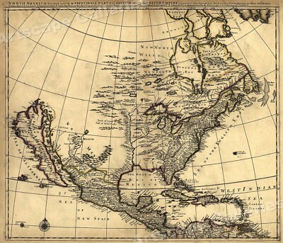
$5.95 Shipping Condition: New Location: Las Vegas, United States North America 1685 Size: 24" x 28" 61 cm x 86 cm) x Also Available in from our eBay Store This is a great Classic Map originally Published circa ... more1685. This Map shows what was known of America(North America) in1685. The wording reads: North America divided into its III principall parts. Features include: New North Wales" Canada) Bay of Mexico" Gulf of Mexico) Sea of the English Empire" Atlantic Ocean) West Indian Sea" Caribbean) Sea of California" Sea of New Spain" Pacific Ocean) New Mexico" Western United States) and"Tract of Land full of Wild Bulls" Great Plains) This poster. Which evokes the vivid images of a simpler time, is a custom reproduction printed on 68lb Heavyweight Enhanced Matte Art Paper. This Historic Art Print is suitable for framing. Mounting or direct display on any wall! 000 Artscape Galleries/ Posters Past More Prints and Posters Available from our eBay Store! Shipping price includes delivery confirmation. We combine shipping for multiple purchases- add $1.00 for each additional poster. All posters are professionally packaged to ensure that they arrive safely and undamaged: Your poster is first rolled and inserted into a plastic sleeve before being placed into a Heavy-Duty mailing tube for delivery. We stand behind the quality of every poster. If you are not satisfied with your purchase. Please contact us within 30 days to arrange for either an exchange or a full refund. gsrx_vers_468(GS 6.4(468)
Buy It Now
$4.99 Shipping Location: Fairview, United States A copy of the original title page with the date is included for authenticity. It is not mounted nor matted, being sold as a single sheet as seen in the ... moremain pic. Condition: The map is in Good condition for its age with overall tonal ageing, blank on the reverse, printed on strong cotton based paper.
Buy It Now
$5.00 Shipping Location: Canada DATE OF ISSUE: Ca. 1935.
Buy It Now
$4.00 Shipping Location: United States An amazing and detailed period map. The map is very detailed and nicely printed on thick paper with no printing on reverse. Gorgeous period color lithographed ... moremap. This is an antique 1899 map and not a reprint or reproduction.
Buy It Now
$6.95 Shipping Location: Dover, United States Issued 1854-62, London & Edinburgh by A. Fullarton & Co. Map engraved by Swanston. Original center fold as issued.
Buy It Now
$11.85 Shipping Location: Dover, United States Issued 1860, Edinburgh & London by Blackie & Sons. Map consists of three sheets. Mid 19th century lithographed map with original outline hand color. United ... moreStates.
Buy It Now
$17.78 Shipping Location: Glenbrook, Australia North Central United States.
Buy It Now
$6.95 Shipping Location: Dover, United States Issued 1885, Glogau by C. Flemming. Uncommon and very detailed 19th century German color lithographed map with original outline hand color. Dictionary ... moreof Mapmakers, vol.

Buy It Now
$5.00 Shipping Location: Canada 1905 ANTIQUE MAP OF NORTH AMERICA/ UNITED STATES/ CANADA CARIBBEAN WEST INDIES This original antique map gives you an opportunity to examine in exquisite ... moredetail a piece of history. If you are interested in the past of this country and its people or have a desire to study where your family may have come from. Then this map gives you a rare look as the area was about 110 years ago. Once matted and framed, this map would make a perfect gift for a family member or friend they'll cherish forever. Origin of the map: Stielers Handatlas" Published in Gotha, Germany by Justus Perthes. Date of issue: 1905 Size: The sheet measures 18 3/4" x 15" 47.5 x 38 cm) S/H: The map will be shipped by Air Mail. The shipping charge is: USA- 7.50 USD. World- 8.50 USD, Canada- 8.50 USD. The price includes the insurance and a strong, cardboard tube with plastic plugs. Attention! There is no additional shipping charge for multiple purchases! Pay me securely with any major credit card through PayPal! Payment methods: US/Canada Buyers: Paypal. International Buyers: Paypal. Click Here. Double your traffic. Get Vendio Gallery- Now FREE!
Buy It Now
$5.00 Shipping Location: Canada DATE OF ISSUE: 1922.
Buy It Now
$33.65 Shipping Condition: Used Location: LONDON, United Kingdom Nebraska Territory extends west to the Rocky Mountains and north to Canada. Oregon & Washington Territories extend from Nebraska to the Pacific. Washington ... moreTerritory had been organized from the half of Oregon Territory north of 46� north and the Columbia River in 1853.
Buy It Now
$11.84 Shipping Location: Lancaster, United States MAPLEWOOD NEW JERSEY. IT LOOKS COMPLETE ON BOTH SIDES. (SEE PICTURES). IT IS 24" X 38".

Buy It Now
$9.96 Shipping Location: GLASGOW, United Kingdom NORTH AMERICA Canada. United States, Mexico- Antique Map 1899 Print Description: NORTH AMERICA Canada. United States, Mexico- Antique Map 1899 Size: The ... moreSize of the print/map not including margins is approximately 18.5x14.5 inches. Cartographer: Provenance: Published at the office of'The Times' Printing House Square, London 1899. Taken From'The Times Atlas' Authenticity: This is a guaranteed genuine antique print. We do not deal in facsimiles or reproductions of any kind. Condition: Very Good; Suitable for framing. We grade all prints individually into four levels- Excellent. Very Good, Good, and Fair. Generally prints in excellent condition are free from foxing, rips,tears or folds. Very Good prints may have some minor foxing or spotting, however this will mainly be confined to the margins. Good and fair may have more general foxing. We try to represent all the images to the best of our ability, and we ask you to check the above scans before purchasing Payment: PayPal is our only accepted method of payment. We accept PayPal payments from buyers all over the world. PayPal is the safest. Easiest and quickest way to make online purchases. If you are purchasing multiple items, please add all the items to your shopping basket before proceeding to the checkout. If you do not already have a PayPal account, simply click on the'Buy It Now' button and follow the eBay checkout instructions. You will then be able to enter your card details in order to pay via PayPal even if you do not already have a PayPal account. Paying via PayPal also ensures that your purchase is fully protected and guaranteed. Returns Policy: If for any reason you are not satisfied with your order we will gladly accept a return for refund or credit. If you wish to return goods you MUST inform us within 14 days of receipt of your order. Please do not return goods without prior consent. All returns must be received in perfect re-saleable condition in order for refunds to be granted. If the item you return does not arrive in perfec
Buy It Now
$4.99 Shipping Location: Fairview, United States The plate marks are embossed in the margin. It is from the 1876 edition of. Stieler's Hand Atlas, published in Gotha by Justus Perthes. The map is not ... moremounted nor matted, being sold as a single sheet with a centerfold as seen in the first pic.

Buy It Now
$14.95 Shipping Location: Netherlands ABOUT US VISIT OUR STORE SALES SPECIALS Antique Map-NORTH EAST AMERICA-UNION-USA-UNITED STATES-NEW YORK-Andree-1904 Description: This large antique map ... moreis taken from; Andrees Allgemeiner Handatlas in 126 Haupt-Und 139 Nebenkarten' Bielefeld; Leipzig: Velhagen& Klasing 1899. Andrees Allgemeiner Handatlas was a major cartographic work published in several German and foreign editions 1881-1937. It was named after Richard Andree(1835-1912) and published by Velhagen& Klasing, Bielefeld and Leipzig, Germany. By using chromolithography, rather than copper plate engraving, but reproducing the maps from zinc plates that were etched in relief(just like letterpress printing) V& K was able to offer detailed maps at a much lower price than competing works, such as the 7th and 8th editions of Stielers Handatlas. Artists and Engravers: Richard Andree(1835- 1912) was. Like his father Karl Andree, a German geographer noted for devoting himself especially to ethnography. His main work, however, is his Allgemeiner Handatlas(Leipzig, first edition 1881, final edition 1937) one of the most comprehensive world atlases of all times. The early editions of the Times Atlas of the World(1895-1900) are based on this atlas, as was Cassell's Universal Atlas. Subject: Map: Nordoststaaten der Nordamerikanischen Union' Map of the North Eastern States of the American Union. With an inset map New York. Condition: Excellent; General age related toning and slight soiling; Please study scan carefully. Size(in cm) The overall size is ca. 56 x 44 cm. The image size is ca. 51 x 40 cm. Size(in inch) The overall size is ca. 22 x 17.3 inch. The image size is ca. 20.1 x 15.7 inch. Medium: Colour lithograph on a vellin type paper. Rear blank. Print originates from atlas. 100% authentic. Location: B37-37 ThePrintsCollector Peter Cornelissen. Margo van Latum- van Dongen, Frank van Latum Zeeland- The Netherlands Phone: +31 654 21 23 78 Worldwide free shipping on all orders. We ship within one business day upon receipt of payment. We sh
Buy It Now
$6.95 Shipping Location: Dover, United States Near San Francisco is GOLD marking where it had then recently been discovered. Fine mid-19th century folio sheet color lithographed map. Original fold ... moreline as issued.
Free Shipping Location: Schertz, United States This Map was removed from an 1855 HARPER'S GAZETTEER and is in good acceptable condition. The map is not " new " or in " new " condition, it was printed ... morein 1855. The map is not dated. Study the photos carefully, this is the actual map you will receive.
Buy It Now
$5.00 Shipping Location: Canada DATE OF ISSUE: 1903.
Buy It Now
$4.99 Shipping Location: Fairview, United States It is by Felix Ansart, from his. Atlas Historique et Geographique Ancien Et Moderne, a copy of the title page is included. The title of the atlas and ... moreF. Ansart appear in the upper margin. Beautiful Color!
Buy It Now
$14.00 Shipping Location: Atlanta, United States No Sandwich Islands is shown. Texas is identified only as CHOCKTAWS.". Then a "ROCK MOUNTAIN" is shown north of where Texas would be. Minor wear and staining ... moreis consistent with age and use but overall displays nicely.
Buy It Now
$9.97 Shipping Condition: Unspecified Location: LONDON, United Kingdom PROVENANCE: "The Handy Royal Atlas of Modern Geography"; by the late Alexander Keith Johnston, with additions and corrections by G.H. Johnston, Published ... moreby W. & A.K. Johnston, Limited, Edinburgh and London.
Buy It Now
$3.75 Shipping Location: United States Superb, very fine and rare antique 1885 handcolored map, printed on thick paper, the gorgeous delicate handcoloring is period to the print, nice outside ... moreornate border. Nice outside ornate border as well This is from the very rare 1885 Lubrecht's Pictorial & Comprehensive Atlas of the World.
Buy It Now
$5.95 Shipping Location: Dover, United States Issued 1924, Edinburgh by W. & A.K. Johnston. Early 20th century color lithographed map. Nice large size.
Free Shipping Location: Schertz, United States This authentic atlas map from 1892 measuring 14x21 inches. Created by cartographer George Cram and published during the late 19th century, this antique ... moreoriginal is a unique piece of history. The map is not *new* or in *new* condition, it was printed in 1892. View photo for best description. The map showcases the boundaries, cities, and topography of the region, providing a glimpse into the past. Ideal for collectors of North America maps or antique maps, this piece would make a great addition to any collection. Its format as an atlas map allows for easy referencing and studying of the territory. Free USA shipping and handling are included in the purchase of this item.
Buy It Now
$9.00 Shipping Location: Cambridge, United States Original Print from "Collier's World Atlas " 1935 Hardcover First Edition(est) book. Approx 14 x 11". In good antique condition with typical wear as seen ... morein pics. One edge is raw. Opposite side may or may not have prints or text which may or may not be related to one shown.
Buy It Now
$9.96 Shipping Location: GLASGOW, United Kingdom Provenance: A plate taken from the Comprehensive Atlas & Geography of the World, compiled and engraved from the most authentic sources, under the supervision ... moreof WG Blackie. Published by Blackie and Son 1883.
Free Shipping Location: Old Orchard Beach, United States This Map was removed from a 1878 Atlas and is in good acceptable condition. Including Hundreds of RareCivil War. 140+ years of aging. Study the photos ... morecarefully, this is the actual map you. will receive.
Buy It Now
$33.65 Shipping Condition: Unspecified Location: LONDON, United Kingdom Nebraska Territory extends west to the Rocky Mountains and north to Canada. Oregon & Washington Territories extend from Nebraska to the Pacific. Washington ... moreTerritory had been organized from the half of Oregon Territory north of 46� north and the Columbia River in 1853.

Buy It Now
$18.95 Shipping Location: YORK, United Kingdom North America United States Canada Mexico Cuba 1882 antique color lithograph map Noord-Amerika(North America) Issued 1882. Amsterdam by G.L. Funke Fine ... moreoriginal antique color lithograph map. Printed in the late 19th century, on quality paper which retains its inherent structural flexibility and soundness. In near VG or better condition. Light minor age wear, some scattered foxing but overall very presentable and attractive[note: we grade very conservatively and always seek to disclose any noteworthy flaws] The printed area remains visually pleasing. A nice impression of an interesting antique map which will look nice when displayed. Sheet measures c. 71/4" W x 9 1/4" H. Printed area measures c. 6" W x 7 7/8" H. Original fold line as issued. 35238] Any defects along the sheet edges and in the margins may be seen in the photos. note: All old sheets of printed paper possibly have short edge splits. Each sheet has existed for a very long time and has probably been handled repeatedly in the course of it's existence. It has a history unique to it as an object. Most of the time any edge splits are short. Minor, insignificant and have been closed- either long ago or more recently with small pieces of archival tape. Most often these splits are trivial and easy to overlook visually. Basically, they would not significantly affect the piece adversely. The item is offered as seen. Please look carefully and make your decision knowing this antique image is nice. But it is not in perfect"like new" condition. However, with whatever flaws it possesses, it remains entirely worthy of ownership and inclusion in any related collection. We feel it will prove very pleasing to its new owner. We stand behind everything we sell. Everything we offer is guaranteed to be an authentic original antique item as described. We do not sell modern reproductions. Please visit our. We happily accept PayPal! WE OFFER FLAT RATE SHIPPING WORLD WI
Buy It Now
$3.50 Shipping Location: Winter Springs, United States On reverse of the map is very detailed period text, and historical images related to these areas. The size of the map is 14.5" by 20". FREE scheduling, ... moresupersized images.
Buy It Now
$4.99 Shipping Location: Fairview, United States It is from Cortambert's. Condition: The map is in Good condition, blank on the reverse with a centerfold as issued. Pics are of the actual map. An Original ... moreAntique Map: Not a Modern Reproduction.

Buy It Now
$6.17 Shipping Location: NORWICH, United Kingdom Vintage Folding Map Publisher: W& R Chambers. Printed by W& A K Johnson Published- 1889 Area Covered- As Per Title Description- Paper map in colour. ... moreCondition- Rough on one edge. Map itself in Vg condition. Centre fold. Size- 8.5" x 10.75" The outer border adding around an inch to each side. Ex Chambers's Encyclopaedia. 1889- One of a number of similar Items I am selling. Postage combined when taking more than one item where possible. If Purchasing Multiple items please await an invoice BEFORE paying. Heavy items may not be able to be sent to PO Boxes overseas. Contact me for more details- Overseas Bidders* No cheques please unless drawn on a UK bank. Overseas transactions to be paid with Paypal. NO Foreign Currency, thanks*All Bidders* Please note that items are sent to the address as stated on your invoice unless I am imformed otherwise in A SEPARATE EMAIL VIA EBAY. I reserve the right to charge an additional fee for higher value items to cover the cost of a'signed for' service. Postage is combined when more than one item is purchased where possible. MY GRADINGS New: A new book. Never used. Fine(F) Should have no flaws, a perfect copy of a used book. Mint: Another term for Fine. As New(AN) Although a used book. It should appear unread with no flaws, just as when it was sold new. Near Fine(NF) May show a small flaw. Such as shelf wear, but nearly perfect and unread. Very Good(VG) The broadest category for used books. This describes any average used book. May have small flaws, and has probably been read, but should appear overall clean and attractive. Good(G) Will probably have significant wear or damage. Although is still intact. Suitable for reading, but not necessarily a good gift copy. The old saying in bookselling is"good ain't good. Fair: Another term for Poor or Reading Copy: Heavily worn or damaged. A poor book will be readable but not attractive. May have the odd page missing, but this will be noted on the relativ
Buy It Now
$4.99 Shipping Location: Fairview, United States It is by Henry Tunison (1855-1915) published inTunison's Peerless Universal Atlas of the World, Jacksonville, Illinois 1886, a copy of the title page ... moreis included for authenticity. It is from one of the rarer early editions of the Peerless Atlas, in which he used very strong and vibrant colors, especially the pinkish reds that have a fluorescent quality.
$25.00 Shipping Location: Perugia, Italy The map covers part of North and South Carolina from Ashe County in North Carolina to the Atlantic Ocean. It was engraved by John Walker of J. and C. ... moreWalker. Date: 1833 ( dated ). The admirable goal of the Society was to distribute useful information via a series of publications to the English working and middle classes.
Buy It Now
$11.85 Shipping Location: Dover, United States Uncommon early 20th century coastal survey with lovely hand color. Map depicts depth soundings. Chart of Chicago Harbor: Showing Yacht Anchorage Club ... moreHouses and Course.
Buy It Now
$17.05 Shipping Location: SALISBURY, United Kingdom This is in nice used condition !
|