Buy It Now
$10.06 Shipping Condition: Unspecified Location: LONDON, United Kingdom PROVENANCE: "The Victoria Regina Atlas"; Published by W & A.K. Johnston, Ltd, Edinburgh & London: 2nd Edition. Antique colour map, 1906. DATE PRINTED: ... more1906. CONDITION: Good; suitable for framing.
Buy It Now
$18.81 Shipping Location: YORK, United Kingdom 1912 ANTIQUE MAP OF ANCIENT MACEDONIA/ GREECE/ THRACIA DACIA BULGARIA TURKEY This original antique map gives you an opportunity to examine in exquisite ... moredetail a piece of history. If you are interested in the past of this country and its people or have a desire to study where your family may have come from. Then this map gives you a rare look as the area was about 100 years ago. Once matted and framed, this map would make a perfect gift for a family member or friend they'll cherish forever. Origin of the map: Philips' Comprehensive Atlas" edited by George Philip and Son. Ltd. Liverpool, England. Date of issue: 1912 Size: The sheet measures 13 1/4" x 10 1/2" 34 x 26 cm) SOME STAINS. S/H: The map will be shipped by Air Mail. The shipping charge is: USA/Canada- 3.50 USD(Letter) World- 8.50 USD(Small Packet) The price includes a strong. Secure envelope/ or a tube with plastic plugs. Attention! There is no additional shipping charge for multiple purchases! Pay me securely with any major credit card through PayPal! Payment methods: US/Canada Buyers: Paypal. International Buyers: Paypal. Click Here. Double your traffic. Get Vendio Gallery- Now FREE!
Buy It Now
$6.95 Shipping Location: Dover, United States Issued 1801, Edinburg by Oliver & Boyd. Original center fold as issued. Scarce early 19th century engraved map with original hand color.
Buy It Now
$6.95 Shipping Location: Dover, United States Lovely 19th century engraved and lithographed map with original hand color. Issued c. 1850-54, Philadelphia by Coweperthwait for S.A. Mitchell.
Buy It Now
$6.00 Shipping Location: Greenacres, United States
Buy It Now
$6.95 Shipping Location: Dover, United States Issued c. 1870, Paris by Fosset. Map by Vuillemin. Nice late 19th century engraved map with original hand color. Piano key border.

Buy It Now
$10.06 Shipping Condition: Unspecified Location: LONDON, United Kingdom Turkey in Europe and the Balkans; Inset map of Moldavia; The Dardanelles Colour antique map. Scale 1:2.150,000, 1907 Title of map: Turkey in Europe and ... morethe Balkans; Inset map of Moldavia; The Dardanelles' The image below shows an enlarged cross section from the centre of the map to show the level of printed detail. This map is folding hence the centrefold line may show on the image below: DATE PRINTED: 1907 IMAGE SIZE: Approx 37.0 x 50.5cm. 14.5 x 20 inches(Large) Please note that this is a folding map. ARTIST/CARTOGRAPHER/ENGRAVER: Unsigned PROVENANCE: The Harmsworth Atlas and Gazetteer" Published at Carmelite House, London. Please note that virtually all antique and vintage maps and prints have been extracted from books, atlases or newspapers. TYPE: Colour antique map. Scale 1:2.150,000 VERSO: There are images and/or text printed on the reverse side of the picture. In some cases this may be visible on the picture itself(please check the scan prior to your purchase) or around the margin of the picture CONDITION: Good; suitable for framing. Please check the scan for any blemishes prior to making your purchase. Virtually all antiquarian maps and prints are subject to some normal aging due to use and time which is not obtrusive unless otherwise stated. I offer a no questions asked return policy- see below. AUTHENTICITY: This is an authentic historic print. Published at the date stated above. I do not offer reproductions. It is not a modern copy. The term'original' when applied to a print means that it was printed at the first or original date of publication; it does not imply that the item is unique. Print' means any image created by applying an inked block to paper or card under pressure by any method including wood engraving, steel engraving, copperplate, wood cut and lithography. REMARKS: FRANCE: Gravures et Cartes anciennes. DEUTSCHLAND: Alte Lankarten und Stadt ansichten. ITALIA: Stampe& Mappe antiche. ESPAÑA: Mapas antiquos y impresiones antiguas. E and OE. Force Majeure. English
Buy It Now
Free Shipping Location: Silverton, United States LIST AT TOP LEFT WITH SCALE BELOW TITLE. DATE-1898 NOT ON MAP. FAIR-GOOD CONDITION, MINOR DISCOLORATION, MAP ON VERSO.
Buy It Now
Free Shipping Location: Augusta, United States "An Authentic Original Map Not A Reproduction".
Buy It Now
$7.00 Shipping Location: Jacksonville, United States The page is approx 21" x 26". Exceedingly nice map of a very high quality.
Buy It Now
Free Shipping Location: Riverside, United States "The Erzerum Campaign". World War I - Original Sheet Map on Vellum. From the book: "History of the Great War " by John Buchan printed in1923.
Buy It Now
Free Shipping Location: Sayville, United States Shows highlands, lowlands, plains, mountains, lakes and rivers.
Buy It Now
$10.00 Shipping Location: Mexico, United States
Buy It Now
$23.48 Shipping Location: GLASGOW, United Kingdom The Citizen’s AtlasCopyright John Bartholomew & Co.
Buy It Now
$6.95 Shipping Location: Dover, United States Lovely 19th century engraved and lithographed map with original hand color. Issued c. 1850-54, Philadelphia by Coweperthwait for S.A. Mitchell.
Buy It Now
$11.95 Shipping Location: Swampscott, United States
Buy It Now
$11.95 Shipping Location: ILKLEY, United Kingdom It has bright, original, outline hand colour. Provenance: 'Handy Royal Atlas of Modern Geography exhibiting the present condition of geographical discovery ... moreand research in the several Countries, Empires, and States of the World', W. & A.K. Johnston, Edinburgh and London, 1896.
Buy It Now
$4.99 Shipping Location: Fairview, United States It is by Hermann Moll, published in W. Stukeley'sGeographia Classica. A copy of the title page is included, although it is not dated, the book is typically ... moredated to 1732. The title page does list "Hermanno Moll, Geograph.".
Buy It Now
$6.95 Shipping Location: Dover, United States Issued 1860, Glasgow by Blackie & Son. Engraved by J.W. Lowry. Original center fold as issued. Fine large mid 19th century engraved map with original ... moreoutline hand color.
Buy It Now
$6.95 Shipping Location: Dover, United States Issued 1850, Philadelphia by Cowperthwait for S.A. Mitchell. Lovely 19th century engraved and lithographed map with original hand color. There are different ... morevariant versions of this map of potential interest to a collector.
Buy It Now
$3.25 Shipping Location: Winter Springs, United States The map is in very nice condition. The size of the map is 8" by 9.5". FREE scheduling, supersized images.

Buy It Now
$9.99 Shipping Location: Ivanhoe, Australia Helpful Links: Company Details- About ME View seller's other items Cartographer's Profile Ask Seller a q uestion Return Policy We have over 2.000 ... moreitems for sale on our Ebay stores site. Please click here to enter the stores and use the search engine to the left to search specifically for maps. Prints, Atlases on the Classical Images Stores. Thank you Turkey in Europe. Greece&c. click image to enlarge This large double page original antique lithograph map of Turkey in Europe was published by John Bartholomew in the 1890 edition of the Citizens Atlas. Ref: M&B; Tooley) Please note all items auctioned are genuine. We do not sell reproductions. A Certificate of Authenticity(COA) can be issued on request. Condition Report General Description: Paper thickness and quality: Heavy& stable Paper color: White Age of map color: Original Colors used: Yellow. Blue, pink General color appearance: Authentic Paper size: 18 1/2i n x 14i n( 470 mm x 360m m) P late size: 18 1/2i n x 14i n( 470 mm x 360m m) Margins: Min 1/2 in( 12m m) Imperfections: Margins: None Plate area: None Verso: None Overall Quality(in Bold) Perfect/ Fine/Very Good/Good/Fair/Poor Payment Methods Visa MasterCard Bankcard* PayPal Direct Bank Transfers& AUS$ Bank Drafts Please contact me to discuss other forms of payment Please also contact me before the end of the auction if you would like to discuss payment by installments over an agreed period Australian buyers please add 10% GST* Please email your CC# Expiry Date, full name on card& shipping address in two separate emails or alternatively you can fax or phone to the numbers below. Shipping Worldwide Australia Air Mail Courier1 Courier2* Express Insurance $ 10.00 US, $ 30.00 US, $12.00 US 2.75% min $6.00 US, $ 6.00 US, 2.75% min $4.00 US, Courier#2: Available for all items 11in x 8 1/2in(280mm x 215mm) or smaller flat or folded along original folds. Airmail shipping from Australia to Europe or the US takes approx. 5-7 days. EMS courier will take 3-5 days. The
Buy It Now
$11.95 Shipping Location: SHREWSBURY, United Kingdom By William Guthrie.
Buy It Now
$7.00 Shipping Location: New Paltz, United States This beautiful map was taken from an 1894 book entitled The New Family Atlas published by Hilton, Hughes & Co. (Successors to A.T. Stewart & Co). MAP ... moreOF ASIA. Single Page You decide which side to display.
Buy It Now
$10.06 Shipping Location: POOLE, United Kingdom TURKEY IN EUROPE ACCORDING TO THE NEWEST OBSERVATIONS BY HERMAN MOLL c1711 GREECE AND THE BALKANS A GENUINE ORIGINAL COPPER ENGRAVED MAP PRODUCED FOR ... more"ATLAS GEOGRAPHUS" PRINTED BY JOHN NUTT, LONDON 1711 THIS ENGRAVED MAP IS IN GOOD CONDITION WITH A CLEAR IMPRESSION AND HAND COLOURING THERE IS A FEINT FOLD CREASE AS PUBLISHED. THE LEFT MARGIN IS NARROW THE MAP MEASURES APPROX 10 x 7 ins (25 x 17.5 cms) PLUS MARGINS. THIS IS A GENUINE ANTIQUE MAP OVER 290 YEARS OLD HERMAN MOLL (1654?-1732) WAS AN IMPORTANT ENGRAVER, CARTOGRAPHER, MAPSELLER AND GLOBEMAKER WHO HAS BEEN DESCRIBED AS "GREAT BRITAIN'S MOST CELEBRATED GEOGRAPHER AND MAPMAKER OF THE FIRST HALF OF THE EIGHTEENTH CENTURY".
Buy It Now
$6.23 Shipping Location: TORRINGTON, United Kingdom PRINT IS ONE OF THE PLATES FROM BOOK AND IS A DOUBLE PAGE FOLD OUT PRINT, CLEAR TO REVERSE WITH NO TEXT ANDREADY FOR MOUNTING AND FRAMING. PRINT HAS BEEN ... moreCAREFULLY REMOVED FROM BOOK, AS THIS IS A DOUBLE PAGE MAP THERE IS A FOLDING CREASE TO CENTRE.
Buy It Now
$4.99 Shipping Location: Fairview, United States It is from Houze's. Atlas Universel Historique et Geographique, published in Paris in 1849. A copy of the Atlas title page is included for authenticity. ... moreIt is an antique historical map. Condition: It is in Good to Very Good condition for its age printed on heavy paper, blank on the reverse with original hand color outlining as issued.
Buy It Now
$15.09 Shipping Location: BOURNEMOUTH, United Kingdom PUBLISHED BY - WILLIAM & ROBERT CHAMBERS, LIMITED, LONDON & EDINBURGH. PUBLISHING DATE- 1901. POLITICAL MAP. MAP SIZE - 215mm x 270mm.
Buy It Now
$5.00 Shipping Location: Canada DATE OF ISSUE: 1900. ORIGIN OF THE MAP: "Brockhaus Konversations-Lexikon", 14th Edition, published by Bibliographisches Institut in Leipzig, Germany.
Buy It Now
$10.06 Shipping Condition: Unspecified Location: LONDON, United Kingdom Antique atlas map with original hand colouring / coloring, 1856. DATE PRINTED: 1856. PROVENANCE: "General Atlas of the World", by Sidney Hall, William ... moreHughes FRGS &c. new edition, Edinburgh; Adam & Charles Black, North Bridge.
Buy It Now
$12.00 Shipping Location: Seminole, United States Offered For Sale is a Rare 1886 Hand Colored Engraved Map of Turkey, Persia, Palestine, Afghanistan & Other Middle Eastern Countries - From "Rand McNalley ... moreSystem of Geography" - matted and under shrink wrap - please excuse the glare in the photos from the shrink wrap - in excellent condition, with vibrant colors - overall size with the mat is about 12 1/2" x 14 1/2".
Buy It Now
$11.95 Shipping Location: SHREWSBURY, United Kingdom GREECE, SERBIA, BULGARIA, TURKEY, ALBANIA, ROMANIA, Teesdale antique map 1841. Published by Henry Teesdale London 1841 in "A New General Atlas of the ... moreWorld". We do not deal in reproductions, facsimiles or modern copies of any kind.

Buy It Now
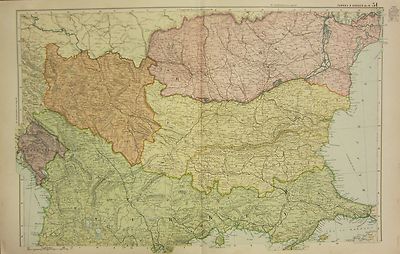
$32.00 Shipping Location: Latvia ★ ★ ★ ★ ★ 5-star service for you ★ ★ ★ ★ ★ ★ Worldwide shipping within 1 business day of payment ★ Professional Packaging ★ Tracking registered air mail ... more★ Possibility Express Mail Service ★ Combined Shipping Discount or Free shipping After you have won the item. You have 4 days to pay( if no bid on other item) or PLEASE LET ME KNOW POSSIBLE TERM OF PAYMENT. European Dominions of the Ottomans or Turkey in Europe WYLD James Place Published: London Publisher: James Wyld Date Published: early nineteenth century сirca 1830 Engraving with original hand coloring. sheet size: ~ 79x58.5 cm. 31.1" x 23" Good Heavy(Thick) Paper folded 2x condition(in Bold) Perfect/Fine/Very Good/Good/Fair/Poor Large detailed map of the Region bounded by the Mediterreanean. Southern Russia, Crimea, Bulgaria, Moldavia, the Gulf of Venice and Asia Minor. The map shows the Ottoman Empire, circa 1720 and includes and ornate decorative cartouche. James Wyld(1812–1887) was a British mapmaker. Publisher, and the Geographer to Her Majesty Queen Victoria and Prince Albert. Wyld was perhaps best known for his Monster Globe, a giant globe 60 feet 4 inches in diameter. Patrons would actually enter the giant sphere and walk up several flight of stairs as they observed the concave globe which surrounded them. The Monster Globe sat in Leicester Square from 1851-1862. Wyld was recognized as a very prolific publisher of contemporary maps and guides, and his maps, which depicted a wide-range of regions, were highly regarded.Wyld maintained the high standard of graphic and factual excellence that had been established by his predecessor and his maps are among the finest published in the early nineteenth century. Map will be shipped in strong tube g reat value for collectors& all interior decorators: hotels. Bars, offices, public buildings, restaurants, b&b, homes. The images should be considered as part of the item description. Default delivery is registered mail. Parcel Information Online- enter tracking number supremeauctiononlinesoftware.au
Buy It Now
$4.99 Shipping Location: Fairview, United States Atlas de toutes les parties connues du globe terrestre, published around 1780, afacsimile copy of the title page is included, which is undated. Bonne ... moreworked under Jacques Nicolas Bellin and succeeded him as the Royal Hydrographer of the King of France in 1773.
Buy It Now
$6.00 Shipping Location: Williamsport, United States 18th century original. Historical reports may be beautiful or ugly, but they are always informative. If you find any to be offensive, we agree! Hopefully ... morethis is an indication we are moving in the right direction.
Buy It Now
$10.06 Shipping Location: BATH, United Kingdom He published a range of atlases, both contemporary and historical. Blank on the reverse. Map area is in good condition for age, engravings are clear.
Buy It Now
$6.00 Shipping Location: North Wales, United States 1898 RARE ANTIQUE CHAMBERS ATLAS MAP-TURKEY, GREECE, ROMANIA, SERVIA, MONTENEGRO ORIGINAL RAILROAD ATLAS MAP PLEASE SEE PHOTOS AS PART OF THE DESCRIPTION ... moreCONDITION: MAP IS IN GOOD CONDITION. APPROXIMATELY 7" X 9" SHIPPING: U.S. FIRST CLASS RATE - $7.00 - ANY ITEM WHICH SELLS FOR OVER $100 WILL REQUIRE INSURANCE WE COMBINE SHIPPING FOR MULTIPLE WINS. THANK YOU FOR YOUR INTEREST IN OUR AUCTIONS!.
Buy It Now
$6.00 Shipping Location: North Wales, United States 1872 ANTIQUE MCNALLY MAP OF AUSTRIA, ITALY, TURKEY, GREECE-EXCELLENT DETAIL ORIGINAL ANTIQUE ATLAS MAP PLEASE SEE PHOTOS AS PART OF THE DESCRIPTION CONDITION: ... moreMAP IS IN GOOD CONDITION SIZE: APPROXIMATELY 10" X 12" SHIPPING: U.S. FIRST CLASS RATE - $7.00. CANADA - $20.00. WORLDWIDE - $25.00 ANY ITEM WHICH SELLS FOR OVER $100 WILL REQUIRE INSURANCE. WE COMBINE SHIPPING FOR MULTIPLE WINS. THANK YOU FOR YOUR INTEREST IN OUR AUCTIONS!.
Buy It Now
$4.99 Shipping Location: Fairview, United States It is by Delamarche from his. Atlas de Geographie Physique, Politique, et Historique" published in Paris with a date of 1864 on the map. Condition: It ... moreis in Good to Very Good condition for its age, basically as seen in the pics, blank on the reverse, with original hand coloring and a centerfold as issued, the paper is still very good and flexible, not brittle.
Buy It Now
$4.99 Shipping Location: Fairview, United States It is from Monin & Fremin's. Atlas Universel, published in Paris by Logerot, c. 1835, a facsimile copy of the title page is included. Condition: The map ... moreis in Very Good condition for its age, blank on the reverse, printed a bright page, with original hand outlining as issued, basically as seen in the pic.
Buy It Now
$4.95 Shipping Location: Dover, United States Issued 1835, Boston by Bradford for his "Atlas of Universal Geography".
Buy It Now
$14.00 Shipping Location: Beograd 6, Serbia (Turkiye – Kibris) – In the Turkish language. Printed in Istanbul in 1971. Nautical Chart Cyprus. Country of manufacture: Turkey. Year: 1971. You just ... moreneed to make a request for a separate invoice.
Buy It Now
$3.50 Shipping Location: Winter Springs, United States This dates the map nicely. The gorgeous handcoloring is period to the map, this is before color printing. Printed on thick paper, with no printing on ... morereverse. The map The size of the map is 12" by 18.5.
Buy It Now
$4.99 Shipping Location: Fairview, United States It is by Hermann Moll, published in W. Stukeley'sGeographia Classica. A copy of the title page is included, although it is not dated, the book is typically ... moredated to 1732. The title page does list "Hermanno Moll, Geograph.".
Buy It Now
$6.54 Shipping Location: MARLOW, United Kingdom DATE PRINTED : 1838 (dated on print). He also was interested in astronomy and developed a model of the moon surface. He died in 1806 in Hull. An attractive ... moremap with original colour. VERSO : There is nothing printed on the reverse side, which is blank.
Buy It Now
Free Shipping Location: Sayville, United States See photo's.
Buy It Now
$30.00 Shipping Location: Paris VI, France In 1716 Homann published his "Grosser Atlas ueber die ganze Welt" (Grand Atlas of all the World). Homann died in Nuremberg. Large detailed antique copper ... moreengraved map of the Turkish Empire, by Homann Heirs.
Buy It Now
$13.84 Shipping Location: BRIDGEND, United Kingdom Original map from disbound 1903 encyclopaedia. Map has centrefold.
Buy It Now
$10.06 Shipping Condition: Unspecified Location: LONDON, United Kingdom Antique colour map, 1873. DATE PRINTED: 1873. AUTHENTICITY: This is an authentic historic print, published at the date stated above. It is not a modern ... morecopy.
Buy It Now
$3.75 Shipping Location: United States The superb handcoloring is period to the map, this is before color printing. The map is in very fine condition. The size of the map is 10" by 12". FREE ... morescheduling, supersized images.
Buy It Now
$3.38 Shipping Location: Brooklyn, United States The Parthenon & Acropolis. The Academy and University at Athens. All the item are Blank on the reverse. Grecian art in Color with Tissue overlay.

Buy It Now
$7.00 Shipping Location: North Wales, United States 1866 McNally’s Hand-Colored System of Geography MAP No. 24 of AUSTRIA/ ITALY/ TURKEY/ GREECE and surrounding areas Rare antique map page from the 1866 ... moreFrancis McNally Atlas. Drawn by J. Wells. N.Y. Engraved by George E. Sherman. N.Y. Detailed map of Italy. Turkey, Greece and Austria, with portions of adjacent countries. Includes provinces, divisions, cities, towns, bodies of water, mountains, islands, topography, latitude and longitude lines, nautical miles and more. CONDITION: See condition notes above SIZE: APPROXIMATELY 9-1/2" X 12" We examine our items carefully and describe them as accurately as possible. Bear in mind that this item is used(to say the least! But that it has been carefully preserved. Please read details carefully before bidding and feel free to email us through eBay with any questions or requests. PAYMENT: Auction payment for this item is due within 5 days of purchase- and we love to mention fast payment in our feedback! Fixed Price(BUY IT NOW) payments are due upon purchase. Barring extreme weather. We will send your item within 1 business day of receipt of payment. RETURNS: We are not a store and operate on a small scale. With low margins; therefore we would hope that our buyers return items only when there is a genuine problem with the item. Return shipping is the responsibility of the buyer. Refunds will be made only if the item is received back in the same condition as sent. There will be a 10% restocking fee for returns. Plus our original shipping cost, unless otherwise stated in the listing and unless there has been an error in the listing description. Please read listings. Details and measurements carefully before bidding. Thank you! NOTE: Free shipping to U.S. only ~ Smoke-free environment ~ Feel free to contact us through eBay with questions… and please check out our other listings. In many and varied categories, including clothing, shoes and accessories, sporting goods and athletic apparel, antiques, collectibles, books, music, home decor, and much more, with more
Buy It Now
$6.00 Shipping Location: Blue Bell, United States THIS MAP IS IN GOOD CONDITION AND PUBLISHED BY AUGUSTUS MITCHELL. CONDITION: MAP IS IN GOOD. OVER 150 YEARS OLD! Over 100,000,000 served. MULTIPLE WINS.
Buy It Now
$18.87 Shipping Location: CHICHESTER, United Kingdom Publication : Kleine Weltchronik. Schonsperger, Augsburg, 1496. 1st edition incunabulum, with German text. Search 'Schonsperger' or 'Schedel' for other ... moreexamples from this publication. Date : 1496.
Buy It Now
$5.00 Shipping Location: Canada DATE OF ISSUE: 1908.
Buy It Now
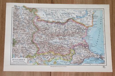
$5.00 Shipping Location: Canada Home ~ Affiliations ~ Discounts ~ FAQs ~ Grading and Certification ~ Premium Shipping ~ About Us VINTAGE ART& ADVERTISING CURATED COLLECTIONS 1924 ... morePrint Map Ottoman Empire Turkey Armenia Rumania Bulgaria Persia XEAA4 Details Year: 1924 Type: Relief Line-block Map Grade: Near Mint/ Very Fine Authentication: Dual Certificates Image: Black/ White Approximate Size(inches) 10.5 x 8 Approximate Size(cm) 27 x 20 Description and Condition This is an original 1924 black and white relief line-block map that marks the greatest extent of territory that the Ottoman Empire acquired during the period of 1481-1683 and the area of the country of Turkey in 1920. CONDITION This 87+ year old Item is rated Near Mint/ Very Fine. Light aging throughout. No creases. Original portfolio crease. No surface rub. No tears. No water damage. To find other items from this specific collection in our eBay store. Please. Keywords specific to this image: Middle East. Egypt, Cairo, Port Said, Damascus, Jerusalem, Constantinople, Tabriz, Tiflis, Kutais, Kars, Batum, Astrakhan, Krasnovodsk, Baku, Teheran, Stacropol, Rostov, Yeisk, Azov, Crimea, Sevastopol, Kherson, Taurida, Ekaterinoslav, Kharkov, Dnierper, Odessa, Podolia, Bessarabia, Danube, Transylvania, Lemberg, Brunn, Prague, Vienna, Munich, Venice, Austria-Hungary, Budapest, Adrianople, Rumelia, Bucharest, Belgrade, Montenegro, Albania, Dalmatia, Trieste, Rome, Malta, Athens, Aegean, Mediterranean, Cyprus, Beirut. XEAA4C24 178727_XEAA4_007 Product Pricing& What We Deliver At times we receive inquiries about our pricing. Especially for vintage advertising or historical halftone prints, and are asked why our prices are consistently higher than some other sellers of similar items. For the first five years of our business, we asked our primary consumer base what they wanted. Our primary consumers- historical societies, historians, archivists, curators, university professors, historical decorators, and collectors, etc. have diverse and specific needs and we've built our business to accom
Buy It Now
$22.95 Shipping Location: Littlestown, United States Up for sale is a rare hand colored Turkey In Europe framed map Overall it is in good antique condition with scuffs on the wood frame and a small hairline ... moretear at the corner of the map which is included in the photos.Please refer to the pictures,what you see in the photos is what you will receive Overall measures 17" tall an 13" wide Please contact me if you have any questions
Buy It Now
$4.99 Shipping Location: Fairview, United States It is fromWarren's Common- School Geography, published in Philadelphia by Cowperthwait & Co., 1882, a copy of the title page is included. An Authentic ... moreAntique Map: Not a Modern Reproduction! Condition: It is in Good to Very Good condition for its age with overall light tonal ageing.
Buy It Now
$9.99 Shipping Location: Ivanhoe, Australia (Ref: M&B; Tooley). He was baptised at St Cuthbert's Church, Edinburgh on 15 October 1808. He lived with his family at Potterrow on the South Side of ... moreEdinburgh. Gall & Inglis. He was living at Myrtle Bank in Trinity, Edinburgh.
Buy It Now
$9.99 Shipping Location: Ivanhoe, Australia Boulton, Samuel. Boulton was a British publisher in the mid to late 19th century. Date: - 1890. This original coloured antique lithograph map was published ... morein the 1890 edition of Boultons Finsbury Atlas.
|