
Buy It Now
$15.00 Shipping Location: Cyprus . ANTIQUE BATTLE PLAN OUDENAERDE OUDENAARDE BELGIUM BATTLE OF OUDENARD RAPIN 1743 Title: Plan of the Battle of Oudenard fought July 11th. 1708. Fine ... moreengraved plan with excellent detail of the fortifications of Oudenaerde Belgium. Full hand coloring and a decorative explanation cartouche complete the map. From Tindal’s Continuation of Rapin’s History of England. Paul de Rapin(25 March 1661– 25 April 1725) Sieur of Thoyras(and therefore styled Thoyras de Rapin) was a French historian writing under English patronage. Engraved by James Basire(1730–1802) Also known as James Basire Sr. 17th-18th Century maps& atlases& prints. ORIGINAL ANTIQUE COPPER PLATE ENGRAVING. HAND COLORED. Engraving is Absolutely Guaranteed authentic original map. A Certificate of Authenticity will be on request forwarded for each individual map or print. Sheet app. 51 x 41 cm. 20.25 x 16 inches. Image app. 48 x 37 cm. 18.75 x 14.25 inches. Condition: Very good. Small skillful marginal repair. Fold as published. All maps and prints are genuine. Authentic, published at the date stated in this listing! For better quality pictures please go to our web site: WWW.MAPANDMAPS.COM I offer a no questions returns policy. All maps and prints are genuine. Authentic, published at the date stated above. Worldwide shipping by signed registered mail or Global Express courier. Shipping: Worldwide shipping by signed registered mail or Global Express courier . Standard Int'l Shipping means registered airmail of Europe. If you want to receive the item quickly. Ask for Expedited Int'l Shipping or a 3 days Shipping by FedEx. between $ 25.95 and $ 38.50) Shipping fee is per combined shipment. Including handling and insurance. Free shipping worldwide if three items or more purchased. . . .
Buy It Now
$11.92 Shipping Location: ILKLEY, United Kingdom An original antique map of the Battlefield of Auerstedt in Germany in 1806. It is titled, 'Plan du Champ de Bataille d'Auerstaedt.'. The map shows the ... morearea, which was contested between the French under Napoleon and forces from Prussia and Saxony, in considerable detail.
Buy It Now
$24.09 Shipping Location: LICHFIELD, United Kingdom BOER WAR ERA MAP/BATTLE PLAN FABER'S PUT 30th JUNE 1900 MAHONS MARCH TO MAFEKING Approx A4 size
Buy It Now
$14.99 Shipping Location: Ivanhoe, Australia The Map Collector magazine was started by Tooley in 1977 when the Map Collector’s Circle ceased publishing. (Ref: M&B; Tooley). Here he continued his ... moreresearch, spending long hours in the Map Room of the British Museum.
Buy It Now
$10.04 Shipping Condition: Unspecified Location: LONDON, United Kingdom 'Plan des Batailles de Smolensk, et de Valutin-Gora'. Title of map:'Plan des Batailles de Smolensk, et de Valutin-Gora'. Antique copperplate map, 1820. ... moreDATE PRINTED: 1820. CONDITION: Good; suitable for framing.
Buy It Now
Free Shipping Location: Netherlands Description: This very rare old antique copperplate engraved print originates from: 'Kleyne en Beknopte Atlas, of Tooneel des Oorlogs in Europa, ...', ... morepublished in Amsterdam by David Weege, 1753. First and only very rare edition. This work is a reissue of an atlas published by Erven J. Ratelband en Compagnie, Amsterdam, 1735, enlarged with 25 maps / views. Include maps and views from earlier sources like Jacob Aertsz. Colom (c. 1635) and Daniel de La Feuille (c. 1706). Ref: Koeman Wee 1. Artists and Engravers: The publisher of this work is David Weege (active Amsterdam 1748-1787).
Buy It Now
$21.25 Shipping Location: Bensalem, United States Plan de la Bataille de Hochkirchen Oct. re 14. Seven Year War 1756–63 / Battle near Hochkirch on October 14, 1758.
Buy It Now
$24.09 Shipping Location: LICHFIELD, United Kingdom 2x BOER WAR ERA MAP/BATTLE PLAN- 1900, The Zand River, Capture Of 13th Lindley Approx A5 size.
Buy It Now
Free Shipping Location: Netherlands Description: This old antique engraved copperplate print originates from 'Histoire des quatre dernieres campagnes du Maréchal de Turenne en 1672-1673-1674 ... moreet 1675, enrichie de cartes et de plan topographiques, dediee et presentee au Roi, par M. Le Chevalier de Beaurain, Geographe de Sa Majeste, & son Pensionnaire.', published in Paris Chez le Chevalier de Beaurain, 1782. This work tells the history and documents the war of the French against the Netherlands and its allies. Ref: Brunet I, 733 - Barbier 7928. Henri de la Tour d'Auvergne-Bouillon (1611-1675), viscount of Turenne, duke of Bouillon, prince of Sedan, generally known as Turenne, was one of the best generals for Louis XIII and Louis XIV.
Buy It Now
$15.00 Shipping Location: Cyprus Title: Plan de la Bataille D’Oudenaerde. Publisher: Jean Dumont Baron de Carlscroon (13 January 1667 – 13 May 1727) was a French publisher. 59 x 48.5 ... morecm. Condition: Historical map in very good condition, hand coloring, no defects.
Buy It Now
$25.09 Shipping Location: ILKLEY, United Kingdom An original antique map of STAFFORDSHIRE(Stafford Countie and Towne) by John Speed. The map was first published in Speed'sTheatre of the Empire in 1611. ... moreThis example is the Bassett & Chiswell edition of 1676.
Buy It Now
$10.04 Shipping Condition: Unspecified Location: LONDON, United Kingdom 'Second Battle of Cassino. Title of map:'Second Battle of Cassino. This map was published in 1973 but it may depict an earlier representation of the area ... moreshown dated 1944 and the mapmaker may have drawn on an earlier original work.
Buy It Now
$18.82 Shipping Location: CHICHESTER, United Kingdom Siege of Colberg (Kolobrzeg, Poland), 1761. Troupen unter comando des Hl. Grafen von Romanzow 1761. Very good. Any folds are as issued. Blank verso. Color: ... morepartially coloured. Technique: copper-plate engraving.
Buy It Now
$22.87 Shipping Location: SHEFFIELD, United Kingdom This is a copy of a map of Glamorganshire by John Speed and was initially printed in the 1600's. There is also a plan of Cardiff and Llandaff on the map. ... moreThe map is beautiful, the colours are vibrant and overall it's in very good condition.
Buy It Now
$3.95 Shipping Location: Clarkston, United States This DVD is part of our Historic Map and Atlas Collection. South Carolina. 0089029 South Carolina. 0122019 Map Of South Carolina. 0346027 Map Of North ... moreAnd South Carolina With Their Indian Frontiers.
Buy It Now
$24.09 Shipping Location: LICHFIELD, United Kingdom BOER WAR ERA MAP/BATTLE PLAN BULLER'S ADVANCE THROUGH NATAL MAY-JUN 1900 TROOPS Vintage map as shown.
Buy It Now
$9.99 Shipping Location: Rosanna, Australia The Battle of Eylau, or Battle of Preussisch-Eylau, was a bloody and strategically-inconclusive battle on 7 and 8 February 1807 between Napoléon's Grande ... moreArmée and the Imperial Russian Army under the command of Levin August von Bennigsen near the town of Preussisch Eylau in East Prussia.
Buy It Now
$6.95 Shipping Location: Dover, United States Kingdom Piedmont Italy c. 1850 lg. topographical war map Mila Brescia Lake Como. Scarce detailed French military topographical map with original hand ... morecolor, dissected and backed on sturdy linen paper long ago.
Buy It Now
$24.09 Shipping Location: LICHFIELD, United Kingdom BOER WAR ERA MAP/BATTLE PLAN- Operations Round Johannesburg. 1900 Approx 15x8 inches
Buy It Now
$24.09 Shipping Location: LICHFIELD, United Kingdom BOER WAR ERA MAP/BATTLE PLAN- Seige Of Kimberley. 1900 Approx 15x13 inches
Buy It Now
$22.11 Shipping Location: SHEFFIELD, United Kingdom This is a copy of a map of the town of Canterbury, England by John Speed and was initially printed in the 1600's. It is double mounted, firstly with black ... morecard and then with thick ivory coloured card which has been cut with a bevelled inside edge.
Buy It Now
$14.99 Shipping Location: Ivanhoe, Australia Tindal\\\'s translation of de Rapins History, was first published in 1727. In 1745 Tindal publishedTindal’s Continuation of Mr. Rapin’s History of England. ... moreNicolas Tindal was the translator and continuer of theHistory of England published by Paul de Rapin (1661-1725) in 1724.
Buy It Now
$10.00 Shipping Location: Cyprus D'après le plan dresse par M. d’Anville pour l’Histoire Romaine de M. Philippe. Fine original antique copper plate engraving with hand coloring. For the ... morecomplete Map and Print collection see our online site.
Buy It Now
$6.95 Shipping Location: Dover, United States Issued c.1840. Map by Keller. La Suisse Par Keller. Detailed and uncommon large mid-19th century engraved map. Mountain height comparison diagram inset ... moreat lower right, environs of Geneva inset lower left.
Buy It Now
$25.63 Shipping Location: SHEFFIELD, United Kingdom This is a copy of a map of Middlesex by John Speed and was initially printed in the 1600's. There is also a small plan of London and of Westminster on ... morethe map. The map is beautiful, the colours are vibrant and overall it's in excellent condition.

Buy It Now
$15.00 Shipping Location: Cyprus . The Battle of Ekeren. June 30, 1703 was a battle of the War of the Spanish Succession. The French surrounded a Dutch force, which barely avoided ... moredestruction. This battle ended hope of a decisive allied victory in the Spanish Netherlands in 1703) Engraving is Absolutely Guaranteed authentic original map. A Certificate of Authenticity will be on request forwarded for each individual map or print. Size: Sheet app. 50 x 39.5 cm. 20.5 x 15.5 inches. Condition: Very good hand colored map. Folds as published. All maps and prints are genuine. Authentic, published at the date stated in this listing! For better quality pictures please go to our web site: WWW.MAPANDMAPS.COM I offer a no questions returns policy. All maps and prints are genuine. Authentic, published at the date stated above. Worldwide shipping by signed registered mail or Global Express courier. Shipping: Worldwide shipping by signed registered mail or Global Express courier . Standard Int'l Shipping means registered airmail of Europe. If you want to receive the item quickly. Ask for Expedited Int'l Shipping or a 3 days Shipping by FedEx. between $ 25.95 and $ 38.50) Shipping fee is per combined shipment. Including handling and insurance. Free shipping worldwide if three items or more purchased. . . .
Buy It Now
$9.99 Shipping Location: Ivanhoe, Australia The Siege of Bouchain (9 August – 12 September 1711), following the Passage of the Lines of Ne Plus Ultra (5 August 1711), was a siege of the War of the ... moreSpanish Succession, and the last major victory of John Churchill, 1st Duke of Marlborough.
Buy It Now
$22.11 Shipping Location: SHEFFIELD, United Kingdom This is a copy of a map of the town of Exeter, England by John Speed and was initially printed in the 1600's. It is double mounted, firstly with green ... morecard and then with thick ivory coloured card which has been cut with a bevelled inside edge.
Buy It Now
$18.82 Shipping Location: CHICHESTER, United Kingdom Siege of Nysa (Neiss), Poland in 1758. Silesia, Schlesien, 7 Years War, Prussia, Preussen. Very good. Any folds are as issued. Blank verso. Color: coloured. ... moreSize (h x w): 16.7 x 26.8 cm. stWorld War, but more commonly the 3.
Buy It Now
$18.82 Shipping Location: CHICHESTER, United Kingdom Siege of Nysa (Neiss), Poland in 1758. Title: Plan de la ville et siege de Neiss par le troupes Austrichiennes comandes par General Harsch. Silesia, Schlesien, ... more7 Years War, Prussia, Preussen. Very good.
Buy It Now
$10.04 Shipping Condition: Unspecified Location: LONDON, United Kingdom Antique colour military map, 1959. DATE PRINTED: 1959. TYPE: Antique colour military map. VERSO: There is another map printed on the reverse side. AUTHENTICITY: ... moreThis is an authentic historic print, published at the date stated above.
Buy It Now
$10.04 Shipping Location: SHEFFIELD, United Kingdom John Speed map which was originally printed in the 1600's. There is also a small plan of the town of Nottingham on the map. This map is printed on good ... morequality paper but as it is from a book it is on 2 seperate pieces of paper.
Buy It Now
$25.63 Shipping Location: SHEFFIELD, United Kingdom This is a copy of a map of Lincolnshire and was initially printed in the 1600's. There is also a small plan of Lincoln on the map and lots of pictures ... moreof various coats of arms. The map is beautiful, the colours are vibrant and overall it's in excellent condition.
Buy It Now
$15.00 Shipping Location: Cyprus Title: Plan et Attaque de la Ville de Landau 1704. Origin: Histoire militaire du Prince Eugene, du Duc de Marlborough, et du Prince d'Orange et de Nassau. ... moreORIGINAL ANTIQUE COPPER PLATE ENGRAVING, HAND COLORED.
Buy It Now
$25.63 Shipping Location: SHEFFIELD, United Kingdom This is a copy of a map of Derbyshire and was initially printed in the 1600's. There is also a small plan of Derby on the map and lots of pictures of ... morevarious coats of arms. The map is beautiful, the colours are vibrant and overall it's in excellent condition.

Buy It Now
$6.00 Shipping Location: Greenacres, United States 1888 Map SPAIN PORTUGAL Lisbon Madrid Barcelona Majorca Handsome original antique color lithographed map of Spain and Portugal. Printed more than 123 ... moreyears ago. The image area measures 32.5 x 49.5 cm[12-3/4" x 19-1/2" And details include railroads, cities, towns, battle fields, submarine telegraph cable lines, and natural features, with attractive coastline shading. Longitude is measured from Greenwich and Washington, and there is a decorative banknote border. The scans below give a closer look: There are inset plans of Lisbon and Madrid. Among the other named places on the map are Barcelona. Gibraltar, Valencia, Malaga, Ibiza, Minorca, Cadiz, Oporto, Salamanca, Granada, Castellon, and many more. Condition: This map is in very good condition. Bright and clean, with a vertical center fold, as issued, and no marks. Rips, or tears. It is an original. Authentic antique map, not a reproduction or modern reprint. And it is fully guaranteed to be genuine. It was compiled and engraved by Rand McNally& Company, Chicago, 1888 and would make a handsome display in your den or office. It would also make a perfect gift, and we'll include our helpful framing tips for your reference, along with a photocopy of the dated title page from the book in which it was published. We are pleased to offer it with our unconditional. Money-back guarantee. SHIPPING: We gladly ship anywhere in the World. And we use sturdy, professional packing materials to assure safe delivery. The shipping charges are as follows: Within the United States. Including Alaska, Hawaii, and APO addresses: $6.00 To Canada or Mexico: $11.59 To all other international destinations: $16.49(These charges reflect recent increases made by the United States Postal Service for international delivery. We will appreciate your prompt payment for this item. If you need more time or have any other questions about making your payment. Or if you may desire any special services, such as overnight delivery or tracking number, please contact us. Florida residents add

Buy It Now
$15.00 Shipping Location: Cyprus Title: Plan of Toulon. With a View of its Road, and the Situationof its Towns, c. For Mr. Tindal's Continuation of Mr. Rapin'sHistory of England. ... moreThe map illustrates troop movements during the Brittan Dutchattack. Natural terrain features, cities and manmade structuressuch as barrages. Engraved by James Basire(1730–1802) Also known as James BasireSr. Engraving is Absolutely Guaranteed authentic original map. A Certificate of Authenticity will be on request forwarded for eachindividual map or print. Condition: Image very good. Folds as published, tiny tear lowerright hand border. All maps and prints are genuine. Authentic, published at the date stated in this listing! We sell Real Antique. No Reproduction, no Copy! THE PERFECT GIFT! For better quality pictures please go to our web site: WWW.MAPANDMAPS.COM I offer a no questions returns policy. All maps and prints are genuine. Authentic, published at the date stated above. Shipping: Worldwide shipping by signed registered mail or Global Express courier. Standard Int'l Shipping means registered airmail of Europe. If you want to receive the item quickly. Ask for Expedited Int'l Shipping or a 3 days Shipping by FedEx. ask for price) Shipping fee is per combined shipment. Including handling and insurance. Free shipping worldwide if three items or more purchased.
Buy It Now
$10.00 Shipping Location: Cyprus A. 1659 obseßum, et 4. deditione captum. The Swedish fleet outgunned by far the Danish-Norwegian fleet, but it did not succeed in breaking the Danish-Norwegian ... moreblockade in the Baltic. Even so, in 1657, extensive preparations for a war of aggression against Sweden were conducted, and on June1, 1657, Denmark once again found itself at war with the Swedes.
Buy It Now
$22.11 Shipping Location: SHEFFIELD, United Kingdom This is a copy of a map of the town of Rochester, England by John Speed and was initially printed in the 1600's. It is double mounted, firstly with black ... morecard and then with thick ivory coloured card which has been cut with a bevelled inside edge.
Buy It Now
$22.58 Shipping Location: LONDON, United Kingdom (1) "Plan der Königl. Attaque der Kayserl. Frederick II of Prussia was desperate to recapture the town of Schweidnitz (Świdnica), when he had previously ... moreannexed and fortified, but lost to the Austrians earlier in 1762.
Buy It Now
$18.82 Shipping Location: CHICHESTER, United Kingdom Siege of Colberg (Kolobrzeg, Poland), 1761. Very good. Any folds are as issued. Blank verso. Color: partially coloured. Technique: copper-plate engraving. ... moreSize (h x w): 17.5 x 25.7 cm. stWorld War, but more commonly the 3.
Buy It Now
$22.82 Shipping Location: SHEFFIELD, United Kingdom This is a copy of a map of Caernarfonshire, Wales by John Speed and was initially printed in the 1600's. There is a also a small plan of Bangor on the ... moremap. The map is beautiful, the colours are vibrant and overall it's in very good condition.
Buy It Now
$18.82 Shipping Location: CHICHESTER, United Kingdom The seige of Colberg (Kolobrzeg, Poland), 1758. Very good. Any folds are as issued. Blank verso. Color: Uncoloured. Technique: copper-plate engraving. ... moreSize (h x w): 13.1 x 21.2 cm. stWorld War, but more commonly the 3.
Buy It Now
$25.55 Shipping Location: SHEFFIELD, United Kingdom This is a copy of a map of Ulster, Ireland by John Speed and was initially printed in the 1600's. There is also a plan of Enis Kelling Fort on the map. ... moreThe map is beautiful, the colours are vibrant and overall it's in excellent condition.
Buy It Now
$28.80 Shipping Location: NORWICH, United Kingdom Engraved map. Sheet size: 46 x 36cm to the inner border. a few light foxing spots, light offsetting from text, light age toning. Plan of Ramillies, showing ... morethe battle fought there during the war of the Spanish Succession (1701-14).
Buy It Now
$27.60 Shipping Location: ILKLEY, United Kingdom An original, copper engraved, antique map of LEICESTERSHIRE (Leicester - both town and citie described.) by John Speed. Verso text provides an index of ... moreplaces in the county and an account of Leicestershire's history and geography.
Buy It Now
$9.99 Shipping Location: Ivanhoe, Australia Tindal\\\'s translation of de Rapins History, was first published in 1727. In 1745 Tindal publishedTindal’s Continuation of Mr. Rapin’s History of England. ... moreNicolas Tindal was the translator and continuer of theHistory of England published by Paul de Rapin (1661-1725) in 1724.
Buy It Now
$11.92 Shipping Location: ILKLEY, United Kingdom An original antique map of the area around Marengo titled, 'Plan Topographique des Environs de Marengo'. It is printed on good quality, hand-laid paper ... moreand has a strong, clear print impression.
Buy It Now
$40.00 Shipping Location: De Fryske Marren - Langweer, Netherlands This print originates from Tindal's Continuation of Rapin's History. Published 1746. Condition: Good. Original folding lines. Few small tears, only slightly ... moreaffecting image.
Buy It Now
$9.99 Shipping Location: Ivanhoe, Australia Ref#: - 22178. Tindal\\\'s translation of de Rapins History, was first published in 1727. In 1745 Tindal publishedTindal’s Continuation of Mr. Rapin’s ... moreHistory of England. Nicolas Tindal was the translator and continuer of theHistory of England published by Paul de Rapin (1661-1725) in 1724.
Buy It Now
$18.82 Shipping Location: CHICHESTER, United Kingdom This has now been expertly repaired. Width (cms) x Height (cms)45.2 x 29.8. TechniqueCopper Engraving.
Buy It Now
$25.63 Shipping Location: SHEFFIELD, United Kingdom This is a copy of a map of Rutland and was initially printed in the 1600's. There is also a small plan of Oakham and Stamford on the map. The map is beautiful, ... morethe colours are vibrant and overall it's in excellent condition.
Buy It Now
$6.95 Shipping Location: Dover, United States Issued 1820, Philadelphia by M. Carey and Son. Map by Aspin. Engraved by Kneass & Young. New Map of France Conforming to the Treaty of Paris, 1815; with ... morethe Netherlands, Switzerland, and Part of Italy, &c. Improved to 1820 by E. Paguenaud.
Buy It Now
$18.82 Shipping Location: CHICHESTER, United Kingdom The seige of Colberg (Kolobrzeg, Poland), 1758. Title: No 30. Plan der belagerung von Colberg vom 3 Oct bis 2 Nov 1758 // Plan de la siege de Colberg ... morede 3 Oct jusqu'a 1 Nov 1758. Very good. Any folds are as issued.
Buy It Now
$15.00 Shipping Location: Cyprus Title: Abriß der Statt Bernburg sambt der Schwed. und weynmar. wie auch der Kay. Läger fortificationen und Battereyen Inn Anno 1641 den 7. Condition: ... moreFine hand colored battle plan in very good condition, fold as published.
Buy It Now
$15.00 Shipping Location: Cyprus It took place at Oudenaarde, Belgium and was a decisive victory for the allies. Publisher: Jean Dumont Baron de Carlscroon (13 January 1667 – 13 May 1727) ... morewas a French publisher. The War of the Spanish Succession fought on 11 July 1708 between the forces of Great Britain, the Dutch Republic and the Holy Roman Empire on the one side and the French on the other.
Buy It Now
$18.82 Shipping Location: CHICHESTER, United Kingdom Siege of Colberg (Kolobrzeg, Poland), 1760. Title: Plan der belarung und entfazes von Colberg Ao. Very good. Any folds are as issued. Blank verso. Color: ... morepartially coloured. Technique: copper-plate engraving.
Buy It Now
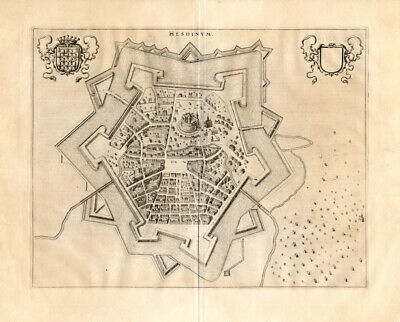
Free Shipping Location: Netherlands ABOUT US VISIT OUR STORE SALES SPECIALS Antique Map-FRANCE-BELGIUM-HESDIN-Blaeu-1650 Description: Published in Amsterdam by J. Blaeu ca. 1650. Artists ... moreand Engravers: Joan Blaeu(23 September 1596- 28 May 1673) was a Dutch cartographer. He was born in Alkmaar. The son of cartographer Willem Blaeu. In 1620 he became a doctor of law but he joined the work of his father. In 1635 they published the Atlas Novus(full title: Theatrum orbis terrarum, sive, Atlas novus) in two volumes. Joan and his brother Cornelius took over the studio after their father died in 1638. Joan became the official cartographer of the Dutch East India Company. Around 1649 Joan Blaeu published a collection of Dutch city maps named Tooneel der Steeden(Views of Cities) In 1651 he was voted into the Amsterdam council. In 1654 Joan published the first atlas of Scotland, devised by Timothy Pont. In 1662 he reissued the atlas with 11 volumes, and one for oceans. It was also known as Atlas Maior. A cosmology was planned as their next project, but a fire destroyed the studio completely in 1672. Joan Blaeu died in Amsterdam the following year. Subject: Plate: Hesdinum' Groundplan of Hesdin. Copper engraved bird's eye view of Hesdin in Belgium. From Blaeu's townbook of the southern Netherlands. First published in 1649. Blaeu composed his townbooks towards the end of the conflict with Spain and consequently the atlas became linked with the Dutch struggle for independence, proudly showing cities and stategic places. The town of Hesdin was forceably moved in the mid 16th century to its present site down in the Canche Valley by order of the Spanish Emperor Charles V. The old Hesdin was located in the hills and had been a dangerous French stronghold in the border wars between France and Spanish Flanders. Condition: Excellent; general age related toning. Size(in cm) The overall size is ca. 63 x 52 cm. The image size is ca. 50 x 39 cm. Size(in inch) The overall size is ca. 24.8 x 20.5 inch. The image size is ca. 19.7 x 15.4 inch. Medium: Copperplat
Buy It Now
$4.99 Shipping Location: Fairview, United States It is from John Marshall'sAtlas to the Life of Washington, published in Philadelphia,1834, a facsimile copy of the title page is included for authenticity. ... moreCondition: The map is in Good to Very Good condition with original hand coloring, blank on the reverse and a centerfold as issued.
|