Buy It Now
$6.95 Shipping Location: Dover, United States Issued c. 1862, Paris by Andriveau-Goujon. Very uncommon scarce mid 19th century folio sheet lithographed map with original hand color. Decorative piano ... morekey border. From a rare atlas of this era. 2" split at centerfold base which touches just into the border and is now closed on reverse with archival tape (all but invisible once map is laid open flat).
Buy It Now
$6.95 Shipping Location: Dover, United States Issued 1768, London by W.H. Toms. Oriens: Persia, India, Etc. Any age flaws mostly minor and easy to overlook or forgive. Mid 18th century engraved map ... morewith attractive hand color.
Buy It Now
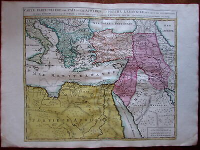
$11.85 Shipping Location: Dover, United States Carte Particuliere des Pais ou Les Apotres ont Preche l'Euan Gile; des Lieux les Plus Renommez de Leurs Voyages. Et de la Route de St. Paul a Rome. ... moreDressee pour bien entendre l'Histoire Sainte. Mediterranean. Arabia, Turkey, Greece, Armenia, North Africa) Issued Amsterdam. C. 1730-40 by Covens& Mortier. Fine mid-18th century engraved folio sheet map of the Mediterranean and Middle East. With original hand color. Quite interesting for the detailed depiction of Arabia. Armenia and Turkey during the time of the Apostles travels. In VG to near fine. Clean, well-preserved condition. A fine map. Sheet measures c. 24" W x 17" H. Printed area c. 18 1/4" W x 15" H. Folio. Tooleys Dictionary of Mapmakers. Vol. 1, p. 308. Marco van Egmond. Covens& Mortier. 3.3 R564. Everything we offer is guaranteed to be an authentic original antique item as described. We stand behind everything we sell. Important information for International Buyers* You may be charged customs. Taxes or other import duties by your country! this has nothing at all to do with us. Please do not hold us responsible if your Government wants to collect tax when you buy something outside of your country] Import duties. Taxes, and customs fees are not included in the item price or shipping cost. These charges are normally collected by the shipping service when the package is delivered or when you pick the item up. They are the buyer's responsibility and are not additional shipping charges. Please understand they have nothing to do with us and we have no control over them] Please check with your country's customs office to determine what these additional costs will be prior to bidding or buying. We do not know the various rules of your Customs office. There are a lot of countries in the world. Most with complex detailed variable laws in languages we don't read. Plus these laws are constantly being changed& revised] We won't under-value merchandise or mark the item as a gift on customs forms. Doing so is again
Buy It Now
$6.95 Shipping Location: Dover, United States Issued 1777, Amsterdam by Harrevelt & Changvien. Map by Bonne. Engraved by Krevelt. Late 18th century engraved map with attractive hand color. Dictionary ... moreof Mapmakers, vol.
Buy It Now
$4.99 Shipping Location: Fairview, United States It is from Monin & Fremin's. Atlas Universel, published in Paris by Logerot, c. 1835, a facsimile copy of the title page is included. Condition: The map ... moreis in Good to Very Good condition for its age, blank on the reverse, printed on a bright page with original hand color outlining as issued, basically as seen in the pic.
$20.00 Shipping Location: Poland Date of issue: 1863. THIS IS AN ORIGINAL MAP, NOT A RECENT COPY OR REPRODUCTION. by Dyonnet Ch., publ. by Pilon Abel, Paris (France). HAND COLOURED.
Buy It Now
Free Shipping Location: Schertz, United States This is an Authentic / Original Antique Atlas Map. It is not *NEW* or in *NEW* condition, it was printed in the year indicated. We sell only Old Antique ... moreMaps, not prints, copies or posters. See Photo for best description, this is the actual map you will receive.
Buy It Now
$3.75 Shipping Location: United States Superb, fine antique 1834 Delamarche handcolored map titled Orbis Antiqua Mappa Nova a Fr Delamarche Parisiis Apud Autorem in via diela Jardinet No. 13 ... more1833. I like how the year produced is right in the title, it dates the map nicely.
Buy It Now
$6.95 Shipping Location: Dover, United States Issued c.1806, Philadelphia. Engraved by Tanner. Early 19th century engraved map with attractive hand color.

Buy It Now
$9.99 Shipping Condition: Unspecified Location: LONDON, United Kingdom Asia Antique coloured map. 1909 Title of map: Asia' The image below shows an enlarged cross section from the centre of the map to show the level of ... moreprinted detail. This map is folding hence the centrefold line may show on the image below: DATE PRINTED: 1909 IMAGE SIZE: Approx 24.5 x 32.0cm. 9.5 x 12.5 inches(Large) Please note that this is a folding map. ARTIST/CARTOGRAPHER/ENGRAVER: Engraved by John Bartolomew& Co; Drawn by The Edinburgh Geographical Institute PROVENANCE: Cassell's Atlas" by J. G. Bartholomew. Published by Cassell and Company, Limited, London. Please note that virtually all antique and vintage maps and prints have been extracted from books, atlases or newspapers. TYPE: Antique coloured map VERSO: There is nothing printed on the reverse side. Which is plain CONDITION: Good; suitable for framing. Please check the scan for any blemishes prior to making your purchase. Virtually all antiquarian maps and prints are subject to some normal aging due to use and time which is not obtrusive unless otherwise stated. I offer a no questions asked return policy- see below. AUTHENTICITY: This is an authentic historic print. Published at the date stated above. I do not offer reproductions. It is not a modern copy. The term'original' when applied to a print means that it was printed at the first or original date of publication; it does not imply that the item is unique. Print' means any image created by applying an inked block to paper or card under pressure by any method including wood engraving, steel engraving, copperplate, wood cut and lithography. REMARKS: FRANCE: Gravures et Cartes anciennes. DEUTSCHLAND: Alte Lankarten und Stadt ansichten. ITALIA: Stampe& Mappe antiche. ESPAÑA: Mapas antiquos y impresiones antiguas. E and OE. Force Majeure. English law shall apply. RETURNS POLICY: I offer a no questions returns policy. All I ask is that you pay return shipping and mail back to me in original condition. Suitably packed& insured, within 14 days of receipt.
$4.13 Shipping Location: Richland, United States Map is in colour and has vertical centre fold. sheet size is 49 x 61cm. Sheet is clean, bright and crisp. Scale 1:15,000,000. First printing of this edition.
Buy It Now
$4.99 Shipping Location: Fairview, United States The Harmsworth Universal Atlas and Gazetteer, London, circa 1907. A copy of the title page is included for authenticity. It is not mounted nor matted, ... morebeing sold as a single sheet as seen in the main pic.
Buy It Now
$4.95 Shipping Location: Dover, United States Issued 1828, London by S. Arrowsmith. Early 19th century engraved map with original outline hand color. Asia Veteribus Nota cum Insulis. Dictionary of ... moreMapmakers, vol.
Buy It Now
$11.85 Shipping Location: Dover, United States Issued 1792, Amsterdam by Jan Elwe after Delisle for l'Academic Royal des Sciences a Paris. Wonderful details, including Nile source lakes and mountains, ... moreendless notes about tribes, kings and kingdoms, speculative and apocryphal terrain features, etc.
Buy It Now
$6.95 Shipping Location: Dover, United States Issued 1768, London. Engraved by Toms. Any age flaws mostly minor and easy to overlook or forgive. Arabia, Petraea et Deserta. Mid 18th century engraved ... moremap with attractive hand color.
Buy It Now
$6.95 Shipping Location: Dover, United States Large, oversized early 20th century color lithographed map. This size allows for much more detail. Issued 1908, Chicago by Rand McNally. Original center ... morefold as issued.
Buy It Now
Free Shipping Location: Monroeville, United States Date - 1869. inventory# j71296.
Buy It Now
$6.95 Shipping Location: Dover, United States Attractive and detailed early 20th century color lithographed map. Colors remain bright. Original centerfold as issued.
Buy It Now
$9.95 Shipping Location: Fort Lauderdale, United States A finely detailed mid-1800's engraved map by J.H. Colton.
Buy It Now
$4.50 Shipping Location: Oakland, United States Antique 19th century hand colored map of Asia. This is an original bookplate from Cornell's Primary Geography: Forming part first of a systematic series ... moreof school geographies by S. S. Cornell. Revised Edition.
Buy It Now
$4.95 Shipping Location: Dover, United States Issued 1868, Edinburgh by William Blackwood & Sons. Engraved by Keith Johnston. (Asia, Ottoman Empire, Arabia, Persia, Iran, Afghanistan, Baluchistan, ... moreRussia, India, British Raj, Qing Empire, China, Tibet, Nepal, Burma, Southeast Asia, Japan, Korea, Philippines).
Buy It Now
$9.99 Shipping Condition: Unspecified Location: LONDON, United Kingdom PROVENANCE: "Orbis Terrarum Veteribus Noti descriptio"; by A. Arrowsmith, Published by E. Williams, London. Antique copperplate map with original outline ... morecolour, 1828. DATE PRINTED: 1828. Title of map:'Asia'.
Buy It Now
$9.00 Shipping Location: Cedar Park, United States One 1831 Daniel Lizars Saudi Arabia map, along with an original printing catalog from Edinburgh. Pre owned. Has been folded in the middle and along one ... moreedge. Split along the middle fold and being repaired on the back.
Buy It Now
$4.99 Shipping Location: Fairview, United States The pics are of the actual map. An Authentic Antique Map: Not a Modern Reproduction!
Buy It Now
$11.86 Shipping Location: ILKLEY, United Kingdom Provenance: 'Justus Perthes' Atlas Antiquus. Taschen-Atlas der Alten Welt von Dr. Alb. Kampen', Gotha, Justus Perthes, 1898. Date: 1898.
Buy It Now
$4.45 Shipping Location: Manassas, United States Year of printing: 1898. Green color around the map in the photo is a contrasting background on which the map was photographed. The map details is sharper ... morethan the photo of the map. Map Specifics Type of print: Lithograph - Original antique map.
Buy It Now
$6.80 Shipping Location: Santa Barbara, United States 1866 Johnson's Asia Rare Atlas Map, India, Arabia, Turkey, Siam, Persia, China This is a colorful map from Johnson's Atlas showing great detail of Asia. ... moreThe Empires of Asia are delineated. This is a colorful map from Johnson's Atlas showing great detail of Asia.
Buy It Now
$5.00 Shipping Location: Canada DATE OF ISSUE: 1959.
Buy It Now
Free Shipping Location: Cass City, United States This listing is for Asia Ottoman Empire Arabia China India Japan Korea Russia 1826 Engraved Map. Please refer to all photos for more details as they are ... morethe best part of the description. Photos are of the actual item that you will receive.
Buy It Now
Free Shipping Location: Portland, United States Antique Map Excellent condition antique map. Professionally framed with all the best archival material and methods. Very light wear from age; still in ... moreexcellent condition with no major damage. Colored by hand. Frame is 23.5 x 21 inches; map is 20 x 17 inches. Froo www.froo.com | Froo Cross Sell. Free Cross Sell, Cross promote, eBay Marketing, eBay listing Apps, eBay Apps, eBay Application.
Buy It Now
$11.85 Shipping Location: Dover, United States Corrigee" at top right beside title, etc. Issued 1792, Amsterdam, by Jan Elwe. (Northeastern Africa, Kingdom of Agnor, Ethiopia, Nubia, Egypt, Nile River, ... moreTripoli, Desert of Seth). Fine and uncommon 18th century engraved folio sheet map with original hand color.
Buy It Now
$6.95 Shipping Location: Dover, United States Issued 1846, Paris. Engraved by Thierry. Mid 19th century antique engraved map with original hand color.
Buy It Now
$4.99 Shipping Location: Fairview, United States There is another map on the reverse. The pics are of the actual map. An Authentic Antique Map: Not a Modern Reproduction!
Buy It Now
$25.00 Shipping Location: Belvedere Tiburon, United States In the south, it extends west from Aden along the southern coast until Bab al-Mandeb and Parim Island at the opening to the Red Sea. In the north, the ... moremap covers part of what is now the southwestern corner of Saudi Arabia, including the towns of Jizan and Abu Arish.
$15.00 Shipping Location: Poland Date of issue: 1809 (dated map). THIS IS AN ORIGINAL MAP, NOT A RECENT COPY OR REPRODUCTION. by Lapie Pierre., engr. by Tardieu & Giraldon, Paris (France). ... moreHAND COLORED.
Buy It Now
$4.99 Shipping Location: Fairview, United States There is a date of 1879 on the bottom left corner in small print just inside the border of the map. The labeling language is in German. Overall a beautiful ... moremap in great condition. An Original Antique Map: Not a Modern Reproduction!
$16.00 Shipping Location: Poland Date of issue: ca 1750. THIS IS AN ORIGINAL MAP, NOT A RECENT COPY OR REPRODUCTION. Origin of the map: "The Modern Part of the Universal History.", engr. ... moreby Basire Isaac. by Richardson S. & Co, London (United Kingdom).
Buy It Now
$10.00 Shipping Location: Cyprus Title: Turcici Imperii Deccriptio. His father was Pasquale Magini, a citizen of Padua. Origin: Geographiae universae tum veteris tum novae absolutissimum ... moreopus, duobus voluminibus distinctum. Antonio Magino Patavino Ptolemaeus, Claudius; Magini, Giovanni Antonio.
Buy It Now
$11.85 Shipping Location: Dover, United States Issued 1816, London for Thomson. Arabia, Egypt, Abyssinia, Red Sea, &c. Large early 19th century folio map with lovely hand color.
Buy It Now
$6.95 Shipping Location: Dover, United States Charming small mid 19th century map with original outline hand color. Despite the relatively small size nicely engraved with a remarkable level of tiny ... moredetail.
Buy It Now
$15.00 Shipping Location: Turkey Conditi on : very good.
$25.00 Shipping Location: Perugia, Italy French 1552, 1556, 1560, 1565, 1568, 1575. In 1529 Munster settled in Basle, where he was to spend the rest of his life. Very strong and dark impression ... moreon good paper. Paper with chains. Map uncolored.
Buy It Now
$7.00 Shipping Location: North Wales, United States 1897 ANTIQUE CENTURY ATLAS MAP-ARABIA, OMAN, ADEN, PART OF TURKEY ORIGINAL ANTIQUE ATLAS MAP PLEASE SEE PHOTOS AS PART OF THE DESCRIPTION CONDITION: MAP ... moreIS IN GOOD CONDITION. SIZE: APPROXIMATELY 15" X 23" SHIPPING: U.S. FIRST CLASS RATE - $6.00 - ANY ITEM WHICH SELLS FOR OVER $100 WILL REQUIRE INSURANCE WE COMBINE SHIPPING FOR MULTIPLE WINS. THANK YOU FOR YOUR INTEREST IN OUR AUCTIONS!.
Buy It Now
$30.00 Shipping Location: Paris VI, France Antique copper engraved Map of the Arabian Peninsula, by Rigobert Bonne (1727-1794). Edition : Paris, 1780. Title of the Map.
Buy It Now
$4.69 Shipping Location: Greenacres, United States Among the counties, cities, and natural features labeled on the map are Siam, Kingdom of Hejaz, Siberia, Persian Gulf, Tibet, Arabian Sea, the Great Wall, ... moreFormosa, Bombay, Delhi, Teheran, Caspian Sea, Damascus, Jerusalem, Himalaya Mountains, Saigon, Singapore, the Chinese Empire, Arabia, and Korea (spelled Corea).
Buy It Now
$4.99 Shipping Location: Fairview, United States A copy of the title page is included for authenticity. Overall a beautiful large map in great condition. Condition: The map is in Good to Very Good condition, ... moreblank on the reverse with a centerfold as issued.
$16.00 Shipping Location: Poland Date of issue: 1816. THIS IS AN ORIGINAL MAP, NOT A RECENT COPY OR REPRODUCTION. by Desray J., Paris (France). HAND COLORED.
Buy It Now
$6.95 Shipping Location: Dover, United States Issued 1898, United States. Original late 19th century lithographed map with original hand color. Nice clean fresh example, close to as issued condition.
Buy It Now
$14.00 Shipping Location: Poland Date of issue: 1808 (dated map). THIS IS AN ORIGINAL MAP, NOT A RECENT COPY OR REPRODUCTION. Origin of the map: Arrowsmith & Lewis, "New and Elegant General ... moreAtlas. "; publ. by Longman & Co., London (England).

Buy It Now
$5.00 Shipping Location: Galena, United States Auction Wizard 2000 Listing Template- AW2KLOT#2664 Please note that Customs delays for international shipping have been SIGNIFICANT lately- days or even ... moreweeks longer than they should be! Please take this into consideration Our goal is 5 star service! If you feel we have not lived up to a 5 star rating. Please contact us as we only want 100% satisfied customers and NO misunderstandings! 1855 MAP OF PERSIA ARABIA Original J H Colton Hand Colored RARE THOUSANDS of other WONDERFUL items at A Better Online Bookstore! 1855 MAP OF PERSIA ARABIA Original J H Colton Hand Colored RARE* $119.65 1855 MAP OF PERSIA ARABIA Original J H Colton Hand Colored RARE PERSIA- ARABIA This is an original antique map published by J.H. Colton& Co. 1855. Excellent detail and many Place Names. Beautiful Hand coloring! Edge tears and wear at edges. Text on verso of map* SCARCE* Overall size: 17 1/8" x 14 1/4" This is a ORIGINAL and Authentic Vintage Map! A REMINDER to our International customers; We ship worldwide but International shipping costs will differ depending on destination and regulations. It is suggested that you contact us prior to bidding or buying this item for exact shipping costs to your locale. We always quote the cheapest shipping method but please realize that insurance may not be an option with the lowest cost shipping method. We ship USPS to all locations. We CANNOT mark customs forms as a'Gift' Save on shipping by combining winning bids from Our Other AUCTIONS! BID WITH CONFIDENCE: We HAVE BEEN AN EBAY DEALER SINCE 1997 A Better Online Bookstore is a premier seller of fine books. Documents, ephemera and collectibles. Specializing in the 18th through the 20th centuries. We individually select each of our items in an effort to offer you the VERY BEST IN OLD AND RARE COLLECTABLES! Please visit our auctions often. Please click here to add us as a Favorite Seller! Please view our other eBay auctions to see many more wonderful items! We gladly combine shipping! Each
$4.13 Shipping Location: Richland, United States Map is in colour and has vertical centre fold. sheet size is 49 x 61cm. Sheet is clean, bright and crisp. Scale 1:4,000,000. Includes : Kuwait, Bahrain, ... moreStrait of Hormuz, Qatar, Arabia, parts of Iraq, Iran, Egypt, Sudan, Red Sea, Persian Gulf and Gulf of Oman.
Buy It Now
$4.75 Shipping Location: Wortham, United States ASIA INCLUDING CHINA INDIA PERSIA RUSSIA AFGANISTAN ARABIA JAPAN PLUS MORE. ORIGINAL 1880. COLORED MAP.
Buy It Now
$4.95 Shipping Location: Dover, United States Issued 1875, Gotha by Justus Perthes by Stieler for Stulpnagel. (Asia, Middle East, Ottoman Empire, Russia, Arabian Peninsula, Iran, India, Mongolia, ... moreChina, Japan, Korea, Southeast Asia, Philippines, Sumatra, Borneo).
Buy It Now
$6.00 Shipping Location: Columbus, United States This map is in Very Good condition, with bright hand coloring, but also with a few faint spots of foxing, and a small black spot near the center. The ... moremap shows Hindoostan, Chinese Empire, Arabia, Australia, Russia, and more.
Buy It Now
$6.24 Shipping Location: DERBY, United Kingdom EGYPT & NUBIA. CENTRE FOLD AS PUBLISHED. PRINTED COLOUR. ORIGINAL ANTIQUE MAP. THIS ENGRAVING / PRINT IS OVER 135 YEARS OLD, AND. NOTA MODERN COPY. IMAGE ... moreSIZE 12.25 X 9ins.
Buy It Now
$25.00 Shipping Location: Belvedere Tiburon, United States The distance between the Red Sea and Persia was too big, and thus Arabia was stretched to fill the gap, mainly because Ptolemy knew the entrance to the ... moreRed Sea was very narrow; thus, he had to make the shape fit.
Buy It Now
$25.00 Shipping Location: Egypt .
Buy It Now
$14.00 Shipping Location: Poland Date of issue: 1907. THIS IS AN ORIGINAL MAP, NOT A RECENT COPY OR REPRODUCTION. Origin of the map: Schrader F., Prudent F., Anthoine E., "Atlas de Geographie ... moreModerne.", publ.
Buy It Now
$6.00 Shipping Location: Hungary CHINA, Russia, JAPAN, INDIA, ARABIA. copper engraved MAP. size: 32 cm x 26 cm.
Buy It Now
$6.95 Shipping Location: Dover, United States Issued 1899, Edinburgh by W. & A.K. Johnston for the Royal Geographic Society. Scarce detailed 19th century lithographed folding map issued in a geographical ... moreperiodical, inherently scarce thus. War Office.
|