|
|
Order by: Available to: This site contains affiliate links for which I may be compensated
|

Buy It Now
$5.02 Shipping Location: CARDIFF, United Kingdom ANTIQUE COLOUR FOLDING MAP OF YORKSHIRE. THE EAST RIDING 1868 N.B. PLEASE CHECK MEASUREMENTS CAREFULLY AND PLEASE NOTE THAT MAP HAS FOLD/CREASE TO CENTRE(SEE ... moreSCANNED IMAGE) WHICH WILL PRESS OUT WHEN FRAMED TYPE: ANTIQUE COLOUR FOLDING MAP DATE: 1868 PROVENANCE: THE NATIONAL GAZETTEER OF BRITAIN AND IRELAND PUBLISHED DATE: 1868 CONDITION: VERY GOOD FOR AGE. CHECK SCANNED IMAGE FOR ANY MINOR BLEMISHES. EXCELLENT FOR MOUNTING AND FRAMING COLOUR: COLOUR VERSO: BLANK TO REVERSE SIZE INCLUDING MARGINS(approx) 33cms x 27cms AUTHENTICITY: All printed engravings/prints are authentic originals printed at the date stated and NOT photocopies/reproductions and in some cases may have discolouring due to age. The word original does not make this item unique- The term'Print' means any image created by applying an inked block to paper or card under pressure by any method including wood engraving. Steel engraving, copperplate, wood cut and lithography- ALL PRINTED ENGRAVINGS/PRINTS HAVE BEEN EXTRACTED FROM BOOKS/PERIODICALS AND ARE SINGLE PAGES UNLESS STATED OTHERWISE- All prints have been carefully saved and removed from a heavily damaged book. Where possible all explanatory text has been left intact adding to the interest of the print. POSTAGE: FREE WORLDWIDE DELIVERY All prints are sent out in film front bags and cardboard backed envelopes. We post within 1 business days of cleared payment usually same business day if payment has cleared by 1.00pm. We always obtain proof of posting We value positive feedback so in the unlikely event of any problems after sale. Please let us know before leaving negative or neutral feedback and we will do our best to rectify the problem. We are pleased to offer a no questions asked returns policy. We just ask that you pay return postage and return the item in its original condition and packaging ensuring postal insurance is obtained. Within 14 days of receipt. Refunds will be initiated once goods have been received by us. Powered by
Buy It Now
$10.04 Shipping Condition: Unspecified Location: LONDON, United Kingdom 'Barnehurst, New Bridge, Erith, North End, Erith, Slades Green, Crayford'. Title of print (not printed on the page):'Barnehurst, New Bridge, Erith, North ... moreEnd, Erith, Slades Green, Crayford'. DATE PRINTED: 1933.
Buy It Now
$6.95 Shipping Location: Dover, United States Issued 1885, Glogau by C. Flemming. Uncommon and very detailed 19th century German color lithographed map with original outline hand color. Original center ... morefold as issued. Dictionary of Mapmakers, vol.
Buy It Now
$6.95 Shipping Location: Dover, United States Palace of Whitehall, in Charles The Second's Reign: Anno 1680. Issued 1829, London by Thomas Hurst & Edward Chance. Highly detailed early 19th century ... morehistorical plan of this famous English location.
Buy It Now
$6.95 Shipping Location: Arlington, United States I will work hard to make sure you are satisfied and you can always start a case if you are not happy with my response.
Buy It Now
$6.95 Shipping Location: Dover, United States Issued 1890, NY by Scribner & Black. Scarce oversized folio sheet late 19th century color lithographed map.
Buy It Now
$6.95 Shipping Location: Arlington, United States I will work hard to make sure you are satisfied and you can always start a case if you are not happy with my response.
Buy It Now
$6.95 Shipping Location: Dover, United States Issued 1885, Glogau by C. Flemming. Uncommon and very detailed 19th century German color lithographed map with original outline hand color.
Buy It Now
$6.95 Shipping Location: Dover, United States Issued 1725-45, London. Engraved by H. Moll. Fine mid-18th century engraved map.
Buy It Now
$6.95 Shipping Location: Arlington, United States I will work hard to make sure you are satisfied and you can always start a case if you are not happy with my response.
Buy It Now
$4.00 Shipping Location: Freeport, United States P. 24 & 24.
Buy It Now
$6.27 Shipping Location: DERBY, United Kingdom AFRICA ANTIQUA. R WILKINSON. ORIGINAL HAND COLOUR. ORIGINAL ANTIQUE MAP. PRINTS FROM THE ILLUSTRATED LONDON NEWS, GRAPHIC. THIS ENGRAVING / PRINT IS OVER ... more215 YEARS OLD, AND. NOTA MODERN COPY. IMAGE SIZE 11.25 X 8.75 ins 28.575 X 22.225 cms.
Buy It Now
$11.92 Shipping Location: ILKLEY, United Kingdom Title / Subject: Sussex.
Buy It Now
$10.03 Shipping Location: GLASGOW, United Kingdom Provenance: Taken from The Universal Atlas. Published for the Atlas Publishing Co by Cassel & Co, London 1893. We do not deal in facsimiles or reproductions ... moreof any kind. We grade all prints individually into four levels - Excellent, Very Good, Good, and Fair.
Buy It Now
$4.00 Shipping Location: Rockville, United States Up for sale is a nice hand colored stone engraved map published by Charles DeSilver. Published 1856. Overall map is in good condition. Several small tears ... moreon the left side border. Other chipping at edges, small dings and nicks here and there mostly impacting boarder area.
Buy It Now
Free Shipping Location: Netherlands Description: This authentic print originates from: 'Notitia orbis antiqui, sive geographia plenior �', by Christoph Cellarius, ed. published in Leipzig ... moreby Johann Frederick Gleditsch in 1731-32. Ref. Brunet I, 1724. Ebert 3868. An early standard work on the geography of Classical Antiquity first published in 1686. Artists and Engravers: Author: Christoph Cellarius (1638 - 1707) or Christopher Keller was a German scholar, historian and textbook publisher. Cellarius held academic positions in both Weimar and Halle. Cellarius's most important work was his 1683 publication of 'A Universal History Divided into an Ancient, Medieval, and New Period.
Buy It Now
$10.03 Shipping Location: GLASGOW, United Kingdom Published by GW Bacon & Co Ltd, 127 Strand, London. We do not deal in facsimiles or reproductions of any kind.
Buy It Now
$10.03 Shipping Location: GLASGOW, United Kingdom We do not deal in facsimiles or reproductions of any kind. We grade all prints individually into four levels - Excellent, Very Good, Good, and Fair. Good ... moreand fair may have more general foxing. We try to represent all the images to the best of our ability, and we ask you to check the above scans before purchasing.
Buy It Now
$6.95 Shipping Location: Dover, United States Issued 1850, Philadelphia by Thomas Cowperthwait. Holland & Belgium. Fine scarce mid 19th century lithographed map with original hand color.
Buy It Now
$13.80 Shipping Location: MANCHESTER, United Kingdom The date and publishing details are printed at the bottom of the map. This is an original antique which is 192 years old.
Buy It Now
$10.04 Shipping Location: BATH, United Kingdom Persia by Selina Hall1854. Selina Hall (1780?. –1853) was a British engraver and printer working in London. The similarity in their signatures caused ... moreextensive misattribution of her works to her deceased husband.
Buy It Now
Free Shipping Location: Training Battalian S.O, India Material : Brass & Wood. Finish : Antique. We reply within 24 hours. Weight : 0.980 kg Approx.
Buy It Now
$11.92 Shipping Location: SHREWSBURY, United Kingdom SHOOTERS HILL, WOOLWICH COMMON, ELTHAM. Published London 1891 by George Philip & Son.
Buy It Now
$30.12 Shipping Location: NORTHWICH, United Kingdom It is divided into Shires - Radnor, Breknock, Glamorgan, Carmardhen, Cardigan, Pembroke etc and divided further into Hundreds. In very good condition. ... moreOne vertical fold. 39 x 44 cm.
Buy It Now
$10.04 Shipping Location: POOLE, United Kingdom SURREY DRAWN BY THOMAS BADESLADE ENGRAVED BY WILLIAM TOMS c1742 AN INTERESTING COPPER ENGRAVED COUNTY MAP WITH ADDITIONAL INFORMATION ON THE MAJOR TOWNS ... moreWITH DETAILS ON MARKET DAYS, FAIRS, MEMBERS OF PARLIAMENT AND OTHER POINTS OF INTEREST. DATED SEPT 29, 1742 THIS ENGRAVED MAP IS IN EXCELLENT CONDITION WITH RARE CONTEMPORARY HAND COLOURING. THERE IS A CENTREFOLD CREASE AS PUBLISHED. THIS IS A GENUINE ANTIQUE MAP OVER 270 YEARS OLD. THE MAP MEASURES APPROX 7x 6.25 ins (17.5 x 16 cms) THOMAS BADESLADE (fl. 1717-1774) WAS A SURVEYOR, DRAUGHTSMAN, MATHEMATICIAN AND ENGINEER WORKING IN LONDON AND WALES. WILLIAM HENRY TOMS (fl. 1723-1761) WAS A ENGRAVER, PRINTSELLER AND PUBLISHER WORKING IN LONDON.
Buy It Now
$11.71 Shipping Location: Latvia
Buy It Now
$11.71 Shipping Location: Latvia
Buy It Now
$11.71 Shipping Location: Latvia Beautiful old map on quality paper EXCELLENT condition and rescued from a disbound Atlas THIS MAP IS AN ORIGINAL- APPROXIMATELY 110 YEARS OLD AND NOT ... moreA REPRODUCTION Produced by Bartholomew& Robertson for their Atlas of The British Empire 1905 This single page map measures approximately 11 inches by 8 1/2 inches(280mm x 215mm) Printed on quality paper There will be another map/part map on the reverse Please message with any questions regarding this item BEST OFFERS PLEASE FOR A QUICK SALE AT A FAIR PRICE If you like the item. But do not like the price, then make a realistic offer to us using the MAKE OFFER BUTTON Powered by
Buy It Now
$10.04 Shipping Condition: Unspecified Location: LONDON, United Kingdom Places marked on the map include: Dartmoor Plymouth Exeter Torquay. 'South Devon'. Caption below picture:'South Devon'. DATE PRINTED: 1912. CONDITION: ... moreGood; suitable for framing. The map you will receive is in good condition but there may be minor variations in the condition from that shown in the image.
Buy It Now
$11.71 Shipping Location: Latvia
Buy It Now
$10.04 Shipping Condition: Used Location: LONDON, United Kingdom 'Ratisbon (Regensburg)'. Title of map:'Ratisbon (Regensburg)'. Antique engraved sketch map, 1885. DATE PRINTED: 1885. TYPE: Antique engraved sketch map. ... moreThe image below shows an enlarged cross section from the centre of the map to show the level of printed detail.
Buy It Now
$10.04 Shipping Condition: Used Location: LONDON, United Kingdom PROVENANCE: "The Authentic map directory of South - West Yorkshire"; Produced and published by "Geographia" Ltd, London [Authentic map directory of South-West ... moreYorkshire]. DATE PRINTED: 1935. CONDITION: Good; suitable for framing.
Buy It Now
$3.75 Shipping Location: WALSALL, United Kingdom The map is in impeccable shape, showcasing the beauty of Athens, the county of Athens and Greece as a whole.
Buy It Now
$11.71 Shipping Location: Latvia
Buy It Now
$15.06 Shipping Location: NORWICH, United Kingdom Original 1960s Antique London Map. Odd marks consistent with age.
Buy It Now
$4.00 Shipping Location: United States Superb, large, very fine, antique circa 1700 copperplate engraved map, produced in France. Printed on fine period handmade paper, with no printing on ... moreverso. Attractive and detailed map. The size of the map is a large 17.5" by 21".
Buy It Now
$4.96 Shipping Location: CHESTER LE STREET, United Kingdom An Antique - Siege of Castle Of Burcos. by A K Johnstone. From 10th September to 21st October 1812. By The Allies Under Wellington. The Life Of Wellington ... more1900 (2nd Edition). Condition: Very Good. Suitable for framing.
Buy It Now
$15.06 Shipping Location: NORWICH, United Kingdom Original 1930 Antique London Map. Odd marks consistent with age.
Buy It Now
$10.03 Shipping Location: GLASGOW, United Kingdom Published by Justus Perthes, Gotha 1926. We grade all prints individually into four levels - Excellent, Very Good, Good, and Fair. Good and fair may have ... moremore general foxing. We try to represent all the images to the best of our ability, and we ask you to check the above scans before purchasing.
Buy It Now
$8.78 Shipping Location: BATH, United Kingdom Leicestershire and Rutland by John Harrison. John Harrison (active 1784-91) was a printer and publisher working in London in the later halve of the eighteenth ... morecentury. The engraver was E. Sudlow. Blank on reverse.

Buy It Now
$7.84 Shipping Location: Canada WELCOME TO VINTAGE PAPER- CONDITION AS SHOWN-ALL WINS OF TWO OR MORE ITEMS RECEIVE A DISCOUNT PLEASE REQUEST MORE PICTURES IF NEEDED B UYER MAKES FINAL ... moreCONDITON DECISION PLEASE REQUEST MORE PICTURES IF NEEDED AND PLEASE ASK ANY QUESTIONS BEFORE BIDDING INTERNATIONAL BUYERS ARE WELCOME WE STRIVE TO SATISFY OUR CUSTOMERS-ALL ITEMS ARE SHIPPED VERY WELL PROTECTED TO INSURE THEY ARRIVE TO YOU AS THEY LEFT HERE WE DO HOLD ITEMS FOR COMBINED SHIPPING WHEN POSSIBLE.SO PLEASE CONTACT US IF YOU PLAN ON COMBINING SHIPPING OR HAVE ANY OTHER REQUESTS PLEASE VIEW OUR FEEDBACK-WE STRIVE FOR 100 PERCENT SATISFACTION I do combine shipping when possible and have many items yet to list. Please request additional photos and submit any questions before bidding please! MO’s are accepted and international buyers are welcome. I will hold items for combined shipping up to 7 days. I will be listing several items daily. All items will be shipped very secure to ensure it arrives in the same condition as it left. DD/12/12
Buy It Now
$47.68 Shipping Location: United Kingdom ‘BIRD’S - EYE VIEW OF LIVERPOOL, AS SEEN FROM A BALLOON, 1885’. Engraved by W. L. Wyllie and H. W. Brewer for The Graphic 1885. 56 x 78 cm. Uncoloured ... moreas issued. Excellent condition.
Buy It Now
$15.06 Shipping Location: NORWICH, United Kingdom Original 1930 Antique London Map. Odd marks consistent with age.
Buy It Now
$28.87 Shipping Location: RIPON, United Kingdom Date: 1801. Trading since 1976 in Ripon, North Yorkshire, Hornseys’ specialises in fine quality products across many different range. Engraver: CHARLES ... moreSMITH. VERY MINOR AGE STAINING. SLIGHT OFFSETTING.
Buy It Now
$6.27 Shipping Location: NOTTINGHAM, United Kingdom W & A K JOHNSTON. PRINTED COLOUR. ORIGINAL ANTIQUE MAP. THIS ENGRAVING / PRINT IS OVER 120 YEARS OLD, AND. PRINTS FROM THE ILLUSTRATED LONDON NEWS, GRAPHIC. ... moreNOTA MODERN COPY. IMAGE SIZE 9.75 X 6.75ins.
Buy It Now
$10.04 Shipping Condition: Unspecified Location: LONDON, United Kingdom Antique map, 1898. DATE PRINTED: 1898. VERSO: There is nothing printed on the reverse side, which is plain.
Buy It Now
$37.97 Shipping Location: KIRKCALDY, United Kingdom NEW ZEALAND 1851 JOHN TALLIS 19TH CENTURY DECORATIVE ANTIQUE ENGRAVED MAP.
Buy It Now
$15.06 Shipping Location: NORWICH, United Kingdom Original 1960s Antique London Map. Odd marks consistent with age.
Buy It Now
$10.04 Shipping Condition: Unspecified Location: LONDON, United Kingdom 'Battle of Ocana, 19th November 1809'. Title of map:'Battle of Ocana, 19th November 1809'. TYPE: Antique hand-coloured engraved map. This map was published ... morein 1848 but it may depict an earlier representation of the area shown dated 1809 and the mapmaker may have drawn on an earlier original work.
Buy It Now
$11.92 Shipping Location: ILKLEY, United Kingdom An attractive steel-engraved, hand-coloured map of Spain, Portugal and part of North Africa. It was published in Paris in c.1855 in Felix Ansart's 'Petit ... moreAtlas Historique et Geographique'.
Buy It Now
$8.70 Shipping Location: Iron River, United States
Buy It Now
$12.00 Shipping Location: Roma, Italy BARBANEGRE - BERCKHEIM. 1814 L'EMPEREUR A' REIMS. Beautiful original engraving of XIX century. LITTLE DEFECTS ON WHITE MARGIN, IMAGE IN GOOD CONDITION. ... moreSIZE OF SHEET CM 26,5 X 17,5 APPROX.
Buy It Now
$13.68 Shipping Location: BOURNEMOUTH, United Kingdom DOUBLE-PAGE MAP- NORTH SEA AND BALTIC SEA TRAFFIC MAP,PAGE 33-34 FROM ANDREE GREAT WORLD ATLAS- 1914. FROM - ANDREE GRANDE ATLANTE GEOGRAFICO UNIVERSALE/SESTA ... moreEDIZIONE/-SIXTH EDITION. VERY GOOD CONDITION - SEE SCAN.

Buy It Now
$4.75 Shipping Location: Catonsville, United States History-Image Photo. Map& Poster Archive Search in titles& descriptions Browse Photographs by Category Historic Posters Historic Maps Shipping& ... morePayment We combine shipping so you only pay one shipping charge regardless of how many items you purchase U.S. $ 8.95 Canada& Mexico $ 25.00 International $ 35.00 You will receive an email at the close of auction. Click on the payment link to complete payment. We accept all forms of auction payments that are allowed by ebay. You can also pay for your purchase over the phone with a credit card: 503) 408-2360 See our Framing work work Who are you buying from? This is a very large General Land Office map of the United States and territories. 1890. From map: Map of the United States and territories. With adjacent parts of Canada and Mexico also part of the West India islands, showing the extent of public surveys, Indian, military, and forest reservations, rail roads, canals, national parks and other details, compiled from official surveys of the General Land Office and other authentic sources. Under the direction of the Hon. Lewis A. Groff, Commissioner. A.F. Dinsmore, Chief, Draughting Division. 1890. Isaac Friedenwald, Photo. Litho. Balto. Md. inset) Territory of Alaska. Actual map is much sharper and detailed than the low resolution scanned image used here. Map measures approximately 36" by 54" 92 by 137cm) The map is a modern reprint. It is reprinted(a modern reprint) using premium semi-matte. Japanese paper and Ultrachrome ink, which has an archival rating of 125+ years. For more information about how the maps are made see our Custom Framing& Matting Options We offer a variety of sizes and options for framing your purchase. to see frames and prices Example of map detail: Frequently Asked Questions Is the resolution disappointing? No. Is the simple answer. Because we are dealing with historical pieces from a wide range of regions, creators and time periods, there is variation in the quality. However, we always ask ourselves if we would be ple
Buy It Now
$15.06 Shipping Location: NORWICH, United Kingdom Original 1926 Antique Map. There may be minor marks consistent with age.

Buy It Now
$10.04 Shipping Condition: Used Location: LONDON, United Kingdom Sheet 15 of London Vintage colour map. 1933 Title of map: Sheet 15 of London' The image below shows an enlarged cross section from the centre of the ... moremap to show the level of printed detail: DATE PRINTED: 1933 IMAGE SIZE: Approx 17.0 x 20.5cm. 6.75 x 8 inches(Medium) ARTIST/CARTOGRAPHER/ENGRAVER: G.W. Bacon& Co PROVENANCE: Bacon's Pocket Atlas of London" Published by G.W. Bacon& Co. Ltd. London[1933 edition] TYPE: Vintage colour map VERSO: There are images and/or text printed on the reverse side of the picture. In some cases this may be visible on the picture itself(please check the scan prior to your purchase) or around the margin of the picture CONDITION: Good; suitable for framing. However. Please note: This map was originally printed as two separate pages which have been professionally joined to form a single sheet; The image shown may have been taken from a different example of this map than that which is offered for sale. The map you will receive is in good condition but there may be minor variations in the condition from that shown in the image. Please check the scan for any blemishes prior to making your purchase. Virtually all antiquarian maps and prints are subject to some normal aging due to use and time which is not obtrusive unless otherwise stated. I offer a no questions asked return policy- see below. AUTHENTICITY: This is an authentic historic print. Published at the date stated above. I do not offer reproductions. It is not a modern copy. The term'original' when applied to a print means that it was printed at the first or original date of publication; it does not imply that the item is unique. Print' means any image created by applying an inked block to paper or card under pressure by any method including wood engraving, steel engraving, copperplate, wood cut and lithography. REMARKS: FRANCE: Gravures et Cartes anciennes. DEUTSCHLAND: Alte Lankarten und Stadt ansichten. ITALIA: Stampe e Mappe antiche. ESPAÑA: Mapas antiquos y impresiones antiguas. E and OE. Fo
Buy It Now
$11.92 Shipping Location: ILKLEY, United Kingdom Date: 1877.
Buy It Now
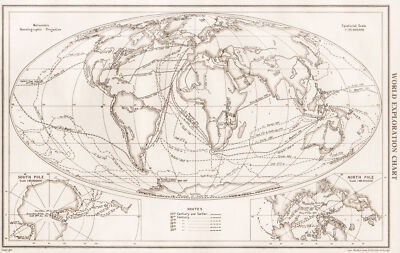
$10.04 Shipping Condition: Unspecified Location: LONDON, United Kingdom World Exploration Chart; Inset maps of South pole; North Pole Vintage map; Equatorial Scale 1:125.000,000; Scale 1:85,000,000; Scale 1:85,000,000, 1952 ... moreTitle of map: World Exploration Chart; Inset maps of South pole; North Pole' The image below shows an enlarged cross section from the centre of the map to show the level of printed detail: DATE PRINTED: 1952 IMAGE SIZE: Approx 21.0 x 33.0cm. 8.25 x 13 inches(Large) ARTIST/CARTOGRAPHER/ENGRAVER: John Bartholomew PROVENANCE: The Citizen's Atlas of the World" by John Bartholomew; Published by John Bartholomew& Son limited. Edinburgh; 10th Edition. Please note that virtually all antique and vintage maps and prints have been extracted from books, atlases or newspapers. TYPE: Vintage map; Equatorial Scale 1:125.000,000; Scale 1:85,000,000; Scale 1:85,000,000 VERSO: There is another map or maps printed on the reverse side of the picture. The paper is thick. And the printing on the reverse does not show through to the front CONDITION: Good; suitable for framing. However. Please note: The image shown may have been taken from a different example of this map than that which is offered for sale. The map you will receive is in good condition but there may be minor variations in the condition from that shown in the image. Please check the scan for any blemishes prior to making your purchase. Virtually all antiquarian maps and prints are subject to some normal aging due to use and time which is not obtrusive unless otherwise stated. I offer a no questions asked return policy- see below. AUTHENTICITY: This is an authentic historic print. Published at the date stated above. I do not offer reproductions. It is not a modern copy. The term'original' when applied to a print means that it was printed at the first or original date of publication; it does not imply that the item is unique. Print' means any image created by applying an inked block to paper or card under pressure by any method including wood engraving, steel engraving, copperplate, wood cut and
Buy It Now
$6.95 Shipping Location: Dover, United States Issued 1848, Berlin by Flemming & Mahlmann. Map by von Wedell. Uncommon and interesting mid 19th century color lithographed historical map with original ... moreoutline hand color. Map is clean and in nice shape, but not new or in new condition.
Buy It Now
$8.85 Shipping Location: Madbury, United States
|
|
|
|