|
|
Order by: Available to: This site contains affiliate links for which I may be compensated
|
Buy It Now
$6.00 Shipping Location: Greenacres, United States The two vignettes were drawn by H. Winkles and engraved by W. Lacey. The one at the upper left depicts the entrance to Port Natal; the view at the lower ... moreright shows Port Natal, with the town of Durban.
Buy It Now
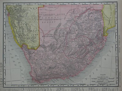
$6.00 Shipping Location: Greenacres, United States The map also locates diamond deposits north of Kimberley and labels missionary stations with the intitials "M.S.". Original large-format highly detailed ... more1890 antique engraved map of southern Africa, printed more than 125 years ago.
Buy It Now
$6.00 Shipping Location: Greenacres, United States It was published inCram's Modern Atlas: The New Unrivaled, George Franklin Cram, Chicago, 1902.
Buy It Now
$4.69 Shipping Location: Greenacres, United States Original 1906 Map SOUTH AFRICA Cape Town Natal Swaziland Walfish Bay Bushmen Handsome original antique color lithographed map of South Africa. Printed ... moremore than 100 years ago. The coverage area extends from the Kalahari Desert to the Cape of Good Hope. And details include cities, railroads, tribal kingdoms, colonial possessions, and natural features, with topography shown in relief. The map locates the British enclave of Walfish Bay in German Southwest Africa and it labels the tribal lands of the Khoma Bushmen. Colonial Bastards, Habobes, Africaner Namaquas, Obanen Bushmen, and others. Among the other specific named places and features are Natal. British Bechuanaland, Port Elizabeth, Lorenco Marquez, Orange River Colony, Transvaal, Durban, Swaziland, Portugese East Africa, Carnarvon, Malmesbury, Cape Town, Zululand, and many more. The scans below show some of the detail: The map was published by Rand McNally and is copyrighted © 1902 below the mileage scale. The image area measures 23.5 x 22 cm[9-1/4" x 12-1/2" Condition: It is in very good condition. Bright and clean, with no marks. Rips, or tears. There's a place-name index in the margin and a map of Oceania in similar style and format on the reverse side: Buy with confidence! This is an original. Authentic antique map, not a reproduction or modern reprint. And it is fully guaranteed to be genuine. It would make a handsome display in your den or office. It would also make a perfect gift, and we'll include our helpful framing tips for your reference. We are pleased to offer it with our unconditional. Money-back guarantee. SHIPPING: We gladly ship anywhere in the World. And we use sturdy, professional packing materials to assure safe delivery. The shipping charges are as follows: Within the United States. Including Alaska, Hawaii, and APO addresses: $4.59 To Canada or Mexico: $9.99 To all other international destinations: $14.29(These charges reflect recent increases made by the United States Postal Service for international delivery. We wi
$9.00 Shipping Location: Slovakia I believe in and encourage good communication! Original old German lithograph map/double page OLD BOOK PLATE. DO NOT DUPLICATE OR COPY! Condition can ... morebe see from the scan. (SEE PICTURE)! The print was folded inside the book and has original centrefold.
Buy It Now
$4.99 Shipping Location: Fairview, United States Atlas Classique Universel de Geographic Ancienne et Moderne (Paris, c. 1835), a copy of the atlas title page is included for authenticity. It is a small ... moreminiature map with V. Levasseur, Geog. printed in the lower margin, blank on the reverse.
$19.21 Shipping Location: SHREWSBURY, United Kingdom South Africa Map features - Mkuze a ubombo - Mozambique no 2632 Published 1994 Has been Folded - Approx 60x99 cm Used - some marks and wear creases from ... morebeing foldedDispatched with Royal Mail 2nd Class
Free Shipping Location: Monroe, United States ORIGINAL ANTIQUE 1897 COLOR MAP OFTHE SOUTH AFRICA. ORIGINAL 1897 ANTIQUE MATTHEWS NORTHUP DOUBLE PAGE ATLAS MAP OF SOUTH AFRICA. MAP HAS SCALES BELOW ... moreTITLE. GOOD CONDITION, DISCOLORATION, CENTER CREASE AS ISSUED.
$19.21 Shipping Location: SHREWSBURY, United Kingdom South Africa Map features - Lesotho Drakensberg no 2928 Published 1994 Has been Folded - Approx 89x59cm Used - some marks and wear creases from being ... morefoldedDispatched with Royal Mail 2nd Class
Buy It Now
Free Shipping Location: Sayville, United States
Buy It Now
$4.55 Shipping Location: Oakland, United States This antique map of South Africa was published in 1904 by Rand McNally & Co. It provides an insightful view of the country's geographical features and ... moretowns, making it an ideal addition to any collection of maps. The map measures 7x6 inches and is a valuable piece of history.
Buy It Now
$6.90 Shipping Location: Frankfort, United States TWO SIDED 13.5" x 10.5" MAP. THIS IS OVER 120 YRS OLD MAP.CONDITION OF PAPER IS NOT PERFECT.CHECK ALL PHOTOS CAREFULLY BEFORE PUCHASE.
$36.67 Shipping Location: HONITON, United Kingdom
Buy It Now
$6.80 Shipping Location: Solana Beach, United States Antique engraved and colored map of the Cape of Good Hope, South Africa. this map was issued for the Dutch edition of Provost’s Histoire des Voyages…. ... moreBeautifully rendered mountains and villages show the area in considerable detail.
Buy It Now
$6.95 Shipping Location: Dover, United States Issued 1912, Chicago by Rand McNally. Large, oversized early 20th century color lithographed map. This size allows for much more detail.

Buy It Now
Free Shipping Location: Netherlands ABOUT US VISIT OUR STORE SALES SPECIALS Antique Map-SOUTH AFRICA-MADAGASCAR-BONNE-Bonne-1780 Description: This attactive map originates from: Atlas de ... moretoutes les parties du Globe Terrestre. Published by M. Bonne in Paris, c. 1780. Artists and Engravers: Cartographer: Rigobert Bonne. 1727- 1795) was one of the most important cartographers of the late 18th century. He succeeded Jacques Nicolas Bellin as Royal Cartographer to France in the office of the Hydrographer at the French Depôt de la Marine. Engraved by Gaspard Andre. Subject: Map: Carte du Canal de Mosambique. Contenant L'Isle de Madagascar avec les les Cotes d'Afrique depuis le Cap de Bonne Esperance jusqu'a Melinde. Map of Mozambique Channel. Containing the Island of Madagascar with the coasts of Africa from Cape of Good Hope to Melinde. The inset map shows the Cape region in South Africa with False Bay, Robben Island etc. Condition: Fine. General age related toning and occasional light staining from handling as visible on image. Original fold lines. Size(in cm) The overall size is ca. 38 x 25 cm. The image size is ca. 32 x 22 cm. Size(in inch) The overall size is ca. 15 x 9.8 inch. The image size is ca. 12.6 x 8.7 inch. Medium: Copperplate engraving on verge type hand laid paper with watermark. Recent hand colouring. Location: A79-31 ThePrintsCollector Peter Cornelissen. Margo van Latum- van Dongen, Frank van Latum Zeeland- The Netherlands Phone: +31 654 21 23 78 Worldwide free shipping on all orders. We ship within one business day upon receipt of payment. We ship by Registered Mail. Insurance is included. We guarantee our items to be genuine original. Visit our Store: we would like to invite you to review similar items in our Store or to browse through all other items in our Store. We are confident that you will find very special unique antique maps and prints in our Store. It is our privilege to have you as a customer. We accept Paypal payments and payment by bank transfer. Combined auction/ buy it now orders are possible! We wil
Buy It Now
$5.00 Shipping Location: Canada ORIGIN OF THE MAP: "The World-Wide Atlas of Modern Geography" published by W. & A. K. Johnston Ltd., Edinburgh and London, UK.
Buy It Now
Free Shipping Location: Schertz, United States This Map was removed from an 1909 Rand McNally Atlas and is in good condition. This map is dated in fine print. This map in not new or in new condition. ... moreIt was printed in 1909. Study the photos carefully, this is the actual map you will receive.
Buy It Now
Free Shipping Location: Sayville, United States See photo's.
Buy It Now
Free Shipping Location: Schertz, United States This is an Authentic / Original Antique Atlas Map. It is not *NEW* or in *NEW* condition, it was printed in the year indicated. We sell only Old Antique ... moreMaps, not prints, copies or posters. See Photo for best description, this is the actual map you will receive.
Buy It Now
$6.90 Shipping Location: Jasper, United States Known for being one of the oldest and most respected publishing houses in Germany, the Bibliographisches Institut specialized in authoritative reference ... moreworks. The map's condition is as shown in the pictures.
Buy It Now
$4.55 Shipping Location: Oakland, United States This antique map of South Africa by Rand McNally & Co. is a perfect addition to any map or antique collection. The map was published in 1899 and features ... moredetailed cartography of the entire region. The intricate details and craftsmanship of the map make it a beautiful display piece.The map measures 7x6 and is in excellent shape for its age. It is a wonderful piece of history that provides a glimpse into the past. Whether you are a collector or just looking for a unique piece to add to your home, this antique map is sure to impress.
Buy It Now
Free Shipping Location: Sayville, United States
Buy It Now
$4.95 Shipping Location: Portland, United States
Buy It Now
$4.99 Shipping Location: Fairview, United States The pics are of the actual map. An Authentic Antique Map: Not a Modern Reproduction!
Buy It Now
Free Shipping Location: Sayville, United States
Buy It Now
$5.00 Shipping Location: Blue Bell, United States ORIGINAL ANTIQUE ATLAS MAP. CONDITION: MAP IS IN GOOD CONDITION. OVER 100 YEARS OLD! Over 100,000,000 served.
Buy It Now
Free Shipping Location: Augusta, United States "An Authentic Original Map Not A Reproduction".
Buy It Now
$13.80 Shipping Location: MANCHESTER, United Kingdom KAPLAND. NATAL, BURENREPUBLIKEN, und LUDERITZLAND Published Germany 1897 A steel engraved colour printed antique map of South Africa. A colour key identifies ... moreBritish. German and Portuguese territories. Dated in the plate Fine. Unmarked condition. Approx. 14" x 9" 360mm x 230mm) map area only with good margins beyond. Please scroll right down for close up image. A GENUINE ANTIQUE MAP GUARANTEED OVER 100 YEARS OLD FROM LINDISFARNE PRINTS We do not deal in reproductions. Facsimiles or copies of any kind. SHIPPING TWO ITEMS WILL BE COMBINED. WITH ONE SHIPPING CHARGE. THREE ITEMS OR MORE SHIPPED FREE OF CHARGE. WORLDWIDE! Why not browse our ebaystore? THANKS FOR YOUR INTEREST! Be sure to add me to your! Check out my! MI612. Powered by g.RcmdId ViewItemDescV4,RlogId p4%60bo7%60jtb9%3Fuk%601d72f%2Bjw%60hquvg%3Eg-141337db6dc-0x100-
Buy It Now
$17.60 Shipping Location: Torrance, United States Illustrated by Chris Robitaille. Zimbabwe Map. South Africa Map.
Buy It Now
$6.95 Shipping Location: Dover, United States Cape of Good Hope, Natal &c. Issued c. 1856-72, London by Edward Weller for the Weekly Dispatch Atlas. Mid 19th century lithographed map in two sheets ... more(as issued) with original outline hand color.
Buy It Now
$6.95 Shipping Location: Dover, United States Issued 1746, Paris for J.N. Bellin. Attractive mid 18th century engraved map with appealing hand color. Any age flaws minor and easy to overlook or forgive.
Buy It Now
Free Shipping Location: Schertz, United States This is an Authentic / Original Antique Atlas Map. It is not *NEW* or in *NEW* condition, it was printed in the year indicated. We sell only Old Antique ... moreMaps, not prints, copies or posters. See Photo for best description, this is the actual map you will receive.
Buy It Now
Free Shipping Location: North Wales, United States 1895 ANTIQUE "THE TIMES" ATLAS MAP OF SOUTH AFRICA-EXCELLENT DETAIL ORIGINAL ANTIQUE ATLAS MAP PLEASE SEE PHOTOS AS PART OF THE DESCRIPTION CONDITION: ... moreMAP IS IN GOOD CONDITION. SIZE: APPROXIMATELY 10.5" X 16" SHIPPING: U.S. FIRST CLASS RATE - $6.00 - ANY ITEM WHICH SELLS FOR OVER $100 WILL REQUIRE INSURANCE WE COMBINE SHIPPING FOR MULTIPLE WINS. THANK YOU FOR YOUR INTEREST IN OUR AUCTIONS!.
Buy It Now
Free Shipping Location: Sayville, United States
Buy It Now
$7.00 Shipping Location: Lithuania Map of Location map of Cape Town. Print size 6x13cm.
Buy It Now
Free Shipping Location: Eugene, United States This is the original antique 1855 hand colored map of SOUTHERN AFRICA published by JOSEPH HUTCHINS COLTON in his original 1855 ATLAS OF THE WORLD. This ... moremap includes SOUTH AFRICA long before union: CAPE COLONY, BRITISH KAFRARIA, THE TRANSVAAL REPUBLIC, NATAL and ZULU COUNTRY. MADAGASCAR and MOZAMBIQUE are delineated.
Buy It Now
$4.13 Shipping Location: Miami, United States A vintage Colorprint General Atlas of the World. Has pages showing different parts of the world and a page showing the flags of the nations. In good condition ... morebut the cover is ripped at the bidding. Please see pictures and let me know if you have any questions! Posted with
Buy It Now
$13.80 Shipping Location: MANCHESTER, United Kingdom This interesting map is an original antique which is over 120 years old.
Buy It Now
$6.95 Shipping Location: Dover, United States Issued 1748, Paris by Bellin. Mid 18th century engraved coastal chart with lovely hand color.
$6.00 Shipping Location: Corunna, United States This map is from A New General Atlas Exhibiting The Five Great Divisions of the Globe drawn and engraved by M. Malte-Brun. Atlas was published by Grigg ... more& Elliot Philadelphia 1832. This is an original 192 year old map, not a copy or reprint.
Buy It Now
Free Shipping Location: Sayville, United States Has a table of Colonial occupation. A rare and distinctive map that was drawn between the World Wars.
Buy It Now
$4.95 Shipping Location: Dover, United States (Map, South Africa, Indian Ocean, South Atlantic Ocean, Cape Town, Cape Colony, Orange Free State ). Late 19th century lithographed map with strong original ... morehand color. South Africa.
Buy It Now
Free Shipping Location: Schertz, United States This Map was removed from a 1952 Picture Map Geography of AFRICA and is in very good condition. The map is not " new " or in " new " condition, it was ... moreprinted in 1952. The map is not dated. Study the photos carefully, this is the actual map you will receive.
Buy It Now
$4.13 Shipping Location: Manville, United States Original print made in Germany. Condition: Very good. 15 cm x 25 cm approx.
Buy It Now
$4.00 Shipping Location: Chehalis, United States 10.25 x 11 inch map printed on thin, tissue-like paper, titled "S.A.G.M. Stations in South Africa" and published by the South Africa General Mission in ... moreBrooklyn, New York. Undated; our best guess is ca. 1915-20. Nice condition, with folding creases and a slightly soapy odor.
$25.00 Shipping Location: Perugia, Italy The Atlas Universel was the crowning glory of the Robert de Vaugondy firm's atlas production. To minimize his fiscal risk, Boudet sold the atlas first ... moreby subscription using a large prospectus, receiving in the process over 1100 pre-orders.
Buy It Now
Free Shipping Location: Schertz, United States This is an Authentic / Original Antique Atlas Map. It is not *NEW* or in *NEW* condition, it was printed in the year indicated. We sell only Old Antique ... moreMaps, not prints, copies or posters. See Photo for best description, this is the actual map you will receive.
Buy It Now
Free Shipping Location: Rochester, United States Great little 123 page travel guide in excellent.
Buy It Now
Free Shipping Location: Monroe, United States ORIGINAL LARGE 1898 DOUBLE PAGE MAP OF THE WORLD. INTERESTING AND BEAUTIFULLY COLORED MAP OF THE WORLD WITH CONTINENTS, CITIES, CURRENTS, WATERWAYS AND ... moreLAND SURFACE AMOUNT FOR EASTERN AND WESTERN HEMISPHERES.
Buy It Now
Free Shipping Location: Monroe, United States RARE ORIGINAL 1853 ANTIQUE HAND-COLORED MAP OF AFRICA. RARE ORIGINAL 1852 ANTIQUE HAND-COLORED MAP OF AFRICA. DATED 1852 AT BOTTOM.
Buy It Now
Free Shipping Location: Augusta, United States "An Authentic Original Map Not A Reproduction".
$5.99 Shipping Location: Fall River, United States Whether it is a book or collectable item.
Buy It Now
$5.00 Shipping Location: Wilmington, United States Physical Africa. Original Atlas Map not a modern reproduction or copy.
$20.78 Shipping Location: DAVENTRY, United Kingdom

Buy It Now
$4.13 Shipping Location: Bolivia, United States 1899 ORIGINAL ANTIQUE MAP OF SOUTH AFRICA BOER REPUBLICS ORANGE TRANSVAAL This original antique map gives you an opportunity to examine in exquisite detail ... morea piece of history. If you are interested in the past of this country and its people or have a desire to study where your family may have come from. Then this map gives you a rare look as the area was about 100 years ago. Once matted and framed, this map would make a perfect gift for a family member or friend they'll cherish forever. Origin of the map: Andree's Allgemeiner Handatlas" Published in Leipzig, Germany by Velhagen& Klasing. Date of issue: 1899 Size: The sheet measures 17 1/4" x 11" 44 x 28 cm) S/H: The map will be shipped by Air Mail. The shipping charge is: USA- 7.50. World/Canada- 8.50. The price includes the insurance and a strong, cardboard tube with plastic plugs. Attention! There is no additional shipping charge for multiple purchases! Pay me securely with any major credit card through PayPal! Payment methods: US/Canada Buyers: Paypal. International Buyers: Paypal. Click Here. Double your traffic. Get Vendio Gallery- Now FREE! RcmdId ViewItemDescV4,RlogId p4%60bo7%60jtb9%3Fuk.rp*4a24%60%3C%3E-13f2242d433-0xfb-
Buy It Now
Free Shipping Location: Iowa City, United States It was engraved and printed by theL.L. Indigenous Tribes are also located. 1908 (Dated) Genuine Engraved Color Map. This is an authentic 1908 map--NOT ... morea recent reproduction. This is a genuine 1908 map--NOT a recent reproduction.
Buy It Now
$5.00 Shipping Location: Canada DATE OF ISSUE: 1907. ORIGIN OF THE MAP: "The Handy Royal Atlas of Modern Geography", published in Edinburgh/London by W. & A. K. Johnston.
Buy It Now
$13.80 Shipping Location: MANCHESTER, United Kingdom This original antique map is from The Handy Royal Atlas of Modern Geography by Alexander Keith Johnston, published by W. & A.K. Johnston, Edinburgh & ... moreLondon, 1884. This interesting map is an original antique which is over 140 years old.
Buy It Now
Free Shipping Location: Netherlands Description: While these maps by Van Schley after Bellin were initially made for 'Histoire Generale des Voyages' (Paris 1746-1759), this is from the 1758 ... moreDutch edition of that work published by Arkstee & Merkus. Artists and Engravers: Made by 'Jakob van Schley' after 'Jacques Nicolas Bellin'. Jakob van der Schley (1715-1779) was a Dutch draughtsman and engraver, who studied under Bernard Picart. Jacques-Nicolas Bellin (1703-1772) was a French hydrographer, geographer and member of The Philosophes. His career, spanning over 50 years, caused an enormous outpt in maps, particular of maritime interest.
|
|
|
|
ANTIQUE 1877 AFRICA MAP LIBERIA SIERRA LEONE EGYPT SOUTH CAPE COLONY BARBARY NR
Click Here. Double your traffic. Get Vendio Gallery- Now FREE! Superb. Very fine, antique 1877 handcolored map, titled Map of Africa, with inset maps of Egypt and Liberia and Sierra Leona, the maps are very detailed, the main Africa map is also fascianting, a gorgeous, detailed period map, much has changed. The map is in very fine condition, and would frame and display beautifully. The gorgeous handcoloring is period to the map. The size of the map is 9.5" by 12" Rare. Winning bidder pays $3.25 shipping domestic, more foreign. Payment I accept the following forms of payment: PayPal Click to View Image Album Shipping& Handling US Shipping. $3.25 USPS First-Class Mail® International Shipping. $9.00 USPS First-Class Mail International FREE scheduling. Supersized images and templates. Get Vendio Sales Manager. FREE scheduling. ... moreSupersized images and templates. Get Vendio Sales Manager.
|
|
|
1897 LARGE ANTIQUE VICTORIAN MAP ~ SOUTH AFRICA ~ CAPE COLONY TRANSVAAL
Beautiful large antique map on quality paper E XCELLENT condition and rescued from a disbound Atlas: BLACK'S GENERAL ATLAS OF THE WORLD 1890 THIS SUPERB VICTORIAN MAP IS AN ORIGINAL- APPROXIMATELY 125 YEARS OLD AND NOT A REPRODUCTION*FEATURES SUPERB DETAIL* Published by Adam& Charles Black. London This single fold sheet measures approximately 24 inches by 17 1/2 inches(610mm x 445mm) Printed on quality paper EXCELLENT CONDITION ~ MINOR HANDLING& AGE MARKS AT EXTREMITIES Please email with any questions regarding this item(Black's General Atlas 1890) BEST OFFERS PLEASE FOR A QUICK SALE AT A FAIR PRICE If you like the item. But do not like the price, then make a realistic offer to us using the MAKE OFFER BUTTON
|
|
|
Old Map AFRICA, SOUTH OF THE EQUATOR ~ From Universal Atlas 1893
Maps are becoming increasingly popular for interior design purposes- vintage and retro- as well as obviously the purpose for which they were designed- Please Check out my! for other maps and retro collectables THIS ITEM IS FREE UK POSTAGE- INTERNATIONAL PRICES ARE AT THE BOTTOM OF DESCRIPTION This Auction is for a VINTAGE MAP 1893 TAKEN FROM THE UNIVERSAL ATLAS Published for The Atlas Publishing Company Limited By Cassell& Company. Limited 1893 Depicting: AFRICA. SOUTH OF THE EQUATOR Pages 109& 110 From the Atlas(Single Sheet folded in half) Naturally it comes in used condition with some minor foxing and browning The full sheet once opened out measures approx: 21" x 16" 53 cm x 41 cm) THIS AUCTION IS FOR ONE SHEET AS SHOWN IN THE FIRST PHOTO However. The photos on the listing do show the front cover of the original Atlas ... morewhich is the source of the map and a picture of the title page of the book to confirm authenticity On the bottom of each map is printed: The Atlas Publishing Company Limited- Printed in Leipzig This map will be rolled up in a tube shape for ease of transit I WILL BE LISTING OTHER SIMILAR ITEMS AND AM WILLING TO COMBINE POSTAGE You can purchase upto 5 maps and you only be charged 1 x postage(or free if within UK) In order to take advantage of the combined postage offer PLEASE ADD ITEMS TO YOUR EBAY SHOPPING CART TO PURCHASE MULTIPLE ITEMS WITH A SINGLE PAYMENT. ANY QUESTIONS PLEASE EMAIL I WILL ANSWER. Please do not leave until the last minute of the auction as I cannot guarantee to answer straight away. But always within the day. PAYMENT FOR THIS ITEM MUST BE MADE WITHIN 3 DAYS OF THE END OF THE AUCTION. IF THIS POSES A PROBLEM TO YOU DUE TO HOLIDAY ETC. PLEASE EMAIL ME BEFORE BIDDING SO THAT I AM AWARE. Thank you Will accept cheque. Postal order or Paypal from UK bidders. International bidders PAYPAL ONLY. Goods sent immediately upon clearance of payment. Thank you. Check out my other items! Be sure to add me to your favourites list! OVER THE NEXT FEW WEEKS I WILL BE LISTING MA
|
|
|
Original Antiquarian 1889 Map of Cape Colony & South Africa, Victorian Geography
Vintage Folding Map Publisher: W& R Chambers. Printed by W& A K Johnson Published- 1889 Area Covered- As Per Title Description- Paper map in colour. Condition- Rough on one edge. Map itself in Vg condition. Centre fold. Size- 10.75" x 8.5" The outer border adding around an inch to each side. Ex Chambers's Encyclopaedia. 1889- One of a number of similar Items I am selling. Postage combined when taking more than one item where possible. If Purchasing Multiple items please await an invoice BEFORE paying. Heavy items may not be able to be sent to PO Boxes overseas. Contact me for more details- Overseas Bidders* No cheques please unless drawn on a UK bank. Overseas transactions to be paid with Paypal. NO Foreign Currency, thanks*All Bidders* Please note that items are sent to the address as stated on your invoice unless I ... moream imformed otherwise in A SEPARATE EMAIL VIA EBAY. I reserve the right to charge an additional fee for higher value items to cover the cost of a'signed for' service. Postage is combined when more than one item is purchased where possible. MY GRADINGS New: A new book. Never used. Fine(F) Should have no flaws, a perfect copy of a used book. Mint: Another term for Fine. As New(AN) Although a used book. It should appear unread with no flaws, just as when it was sold new. Near Fine(NF) May show a small flaw. Such as shelf wear, but nearly perfect and unread. Very Good(VG) The broadest category for used books. This describes any average used book. May have small flaws, and has probably been read, but should appear overall clean and attractive. Good(G) Will probably have significant wear or damage. Although is still intact. Suitable for reading, but not necessarily a good gift copy. The old saying in bookselling is"good ain't good. Fair: Another term for Poor or Reading Copy: Heavily worn or damaged. A poor book will be readable but not attractive. May have the odd page missing, but this will be noted on the relativ
|
|
|
1902 VICTORIAN MAP ~ SOUTH AFRICA CAPE COLONY ELECTORAL DIVISIONS NATAL WALFISCH
AN ORIGINAL VICTORIAN MAP RESCUED FROM A DISBOUND ATLAS 1902 THIS IS AN ORIGINAL MAP APPROXIMATELY 113 YEARS OLD AND NOT A LATER REPRODUCTION Approximate size ~ 11 inches by 8 1/2 inches(280mm x 215mm) Condition ~ Very GOOD condition Please view image to see any age/handling marks. Stains or spotting ~ if in any doubt please message for a condition report on this specific print There will be another map on the reverse of the print BEST OFFERS PLEASE FOR A QUICK SALE AT A FAIR PRICE If you like the item. But do not like the price, then make a realistic offer to us using the MAKE OFFER BUTTON WR(ww1902) Powered by.RcmdId ViewItemDescV4,RlogId p4%60bo7%60jtb9%3Fuk.rp*3A%3Cd%3Ff6%3E-146f5accedc-0x10e-
|
|
|
AFRICA South of the Equator Showing European Possessions - Antique Map 1899
AFRICA South of the Equator Showing European Possessions- Antique Map 1899 Print Description: AFRICA South of the Equator Showing European Possessions- Antique Map 1899 Size: The Size of the print/map not including margins is approximately 14.25x9.25 inches. Cartographer: Provenance: Published at the office of'The Times' Printing House Square, London 1899. Taken From'The Times Atlas' Authenticity: This is a guaranteed genuine antique print. We do not deal in facsimiles or reproductions of any kind. Condition: Very Good; Suitable for framing. We grade all prints individually into four levels- Excellent. Very Good, Good, and Fair. Generally prints in excellent condition are free from foxing, rips,tears or folds. Very Good prints may have some minor foxing or spotting, however this will mainly be confined to the margins. Good ... moreand fair may have more general foxing. We try to represent all the images to the best of our ability, and we ask you to check the above scans before purchasing Payment: PayPal is our only accepted method of payment. We accept PayPal payments from buyers all over the world. PayPal is the safest. Easiest and quickest way to make online purchases. If you are purchasing multiple items, please add all the items to your shopping basket before proceeding to the checkout. If you do not already have a PayPal account, simply click on the'Buy It Now' button and follow the eBay checkout instructions. You will then be able to enter your card details in order to pay via PayPal even if you do not already have a PayPal account. Paying via PayPal also ensures that your purchase is fully protected and guaranteed. Returns Policy: If for any reason you are not satisfied with your order we will gladly accept a return for refund or credit. If you wish to return goods you MUST inform us within 14 days of receipt of your order. Please do not return goods without prior consent. All returns must be received in perfect re-saleable condition in order for refunds to be granted. If the item you retur
|
|
|
SOUTH AFRICA Showing British, German, Portuguese Posessions - Antique Map 1899
SOUTH AFRICA Showing British. German, Portuguese Posessions- Antique Map 1899 Print Description: SOUTH AFRICA Showing British. German, Portuguese Posessions- Antique Map 1899 Size: The Size of the print/map not including margins is approximately 14.25x9.25 inches. Cartographer: Provenance: Published at the office of'The Times' Printing House Square, London 1899. Taken From'The Times Atlas' Authenticity: This is a guaranteed genuine antique print. We do not deal in facsimiles or reproductions of any kind. Condition: Very Good; Suitable for framing. We grade all prints individually into four levels- Excellent. Very Good, Good, and Fair. Generally prints in excellent condition are free from foxing, rips,tears or folds. Very Good prints may have some minor foxing or spotting, however this will mainly be confined to the margins. ... moreGood and fair may have more general foxing. We try to represent all the images to the best of our ability, and we ask you to check the above scans before purchasing Payment: PayPal is our only accepted method of payment. We accept PayPal payments from buyers all over the world. PayPal is the safest. Easiest and quickest way to make online purchases. If you are purchasing multiple items, please add all the items to your shopping basket before proceeding to the checkout. If you do not already have a PayPal account, simply click on the'Buy It Now' button and follow the eBay checkout instructions. You will then be able to enter your card details in order to pay via PayPal even if you do not already have a PayPal account. Paying via PayPal also ensures that your purchase is fully protected and guaranteed. Returns Policy: If for any reason you are not satisfied with your order we will gladly accept a return for refund or credit. If you wish to return goods you MUST inform us within 14 days of receipt of your order. Please do not return goods without prior consent. All returns must be received in perfect re-saleable condition in order for refunds to be granted. If the item you
|
|
|
Map.. South Africa ///1930/// antique print
Antique map from"Stieler's Handatlas" 1930 Size of the print with margins: 15.3 x 18,9 inches 39 x 48cm This is not a recent copy or modern reproduction I combine shipping on multiple sales Buyers must first add items to their eBay Shopping Cart to purchase multiple items with a single payment Powered by The free listing tool. List your items fast and easy and manage your active items.
|
|
|
1893 ANTIQUE MAP ~ SOUTH AFRICA ENVIRONS CAPE TOWN PORT ELIZABETH NATAL ZULULAND
A beautiful antique VICTORIAN map on fine quality paper GOOD condition and rescued from a disbound atlas: BACON'S NEW GENERAL ATLAS of the WORLD Map produced& printed by: Bacon's Geographical Establishment in 1893. SUPERB DETAIL ~ THIS MAP IS AN ORIGINAL OVER 120 YEARS OLD AND NOT A REPRODUCTION This FOLD-OUT map measures approximately 20 inches by 13 inches(510mm x 335mm) Printed on fine quality paper& Free from any text on the reverse A superb map in good condition ~ Minor handling/age related marks at the extremities Please message with any questions regarding this item. BEST OFFERS PLEASE FOR A QUICK SALE AT A FAIR PRICE If you like the item. But do not like the price, then make a realistic offer to us using the MAKE OFFER BUTTON. Powered by
|
|
|
ANTIQUE MAP LANDKARTE SOUTH AFRICA BARBARY ALGIER HAND COLOURED HISTORY 1834
Antique Hand coloured Map showing South Africa or Barbary Algier published by Baldwin& Cradock 1st Sept 1834 Size: 41 x 34.5 cm Will be posted in protective packaging Postage is the basic price but may increase depending on what the final bid is on these photos as Royal Mail only covers them up the value of £20.00. Please wait for invoice before making payment. The buyer will be responsible for any customs charges incurred. Please note that I cannot guarantee that this item comes from a smoke or pet free home
|
|
|
1892 LARGE MAP ~ NORTH WEST AFRICA MOROCCO ALGERIA TUNIS ~ SOUTH AFRICA NATAL
A superbly detailed antique map on a single sheet Produced by W& A K Johnston for The Cosmographic Atlas 1892 This scarce map is an original over 120 years old This large single page measures 18 1/2 inches x 14 inches(470mm x 355mm) CONDITION: Please view images to see signs of age/handling There will be another map on the reverse Please message with any questions regarding this item. BEST OFFERS PLEASE FOR A QUICK SALE AT A FAIR PRICE If you like the item. But do not like the price, then make a realistic offer to us using the MAKE OFFER BUTTON. Powered by
|
|
|
1896 LARGE VICTORIAN MAP ~ NORTH WEST AFRICA & SOUTH AFRICA WITH ELECTORAL DIV
Beautiful ANTIQUE MAP on quality paper EXCELLENT condition and rescued from a disbound KEITH JOHNSTON'S HANDY ROYAL ATLAS 1896 THIS MAP IS AN ORIGINAL- OVER 115 YEARS OLD AND NOT A REPRODUCTION THIS MAP WAS PRODUCED IN 1896 PRINTED ON THICK PAPER WITH VIBRANT OUTLINE COLOUR"The Handy Royal Atlas Of Modern Geography Exhibiting The Present Condition Of Geographical Discovery And Research In The Several Countries. Empires And States Of The World by Keith Alexander Johnston. This DOUBLE PAGE FOLD-OUT map measures approximately 18 1/2 inches by 14 1/2 inches(470mm x 370mm) PLEASE VIEW IMAGE TO SEE HANDLING& AGE RELATED MARKS Printed on quality paper The map is free from any text or image on the reverse A superb map in excellent condition Please message with any questions regarding this item(Handy Royal Atlas 1896) BEST OFFERS PLEASE ... moreFOR A QUICK SALE AT A FAIR PRICE If you like the item. But do not like the price, then make a realistic offer to us using the MAKE OFFER BUTTON Powered by ag6 2.RcmdId ViewItemDescV4,RlogId p4%60bo7%60jtb9%3Fuk.rp73%28c%3Eag6%3E2-148b9560030-0x113-
|
|
|
STIELER'S HAND ATLAS #71 SOUTH AFRICA & MADAGASKAR
Purchased at auction. This map comes from the book. STIELER'S HAND ATLAS. This is Plate# 71. SUD AFRIKA& MADAGASKAR. SOUTH AFRICA& MADAGASKAR) GOTHA: JUSTUS PERTHES. 1876. Map( page) measures about 18-1/4" x 15-1/8" There is a wide margin all the way around which will make it perfect to frame. I removed the map prior to listing and will continue to list the rest as time goes by. If there is a certain map that you would like let me know and I will list it asap. Otherwise it will be in order of the book. Pages are discolored but no other problems unless stated otherwise. Crease in the center where it was attached to the book. ALL LISTINGS WILL BE SOLD AS IS. IF YOU NEED MORE INFO ASK! Everyone has different opinions as to what is acceptable and what is not. Or what is considered a miniature or color shade. Please ask questions! ... moreAlways glad to combine purchases to save you $$ So Check out my! Please do not hold me responsible for Loss or damage caused by the Post Office. I wrap all Breakable items with Bubble Wrap and Pack in Styrofoam Peanuts. If you would like it packed a different way please ask.I am happy to pack which ever way you would like. Want your Item shipped to a different address. And Gift Wrapped? No Problem! Visit my: Questions? Please ask! Be sure to add me to your! Almost all of my listings were purchased at auction. Many will need cleaned. The less I have to do to the item the cheaper I can list it. I list them by what I see. I am not a expert on antique or vintage items will be glad to send extra pictures to your e-mail address I leave feedback on my sales after the buyer has received the item and by leaving feedback first. This lets me know that you have received the package and are happy with your purchase If for some reason there is a problem. Please allow me the opportunity to correct it if possible, before leaving neutral or negative feedback. I try to be fair with all my customers and hope to get the same courtesy from you. S&H charge shown is a E
|
|
|
c1880 VICTORIAN MAP ~ SOUTH AFRICA CAPE TOWN CITY PLAN GRAHAM-TOWN CAPE ENVIRONS
AN ORIGINAL ANTIQUE MAP This print came from a large antique auction lot of Georgian. Early Victorian and later maps Date if known or approximate date as per listing title The size of each print varies so please check against the scale shown which is 2 cm apart This is a genuine antique and not a modern copy*CONDITION* PLEASE VIEW IMAGES TO SEE ANY HANDLING/AGE MARKS/REPAIRS/DAMAGE/EXTENT OF MARGINS& TRIMMING etc* Please message with any questions regarding this item* BEST OFFERS PLEASE FOR A QUICK SALE AT A FAIR PRICE If you like the item. But do not like the price then make a realistic offer to us using the MAKE OFFER BUTTON* GPM Powered by
|
|
|
1892 VICTORIAN MAP ~ SOUTH AFRICA ~ MADAGASCAR CAPE COLONY CONGO
Beautiful old VICTORIAN MAP on quality paper very good condition and rescued from a disbound Atlas 1892 First edition: The World Wide Atlas W& A K Johnston THIS MAP IS AN ORIGINAL- APPROXIMATLELY OVER 110 YEARS OLD AND NOT A REPRODUCTION This single page measures approximately 11 1/2 inches by 9 inches(293mm x 292mm) Printed on quality paper The map will have another image on the reverse ~ HAND COLOURED COUNTRY/COUNTY BORDERS ~ FREE FROM ANY FOLDS. CREASES OR TEARS A superb map in very good condition MINOR HANDLING/AGE MARKS AT EXTREMITIES Please email with any questions regarding this item(World Wide Atlas 1892)REPEAT BEST OFFERS PLEASE FOR A QUICK SALE AT A FAIR PRICE If you like the item. But do not like the price, then make a realistic offer to us using the MAKE OFFER BUTTON Posted with the
|
|
|
1899 LARGE VICTORIAN MAP ~ SOUTH AFRICA BRITISH COMPANY PORT ELIZABETH CAPE TOWN
A beautiful antique map on fine quality paper EXCELLENT condition and rescued from a disbound atlas: BACON'S POPULAR ATLAS of the WORLD 1899 Map produced& printed by: Bacon's Geographical Establishment SUPERB DETAIL THIS VICTORIAN MAP IS AN ORIGINAL OVER 110 YEARS OLD AND NOT A REPRODUCTION This FOLD-OUT map including borders measures approximately 19 inches by 13 inches(485mm x 335mm) ~ Printed on fine quality paper Free from any text on the reverse A superb map in excellent condition ~ Minor handling/age related marks at the extremities ~ Please email with any questions regarding this item(Bacon's Popular Atlas of the World) BEST OFFERS PLEASE FOR A QUICK SALE AT A FAIR PRICE If you like the item. But do not like the price, then make a realistic offer to us using the MAKE OFFER BUTTON
|
|
 |