|
|
Order by: Available to: This site contains affiliate links for which I may be compensated
|
Buy It Now
$6.95 Shipping Location: Dover, United States Issued 1738, London. Engraved by J. Blundell. Syria after ye Death of Alexander the Great. Attractive early 18th century engraved map, with lovely hand ... morecolor. Clean condition, original horizontal fold line as issued.

Buy It Now
Free Shipping Location: Netherlands ABOUT US VISIT OUR STORE SALES SPECIALS Antique Map-JUDEA-ISRAEL-PALESTINE-HOLY LAND-Vaugondy-1785 Description: This map originates from an Atlas by Didier ... moreRobert de Vaugondy or his successor De Lamarche. Published ca. 1785. Artists and Engravers: Gilles Robert de Vaugondy(1688�1766) Also known as Le Sieur or Monsieur Robert, and his son, Didier Robert de Vaugondy(c.1723�1786) were leading mapmakers in France during the 18th century. Subject: Map: Judee ou Terre Sainte. Map of Judea/ Israel or the Holy Land) Condition: Good. General age related toning and light staining. Original fold line from binding as issued. Please study scan carefully. Size(in cm) The overall size is ca. 28 x 22 cm. The image size is ca. 15 x 19 cm. Size(in inch) The overall size is ca. 11 x 8.7 inch. The image size is ca. 5.9 x 7.5 inch. Medium: Engraving and etching on a verge type hand laid paper. Outline hand colour. Location: A221-12 ThePrintsCollector Peter Cornelissen. Margo van Latum- van Dongen, Frank van Latum Zeeland- The Netherlands Phone: +31 654 21 23 78 Worldwide free shipping on all orders. We ship within one business day upon receipt of payment. We ship by Registered Mail. Insurance is included. We guarantee our items to be genuine original. Visit our Store: we would like to invite you to review similar items in our Store or to browse through all other items in our Store. We are confident that you will find very special unique antique maps and prints in our Store. It is our privilege to have you as a customer. We accept Paypal payments and payment by bank transfer. Combined auction/ buy it now orders are possible! We will send a Paypal invoice on request! THE PRINTSCOLLECTOR GUARANTEES ITEMS SOLD THROUGH EBAY ARE GENUINE ORIGINAL ANTIQUE PRINTS IN THE CONDITION/TECHNIC AS DESCRIBED. ITEMS CAN BE RETURNED WITHIN 7 DAYS. Powered by
Buy It Now
$6.95 Shipping Location: Dover, United States Issued 1768, London. Engraved by W.H. Toms. Original center fold as issued. Mid-18th century engraved map with attractive hand color. Any age flaws mostly ... moreminor and easy to overlook or forgive.
Buy It Now
$6.95 Shipping Location: Dover, United States Issued 1852, Paris by Basset. Map by V. Levasseur. Engraved by Ch. Uncommon decorative mid 19th century engraved map with original outline hand color.

Buy It Now
Free Shipping Location: De Fryske Marren - Langweer, Netherlands iscra antique maps& prints'Het Beloofde Landt Canaan Door wandelt onsen Salichmaaker. Description: Attractive and very decorative antique map ... moreof the Promised Land.This map is the first state with Cornelis Danckerts privilege. There is Dutch text on verso. Publication/maker: Cornelis Danckerts/ Albert Schut Printing date: 1710 Technic: Copper engraving with later colouring. Size: The overall size is 20.5 x 16 inch.The image size is 19,5 x 13,5 inch. Condition: Fine; folds as issued A Certificate of Authenticity will be added! THERE IS FREE SHIPPING FOR ADDITIONAL ITEMS! Thanks for looking! ISCRA STORE* We accept Paypal payments and Bank transfer payments! Combined orders possibl e! Insurance included! Because of different configurations of monitors colours can appear a bit different on you screen. The sizes of the pictures are(most of the time) not the real print size. The real sizes are noted in the description area. Import duties. Taxes and charges are not included in the item price or shipping cost and are buyer's responsibility. WE GUARANTEE ITEMS SOLD ARE IN THE CONDITION DESCRIBED. ITEMS CAN BE RETURNED WITHIN 14 DAYS after delivery or pick-up date Powered by The free listing tool. List your items fast and easy and manage your active items.
Buy It Now
$11.00 Shipping Location: Israel Color map (double sided). One side features a large Tourist Map in color subtitled The Hashemite Kingdom of Jordan. Inset is a small map of International ... moreBoundaries for countries in the region showing Turkey, Syria, Lebanon, Jordan, Egypt, Saudi Arabia, Iraq and Iran.
Buy It Now
$15.00 Shipping Location: Israel Ancient Palestine ( Biblical Judea and Samaria). around 1860. The London Series. A nice and unusual coloured old map of. The map can be folded into a.
Buy It Now
$30.00 Shipping Location: Paris VI, France Edition : edited by Pierre Mortier (1661-1711), Amsterdam, c. 1700, XVIIIe Century. Condition : very good condition, in antique colors, well engraved, ... morevery large margins.

Buy It Now
$8.00 Shipping Location: Bulgaria Normal 0 21 false false false MicrosoftInternetExplorer4 1890 JERUSALEM City Plan ISRAEL Palestine Holy Land Antique Map D E S C R I P T I O N Normal ... more0 21 false false false MicrosoftInternetExplorer4 THERE ARE NOT ANY SPOTS OR STAINS ON THE PRINT! THIS APPEARS DUE TO THE SCANNER. S OME PART OF THE IMAGE MAY BE CUT DURING THE SCANNING! Normal 0 21 false false false MicrosoftInternetExplorer4 Normal 0 21 false false false MicrosoftInternetExplorer4 Due to the scanner the image is more yellow than in reality. There is a light stripe in the middle of the page. Caused by the scanner. In reality there is a fold in the center. This is an original old German map– a double page book plate. This original. Authentic antique map was a part of old German book. This is NOT a modern reproduction! VERY DECORATIVE. PERFECT FOR FRAMING! The map is printed in Leipzig. Germany, by the Bibliographishes Institut in 1890 SIZE– apr. 12’ 10’ inches– perfect for framing. There is a fold in the center– the print was folded inside the book. The image presents the area of the print. Which will be visible when it is framed. ABOUT THE CONDITION– please check the scan arefully. SHIPPING We use a tube in order to protect the prints. We ship registered only. For USA and Canada– registered with priority. FEES- $ 8 for 1-3 prints in a tube. $ 19 for up to 20 prints. PAYMENTS Please pay by PAYPAL in a reasonable time after your purchase. We hate to open“non paid item” disputes or cases. But life is not only pleasure L. PLEASE NOTE! After reading this description. If there are any questions. Please ask us BEFORE bidding! If there is a problem with your item before or after it’s receiving. Please contact us ASAP. We’ll give our best to resolve the problem in a friendly manner.
Buy It Now
$6.80 Shipping Location: Eagle, United States Presented is an authentic 150 year old map taken from a disbound atlas published by S. Augustus Mitchell in 1865. Original hand color. This map is very ... morefinely engraved and features Mitchell's well-known decorative border.
Buy It Now
$4.99 Shipping Location: Fairview, United States The Bible Atlas of Sacred Geography Delineated (London: Baldwin & Cradock, 1831). A facsimile copy of the title page is included for authenticity. An ... moreAuthentic Antique Map: Not a Modern Reproduction.
Buy It Now
$30.00 Shipping Location: Paris VI, France Nice antique lithographic view of Hebron in Palestinia, from a painting of the famous orientalist artist David Roberts (1796-1864), a friend of the painter ... moreTurner. Title of the view.

Buy It Now
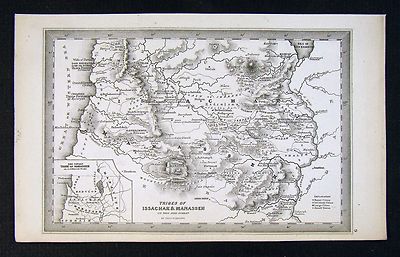
$15.00 Shipping Location: Brooklyn, United States 1823 Manuscript Map of Palestine or Holy Land in Antiquity WE SELL ONLY ORIGINAL ANTIQUE MAPS- NOT REPRODUCTIONS Title: Palestina Antiqua. Description: ... moreAn unusual and beautiful 1823 manuscript map of the Palestine. Israel, or the Holy Land in Biblical times. The map generally follows the historical atlas work of the English cartographer James Wyld however is a fully independent and unique hand rendered production. The manuscript geographical data and detail throughout is altogether outstanding and completed in a fine hand adept at decorative text and the rendering of rivers and mountains. Centered on the Jordan River, this map covers the region between modern day Gaza and Lebanon and from the Mediterranean eastward roughly to modern day Amman Jordan. The map is divided and color coded according to the lands given to the tribes of Israel. In the upper right the ten cities of the Decapolis– the Roman era political entity governing the region– are identified. The map further identifies numerous classical and biblical sites throughout. An altogether unique and wonderful one of a kind find. Size: Printed area measures 19.5 inches high by 15.5 inches wide. Condition: Very Good. Manuscript map. Original centerfold. Shipping: Due to recent increases in United States Postal Service rates we have been forced to increase our shipping rates. Shipping rates are not negotiable. Items are shipped within three business days of receiving payment. We are happy to consolidate shipping where possible. The following shipping options are available: 1. USPS Domestic Express Mail(35 USD) USA Only. 2. USPS Priority Mail(15 USD) USA Only. 3. USPS International Express(35 to 55 USD) Recommended service for all international parcels. You will be invoiced at the lowest Express Mail rate possible. 4. USPS Priority Mail(35 USD) Available to only certain countries. Due to high instances of loss. This service is specifically NOT AVAILABLE to MAINLAND CHINA or INDIA. 5. Federal Express is available upon request. This is the only servi
Buy It Now
$6.95 Shipping Location: Dover, United States Issued 1852, Paris by Basset. Map by Dufour. Empire D'Alexander. Mid 19th century antique engraved historical map with original outline hand color.
Buy It Now
$4.13 Shipping Location: Northport, United States Map is stated as Drawn & Engraved by C. Copley N. York.
Buy It Now
$28.11 Shipping Location: HASLEMERE, United Kingdom "Seaton's Map of Palestine, or the Holy Land, and part of Egypt. Robert Seaton was a British mapmaker, active in Georgian period. He was appointed a Hydrographer ... moreto the King (George IV). A magnificent map of Palestine / Holy Land with an engraved scene of Jesus Christ with Samaritan woman at Jacob's Well.
Buy It Now
$60.00 Shipping Location: Israel Discover the beauty of the Holy Land with this antique reproduction world atlas wall map. The map features a stunning depiction of Jerusalem and is printed ... morein an old style that adds to its charm. Get your hands on this unique piece and add a touch of elegance to your living space.
Buy It Now
$25.00 Shipping Location: Belvedere Tiburon, United States From the iconic Survey of Western Palestine. In 1874, at age 24, the Palestine Exploration Fund tasked Kitchener to carry out a topographical survey of ... morethe Holy Land, replacing Charles Tyrwhitt-Drake, who had died of malaria.
Buy It Now
Free Shipping Location: RICHMOND, United Kingdom Likely is part of : Johnston, Alexander Keith, 1804-1871. Royal Atlas of Modern Geography. Map Publisher;Edinburgh : W. & A.K. Johnston. Used - Good. ... moreHand coloured map. Double sheet with a fold marks down the middle.
Buy It Now
Free Shipping Location: De Fryske Marren - Langweer, Netherlands Artists and Engravers: Engraved by J. van Jagen. Date : c.1748. Antique map of Israel filled with biblical scenes. A compass rose orients the map with ... morenorth in the top right corner. Image size : 44.5 x 30 cm.
Buy It Now
$13.00 Shipping Location: Roma, Italy BEAUTIFUL LARGE ORIGINAL COLORED MAP ENTITLED PALESTINE OR THE HOLY LAND ENGRAVED AND PUBLISHED BY W& A.K.JOHNSTON EDINBURGH& LONDON YEAR: 1870 ... moreAPPROX SI ZE OF MAP: 46.5 X 36,7 APPROX LITTLE DEFECTS ON WHITE MARGIN. IMAGE OF MAP IN GOOD CONDI TION RARE FOR COLLECTOR NS. PRT. N°7219
Buy It Now
$4.99 Shipping Location: Fairview, United States Lake Erie Maps& Prints! An Authentic Antique Map: Not a Modern Reproduction Click for More No Additional Postage on Multiple Maps Shipped with the ... moreFirst Description: It is an authentic engraved antique map over 160 years old. It is designed by Thomas Starling as stated below the title on the map. It is from John Kitto's Scripture Lands; Complete Biblical Atlas(New York. 1850) A facsimile copy of the title page is included for authenticity. The map is not mounted, matted nor framed, being sold as a single sheet as seen in the main pic. A very nice miniature size map with a lot of historical detail that would frame up well! Size: The map image measures. Between the neat lines, approximately 3 3/4 by 5 1/2 inches(10x14cm) and is on a 4 1/4 by 7" 12x17cm) page as seen in the pic with a wide margin all around for framing as seen in the main pic. Condition: The map is in Very Good to Excellent condition with overall light tonal ageing. Uncolored as issued, blank on the reverse, printed on a heavy paper. It is basically as seen in the pics. There are a couple of minor spots in the margin, otherwise the map image is very clean and would frame up nicely. The pics are accurate of the actual map. Payment Details: We accept most major credit cards through Paypal. Please ask if you have any questions about payment. International Bidders are welcomed and encouraged. Payment is expected within 7 days. Nonpaying Bidders will be reported to Ebay to recoup our listing fees. International Customs and VAT Fees: It is the responsibility of the buyer to pay all Customs Taxes. VAT or other fees that may be due upon arrival. These fees vary greatly from country to country and ebay policy is that the buyer is responsible for their country's taxes and fees. Please consult your country's Customs Regulations for more details on your country: printed matter is duty free in many countries. We declare the full purchase value as required by law. Delays by Customs: Although most items arrive at their destination very quickly
Buy It Now
$12.55 Shipping Location: Israel Thomas Bowen map of the Holy Land. Actual Image size:28.5 x 17.5 cm.
Buy It Now
$30.00 Shipping Location: Paris VI, France By 1681, Jaillot had enough material to publish L'Atlas Nouveau. Further editions appeared in 1684 and 1689. In that year, Pierre Mortier began a work ... morewith an edition in Amsterdam. The latter's editions appears in eighteen century.
Buy It Now
$15.00 Shipping Location: Israel What looks like stain in the back is the result of the green hand color in the map dripping to the back and not stain. Good condition for age, see scans. ... morePaper size: 24x21cm, print size 19x15.5cm.
Buy It Now
$15.00 Shipping Location: Brooklyn, United States Each of the shaded regions correlates to the territories of the Biblical tribes of Israel. River systems, deserts, and mountain ranges are also identified. ... moreThis map was engraved by Young and Delleker for the 1828 edition of Anthony Finley'sGeneral Atlas.
Buy It Now
$4.95 Shipping Location: Dover, United States Issued 1872, Paris by Belin. Engraved by Drioux and LeRoy. The map compares the ancient Empire extends of Cyrus, Darius & Alexander. Monarchies Comparees ... morede Cyrus de Darius et d'Alexander. Fine engraved 19th century map with original hand color.
Buy It Now
$9.99 Shipping Location: Ivanhoe, Australia Dominions of David and Solomon with Places Remote.1839.John Arrowsmith. He was born at Winston, County Durham. This original steel plate engraved antique ... moremap by John Arrowsmith in 1839 - dated - was published by theSociety for Promoting Christian Knowledge.
Buy It Now
$9.99 Shipping Location: Ivanhoe, Australia Amongst his considerable portfolio were various atlases, many of which focussed on the educational publishing market. Weller also published The Crown ... moreAtlas in 1871. Weller, Edward 1819 – 1884. Date: - 1860.
Buy It Now
$6.95 Shipping Location: Dover, United States A Map of Persia - Part of the Turkish Dominions in Asia. Issued 1777, London by From. Any age flaws mostly minor and easy to overlook or forgive.
Buy It Now
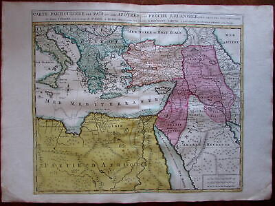
$11.85 Shipping Location: Dover, United States Carte Particuliere des Pais ou Les Apotres ont Preche l'Euan Gile; des Lieux les Plus Renommez de Leurs Voyages. Et de la Route de St. Paul a Rome. ... moreDressee pour bien entendre l'Histoire Sainte. Mediterranean. Arabia, Turkey, Greece, Armenia, North Africa) Issued Amsterdam. C. 1730-40 by Covens& Mortier. Fine mid-18th century engraved folio sheet map of the Mediterranean and Middle East. With original hand color. Quite interesting for the detailed depiction of Arabia. Armenia and Turkey during the time of the Apostles travels. In VG to near fine. Clean, well-preserved condition. A fine map. Sheet measures c. 24" W x 17" H. Printed area c. 18 1/4" W x 15" H. Folio. Tooleys Dictionary of Mapmakers. Vol. 1, p. 308. Marco van Egmond. Covens& Mortier. 3.3 R564. Everything we offer is guaranteed to be an authentic original antique item as described. We stand behind everything we sell. Important information for International Buyers* You may be charged customs. Taxes or other import duties by your country! this has nothing at all to do with us. Please do not hold us responsible if your Government wants to collect tax when you buy something outside of your country] Import duties. Taxes, and customs fees are not included in the item price or shipping cost. These charges are normally collected by the shipping service when the package is delivered or when you pick the item up. They are the buyer's responsibility and are not additional shipping charges. Please understand they have nothing to do with us and we have no control over them] Please check with your country's customs office to determine what these additional costs will be prior to bidding or buying. We do not know the various rules of your Customs office. There are a lot of countries in the world. Most with complex detailed variable laws in languages we don't read. Plus these laws are constantly being changed& revised] We won't under-value merchandise or mark the item as a gift on customs forms. Doing so is again
Buy It Now
$6.95 Shipping Location: Dover, United States Issued c. 1795-1806, Paris by Delamarche. Map by Vaugondy, revised and reissued by Delamarche. Judea ou Terre Sainte. Late 18th/ early 19th century engraved ... moremap with original outline hand color.
Buy It Now
$16.23 Shipping Location: New York, United States Manuscript map-making was a useful educational tool in the 19th century, a period of imperialism and increased world trade in which geography grew significantly ... moreas a field of study. This beautifully hand colored schoolgirl or schoolboy manuscript map of Canaan and Palestine (Israel or Holy Land) covers from Arish in northern Sinai north beyond Beirut.
Buy It Now
$6.53 Shipping Location: MARLOW, United Kingdom A map of Judaea, or the Holy Land, which is Divided into the Twelve Tribes of the Hebrews or Israelites. DATE PRINTED :c.1730. PROVENANCE: Laor 930. VERSO ... more: There is nothing printed on the reverse side which is blank.
Buy It Now
$9.99 Shipping Location: Ivanhoe, Australia This original hand coloured steel-plate engraved original antique map by Sydney Hall was published in the 1840 edition ofHalls General Atlas published ... moreby Longman & co., London. (Ref: Tooley; M&B). Date: - 1840.
Buy It Now
$10.00 Shipping Location: Cyprus After his ordination, 17 March 1696, he was appointed to teach philosophy and theology at the Ab-bey of Moyenmoutier. Fine original antique copper plate ... moreengraving with hand coloring. Condition: Nice map in good condition.
Buy It Now
$4.95 Shipping Location: Dover, United States Wady Maghara, Sinai. Issued 1883, New York by D. Appleton & Co. Engraved by C. Cousen. Attractive and detailed 19th century steel engraved print.
Buy It Now
$8.70 Shipping Location: Vero Beach, United States The Arrowsmiths were a family of English mapmakers. He was joined in 1810 by his nephew John Arrowsmith. "Drawn under the direction of M. Arrowsmith. ... moreHall sculpt. Published for the Society for promoting Christian Knowledge, by M. Rivington, St Paul's Church Yard, London, May.".
Buy It Now
$14.00 Shipping Location: Seattle, United States This map is 10 3/8" x 15 3/4". It is 10 1/4" x 15".
Buy It Now
$6.95 Shipping Location: Dover, United States Issued 1865 Gotha by Justus Perthes for Sprunner. Engraved by Alt. Very detailed mid-19th century engraved historical map with original outline hand color.

Buy It Now
$15.00 Shipping Location: Brooklyn, United States 1854 Mitchell Map of Turkey. Syria, Iraq, and the Holy Land WE SELL ONLY ORIGINAL ANTIQUE MAPS- NOT REPRODUCTIONS Title: Map of Turkey in Asia. Description: ... moreA fine example of Thomas Cowperthwait and S. A. Mitchell’s 1854 map of Turkey in Asia. Centered on the Holy Land. This map covers the Asian territories claimed by the Turkish Ottoman Empire c. 1850. These include the modern day countries of Turkey, Cyprus, Syria, Jordan, Lebanon, and Iraq. An inset in the lower left quadrant details the environs of Constantinople and the Bosporus Straits. The important caravan route from to Rosrah, on the Persian Gulf, is noted. The whole is engraved in Mitchell’s distinctive style with green border work and vivid pastels. Political and topographical features are noted and color coded with elevation rendered by hachure. This map was prepared by S. A. Mitchell for publication by the Philadelphia firm of Thomas Cowperthwait& Co. as plate no. 66 in the 1854 edition of Mitchell’s New General Atlas. Dated and copyrighted, Entered according to act of Congress in the year 1850 by Thomas Cowperthwait& Co. in the Clerk's office of the Eastern District of Pennsylvania. Size: Printed area measures 12.5 inches high by 15 inches wide. Condition: Very good condition. Blank on verso. Shipping: Due to recent increases in United States Postal Service rates we have been forced to increase our shipping rates. Shipping rates are not negotiable. Items are shipped within three business days of receiving payment. We are happy to consolidate shipping where possible. The following shipping options are available: 1. USPS Domestic Express Mail(35 USD) USA Only. 2. USPS Priority Mail(15 USD) USA Only. 3. USPS International Express(35 to 55 USD) Recommended service for all international parcels. You will be invoiced at the lowest Express Mail rate possible. 4. USPS Priority Mail(35 USD) Available to only certain countries. Due to high instances of loss. This service is specifically NOT AVAILABLE to MAINLAND CHINA or INDIA. 5. Federal Expres
Buy It Now
$15.00 Shipping Location: Cyprus Verso Dutch text.: Beschrijving van het Het Beloofde Lant Canaan. Title: Het Beloofde Landt Canaan door wandelt van onsen Salichmaecker Iesu Christo. ... moreTaken from the Dutch Keur State Bible : De Gantsche Heilige Schrifture.Pieter Keur 1720.
Buy It Now
$25.00 Shipping Location: Belvedere Tiburon, United States Map of Western Palestine from surveys conducted for The Committee of the Palestine Exploration Fund. By Lieuts. An Introduction to the Survey of Western ... morePalestine. This is a fine example of this special edition of Kitchener & Conder’s map of Western Palestine, published in 1882, the year following the issuance of the first edition of the map.
Buy It Now
$10.00 Shipping Location: Cyprus Palestine, Israel map, La Judée ou Palestine. Brian 1766. His most important work is generally considered to be his General Atlas of 1766. Title: La Judée ... moreou Palestine. Louis Brion de la Tour (1756 - 1823) was a Ingenieur-Geographe du Roi.
Buy It Now
$10.04 Shipping Condition: Unspecified Location: LONDON, United Kingdom PROVENANCE: "Atlas Universel de Geographie Ancienne et Moderne", Par M. Lapie et M. Lapie Fils. D�di� au Roi. CONDITION: Good; suitable for framing. Large ... more(folio) antique atlas map with original hand colour, 1833.
Buy It Now
$15.00 Shipping Location: Israel Paper size: 25"x21". Good condition for age, see scans.
Buy It Now
$8.70 Shipping Location: Eagle, United States Map Palestine George F Cram 1899 S6-05. Featured is an original and authentic map from 1899 of Palestine.
Buy It Now
$25.00 Shipping Location: Cyprus Title: Ierusalem. He spent most of his working life in Frankfurt. After his death, his sons Matthäus Jr. and Caspar took over the publishing house. Origin: ... moreNeuwe Archontologia Cosmica Printed in Frankfurt ca. 1650.
Buy It Now
$15.00 Shipping Location: Cyprus Israel Holy Land Old Map La Judee Depuis Vaugondy 1757. Tems de N.S. Jesus-Chris. Charles François Delamarche was the one that the publishing house Didier ... moreRobert de Vaugondy had acquired. (in 1786.).
Buy It Now
$15.00 Shipping Location: Israel Palestine, Middle East; Jacques Bonfrère - Tabula Geographica Terrae Sanctae, (Map of the Holy Land) - 1721-1750. Tabula geographica Terrae Sanctae, map ... moreof Palestine, edited by Jacques Bonfrère. Hand-colored engraving, from La galerie agréable du monde, by Pieter van der Aa.
Buy It Now
Free Shipping Condition: Used Location: Israel
Buy It Now
$5.95 Shipping Location: Dover, United States Issued 1874 Gotha by Justus Perthes for Stieler. Engraved by Jungmann. Very detailed 19th century engraved map with original outline hand color. Original ... morecenter fold as issued.
Buy It Now
$10.00 Shipping Location: Cyprus Author: Willem Albert Bachiene; Jan van Jagen. Title: Afbeeldinge der Stad Jerusalem benevens de darom heen gelegene bergen en dalen, fonteinen, waterleidingen ... moreenz. Publisher: Nicol. Origin: Heilige Geographie of Aardrijkskundige beschrijving van het Joodsche land.

Buy It Now
$17.80 Shipping Location: Bolivia, United States 17773] Morse. Sidney. The Cerographic Bible Atlas. New York: Sidney E. Morse& Co. 1844. Cover printed in letterpress, with a decorative border surround ... moreand inset woodcut view of the City of Jerusalem; 5 total, printed one side only, with outline color; maps included: General Map of the Countries Mentioned in the Bible; Map of the Journeyings of the Israelites in the Desert chiefly from the map of Robinson and Smith; Map of Palestine from the Latest Authorities chiefly from the map of Robinson and Smith; Plan of Jerusalem from the map of Robinson and Smith& Environs of Jerusalem from the map of Robinson and Smith; Map of the Travels of the Apostles chiefly from the map of Dr. Augs. Neander; maps sight at 14 1/2" x 12" approx; overall 17 1/2" x 14" size approx. back cover with title"Morse's Cerographic Bible Atlas" cerography was the process of engraving on a wax-covered metal plate for which a printing surface is prepared by electrotyping; previous owner name on front cover of Rev. W. Hunting; printed on medium stock paper, better than Morse's later atlas newspaper printings; original pale yellow paper softcover printed wraps; some spotting and foxing, wear, closed tears to some maps, covers more so; some chipping to edges, paper curling at edges; given that this was an ephemeral newspaper supplement, in good condition overall. Normal 0 false false false EN-US X-NONE X-NONE Normal 0 false false false EN-US X-NONE X-NONE Normal 0 false false false EN-US X-NONE X-NONE Normal 0 false false false EN-US X-NONE X-NONE Normal 0 false false false EN-US X-NONE X-NONE Normal 0 false false false EN-US X-NONE X-NONE Normal 0 false false false EN-US X-NONE X-NONE
$25.00 Shipping Location: Perugia, Italy Jean-Claude Dezauche (fl. 1780-1838) was a French map publisher. The De L'Isle family (fl. Claude De L'Isle (1644 -1720), the family patriarch, was Paris ... morebased a historian and geographer under Nicholas Sanson. ).
Buy It Now
$15.00 Shipping Location: Portugal GENERAALE KAART VAN HET BELOOFDE LAND. Highly decorative map of the Holy Land by I. Elwe. THe present map was published in Amsterdam in 1792. Attractive ... morehand colour.
Buy It Now
$30.00 Shipping Location: Paris VI, France His most famous work is his translation of Ptolemy's Geographia, which was published after his death. Edition : edited by Giordano Ziletti, Venice, 1574, ... moreitalian text on verso page 19. Title of the map.
Buy It Now
$6.95 Shipping Location: Dover, United States Issued 1810, Paris by Lapie. Engraved by Adam & Giraldon. Empire D'Alexander. Scarce early 19th century antique engraved map with original hand color. ... moreDictionary of Mapmakers, vol.
Buy It Now
Free Shipping Location: Downingtown, United States
Buy It Now
$7.00 Shipping Location: Defuniak Springs, United States Map Of Palestine & The Holy Land. from Monarch Standard Atlas 1904 Atlas.
|
|
|
|
c 1960 Bibby Travel Guide JORDAN JERUSALEM The Holy Land w/ Map
c 1960 Bibby Travel Guide JORDAN JERUSALEM The Holy Land w/ Map Your Bibby Travel and Tourism to Jordan The Holy Land. Agent Eunice H. Avery. Dover road, Longmeadow, Mass. Unfolds to a map of interesting sights in Jerusalem and Jordan. Opens fully to a selection of tours available. Dates for the 1960's. Condition is very good with bends. Edge wear and soiling. Corners bumped. Measures 9 5/8 by 17 5/8" Normal 0 false false false MicrosoftInternetExplorer4 TERMS: Scan is an accurate representation. Item is guaranteed to be authentic and as described and is returnable. Items are shipped by USPS. Free first class postage within USA. $6.88 for international first class rate. Shipping for multiple items will be combined. Kentucky residents include 6% sales tax. Email with questions prior to bidding. Your bid indicates that you have read. ... moreUnderstand, and agree to these terms.
|
|
|
CYPRUS, HOLY LAND, ISRAEL, Munster original antique hand coloured map c1580
CYPRUS. HOLY LAND, ISRAEL, Munster original antique hand coloured map c1580, CYPRUS. HOLY LAND, ISRAEL, Munster original antique hand coloured map c1580 CYPRUS. ISRAEL, HOLY LAND, PALESTINE, JORDAN by Sebastian Munster Published Basel circa 1580 in Munster's Cosmographia. An untitled 16th century wood cut map of The Holy Land. Present day Israel, Syria, Jordan, Palestine, Cyprus and Lebanon. Cities. Forests and mountains shown in pictorial bird's eye form. Coverage is from Medina in the south, through Petra, Nazareth, Bethlehem and Jerusalem to Beirut(Berytus) Cyprus and Antioch in the north. A sailing ship is featured in the Mediterranean with information panels in Latin. Enhanced with attractive later hand colouring. Latin text and a further uncoloured smaller map of The Middle East on verso. Fine condition. Free of repairs or restoration. ... moreApprox. 10" x 7" 260mm x 170mm) map area only. Sheet size approx. 12.5" x 8.5" 320mm x 210mm) on hand laid paper. Please see also close up and image of verso. Sebastian Munster(1488-1552) was a great German scholar and cartographer who first published his Cosmographia in 1544. It was a sweeping encyclopoedia of the 16th century world which was a massive influence on all who followed. It was translated into many languages and continued to be published until 1628. Long after his death. A GENUINE ANTIQUE MAP GUARANTEED OVER 380 YEARS OLD FROM LINDISFARNE PRINTS FXC413 We do not deal in reproductions. Facsimiles or modern copies of any kind. SHIPPING 2 items shipped with a single shipping charge. Free shipping worldwide if three items or more purchased. Closeups, Shipping Process, Two items are always combined for shipping and three items or more are shipped free of charge. Worldwide"Please see item description for postage costs" Payment Options, All major Credit and debit cards via PAYPAL. Personal cheque drawn on UK banks only. Postal Orders from UK post offices only. Bank transfer- please email for details. About Us, Lindisfarne Prints is
|
|
|
6 Placemats Christian Sites Pictures & Israel Holy Land Map, 2 SIDED Table Set
Normal 0 false false false MicrosoftInternetExplorer4 Normal 0 false false false MicrosoftInternetExplorer4 Normal 0 false false false MicrosoftInternetExplorer4 Normal 0 false false false MicrosoftInternetExplorer4 Normal 0 false false false MicrosoftInternetExplorer4 Normal 0 false false false MicrosoftInternetExplorer4 Israel Holy Land. Land of the Bible- 6 Placemats/ Table Mats With a detailed Geographical Biblical Map of the Holy Land on one side. And nice pictures from holy places in Israel on the other side, biblical sites where Jesus has placed his foot: Jerusalem City, Jerusalem- Mount Zion, Bethlehem City, Bethlehem- Church of Nativity, Ein Karem, Nazareth, Tabgha, Mount of Beatitudes You are getting 4(four) placemats for this attractive price. Large. Flexible and washable Plastic Placemats that will help you keep a clean table! ... moreSize(L x W) 18 x 12 inch/ 45 x 30 cm Normal 0 false false false MicrosoftInternetExplorer4 Click here to see other Holy Land gifts in Our Store Normal 0 false false false MicrosoftInternetExplorer4_ Feel free to email us with any question Liorel. Art from Israel Find a special gift Unique art works& gifts. Handmade by Israeli artists Vintage antiques& collectibles from the early days of Israel_ Ordering& Shipping Information Shipping Worldwide from Israel. All orders are insured for loss or damage Shipping Options: Express. Standard and Sea mail. By default. Parcels up to 2 kg will be sent by standard Airmail and over 2 kg by Express mail. Shipping by sea is cheaper and takes over a month, please contact us for a quote Shipping Time(to most places in the world) Standard mail: 7-14 business days(1-3 weeks) Express mail: 4-5 business days. Sea Mail(Economy) 1-2 months Shipping Enquiries: Delivery depends on the mail services of your country and delivery times of up to one month can occur in few cases(like holiday times or distant locations) Pl
|
|
|
HOLY LAND ISRAEL JERUSALEM PALESTINE GAZA JUDEA ENGR. MAP MERCATOR 1607 !! #B266
Rare! Original and decorative old-coloured copper engraving map by Gerard Mercator. Printed by Jodocus Hondius in Amsterdam, 1607 AD out of the Atlas: Atlas sive cosmographicae meditationes de fabrica mundi et fabricati figura. auctus ac illustratus à Iudoco Hondio. Editio secunda" Splendid map of the Holy Land- Israel- Palestine! Terra Sancta quae in sacris Terra Promissionis ol: Palestina. Cartographer: Gerard Mercator(1512-1594) was a Flemish cartographer and mathematician. He was born in Rupelmonde in East Flanders in the Holy Roman Empire of the German Nation to parents from Gangelt in the Duchy of Jülich(modern Germany) Since 1552 he lived in Duisburg. He is considered as the Ptolomy of his time. Publisher: Jodocus Hondius( 1563; 1612) was a Flemish artist. Engraver, and cartographer. The second Amsterdam edition of the ... moregreat Mercator Atlas by Joducus Hondius. Hondius had acquired from the map in 1604 by Gerard Mercator's heirs the copper plates. 1606 appeared his first Amsterdam edition of Mercator's Atlas complete. Augmented by 37 new cards that had Hondius acquired by different authors. This stock now 144 cards was in the 2nd Amsterdam edition of 1607 extended for a further two cards. Already in the following year, the second edition was sold out and a third edition appeared as unchanged reprint of the edition of 1607. Description: We offer an original and large-size old-coloured copper engraving map by Gerard Mercator. This interesting and detailed copper engraving map shows the Holy Land. Today Israel and Palestine bordering the Mediterranean Sea, the Jordan and the Sead Sea as well as Syria. The cities of Jerusalem, Gaza, Bethlehem, Gallilea, Damascus, Hebron and Massada can be spotted. The map is decorated with two splendid cartouches and a ship and seadragon. Very rare collection item! Size: Leaf app. 51.0 x 43,3 cm engraving app. 49.4 x 35,5 cm Condition: in good condition strong print and paper well-preserved old-colour slightly brownish and stained one small restored tear a
|
|
|
Vintage 1955 Guide Map of Jerusalem Jordan The Holy Land = Double sided
UP FOR AUCTION Is a Vintage 1955 Guide Map of Jerusalem Jordan The Holy Land Ahlan Wa Sahlan I Combine Shipping Dollar Bill is not included in auction. It is used for a size comparison. Up for auction is a Vintage 1955 Guide Map of Jerusalem Jordan The Holy Land Ahlan Wa Sahlan Map measures 16” wide and 23” tall. And is double sided. Please look over the pictures before bidding. I do my best to describe everything but just in case please look over the pictures for exact condition, If you have any questions please let me know Shipping and Handling Shipping to the lower 48 states is $3 I do combine shipping if you win more than one item.
|
|
|
1744 T.C. Lotter Uncommon nice map of Israel Palestine Holy Land
Terra Sancta Vocata. Quae Olim XII Tribus… Original uncommon r educed version of Seutter's large map of the Holy Land divided into the twelve tribes of Israel. The large pictorial title cartouche illustrates the Bible story of baby Moses. A second smaller cartouche includes a map of the Exodus from Egypt. Engraved with high detail and great care by Tobias Conrad Lotter. From Atlas minor Praecipua Orbis Terrarum. published in Augsburg in 1744 by Lotter. Size: 255 x 200 millimetres- 10 x 7.8 inches Condition: Strong paper. Nice dark impression. Original colouring. Overall in good condition. All of the maps we sell are Originals. Authentic and in Good condition. Payment via bank transfer, Paypal or Visa/MC. Please email me for any question or photos.
|
|
|
1772 Pluche Map of the Holy Land
1772 Pluche Map- La Terre Sainte Noel-Antoine Pluche. Also known as L'Abbe Pluche, was a French priest who wrote one of the most popular natural history works of the 18th century- Le Spectacle de la Nature which was first published in 1732. Although primarily about natural history it also contained maps and engravings of a geographic nature in the fourth volume of eight published. It was also translated into English in 1740. He then completed'Concorde de la Geographie' which was published posthumously. This map comes from a later French edition of 1772 of'Concorde de la Geographie' published well after his death in 1761. It shows the Holy Land stretching from the Lebanese mountains in the north to the southern tip of the Dead Sea in the south. The engraving measures 5.5" by 5.5" Has one fold(as issued) wash hand ... morecolouring, and is in very good condition. The engraving is guaranteed to be over 225 years old. Shipping United States- Regular airmail $5.00US. Registered/insured airmail(optional) is an additional US$15.00 for a total of US$20.00. Canada- $3.00US for regular mail. $9.00US for registered mail. Canadian customers please add GST or HST as applicable. Sorry, we cannot arrange for pick up of ebay items. Rest of the world- Regular air mail $8.00US. Registered/insured airmail(optional) is is an additional US$15.00 for a total of US$23.00. Terms and Conditions Please note- We can only take responsibility for delivery if the optional registration/insurance is added. Regular airmail is usually very safe and reliable. But items sent by regular airmail are at the buyers risk- regular airmail provides no tracking number, no proof of shipping or delivery, and no insurance in case of loss or damage. Please note- Mailing from Canada to the United States and all other international destinations can sometimes take over three weeks for delivery. We will combine shipment of multiple purchases- several items can be shipped together for one shipping cost. Payment Options We accept Paypal. Beach
|
|
|
ANTIQUE MAP - 1782 - ISRAEL - 12 TRIBES - HOLY LAND - Bonne -1782
iscra antique maps& prints Description: Antique map of the Holy Land showing the twelve tribes of Israel's. By R. Bonne, printed in 1782(later hand coloring) Tribes are all named along with numerous place names, towns and villages. Very elaborate title cartouche. On the right side of the map is an inset of text, scale bars and a legend of village symbols, Royales’ Levitiques’ and‘de Refuge’ Date: 1782. Size: The overall size is 21.5 x 14 1/4 inch. The image size is 17,5 x 12,5 inch. Technic: copper engraving. Condition: Very Good A Certificate of Authenticity will be added! THERE IS FREE SHIPPING FOR ADDITIONAL ITEMS! Thanks for looking! ISCRA STORE* We accept Paypal payments and Bank transfer payments! Combined orders possibl e! Insurance included! ISCRA- store ISCRA is a member of the international antiquarian map sellers association ... moreWE GUARANTEE ITEMS SOLD ARE IN THE CONDITION DESCRIBED. ITEMS CAN BE RETURNED WITHIN 14 DAYS FOR REASONS OF AUTHENTICITY. Powered by The free listing tool. List your items fast and easy and manage your active items.
|
|
|
Antique map-ANCIENT PALESTINE-HOLY LAND-ISRAEL-Cellarius-1731
ABOUT US VISIT OUR STORE SALES SPECIALS Antique map-ANCIENT PALESTINE-HOLY LAND-ISRAEL-Cellarius-1731 Description: This authentic print originates from: Notitia orbis antiqui. Sive geographia plenior �' by Christoph Cellarius, ed. published in Leipzig by Johann Frederick Gleditsch in 1731-32. Ref. Brunet I, 1724. Ebert 3868. An early standard work on the geography of Classical Antiquity first published in 1686. Artists and Engravers: Author: Christoph Cellarius(1638- 1707) or Christopher Keller was a German scholar. Historian and textbook publisher. Cellarius held academic positions in both Weimar and Halle. Cellarius's most important work was his 1683 publication of'A Universal History Divided into an Ancient, Medieval, and New Period. It was in this work that the concept of history as divisible into three distinct ... moreperiods(Ancient History, Mediaeval History, and Modern History) was introduced. It had great impact on the way future historians would interpret the past. Subject: Map: Palaestina sev Terre Sancta. Palesstine and the Holy Land. With decorative cartouche showing King David and Moses. Condition: Very good given age. General age related toning. Paper edges a bit irregular from binding. Original folds as issued. Ocassional light folding. Please study scan carefully. Size(in cm) The overall size is ca. 22.5 x 34.5 cm. The image size is ca. 20 x 30 cm. Size(in inch) The overall size is ca. 8.9 x 13.6 inch. The image size is ca. 7.9 x 11.8 inch. Medium: Original copperplate engraving on verge type hand laid paper. Location: A253-33 ThePrintsCollector Peter Cornelissen. Margo van Latum- van Dongen, Frank van Latum Zeeland- The Netherlands Phone: +31 654 21 23 78 Worldwide free shipping on all orders. We ship within one business day upon receipt of payment. We ship by Registered Mail. Insurance is included. We guarantee our items to be genuine original. Visit our Store: we would like to invite you to review similar items in our Store or to browse through all other items in our Stor
|
|
|
PILGRIM'S MAP OF HOLY LAND FOR BIBLICAL RESEARCH- 27 X 19" (1970'S?)
based on research from 1942 also includes booklet on Upper Galilee-tourist guide map has some light edge wear and browning on the back where folded I do my best to describe the item(s) But I am human. And if something fails to live up to your expectations I would like to know about it before any negative feedback or low ratings are left. I value your business and want to provide a pleasant experience. Returns are accepted for items not as described or defective. Note to international buyers. I love to ship to you. But I have no control over prices for shipping or times for shipping. Please don't buy unless you understand that.
|
|
|
Vintage Pilgrim's Map of the Holy Land for Biblical Research Th. F. Mathesy 1977
For sale is a vintage Pilgrim's Map of the Holy Land for Biblical research. Including the most important sites from the Old and New Testaments, complied by TH. F. Mathesy. The map is in very good condition and was printed in Israel in 1977.
|
|
|
1820 ORIGINAL Map of Jordan, Syria, Holy Land, Tribes of Israel
Original uncolored engraving as issued. Blank on verso. Engraved by Pierre Bellier. Paris. Based upon the work of Poison. Image area is 12.5" w. X 9.25" h. Interesting and detailed map of the Northern Tribes of Israel. Beautifully executed will frame nicely. Overall good condition with mild ageing. Low starting bid with no reserve. Shipping cost is for insured domestic priority mail.
|
|
|
ANTIQUE MAP - 1710 - JERUSALAEM - ISRAEL - HOLY LAND - Danckerts - Schut
iscra antique maps& prints'De Stadt Jerusalem' Description: Antique bird's eye view of Jerusalem by Cornelis Danckerts. Engraved by Albert Schut, printed in 1710. At the bottom are the Temple Salomon's and a panoramic view of Jerusalem.Thise map is based on the imaginary plan by Vilalpando and is the first state with Cornelis Danckerts privilege below the title. There is Dutch text on verso. Date: 1710 Technic: Copper engraving with later hand coloring. Size: The overall size is 20.5 x 16 inch.The image size is 19,5 x 13,5 inch. Condition: Very Good; small restored margin tear; folds as issued + an extra fold along one of the original folds. A Certificate of Authenticity will be added! THERE IS FREE SHIPPING FOR ADDITIONAL ITEMS! Thanks for looking! ISCRA STORE* We accept Paypal payments and Bank transfer payments! Combined ... moreorders possibl e! Insurance included! ISCRA- store ISCRA is a member of the international antiquarian map sellers association Because of different configurations of monitors colours can appear a bit different on you screen. The sizes of the pictures are(most of the time) not the real print size. The real sizes are noted in the description area. Import duties. Taxes and charges are not included in the item price or shipping cost and are buyer's responsibility. WE GUARANTEE ITEMS SOLD ARE IN THE CONDITION DESCRIBED. ITEMS CAN BE RETURNED WITHIN 14 DAYS after delivery or pick-up date Powered by The free listing tool. List your items fast and easy and manage your active items.
|
|
|
Turkey Holy Land Palestine Ottoman c.1858 antique lithograph hand color map
Turquie d'Asie(Turkey in Asia or the Ottoman Empire in Asia) Issued c.1858. Paris by Vuilemin Fine and uncommon original antique lithograph map with lovely hand color. Printed on quality handmade paper which retains its inherent structural flexibility and soundness. In near VG or better condition. Minor light surface age wear, light uniform age toning as typical, scattered foxing or staining, as well as some slight edge wear, overall the image is clean and very attractive, well worthy of ownership[note: we grade very conservatively and always seek to disclose any noteworthy flaws] The printed area remains visually pleasing. A nice impression of an interesting antique map. Any minor defects along the sheet edges and in the margins may be seen in the photos. Sheet measures c. 11 7/8" W x 9 1/4" H. Printed area measures c. 10" ... moreW x 7 1/2" H. 64397] Guaranteed Authentic! We do not sell modern reprints. Condition: We only handle. Sell& ship original vintage and antique items. Old sheets of paper, printed long ago. Items which are really old, like we say. Not modern copies or modern reproductions. It's amazing how many people still ask us if an item is truly old& genuine. We strive to describe our items accurately. We understand you cannot see it in person. We are trying to present it accurately and convey condition correctly with careful digital photography. Accurate flat-bed scans of the item which are zoomable, precise printed sheet& image sizes and knowledgeable descriptive words. It is important to understand& remember that many old printed paper items survive merely by chance. And all are somewhat unique if you inspect them closely. Few of the same type match exactly if compared side-by-side. Each has it's own characteristics and patina. Sometimes the differences are minor, other times quite noticable. Individual pieces have typically seen numerous owners and been handled many times over the course of their existence. On old sheets of paper. Short edge splits( which
|
|
|
1603 Ortelius Map HOLY LAND Ornate Cartouches, Dramatic Jonah & Whale Vignette
Terra Sancta 50 cm x 37 cm copperplate engraving. 56 x 44 cm sheet size, modern hand colour, Antwerp, engraved 1584, printed 1603 We are pleased to offer this scarce example of the classic map of the Holy Land(Van der Krogt 8150:31. Laor 543) from the 1603 Latin edition of the Theatrum Orbis Terrarum of Abraham Ortelius(1527-1598) The first true atlas in the modern sense. One of the more decorative maps of the Theatrum. Ortelius here presents an eastern oriented map based on cartography collected by Dutch astronomer Peter Laicksteen who visited Palestine in the 1550s and whose work was expanded upon by the geographer(1525-1603) in the production of a wall map of the region in the 1570s. Extending from Beirut to Gaza along a somewhat distorted coastline. The"sideways" eastern orientation of the map became a model for later mapmakers ... moresuch as Hondius and was arguably the definitive European cartographic conception of the region for the better part of half a century. The map features an ornate title cartouche with three vignettes of the life of Jesus, a flamboyant mileage scale with a gorgon head and a spectacular scene at lower left of Jonah being thrown overboard to the whale. This well-preserved example of the map is enhanced with hand colour work of the very highest order, and will make an elegant presentation if matted and framed. The title cartouche credits Laicksteen and Sgrothen and features three miniature(3 cm diameter) vignettes of the crucifixion. Nativity and resurrection. Many of the ornate cartouche"frames" used by Ortelius' engravers were derived from a series of ornament prints published in the 1560s by the brilliant architect, painter, designer and graphic artist Hans Vredeman de Vries: Turning to the map itself. We find the precise calligraphy and skilled engraving work typical of Ortelius maps- to get a sense of map detail consider that the distance from Jerusalem to Hebron as seen below measures just 6 cm actual size. Note pictorial west of. But"beneath" Jerusale
|
|
|
1891 Antique Map Jerusalem Holy Land 123 Years old
This antique map was rescued from a dilapidated Encyclopedia Brittanica that could not be salvaged. The print date is 1891. The volume the map came from was xiii. There is minor discoloration around the edges. The map measures approximately 9.5" x 13 3/4" This is a great map for a collector and is ready to be framed.
|
|
|
Antique Print Map 1873 Holy Land Joppa Samaria Judea Simeon Great Sea
Original Antique Prints, E2741873112) Auction Title, FREE UK SHIPPING TODAY.Antique Print Map 1873 Holy Land Joppa Samaria Judea Simeon Great Sea. Description, MAP 1873 HOLY LAND JOPPA SAMARIA JUDEA SIMEON GREAT SEA A hand coloured double page from Dr William Smith ancient atlas dated 1873.Size of each print is 24 x 19 inches(610x490)All are genuine antiques not modern reproductions. Bought from an antique dealer at auction. Great value for all interior decorators. For hotels, public houses, bars, offices, public buildings, restaurants, bed and breakfasts, B& B, and homes. A PERFECT GIFT FOR ALL GIFT GIVING OCCASIONS LIKE CHRISTMAS BIRTHDAY ANNIVERSARY etc. SHIPPING& HANDLING TIME All orders are mailed 1 day or same day dispatch or next working day. UK by Royal Mail Recorded. International Signed for AIRMAIL for USA. £7.98 additional ... moreitems on same order will be FREE so if purchasing several add to basket to consoldate your order. Note seperate orders will each carry this international charge. Europe and Worldwide International Signed for by AIRMAIL. £7.98 additional items on the same order will be FREE so if purchasing several items add to basket to consolodate your order. Note seperate orders will each carry this international charge. Delivery time which is dependant on the various mail services involved. Enquiries OR email Royal Mail special delivery next day UK is offered at an extra cost of £6.98. See my Additional Info, Auction Sales Policy. IMMEDIATE PAYPAL PAYMENT REQUIRED. thank you Your bid is a contract- Place a bid only if you are serious about buying the item. If you are the winning bidder. You will enter into a legally biding contract to purchase the item. If the seller is unable to establish contact with the winning bidder within 1 days of the end of the auction or if payment is not received within 1 days, item may be offered to the next highest bidder or relisted at the sellers sole discretion. Returns. In the unlikely event that a return is requested. This must be done withi
|
|
|
DE GELEGENTHEYT VAN T’PARADYS HOLY LAND BIBLE MAP ISRAEL STOOPENDAAL KEUR 1738
. DE GELEGENTHEYT VAN T’PARADYS HOLY LAND BIBLE MAP ISRAEL STOOPENDAAL KEUR 1738 Title: De Gelegentheyt van't Paradys ende't Land Canaan mitsgaders de eerste bewoonde landen Der Patriarchen. Uyt de H. schrifture en verscheyden Auctoren bij een gestelt door Hendrik Jacob en Pieter Keur en Pieter Rotterdam. Description: Fine antique Bible map covers the region between the Mediterranean and the Persian Gulf. In double lines the path of Jacob from Canaan to Babylon. Near Cyprus a vessel and Jonah in the Whale. At bottom center is a large scene of Noah's Ark at the beginning of the Great Flood. The vignettes depicts numerous Biblical scenes from the Garden of Eden include scenes of Adam and Even in Paradise. Taken from the Dutch Keur State Bible: Biblia. Dat is de gantfche H. Schrifture, vervattende alle de Canonijcke Boecken des ... moreOuden en des Nieuwen Testaments, te Dordrecht by Jacob and Hendrik Keur Anno 1738. By: Hendrick Jocob en Pieter Keur en Pieter Rotterdam 1738. Vignettes engraved by Daniel Stoopendaal. Keur gave in 1666 their first Staten Bible out in Dordtrecht. Their first Bibles they gave out in company with Marcus Doornick printed in Amsterdam. Subsequent expenditure was also a cousin of Marcus Doornick namely Pieter Rotterdam. Amsterdam, involved. Bible Printers Keur: This was finally out respectively: Henry I. James I, Peter, Henry II and James II. The Keur Bibles contain normaly six large double page maps. 17th-18th Century maps& atlases& prints. ORIGINAL ANTIQUE COPPER PLATE ENGRAVING. HAND COLORED. Engraving is Absolutely Guaranteed authentic original map. A Certificate of Authenticity will be on request forwarded for each individual map or print. Sheet app. 46 x 32.5 cm. 18.25 x 13.25 inches. Image app: 45 x 30.5 cm. 17.75 x 11.75 inches. Condition: view very good. Edges chipping, folds as published, verso Bible text in Dutch. All maps and prints are genuine. Authentic, published at the date stated in this listing! For better quality pictures please go to our web site: WWW.
|
|
|
1661 Fine Scarce Cluver Map of the Holy Land
1661 Cluver Map- Palestinae Sive Totius Terrae Promissionis Philip Cluver(Cluverius) along with Christoph Keller(Cellarius) was one of the first geographical and historical authors to use different sets of maps to embellish their popular works. Cluver's magnum opus was'Introductionis in Universam Geographicam' which was issued in various sized editions from about 1650 to the mid-1700's. Different publishers used various cartographers and one of the most famous early editions was published by Jan Jansson in Amsterdam in 1661. This attractive and scarce map of the Holy Land comes from the Jansson edition and was engraved by Pieter van den Keere whose name appears at the bottom of the cartouche title. The area shown stretches from the Nile Delta in the west to Beirut. Lebanon in the north. Both the Dead Sea and Sea of Galilee ... moreappear prominently. There is a splendid cartouche title in the top left and a decorative scale of distance in the bottom right. The map measures 6" by 8" Has two folds(as issued) and excellent outline hand colouring. The map is in very good condition. The map is guaranteed to be over 350 years old. Shipping United States- Regular airmail $5.00US. Registered/insured airmail(optional) is an additional US$15.00 for a total of US$20.00. Canada- $3.00US for regular mail. $9.00US for registered mail. Canadian customers please add GST or HST where applicable. Sorry, we cannot arrange for pick up of ebay items. Rest of the world- Regular air mail $8.00US. Registered/insured airmail(optional) is is an additional US$15.00 for a total of US$23.00. Terms and Conditions Please note- We can only take responsibility for delivery if the optional registration/insurance is added. Regular airmail is usually very safe and reliable. But items sent by regular airmail are at the buyers risk- regular airmail provides no tracking number, no proof of shipping or delivery, and no insurance in case of loss or damage. Please note- Mailing from Canada to the United States and all other internationa
|
|
|
2005 Holy Land Israel Large Satellite Space Photo Map Poster 59"x19"
Up for sale is a really neat Satellite Poster of Israel from 2005. The colour data in this image was derived from the U.S Landsat-5 satellite. Which passed over the area at a height of 580 miles(930 KM) True-colour High-Resolution Image. The Poster is in great shape with very little wear, SEE PICTURES! It is has never been hung with no tack punctures. I accept PayPal within two days of the winning bid and ship Monday thru Friday within two days of received payment. Thank You!
|
|
|
1840 Endicott View and Map of th Holy Land
1840 Endicott View and Map of th Holy Land WE SELL ONLY ORIGINAL ANTIQUE MAPS- NOT REPRODUCTIONS Title: The Holy Land. Exhibiting the Places and Cities Mentioned in the Old and New Testament. Description: An uncommon view and map of the Holy Land. Israel, or Palestine by Endicott. Focusing on the city of Jerusalem, which is oversized and presented just right of center, this map covers the Holy Land from the Jorden River to the Mediterranean and from Sidon to Zoar. Some 85 biblical cites are noted as are both the Dead Sea and the Sea of Galilee. Damascus appears in the distance. The view is presented as an aquatint engraving with exceptionally fine renderings of topography and cities. The view was published in 1840 on behalf of the General Protestant Episcopal S. S. Union and the Church book Society of New York Size: Printed area measures ... more10.5 inches high by 26.5 inches wide. Condition: Very good. Backed with archival tissue for stability. Detached form but accompanied by original binder. Shipping: Due to recent increases in United States Postal Service rates we have been forced to increase our shipping rates. Shipping rates are not negotiable. Items are shipped within three business days of receiving payment. We are happy to consolidate shipping where possible. The following shipping options are available: 1. USPS Domestic Express Mail(35 USD) USA Only. 2. FedEx Ground or Home Delivery(15 USD) USA Only. 1- 10 days. If your address is a P.O.Box and cannot ship FedEx we will ship USPS Priority and. While we ship promptly, recent postal personnel cutbacks mean that delivery may take up to 1 month. 3. DHL International EXPRESS(40- 50 USD) 4. We can use your Federal Express Account. Insurance: All shipments are insured privately against loss and damage. All of our shipments require a signature. If you have any questions please feel free to email us through eBay or contact us by telephone at 646-320-8650. Additional Services Conservation Framing Services: Geographicus recommends basic conservation framing ser
|
|
|
Robert Vaugondy 1737 Antique Map. Acient World, Holy Land. Hemisphere Inset
Antique Copper Engraved Map Published 1737. Paris. Engraved Le Tellier after Robert Vaugondy. Hand coloured outline as published. Centre fold as issued. Partie orientale de la carte des anciennes monarchies" Light crease along centre fold. A couple of tiny margin tears. Paper Size: 28 x 21.5 inch(71 x 55cm)
|
|
|
PALESTINE - HOLY LAND 1868 Original Antique map ( Johnston )
If description does not show below- please try Internet Explorer Good quality ORIGINAL antique map Title: Palestine or Holy Land" Publication& Date: issued in Edinburgh 1868 by William Blackwood for Alexander Keith Johnstonr" Handy Royal Atlas of Modern Geography" Description: Large attractive map. Finely detailed. Battles. Note: The only road for wheeled carriages in Palestine is that from Beirut to Damascus by Zahleh opened in 1863. The others are only mule tracks. Under Turkish Rule Palestine is comprised in the 2 great Governments of Damascus E. of Jordan& Lebanon and Beirut or Sidon on the W. which are again divided into Pashalies named from principal towns but as the boundaries of these are very uncertain& frequently changed they cannot be put down on the map. Reverse is blank- suitable for framing Condition& ... moreSize: Clean and good condition- printed area 17"x12.5" 43x32cm) plus wide margins. Outline colour Postage: UK- Free- Europe- £5.50- Rest of World and USA- £7.50( Can combine postage) Visit our many other interesting listings of maps& prints on our Site(rediiwi) and in our E-BAY STORE Payment: Use Paypal or ask for details Thanks for looking
|
|
|
Rollin & Dufour 1817 Antique Map. Assyrie, Medie, Babylonie et Perse. Holy Land
Antique Steel Engraved Map Published 1827. Paris for"Atlas de Geographie Ancienne pour Servir a l'Intelligence des Ouvres de Rollin" Edited by M. Letronne. Maps by Dufour. Rollin, and Tardieu. Centre fold as issued. A couple of small margin tears. Paper Size: 20 x 13 inch(51 x 33cm) RcmdId ViewItemDescV4,RlogId p4%60bo7%60jtb9%3Fvo%7B%3Dd70f%2Bf54%3E-145e241b8a2-0x115-
|
|
|
HOLY LAND MAP NATIONAL GEOGRAPHIC Vintage Cartography Illustrated 1967—One Owner
Vintage 1967 Map(Original Owner—Rare Condition) HISTORY. I've had this map since I was a boy. It was never handled or used. In fact. It was just carefully unfolded it to take these photographs and I was amazed at the condition. Remaining folded and flat for over 46 years has helped maintain its new look. Several other maps I have are in the same rare condition. Vintage"specialty" maps of this educational caliber are highly collectible. The illustrations. Technical facts and amazing detail are a marvel to behold. The quality of what you see here is what you'd expect from the Cartographic Division of the: NATIONAL GEOGRAPHIC SOCIETY This highly respected institution is the Harvard of mapping. Not only is cartography used. This map features specially drawn graphic illustrations and features descriptive notes. Be sure to examine ... moreall the details in the photos presented. See the pristine condition and notice how unique it is. Gigantic 29" x 40" in size AUTHENTICITY: One family. Original condition. Real history. QUALITY: Printed in the U.S.A. Washington. 1967. RARITY: Specialty" maps with early findings such as this are very rare and highly desirable. PREPARATION: I go to great efforts to prepare each listing carefully presenting you with a quality item and his-res detailed photographs. This way you know precisely the history and the quality of what you are buying. Just the kind of excellence you would expect from a true one owner collectible. Be sure to check out all the other vintage maps I have listed from this same time period. EXTREMELY HARD TO FIND IN THIS CONDITION FROM THIS ERA ANYWHERE SHIPPING DETAILS: Even though I am currently running eBay single-handed. All packages are shipped within 3 business days. My policy is to make everyone who buys happy with their purchase and satisfied enough to return again. Therefore, a quick note from you is all it would take to sort out any problems which may infrequently arise. NOTE ON SHIPPING DELAYS: eBay shipping estimates are just that. Es
|
|
|
VTG 1942 PILGRIM'S MAP HOLY LAND FOLLOWING JESUS STEPS EXCELLENT CONDITION
1942 PILGRIM'S MAP HOLY LAND FOLLOWING JESUS STEPS EXCELLENT CONDITION THE ONE IN THE PICTURES. IN VERY GOOD CONDITION! IT WILL BE SENT FROM WASHINGTON. DC TRACKING NUMBER WILL BE AVAILABLE WITHIN 24 BUSINESS HOURS OF PAYMENT MADE
|
|
|
Map of The Holy Land "Land of The Bible In Roman Times" Vintage Framed Print
Land Of The Bible In Roman Times" This goldleaf framed print of unknown vintage is a vintage reproduction of a map engraving by Abraham Pinaeus(Pinet) A very famous 16th Century French artist. It appears to be quite old and in excellent condition(see pictures) This map has been drawn in a very pictorial way. With the names of places shortened according to the space available. It makes a great gift or conversation piece in your office or den. Measurements: 24" × 26 1/2" This item is being sold as-is and ships only within the contiguous 48 States.
|
|
|
1552 Uncommon woodcut Munster map of Cyprus, Holy Land, Syria & Middle East
Tabula Asiae IIII Interesting original early map showing the Middle East with Cyprus. Holy Land and Syria. Nice vignettes in the Arabia Deserta The decorative woodcut design on verso is attribuited to Hans Holbein. From Munster's uncommon Geographia Universalis. Vetus et Nova. Claudii Alexandrini. published in Basle in 1552* Size: 340 x 250 mm- 13.3 x 10 inches Condition: Stable white paper. Nice impression. Overall in very good condition. All of the maps we sell are Originals. Authentic and in Good condition. Payment via bank transfer, Paypal or Visa/MC. Please email me for any question or photos.
|
|
|
1844 Black Map of Palestine, Israel or the Holy Land
1844 Black Map of Palestine. Israel or the Holy Land WE SELL ONLY ORIGINAL ANTIQUE MAPS- NOT REPRODUCTIONS Title: Palestine according to its Ancient Divisions. Description: This is a scarce 1844 Adam and Charles Black map of Ancient Palestine. Israel or the Holy Land. It covers the region as it existed in Biblical times with divisions for each of the Twelve Tribes of Israel and includes the modern day nations of Israel, Palestine and Lebanon, as well as parts of adjacent Syria and Jordan. Various cities, towns, rivers, mountains and several other topographical details are noted with relief shown by hachure. This map marks both ancient and contemporary place names as well as the locations of Biblical events and ruined cities. The color coded outlines detail the region as it may have appeared in Biblical times, with the lands claimed by the ... morevarious Tribes of Israel noted. An inset map in the lower right quadrant details the Peninsula of Mount Sinai, where the cartographer notes, Mount Sinai, Mount Horeb, the ancient mountains of the Nile, and the Islamic Haj route. It shows the course of the Israelites as they fled out of Egypt, across the Red Sea, and subsequently spent the next forty years wandering in the Sinai before migrating into the Promised Land by crossing the Jordan River just north of the Dead Sea. The names of the Twelve Tribes are listed along the right margin. This map was engraved by William Hughes and issued as plate no. XXXVII in the 1844 edition of Black's General Atlas. Size: Printed area measures 15.5 inches high by 11 inches wide. Condition: Very good. Original platemark visible. Blank on verso. Shipping: Shipping rates are not negotiable. Items are shipped within three business days of receiving payment. We are happy to consolidate shipping where possible. The following shipping options are available: 1. USPS Domestic Express Mail(35 USD) USA Only. 2. FedEx Ground or Home Delivery(15 USD) USA Only. 1- 10 days. If your address is a P.O.Box and cannot ship FedEx we will ship USPS Priorit
|
|
|
1780 Bonne Map Balkans Turkey Holy Land Israel Iraq Middle East Russia Cyprus
Note that this is a 100% genuine antique map. I DO NOT sell copies. Posters, reproductions or fakes so you can buy with total confidence that you are buying the real thing! If you like this map. Then just message me with an offer for me to consider. This auction is for the extremely rare and 100% original and authentic antique map of the above region. Cartographer and year. This auction is only for the map that is pictured in this listing. I cannot stress enough how beautiful this map is up close compared to the photos that you see. Note that the photos do not do the map justice. This is truly an incredible map to behold! This is your chance to own a map that can be the centerpiece of your collection. Cartographer: Rigobert Bonne(1727-1795) was one of the most important cartographers of the late 18th century. In 1773 he succeeded Jacques ... moreBellin as Royal Cartographer to France in the office of the Hydrographer at the Depôt de la Marine. Working in his official capacity Bonne compiled some of the most detailed and accurate maps of the period. Bonne's work represents an important step in the evolution of the cartographic ideology away from the decorative work of the 17th and early 18th century towards a more detail oriented and practical aesthetic. With regard to the rendering of terrain Bonne maps bear many stylistic similarities to those of his predecessor. Bellin. However, Bonne maps generally abandon such common 18th century decorative features such as hand coloring, elaborate decorative cartouches, and compass roses. While mostly focusing on coastal regions, the work of Bonne is highly regarded for its detail, historical importance, and overall aesthetic appeal. General Description: 1. Strikingly interesting and highly detailed map. Beautiful hand coloring. The map depicts in great detail all of the geographical information known at the time the map was published. Note that many geographical details have changed since the map was published and were not accurate compared to today's modern maps becau
|
|
|
Large Map by Sanson Italy Greece Turkey Cyprus Arabia Holy Land - 1662
Original map by: Sanson: Geographia Sacra ex veteri et novo testamento. Age: 1662 Sheetsize: approx. 62 x 48 cm Condition: please see photo. Upper centrefold with long split and loss of paper Payment: Banktransfer or Paypal.
|
|
|
TERRA SANCTA JERUSALEM HOLY LAND PALESTINE ORIG. ENGR. MAP DE WIT 1680 #A730
MORE HISTORY COPPER ENGRAVING MAPS IN OUR AUCTIONS! WEITERE HISTORISCHE KUPFERSTICH KARTEN IN UNSEREN AUKTIONEN! Amazing! Original. Large size and wonderful coloured copper engraving map by Frederik De Wit, published in Amsterdam about 1680 A.D. Splendid Map of the Holy Land- Israel"Terra Sancta. Cartographer: Frederic De Wit(1630; 1706) was on of the most important publisher of atlasses and maps of its time. Description: We offer a decorative and coloured copper engraving map by Frederik De Wit. This detailed map showing the Holy Land- Palestine as well as adjacent areas. The map is decorated with a beautiful title cartouches. Size: Leaf app. 59.2 x 49,7 cm Map app. 55.5 x 46,5 cm Condition: in good condition strong print and nice colour slightly brownish and stained restored back side- center fold and parts of the margin and edges ... moreslihgtly creased Please have a look at the pictures! Please note all items auctioned are genuine. We do not sell reproductions. A Certificate of Authenticity(COA) can be issued on request. Prächtig! Originale.Großformatige und wundervoll kolorierte Kupferstichkarte von Frederik de Wit, herausgegeben in Amsterdam um 1680 A.D. Prächtige Karte vom Heiligen Land- Israel"Terra Sancta. Kartograph: Frederik De Wit(1630; 1706) war einer der wichtigsten Verleger von Karten und Atlanten seiner Zeit. Er leitete das Verlagshaus de Wit mit Sitz in Amsterdam nach dem Tod seines Vaters. Beschreibung: Wir bieten Ihnen hier eine dekorative und kolorierte Kupferstich Karte von Frederik de Wit an. Diese detaillierte Karte zeigt das Heilge Land- Palästina sowie die angrenzenden Gebiete. Die Karte ist mit einer prächtigen Titelkartuschen verziert. Maße: Blatt ca. 59.2 x 49,7 cm Karte ca. 55.5 x 46,5 cm Zustand: guter Zustand kräftiger Druck und schönes Kolorit etwas gebräunt und fleckig Rückseite restauriert- Mittelfalz. Stellenweise an den Rändern und Ecken angesetzt
|
|
|
ANTIQUE MAP OF HOLY LAND -BIRES-EYE-VIEW 1903 BUILDINGS ARE REFERENCED LOOK
THIS WOULD LOOK VERY NICE HANGING IN YOUR HOME OR IN AN OFFICE. ANTIQUE FRAMED 1903 CRAM'S FAMILY ATLAS MAP OF BIRDS-EYE-VIEW OF THE HOLY LAND. MAP IS IN EXCELLENT CONDITION WITH A MAP SIZE OF 10 X 12" POINTS OF INTEREST INCLUDE: BEIRUT. SOPHIM, CARMEL, MT. NAZARETH, HIRAM'S TOMB, RACHAEL'S TOMB, SEA OF GALLIEE, WATERS OF MEROM, STANHOPE CASTLE, TIBERAS, CHURCH OF THE ASCENSION, CONVENT OF ELYAS, ETC. A VERY NICE INDEX AT THE BOTTOM- LISTING ALL THE CITIES, RIVERS AND MOUNTAINS. VERY DETAILED AND ILLUSTRATED MAP! S0 MUCH HISTORY. I SHIP 5 DAYS A WEEK AND ALWAYS LEAVE FEEDBACKS. MAP WAS PRINTED IN 1903~~~~~~~~~~~READY TO FRAME& HANG~~~~~~~~ Powered by The free listing tool. List your items fast and easy and manage your active items. 0fe.RcmdId ViewItemDescV4,RlogId p4%60bo7%60jtb9%3Fuk%601d70f%2B%3E0fe-146c19b0c11-0x10d-
|
|
|
ANVILLE: Map Holy Land Palestine and Cyprus - 1818
O riginal engraving from: Anville: Atlas de Geographie Ancienne Published: 1818 Sheetsize: 52 x 35 cm Condition: please see photo Shipping-costs: see description. We combine shipping at no extra cost, if more than one item is bought Payment: Paypal or Banktransfer.RcmdId ViewItemDescV4,RlogId p4%60bo7%60jtb9%3Fuk.rp*a4%601gc%3E-146c27ad3be-0x109-
|
|
|
1890 ANTIQUE BIRDS EYE VIEW MAP OF PALESTINE ISRAEL HOLY LAND BIBLE JERUSALEM
1890 ANTIQUE BIRDS EYE VIEW MAP OF PALESTINE ISRAEL HOLY LAND BIBLE JERUSALEM This original antique map gives you an opportunity to examine in exquisite detail a piece of history. If you are interested in the past of this country and its people or have a desire to study where your family may have come from. Then this map gives you a rare look as the area was about 125 years ago. Once matted and framed, this map would make a perfect gift for a family member or friend they'll cherish forever. Origin of the map: The Home Knowledge Atlas" Published by Home Knowledge Association, Toronto, Canada. Date of issue: 1890 Size: The sheet measures 13" x 11" 33 x 28 cm) S/H: The map will be shipped by Air Mail. The shipping charge is: USA- 8.00 USD. World- 9.00 USD, Canada- 9.00 USD. The price includes the insurance and a strong, cardboard ... moretube with plastic plugs. Attention! There is no additional shipping charge for multiple purchases! Pay me securely with any major credit card through PayPal! Payment methods: US/Canada Buyers: Paypal. International Buyers: Paypal. Click Here. Double your traffic. Get Vendio Gallery- Now FREE!
|
|
|
Original 1876 Antique Bible Map ISRAEL Palestine IN THE TIME OF CHRIST Holy Land
Fine Adornment of Bible History. Impressive on Any Home of Office Wall. Imaginative& Creative Gift. 1876 Map of Palestine in The Time of Christ Drawn& Engraved by W. A. K. Johnston. Official Geographers. Engravers. Printers to Queen Victoria. Original 1876. 138-yrs-old. Map is in Good/Very Good Condition: No writings. Marks, or folds. Mild foxing. Nominal fraying. Not a Reproduction. Original Map Drawn& Engraved by William& Alexander K. Johnston. Official Geographers, Engravers, Printers to the Queen, for the 1876 Edition of O.D. Case's Bible Atlas: To Illustrate the Old& New Testaments, Published by O.D. Case& Company, Hartford, and A.H. Andrews& Company, Chicago, 1876; a copy of the Title Page of which is Included. Intricate Engraved Detail. Hand-Colored. Exceptional Map for the Collector or Makes Quite an ... moreImpressionable Gift. I Sell Only Original Maps: No copies or reproductions. Press Here to View My Collection. Impressive on Any Home or Office Wall. Dimensions: 8 1/4" x 10 1/2" Fine Adornment of Bible History. The Auction is for the Map Itself. A Frame is Not Included. The Framed Map Pictured is a Personal 1873 Bartholomew Featured to Show the Beauty of the Maps when Framed. Imaginative& Creative Birthday. Christmas, or Special Occasion Gift. Free Shipping Special(within the USA) All credit cards. Debit cards, and electronic checks accepted through Paypal. Maps are mailed within 1-3 days of payment and normally arrive within 3-5 days. Please email with any questions. Greetings from Historical Savannah. Georgia; founded 1733. Some. To beautify their halls, studies, galleries, or libraries.loveth, getteth, and useth maps, charts, geographical globes. John Dee. Advisor to Elizabeth I. Press The Link Below To View My Collection. Powered by The free listing tool. List your items fast and easy and manage your active items.
|
|
|
ISRAEL Holy Land huge 6 sheet MAP in a pocket case scale 1:100000 UTM grid 1994
ISRAEL Holy Land NATURE RESERVES AUTHORITY 6 SHEET MAP in a soft gray PVC pocket case SCALE- 1:100.000 GRID- UTM& ITM Universal Transverse Mercator coordinate system& Israeli Transverse Mercator YEAR- 1994 SIZE of each MAP- 90 cm x 70 cm CONDITION- EXCELLENT Grid Easting Northing ITM(Israeli Transverse Mercator) 222286, 631556, Israeli Cassini-Soldner) 172249, 1131586, Universal Transverse Mercator) 711563, 3518045, Israeli Transverse Mercator- ITM. RcmdId ViewItemDescV4,RlogId p4%60bo7%60jtb9%3Fvo%7B2d71f%2B4g7%3E-146c6e8b125-0x120-
|
|
|
1858 Original Antique Longs - Hughes Atlas Map - Israel / Palestine Holy Land
1858 Longs Classical Atlas Map Palaestina& Part of Syria( Israel/ Palestine" The Holy Land" Jordon River. Israel, Lebanon, Jordon, Syria. plan of Jerusalem. etc. Hand Colored Outline Constructed by William Hughes- Edited by George Long This is an original 1858 Engraved Plate- Book Print. Great for Framing! Condition: Good- some over toning and aging with center fold as issued- see pics) Approximate Size(inches) 8.5" x 11.5" Shipping& Handling: Canada- $ 4.50 U.S. U.S.A. $ 6.50 U.S. Combined Shipping Welcome: All Ads- Prints will ship for one single shipping cost- All Ads/Prints/Engravings with shipping cost of $6.50 U.S. or LESS will ship for a combined cost of $6.50 U.S. Email with any questions. Please wait for combined shipping invoice before paying for more than one purchase for combined shipping cost- DO NOT ... morepay seperately please) Ads-Prints will be shipped within an Acid Free Archival Poly Protector between cardboard and in a Shipping Envelope. Please allow 2 weeks for delivery. Thanks! Thanks For Looking! Please email with any questions.
|
|
|
ANTIQUE MAP Holy Land JUDEA SAMARIA Charte Von Dem Juedischenlande S. GYSIN 1818
An ANTIQUE( dated 1818) MAP Of The HOLY LAND- JUDEA and SAMARIA- Charte Von Dem Juedischenlande- The map measures approximately 13" wide by 14" tall- The Condition is Very Good with age appropriate wear- There is some creasing and light discoloration as can be seen in the photographs- German Language- Printed by S. GYSIN in 1818- Liestal. Germany- The map is framed in a black wood pencil frame with old glass and cardboard backing- EXCELLENT ANTIQUE ITEM-
|
|
|
PALESTINE - LARGE 1855 MAP OF THE HOLY LAND (original) * Beautiful Hand-Coloring
ANTIQUE HAND-COLORED MAP( genuine) The Holy Land PALESTINE- 1855- This is a very historic map. An antique map of Palestine made in the year 1855. Six years before the American Civil War began. This great antique map will make a wonderful display piece– it measures 15-1/2 by 12-1/2 inches and it shows the entire area of Palestine, from Galilee down to Judea. There are literally hundreds and hundreds of details in this map- towns and villages. Lakes and rivers, mountains and roads. The entire land of Palestine is beautifully hand-colored, its various regions distinguished by different pastel shades of color. Surrounding Palestine, left uncolored to distinguish the boundaries, but also in great detail, are the lands of Idumea(or Edom) Bashan, Coele Syria, etc. This map is filled with historic areas. Both exotic and familiar: Zebulon, Land of ... morethe Philistines, Samaria, Asher, Issachar, Gad, Manasseh, Idumea, Henicia, Ammon, Judah, Simeon, Naphtali, Reuben, Ephraim, the Mountains of Moab, the Dead Sea, and many. Many individual towns and cities, And at the bottom of the map. There is a very detailed inset map of the City of Jerusalem. This map is very finely detailed. With even the tiniest detail sharp and clear. Such incredible detail work was only possible because the map was made from a finely engraved metal plate. It was produced first as a black-and white engraving, and then was meticulously hand-colored. This was the usual method of producing colored plates of any sort before the advent of printed color. The famous wildlife engravings of Audubon and others were produced in exactly the same way, starting as uncolored engravings which were later hand-colored. The coloring in hand-colored plates, including maps such as this one, is much more vivid and“alive” than printed color, and this map will display beautifully. The light pastel
|
|
|
'HET BELOOFDE LANDT CANAAN'. Holy Land. VISSCHER, 1661 antique map
Het beloofde landt Canaan door wandelt van onsen Salichmaecker Iesu Christo nessens syne Apostolen A very decorative uncoloured engraved map. 1661 Title of map: Het beloofde landt Canaan door wandelt van onsen Salichmaecker Iesu Christo nessens syne Apostolen' The image below shows an enlarged cross section from the centre of the map to show the level of printed detail. This map is folding hence the centrefold line may show on the image below: The map is orientated towards the west. With the Mediterranean shore of Israel/Palestine at the top, with the Dea Sea and the Sea of Galilee shown inland. The map depicts the Holy Land with four scenes from the life of Christ, title cartouche, two other cartouches surrounded by cherubs, and two fisherman. DATE PRINTED: 1661 IMAGE SIZE: Approx 34.0 x 49.5cm. 13.5 x 19.5 inches(Large) Please note ... morethat this is a folding map. ARTIST/CARTOGRAPHER/ENGRAVER: Claes Janszoon Visscher(1587- 19 June 1652) A Dutch Golden Age draughtsman, engraver, mapmaker and publisher. PROVENANCE: Published in Amsterdam in 1661 TYPE: A very decorative uncoloured engraved map VERSO: There is nothing printed on the reverse side. Which is plain CONDITION: Good; suitable for framing. Small repaired tear in left hand margin not extending inside the border of the map. Please check the scan for any blemishes prior to making your purchase. Virtually all antiquarian maps and prints are subject to some normal aging due to use and time which is not obtrusive unless otherwise stated. I offer a no questions asked return policy- see below. AUTHENTICITY: This is an authentic historic print. Published at the date stated above. I do not offer reproductions. It is not a modern copy. The term'original' when applied to a print means that it was printed at the first or original date of publication; it does not imply that the item is unique. Print' means any image created by applying an inked block to paper or card under pressure by any method including wood engraving, steel engraving, copperplate, wood cu
|
|
|
1842 ORIGINAL MAP OF ANCIENT HOLY LAND PALESTINE ISRAEL JERUSALEM ISRAELITES
THIS IS AN ORIGINAL MAP. NOT A RECENT COPY OR REPRODUCTION. Origin of the map: Atlas de precis de la Geographie Universelle. Malte-Brun, Paris(France) HAND COLOURED Date of issue: 1842 Size: The sheet measures 12" x 15" 30.5 x 38 cm) S/H: The map will be shipped by Priority International Air Mail. The shipping charge is 7.50 USD( with the tracking number) Or 6.00 USD( without the tracking number) If you wish to save 1.50 USD on the tracking number. Please let me know before you send the payment. Then wait for my invoice. Attention! There is no additional shipping charge for multiple purchases!
|
|
|
C. 1870 DUTCH MAP HOLY LAND MIDDLE EAST JERUSALEM ISRAEL 13" X 8".
C. 1870 DUTCH MAP HOLY LAND MIDDLE EAST JERUSALEM ISRAEL. MEASURING 13 INCHES BY 8 INCHES. CUT FROM A BOOK WITH UNEVEN LEFT MARGIN. THE PAPER IS HANDMADE AND THERE ARE DEXRIPTIONS ON THE BACK. WE HAVE OTHER HOLY LAND MAPS FROM THIS ESTATE ALSO LISTED ON EBAY. TYPE IN MAP) IN THE SEARCH MODE IN THE EBAY STORE. IN EXCELLENT CONDITION. HIGHEST BIDDER ADD FOR PRIORITY MAIL SHIPPING AND INSURANCE BASED ON THE RATE CALCULATOR IN THE U.S. OUTSIDE THE U.S. IS AS CHARGED. SHIPPING IS QUOTED IN U.S. FUNDS FOR U.S. LOCATIONS VIA PRIORITY MAIL USPS BASED ON THE RATE CALCULATOR. OUTSIDE THE U.S. WILL BE MORE.NOTE. DUE TO PAY PAL BUYER AND SELLER PROTECTION RULES. INTERNATIONAL BIDDERS MUST USE INTL PRIORITY MAIL FOR SHIPPING TO PROVIDE TRACKING CUSTOM NUMBERS ALL INTERNATIONAL BIDDERS ARE RESPONSIBLE FOR THEIR COUNTRYS DUTIES. IMPORT FEES, ETC WHERE APPLICABLE. ... moreSMALL ITEMS MAY GO IN SMALL PACKET HOWEVER IT MUST BE NOTED BEFORE YOU BID. NOTE. BIDDERS REQUIRED TO HAVE A RATING OF 7 OR MORE TO BID. THIS AUCTION MAY BE PAID FOR USING PAY PAL IN U.S. FUNDS. OR YOU MAY USE YOUR CREDIT CARD TO PAY ON PAY PAL. OR YOU CAN USE YOUR CREDIT CARD OR DEBIT CARD TO BE CHARGED TO MY MERCHANT ACCOUNT. INTERNATIONAL BIDDERS MUST USE PAY PAL IN U.S. FUNDS. OR CAN USE A CREDIT CARD TO PAY ON THEIR PAY PAL ACCOUNT. I HAVE THE ABILITY TO USE VISA OR MASTERCARD FOR PURCHASES AND WILL EMAIL YOU SHOULD YOU DECIDE TO PAY THIS WAY. ALL INTERNATIONAL BIDDERS MUST PAY FOR USPS INTERNATIONAL PRIORITY MAIL INSURED OR IF TOTAL IS IN EXCESS OF 70.00 SHIPPING MUST BE WITH USPS EXPRESS MAIL WHICH PROVIDES INSURANCE AND TRACKING. IF YOU HAVE QUESTIONS. ASK BEFORE BIDDING. THANK YOU. Powered by The free listing tool. List your items fast and easy and manage your active items. Froo www.froo.com | Froo Cross Sell. Free Cross Sell, Cross promote, eBay Marketing, eBay listing Apps, eBay Apps, eBay Application.
|
|
|
OLD MAP PRINT PALESTINE ANTIQUE WORLD SEA HOLY LAND ISRAEL JUDAISM JUDAICA
SCARCE PRINT. SHIPPING COST WORLDWIDE: 7$ REGISTERED SHIPPING COST WORLDWIDE: 9$ SHIPPING COST FOR THE EACH ADDITIONAL PRINT: 1$
|
|
|
Vivien Large Map of Syria Palestine Holy Land - 1824
O riginal engraving from: Vivien: Syriae Published: approx. 1824 Sheetsize: approx. 57 x 40 cm Condition: please see photo Shipping-costs: see description. We combine shipping at no extra cost, if more than one item is bought
|
|
|
ISRAEL, SYRIA, CYPRUS, HOLY LAND, Mallet original antique map 1719
ISRAEL. SYRIA, CYPRUS, HOLY LAND, Mallet original antique map 1719, ISRAEL. SYRIA, CYPRUS, HOLY LAND, Mallet original antique map 1719 SYRIE ANCIENNE by Alain Manesson Mallet. Published Frankfurt 1719 in"Beschreibung des ganzen Welt Kreises. A German translation of Mallet's"Description de L'Univers. A copper engraved antique map of present day Syria. Israel, Lebanon, Jordan, Palestine, Cyprus etc. Fine condition. Free of repairs or restoration on hand laid paper. Blank verso. Approx. 5.5" x 4" 140mm x 110mm) printed area only with good margins beyond. ALLAIN MANESSON MALLET(1630- 1706) Mallet started out as a soldier serving King Louis XIV as an inspector of fortifications but later was appointed as mathematics teacher at the King's court. He is chiefly remembered however for his publications of" Description ... morede L'Univers" 1683) in 5 volumes. And"Les Travaux de Mars ou l'Art de la Guerre" 1684) in 3 volumes. A GENUINE ANTIQUE MAP GUARANTEED OVER 290 YEARS OLD FROM LINDISFARNE PRINTS T82614 We do not deal in reproductions. Facsimiles or modern copies of any kind. Two items shipped for a single postage charge. Free shipping worldwide if three items or more purchased Closeups, Shipping Process, Two items are always combined for shipping and three items or more are shipped free of charge. Worldwide"Please see item description for postage costs" Payment Options, All major Credit and debit cards via PAYPAL. Personal cheque drawn on UK banks only. Postal Orders from UK post offices only. Bank transfer- please email for details. About Us, Lindisfarne Prints is a small family business specialising in genuine antique maps and prints at affordable prices.Established in 1995 and trading online since 2000. We pride ourselves on accurate descriptions, good communications, rapid service and fair prices. We are proud to maintain a 100% positive feedback rating which we hope reflects this.To avoid confusion, no item less than 100 years old is ever offered for sa
|
|
|
Original c1702 Dutch Map Holy Land Jerusalem Palestine Jacob Lindenberg
Original c1700 Dutch map out of a book mounted(glued) and missing about 2 inches on the right and a small chunk out of the top left. Size of the actual map is 18x15 inches. Shipping is $9.00 to the US No International Shipping PayPal Only Combined Shipping when applicable
|
|
|
Vilnay HOLY LAND MAPS limited Edition Book Jewish Map Judaica Palestine Israel
Vilnay HOLY LAND MAPS limited Edition Book Jewish Map Judaica Palestine Israel Rarest Zeev Vilnay.Ph.d. Hebrew book"Eretz Israel in Old Views and Maps" limited edition. Printed in only 510 numbered copies. This copy number 321. With 400 Views and Maps according to places of the Holy-Land. 176 pages. Edited and written by the Israeli Historian Zev Vilnay.Ph.d. Copyright by Rubin Mass, Jerusalem,1961. Printed in Israel. Hard Linen cover. Sizes: 23 x 32 cm. Very rare book. Very Desired by collectors as a book of reference. And as limited edition very fine bibliofile book. Condition: VERY FINE. Shipping& Handling: $12(registered air mail. Worldwide) In Israel $5. Payment: I accept PayPal. Look for my other Judaica Items up now. Thank you. And good luck. inkfrog terapeak.
|
|
|
Holy Land Antique map TERRE DES FILS DE CANAAN Moullart Sanson 1717
. Holy Land Antique map TERRE DES FILS DE CANAAN Moullart Sanson 1717 Title: Terre des Fils de Canaan Dont Ils s'emparerent sur les Descendans de Sem… Par le Sier Moullart Sanson. Pierre Moullart the grandson of Nicolas Sanson) Decorative antique map of the land of Canaan the Promised Land Holy Land to the Israelites by God. With a inlay map of the Garden of Eden. Engraved by Delahaye and Gerard Scotin. Nicolas Sanson(1600-1667) Nicolas Sanson(1600–1667) was a French cartographer. He was born of an old Picardy family of Scottish descent. At Abbeville, on the 20th(or 31st) of December 1600, and was educated by the Jesuits at Amiens. See: From: Atlas Géographie pratique. Avec les cartes necessaires. le plan topographique. Chamereau in Amsterdam. Sanson's principal works are: Galilee antiquae descriptio geographica(1627) Graeciae ... moreantiquae descriptio(1636) L'Empire romain(1637) Britannia. Ou recherches de l'antiquité d'Abbeville(1638) in which he seeks to identify Strabo's Britannia with Abbeville; La France(1644) Tables méthodiques pour les divisions des Gaules(1644) L'Angleterre. L'Espagne, l'Italie et l'Allemagne(1644) Le Cours du Rhin(1646) In Pharum Galliae antiquae Philippi L'Abbe disquisitiones(1647-1648) Remarques sur la carte de l'ancienne Gaule de César(1651) L'Asie(1652) Index geographicus(1653) Les Estats de la Couronne d'Arragon en Espagne(1653) Geographia sacra(1653) L'Afrique(1656) Sanson. Nicolas(1656) Le Canada ou Nouvelle France, c. Paris: Chez Pierre Mariette. Sanson, Nicolas(1658) Cartes générales de toutes les parties du monde, Paris: P. Mariette. And later editions. 17th-18th Century maps& atlases& prints. ORIGINAL ANTIQUE COPPER PLATE ENGRAVING. HAND COLORED. Engraving is Absolutely Guaranteed authentic original map. A Certificate of Authenticity will be on request forwarded for each individual map or print. Size: Sheet app. 52 x 41 cm. 20.5 x 16 inches. Image app. 40.5 x 35 cm. 16 x 13.75 inch
|
|
|
Rare 1894 Map of The Holy Land as Alloted by Joshua to the 12 Tribes of Israel
Rare 1894 Map of The Holy Land as Allotted by Joshua to The 12 Tribes of Israel by W& A.K. Johnston. Measures 15.5" by 11.75" A rare and very attractively engraved Victorian era lithograph that will look great matted and framed. See photo's. Free Shipping to anywhere in the US. Your order will always ship within ONE BUSINESS DAY. Well packaged in a sturdy waterproof mailer and sent with a delivery confirmation. I ship worldwide. Froo www.froo.com | Froo Cross Sell. Free Cross Sell, Cross promote, eBay Marketing, eBay listing Apps, eBay Apps, eBay Application.
|
|
|
1911 LARGE VICTORIAN MAP ~ PALESTINE (HOLY LAND) SAMARIA DECAPOLIS JUDEA
Beautiful ANTIQUE MAP on quality paper EXCELLENT condition and rescued from a disbound KEITH JOHNSTON'S HANDY ROYAL ATLAS 1911 THIS MAP IS AN ORIGINAL- OVER 100 YEARS OLD AND NOT A REPRODUCTION THIS MAP WAS PRODUCED IN 1911 PRINTED ON THICK PAPER WITH VIBRANT OUTLINE COLOUR"The Handy Royal Atlas Of Modern Geography Exhibiting The Present Condition Of Geographical Discovery And Research In The Several Countries. Empires And States Of The World by Keith Alexander Johnston. This DOUBLE PAGE FOLD-OUT map measures approximately 18 1/2 inches by 14 1/2 inches(470mm x 370mm) PLEASE VIEW IMAGE TO SEE HANDLING& AGE RELATED MARKS Printed on quality paper The map is free from any text or image on the reverse A superb map in excellent condition Please email with any questions regarding this item(Handy Royal Atlas 1911) BEST OFFERS PLEASE ... moreFOR A QUICK SALE AT A FAIR PRICE If you like the item. But do not like the price, then make a realistic offer to us using the MAKE OFFER BUTTON Powered by
|
|
|
Israel (1) 1986, Souvenir Sheet ,Map of the Holy Land, Scott 951
GREAT SOUVENIR SHEET(1) ISRAEL 1986. MAP OF THE HOLY LAND SCOTT 951 MINT NEVER HINGED WE COMBINE SHIPPING
|
|
|
1900 MAP OF PALESTINE ISRAEL HOLY LAND / JERUSALEM CITY INSET MAP
1900 MAP OF PALESTINE ISRAEL HOLY LAND/ JERUSALEM CITY INSET MAP This original antique map gives you an opportunity to examine in exquisite detail a piece of history. Once matted and framed. This map would make a perfect gift for a family member or friend they'll cherish forever. Origin of the map: The Citizen's Atlas of the World" Edited by J. G. Bartholomew, published in London, U.K. by George Newnes. Date of issue: Ca. 1900 Size: The sheet measures 18" x 14" 46 x 35 cm) S/H: The map will be shipped by Air Mail. The shipping charge is: USA- 8.00. World/Canada- 9.00. The price includes the insurance and a strong, cardboard tube with plastic plugs. Attention! There is no additional shipping charge for multiple purchases! Pay me securely with any major credit card through PayPal! Payment methods: US/Canada Buyers: Paypal. ... moreInternational Buyers: Paypal. Click Here. Double your traffic. Get Vendio Gallery- Now FREE! USED USED. AN ORIGINAL ANTIQUE MAP. USED.
|
|
|
1850 ORIGINAL Map of Palestine, Holy Land, Jerusalem, Israel, Syria
Original hand colored engraving as issued. Blank on verso. Engraved by George E. Sherman. Published by Henry Seibert& Bros. Image area is 8.5" wide x 12.0" high. Interesting and detailed map showing chief cities. Villages& road system. There is an inset map of Jerusalem. Beautifully executed. Attractive hand color, will frame nicely. Overall good condition with mild ageing. Centerfold is intact. Low starting bid with no reserve. Postage charge is for domestic insured priority mail. RcmdId ViewItemDescV4,RlogId p4%60bo7%60jtb9%3Feog4d72f%2Bf7%60%3E-146edc6355d-0x11c-
|
|
|
Mortier: Large Decorative Map Holy Land Israel - 1700
Original engraving from: Mortier: Heylige Land Published: 1700 Sheetsize: 53 x 45 cm Condition: please see photo Shipping-costs: see description. We combine shipping at no extra cost, if more than one item is bought Payment: Paypal or Banktransfer
|
|
|
Mortier: Large Decorative Map Paradise Holy Land Ninive Babylon - 1700
Original engraving from: Mortier: Paradis Terrestre Published: 1700 Sheetsize: 53 x 45 cm Condition: please see photo. Lower centrefold split(5cm) Shipping-costs: see description. We combine shipping at no extra cost, if more than one item is bought Payment: Paypal or Banktransfer
|
|
|
National Geographic Map Supplement - Holy Land Today: December 1963
National Geographic Map Supplement- Holy Land Today: December 1963 25" x 19"
|
|
|
A New Map of Palestine or The Holy Land, engraved hand color - W.H. Holmes 1876
A New Map of Palestine or The Holy Land. Engraved hand color- W.H. Holmes 1876 Title: A New Map of Palestine or the Holy Land Maker: W.H. Holmes. Drawn& engraved- Philadelphia Date: 1876 Printing: Lithograph Measures: 9 1/2" x 11 1/2" Description: original hand color lithograph drawn& engraved by W.H. Holmes. Philadelphia- 2 pages of text page accompany the piece(as shown in the scans) Ships within the U.S. only. California residents will be charged sales tax. inkfrog terapeak. I000000. InkFrog Analytics. RcmdId ViewItemDescV4,RlogId p4%60bo7%60jtb9%3Fuk.rp*4a24%60%3C%3E-146fa6be1c4-0x109-
|
|
|
map handcolored carte 1840s vuillemin Holy Land Palestina Jerusalem biblic bible
vuillemin All handcolored Check the other maps for potential combined shipping
|
|
|
1908 MAP PALESTINE ISRAEL HOLY LAND EGYPT SINAI PENINSULA SUEZ CANAL GAZA STRIP
1908 MAP PALESTINE ISRAEL HOLY LAND EGYPT SINAI PENINSULA SUEZ CANAL GAZA STRIP This original antique map gives you an opportunity to examine in exquisite detail a piece of history. Once matted and framed. This map would make a perfect gift for a family member or friend they'll cherish forever. Origin of the map: The Harmsworth Atlas And Gazetteer" Published in London, England by Carmelite House. Date of issue: 1908 Size: The sheet measures 20" x 15 1/4" 50 x 39 cm) S/H: The print will be shipped by Air Mail. The shipping charge is: USA- 8.00 USD. World- 9.00 USD, Canada- 9.00 USD. The price includes the insurance and a strong, cardboard tube with plastic plugs. Attention! There is no additional shipping charge for multiple purchases! Pay me securely with any major credit card through PayPal! Payment methods: US/Canada ... moreBuyers: Paypal. International Buyers: Paypal. Click Here. Double your traffic. Get Vendio Gallery- Now FREE! USED USED. AN ORIGINAL ANTIQUE MAP. USED.
|
|
|
PALESTINE, ISRAEL, HOLY LAND, P.BERTIUS orig. hand col. antique map 1606
PALESTINE. ISRAEL, HOLY LAND, P.BERTIUS orig. hand col. antique map 1606, PALESTINE. ISRAEL, HOLY LAND, P.BERTIUS orig. hand col. antique map 1606 PALAESTINA by Petrus Bertius Engraved by Pieter Van Den Keere and Published Amsterdam 1606 by Cornelium Nicolai, in; Tabularum Geographicarum Contractarum Libri Quinque" An original early 17th century copper engraved miniature antique map of Palestine and the Holy Land by Petrus Bertius. Covers present day Israel. N.E.Egypt, Palestine, Lebanon, part of Syria etc. The title is displayed in a cartouche featuring angels, with the further title of Descriptio Palaestinae in the upper margin. The Mediterranean Sea area is embellished with a sailing ship and sea monster. A fine map enhanced with attractive later hand colouring. A crisp dark impression on robust hand laid paper with Latin text to ... moreverso. Fine condition. Free of repairs or restoration. Approx. 5" x 3.5" 120mm x 85mm) map area only. With full margins beyond. Petrus Bertius 1565-1629 Also known Pieter or Peter Bertius of Flemish birth he was educated at Leiden University and was a theologian. Historian and mathematician of some standing, but is remembered chiefly for his cartographic works. His brothers in law Joducus Hondius and Pieter Van Den Keere were also highly successful cartographers and engraved many of the maps for the Tabularum Geographicum Contractarum. A GENUINE ANTIQUE MAP GUARANTEED OVER 400 YEARS OLD FROM LINDISFARNE PRINTS We do not deal in reproductions. Facsimiles or modern copies of any kind. T41514 SHIPPING Two Items will be combined with a single shipping charge. Free shipping worldwide if three items or more purchased Closeups, Shipping Process, Two items are always combined for shipping and three items or more are shipped free of charge. Worldwide"Please see item description for postage costs" Payment Options, All major Credit and debit cards via PAYPAL. Personal cheque drawn on UK banks only. Postal Orders from UK post offices only. Bank transfer- please email for
|
|
|
1707 (1696) Homann (Sanson) Map ISRAEL Holy Land "Terra Sancta" Superb Vignettes
Iudaea seu Palaestina ob sacratissima Redemtoris vestigia hodie dicta Terra Sancta prout olim In Duodecim Tribus Divisa. 56.5 cm x 48.5 cm copperplate engraving. 59 cm x 51 cm sheet size, original hand colour, Nuremberg, 1707 We are pleased to offer this scarce example of the first map of the Holy Land divided into the 12 Tribes published by the renowned Johann Baptist Homann(1663-1724) This first state of the plate(Laor# 340) was issued prior to Homann's appointment as Royal Geographer in 1715. A somewhat ironic title as although he was unsurpassed as a master engraver Homann was not really a true cartographer and his maps were typically close copies of earlier maps, usually French, which he reworked with flamboyant cartouches and vignettes as is the case here. The cartography and even the title of the map is in fact copied from the ... more1696 map of the Holy Land by Guillaume Sanson(1633-1703) with Homann's bold and dramatic decorative elements making up more than a quarter of the plate. A true masterwork of the engraver's art, this well-preserved example will make a fine presentation if matted and framed. The enormous title cartouche presents a central image of Moses receiving the Ten Commandments with a vignette at left of the Israelites worshiping the Golden Calf and a scene at right of manna falling from heaven to the encamped Israelites during the years of wandering the desert: Twin putti present the dramatic title"banner" which gives credit to Sanson as author of the map: At lower right Moses and Aaron are seen viewing an inset map of the desert wanderings of the Israelites. While soldiers carry a bundle of dates: Map extends as far north as Damascus- note tiny"forests" and bold pictorial topography. Another Homann engraving specialty: To get a sense of map detail. Consider that the distance between Jerusalem and Bethlehem as seen below measures just 2 cm actual size. Note Sodom and Gomorrah shown beneath the Dead Sea: Condition- Please note carefully: The map is in very good con
|
|
|
National Geographic Map: Holy Land December 1989 (N189)
Shipping Information National Geographic Map: Special Places of the World: Holy Land December 1989(N189) Description: Here is a National Geographic map titled Special Places of the World: Holy Land dated December 1989. This particular map has two sides. Both of which are listed below with pictures and descriptions. If you are planning on buying more than one of my maps make sure you read the shipping information below. Click on the thumbnails to see the enlarged pictures. December 1989(31"x20" Side A: This map has lots of historical. Religious and geographical facts from the Stone and Bronze Ages(CA 500,000 to 1200 BC) to the Islamic Period(AD 640 to 1971) Special Places of the World: Holy Land- December 1989(31"x21" Side B: This map has lots of details of the history of this land inhabited by Jews. Christians, and Muslims. ... moreHas a great illustration of Jerusalem with historical sites noted. Please Note: The vast majority of the maps I have up for sale are in excellent condition and look just as good as the map in the picture. However. Some of these maps, especially the older ones, might have some small defects, such as a small tear or soiling at the seams. I will make every effort to send you the best map I have. If the map does have one of these small defects, I will email you and let you know what the defect is, and give you the option of cancelling the auction or giving you a discount on the shipping cost. N189) This map weighs 35 grams Be sure to check out my page for information on my web site dedicated to helping you find a particular National Geographic map to meet your needs. Shipping Information: If just buying one map the shipping cost will show up in your invoice. I will gladly ship multiple maps in one package to save you the cost of shipping. Just buy the maps you want and wait for me to combine all your auctions together into one invoice and revise the shipping cost before you pay. To get an idea of the shipping cost read below. Most of my maps will be sent by Canada Post Letter m
|
|
|
1909 ANTIQUE MAP OF PALESTINE ISRAEL HOLY LAND DEAD SEA
1909 ANTIQUE MAP OF PALESTINE ISRAEL HOLY LAND DEAD SEA This original antique map gives you an opportunity to examine in exquisite detail a piece of history. If you are interested in the past of this country and its people or have a desire to study where your family may have come from. Then this map gives you a rare look as the area was about 105 years ago. Once matted and framed, this map would make a perfect gift for a family member or friend they'll cherish forever. Origin of the map: Cassell's Atlas" Published by Cassell and Co, Ltd. in London, New York, Toronto and Melbourne. Date of issue: 1909 Size: The sheet measures 14" x 10" 36 x 25 cm) S/H: The map will be shipped by Air Mail. The shipping charge is: USA- 4.00 USD. World- 6.00 USD, Canada- 3.00 USD. The price includes insurance and a strong, secure bubble ... moremailer. Attention! There is no additional shipping charge for multiple purchases! Pay me securely with any major credit card through PayPal! Payment methods: US/Canada Buyers: Paypal International Buyers: Paypal. Click Here. Double your traffic. Get Vendio Gallery- Now FREE!
|
|
|
ISRAEL PALESTINE TURKEY JERUSALEM HOLY LAND KAISER WILHELM VISIT PANORAMA MAP
See scan(s) please. HAPPY BIDDING! VERY LOW STARTING PRICE! WE COMBINE ALL LOTS! ALL ITEMS WILL BE SENT AS REGISTERED MAIL($ 5.00) UP TO 5 ITEMS. BUYER IS KINDLY REQUESTED TO ADD $ 0.50 FOR EACH ITEM AFTER THE 5th ITEM WON. Large size image(s) available on: 002649 Powered by The free listing tool. List your items fast and easy and manage your active items.
|
|
|
1609 Geneva Roman Letter Bible Leaf/ISRAEL/MAP OF THE HOLY LAND!
P 1606 Geneva Quarto Roman Letter Bible Leaf/ISRAEL/MAP OF THE HOLY LAND! Please see the special story below this description and please note the following: This leaf has an interesting story: Up until the turn of the 19th Century. Men went around in horse drawn carts collecting bones and rags(cloth) The bones were used to make glue and the rags(cloth) were used to make pages much as wood pulp is used today. They earned the nick-name"rag and bone men" These leaves can actually be ironed(carefully) This is an authentic Geneva Roman Letter Bible Leaf printed by Robert Barker in 1609! This leaf has a MAP OF THE HOLY LAND FROM THE BOOK OF JOSHUA! Measures about 6" X 8" in good condition with some browning and will come with a Certificate of Authenticity. Your purchase will be sent with acid free sheets for protection. 6/14 ... morePLEASE NOTE: it is recommended that antiquarian cloth leaves be framed with archival(acid free) materials, or if stored(this offers the best protection) with acid free materials. Avoiding direct sunlight or fluorescent lighting is highly recommended. FRAMING(QUARTO AND SMALLER) AVAILABLE FOR AN EXTRA CHARGE. This does not include UV Filtering glass. Rare/Religion/Theology. PLEASE VIEW MY EBAY STORE(put this link in your search box http:www.stores.ebay.com/hisbooks?refid=store) The items are arranged in categories for your easy perusal. PLEASE BOOKMARK IT! I have felt it necessary to mention that although I sell Bibles that contain the apocrypha, it is not the inspired Word of God. This is in CASE anyone wonders or might be led to think that it is part of the inspired writings, that is the Old and New Testaments, they alone are. Please contact me if you would like to hear/have Bibles for sale or have a specific request, or the possibility of making payments. Also if you would be interested in obtaining a quantity of leaves for a Church fundraiser. Or specific Scripture verses and/or specific engravings. Insured shipping/handling $4.99(outside the 48 states shipping may be higher)
|
|
|
1870 LARGE COLORED ANTIQUE MAP PALESTINE OR THE HOLY LAND ENGRAVED BY JOHNSTON
BEAUTIFUL LARGE ORIGINAL COLORED MAP ENTITLED PALESTINE OR THE HOLY LAND ENGRAVED AND PUBLISHED BY W& A.K.JOHNSTON EDINBURGH& LONDON YEAR: 1870 APPROX SI ZE OF MAP: 46.5 X 36,7 APPROX LITTLE DEFECTS ON WHITE MARGIN. IMAGE OF MAP IN GOOD CONDI TION RARE FOR COLLECTOR NS. PRT. N°7219
|
|
|
1899 ANTIQUE MAP OF PALESTINE ISRAEL HOLY LAND LEBANON
1899 ANTIQUE MAP OF PALESTINE ISRAEL HOLY LAND LEBANON This original antique map gives you an opportunity to examine in exquisite detail a piece of history. If you are interested in the past of this country and its people or have a desire to study where your family may have come from. Then this map gives you a rare look as the area was about 110 years ago. Once matted and framed, this map would make a perfect gift for a family member or friend they'll cherish forever. Origin of the map: Meyers Hand-Atlas" Published by Bibliographisches Institut in Leipzig, Germany and Vienna, Austria. Date of issue: 1899 Size: The sheet measures 11 3/4" x 9 1/2" 30 x 24 cm) S/H: The map will be shipped by Air Mail as a Letter. The shipping charge is: USA- 4.00 USD/ Canada- 1.80 USD/ World- 6.00 USD. The price includes a strong. Secure envelope. ... moreAttention! There is no additional shipping charge for multiple purchases! Pay me securely with any major credit card through PayPal! Payment methods: US/Canada Buyers: Paypal. International Buyers: Paypal. Click Here. Double your traffic. Get Vendio Gallery- Now FREE!
|
|
|
Original 11x15 MAP of the HOLY LAND in the TIME OF CHRIST! "Must See!"
I ask for payment by Pay Pal within 3 days of auctions end, and I do file for nonpayment. Also… I do combine on shipping. For items won within a 24 hr. period. Note: I ship U.S.A. only Thank You and good luck! As with most of the items. I list here on ebay. They come from a local auction. And I know very little about that item. Below is one of them items. For your consideration. I have an Interesting. Original, 11 x 15 inch Map of the HOLY LAND in the TIME OF CHRIST! That would look great. Matted and Framed.At the auction, that I purchased this item from, it was stated to be very old, before the 1900s. At the very top it is printed Long East from Wash. On the bottom it is printed Long East from Greenwich. And on the very bottom Engraved by D. Griffing Johnson. New York. The Holy Land in the time of Christ by D. Griffing Johnson 1 edition ... morepublished in 1862 in English and held by 1 WorldCat member library worldwide) In the last photo you can see that it appears to come from an old page in a book. That is in very good to excellent condition. With a small tear at the top and bottom of the fold. So let my photos be your guide. And Thank You for looking! Powered by The free listing tool. List your items fast and easy and manage your active items.
|
|
|
1820 MAP OF THE HOLY LAND Engraving; Flavius Josephus RARE
Ebay Member since August 2001 Quality Antique prints. Maps& Ephemera- Guaranteed Antique unless otherwise specified ~~~~~~~~~~~~~~~~~~~~~~~~~~~~~~~~~~~~~~~~~ This listing is for an 1820 map by E. Khull. From the date stated and not a later reproduction, entitled: Map of the Holy Land A detailed engraved biblical map showing the area of the Mediterranean Coast. Egypt and the Mouth of the Nile, part of The Red Sea, The Desert of Arabia and up to Syria. Landmarks include The River Nile- Cairo Babylon- Memphis- Heptanomis- Josephs Canal- Royal Canal- Oxyrinchus- Zephen- Suez- Amalekites- Land of Rameses- Edom- The Dead Sea- Wilderness of Sin- Ascalon- Reive- Hebron- Joppa- Tribe of Ishmaelites- Jerusalem- Bethlehem- Galilee- Sauls Cave- Lots Cave- Golan-Ephraim- Simeon- Mount Hor- Desert of Syria- Damascus- Phoenicia- Miel- Felix Julia- Berut- ... moreand much more. An engraved map of from the book below: Titus Flavius Josepus. Josephus was born Joseph ben Matityahu(Yosef ben Matityahu) A first-century Romano-Jewish scholar, historian and hagiographer, who was born in Jerusalem, then part of Roman Judea. Provenance: From The Whole Genuine Works of Flavius Josephus the Learned and Authentic Jewish Historian. And Celebrated Warrior.According to Havercamp's Accurate Edition.by William Whiston AM etc. Published by Khull. Blackie and Co. 1820. SleekburnC. There are original'as published' folds to the map(without staple or binding marks) The map measures overall. Including borders, 275x210mm(10.75 x 8.5" approx. with a blank reverse, and is suitable for framing. There is age yellowing with some transfer of print from when it was bound- please check the larger picture for condition. This item will be shipped as per the original as published folds, in a board backed envelope, and protected inside that envelope by a plastic sleeve. ACCEPTABLE PAYMENT METHODS: I accept: PAYPAL. UK postal orders. UK Cheques, For other acceptable payment options please feel free to ask. Our standard
|
|
|
1894 ANTIQUE MAP OF PALESTINE ISRAEL HOLY LAND / JERUSALEM
1894 ANTIQUE MAP OF PALESTINE ISRAEL HOLY LAND/ JERUSALEM This original antique map gives you an opportunity to examine in exquisite detail a piece of history. If you are interested in the past of this country and its people or have a desire to study where your family may have come from. Then this map gives you a rare look as the area was about 120 years ago. Once matted and framed, this map would make a perfect gift for a family member or friend they'll cherish forever. Origin of the map: The Universal Atlas" Published by Dodd, Mead& Company, New York, USA. Date of issue: 1894 Size: The sheet measures 11 3/4" x 9 1/4" 30 x 23 cm) S/H: The map will be shipped by Air Mail. The shipping charge is: USA- 4.00 USD. World- 6.00 USD, Canada- 3.00 USD. The price includes insurance and a strong, secure bubble mailer. Attention! ... moreThere is no additional shipping charge for multiple purchases! Pay me securely with any major credit card through PayPal! Payment methods: US/Canada Buyers: Paypal International Buyers: Paypal. Click Here. Double your traffic. Get Vendio Gallery- Now FREE!
|
|
|
1750 - Jerusalem temple Israel Holy Land Judaica map Karte engraving Kupferstich
Wir kaufen alte Bücher und Grafik- komplette Nachlässe oder wertvolle Einzelstücke(KN 26389) Le Temple de Jerusalem. original Kupferstich von ca. 1750 Blattmasse ca. 37 x 31 cm gut erhalten_ Original! Kein Nachdruck! Keine Kopie! Vorauskasse. Der Käufer trägt die Versandkosten. Ab einem Warenwert von 29.99 EUR versenden wir auch innerhalb Deutschland als versichertes Einschreiben oder DHL Paket. Viele alte Bücher. Landkarten, Ansichten und Portraits in unserem ebay-shop. Plus de gravures dans notre ebay-shop. More views. Maps, portraits and coat-of-arms in our ebay-shop! Erstellt durch Das kostenlose Einstell-Tool. Stellen Sie Ihre Artikel schnell und bequem ein und verwalten Sie Ihre aktiven Angebote.
|
|
|
1885 MAP OF PALESTINE ISRAEL HOLY LAND / EGYPT SINAI PENINSULA GAZA STRIP
1885 MAP OF PALESTINE ISRAEL HOLY LAND/ EGYPT SINAI PENINSULA This original antique map gives you an opportunity to examine in exquisite detail a piece of history. If you are interested in the past of this country and its people or have a desire to study where your family may have come from. Then this map gives you a rare look as the area was about 130 years ago. Once matted and framed, this map would make a perfect gift for a family member or friend they'll cherish forever. Origin of the map: Schul-Atlas zum Unterricht in der Erdkunde" by Th. von Liechtenstern and Henry Lange. Published by Verlag von George Westermann, in Braunschweig, Germany. Date of issue: 1885 Size: The sheet measures 12 1/2" x 10 1/2" 31 x 26 cm) S/H: The map will be shipped by Air Mail. The shipping charge is: USA- 8.00. World/Canada- 9.00. The price ... moreincludes the insurance and a strong, cardboard tube with plastic plugs. Attention! There is no additional shipping charge for multiple purchases! Pay me securely with any major credit card through PayPal! Payment methods: US/Canada Buyers: Paypal. International Buyers: Paypal. Click Here. Double your traffic. Get Vendio Gallery- Now FREE! USED USED. AN ORIGINAL ANTIQUE MAP. USED. RcmdId ViewItemDescV4,RlogId p4%60bo7%60jtb9%3Fvo%7B%3Dd70f%2Bf%60%60%3E-1472536508e-0x118-
|
|
|
1598 Decorative Ruscelli/Ziletti Map of Holy Land, Cyprus
1598 Ptolemy/Ziletti Map- Soria et Terra Santa Nuova Tavola Claudius Ptolemy. An Alexandrine Greek, is probably the greatest of all early geographers. Working out of Alexandria in the first century AD he wrote a geography that was only published in Europe in the mid 1400's. His work provided the first real printed maps and he was held in such high regard that few attempted to correct these thousand plus year old descriptions until the mid 1500's. This map comes from Ruscelli's'Ptolemaeus La Geografia' which published new(Tabula Nova) maps along with Ptolemy's originals. This map is from the 1598 edition of the atlas. Published in Venice by G. Ziletti and the only edition with decorative elements. This is the'modern' map of the Middle East and is instantly recognizable compared to our modern day map. Cyprus ... moreis located in the upper west section while the southern edge of the map is marked by the Dead Sea. Mesopotamia with the Tigris and Euphrates rivers is in the upper east section. The decorative element is provided by a galleon in the Mediterranean Sea. The map measures 7.5" by 10" with a centrefold(as issued) And outline hand colouring. The map is in very good condition with a minor crease in the centre right. The map is guaranteed to be over 410 years old. Shipping United States- Regular airmail $5.00US. Registered/insured airmail(optional) is an additional US$15.00 for a total of US$20.00. Canada- $3.00US for regular mail. $9.00US for registered mail. Canadian customers please add GST or HST where applicable. Sorry, we cannot arrange for pick up of ebay items. Rest of the world- Regular air mail $8.00US. Registered/insured airmail(optional) is is an additional US$15.00 for a total of US$23.00. Terms and Conditions Please note- We can only take responsibility for delivery if the optional registration/insurance is added. Regular airmail is usually very safe and reliable. But items sent by regular airmail are at the buyers risk- regular airmail provides no tracking number
|
|
|
HOLY LAND TODA - DECEMBER 1963 (41) - NATIONAL GEOGRAPHIC MAP
Selling my entire collection of National Geographic Maps(supplement inserts from National Geographic magazines) These are all dated from the 1930’s– 2000’s. Each map or insertion is listed individually. None of the maps were ever fully opened or used prior to this sale. Opened only partially… to retrieve name of map and month/year published for this listing. Various sizes(length/height) Some average, some large and some quite large. All the maps are acceptable for framing. Some maps are printed on one-side of the paper and many are printed on both sides! Extremely nice keepsakes. Gorgeous map drawings, photographs and/or information every map. You’ll truly love these! Photos shown are just some of the National Geographic maps I am selling. And representative map photos(including sizes) can be found on Google Search Images. Internet Explorer ... moreSearch Images. And in other listings on eBay. I did not open maps for photos as I didn’t want to‘disturb’ them after all the years they have been closed and neatly stored in a protective wood/glass door barrister bookcase. I can also individually photo a map if you let me know. But I honestly would like to keep them in the great condition they are in, unopened and straight from the National Geo magazine. Note: The‘number’ found in this listing is my protective filing system inside the enclosed bookcase. Shipping: USA: $2.49 first class or $4.99 Priority Mail o For each additional map. Add $1 o Free shipping with purchased of any magazine. Canada: $3.99 first class mail o For each additional map. Add $1 o Free shipping with purchased of any magazine. International: $5.99 first class mail o For each additional map add $1 o Free shipping with purchased of any magazine. Payment: Payment is due within 7 days. Please contact me within 3 days to arrange payment if you do not pay within 3 days by Paypal Returns: I do not accept returns on maps. Magazines or books unless I sent the wrong item(s) Item(s) returned must be in the same condition they were sent. Refund cover
|
|
|
ISRAEL & HOLY LAND 1556 BELLEFOREST VERY RARE ANTIQUE WOODCUT ENGRAVED MAP
Click Here. Double your traffic. Get Vendio Gallery- Now FREE! Normal 0 14 false false false IT JA X-NONE Normal 0 14 false false false IT JA X-NONE Normal 0 14 false false false IT JA X-NONE Normal 0 14 false false false IT JA X-NONE Normal 0 14 false false false IT JA X-NONE Normal 0 14 false false false IT JA X-NONE[ Untitled] Normal 0 14 false false false IT JA X-NONE Description: Striking and highly decorative attractive example of this early wood block engraved map of Israel and Holy Land. Several geographic details adorn the map. A sailing ship and a sea monster flank the map. French text on the verso. Source: MÜNSTER(SEBASTIAN) La cosmographie universelle. Contenant la situation de toutes les parties du monde, avec leurs proprietez& appartenances. traduit par Belleforest. Bale, Henri Pierre, 1556 Normal 0 14 false false false ... moreIT JA X-NONE Normal 0 14 false false false IT JA X-NONE Date: 1556( un dated) Normal 0 14 false false false IT JA X-NONE Dimension: Printed area size approx. cm 16.8 x 26,2- Paper size approx. cm 20,8 x 31,2 Condition: Very strong a nd dark impression on strong paper. Plate uncolored as issued. Wide margins. Small foxing. Small browning. Small water stains. Conditions are as you can see in the images. Mapmaker: François de Belleforest was a French writer. Translator and poet during the Renaissance. In 1568 he became historian of King Henry III, but had to give up soon because of inaccuracies. He worked as a writer and translator and transferred the Cosmography of Sebastian Munster into French. He has not used Sebastian Munster as sole source, several maps and views are based on Ortelius and Braun/ Hogenberg, but also own work and unknown sources are found in the important work. Cartographer: Sebastian Münster was born 1489 in Ingelheim(Pfalz) First being a Franciscan. He became Professor for Theology, Hebrew and Mathematics after he converted to Protestantism in 1529. He became one of the most influencing geographers of the sixteenth century. His"Cosmog
|
|
 |