|
|
Order by: Available to: This site contains affiliate links for which I may be compensated
|
Buy It Now
$15.00 Shipping Location: Cyprus Title: La Judee ou Terre Sainte divisee en ses douze Trbus - par le Sr. The map is copperplate engraved with hand coloring and was published in atlas ... moreAtlas Universel by Vaugondy. Publisher : Boudet Paris 1757.
Buy It Now
$4.99 Shipping Location: Fairview, United States The Bible Atlas of Sacred Geography Delineated (London: Baldwin & Cradock, 1831). A facsimile copy of the title page is included for authenticity. Condition: ... moreThe map is in Good or better condition with overall tonal ageing, blank on the reverse, printed on a strong buff paper.
Buy It Now
$7.00 Shipping Location: Defuniak Springs, United States Map Of Palestine & The Holy Land. from Monarch Standard Atlas 1904 Atlas.
Buy It Now
$6.95 Shipping Location: Dover, United States (Asia, Ottoman Empire, Holy Land, Arabia, Persia, Iran, Turkestan, Afghanistan, Baluchistan, British Raj, India, Tibet, Russian Empire, Mongolia, Nepal, ... moreSoutheast Asia, Qing Empire, China, Japan, Korea).

Buy It Now
Free Shipping Location: Israel Vintage Israeli Map Silver Tray Plate 1948 Vintage Israeli Map Silver Tray Plate 1948 Was hand made by LG in Jerusalem during 1948. Carrying an engaving ... moreof the map of Israel along with Hebrew inscriptions. Made of silver and very well kept. Dimensions Length Width Diameter Weight Height- 15.4cm/6in 51gr- 12906091199. Payment should be completed within 48h from auction end time. We do appreciate all sorts of payments; however to your safety as well as ours we accept pay-pal only. Once your payment is completed it may take up to 2b days for the shipment to be sent. Normally we ship with registered air mail and once we ship you get a tracking number that once the shipment has reached your country(in most countries not all) you can track it. If you have other shipping requirements make sure to get a quote before placing your bid. See also terms of sale) Normally it takes up to 14b days for shipment to arrive destination All packaging and handling is taken care with extra caution If you have no intention to pay we urge you not to place a bid If you wish to upgrade the shipping from regular registered mail to exclusive E.M.S shipping than amount of 10 $ should be added to the total amount Israeli buyers must pay an additional 16.5% VAT as required by law. We send all our items via registered mail. To insure safe arrival to our customers. We will combine multiple items to save on shipping. Please ask us first! We guarantee all items as described. Dimensions if given are approximated. Refunds must be authorized before sent. Items must be returned in the original condition. Returned items should be sent to us via registered air mail. Packed well and shipping costs will be paid by the buyer We are a couple leaving in the northern region of Israel called the Golan Heights. We own a day care and most of our time we deal with the kids We both have academic degrees not closely related to kids. international business management and human recourses) however this what we love to do and this what we believe is our way to m
Buy It Now
$6.95 Shipping Location: Dover, United States Issued 1865 Gotha by Justus Perthes for Sprunner. Map by Stulpnagel. Very detailed mid-19th century engraved map with original outline hand color. Original ... morecenter fold as issued.
Buy It Now
$4.95 Shipping Location: Dover, United States (Asia, Middle East, Holy Land, Palestine, Israel, Philae, Boats, Sailboat, Island, Water Scene. Issued 1883, New York by D. Appleton & Co. Engraved by ... moreC. Cousen. Attractive and detailed 19th century steel engraved print. ).
Buy It Now
$6.95 Shipping Location: Dover, United States Issued 1890, NY by Scribner & Black. Scarce oversized folio sheet late 19th century color lithographed map. Turkey in Asia and Arabia. Original fold line ... moreas issued.

Buy It Now
$9.99 Shipping Location: Ivanhoe, Australia Helpful Links: Company Details- About ME View seller's other items Cartographer's Profile Ask Seller a q uestion Return Policy We have over 2.000 ... moreitems for sale on our Ebay stores site. Please click here to enter the stores and use the search engine to the left to search specifically for maps. Prints, Atlases on the Classical Images Stores. Thank you Expedition de Cyrus le Jeune et Retraite Des DIX Milles click image to enlarge This fine hand coloured original antique map of Turkey and The Holy Land showing the Expedition of Cyrus was published by A lexander Vuillemin in the 1847 edition of Atlas Universal. The Expedition of Cyrus tells the story of the epic march of the Ten Thousand. An army recruited at the end of the fifth century BC by a young Persian prince, Cyrus, who rose in revolt agains his brother, the King of Persia. After Cyrus' death, the army is left stranded in the desert of Mespotamia, a thousand miles from home. Their long march, across mountains and plateaus to the sight of"The sea! The sea! and back to the fringes of the Greek world, is the most excititng adventure story to survive from the ancient world. Ref: Tooley; M&B) Please note all items auctioned are genuine. We do not sell reproductions. A Certificate of Authenticity(COA) can be issued on request. Condition Report General Description: Paper thickness and quality: Light and stable Paper color: off white Age of map color: Original Colors used: Yellow. Green, pink General color appearance: Authentic Paper size: 1 1 i n x 9in(280mm x 230mm) Margins: Min 1/2in(12mm) Imperfections: Margins: None Plate area: None Verso: None Overall Quality(in Bold) Perfect/ Fine/Very Good/Good/Fair/Poor Payment Methods Visa MasterCard Bankcard* PayPal Please contact me to discuss other forms of payment Please also contact me before the end of the auction if you would like to discuss payment by instalments over an agreed period Australian buyers please add 10% GST Please also click the above"Shipping& Payment" Tab for other
Buy It Now
$30.00 Shipping Location: Paris VI, France Nice and unusual large antique copper engraved map of East Indies, by Jodocus Hondius (1563-1612). "INDIA ORIENTALIS". In 1541, on behalf of Charles V, ... morehe built two globes, terrestrial and celestial.
Buy It Now
$4.95 Shipping Location: Dover, United States (Asia, Middle East, Holy Land, Palestine, Israel, Ruins, Temple at Karnak. The Great Temple at Karnak. Issued 1883, New York by D. Appleton & Co. ).
Buy It Now
$25.00 Shipping Location: Israel For condition see pictures.
Buy It Now
$4.99 Shipping Location: Fairview, United States The Bible Atlas of Sacred Geography Delineated (London: Baldwin & Cradock, 1831). A facsimile copy of the title page is included for authenticity. Condition: ... moreThe map is in Very Good condition with overall tonal ageing, blank on the reverse, printed on a strong buff paper.
Buy It Now
$4.99 Shipping Location: Fairview, United States The Bible Atlas of Sacred Geography Delineated (London: Baldwin & Cradock, 1831). A facsimile copy of the title page is included for authenticity. The ... morepics are of the actual map. An Authentic Antique Map: Not a Modern Reproduction.
Buy It Now
$6.95 Shipping Location: Dover, United States Issued 1846, Paris. Engraved by Thierry. Empire D'Alexander. Mid 19th century antique engraved map with original hand color.
Buy It Now
$6.80 Shipping Location: Rochester, United States Atlas page is an authentic original in very good condition as shown in photos.
Buy It Now
$10.04 Shipping Condition: Unspecified Location: LONDON, United Kingdom [Kingdom of the Israelites under David and Solomon from 1055 BC to 975 BC. Kingdoms of Judea and Israël from 975 BC to 721 BC]. Kingdoms of Judea and ... moreIsraël from 975 BC to 721 BC]'. Antique 19th century engraved map with old colour, c1840.
Buy It Now
$5.00 Shipping Location: Croatia Houze_HolyLand09 1839 Houze historical map KINGDOM OF HEROD. PALESTINE(9) Title: Carte du royaume d'Herode. A la naissance de Jesus-Christ, comprenant ... morela Judee, la Samarie, la Galilee et la Peree. From"Atlas Historique de la Terre-Sainte" Paris, 1839, size 25 x 33 cm. Buyer pays shipping at cost. I prefer payment by PayPal. But I'll also accept any other payment method and currency(except direct payment by credit card) that is convenient for buyer. I combine shipping of multiple items. IMPORTANT NOTE ABOUT SHIPPING: Price quoted with auction is for surface mail to European countries. Please don't pay before you receive invoice from me. If shipping address is within Europe I recommend surface mail. You don't gain much time with airmail, it is just more expensive.
Buy It Now
$6.95 Shipping Location: Dover, United States Issued 1880, Gotha by Justus Perthes. Map by Spruner. Uncommon and interesting late 19th century engraved historical map with original outline hand color. ... moreMap is clean and in nice shape, but not new or in new condition.
Buy It Now
Free Shipping Location: Netherlands Description: From: Nouvel Atlas de la Bible, A Paris, Chez Desray, 1809. This atlas contains 5 maps and a world map. Artists and Engravers: Made by 'Etienne ... moreClaude Voysard (cartouche) Mlle. Glot (map and characters)' after 'Borel'. Etienne Claude Voysard (Paris 1746-1812) was a French engraver, active in Paris. Possibly after Antoine Borel who was a French 18th-century painter, draughtsman and etcher, who exhibited paintings, drawings and engravings in the Salon of Correspondence in 1779 and 1780.
Buy It Now
Free Shipping Location: Canada
Buy It Now
$6.95 Shipping Location: Dover, United States Issued c. 1795-1806, Paris by Delamarche. Map by Vaugondy, revised and reissued by Delamarche. Late 18th/ early 19th century engraved map with original ... moreoutline hand color.
Buy It Now
$4.95 Shipping Location: Dover, United States Issued 1858, Stuttgart by Krais & Hoffmann. Mid 19th century antique lithographed map with original outline hand color. Original center fold as issued.
Buy It Now
$7.00 Shipping Location: Jacksonville, United States 1901 Tunison Chinese Empire with Bird's eye view of Holy Lands reverse antique map. Overall, very good condition.
Buy It Now
$14.00 Shipping Location: Poland Date of issue: 1850. by Bibliographisches Institut, Hildburghausen (Germany). HAND COLOURED. THIS IS AN ORIGINAL MAP, NOT A RECENT COPY OR REPRODUCTION.
Buy It Now
$20.00 Shipping Location: Lebanon SURVEY of PALESTINE MOTOR MAP 1947 Scale 1:500.000 Jerusalem,Tel-Aviv,Haifa SURVEY of PALESTINE MOTOR MAP 1947 Scale 1:500.000.With Jerusalem,Tel-Aviv& ... moreHaifa maps(Scale 1:40,000)Include Table of Distances(Kms. Compiled.Drawn& printed by Survey of Palestine 1940.Reprinted with minor road revision S.of P.Januar 1947.Map closed:4.0"x8.0"open:16.0"x 24.5"Very,very good condition.See scans.Payment by PAYPAL.Shipping/h worldwide: $8.00 for REGISTERED.Multiple winners can save on shipment. Unpaid items will relisted after 11 days.Thanks for looking!View my other items. Payment by PAYPAL.Shipping/h worldwide: $8.00 for REGISTERED.Multiple winners can save on shipment. Unpaid items will relisted after 21days.Thanks for looking!View my other items! inkfrog terapeak.
Buy It Now
$45.00 Shipping Location: Lincolnshire, United States Map itself: 20" in x 15.25" in. Attractive map of the Holy Land oriented with east at the top. The Dead Sea has four cities shown burning within it: Sodoma, ... moreGomorra, Adama and Seboim.
Buy It Now
$4.95 Shipping Location: Dover, United States Issued c. 1850, London by W. Tegg & Co. Engraved by Alex Findlay. Mid 19th-Century engraved map with original hand color. Original center fold as issued. ... moreTurkey in Asia.
Buy It Now
$15.00 Shipping Location: Brooklyn, United States The map is oriented to the east and covers form the Sea of Galilee northwards along the Jordan River as far as Lebanon and the Golan Heights. Naphtali ... morewas part of the Kingdom of Israel until its lands were conquered by Assyria in c. 723 BC and the population deported.
Buy It Now
$30.00 Shipping Location: Paris VI, France Nice antique lithographic view of the Tomb of Absalom, in Holy Land, from a painting of the famous orientalist artist David Roberts (1796-1864), a friend ... moreof the painter Turner. "ABSALOM'S PILLAR VALLEY OF JEHOSHAPHAT".
Buy It Now
$35.00 Shipping Location: Israel (1)Robert de Vaugondy, 1790 Original Map Holy Land, Palestine. 2) Cellarius Christoph, 1799 Original Map Holy Land, Palestine. d'Anville, 1767 Original ... moreMap Holy Land, Palestine. Title La Palestine, par le Sr.
Buy It Now
$18.95 Shipping Location: YORK, United Kingdom Beautiful ANTIQUE MAP on quality paper in very good condition KEITH JOHNSTON'S HANDY ROYAL ATLAS 1910 THIS MAP IS AN ORIGINAL - OVER 105 YEARS OLD PRINTED ... moreON THICK PAPER WITH VIBRANT OUTLINE COLOUR "The Handy Royal Atlas Of Modern Geography Exhibiting The Present Condition Of Geographical Discovery And Research In The Several Countries, Empires And States Of The World by Keith Alexander Johnston." map measures approximately 18 1/2 inches by 14 1/2 inches PLEASE VIEW IMAGE TO SEE HANDLING & AGE RELATED MARKS The map is free from any text or image on the reverse A superb map in very good condition Please message with any questions regarding this item QUICK SALE AT A FAIR PRICE If you like the item, but do not like the price, then make a realistic offer to us using the Powered b.
Buy It Now
$5.95 Shipping Location: Dover, United States Map of Persia, Turkey in Asia, Afghanistan, Beloochistan. 19th century engraved map, with original hand color. Issued c. 1867-9, Philadelphia by S.A. ... moreMitchell. Dictionary of Mapmakers, vol. 4, pp. 260.
Buy It Now
$14.00 Shipping Location: Poland Origin of the engraving: Egyptian plagues "FROGS", Exod. IX - artwork signed "Mart. Engelbrecht excud. A.V.", made by Martin Engelbrecht in Augsburg (Germany). ... moreHAND COLORED. Date of issue: ca 1730.
Buy It Now
$4.95 Shipping Location: Dover, United States Issued 1882, Edinburgh by Blackie & Son. Turkey in Asia. Very detailed late 19th century color lithographed map. 3 1/2" closed split at bottom of centerfold.

Buy It Now
$18.95 Shipping Location: YORK, United Kingdom Beautiful ANTIQUE MAP on quality paper EXCELLENT condition and rescued from a disbound KEITH JOHNSTON'S HANDY ROYAL ATLAS 1911 THIS MAP IS AN ORIGINAL- ... moreOVER 100 YEARS OLD AND NOT A REPRODUCTION THIS MAP WAS PRODUCED IN 1911 PRINTED ON THICK PAPER WITH VIBRANT OUTLINE COLOUR"The Handy Royal Atlas Of Modern Geography Exhibiting The Present Condition Of Geographical Discovery And Research In The Several Countries. Empires And States Of The World by Keith Alexander Johnston. This DOUBLE PAGE FOLD-OUT map measures approximately 18 1/2 inches by 14 1/2 inches(470mm x 370mm) PLEASE VIEW IMAGE TO SEE HANDLING& AGE RELATED MARKS Printed on quality paper The map is free from any text or image on the reverse A superb map in excellent condition Please email with any questions regarding this item(Handy Royal Atlas 1911) BEST OFFERS PLEASE FOR A QUICK SALE AT A FAIR PRICE If you like the item. But do not like the price, then make a realistic offer to us using the MAKE OFFER BUTTON Powered by

Buy It Now
$18.82 Shipping Location: CHICHESTER, United Kingdom Description: FULL TITLE: Carte d'une partie de la Syrie et de la Palestine. Publication: Voyages autour du Monde et vers les deux Poles par Terre ... moreet par Mer. A very finely engraved relief map of Lebanon. Jordan and Israel. PAGÈS. PIERRE MARIE FRANÇOIS DE(1748-1793) Pierre Marie François de Pagès, French naval officer, world traveler, and writer, was born of a noble family in Toulouse in 1748. Following the settlement of the Seven Years' War and the relaxed French-Spanish rivalry in North America, Pagès crossed Texas on the first lap of a journey around the world. Leaving his naval vessel at Santo Domingo on June 30, 1767, he sailed to New Orleans, traveled by the Mississippi and Red rivers to Natchitoches, then across Texas and into Mexico by way of the Old San Antonio Road.qv He returned to France by way of the Far East and then wrote an account of his adventure. The English translation of his book, Travels Round the World, in the Years 1767, 1768, 1769, 1770, 1771(1791) is perhaps the oldest description of Texas in an English-language book. Pagès later became a captain in the French navy, received the Croix de St. Louis, and became a corresponding member of the Académie des Sciences. He accompanied an expedition toward the South Pole in 1773-74 and one toward the North Pole in 1776. After fighting with the French navy in the American Revolution, he retired to a plantation in what is now Haiti, where he was killed in a slave uprising in 1793. The first voyage is described in vol. I; it took the author from France to New Orleans. Through the South, the Midwest and the West of North America, and on to Mexico, the Marianas, the Philippines, India and Persia. From there he went to Syria, Lebanon and the Holy Land and from Acre back to France. Volume II relates his voyage to the South Polar regions in 1773 and 1774, and his voyage towards the North Pole in 1776. This first edition of the work has become extremely scarce, and the information provided in the second volume rela
Buy It Now
$4.95 Shipping Location: Dover, United States Issued 1828, London by S. Arrowsmith. Early 19th century engraved map with original outline hand color. Asia Veteribus Nota cum Insulis. Dictionary of ... moreMapmakers, vol.
Buy It Now
$14.00 Shipping Location: Poland Date of issue: 1846. by Institut Bibligraphique, Paris (France). HAND COLOURED. THIS IS AN ORIGINAL MAP, NOT A RECENT COPY OR REPRODUCTION.
Buy It Now
$8.50 Shipping Location: Croatia (1875-94), great work of Elisee Reclus. city, northwestern Israel. Eusebius, the early Christian theologian and biblical topographer, referred to it as ... moreSykaminos. Haifa, with its key port and industries, was of great concern to the combatants in the Palestine war of 1948–49.
$25.00 Shipping Location: Perugia, Italy An interesting map of the Eastern Roman Empire in the 4th century AD.
Buy It Now
$6.95 Shipping Location: Dover, United States Issued 1876 Gotha by Justus Perthes for Stieler. Map by Stulpnagel. Very detailed 19th century engraved map with original outline hand color. Original ... morecenter fold as issued.
Buy It Now
$30.00 Shipping Location: Paris VI, France Nice antique lithographic view of the Dead Sea, in the Holy Land, from a painting of the famous orientalist artist David Roberts (1796-1864), a friend ... moreof the painter Turner. "THE DEAD SEA".
Buy It Now
$10.00 Shipping Location: Cyprus Title: Beschrijving van de Legeringen Israels rondom den Tabernakel, opgerecht in de woestijn. The Holy Land was the most important and prominent subject ... morein map and printmaking. Condition: Nice map in good condition, a few light marginal stains.
Buy It Now
$30.00 Shipping Location: Paris VI, France "LOWER POOL OF SILOAM VALLEY OF JEHOSHAPHAT". Nice antique lithographic view of the pool of Siloe in Jerusalem (Israel), from a painting of the famous ... moreorientalist artist David Roberts (1796-1864), a friend of the painter Turner.
Buy It Now
$25.00 Shipping Location: Belvedere Tiburon, United States This British Army survey map was produced as part of the PEF’s Ordnance Survey of the Sinai Peninsula in 1868-69. This particular sheet covers the southwestern ... morequadrant of the peninsula, depicting the western coastline (Gulf of Suez) from Jabal Faraun and Wadi Useit in the north, to Ras Tor (or Tur) in the south.
Buy It Now
$6.95 Shipping Location: Dover, United States Johnson's Turkey in Asia & Johnson's Persia, Arabia, Beloochistan, and Afghanistan. Fine large format mid 19th century lithographed map with original ... morehand color. The two left side corners of the sheet as well as the right side blank margin display a light old damp stain which is visible but not at all visually offensive.
Buy It Now
$30.00 Shipping Location: Paris VI, France Nice antique lithographic view of Nablous, from a painting of the famous orientalist artist David Roberts (1796-1864), a friend of the painter Turner. ... moreTitle of the view.
Buy It Now
$30.00 Shipping Location: Paris VI, France Nice antique lithographic view of Nazareth, from a painting of the famous orientalist artist David Roberts (1796-1864), a friend of the painter Turner. ... more"NAZARETH GENERAL VIEW".
Buy It Now
$6.95 Shipping Location: Dover, United States (Asia, Ottoman Empire, Syria, Holy Land, Palestine, Israel, Persia, Iran, Caucasus, Afghanistan, Baluchistan, Persian Gulf). Map of Persia, Turkey in ... moreAsia, Afghanistan, Beloochistan. Issued 1860, Philadelphia by S.A. Mitchell.
Buy It Now
$30.00 Shipping Location: Paris VI, France Nice antique lithographic view of the Tomb of Zechariah (Holy Land), from a painting of the famous orientalist artist David Roberts (1796-1864), a friend ... moreof the painter Turner. "TOMB OF ZECHARIAH".
Buy It Now
$30.00 Shipping Location: Paris VI, France Nice antique lithographic view of the tombs of the Kings, Holy Land, from a painting of the famous orientalist artist David Roberts (1796-1864), a friend ... moreof the painter Turner. "ENTRANCE TO THE TOMB OF THE KINGS".
Buy It Now
$6.95 Shipping Location: Dover, United States Map of Persia, Arabia, Turkey in Asia, Afghanistan, Beloochistan. Issued 1881, Philadelphia by S.A. Mitchell. Fine 19th century engraved (lithographed) ... moremap, with original hand color.
Buy It Now
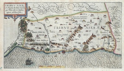
$15.00 Shipping Location: Brooklyn, United States 1590 Adrichem Map of Tribe of Asher. Israel(Western Galilee, Mount Hermon) WE SELL ONLY ORIGINAL ANTIQUE MAPS- NOT REPRODUCTIONS Title: Tribus Aser id ... moreest. Portio illa Terrae Sancta, quae Tribui Aser in diuisione regionis attributa fuit. Description: This is a beautiful example of Christian van Adrichom's rare 1590 map of the lands granted to the Tribe of Asher at the time of Joshua's division of the Twelve Tribes. The map is oriented to the east and covers western Galilee from the city of Acre(called Ptolemais or Acon in ancient times) northward past the city of Tyre(Tyrus) toward Sidon and Mouth Hermon. A number of important biblical sites are identified pictorially including the site of the episode of Saint George and the Dragon where Saint George. The brave martyr, kills a dragon(signifying the devil) to rescue a princess(signifying God's Holy Truth) After the Kingdom of Israel was conquered by Assyria, the northern tribes including Dan, Ephraim, Manasseh, Asher and Zebulun were spared. The tribe of Asher would return to worship at the Temple of Jerusalem. This map is the first of ten maps of the Holy Land prepared by Christian van Adrichem for publication in his Theatrum Terrae Sanctae. Adrichem's maps for the Theatrum were prepared between 1580 and 1585, but were published posthumously by his associate, Gerardis Brunius of Koln, in 1590. The publication went through several later editions and served as a basis for most subsequent maps of the Holy Land well into the 18th century. Size: Printed area measures 9 inches high by 16 inches wide. Condition: Very good. Original platemark visible. Blank on verso. Minor wear along original fold lines. Shipping: Due to recent increases in United States Postal Service rates we have been forced to increase our shipping rates. Shipping rates are not negotiable. Items are shipped within three business days of receiving payment. We are happy to consolidate shipping where possible. The following shipping options are available: 1. USPS Domestic Express Mail(35
Buy It Now
$15.00 Shipping Location: Brooklyn, United States Centered on Turkey, it covers from the Black Sea south to the Nile Delta, depicting the colonies under the Ottoman Empire, including Cyprus, Turkey, Cyprus, ... moreLebanon, Holy Land (Israel / Palestine), Iraq and Syria.
Buy It Now
Free Shipping Location: De Fryske Marren - Langweer, Netherlands 1700 Original item- no modern reprint! Engraving size is CA 460 mm by 390 mm Condition; Fair have no margins( some lost in the plate) Some spots and a ... morelarge repair in the center. PHOTO LOOKS DARK ITEM IS NOT! Shipping is $30* Shipping policy All items may be refund in 14 days afther you recieve the item. If it’s a mistake in the listing I pay all shipping costs if not than all shipping costs is for the buyer. My shipping day is wednesday and saturday. All items paid before that day will be send on that day. If you want something to send a.s.a.p please mail me and I will see what I can do to send it faster. If there is any probleem with the item please contact me first and we will find a way to work it out. Shipping can be delayed by customs. Paymends; Paymend paypal. Bankaccount by bic and iban or giro/ bank in Holland_
Buy It Now
$15.00 Shipping Location: Brooklyn, United States The Holy Land is labeled, and locates both Nazareth and Jerusalem. The Arabian Peninsual is divided into several different regions, although there are ... moretwo dominant labels 'Arabie Deserte ' or 'Desert Arabia' and 'Arabie Heureuse ' or 'Happy Arabia.'.

Buy It Now
$15.00 Shipping Location: Brooklyn, United States 1590 Adrichem Map of the Tribe of Gad. Israel( Sea of Galilee and lands south) WE SELL ONLY ORIGINAL ANTIQUE MAPS- NOT REPRODUCTIONS Title: Tribus Gad ... morenempe. Ca Terrae Sancte pars, quae obtigit in partitione regionis tribui Gad. Description: A fine example of Christian van Adrichem's rare 1590 map of the lands granted to the Tribe of Gad at the time of Joshua's division of the Twelve Tribes. The map is oriented to the east and covers from the Sea of Galilee and the River Jordan eastward into modern day Jordan as far as Nabataea. A number of important biblical sites are identified pictorially including the Saltus Ephraim or Ephraim Forest where the fatal battle between the armies of David and Absalom(2 Sam xviii. 5) was fought, and the site of the prophet Balaam's meeting with the Angel of God(Numbers 22-24) Gad was part of the Kingdom of Israel until its lands were conquered by Assyria in c. 723 BC and the population deported. Since that time it has been considered one of the Ten Lost Tribes of Israel. This map is the third of ten maps of the Holy Land prepared by Christian van Adrichem for publication in his Theatrum Terrae Sanctae. Adrichem's maps for the Theatrum were prepared between 1580 and 1585, but were published posthumously by his associate, Gerardis Brunius of Koln, in 1590. The publication went through several later editions and served as a basis for most subsequent maps of the Holy Land well into the 18th century. Size: Printed area measures 10 inches high by 17.5 inches wide. Condition: Very good condition. Original platemark visible. Shipping: Due to recent increases in United States Postal Service rates we have been forced to increase our shipping rates. Shipping rates are not negotiable. Items are shipped within three business days of receiving payment. We are happy to consolidate shipping where possible. The following shipping options are available: 1. USPS Domestic Express Mail(35 USD) USA Only. 2. USPS Priority Mail(15 USD) USA Only. 3. USPS International Express(35 to 55 USD)
Buy It Now
$22.57 Shipping Location: DEAL, United Kingdom Reproduction Map of Jerusalem circa 1650 by Thomas Fuller on Matt Poly Canvas size 17" x 17" including a 1" border.
Buy It Now
$9.99 Shipping Location: Ivanhoe, Australia It contained 250 lithographs by Louis Haghe of Robertss watercolor sketches. William Brockedon and George Croly wrote much of the text, Croly writing ... morethe historical, and Brockedon the descriptive portions.
|
|
|
|
Original Steel Engraved Map Antique c1840 PALESTINE ISRAEL HOLY LAND JORDAN
PALESTINE. ISRAEL,HOLY LAND original antique hand coloured map c1840, PALESTINE. ISRAEL,HOLY LAND original antique hand coloured map c1840 PALESTINE Drawn& Engraved by J.Gellatly Published Edinburgh circa 1840 by W.R.Chambers A mid 19th century steel engraved map of Palestine. Covering present day Israel and Lebanon, with parts of Jordan and Syria. Enhanced with attractive later hand colouring. A few isolated spots of browning otherwise fine condition. Blank verso. Approx. 10" x 8" 250mm x 210mm) map area only. With good margins beyond on a medium grade paper. NMC113 A GENUINE ANTIQUE MAP GUARANTEED OVER 300 YEARS OLD FROM LINDISFARNE PRINTS We do not deal in reproductions. Facsimiles or modern copies of any kind. SHIPPING Within UK- £2.95 via Royal Mail First class. Europe- £3.95 via Royal Mail Airmail. USA and rest ... moreof the world- £4.95 via Royal Mail Airmail. Closeups, Shipping Process, Two items are always combined for shipping and three items or more are shipped free of charge. Worldwide"Please see item description for postage costs" Payment Options, All major Credit and debit cards via PAYPAL. Personal cheque drawn on UK banks only. Postal Orders from UK post offices only. Bank transfer- please email for details. About Us, Lindisfarne Prints is a small family business specialising in genuine antique maps and prints at affordable prices.Established in 1995 and trading online since 2000. We pride ourselves on accurate descriptions, good communications, rapid service and fair prices. We are proud to maintain a 100% positive feedback rating which we hope reflects this.To avoid confusion, no item less than 100 years old is ever offered for sale. We do not deal in reproductions, facsimiles or modern copies of any kind. So please buy with confidence in the safe knowledge that authenticity is unfailingly assured. Return Policy, Customer satisfaction is paramount and any item not exactly as described will be accepted for return. Without hesitation. The buyer is responsible for se
|
|
|
Antique 1877 Holy Land Bible Map Set/Lot 15~Palestine,Jerusalem,Canaan,12 Tribes
~*~ WELCOME TO ~*~ ~ KARIZMA'S KLOSET! ~ Personalized Service with FAST Shipping! Set of(15) Small Maps from an Antique 1877 Bible ~ Jerusalem ~ Canaan ~ Sea of Galilee ~ Palestine ~ Etc! ~ small size just 4 1/2" x 7" I removed these from a damaged antique 1877 Bible there are faint water marks along the bottom 1" thought they might make neat framed decor or great for paper arts and crafts projects! ENJOY! Thanks for stoppin' and shoppin' Kari:o) FAST SHIPPING! I know when I buy something I want it as quickly as possible. So I assume you do, too! Therefore. FAST shipping is a TOP PRIORITY! Upon receiving your cleared payment your item is carefully packaged up and shipped out within 48 hours. If for some reason there is a delay, I will email you. A DAILY run to the post office is made every M-F(usually in the mornings ... moreso payments received after 6pm are treated as next day sales) Since our PO is closed on the weekends. Items paid for on Friday, Saturday and Sunday are shipped out the following Monday. Combined S/H Discounts: On MOST items(excluding free shipping- which is free! Or unless otherwise noted under the‘shipping and payments’ tab) I follow the standard practice of adding $1 for each additional item purchased based on the highest s/h charge shown. If the total weight of the items bumps the package into the next USPS weight tier. Then I use that cost+handling+$1 for each item. I am ALWAYS happy to provide a quote prior to your purchase, too! My eBay: I LOVE what I do and the customers I serve! EBay is my full-time job. And I dedicate the following times to making it a great experience for you: M-F from 10am to 6pm. I check emails frequently and try to reply the same day! I take Saturdays and Sundays off to be with my family and to honor and serve our Lord and Savior Jesus Christ. I thank you in advance for respecting my time as much as I respect yours! God bless and thank you so much for stopping by! Ecclesiastes 3:1“There is a time for everything. And a season for every activity
|
|
|
ANTIQUE MAP OF THE HOLY LAND OF ISRAEL FROM 1614
ANTIQUE MAP OF THE HOLY LAND OF ISRAEL FROM 1614 THE MAP HAS SOME TEARS*MAP WILL BE SENT BY EMS SPECIAL. SECURED SHIPPING 336.RcmdId ViewItemDescV4,RlogId p4%60bo7%60jtb9%3Fvo%7B%3Dd70f%2B%3E336-147542190e1-0x113-
|
|
|
HOLY LAND JUDEA ISRAEL PALESTINE JORDAN ORIENT ENGR. MAP SEUTTER 1750 #B313
MORE HISTORY SEUTTER COPPER ENGRAVING MAPS IN OUR AUCTIONS! WEITERE HISTORISCHE SEUTTER KUPFERSTICH KARTEN IN UNSEREN AUKTIONEN! Rare! Original and Decorative old-coloured copper engraving map out of"Atlas minor" by Matthaeus Seutter. Printed in Augsburg about 1750 AD map of the Holy Land- Judea- Jordan"Terra Sancta. Cartographer& Publisher: Matthaeus Seutter( 1678 in Augsburg; 1757) German cartographer and engraver. Description: We offer a decorative and old coloured copper engraving map by Matthaeus Seutter. This interesting map shows the Holy Land- Israel- Palestine and Jordan as well adjacent areas of Sinai and Syria. The map is decorated with a beautiful title cartouche. Decorative and beautiful collection item! Size: Leaf app. 29.5 x 22,6 cm engraving app. 26.0 x 19,7 cm Condition: very good condition strong print& ... morebeautiful old-colour age-according marginal stained and brownish Map mounted on old handmade paper. Please have a look at the pictures! Please note all items auctioned are genuine. We do not sell reproductions. A Certificate of Authenticity(COA) can be issued on request. Selten! Originale und Dekorative altkolorierte Kupferstich Karte aus dem"Atlas minor"von Matthäus Seutter. Gedruck tin Augsburg um 1750 AD Karte vom Heiligen Land- Judea- Jordanien" Terra Sancta. Kartograph& Verleger: Matthäus Seutter(auch: Matthias Seutter) 1678 in Augsburg; 1757) Deutscher Kartograph und Kupferstecher, Gründer der Druckerei und des Verlages Seutter. Beschreibung: Wir bieten Ihnen eine dekorative und sehr schön altkolorierte Kupferstich Karte von Matthäus Seutter an. Diese interessante Karte zeigt das Heilige Land- Israel- Palästina und Jordanien sowie die angrenzenden Gebiete von Sinai und Syrien. Die Karte ist dekoriert mit einer schönen Titelkartusche. Sehr dekoratives und wunderschönes Sammelobjekt! Maße: Blatt ca. 29.5 x 22,6 cm Kupferstich ca. 26.0 x 19,7 cm Zustand: sehr guter Zustand kräftiger Druck und schön
|
|
|
Lot of 4 Shot Glass Sea of Galilee Map Jesus Miracles, Christian Holy Land Gift
LOT 4"SEA OF GALILEE" Shot/ Wine Glasses. Souvenir from Israel the Holy Land This shot glass contains an illustrated Sea of Galilee Map- Kinneret lake with all its important and holy places like Tiberias. Tabgha and more Lovely souvenir. Cheers! Size( H x W) 2.3 x 2 inch/ 6 x 5 cm Quoted from Wikipedia: Much of the ministry of Jesus was on the shores of Lake Galilee. In those days. There were many settlements and villages all around the lake and plenty of trade and ferrying by boat. The gospels of Mark(1:14-20) Matthew(4:18-22) And Luke(5:1-11) tell how Jesus got four of his apostles from the shores of Lake Galilee: the fishermen Simon and his brother Andrew. And the brothers John and James. One of Jesus' famous teachings. The Sermon on the Mount. Was given on a hill overlooking the lake. Many of his miracles were also recorded ... moreto have been here: his walking on water, calming a storm, feeding five thousand people and many others Normal 0 MicrosoftInternetExplorer4_ Feel free to email us with any question Liorel. Art from Israel Find a special gift Unique art works& gifts. Handmade by Israeli artists Vintage antiques& collectibles from the early days of Israel_ Ordering& Shipping Information Shipping Worldwide from Israel. All orders are insured for loss or damage Shipping Options: Express. Standard and Sea mail. By default. Parcels up to 2 kg will be sent by standard Airmail and over 2 kg by Express mail. Shipping by sea is cheaper and takes over a month, please contact us for a quote Shipping Time(to most places in the world) Standard mail: 7-14 business days(1-2 weeks) Express mail: 4-5 business days. Sea Mail(Economy) 1-2 months Shipping Enquiries: Delivery depends on the mail services of your country and delivery times of up to one month can occur in few cases(like holiday times or distant locations) Please contact us if you didn’t receive your order within 4 weeks
|
|
|
1865 Original Lithograph Map of Holy Land by Justus Perthes, Germany
Spectacular original German map of Holy Land. Helligen Landes" Lithographed by Justus Perthes. May 1865, showing the coast from Sidon or Saida to Athlit, including Haifa and the Bay of Acre. This is the area known as Galilee and Phoenicia. This map is approx. 18.5 inches by 15 inches in size, with old fold marks. It's in a spectacular shape for a 150-year-old map. A rubber stamp at lower left is hard to decipher. Map will be folded for shipping.
|
|
|
National Geographic Maps [2] - 1961 Two-Sided Civil War Map & 1963 Holy Land
Very good 1961 National Geographic Two-Sided Civil War Map. Two small tears. All corners and edges are good. The map is not brittle and evidences little if any fading. Shows primary offensives, battles, maneuvers, raids, political actions, major spy operations, and most everything short of skirmishes. Separate mapping and insets for Gettysburg, Fort Sumter, and several major campaigns. The text and dating on the map(s) is an abridged history of the Civil War in and of itself. Very good 1963 National Geographic Map of the Holy Land Today. No rips nor tears, all corners and edges are good. The map is not brittle and evidences little if any fading. Map identifies historical events covering a 2800-year period of time. Nice inset of the Walled City of Jerusalem.
|
|
|
Vintage 1973 Historical Map Israel Holy Land Judaism Jewish Biblical Sinai Pub.
This is a 1973"Historical Map of the Holy Land For Biblical Research: The Rise and Fall of Israel and Judah" From 3000 BC to 738 AD. By Sinai Publishing. Measures 17 1/2" x 28" The map is colorful and there is a synopsis of"the most important historical events of the old testament" along the edge and on the back. Very little wear. Has been in a storage box. This is a folded map. Please feel free to email me with any questions. Thanks for looking and good luck bidding!
|
|
|
1752 map of Palestine An accurate of the Holy Land Divided into the XII Tribes
frame not included) Map Description: 1752 map: An accurate map of the Holy Land Divided into the XII Tribes of Israel. Accomodated to Sacred History. describing the Travels of Jesus Christ. Size: Approximately 2 foot x 18 inches. 61cm x 46cm) Archival Quality Reproduction Close up of Map Quality: Shipping: Tracking Number& Insurance included with all domestic orders Packaging: heavy duty poster tube. END FOOTER/
|
|
|
ISRAEL HOLY LAND PALESTINE REGIONS JERUSALEM JORDAN ENGR. MAP WEIGEL 1720 #B336
MORE ORIGINAL HISTORY WEIGEL COPPER ENGRAVING MAPS IN OUR AUCTIONS! WEITERE ORIGINALE HISTORISCHE WEIGEL KUPFERSTICH KARTEN IN UNSEREN AUKTIONEN! Original and Decorative old-coloured copper engraving map of Christoph Weigel. Published by Johann David Köhler, Nuremberg, about 1720[Out of: Descriptio orbis antiqui. Splendid map of Palestina- Holy Land- Israel"Conspectus Palaestinae. Cartographer/Publisher: Christoph Weigel(1654-1725) was an German engraver. Art dealer and publisher. In addition of the Homann publishing house produced Weigel small maps and atlases. Johann David Koehler(1684-1785) Description: We offer a beautiful and old-coloured copper engraving map out of the work"Descriptio orbis antiqui. of Christoph Weigel the first Atlas edition from 1720. This interesting map shows Holy Land/ Palestina in 4 parts as well ... moreas the adjacent areas. The map is decorated with a nice cartouche. Decorative and rare collection item! Size: Leaf app. 37.2 x 45,5 cm Map app. 29.7 x 36,5 cm Condition: in good condition good strong print& paper marginal stained Please have a look at the pictures! Please note all items auctioned are genuine. We do not sell reproductions. A Certificate of Authenticity(COA) can be issued on request. Combine shipping is possible with only 1x calculated shipping cost! Originale und Dekorative altkolorierte Kupferstich Karte von Christoph Weigel. Herausgegeben bei Johann David Köhler, Nürnberg, um 1720[Aus: Descriptio orbis antiqui. Prächtige Karte von Palästina- Heiliges Land- Israel"Conspectus Palaestinae. Kartograph/Herausgeber: Christoph Weigel(1654-1725) war ein deutscher Kupferstecher. Kunsthändler und Verleger. In Nürnberg arbeitete Weigel bei der Anfertigung seiner Landkarten sehr eng mit dem kaiserlichen Geographen und Kartografen Johann Baptist Homann zusammen. In Ergänzung zum Homannschen Verlag produzierte Weigel kleinformatige Karten und Atlanten. Johann David Koehler(1684-1785) Beschreibung: Wir bieten Ihnen eine schöne
|
|
|
Vintage National Geographic Map of Holy Land Today Dec 1963 History Israel Gaza
This is a National Geographic Map of the Holy Land Today with"today" being December of 1963. Of course the borders have changed many times since then. So this is not just a history lesson it was a moment in time. The map includes insets of the Middle East with the Mediterranean. And the walled city of Jerusalem. The map contains many many historical references as well as biblical references. There is so much text on this map that it is like getting a history book along with a pictorial map. With all of the news now. The map is a great reference piece for following along what is going on in this area. It is pristine. And frameable. This map is in mint condition- no tears. No rips, no yellowing. It measures when open 19 inches across 24 inches tall. When folded it is 9.5" by 6" I accept PayPal and ship to the USA
|
|
|
1736 - BUFFIER - Small map TURKEY in ASIA SYRIA HOLY LAND CYPRUS ARMENIA
Scroll down for full screen images You are bidding on a small ORIGINAL 18th century foldout map* Title- Turquie en Asie ancienne et moderne. Author- Buffier Engraver- Source- Buffier- Géographie Universelle- 1736- Technique Copperplate engraved map Paper Thin and strong Color Recent hand coloring* Dimensions of the printing Inches 5 1/2 x 6 3/4 cm 14 x 17.5 plus margins Condition Exc ellent. Dark impression. Shipping/ handling Priority airmail USA. Americas, Asia $3.50(approx. 7 days) European Union $2.50(approx. 3 days) Optional registration $6.00 I will combine shipping for multiple purchases
|
|
|
1624 ORTELIUS MAP OF HOLY LAND - 22 border vignettes the life of Abraham
Abrahami Patriarchae Peregrinatio et Vita. Abrahamo Ortelio Antverpiano auctore. Extremely decorative and famous map of Holy land surrounded by 22 medallion depicting scenes from Patriarch Abraham's life from his departure from Ur to his death. Inset with a small map of the Middle East from the Mediterranean to the Euphrates River. Ortelius designed. And probably also engraved this beautiful Holy Land. From the 1624 final edition by Balthasar Moretus of the first historical atlas ever published. Ortelius’s Parergon began as a companion to his Theatrum but eventually it became an independent work. In fact. This collection of maps of the ancient world was so significant that it became the model for all historical atlases published throughout the seventeenth century. The maps and plates in the Parergon have to be evaluated as the most outstanding ... moreengravings depicting the wide-spread interest in classical geography in the 16th century” Koeman) Unlike the Theatrum. Which consisted of existing maps reengraved by Ortelius, the maps in the Parergon were drawn by Ortelius himself. As a scholar of antiquity. A dealer in antiques, and a visitor to ancient sites, he was well prepared to execute the maps and all the maps from the Parergon reflect his passion for the ancient world. Original Please ask me for more photos or info about shipping/payment. Dimensions: copperplate) 355 x 460 mm- The full leaf 470 x 570 mm Contition: Strong stable paper. Lightly age toned. Dark impression. A couple of light spots at top near the title cartouche. Never washed. Pressed or with modern colors added. Overall in good condition. All of the maps we sell are Originals. Authentic and in Good condition. Payment via bank transfer, Paypal or Visa/MC. Please email me for any question or photos.
|
|
|
Special Places of the World The Holy Land 1989 National Geographic Folded Map
Minor wear. I will not be unfolding them to get measurements. Buy as is. FREE LOCAL DELIVERY ON SALES TOTALING $15 OR MORE IN ST. JOHN'S/MOUNT PEARL AREA. ITEMS WILL BE DROPPED IN YOUR MAILBOX WITHIN 48 HOURS OF RECEIVING PAYMENT. BUYERS FROM AREAS CLOSE BY SHOULD CONTACT ME. I MAY BE ABLE TO OFFER FREE DELIVERY TO YOUR AREA. I only sell older used items. I accept PAYPAL. Feel free to contact me. I DO COMBINE S/H FOR MULTIPLE ITEMS. YOU WILL HAVE TO WAIT FOR or request MY INVOICE(not the end of auction email from ebay) TO GET THE LOWEST SHIPPING COST WHEN BUYING MULTIPLE ITEMS. Item Location: Maps Box 1. Item# 65(2)
|
|
|
FIRST WORLD MAP PRINTED MER HISTORIES ILLUSTRATED 1543 HOLY LAND MAP BIBLE
LE MER DES HISTORIES L]e premier volume || de la mer des histoires. || Auquel& le second ensuyuãt || Est contenu tant du vieil testament que du nouueau toutes les || Hystoires/ Actes et Faictz dignes de memoire/ puis la || creation du Monde iusques en lan Mil cinq || cens. xliii. selon la cotte& datte des ans[LES ANGELIERS frame] 1543 COLLATION LARGE FOLIO 33 cm(13 inch) FIRST BOOK[12] I-CCLVIII. SECOND BOOK[4] I-CCIV. 19th century binding. Leather spine with marble boards. CONDITION A very pleasing clean copy. A few small tears in some of the pages. Worldmap is in perfect condition(40 cm x 32.5 cm) The Holy map is slightly trimmed on the left and the right side. CONTENT This is an illustrated historical encyclopedia in Latin. One of the earliest printed universal chronicles. The Rudimentum Novitiorum as the work is called in ... moreLatin, was first printed in Lübeck by Lucas Brandis as his most ambitious work. It runs to 475 pages, richly illustrated with more than 150 woodcuts. The account starts with the creation of the world and ends with the year 1473, with the usual subdivision into the six aetates. It presents a synopsis of Christ's ancestors, of Jewish high priests, judges and Biblical rulers and of Roman Emperors It was printed in French. In 1491 and is considered one of the most extensively illustrated French incunables. La Mer des histoires( A sea of stories) This Rudimentum combines secular and ecclesiastical history, ancient history and pagan mythology; twenty-nine Aesop's Fables are incorporated into the"Fifth Age" The French translation contains additional material on the kings of France and is accompanied by a martyrology by Usardus. In Latin edition the world map is identical. Only much bigger in size, making it more valuable. The 1475 edition sold over 1 miljon dollars. THE MAPS This French edition was printed in 1543. It contains. The worldmap and the map of the Holy land, and is complete. Numerous woodcut illustrations in text, one full-page, one of the crucifixion
|
|
|
1850 - Palestine Israel Holy Land Jordanien Arabia Stahlstich map Karte
Wir kaufen alte Bücher und Grafik- komplette Nachlässe oder wertvolle Einzelstücke(GN 25671) Palestina" orginal Stahlstich von ca. 1850 Blattmasse ca. 30 x 25 cm aufgrund der Blattmasse können wir die Karte nicht mehr als Büchersendung versenden- Versandkostenn innerhalb Deutschland deshalb 5. EUR als Paket im Außenrand gebräunt. Leicht fleckig, althinterlegt sonst gut erhalten_ Original! Kein Nachdruck! Keine Kopie! Vorauskasse. Der Käufer trägt die Versandkosten. Ab einem Warenwert von 29.99 EUR versenden wir auch innerhalb Deutschland als versichertes Einschreiben oder DHL Paket. Viele alte Bücher. Landkarten, Ansichten und Portraits in unserem ebay-shop. Plus de gravures dans notre ebay-shop. More views. Maps, portraits and coat-of-arms in our ebay-shop! Erstellt durch Das kostenlose ... moreEinstell-Tool. Stellen Sie Ihre Artikel schnell und bequem ein und verwalten Sie Ihre aktiven Angebote.
|
|
|
Tribuum EPHRAIM BENIAMIN ANTIQUE MAP Holy Land by Georgius Hornius 1650
Title: Tribuum EPHRAIM BENIAMIN et DIMIDIAE MANASSE intra Iordanen partes occidentales et partes Septentrionalis DAN et LUDA. Hand colored copperplate engraving of the Holy Land bij Georgius Hornius. The map depicts the Biblical old places with illustrations what references to the Bible. The half-tribe of Ephraim, Manasseh, Benjamin, Jonas and the whale and numerous warriors and soldiers. ORIGINAL ANTIQUE COPPER PLATE ENGRAVING. HAND COLORED. Engraving is Absolutely Guaranteed authentic original map. A Certificate of Authenticity will be on request forwarded for each individual map or print. Image app: 35.5 x 28 cm. 13.75 x 10.75 inches. Condition: More than 350 years old map with good view anywhere. Split and some weakness in lower center fold, lower right corner restored, borders with small cracks. All maps and prints are genuine. Authentic, ... morepublished at the date stated in this listing! For better quality pictures please go to our web site: WWW.MAPANDMAPS.COM I offer a no questions returns policy. All maps and prints are genuine. Authentic, published at the date stated above. Worldwide shipping by signed registered mail or Global Express courier. Shipping: Worldwide shipping by signed registered mail or Global Express courier. Standard Int'l Shipping means registered airmail of Europe. If you want to receive the item quickly. Ask for Expedited Int'l Shipping or a 3 days Shipping by FedEx. between $ 25.95 and $ 38.50) Shipping fee is per combined shipment. Including handling and insurance. Free shipping worldwide if three items or more purchased.
|
|
|
1831 Palmer Map - Canaan or Holy Land - Israel Jeruslem - Hebrew Old Testament
Lake Erie Maps and Prints See Our Ebay Store for other Holy Land Maps An Authentic Antique Map: Not a Modern Reproduction No Additional Postage on Multiple Maps Shipped with the First Description: It is an authentic engraved antique map over 172 years old with original hand coloring as issued. It is designed by Richard Palmer as stated in the bottom right margin and the publishing info is in the bottom center. It is from the Palmer's The Bible Atlas of Sacred Geography Delineated(London: Baldwin& Cradock. 1831) A facsimile copy of the title page is included for authenticity. The map is not mounted, matted nor framed, being sold as a single sheet as seen in the main pic. Overall, a very nice rare map with original hand color that would frame up nicely. Size: The map image measures. From neat line to neat line, approximately 6 by 7 ... moreinches(15x18cm) and is on a 8 by 9" 20x22cm) page as seen in the pic with a wide margin all around for framing as seen in the main pic. Condition: The map is in Good condition with overall tonal ageing. Blank on the reverse, printed on a strong buff paper with a centerfold as issued. There are a couple of light spots and some light backprinting as seen in the pics, see the pics for more on condition. The pics are accurate of the actual map. Payment Details: We accept most major credit cards through Paypal. Please ask if you have any questions about payment. International Bidders are welcomed and encouraged. Payment is expected within 7 days. Nonpaying Bidders will be reported to Ebay to recoup our listing fees. International Customs and VAT Fees: It is the responsibility of the buyer to pay all Customs Taxes. VAT or other fees that may be due upon arrival. These fees vary greatly from country to country and ebay policy is that the buyer is responsible for their country's taxes and fees. Please consult your country's Customs Regulations for more details on your country, printed matter is duty free in many countries. We declare the full purchase value as required by la
|
|
|
Origina lAntique Map ISRAEL, SYRIA, CYPRUS, HOLY LAND, Mallet 1719
ISRAEL. SYRIA, CYPRUS, HOLY LAND, Mallet original antique map 1719, ISRAEL. SYRIA, CYPRUS, HOLY LAND, Mallet original antique map 1719 SYRIE ANCIENNE by Alain Manesson Mallet. Published Frankfurt 1719 in"Beschreibung des ganzen Welt Kreises. A German translation of Mallet's"Description de L'Univers. A copper engraved antique map of present day Syria. Israel, Lebanon, Jordan, Palestine, Cyprus etc. Fine condition. Free of repairs or restoration on hand laid paper. Blank verso. Approx. 5.5" x 4" 140mm x 110mm) printed area only with good margins beyond. ALLAIN MANESSON MALLET(1630- 1706) Mallet started out as a soldier serving King Louis XIV as an inspector of fortifications but later was appointed as mathematics teacher at the King's court. He is chiefly remembered however for his publications of" Description ... morede L'Univers" 1683) in 5 volumes. And"Les Travaux de Mars ou l'Art de la Guerre" 1684) in 3 volumes. A GENUINE ANTIQUE MAP GUARANTEED OVER 290 YEARS OLD FROM LINDISFARNE PRINTS T82614 We do not deal in reproductions. Facsimiles or modern copies of any kind. Two items shipped for a single postage charge. Free shipping worldwide if three items or more purchased Closeups, Shipping Process, Two items are always combined for shipping and three items or more are shipped free of charge. Worldwide"Please see item description for postage costs" Payment Options, All major Credit and debit cards via PAYPAL. Personal cheque drawn on UK banks only. Postal Orders from UK post offices only. Bank transfer- please email for details. About Us, Lindisfarne Prints is a small family business specialising in genuine antique maps and prints at affordable prices.Established in 1995 and trading online since 2000. We pride ourselves on accurate descriptions, good communications, rapid service and fair prices. We are proud to maintain a 100% positive feedback rating which we hope reflects this.To avoid confusion, no item less than 100 years old is ever offered for sa
|
|
|
Mitchell's Antique ~ "A New Map of Palestine or The Holy Land" ~1864~ Jerusalem
Beautifully hand colored"A New Map of Palestine Or The Holy Land" by one of the most prominent map publishers of the times. S. Augustus Mitchell, dated 1864. This unique map illustrates the geography as defined at the time. Large inset map of"Modern Jerusalem" This historically significant. Antique map is finely detailed with the characteristic ornate border surrounding many of Mitchell's maps. Printed map area is in good condition. Note the detailed photos showing precise condition of the map- lower left corner missing and right border tears with chunk missing. Priced according to condition. According to a recent 2014 article in CountryLiving magazine. Entitled"What to Collect Now: Antique Maps" this map is notable due to its' decorative value, the major changes of geographic interest, as well as its' ... moreprominent map maker, Augustus Mitchell.see more information regarding Augustus Mitchell below. SIZE: 12 5/8" x 15 3/8" Perfect for the map collector. Or history buff! Please contact me with any questions. Or if you are interested in maps of a different geographic location. Biography of Samuel Augustus Mitchell: For over 50 years. Samuel Augustus Mitchell and his successors were one of the most prominent publishers of maps and atlases in the United States. Augustus Mitchell was born in Bristol. Connecticut in 1792. His father emigrated from Scotland in 1773. While little is known about his early schooling. It is known that Mitchell found the quality of early geography text books to be lacking, and determined that he would write and publish better works. This decision led him to relocate to Philadelphia in 1829 or 1830. Which was then the center of commercial publishing in America. Mitchell’s first cartographic work was the re-issue of Anthony Finley’s New American Atlas in 1831. Issued in serial format from 1818 to 1822 and as a complete work from 1823 onward. Following publication of the New American Atlas. Mitchell began issuing the individual maps in pocket map
|
|
|
Vintage Rand McNally Map – Holy Land 16th Century
An absolutely beautiful vintage Rand McNally’s 1956 reproduction of the 16 th century(1556) Sgrooten-Laiksteen map of the Holy Land engraved by Abraham Otelius and included in his Theatrum Orbis Terranum. The reverse side of the map provides a historical information about its creation. The map was published as a Christmas greeting card consisting of three folds. The map is in great condition(see scans) The image is very crisp. Should make an excellent addition to any collection of old maps. Size: 15 x 21. Map–16 x 14. Shipping: 3.50 media mail or 6.25 priority. I will combine multiple purchases. Same shipping for 3 items. 4-5 items- $5; 6-10 items- $7.00.
|
|
|
1928 Antique PICTURE MAP POSTER Christian HOLY LAND Jerusalem Egypt BIBLICAL HL2
This Auction is for an Unframed MODERN REPRINT of an Antique Map as detailed below. This map is reproduced on specially coated. Matte finish, paper for sharper print quality and colors that are vivid. These maps are created from VERY high resolution uncompressed TIFF files(averaging 200+ megabytes) and are much sharper that the image shown here. Description The picture map of the Holy Land. Designed and drawn by Harold Haven Brow. Published by R.R. Bowker Company. 62 West 45th St. New York, Copyright 1928. insets) Jerusalem and its environs. Jerusalem. Profile view of Palestine showing relative height and position of important localities. Map of Palestine showing heights of land thus: Yellow, 0-500 ft; Purple, 500-1500 ft; 1500-300 ft; Pink, over 3000 ft. Black, below sea level. Approximate Image Size 16.5 X 22.5 Inches, Original Atlas Title ... moreN/A, WE HAVE MANY HISTORIC MODERN REPRINT MAPS AND OTHER ITEMS ON MANY DIFFERENT SUBJECTS Please check out store for additonal products FREE SHIPPING BY MAIL(GENERALLY 2 TO 5 DAY DELIVERY) FOR ANY NUMBER OF MAPS SHIPPED IN THE US. SHIPPING IS $15 PLUS $1 FOR EACH ADDITIONAL MAP TO ANYWHERE ELSE IN THE WORLD. WE SHIP ALL MAPS ROLLED IN A MAILING TUBE TO PROTECT THE MAP. IF YOU ARE UNHAPPY WITH YOUR PURCHASE SIMPLY RETURN IT AND WE WILL REFUND YOUR MONEY. Ad copyright 2014 All Rights Reserved Powered by The free listing tool. List your items fast and easy and manage your active items.
|
|
|
Original 1878 Engraved Antique Map EARLY APOSTLES Bible History HOLY LAND
Fine Adornment of Bible History. Impressive on Any Home of Office Wall. Imaginative& Creative Gift. 1878 Map of Early Apostolic History Shows Saul's Journey& Barnabas' Journey. Fascinating Study. Intricate Engraved Detail. Original 1878. 136-yrs-old. Map is in Good/Very Good Condition: No folds. Writings, or marks. Mild foxing. Nominal fraying. Not a Reproduction. Original Map Drawn& Engraved for the 1878 Edition of The Bible Atlas. A Manual of Geography and History, Especially Prepared For the Use of Teachers and Students of the Bible, and For Sunday School Instruction, Illustrated with Accurate Views of the Principal Cities and Localities Known to Bible History, Authored& Edited by J.L. Hurlbut, D.D. with an Introduction by Reverend John H. Vincent, Chancellor of the Chautauqua University; Rand McNally, Engravers. ... morePublished by Harper& Brothers, New York, 1878; a copy of the Title Page of which is Included. An Exceptional Map for Bible History or Makes Quite an Impressionable Gift. I Sell Only Original Maps: No copies or reproductions. Press Here to View My Collection. Impressive on Any Home or Office Wall Dimensions: 9.5" x 11.5" Fine Adornment of Bible History. Beautiful Color. The Auction is for the Map itself. A Frame is Not Included. The Framed Map Pictured is a Personal 1873 Map Featured to Show the Beauty of the Maps when Framed. Free Shipping Special(within the USA) All credit cards. Debit cards, and electronic checks accepted through Paypal. Maps are mailed within 1-3 days of payment and normally arrive within 3-5 days. Please email with any questions. Imaginative& Creative Birthday. Christmas, or Special Occasion Gift. Greetings from Historical Savannah. Georgia; founded 1733. Some. To beautify their halls, studies, galleries, or libraries.loveth, getteth, and useth maps, charts, geographical globes. John Dee. Advisor to Elizabeth I. Press The Link Below To View My Collection. Powered by The free listing tool. List your items fast and easy and manage your activ
|
|
|
Israel - Palestina - Holy Land 1849 MEYER Original detailed map. Inset Jerusalem
Palaestina Lovely very detailed original steel engraved map based on the cartography by C. Franz Radefeld(1788-1874) showing Israel and Palestina. Inset plan of Solomon's Temple and Jerusalem. From the"Meyer's Neuester Zeitungs Atlas" published by Bibliographischen Instituts in Hildburghausen in 1849-1852. The innovation of this work is that many maps had small inserts showing richly detailed maps of major cities and their surrunding areas: so not only could travellers carry the atlas with them easily. They could also obtain an initial orientation to their destination when they arrived. No other atlas offered anything like this. All the maps in this atlas are superbly engraved with fine colouring by hand. All combining to make this the finest"quarto" German atlas of the mid 19th century. Jurgen Espenhorst- Petermann's ... morePlanet- Guide to the great handatlases" 3.1.1* Strong white paper. In very good condition. Size of the map: 185 x 250 mm- Full leaf: 310 x 250 mm* Original We combine shipping Please email me for any question or photos. All of the maps. Prints and artwork on paper we sell are Originals, Authentic and in Good condition. Payment via bank transfer or paypal 643.RcmdId ViewItemDescV4,RlogId p4%60bo7%60jtb9%3Feog4d71f%2B%3E643-147f4db1a4f-0x119-
|
|
|
ANTIQUE MAP - 1717 - ISRAEL - HOLY LAND - ASIA - Sanson - 1717
iscra antique maps& prints'Terra Promissa in suas Tribus partesque divisa' Description: Antique map(later hand coloring) of the Promised Land by N. Sanson D'Abbeville published by Francois Halma. 1717,Leuuwarden. Size: The overall size is 14.5 x 10 inch. The image size is 13 x 8 1/4 inch. Technic: Copper engraving. Condition: Fine; center fold as issued. A Certificate of Authenticity will be added! THERE IS FREE SHIPPING FOR ADDITIONAL ITEMS! Thanks for looking! ISCRA STORE* We accept Paypal payments and Bank transfer payments! Combined orders possibl e! Insurance included! ISCRA- store ISCRA is a member of the international antiquarian map sellers association WE GUARANTEE ITEMS SOLD ARE IN THE CONDITION DESCRIBED. ITEMS CAN BE RETURNED WITHIN 14 DAYS FOR REASONS OF AUTHENTICITY. Powered by The free listing tool. List your ... moreitems fast and easy and manage your active items.
|
|
|
Journey Jesus Christ Judea Holy Land 1734 Moll antique engraved hand color map
A Map of the Journeyings of Our Saviour Jesus Christ Issued 1734. London by Herman Moll Fine original antique engraved map with lovely hand color. Printed on quality handmade paper. As issued, which retains its inherent structural flexibility and soundness. In close to VG[or better] condition: displays normal minor light age toning as typical. Trivial scattered small spotting and light soiling; overall the image remains clean and very attractive- please inspect visual scan closely and note the zoom feature which allows for close inspection[note: we grade very conservatively and always seek to disclose any noteworthy flaws] Great image entirely worthy of an album or hanging for display. A depiction captured in a manner entirely unique to this era. The printed area remains visually pleasing. A nice impression of an interesting map. Any minor ... moredefects along the sheet edges and in the margins may be seen in the photos. Sheet measures c. 9 5/8" W x 7 3/4" H. Engraved area measures c. 7 1/2" W x 6 7/8" H. Original fold lines as issued. Tooleys Dictionary of Mapmakers. V. 3, p. 269* R1272] Guaranteed Authentic! We do not sell modern reprints. Condition: We only handle. Sell& ship original vintage and antique items. Old sheets of paper, printed long ago. Items which are really old, like we say. Not modern copies or modern reproductions. We strive to describe our items accurately. We understand you cannot see it in person. We are trying to present it accurately and convey condition correctly with careful digital photography. Accurate flat-bed scans of the item which are zoomable, precise printed sheet& image sizes and knowledgeable descriptive words. It is important to understand& remember that many old printed paper items survive merely by chance. And all are somewhat unique if you inspect them closely. Few of the same type match exactly if compared side-by-side. Each has it's own characteristics and patina. Sometimes the differences are minor, other times quite noticable. Individual pi
|
|
|
HOLY LAND JUDEA ISRAEL PALESTINE JORDAN ORIENT ORIG. ENGR. MAP HOMANN 1720 #B247
MORE HISTORY COPPER ENGRAVING MAPS IN OUR AUCTIONS! WEITERE HISTORISCHE KUPFERSTICH KARTEN IN UNSEREN AUKTIONEN! Original and Decorative large-size old-coloured copper engraving map. Published by Johann Baptist Homann, printed in Nuremberg about 1720 AD Splendid Map of the Holy Land- Judea- Jordan"Iudaea seu Palaestina. Terra Sancta. Cartographer: Johann Baptist Homann( 20 March 1664 in Oberkammlach near Kammlach. Bavaria; 1 July 1724 in Nuremberg, was a geographer and cartographer, who made atlases and maps. Description We offer a Original and old-coloured copper engraving map by J. B. Homann. This interesting map shows the Holy Land- Israel- Palestine and Jordan as well adjacent areas of Sinai and Syria. The map is decorated with a beautiful coloured title cartouche. The map is a wonderful collection item! Size: Leaf app. 51.0 x 61,2 ... morecm Map app. 49.2 x 57,5 cm Condition: very good condition strong print and paper marginal brownish and stained complete professional restored center fold Please have a look at the pictures! Combine shipping is possible with only 1x calculated shipping cost! Please note all items auctioned are genuine. We do not sell reproductions. A Certificate of Authenticity(COA) can be issued on request. Originale und Dekorative großformatige altkolorierte Kupferstich Karte. Herausgegeben von Johann Baptist Homann, gedruckt in Nürnberg um 1720 AD Prächtige Karte vom Heiligen Land- Judea- Jordanien"Iudaea seu Palaestina. Terra Sancta. Kartograph: Johann Baptist Homann( 20. März 1664 in Oberkammlach. Heute Teil von Kammlach im Landkreis Unterallgäu; 1. Juli 1724 in Nürnberg) war ein deutscher Kartograph. Verleger und Kupferstecher. Beschreibung: Wir bieten Ihnen eine Originale und alt-kolorierte Kupferstichkarte von J. B. Homann an. Diese interessante Karte zeigt das Heilige Land- Israel- Palästina und Jordanien sowie die angrenzenden Gebiete von Sinai
|
|
|
1890 Holy Land Israel Map of Galilee on Mediterranean Color Photo Lantern Slide
This is a photographic glass magic lantern slide. Beautifully colored, labeled, Map Galilee. Galilee is a region in northern Israel which overlaps with much of the administrative Northern District and Haifa District of the country. Traditionally divided into Upper Galilee, Lower Galilee, and Western Galilee, extending from Dan to the north, at the base of Mount Hermon, along Mount Lebanon to the ridges of Mount Carmel and Mount Gilboa north of Jenin and Tulkarm to the south, and from the Jordan Rift Valley to the east across the plains of the Jezreel Valley and Acre to the shores of the Mediterranean Sea and the coastal plain in the west. Magic Lantern Slides are one of the best untapped resources for antique photographs there are. Slides were usually discarded after a relatively short period of use so are difficult to find. Slide is glass ... morewith a cardboard frame and overall size is 3 1/4" x 4" It is in very good condition, and can be viewed by projecting, holding it to the light, or placing it on a light box. This slide can be made into a photograph or poster. If you would like information on having that done AFTER you purchase the view, please let me know. You can learn more about magic lanterns and slides by going to www.magiclanternsociety.org. I offer a reduced postage amount for multiple items IF you email for the cost. Please remember to do this otherwise you will overpay. Thanks for your business, Bob Powered by The free listing tool. List your items fast and easy and manage your active items.
|
|
|
1851 ANTIQUE MAP OF PALESTINA ISRAEL HOLY LAND JERUSALEM LEBANON ISRAELITES
THIS IS AN ORIGINAL MAP. NOT A RECENT COPY OR REPRODUCTION. Origin of the map: Vuillemin. Atlas Universel du Geographie Ancienne et Moderne. edit. J. Langlume, Paris(France) HAND COLOURED Date of issue: 1851 Size: The sheet measures 12" x 9 1/2" 30.5 x 24 cm) S/H: The map will be shipped by Priority International Air Mail. The shipping charge is 7.50 USD( with the tracking number) Or 6.00 USD( without the tracking number) If you wish to save 1.50 USD on the tracking number. Please let me know before you send the payment. Then wait for my invoice. Attention! There is no additional shipping charge for multiple purchases!
|
|
|
1900's Palestina Israel Holy Land Jerusalem Russian Litographic Map Judaica
1900's Palestina Holy Land Jerusalem. Original vintage map. Published by A. Marx. St. Petersburg, Russia. In Russian. Approx. size 280 x 340 mm. C ondition-see scans. DO NOT FORGET TO VISIT MY STORE. Payment. PayPal. C(USD,CAD,GBP,EUR,AUD) Moneybookers, bank transfer(IBAN, BIC) payment in Germany too. S&H by registered mail with tracking nr. $ $5. Combined shipping.
|
|
|
Lattre Bonne Large Decorative Map of Israel Holy Land 1787
O riginal engraving from: Lattre: Atlas moderne. Published: 1787 Sheetsize: approx. 52 x 36 cm Condition: please see photo Shipping-costs: see description. We combine shipping at no extra cost, if more than one item is bought 40g.RcmdId ViewItemDescV4,RlogId p4%60bo7%60jtb9%3Fuk%601d72f%2B%3E40g-14814090531-0xe6-
|
|
|
ANTIQUE MAP - 1699 - JERUSALEM - HOLY LAND, ISRAEL, Lamy, Bernard
iscra antique maps& prints'L'Ancienne Ville de Jerusalem et les environs Description: Antique plan of Jerusalem by Bernard Lamy Source: Introduction a l'Ecriture Sainte' by Bernard Lamy Technic: Copper engraving with hand coloring. Size: The overall size is 16.5 x 14,5 inch. The image size is 15 x11 inch. Condition: Very Good A Certificate of Authenticity will be added! THERE IS FREE SHIPPING FOR ADDITIONAL ITEMS! Thanks for looking! ISCRA STORE* We accept Paypal payments and Bank transfer payments! Combined orders possibl e! Insurance included! Because of different configurations of monitors colours can appear a bit different on you screen. The sizes of the pictures are(most of the time) not the real print size. The real sizes are noted in the description area. A3233 WE GUARANTEE ITEMS SOLD ARE IN THE CONDITION DESCRIBED. ... moreITEMS CAN BE RETURNED WITHIN 14 DAYS after delivery or pick-up date Powered by The free listing tool. List your items fast and easy and manage your active items. g63.RcmdId ViewItemDescV4,RlogId p4%60bo7%60jtb9%3Feog4d71f%2B%3Eg63-148140fc15f-0xfb-
|
|
|
ANTIQUE MAP - 1734 - ASIA MINOR - CYPRUS - HOLY LAND - SYRIA - Tirion - 1734
iscra antique maps& prints'Nieuwe Kaart van Irak Arabi. Kurdistan,Diarbek,Turkomania,Syrie en het Heilige Land' Description: Antique map of the Middle East(Holy Land. Syria, Irak Arabia, Kurdistan and Turlomania) engraved by J. Keyser(dated 1732) published by Isaac Tirion, Amsterdam Technic: Hand colored(later date) copper engraving. Size: The overall size is 14.5 x 11 3/4 inch. The image size is 13,5 x 11 inch. Condition: Very Good; there is a partly short cut left margin( enough for framing- originally cut by the binder) folds as issued. A Certificate of Authenticity will be added! THERE IS FREE SHIPPING FOR ADDITIONAL ITEMS! Thanks for looking! ISCRA STORE* We accept Paypal payments and Bank transfer payments! Combined orders possibl e! Insurance included! ISCRA- store ISCRA is a member of the international antiquarian map ... moresellers association We do the best we can to add clear and reliable pictures. Because of different configurations of monitors colours can appear a bit different on your screen. The sizes of the pictures are(most of the time) not the real print size. The real sizes are noted in the description area. Import duties. Taxes and charges are not included in the item price or shipping cost and are buyer's responsibility WE GUARANTEE ITEMS SOLD ARE IN THE CONDITION DESCRIBED. ITEMS CAN BE RETURNED WITHIN 14 DAYS FOR REASONS OF AUTHENTICITY. Powered by The free listing tool. List your items fast and easy and manage your active items.
|
|
|
ANTIQUE MAP - 1699 - HOLY LAND - ISRAEL - TRIBES - Lamy, Bernard
iscra antique maps& prints'Nouvelle Carte de la Terre Sainte' Description: Antique map of Israel. Showing the divisions of the twelve tribes in the Holy Land. The map showsmany place names and topographical details. A decorative title cartouche. Featuring Moses' spies carrying the fruit from the Promised Land, adorns the map. Source: Introduction a l'Ecriture Sainte by Bernard Lamy Technic: Copper engraving with hand coloring. Size: The overall size is 18 x 14 inch. The image size is 15 x11 inch. Condition: Very Good; some small faint spots(right part below the cartouche) caused by printing(not serious) A Certificate of Authenticity will be added! THERE IS FREE SHIPPING FOR ADDITIONAL ITEMS! Thanks for looking! ISCRA STORE* We accept Paypal payments and Bank transfer payments! Combined orders possibl e! Insurance included! ... moreBecause of different configurations of monitors colours can appear a bit different on you screen. The sizes of the pictures are(most of the time) not the real print size. The real sizes are noted in the description area. WE GUARANTEE ITEMS SOLD ARE IN THE CONDITION DESCRIBED. ITEMS CAN BE RETURNED WITHIN 14 DAYS after delivery or pick-up date Powered by The free listing tool. List your items fast and easy and manage your active items.
|
|
|
1855 Bible Atlas Map - Holy Land Jesus Christ - Palestine Judea Syria Jerusalem
Lake Erie Maps& Prints! An Authentic Antique Map: Not a Modern Reproduction See Our Ebay Store for other No Additional Postage on Multiple Maps Shipped with the First Description: It is an authentic engraved antique map over 160 years old. It is designed by E. Graover as seen in the bottom right margin. It is from the The New Biblical Atlas and Scripture Gazetteer(Philadelphia. 1855) A facsimile copy of the title page is included for authenticity. The map is not mounted, matted nor framed, being sold as a single sheet as seen in the main pic. Size: The map image measures. Between the neat lines, approximately 5 1/4 by 8 inches(13x20cm) and is on a 6 1/4 by 9 1/2" 16x24cm) page as seen in the pic with a wide margin all around for framing as seen in the main pic. Condition: The map is in Fair condition with overall light tonal ageing. ... moreUncolored as issued, blank on the reverse, printed on a heavy buff paper. There are some handling smudges and brown spota as seen in the pics. The pics are accurate of the actual map. Payment Details: We accept most major credit cards through Paypal. Please ask if you have any questions about payment. International Bidders are welcomed and encouraged. Payment is expected within 7 days. Nonpaying Bidders will be reported to Ebay to recoup our listing fees. Satisfaction Guaranteed: We stand fully behind our products and offer a full refund minus shipping with no questions asked. If condition is different than described we offer a full refund including shipping fees. Check out my! Be sure to add me to your! Powered by The free listing tool. List your items fast and easy and manage your active items.
|
|
|
ANTIQUE MAP - 1677 - TRIBES - HOLY LAND - SIMEON - DAN - JUDA - ISRAEL by Dapper
iscra antique maps& prints Tribus Simeon et pars meridionalis Tribus Dan et orientalis Tribus Juda Description: Antique map of the hbitation of the Tribes Simeon. Dan and Juda, by O. Dapper, printed in 1677. This very decorative map shows a lot of details. Among them is the spies return from Canaan Printing date: 1677. Technic: Copper engraving with later hand coloring. Size: The overall size is 14.5 x 12 1/4. There are short margins as issued, but there is enough for framing. Condition: Very Good; partly browning of upper margin. A Certificate of Authenticity will be added! THERE IS FREE SHIPPING FOR ADDITIONAL ITEMS! Thanks for looking! ISCRA STORE* We accept Paypal payments and Bank transfer payments! Combined orders possibl e! Insurance included! Because of different configurations of monitors colours can appear a bit different on ... moreyou screen. The sizes of the pictures are(most of the time) not the real print size. The real sizes are noted in the description area. A3235 WE GUARANTEE ITEMS SOLD ARE IN THE CONDITION DESCRIBED. ITEMS CAN BE RETURNED WITHIN 14 DAYS after delivery or pick-up date Powered by The free listing tool. List your items fast and easy and manage your active items.
|
|
|
ANTIQUE MAP - 1677 - TRIBES - HOLY LAND - EPHRAIM - BENJAMIN- MANASSE - Dapper
iscra antique maps& prints Tribuum Aphraim. Beniamin, et Dimidiae Manasse intra Jordanem partes occidentalis, et partes septentrionales Dan et Juda Description: Antique map of the habitation of the Tribes Ephraim. Benjamin, Dimidia, Manasse, Dan and Juda by O. Dapper, printed in 1677. This very decorative map shows a lot of details and has a wonderfull decorations in lower part. Printing date: 1677. Technic: Copper engraving with later hand coloring. Size: The overall size is 14 3/4 x 12.3 inch. There are short margins as issued. But there is enough for framing. Condition: Very Good A Certificate of Authenticity will be added! THERE IS FREE SHIPPING FOR ADDITIONAL ITEMS! Thanks for looking! ISCRA STORE* We accept Paypal payments and Bank transfer payments! Combined orders possibl e! Insurance included! Because of different configurations ... moreof monitors colours can appear a bit different on you screen. The sizes of the pictures are(most of the time) not the real print size. The real sizes are noted in the description area. A 3234 WE GUARANTEE ITEMS SOLD ARE IN THE CONDITION DESCRIBED. ITEMS CAN BE RETURNED WITHIN 14 DAYS after delivery or pick-up date Powered by The free listing tool. List your items fast and easy and manage your active items.
|
|
|
1756 BUY DE MORNAS HOLY LAND ARABIAN DESERT MESOPOTAMIA ANTIQUE MAP.
See Full Map Description Below Image) This is a genuine antique map. Printed in or about the year listed below. We have been in the antique map business for over 15 years. We do not sell reproductions. Map Maker(s) Buy de Mornas Place/ Date: Paris/ 1756, Coloring: Hand Colored, Size: 24.5 x 14.5 inches, Condition: VG, Description: Decorative historical map of the Holy Land. Part of Cyprus, Mesopotamia and the Arabian Desert. Includes remarkable decorative borders found only in the deluxe edition of Buy De Mornas' Atlas Methodique et Elementaire de Goegraphie et l'Histoire. Terms, If for any reason the item does not match the description item must be returned within 14 days of reception for a full refund. Buyer to pay return shipping cost.
|
|
|
1892 LARGE HISTORICAL MAP ~ HOLY LAND ALLOTTED BY JOSHUA JUDAH REUBEN ZEBULON
A superbly detailed antique map on a single sheet Produced by W& A K Johnston for The Cosmographic Atlas 1892 This scarce map is an original over 120 years old This large single page measures 18 1/2 inches x 14 inches(470mm x 355mm) CONDITION: Please view images to see signs of age/handling There will be another map on the reverse Please message with any questions regarding this item. BEST OFFERS PLEASE FOR A QUICK SALE AT A FAIR PRICE If you like the item. But do not like the price, then make a realistic offer to us using the MAKE OFFER BUTTON. Powered by
|
|
|
1755 Rare Antique Map Holy Land, Syria, Palestine
Title: Carte de la Syrie et de la Phenicie. Date: c1755 By: Unknown Description: Map of the Holy land showing the peoples living in the area before the arrival of the Israelites. Charming map with sailing ships off the coast and many other historical details. Condition: VG. Fold lines as issued. Some age toning& ruffling. Small tears on top edge of map and remnant of small tape mark. Size: 33cm x 31cm ================================================================================= I am a long time collector of antique Maps of China and Asia and have a large number of maps that I will be bringing up for sale. All maps have come from my own private collection- I do not sell any copies or reproductions at all. A Certificate of Authenticity can be issued. On request for any maps bought. I am also a member of the International Map Collectors ... moreSociety(IMCOS) Save my site as a favourite and keep on the lookout for future sales. Thanks, Vince
|
|
|
Antique Map of the Holy Land - Williem Albert Bachiene Amsterdam c1750
Antique Map of the Holy Land- Williem Albert Bachiene Amsterdam c1750 De Landen van't Romeinische Gebied Engraving 395*500m Central vertical fold with repired splitting. Some repired surface loss in margins, surface dirt and minor browning. I try to give as much detail as possible in the photos. Please do not hesitate to ask for more information Returns not accepted. Please consider all details and pictures before bidding to understand what you are buying. Item will be sent in a mailing tube. Carefully packed to avoid damage. Please check out my other listings and happy bidding.
|
|
|
HOLY LAND authentic Antique Map made in 1887 ISRAEL genuine 127 years old
Bird's-Eye View of the Holy Land PALESTINE Authentic 127-Year Old Antique Map Created by: George F. Cram Date: 1887 Size: About 25x34cm. 10x13 inches) Condition: Fine Printed in 1887. This is a beautiful, 127-year-old color topographical map of the Holy Land- primarily Palestine, but including parts of Lebanon, Syria and Jordan. This map measures about 10 by 13 inches(about 25 by 34 cm. and is in Fine condition. This map is very detailed, showing topographical features, towns and villages, purported tombs of Biblical patriarchs and more. Terrain elevations and drainage are indicated using hachures, as was customary in Victorian Era cartography. There is a list of over 250 points of interest mentioned in the Bible, all keyed to the map. This is a guaranteed genuine antique map! Besides being highly decorative. It is ideal for genealogy ... moreand other historical research. Great, too for educational settings such as classroom or home-school. It was printed on a single sheet of stock and bound whole in an antique book. There are no folds, creases, marks or stains, the paper is clean and not brittle, and the colors are nice and fresh. Smallerr maps of Jerusalem and the Temple area are printed on the reverse. Highly suitable for framing, this item would look great in your office, den, library or study.It is similar to many of the maps shown in expensive mail-order and on-line catalogues, with one important exception: this is an actual antique. Not a modern copy or reproduction. An excellent investment. This map is certain to appreciate in value over time. Please ask all questions before making your purchase. FREE SHIPPING anywhere in the USA by USPS First Class Mail. Priority and Express services also available. Shipped rolled in a sturdy tube. I ship worldwide! cua87d
|
|
|
Antique 1796 Map PALESTINE Holy Land Morse DOOLITTLE RARE
Antique 1796 Map PALESTINE Holy Land Morse DOOLITTLE RARE ITEM DESCRIPTION HERE WE HAVE A NICE LITTLE ANTIQUE MAP OF PALESTINE OR THE HOLY LAND WHICH WAS FROM“THE AMERICAN UNIVERSAL GEOGRAPHY” BY J. MORSE. PRINTED IN BOSTON BY THOMAS& ANDREWS IN 1796. THE MAP MEASURES 7.25” X 8.5” AND IS IN GOOD CONDITION FOR THE AGE WITH SOME CREASING WHERE IT WAS FOLDED AS WELL AS SOME LIGHT STAINING AND EDGE DAMAGE. THERE IS ALSO SOME PENCIL WRITING IN THE BOTTOM BORDER. THE COLORS ARE STILL NICE AND CLEAR SO THIS MAP PRESENTS REALLY WELL! CHECK OUT THE PHOTOS FOR MORE DETAILS ON THE CONDITION! WE WILL BE LISTING MANY OTHER MAPS INCLUDING MORE PALESTINE SO BE SURE TO CHECK OUR OTHER LISTINGS! PLEASE BE SURE TO SEE ALL THE PHOTOS AFTER THE FINE PRINT THE FINE PRINT WE MUST BE ON YOUR FAVORITE SELLERS LIST! YOU WILL NOT BE DISAPPOINTED AS WE PRESENT ... moreWEEKLY A WIDE VARIETY OF UNIQUE ANTIQUE AND VINTAGE ITEMS. OVER 100 ITEMS A WEEK! WE USUALLY START OUR ITEMS AT $9.99! ALL OF OUR ITEMS COME FROM A CLEAN NON SMOKING HOME. WE RESPECTFULLY REQUEST THAT YOU CONSIDER THE COST OF SHIPPING BEFORE YOU PLACE YOUR BID& HAVE READ THE SHIPPING TERMS ESPECIALLY THE INTERNATIONAL SHIPPING TERMS. gsrx_vers_585(GS 6.8b6(585)
|
|
|
Map 1955 Jordan. The Holy Land. Guide Map of Jerusalem. Tourist Map of Jordan.
Jordan. The Holy Land. Guide Map of Jerusalem. Tourist Map of Jordan. Map titles: The Hashemite Kingdom of Jordan(Tourist Map) Jordan. Jerusalem: Old City and Environs Compiled and drawn in 1955. Dated 1955. Color map(double sided) 23 1/4 x 16 inches, folding as issued into 9 x 4 3/4 inch pictorial thin card folder. The inset map of International Boundaries for countries in the region shows Turkey. Syria, Lebanon, Jordan, Egypt, the Arab Federation, Iraq and Iran, but there is no mention of Israel. However the reality of the situation is addressed on the back cover. With a paragraph describing"travel between Jordan and Israel: Only a one-way crossing between Jordan and Israel is permitted. Visitors coming to Jordan via Israel will be allowed entry provided there is no valid Israeli visa affixed to their passports and provided they submit ... morea certificate of church membership. The Map of Jordan showing Towns. Villages or Sites, Main Road, International Boundary, Railways, Wadis, and Other Roads. The other side of the sheet is a Map of Jerusalem. Including an inset map of Bethlehem. The inside cover of the folder lists Places of Interest in Jordan. The scale of the map of Jordan is 1:750.000 Map is in excellent condition. The card folder shows some age related wear(split at spine. Edge tears and chipping to edges) Postage(tracked and registered) USA and Worldwide $8.00
|
|
|
1890 MAP OF MEDIEVAL EUROPE DURING CRUSADES A.D. 1200 / PALESTINE HOLY LAND
1890 MAP OF MEDIEVAL EUROPE DURING CRUSADES A.D. 1200/ PALESTINE HOLY LAND This original antique map gives you an opportunity to examine in exquisite detail a piece of history. If you are interested in the past of this country and its people or have a desire to study where your family may have come from. Then this map gives you a rare look as the area was about 125 years ago. Once matted and framed, this map would make a perfect gift for a family member or friend they'll cherish forever. Origin of the map: The Home Knowledge Atlas" Published by Home Knowledge Association, Toronto, Canada. Date of issue: 1890 Size: The sheet measures 13 1/2" x 11" 34 x 28 cm) S/H: The map will be shipped by Air Mail. The shipping charge is: USA- 8.00 USD. World- 9.00 USD, Canada- 9.00 USD. The price includes the insurance and a strong, cardboard ... moretube with plastic plugs. Attention! There is no additional shipping charge for multiple purchases! Pay me securely with any major credit card through PayPal! Payment methods: US/Canada Buyers: Paypal. International Buyers: Paypal. Click Here. Double your traffic. Get Vendio Gallery- Now FREE!
|
|
|
1790C FOLIO COPPER PLATE BIBLE ENGRAVING/ISRAEL/HOLY LAND/MAP/APOSTLES TRAVELS!
1790C FOLIO COPPER PLATE BIBLE ENGRAVING/ISRAEL/HOLY LAND/MAP OF APOSTLES TRAVELS! This is a Copper Plate Bible Engraving printed C1790. This is from THE CHRISTIANS COMPLETE BRITISH FAMILY BIBLE! This is the artists depiction of THE APOSTLES TRAVELS AND MORE! Measures about 9" X 15" with some browning and will come with a Certificate of Authenticity. 9/14. Rare/Religion/Theology. Your purchase will be sent with acid free sheets for protection. PLEASE NOTE: it is recommended that antiquarian cloth leaves be framed with archival(acid free) materials. Or if stored(this offers the best protection) with acid free materials. Avoiding direct sunlight or fluorescent lighting is highly recommended. FRAMING(QUARTO AND SMALLER) AVAILABLE FOR AN EXTRA CHARGE. This does not include UV Filtering glass. Rare/Religion/Theology. PLEASE VIEW MY EBAY ... moreSTORE(put this link in your search box http:www.stores.ebay.com/hisbooks?refid=store) The items are arranged in categories for your easy perusal. PLEASE BOOKMARK IT! I have felt it necessary to mention that although I sell Bibles that contain the apocrypha, it is not the inspired Word of God. This is in CASE anyone wonders or might be led to think that it is part of the inspired writings, that is the Old and New Testaments, they alone are. Please contact me if you would like to hear/have Bibles for sale or have a specific request, or the possibility of making payments. Also if you would be interested in obtaining a quantity of leaves for a Church fundraiser. Or specific Scripture verses and/or specific engravings. Insured shipping/handling $4.99(outside the 48 states shipping may be higher) international extra. Georgia residents required to pay 6% sales tax. Payment expected within 14 days from close of auction. Please view my other auctions! May the Good Lord bless you! Jesus is coming back! Please Get Ready! To God Be The Glory!
|
|
|
1842 Tardieu 4 Part Map GEOGRAPHY OF THE BIBLE Holy Land Voyages of Peter & Paul
Géographie De La Bible 43 cm x 37 cm steelplate engraving. 52 cm x 41.5 cm sheet size, original hand colour, Furne& Delamain, Paris, 1842 We are pleased to offer this handsomely engraved four-part map on Biblical subjects compiled by the French cartographer and engraver Ambrose Tardieu(1788-1841) for the 1842 publication of Atlas universel de géographie ancienne et moderne. Dressé par Ambroise Tardieu, pour l'intelligence de la Géographie universelle, par Malte-Brun. This atlas was quite successful with multiple editions issued decades after Tardieu's death. And this example appears to be an early imprint with subtle original outline hand colour as later editions of the plate such as the 1863 imprint employed wash colour. The map of"Palestine or Holy Land" presents the division of the Twelve Tribes ... moreand extends north well into what is now Lebanon and Syria. A smaller map shows the region as the"Kingdom of Herod" in the Roman era and another including Egypt shows the region as the"Land of Canaan" with the route of the Israelites out of Egypt to the promised land depicted. The map at lower right depicts a much wider area and shows the travels of the Apostles Peter and Paul, with the placenames said to be of use when reading parts of the Apocrypha and the books of the prophets. Scholarly and finely engraved with subtle hachure work for topography, the map will make a fine addition to any collection related to Bible history. Moreover. Your purchase will also serve as a reminder of an important charitable contribution- 100% of the proceeds from this listing will be donated to(Doctors Without Borders) whose important humanitarian work sadly remains in high demand around the globe. So that along with acquiring this fine 19th century map a significant donation can be made to this worthwhile organisation. Note fine horizontal lines for littoral waters. Delicate"sweep" of hachure topography: Note various Tetrarchies surrounding that of Herod's: Medi
|
|
|
ANTIQUE MAP - 1677 - TRIBE - JUDA - ISRAEL - SODOM, GOMORRA - HOLY LAND, Dapper
iscra antique maps& prints Pars Maxima Tribus Juda Versa Orientum Description: Antique map of the habitation of theTribe Juda. Holy Land, by O. Dapper(after Janssonius) printed in 1677. This very decorative map shows a lot of biblical details. Sodom and Gomorrah are shown burning in the sea along with cities of Admah and Zeboim The upper right corner- Itinera et Mansiones deserti- shows a map of the Holy Land and the complete journey of the Israelites' in the desert. Printing date: 1677. Technic: Copper engraving with later hand coloring. Size: The overall size is 14.5 x 12 1/4. The image size is 14 x 11 inch. There are short margins as issued, but there is enough for framing. Condition: Very Good; small restored worm hole in upper margin. Some browning in upper margin. A Certificate of Authenticity will be added! THERE IS FREE SHIPPING ... moreFOR ADDITIONAL ITEMS! Thanks for looking! ISCRA STORE* We accept Paypal payments and Bank transfer payments! Combined orders possibl e! Insurance included! Because of different configurations of monitors colours can appear a bit different on you screen. The sizes of the pictures are(most of the time) not the real print size. The real sizes are noted in the description area. A3236 WE GUARANTEE ITEMS SOLD ARE IN THE CONDITION DESCRIBED. ITEMS CAN BE RETURNED WITHIN 14 DAYS after delivery or pick-up date Powered by The free listing tool. List your items fast and easy and manage your active items.
|
|
|
Original 1839 Atlas Map of Palestine Isreal Holy Land Mitchell Steel Egraving
This beautiful antique map comes from an original 1839 Mitchell World Atlas. 175 years old! 100% Original and Authentic. Map measures 11.5" X 9" Please see pictures for condition detail. It is ready to frame and would look great on the wall of your office or study. Will ship in a flat. Check out my!
|
|
|
VTG NATIONAL GEOGRAPHIC MAP DECEMBER 1956 LANDS OF THE BIBLE TODAY HOLY LAND
This is a vintage National Geographic map. Ready for framing and display. Date: December 1956. Subject: Lands of the Bible Today with Historical Notes; Holy Land Today. Measurement: 29" x 41" Condition: Very Good. We SHIP FREE daily! Check out my other items. Many of the items we put up for sale are older so they will have the normal wear and imperfections common to older items. We strive to include any excessive wear or damage in the description and photos. Pictures are always part of the description so please look carefully and if you have ANY questions about the item or need additional photos. Please e-mail us and we will respond as soon as possible. If you have a problem with your order once you receive it. Please contact us prior to leaving feedback. We can work out a solution together! International and Overnight Shipping: ... morePlease send us a message for a quote on international or overnight shipping prior to bidding and we will send you a quote. Buyers pay all customs fees. Powered by The free listing tool. List your items fast and easy and manage your active items.
|
|
|
1855 Very Decorative Tallis Map of the Holy Land
1855 Very Decorative Tallis Map- Modern Palestine The John Tallis company were prominent publishers in the mid-nineteenth century but are best known for producing"the last great decorative world atlas" when they issued'The Illustrated Atlas' in 1851. All of the maps had several lovely vignette scenes showing important places and activities. The style was so popular that later editions of the atlas included city plans in a similar vein. The maps were later included in folded form in Wright's"Universal Pronouncing Dictionary" This map is from that publication. This steel engraving of the Holy Land shows the region as it was in 1850 with the regions all bearing their Arabic names such as'Ghuzzeh' Gaza) and'El Kuds' Jerusalem) There are four nice vignettes: Jaffa. Natives of Mount Lebanon, Nazareth ... moreand Gazelle. The ornate border also has additional decoration. The map measures 9.5" by 13.5" Has original outline colour, a centrefold(as issued) and later wash hand colouring to the vignettes, and is in very good condition. The map is guaranteed to be over 150 years old. Shipping United States- Regular airmail $5.00US. Tracked airmail(optional) is an additional US$12.00 for a total of US$17.00US. Canada- $3.00US for regular mail. $9.00US for registered mail. Canadian customers please add GST or HST as applicable. Sorry, we cannot arrange for pick up of ebay items. Rest of the world- Regular air mail $8.00US. Registered/insured airmail(optional) is is an additional US$15.00 for a total of US$23.00. Terms and Conditions Please note- Although it is very rarely needed. We can only take responsibility for delivery if the optional registration/insurance is added. Regular airmail is usually very safe and reliable, but items sent by regular airmail are at the buyers risk- regular airmail provides no tracking number, no proof of shipping or delivery, and no insurance in case of loss or damage. Please note- Mailing from Canada to the United States and all other internationa
|
|
|
PALESTINE or The Holy Land - Antique Coloured Map 1868 by Keith Johnston
PALESTINE or The Holy Land- Antique Coloured Map 1868 by Keith Johnston Print Description: PALESTINE or The Holy Land- Antique Coloured Map 1868 by Keith Johnston Size: The Size of the print/map not including margins is approximately 16.5x12.5 inches. Cartographer: Map by Keith Johnston. Provenance: Published by William Blackwood and sons. Edinburgh and London, 1868. Taken From the Royal Atlas of Modern Geography Authenticity: This is a guaranteed genuine antique print. We do not deal in facsimiles or reproductions of any kind. Condition: Good; Suitable for framing. We grade all prints individually into four levels- Excellent. Very Good, Good, and Fair. Generally prints in excellent condition are free from foxing, rips,tears or folds. Very Good prints may have some minor foxing or spotting, however this will mainly be confined to the margins. ... moreGood and fair may have more general foxing. We try to represent all the images to the best of our ability, and we ask you to check the above scans before purchasing Payment: PayPal is our only accepted method of payment. We accept PayPal payments from buyers all over the world. PayPal is the safest. Easiest and quickest way to make online purchases. If you are purchasing multiple items, please add all the items to your shopping basket before proceeding to the checkout. If you do not already have a PayPal account, simply click on the'Buy It Now' button and follow the eBay checkout instructions. You will then be able to enter your card details in order to pay via PayPal even if you do not already have a PayPal account. Paying via PayPal also ensures that your purchase is fully protected and guaranteed. Returns Policy: If for any reason you are not satisfied with your order we will gladly accept a return for refund or credit. If you wish to return goods you MUST inform us within 14 days of receipt of your order. Please do not return goods without prior consent. All returns must be received in perfect re-saleable condition in order for refunds to be granted. If the item
|
|
|
1860 Original Colton Map of Palestine Israel Holy Land
Title: Colton's Palestine Date: 1860 Color: Original Hand Color Medium: Steel Plate Engraving(with lithography transfer) Dimensions: image(32.4 x 39.3 cm or 12 3/4 x 15 1/2 inch in diameter) paper(36.8 x 44.4 cm or 14 1/2 x 17 1/2 inch) Credits: JH Colton(cartographer/publisher) Dated 1860 on title page[with a copyright entry date of 1855 on the map] from Colton’s General Atlas Condition: The map is in excellent condition(i.e. Strong paper, clear image, original nice margins, vivid colors, no bend, no tear, no never framed, and even age toning- note for instance, the excellent condition around the edge of margins) It was printed on high quality paper with text[of Arabia] on verso. There are some very minor stain spot around the edge of margin and a tiny tear(1/8 inch) at bottom margin as shown by the detailed photo. The title page is ... morefor your identification propose only and not included with the map. Description: This beautiful and originally hand colored map of Palestine[plate No.26. With inset of Arabia Peraea] was from Colton's General Atlas published by JH Colton in 1860 with its distinctive chain-link border and a copyright entry date of 1855 on the map. The map was from one of the first atlas published by the Colton family in 1860 directed by Joseph Hutchins Colton(1800– 1893) before the Son[GW] took over this part of business several years later[and before Johnson and Browning purchased his plates or copyright and issuing nearly identical maps in 1861 and so on] Please note the low starting price with no reserve for this interesting and highly displayable item. Thanks for looking and Happy Bidding! Note that this item[and our other antique maps and prints] is absolutely and unconditionally guaranteed[with full 100% money back including any shipping/handling and your return postage] to be original[i.e. Not a later/ modern copy or reproduction] and as described. Please take a look at our other related maps/prints items on eBay store or auction format. Affordable Auction Management
|
|
|
JORDAN 1960's travel brochure + big tourist map THE HOLY LAND ~Jordan Army Press
1960's brochure of Jordan. The Holy Land. Cover is in good condition and has edge and surface wear. Some soiling. Tears including folds between front and back. Map itself is in very good condition with light surface wear. Extensive, interesting details. See pics. Thank you for viewing my auction! E-mail if you need additional info or pics. A few important details: Shipping fees include costs of postage. Manilla envelopes, packing bubbles, etc. delivery confirmation and other fees that may be part of processing your order. WE MAKE EVERY EFFORT TO KEEP SHIPPING AS LOW AS POSSIBLE. We ship within 3 business day s of receiving your payment and we only ship to PayPal confirmed name and billing addresses. Please make sure your name and address is listed as"confirmed/verified" prior to submitting PayPal payment. We will combine auction ... moreand pass any shipping savings on to you. See checkout instructions. ALL SALES ARE FINAL. We work very hard to ensure your satisfaction. And value our reputation here in the eBay community. We carefully check everything we sell, but sometimes we miss something. If there is a problem, please contact us before leaving feedback, providing us ample opportunity to address the issue. We strive for 5 Star service across the board. Thank you for your anticipated business.
|
|
|
1736 leather binding decor Histoire Peuple De Dieu fold-out map Egypt Holy Land
Beautiful 18th-century antique leather book: Histoire du Peuple de Dieu. Depuis Son Origine Jusqu-a La naissance du Messie Tire'e Des Seuls Livres saints ou Le Texte Sacre par Isaac-Joseph Berruyer. Printed in Paris by Coignard Fils& Boudet. 1736. Bound in full leather with gilt stamping on the spine and marbled endpapers. 6 3/4" tall. Tome 2 only. The leather spine is worn at the top& bottom. There is a contemporary former owner name, otherwise condition is very good. There is a large fold-out map showing the voyage of the Israelites so it shows the lands of Egypt. Moabites, Canaan, etc. plus religious items at the edges which relate to the early church and tabernacle. The map has one closed tear, and is separating a little at one fold. 11
|
|
|
1824 FREMIN Biblical History Map HOLY LAND IN THE REIGN OF KING SOLOMON Detailed
Carte De La Monarchie des Hebreux Sous Salomon ou Le Royaume D'Israel 34 cm x 24.5 cm steelplate engraving. 36 cm x 25.5 cm sheet size, Barriere Frères. Paris. 1824 We are pleased to offer this scarce original map showing the Holy Land and surrounding regions during the reign of King Solomon compiled by the French cartographer A.R. Frémin(fl.1820-1860) A student of who is best known for his mid 19th century atlas collaborations with Charles Monin. Frémin issued a series of Biblical-themed maps in the 1820s including this example that were eventually published as Atlas de 37 Gravures Bibliques dont 12 Cartes Géographiques and the plates also appeared in several other works well into the 1850s. Frémin presents t his example of historical cartography with a notation that Solomon controlled the entire region west ... moreof the Euphrates and from(shown in map as"Thapsa" at upper right) to the frontiers of Egypt although as the map demonstrates much of this was uninhabited desert. Handsomely engraved with delicate hachure topography and fine horizontal lines for littoral waters. The map will make an important addition to any collection related to Biblical geography. Moreover. Your purchase will also serve as a reminder of an important charitable contribution- 100% of the proceeds from this listing will be donated to(Doctors Without Borders) whose important humanitarian work sadly remains in high demand around the globe. So that along with acquiring this fine 19th century map a significant donation can be made to this worthwhile organisation. To get a sense of map detail consider that the distance from Bethlehem to Gaza as seen below measures just 3 cm actual size: Condition- Please note carefully: Map is in overall good condition. Image area clean with some scattered browning as can be evaluated in photos, no folds, no text on verso, close trim to all margins and side margins somewhat soiled. welcome and we encourage you to visit our other on eBay. Note: Final auction price includes insu
|
|
|
Colored Map of the Holy Land Regni Israelitici - 1750
O riginal engraving from: Regni Israelitici(probably by Weigel) Published: approx. 1750 Sheetsize: approx. 24 x 19 cm Condition: please see photo. Some staining Shipping-costs: see description. We combine shipping at no extra cost, if more than one item is bought
|
|
|
1908 ORIGINAL ANTIQUE MAP OF PALESTINE ISRAEL LEBANON HOLY LAND
1908 ORIGINAL ANTIQUE MAP OF PALESTINE ISRAEL LEBANON HOLY LAND This original antique map gives you an opportunity to examine in exquisite detail a piece of history. If you are interested in the past of this country and its people or have a desire to study where your family may have come from. Then this map gives you a rare look as the area was about 106 years ago. Once matted and framed, this map would make a perfect gift for a family member or friend they'll cherish forever. Origin of the map: Walker's International Atlas" Published by Henry B. Walker, Philadelphia, USA. Date of issue: 1908 Size: The sheet measures 17 3/4" x 12 3/4" 46 x 32 cm) S/H: The map will be shipped by Air Mail. The shipping charge is: USA- 8.00 USD. World- 9.00 USD, Canada- 9.00 USD. The price includes the insurance and a strong, cardboard ... moretube with plastic plugs. Attention! There is no additional shipping charge for multiple purchases! Pay me securely with any major credit card through PayPal! Payment methods: US/Canada Buyers: Paypal. International Buyers: Paypal. Click Here. Double your traffic. Get Vendio Gallery- Now FREE! USED USED. AN ORIGINAL ANTIQUE MAP. USED. RcmdId ViewItemDescV4,RlogId p4%60bo7%60jtb9%3Fuk.rp*05e54c%3E-1489dc57fd6-0x115-
|
|
|
EXODUS ISRAELITES MOSES HOLY LAND EGYPT ORIG.ENGR.MAP KEUR & DOORNICK 1714 #B382
MORE HISTORY BIBLE COPPER ENGRAVING MAPS IN OUR AUCTIONS! WEITERE HISTORISCHE BIBEL KUPFERSTICH KARTEN IN UNSEREN AUKTIONEN! Rare! Original large-size and coloured copper engraving map out of a Dutch Bible Edition. Printed by Keur& Doornick 1714 AD Splendid map of the Biblical Holy Land and Egypt. Exodus"Perigrinatie oste Veertig-Iarige Reyse der Kinderen Israels. Printer: Keur& Doornick- Dordrecht + Amsterdam. Description: This is a very beautiful and coloured copper engraving map with Gold increase by Daniel Stoopendaal. This map shows a map of the Holy Land(Israel) and Egypt at the time of Moses leading the Israelistes from Egypt to the promised Holy Lands(Exodus) The region is bordering the Mediterranean Sea. Sinai and the desert as well as the Red Sea. The cities Jerusalem, Hebron, Pharbetis, Memphis, mitsraim, Rameses, ... moreRuben and Siochem can be spotted. The map is decorated with a splendid title cartouche and many scenes of the Exodus and Moses receiving the Ten Commandments. Verso a Dutch text is given. Very decorative and beautiful collection item! Size: Leaf app. 38.7 x 45,8 cm Map app. 35.2 x 45,5 cm Condition: good condition strong print and paper beautiful colour slightly stained and brownish some marginal tears at the edges Please have a look at the pictures! Please note all items auctioned are genuine. We do not sell reproductions. A Certificate of Authenticity(COA) can be issued on request. Combine shipping is possible with only 1x calculated shipping cost! Selten! Originale. Großformatige und kolorierte Kupferstichkarte aus einer niederländischen Bibel, gedruckt bei Keur& Doornick, 1714 AD Prächtige Karte vom Heiligen Land und Ägypten mit dem Auszug aus Ägypten" Perigrinatie oste Veertig-Iarige Reyse der Kinderen Israels. Drucker: Keur& Doornick- Dordrecht + Amsterdam Beschreibung: Wir bieten Ihnen hier eine sehr dekorative und kolorierte Kupferstich Karte mit Goldhöhu
|
|
|
1896 LARGE VICTORIAN MAP ~ PALESTINE HOLY LAND ~ SAMARIA GALILEE JUDEA DECAPOLIS
Beautiful ANTIQUE MAP on quality paper EXCELLENT condition and rescued from a disbound KEITH JOHNSTON'S HANDY ROYAL ATLAS 1896 THIS MAP IS AN ORIGINAL- OVER 115 YEARS OLD AND NOT A REPRODUCTION THIS MAP WAS PRODUCED IN 1896 PRINTED ON THICK PAPER WITH VIBRANT OUTLINE COLOUR"The Handy Royal Atlas Of Modern Geography Exhibiting The Present Condition Of Geographical Discovery And Research In The Several Countries. Empires And States Of The World by Keith Alexander Johnston. This DOUBLE PAGE FOLD-OUT map measures approximately 18 1/2 inches by 14 1/2 inches(470mm x 370mm) PLEASE VIEW IMAGE TO SEE HANDLING& AGE RELATED MARKS Printed on quality paper The map is free from any text or image on the reverse A superb map in excellent condition Please message with any questions regarding this item(Handy Royal Atlas 1896) BEST OFFERS PLEASE ... moreFOR A QUICK SALE AT A FAIR PRICE If you like the item. But do not like the price, then make a realistic offer to us using the MAKE OFFER BUTTON Powered by
|
|
|
Very old map of the Holy Land and Nile delta
See scans. Interesting old map, folded in several places and will be posted folded, see my others. Powered by
|
|
|
Touring Map of Israel 1965 Israel Gov't Tourist Corporation Jerusalem Holy Land
Touring Map of Israel 1965 Israel Gov't Tourist Corporation Jerusalem Holy Land. Title: Touring Map of Israel Maker: Israel Government Tourist Corporation Date: 1965 Printing: Chromolithograph Measures: 26 1/2 in x 9 1/2 in(approximate) Description: Double-sided folding touring map of Israel- shows airports. Roads, railways, rivers, and towns by population. Reverse is in a green palette with whimsical caricatures, as well as visitor info on food, currency, dress, entertainment etc. Ships within the U.S. only. California residents will be charged sales tax. inkfrog terapeak. I000000. InkFrog Analytics.
|
|
|
1924 VINTAGE ORIGINAL MAP OF PALESTINE ISRAEL HOLY LAND BIBLE JERUSALEM
1924 VINTAGE ORIGINAL MAP OF PALESTINE ISRAEL HOLY LAND BIBLE JERUSALEM This original antique map gives you an opportunity to examine in exquisite detail a piece of history. If you are interested in the past of this country and its people or have a desire to study where your family may have come from. Then this map gives you a rare look as the area was about 90 years ago. Once matted and framed, this map would make a perfect gift for a family member or friend they'll cherish forever. Origin of the map: Andree's Allgemeiner Handatlas" Published in Leipzig, Germany by Velhagen& Klasing. Date of issue: 1924 Size: The sheet measures 17" x 11" 43 x 28 cm) S/H: The map will be shipped by Air Mail. The shipping charge is: USA- 8.00 USD. World- 9.00 USD, Canada- 9.00 USD. The price includes the insurance and a strong, cardboard ... moretube with plastic plugs. Attention! There is no additional shipping charge for multiple purchases! Pay me securely with any major credit card through PayPal! Payment methods: US/Canada Buyers: Paypal. International Buyers: Paypal. Click Here. Double your traffic. Get Vendio Gallery- Now FREE!
|
|
|
1867 Weller Map - Ancient Palestine Holy Land Christ Era Jerusalem Judea Israel
Lake Erie Maps& Prints! An Original Antique Map: Not a Reproduction! See Our Ebay Store for More! Free Shipping on Purchases of 5 or More Maps and Prints Description: It is an authentic engraved antique map with original handcoloring and centerfold as issued. It is by Edward Weller whose name appears in the bottom right margin and the publisher. London, Longman& Co. in the bottom center. It is from an 1867 edition of Dr. Samuel Butler's Atlas of Antient Georgraphy. A copy of the title page is included for authenticity. It is not matted nor framed being sold as a single sheet as shown in the main pic. A beautiful map that would frame up well! Size: The map image measures approximately 8 by 10 inches(20x25cm) on a 9 by 11 1/2" 23x29cm) page with a margin all around for framing. Condition: The map is in Very Good condition with ... moreoriginal hand color. Blank on reverse, and a centerfold as issued, basically as seen in the pics. There is some underlining in India ink of locations as seen in the pics, otherwise it is very clean and would frame up nicely, see the pics for more on condition. The pics are of the actual map. Payment Details: We accept most major credit cards through Paypal and Ebay. Please ask if you have any questions about payment. International and New Bidders are welcomed and encouraged. Payment is expected within 7 days. After which Nonpaying Bidders will be reported to Ebay to recoup our listing fees. Save on Shipping: We only charge one shipping fee based on the largest map or print with multiple items shipped along with it for no extra costs. Purchase 5 or more maps or prints and receive Free First Class shipping in USA or First Class International elsewhere in the world. Although registration may be required on shipments of high value. International Customs and VAT Fees: It is the responsibility of the buyer to pay all Customs Taxes. VAT or other fees that may be due upon arrival. These fees vary greatly from country to country and ebay policy is that the buyer is responsible for the
|
|
|
SYRIA/PALESTINE. Holy Land Israel. Scriptural & Classical names.WELLER, 1862 map
Syria showing all the Ancient sites Hitherto Identified in Palestine Antique map with original outline colour. 1862 Title of map: Syria showing all the Ancient sites Hitherto Identified in Palestine' The image below shows an enlarged cross section from the centre of the map to show the level of printed detail: DATE PRINTED: 1862 IMAGE SIZE: Approx 31.5 x 44.0cm. 12.5 x 17.25 inches(Large) ARTIST/CARTOGRAPHER/ENGRAVER: Drawn& Engraved by Edwd. Weller PROVENANCE: Cassell's Complete Atlas" Published by Cassell, Petter and Galpin, London TYPE: Antique map with original outline colour VERSO: There is nothing printed on the reverse side. Which is plain CONDITION: Good; suitable for framing. However. Please note: Spot; Blemish in margin. Please check the scan for any blemishes prior to making your purchase. Virtually all antiquarian ... moremaps and prints are subject to some normal aging due to use and time which is not obtrusive unless otherwise stated. I offer a no questions asked return policy- see below. AUTHENTICITY: This is an authentic historic print. Published at the date stated above. I do not offer reproductions. It is not a modern copy. The term'original' when applied to a print means that it was printed at the first or original date of publication; it does not imply that the item is unique. Print' means any image created by applying an inked block to paper or card under pressure by any method including wood engraving, steel engraving, copperplate, wood cut and lithography. REMARKS: FRANCE: Gravures et Cartes anciennes. DEUTSCHLAND: Alte Lankarten und Stadt ansichten. ITALIA: Stampe e Mappe antiche. ESPAÑA: Mapas antiquos y impresiones antiguas. E and OE. Force Majeure. English law shall apply. RETURNS POLICY: I offer a no questions returns policy. All I ask is that you pay return shipping and mail back to me in original condition. Suitably packed& insured, within 14 days of receipt.
|
|
|
Holy Land Palestine Jerusalem Twelve Tribes Israel Judea 1860 antique map
Geographie Sacree. Carte de la Route Suivie par les Hebreux& CArte des Tribus d'Israel(Holy Land. Route of the Hebrew People from Egypt through Sinai Peninsula, and Twelve Tribes of Israel) Issued 1860. Paris, by Louis Antoine Fine and rare antique map. Engraved with original hand color. Huge. Oversized format. Printed on nice heavy period paper as issued which remains sound. In near VG[or better] condition: displays normal light uniform age toning as typical. Trivial scattered small spotting and light foxing; overall the sheet& image remains clean and very attractive. A picture is worth a thousand words. The zoomable scan is a major part of the item description. Please examine closely. As what you see is what we will send you. note: we grade conservatively and always seek to disclose any noteworthy flaws. Pleasing old printed ... morepaper image entirely worthy of any collection and/ or display. A depiction captured in a manner entirely unique to this particular historical era. This renders the sheet of paper utterly historically unique. As you will observe when you see it in person. Sheet measures c. 23 7/8" H x 33 1/8" W. Printed area measures c. 20 1/2" H x 29 3/4" W. 79313] Everything we offer is guaranteed to be an authentic original antique item as described. We stand behind everything we sell. Please Visit our eBay. All items we sell are guaranteed to be old& authentic as described. Important information for International Buyers* You may be charged customs. Taxes or other import duties by your country! this has nothing at all to do with us. Please do not hold us responsible if your Government wants to collect tax when you buy something outside of your country] Import duties. Taxes, and customs fees are not included in the item price or shipping cost. These charges are normally collected by the shipping service when the package is delivered or when you pick the item up. They are the buyer's responsibility and are not additional shipping charges. Please understand they have n
|
|
|
ISRAEL & HOLY LAND 12 TRIBES ISRAEL 1757 CALMET ANTIQUE COPPER ENGRAVED MAP
Click Here. Double your traffic. Get Vendio Gallery- Now FREE! 0 0 1 25 146 Old Times 1 1 170 14.0 Normal 0 14 false false false IT JA X-NONE 0 0 1 18 106 Old Times 1 1 123 14.0 Normal 0 14 false false false IT JA X-NONE Normal 0 14 false false false IT JA X-NONE Normal 0 14 false false false IT JA X-NONE Normal 0 14 false false false IT JA X-NONE Normal 0 14 false false false IT JA X-NONE Normal 0 14 false false false IT JA X-NONE Normal 0 14 false false false IT JA X-NONE Tabula Terrae Promissae ab Auctore Commentarii in Josue Delineata et a Liebaux Geographo Incisa. Description: Striking and highly decorative copper engraved biblical map of Israel and Holy Land. Based on Joshua. The map provides several geographic details concerning cities. Towns, rivers, lakes, mountains. A large drapped cartouche including the title and four scales of ... moredistances adorn the map at the top right quadrant. Source: CALMET. AUGUSTIN. Dictionarium Historicum, Criticum, Chronologicum, Geographicum, et Literale Sacræ Scripturæ, Cum figuris Antiquitates Judaicas repræsentantibus, Authore R.P.D. Augustino Calmet Ordinis S. Benedicti Abbate, e Gallico in Latinum translatum A Joanne Dominico Mansi, Lucensi, Congregations Matris Dei, Lucensi. Editio Veneta post Secundam, cui addita fuerant, locissui inserta ipsiusmet Auctoris supplementa, Quarta, longe emendatior, accuratior. Venetiia, MDCCLVII. Apud Sebastianum Coleti. Normal 0 14 false false false IT JA X-NONE Date: 1757( un dated) 0 0 1 30 175 Old Times 1 1 204 14.0 Normal 0 14 false false false IT JA X-NONE Dimension: Paper size approx. cm 36.8 x 53,4 Condition: Very strong and dark impression on good paper. Map uncolored as issued. Wide top and lower margins. Wide right lateral margin. Wide left lateral margin. Partially Cut to the lower side. Margins partially missed. Small foxing. Small tears. Map folded as issued. Conditions are as you can see in the images. Writer: Antoine Augustin Calmet a French Benedictine monk was educated at the Benedictine priory of Breuil in
|
|
|
1729 SUPERB DUTCH BIBLE MAP HOLY LAND BABEL NOAH'S ARK BY STOOPENDAAL
Title: De Gelegentheyt van t' Paradys en t' Landt Canaan. Mitsgaders d'Eerst Bewoonde Landen der Patriarchen Date: 1729 By: Daniel Stoopendaal. Engraved by Jacob Keur. Description: This very finely crafted Dutch Bible map covers the region between the Mediterranean and the Persian Gulf. Depicting numerous Biblical sites, including the wanderings of the Children of Israel, Jonas& the whale, and the Garden of Eden. The map is richly embellished with a banner style title cartouche and four corner vignettes- the creation of Adam& Eve, Paradise, Eve offering Adam the apple, and the expulsion from the Garden of Eden. At bottom center is a large scene of the Ark. Dutch text on verso. Size: 46cm x 35.1cm Condition: Excellent condition. Very fine hand colouring. Large. Wide margins. ================================================================================= ... moreI am a long time collector of antique Maps of China and Asia and have a large number of maps that I will be bringing up for sale. All maps have come from my own private collection- I do not sell any copies or reproductions at all. A Certificate of Authenticity can be issued. On request for any maps bought. I am also a member of the International Map Collectors Society(IMCOS) Save my site as a favourite and keep on the lookout for future sales. Thanks, Vince
|
|
 |