Buy It Now
$10.00 Shipping Location: Cyprus Justus Perthes was established in 1785 in the town of in Gotha, Germany. Justus Perthes was the publisher of geographic atlases. Title: Deutschland. Condition: ... moreA fine map in good overall condition.

Buy It Now
$1.00 Shipping Location: Clarkston, United States This Auction is for a LARGE unframed AUTHORIZED REPRINT of an Antique map as detailed below. This map is reproduced on specially coated. Matte finish, ... morepaper for sharper print quality and colors that are vivid. These maps are created from VERY high resolution uncompressed TIFF files(averaging 200+ megabytes) and are much sharper that the image shown here. Description of Original Birds eye view of the city of Lansing. Michigan 1866. Approximate Image Size 16.5 X 22 inches WE HAVE MANY HISTORIC REPRINT MAPS AND OTHER ITEMS ON MANY DIFFERENT SUBJECTS Please check out strore for additonal products ON MULTIBLE ITEM ORDERS-SHIPPING IS FREE TO ADDRESSES IN THE UNITED STATES BY MAIL(GENERALLY 2 TO 5 DAY DELIVERY) FOR ANY NUMBER OF MAPS SHIPPED IN THE US. SHIPPING IS $15 PLUS $1 FOR EACH ADDITIONAL MAP TO ANYWHERE ELSE IN THE WORLD. WE SHIP ALL MAPS ROLLED IN A MAILING TUBE TO PROTECT THE MAP. IF YOU ARE UNHAPPY WITH YOUR PURCHASE SIMPLY RETURN IT AND WE WILL REFUND YOUR MONEY. Ad copyright 2013 J.C. Beck All Rights Reserved Powered by The free listing tool. List your items fast and easy and manage your active items.
Buy It Now
$10.00 Shipping Location: Cyprus Title: Dieppe Bombarde 1694. Amsterdam, 1706. Condition: View overall very good. Slightly stained in margins.
Buy It Now
$119.00 Shipping Location: Training Battalian S.O, India Finally checked thoroughly before batch inception. Colour :- Blue finish. ALL WORK IS HANDMADE. Material :- Iron. NOT SOLD AS ANTIQUE. A NICE GIFT TO ... morePRESENT OR USE AS A GREAT WORKING COLLECTIBLE. THIS IS REPRODUCTION ITEM.
Buy It Now
$6.05 Shipping Location: Warwick, United States Rare 1869 Connecticut , Eastland Map Baker & Tilden.. This map is in great condition for the age. It has some small tears in the margin and some small ... morediscoloration.This map is hand colored . This is a true Antique, not a reproduction. Please view all photos. I have other Maps as well under sellers other items.
Buy It Now
$6.52 Shipping Location: MARLOW, United Kingdom William Murphy was born in 1800, and was a printer, engraver at 209 High St, Edinburgh from 1825. DATE PRINTED : 1836. Engraved by W. Murphy Edinr.". ... moreVERSO : There is nothing printed on the reverse side, which is blank.
Buy It Now
$3.75 Shipping Location: Winter Springs, United States The map is titled First Second and Third Wards of Huntingdon, Huntingdon County. This is an antique map and not a reprint or reproduction. The handcoloring ... moreon the map is period to the map, this is before color printing.
Buy It Now
Free Shipping Location: Training Battalian S.O, India We use manually Dying and Antique process to burn and other Techniques. (Used Manually Dyeing Antique Process Colour May Be Differ A Little Bit Due To ... moreManually). Model: Boston Mark V. Weight: 7.5 Kg (approx).
Buy It Now
Free Shipping Location: Training Battalian S.O, India
Buy It Now
Free Shipping Location: United States With its origins in India, this sextant is a piece of history that has ties to the Civil War era and the Marina Militare branch. Whether for display or ... moreuse, this Tamaya Sextant is a rare find that any collector or enthusiast would be proud to own.
Buy It Now
$4.00 Shipping Location: United States The map is printed thick fine paper, with no printing on reverse and with gorgeous period handcoloring, nice outside ornate border, and fascianting period ... moredetails. The superb handcoloring is period to the map, this is before color printing.
Buy It Now
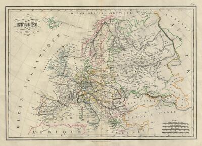
$15.00 Shipping Location: Brooklyn, United States 1835 Malte-Brun Map of Europe WE SELL ONLY ORIGINAL ANTIQUE MAPS- NOT REPRODUCTIONS Title: Europe. Description: This is a fine example of Conrad Malte-Brun's ... more1835 map of europe. The map covers the entire continent from the Atlantic Ocean to the Ural Mountains and from the Arctic Ocean to northern Africa and Turkey. It includes Spain. Portugal, France, Italy, european Russia, Sweden, Denmark, Norway, Germany, Ireland, Great Britain, Turkey in europe and Greece. Issued following the defeat of Napoleonic France and the Congress of Vienna, europe is shown under a new peaceful balance of power, centered around the five most important powers(also referred to as the five'Great Powers' the United Kingdom, France, Russia, Prussia and the Austrian empire. Alas, the'peace' was but an illusion as the treaties ending the Napoleonic era were inherently flawed. Old rivalries festered and nationalism, liberalism, revolution(industrial and otherwise) was once again on the rise throughout europe. Various cities, countries, towns, islands, rivers, lakes and various other topographical details are marked, with relief shown by hachures. Boundaries are color coded according to countries and regions. This map was issued as plate no. 29 in Conrad Malte-Brun's 1837 Atlas Complet du Precis de la Geographie Universelle. Size: Printed area measures 13 inches high by 18 inches wide. Condition: Very good. Original centerfold. Blank on verso. Shipping: Due to recent increases in United States Postal Service rates we have been forced to increase our shipping rates. Shipping rates are not negotiable. Items are shipped within three business days of receiving payment. We are happy to consolidate shipping where possible. The following shipping options are available: 1. USPS Domestic Express Mail(35 USD) USA Only. 2. FedEx Ground or Home Delivery(15 USD) USA Only. 1- 10 days. If your address is a P.O.Box and cannot ship FedEx we will ship USPS Priority and. While we ship promptly, recent postal personnel cutbacks mean that de
Buy It Now
Free Shipping Location: Saint-Cyprien, France This is not a recent copy or modern reproduction, but a print from the 1890s.
Buy It Now
Free Shipping Location: Training Battalian S.O, India Material : Aluminum, Brass & Wood. Finish : Brass Polish. With Bell Sound Both Side. All Work is Hand Made. Look Photos For Actual Image Of Product. Best ... morefor gift.
Buy It Now
Free Shipping Location: Training Battalian S.O, India Its intricate details and brass construction make it a valuable addition to any collection. With Bell Sound Both Sides. Finish : Brass Antique. Material ... more: Brass & Wood. This is a Reproduction Item, Not Sold As Antique.
Buy It Now
Free Shipping Location: Training Battalian S.O, India Working Porthole Open and Close. Material : Aluminum & Mirror. Finish : Brass Polished Finish.
Buy It Now
Free Shipping Location: Japan In the event of any delays rest assured that we will investigate and take responsibility. It may take longer than the estimated arrival date due to carrier ... moreand traffic conditions in each region. This ensures the provenance and quality of each product.
Buy It Now
$4.00 Shipping Location: Harborton, United States ANTIQUE 1930'S ANIMATED WYOMING STATE PICTURE MAP. This neat Wyoming picture map features sketches of people, mountains, animals, vegetation, and more. ... moreIt is in very good condition. There is text on the reverse side.
Buy It Now
Free Shipping Location: Uncha Gaon B.O, India FULLY HANDCRAFTED ENGRAVED COMPASS. THIS COMPASS IS MAINLY USE FOR DIRECTION. MATERIAL - BRASS, GLASS & leather. FINISH - ANTIQUE BRASS FINISH (as shown ... morein pic). ONE OF THE BEST GIFT FOR YOUR LOVED ONES.
Buy It Now
$4.99 Shipping Location: Fairview, United States It is fromThe Geographical Annual published in Philadelphia by Carey, Lea & Blanchard, 1834, a facsimile copy of the title page is included for authenticity. ... moreIf you are looking for a beautiful map with strong color, they don't get much better than this.
Buy It Now
Free Shipping Location: Chesterton, United States 1st map of Northbrook, found so far. We own a collection of drawing from before the Great Chicago Fire of 1871 that were used as courts’ exhibits in the ... moreabove noted cases. The size is appr. 8.5" x 14".
Buy It Now
$20.05 Shipping Location: Woodside, United States A Beautiful & Very Lavish Photo Frame.A Victorian Reproduction, in MINT condition!It measures:5" from top to bottom, & 5" across.Photo size: 2" by 2 1/2".Oval ... moreCenter.MINT!
Buy It Now
$4.99 Shipping Location: Louisville, United States This is an original hand-colored lithograph map of Switzerland, printed by Cowperthwaite in 1950. The map is spotted, but is otherwise in good condition.
Buy It Now
Free Shipping Location: China ~ Chinese Vintage/Antique Bronze/Brass Incense Burner or Censer with Candle Holder ~ Incredible old Chinese brass/bronze censer or incense burner with ... morea removable candle holder top. It features lovely cut-out detailing and dragon/foo dog feet and details. Felt pads have been put on the feet to protect your surfaces. Very good condition with some patina. Age, and signs of use. This piece is quite large! The censer measures 8.5" tall x 12" wide. The candle holder measures 9.75" tall. Overall the piece stands 15" tall. Not marked. As always. Thank you so much for looking! Enjoy the day!
Buy It Now
Free Shipping Location: Pahrump, United States
Buy It Now
$11.75 Shipping Location: Franklin, United States Laceleaf or Anthurium. Author:Louis Van Houtte & Charles Lemaire. Print Style: Color Lithograph. General Condition: The general condition of the plates ... moreof this work is in very good to excellent condition overall.
Buy It Now
$15.50 Shipping Location: Franklin, United States Woodpecker, Pigeon Hawk, Nuthatch, & Warblers. He spent a decade traversing the Eastern United States studying the birds and discovered 26 previously ... moreunknown species. This edition was published in 1871 in Philadelphia by Porter & Coates.
Buy It Now
$19.50 Shipping Location: Franklin, United States The work was published in London by Richard and John E. Taylor for the author between 1840 and 1869. Over 300 new species of Australian birds were identified ... morethrough the production of this work, and it remains one of the most comprehensive works on Australian ornithology.

Buy It Now
$4.00 Shipping Location: Winter Springs, United States Click Here. Double your traffic. Get Vendio Gallery- Now FREE! Vintage antique 1874 handcolored map. The conditon of the map is amazing. The map is titled. ... moreIn superb fancy antique lettering, Atlas of Illinois, Counties of LaSalle, Grundy and Livingston, beautiful county map. The map is very detailed, with the period cities, towns, named railroads and much more. The map has a nice outside ornate border as well. The map is in excellent fine conditon. Very finely produced map, printed on thick fine paper. This is an antique map and not a reprint or reproduction. The map is from the very rare 1874 Warner and Beers Atlas of McLean County Illinois. The map is a fascinating and historic period look at this area at this time. The photo wont show the full beauty of the map. The map is in nice shape and would frame and display quite beautifully. The size of the map is 16" by 18" Winning bidder pays $4.00 shipping domestic, more foreign. Payment I accept the following forms of payment: PayPal Click to View Image Album Shipping& Handling $4.00 USPS First-Class Mail® FREE scheduling. Supersized images and templates. Get Vendio Sales Manager. FREE scheduling. Supersized images and templates. Get Vendio Sales Manager. Win more auctions at the last minute FREE. Learn how.
Buy It Now
Free Shipping Location: Training Battalian S.O, India We use manually Dying and Antique process to burn and other Techniques. (Used Manually Dyeing Antique Process Colour May Be Differ A Little Bit Due To ... moreManually). Model: Boston Mark V.
Buy It Now
$18.51 Shipping Location: Kyogle, Australia
Buy It Now
Free Shipping Location: Training Battalian S.O, India

Buy It Now
$10.00 Shipping Location: Cyprus . Origin one of the first editions of: Voyage das L’Hemisphere Austral. Et autour du Monde, fait sur les Vaisseaux de Roi. L, Aventure& la Resolution… ... moreEcrit par Jacques Cook. Commedant de la Resolution… Cook's Third Voyage(1776-1779) In three voyages Cook sailed thousands of miles across largely uncharted areas of the globe. He mapped lands from New Zealand to Hawaii in the Pacific Ocean in greater detail and on a scale not previously achieved. As he progressed on his voyages of discovery he surveyed and named features. And recorded islands and coastlines on European maps for the first time. He displayed a combination of seamanship, superior surveying and cartographic skills, physical courage and an ability to lead men in adverse conditions. ORIGINAL ANTIQUE COPPER PLATE ENGRAVING. Engraving is Absolutely Guaranteed authentic original map. A Certificate of Authenticity will be on request forwarded for each individual map or print. Size: Sheet app. 40 x 26 cm. 15.5 x 10 inches. Condition: Very good. Smoke free print. Fold as published. All maps and prints are genuine. Authentic, published at the date stated in this listing! For better quality pictures please go to our web site: WWW.MAPANDMAPS.COM I offer a no questions returns policy. All maps and prints are genuine. Authentic, published at the date stated above. Shipping: Worldwide shipping by signed registered mail or Global Express courier . Standard Int'l Shipping means registered airmail of Europe. If you want to receive the item quickly. Ask for Expedited Int'l Shipping or a 3 days Shipping by FedEx. between $ 25.95 and $ 38.50) Shipping fee is per combined shipment. Including handling and insurance. Free shipping worldwide if three items or more purchased. . . . 1?RcmdId ViewItemDescV4,RlogId p4%60bo7%60jtb9%3Feog4d72f%2B%3E%3B1%3F-141c2ef1707-0xfd-
Buy It Now
$3.50 Shipping Location: Dover, United States Fivemile Creek Quadrangle Texas- 7.5 Minute Series. Year Published: 1972.
Buy It Now
Free Shipping Location: Morocco This is an incredibly rare Neolithic flint carved arrowhead from Stone Age Britain, dating back to 3000 B.C. It is an original piece, not a reproduction, ... moreand is in excellent condition considering its age.
Buy It Now
$4.19 Shipping Location: Portland, United States Make the most personalized art calendar ever for yourself. Make prints to hang on your wall. Or just simply enjoy the beauty of projecting the slides. ... moreget your own projector for twenty bucks, and transform empty wall space into a beautiful work of art.
Buy It Now
$10.00 Shipping Location: Cyprus Title: Congo Cafrerie. Condition: Nice map in good condition, fold as published. For the complete Map and Print collection see our online site.
Buy It Now
$4.99 Shipping Location: Fairview, United States It is from Houze's. Atlas Universel Historique et Geographique, published in Paris in 1849. A copy of the Atlas title page is included for authenticity. ... moreIt is an antique historical map. Condition: It is in Very Good condition for its age printed on heavy paper, blank on the reverse with original hand color outlining as issued.
Buy It Now
$200.00 Shipping Location: Training Battalian S.O, India We use manual hand held process to give antique finish to the stuff. Finish: Old Copper Antique (As shown in picture). Manually Dyeing Process used in ... moreOuter Antique Finish, so Color May Differ also Due To Light Effect in Photography.
Buy It Now
Free Shipping Location: Training Battalian S.O, India Material : Solid Steel Iron, brass. Finish : Antique Finish. This is a Reproduction Item, Not Sold As Antique. Good Piece Of Collection. Look Photos For ... moreActual Image Of Product. All Work is Hand Made.
Buy It Now
$28.11 Shipping Location: HASLEMERE, United Kingdom A magnificent highly detailed panoramic bird's eye view of Victorian London, printed and hand-coloured by J. Sulman for The Illustrated London News in ... more1892. The Illustrated London News was the first and the longest running illustrated weekly news magazine.
Buy It Now
$11.75 Shipping Location: Franklin, United States The work was completed under the direct supervision of J. J. Audubon. The lithography and hand-coloring was completed by J. T. Bowen. General Condition: ... moreThe work is in fair to very good condition overall.
Buy It Now
$15.00 Shipping Location: Brooklyn, United States A beautiful black and white lithograph, the entrance to the cave is situated in the foreground, with what appears to be stones and beams marking the way ... morein. Title: Howe's Cabe Cobleskill N.Y. Signature Required.
Buy It Now
$3.75 Shipping Location: United States Often the actual antique map is close in price to a reproduction, so why buy a cheap worthless reproduction when you can buy the actual original heirloom?. ... moreThe handcoloring on the map is period to the map, this is before color printing.
Buy It Now
$30.84 Shipping Location: CARNFORTH, United Kingdom Overall height 45mm including toggle. solid oak sanded and finished to recieve your own finish. scolmore switch.
Buy It Now
$4.99 Shipping Location: Fairview, United States Atlas Portatif de France (Paris, 1833). The map is not mounted nor matted, being sold as a single sheet as seen in the first pic. A nice miniature map ... morewith much detail. Condition: The map is in Very Good condition for its age, blank on the reverse, basically as seen in the pic.

Buy It Now
$4.99 Shipping Location: Fairview, United States Lake Erie Maps& Prints! An Original Antique Map: Not a Reproduction! See Our Ebay Store for More! Free Shipping on Purchases of 5 or More Maps and ... morePrints Description: It is an authentic antique map approximately 114 years old from the 1896 edition of Andrees Allgemeiner Handaltas(Andrees General Atlas) Published(Beilefeld and Liepzig: Verlag von Velhagen& Klassing, 1896) A copy of the title page is included for authenticity. It was printed by Chromolithography utilizing zinc plates eteched in relief. The labeling language is in German. In general, the Andrees maps are exceptional for their detail and vibrant color, which are among the best of the late 19th century maps. The map is being sold unmatted or framed as seen in the first pic, printed on a large heavy sheet, blank on the reverse with a centerfold as issued. Overall a beautiful map in great condition. Size: The map image area from neat line to neat line measures approximately 9 by 14 1/2 inches(23x37cm) on a 11 by 17 1/2" 28x44cm) page with a margin all around for framing. Condition: The map is in Very Good to Excellent condition for its age with vibrant color on a bright sheet. Other than a couple of minor spots in the margin. Hardly worth mentioning, it is very clean with a strong impression and rich color that would frame up well. It is much better than shown in the pic. The pics are of the actual map. Payment Details: We accept most major credit cards through Paypal and Ebay. Please ask if you have any questions about payment. International and New Bidders are welcomed and encouraged. Payment is expected within 7 days. After which Nonpaying Bidders will be reported to Ebay to recoup our listing fees. Save on Shipping: We only charge one shipping fee based on the largest map or print with multiple items shipped along with it for no extra costs. Purchase 5 or more maps or prints and receive Free First Class shipping in USA or First Class International elsewhere in the world. Although registration may be required on shipments of high value t
Buy It Now
$14.50 Shipping Location: Johnson City, United States The World by Jansson 1632 D.A.C Inc. N.Y. Reproduction USA - No. 1693. Under Shellac on Wood. Attached Rope for Hanging.
Buy It Now
$4.00 Shipping Location: United States This is an antique 1872 map and not a reprint or reproduction. The map is in excellent condition. The map is printed on thick fine paper, with no printing ... moreon reverse. This is an antique map and not a reprint or reproduction.
Buy It Now
$3.75 Shipping Location: Winter Springs, United States The map is titled Macedon, I see Macedon PO, Macedon Centre PO and more. This is an antique map and not a reprint or reproduction. The handcoloring on ... morethe map is period to the map, this is before color printing, the map is printed on thick paper, with no printing on reverse, fine outside ornate border as well.
Buy It Now
$15.50 Shipping Location: Franklin, United States He spent a decade traversing the Eastern United States studying the birds and discovered 26 previously unknown species. This edition was published in ... more1871 in Philadelphia by Porter & Coates. (Frank L. Burns, "Alexander Wilson. ).
Buy It Now
$5.95 Shipping Condition: New Location: United States Year: 1585. The Voyages of Sir Francis Drake - Santiago Cape Verde Islands. This great Historic Map print shows Sir Francis Drake's voyage to Santiago, ... moreCape Verde Islands during his West Indian voyage of 1585-1586.
Buy It Now
$6.40 Shipping Location: Wilmington, United States Not a photocopy or more recent reproduction.
Buy It Now
$21.02 Shipping Location: CANTERBURY, United Kingdom This set of five topographical maps of Canterbury is a must-have for any antique map collector. With a date range of 400-1700 and a vintage reproduction ... morestyle, these folding maps were published by the Canterbury Archaeologica Trust. The maps depict the city of Canterbury and its surrounding areas in Kent, making them a perfect addition for those interested in European maps. Each map in this set has been carefully crafted and contains intricate details of the city's landscape and historic sites. Whether you're a cartography enthusiast or simply looking for a unique piece of history, these topographical maps are sure to impress.
Buy It Now
$4.99 Shipping Location: Fairview, United States It was publsihed in Paris, H. Langlois, 1841. Included is a facsimile copy of the title page for authenticity. Condition: The map is in Very Good to Excellent ... morecondition with overall light tonal aging and original hand coloring as issued.
Buy It Now
$4.99 Shipping Location: Fairview, United States There is a map or text on reverse. There is also a similar style map on the reverse. The pics are of the actual map. An Authentic Antique Map: Not a Modern ... moreReproduction!
Buy It Now
$5.45 Shipping Location: Oceanside, United States Early Road Map London To Oxford John Ogilby 1675 Hand Painted 13"x 10". Shipped with USPS First Class Package. Item does have some age related wear .
Buy It Now
$8.20 Shipping Location: Houston, United States
Buy It Now
Free Shipping Location: Manglour Town S.O, India
|