Buy It Now
Free Shipping Location: Netherlands Description: Source unknown, to be determined. These type of charts are scarse as they were actually used at sea for navigation. Artists and Engravers: ... moreMade by an anonymous engraver after 'Jacques-Nicolas Bellin for the Depot de la Marine'. Jacques-Nicolas Bellin (1703-1772) was one of the most important cartographers of the 18th century. With a career spanning some 50 years, Bellin is best understood as geographe de cabinet and transitional mapmaker spanning the gap between 18th and early 19th century cartographic styles. His long career as Hydrographer and Ingénieur Hydrographe at the French Dépôt des cartes et plans de la Marine resulted in hundreds of high quality nautical charts of practically everywhere in the world.
Buy It Now
Free Shipping Condition: New Location: United States One of the more striking examples of the U.S. Coast Survey Map of North Carolina's Cape Fear and Cape Fear River. Extends from Federal Point south to ... morethe top of Cape Fear and then west past Smithville and Fort Caswell to Oak Island (roughly 78.04 Longitude).
Buy It Now
Free Shipping Condition: New Location: United States 1874 map of end of the Mississippi River Delta, Plaquemines Parish, Louisiana. Due to the quick and dramatic changes in the Delta area due to sudden storms ... moreand hurricanes, charting the Mississippi Delta was one of the U.S. Coast Survey's most daunting tasks.
Buy It Now
Free Shipping Condition: New Location: United States Represents the culmination of the Coast Survey's work in this region. The preliminary work for this region was completed in 1857. The triangulation for ... morethis chart was calculated by C. P. Bolles. The topography was completed by C. P. Bolles and J. S Bradford.
Buy It Now
$6.00 Shipping Condition: Unspecified Location: Santa Barbara, United States 1852 Coast Survey Chart Monterey Bay California, Rare Nautical Chart Colored Chart of Monterey Bay, showing Monterey town plan, Point Pinos, Pt. This ... morechart has very nice inland detail and includes a profile view of Pt.
Buy It Now
$4.00 Shipping Location: Columbus, United States US Coast Survey, Southwest Pass of the Mississippi River, 1862, No. 36. 18 1/2" x 14 3/4," nice condition, folding map, complete.
Buy It Now
$6.80 Shipping Condition: Unspecified Location: Santa Barbara, United States Heavy paper, separate issue. Triangulation by A.F. Rodgers and G. Davidson Assistants. Topography by J.S. Lawson and A.F. Rodgers Assists. … Reissued ... moreJune 1883, J.E. Hilgard Superintendent. (Date of first publication 1860).
Buy It Now
$6.00 Shipping Condition: Unspecified Location: Santa Barbara, United States This later edition includes greater inland detail of the U.S. Navy Yare, City of Vallejo, and topographic features. Mare Island Straits California. Report ... moreof the Superintendent of the Coast Survey, Showing the Progress of the Survey During the Year 1857.
Buy It Now
$6.00 Shipping Condition: Unspecified Location: Santa Barbara, United States 1854 Coast Survey Chart Santa Cruz Harbor, Point Ano Nuevo, California Nautical Detailed chart of Santa Cruz Harbor and Vicinity and Point Año Nuevo Anchorage. ... moreA sub-sketch of the relative positions of the harbors is included.
Buy It Now
$10.04 Shipping Condition: Unspecified Location: LONDON, United Kingdom [Part of Northumberland]. Caption below picture:'[Part of Northumberland]'. Collins was an officer of the Royal Navy and prominent hydrographer, who was ... morecommissioned by King Charles II in 1676 and appointed by Samuel Pepys (then Secretary to the Admiralty), to chart the coasts of Great Britain.
Buy It Now
$6.00 Shipping Condition: Unspecified Location: Santa Barbara, United States 1864 Coast Survey Chart Ohio River Mound City Cairo, Mississippi River Nautical A striking U.S. Coast Survey chart showing a section of the Ohio River ... morefrom the confluend of the Mississippi River at Cairo to Mound City.
Buy It Now
$6.80 Shipping Condition: Unspecified Location: Santa Barbara, United States This is appears to be a restrike issue from the original plate of the 1864 chart by the Coast Survey. Bodega Bay, California. Triangulation by G.A. Fairfield ... moreand G. Davidson Assistants. Rodgers, A. F. ; Davidson, George ; Fairlield, G.A. ; Sands, B.F.
Buy It Now
$14.75 Shipping Location: Quincy, United States Map number 4103. Measures 25" x 27-1/2" single sheet. Originally published in 1941 by the US Coast and Geodetic Survey, this is the 1945 updated edition. ... moreFading and foxing. Clipped corner, no tears or issues. Please see pictures. mbox3
Buy It Now
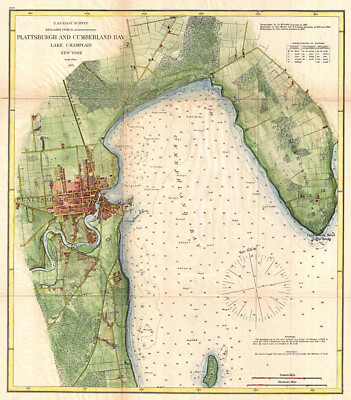
$3.95 Shipping Condition: New Location: Clarkston, United States This Auction is for an Unframed Modern REPRINT of an Antique Map This map is printed on specially coated. Matte finish, paper for sharper print quality ... moreand colors that are vivid. Original Map Details Plattsburgh and Cumberland Bay Lake Champlain New York. Approximate Image Size 16.5 X 19 inches Details"A very attractive example of the 1872 U.S. Coast Survey nautical chart or map of Plattsburgh and Cumberland Bay. Lake Champlain, New York. This map covers the urban center of Plattsburgh as well as the surrounding areas as far south as Crab Island and as far north as far east as Cumberland Head. The map includes the course of the Saranac River as it passes south of the city and route of the Whitehall and Plattsburgh Railroad. Offers exceptional inland detail with important building, streets, and property lines shown. In Lake Champlain there are countless depth soundings as well as notes on reefs and shoals. This map was surveyed during the tenure of A. D. Bache as Superintendent of the Survey but was produced under the supervision his successor, Benjamin Peirce. from Wikipedia WE HAVE MANY HISTORIC REPRINT MAPS AND OTHER ITEMS ON MANY DIFFERENT SUBJECTS Please check out store for additonal products Powered by The free listing tool. List your items fast and easy and manage your active items.
Buy It Now
Free Shipping Location: Netherlands Description: Published by the Depot de la Marine, 1853. Artists and Engravers: Made by 'C.E. Collin' after 'Depot de la Marine'. Depot des Cartes et Plans ... morede la Marine (1720 - present), often called the Depot de Marine, was a French hydrographic mapping organization founded in 1720. Much like the U.S. Coast Survey, the British Admiralty, and the Spanish Deposito Hydrografico, the Depot was initiated as a storehouse and distribution center of existing nautical and marine charts. Eventually the Depot initiated its on mapping activities in an attempt to improve and expand upon existing material. Some of the well known hydrograhers / cartographers in the development of Depot were Jacques Nicholas Bellin and Riobert Bonne.
Buy It Now
Free Shipping Location: Netherlands Description: Published by the Depot de la Marine, based on the survey of Captain Gauttier in 1820. These type of charts are scarse as they were actually ... moreused at sea for navigation. Artists and Engravers: Made by 'E. Collin' after 'Depot de la Marine'. Depot des Cartes et Plans de la Marine (1720 - present), often called the Depot de Marine, was a French hydrographic mapping organization founded in 1720. Much like the U.S. Coast Survey, the British Admiralty, and the Spanish Deposito Hydrografico, the Depot was initiated as a storehouse and distribution center of existing nautical and marine charts. Eventually the Depot initiated its on mapping activities in an attempt to improve and expand upon existing material.
Buy It Now
$11.92 Shipping Location: SHREWSBURY, United Kingdom A highly detailed and interesting large format steel engraved sea chart of the Riviera di Ponente in the Golfo di Genova. Original Antique Sea Chart Old ... moreNautical Map. 36" x 24.5" (920mm x 620mm) map area only, with margins beyond.
Buy It Now
Free Shipping Condition: New Location: United States We take quality seriously. Your item is custom printed on acid-free premium matte photo paper with archival inks. Giclee Art Prints. Assembling with no ... moretools in a less than a minute, these hand-made hangers are made of the highest quality teak hardwood and super strong neodymium magnets.
Buy It Now
$6.00 Shipping Condition: Unspecified Location: Santa Barbara, United States 1862 USCS Coast Survey Chart Potomac River, Sheet 4 Indian Head to Georgetown A striking nautical chart showing the section of the Potomac River from ... moreIndian Head to Georgetown. This is sheet 4 of a 4-sheet set of the Potomac River.
Buy It Now
Free Shipping Condition: Used Location: Eugene, United States This is an ORIGINAL WORLD WAR II JUNE 1945 (RESTRICTED!). This map was created from a 1938 Japanese survey. This is the June 1945 edition created as the ... moreUnited States was on the verge of invading Japan.
Buy It Now
$14.75 Shipping Location: Quincy, United States Vintage US navy chart from British surveys last corrected in 1943. Measures 28-1/2" x 22" with two fold lines. Published by The Hydrographic Office in ... moreWashington DC. Published 1947. Very good condition with no tears or fading Please see pictures. mf1
Buy It Now
$4.95 Shipping Location: Dover, United States From a Spanish Survey in 1874. (Asia - Philippines Islands- Mindanao islands). Detailed early 20th century nautical map. Tinted lithography. Small format, ... morecharming little reduced size map.
Buy It Now
$14.75 Shipping Location: Quincy, United States Map number 1247. Measures 34-1/2" x 47-1/2" with one fold line. Published in 1944 by the US Coast and Geodetic Survey. Fading and creases to margins. ... moreCreases to fold area at both sides. Very good overall. Please see pictures., no tears or issues Please see pictures. mbox3
Buy It Now
$15.00 Shipping Location: Brooklyn, United States The map covers from eastern Lan Tau Island to Kowloon and from Tsing Yi (ÈùÃË°£, Chung Hue) to Victoria (Hong Kong Central, Sai Wan, Sai Ying Pun, ... moreand Sheung Wan. It exhibits copious c. 1930 manuscript updates in the vicinity of Kowloon, including a heavily annotated pastedown. ).
Buy It Now
$6.00 Shipping Condition: Unspecified Location: Santa Barbara, United States 1862 USCS Coast Survey Chart Potomac River, Sheet 3 Cedar Point to Indian Head A striking nautical chart showing the section of the Potomac River from ... moreLower Cedar Point to Indian Head. This is sheet 3 of a 4-sheet set of the Potomac River.
Buy It Now
$6.00 Shipping Condition: Unspecified Location: Santa Barbara, United States 1862 USCS Coast Survey Chart Potomac River, Sheet 1 Entrance to Piney Point A striking nautical chart showing the section of the Potomac River from the ... moreentrance to Piney Point. This is sheet 1 of a 4-sheet set of the Potomac River.
Buy It Now
$6.00 Shipping Condition: Unspecified Location: Santa Barbara, United States 1862 USCS Coast Survey Chart Potomac River, Sheet 2 Piney Point to Cedar Point A striking nautical chart showing the section of the Potomac River from ... morePiney Point to Lower Cedar Point. This is sheet 2 of a 4-sheet set of the Potomac River.
Buy It Now
$33.88 Shipping Condition: Unspecified Location: LONDON, United Kingdom Collins was an officer of the Royal Navy and prominent hydrographer, who was commissioned by King Charles II in 1676 and appointed by Samuel Pepys (then ... moreSecretary to the Admiralty), to chart the coasts of Great Britain.
Buy It Now
$23.21 Shipping Location: SHREWSBURY, United Kingdom Published by Jacques Bellin, Paris 1757 in;. Captain Greenville Collins first published his Coasting Pilot in 1693. Original Antique Sea Chart Old Nautical ... moreMap. by Greenville Collins. Free of repairs or restoration.
Buy It Now
Free Shipping Location: Netherlands Description: Published by the Depot de la Marine, 1815. These type of charts are scarse as they were actually used at sea for navigation. Artists and ... moreEngravers: Made by 'E. Collin' after 'Depot de la Marine'. Depot des Cartes et Plans de la Marine (1720 - present), often called the Depot de Marine, was a French hydrographic mapping organization founded in 1720. Much like the U.S. Coast Survey, the British Admiralty, and the Spanish Deposito Hydrografico, the Depot was initiated as a storehouse and distribution center of existing nautical and marine charts. Eventually the Depot initiated its on mapping activities in an attempt to improve and expand upon existing material.
Buy It Now
$23.21 Shipping Location: SHREWSBURY, United Kingdom From Greenville Collins' "Great Britain's Coasting Pilot" published by Mount and Page in 1756. Published London 1756 by Mount & Page. by Greenvile Collins ... more(also Greenville). Captain Greenville Collins first published his Coasting Pilot in 1693.
Buy It Now
$44.99 Shipping Location: Ivanhoe, Australia Date: - 1626 (1676). This map is both beautiful and important. In the high Arctic, near Iceland and Greenland, the supposed islands of Frisland and Brasil ... moreare noted. Frisland is little more than a double mapping of Iceland.
$3.95 Shipping Condition: Unspecified Location: Clarkston, United States 1770 U.S. Survey Coastal Map. Covers the coast of Long Island from Eaton's Neck to Yellow Hook, western Long Island Sound, parts of New York Harbor and ... moreManhattan Island, and the Paulus Hook area of New Jersey.
$3.95 Shipping Condition: New Location: Clarkston, United States Engraved nautical chart. Relief shown by hachures; depths by soundings. Includes descriptive notes. This is a reproduction of the original map. Map Size: ... more9"x16".
Buy It Now
$33.88 Shipping Condition: Unspecified Location: LONDON, United Kingdom Morston and Cley-next-the-Sea�are also marked. Sandbanks and ocean depths are indicated. The map is orientated towards the south. [Blakeney & environs] ... more- To Sr. Clodlsley Shouel Kt, Rear Admll. Of the Blew this is most humbly dedicated and presented by Capt. G Collins.
Buy It Now
$33.88 Shipping Condition: Unspecified Location: LONDON, United Kingdom Collins was an officer of the Royal Navy and prominent hydrographer, who was commissioned by King Charles II in 1676 and appointed by Samuel Pepys (then ... moreSecretary to the Admiralty), to chart the coasts of Great Britain.
Buy It Now
$23.21 Shipping Location: SHREWSBURY, United Kingdom THE ISLANDS OF ORKNEY. An original 18th century untitled copper engraved antique sea chart of the Orkney Islands, Scotland enhanced with attractive later ... morehand colouring. From Greenville Collins' "Great Britain's Coasting Pilot" published by Mount and Page in 1756.
Buy It Now
$18.42 Shipping Location: GULLANE, United Kingdom This chart shows in great details of UIG BAY. Admiralty Chart No.3669. ADMIRALTY SEA CHART of. Originally published by the British Admiralty in 1907. ... moreSold by J. D. Potter. Agent for the sale of Admiralty Charts.
Buy It Now
$23.21 Shipping Location: SHREWSBURY, United Kingdom Published by Jacques Bellin, Paris 1757 in;. Captain Greenville Collins first published his Coasting Pilot in 1693. An original 18th century copper engraved ... moreantique sea chart of the Milford Haven area of Wales from a French edition of Greenville Collins' "Great Britain's Coasting Pilot".
Buy It Now
$6.95 Shipping Location: Dover, United States Ambil Passage Lubang and Ambil Islands. From a Spanish Survey in 1834. Detailed early 20th century nautical map, lithography.Small format, charming little ... morereduced size. (Asia - Philippines Islands).
Buy It Now
$21.33 Shipping Condition: Unspecified Location: LONDON, United Kingdom PROVENANCE: London. Published at the Admiralty under the Superintendence of Rear Admiral W.J.L. Wharton F.R.S., Hydrographer. Large British nautical sea ... morechart. DATE PRINTED: Surveyed to 1890. Published 1895.
Buy It Now
$23.21 Shipping Location: SHREWSBURY, United Kingdom Covers Kingston upon Hull, Grimsby, Paull, Ottringham, Patrington, Barton upon Humber etc. Sunk island is actually an island proper before silting and ... moreland reclamation joined it to the mainland. An original 18th century copper engraved antique sea chart of the Humber Estuary, England.
Buy It Now
$35.13 Shipping Location: HASTINGS, United Kingdom The map was the work of Captain Greenvile Collins. The event was enough to stimulate action: it was clear that the Dutch had better sea charts of the ... moreBritish coast than the British themselves, and Captain Greenvile Collins was given the task of surveying the entire coastline of Great Britain.
Buy It Now
$18.42 Shipping Location: GULLANE, United Kingdom VENGURLA to CAPE COMORIN. This chart shows great details of VENGURLA to CAPE COMORIN. ADMIRALTY SEA CHART. Admiralty Chart No. 827. Originally published ... moreby the British Admiralty in 1877. Sold by J. D. Potter.
Buy It Now
Free Shipping Condition: New Location: United States This is a museum-grade reproduction of a rare 1857 nautical chart of the Massachusetts coast from Plymouth, MA to Saughkonnet River, RI. Includes Barnstable ... morecounty, Cape Cod, Nantucket, and Martha's Vineyard.
Buy It Now
$23.21 Shipping Location: SHREWSBURY, United Kingdom An original 18th century copper engraved antique sea chart of Holyhead, Anglesey, Wales enhanced with attractive later hand colouring. North is orientated ... moreto the left. From Greenville Collins' "Great Britain's Coasting Pilot" published by Mount and Page in 1756.
Buy It Now
$4.95 Shipping Location: Dover, United States Detailed early 20th century nautical map, tinted lithography.Small format, charming little reduced size. (Asia - Philippines Islands- Mindanao- Southeast ... morecoast). Original fold-lines as issued.
Buy It Now
Free Shipping Condition: New Location: United States We take quality seriously. Your item is custom printed on acid-free premium matte photo paper with archival inks. Giclee Art Prints. Assembling with no ... moretools in a less than a minute, these hand-made hangers are made of the highest quality teak hardwood and super strong neodymium magnets.
Buy It Now
$3.00 Shipping Condition: Unspecified Location: Springfield, United States This is an eBook in PDF format copied to blank CD.
Buy It Now
$17.99 Shipping Location: GULLANE, United Kingdom Admiralty Chart No.3046. ADMIRALTY SEA CHART. Originally published by the British Admiralty in 1961. HASTINGS HARBOUR and APPROACHES. This chart shows ... moregreat details of the APPROACHES to HASTINGS HARBOUR.
Buy It Now
$4.95 Shipping Location: Dover, United States North Coast of Mindanao- Port Misamis From a Spanish Survey in 1896. Detailed early 20th century nautical map, tinted lithography.Small format, charming ... morelittle reduced size. (Asia - Philippines Islands).
Buy It Now
$14.00 Shipping Location: Beograd 6, Serbia Nautical Chart of Cooktown to Booby Islands and Port Moresby in Australia. In 1967 he published The Admiralty Chart, a history of British Naval Hydrography ... morein the Nineteenth Century. Publisher: Admiralty.
Buy It Now
$18.42 Shipping Location: GULLANE, United Kingdom ADMIRALTY SEA CHART. Admiralty Chart No. 1760. Originally published by the British Admiralty in 1891. This 1912 edition. including the West Coast of TAI-WAN ... morefrom. This chart shows great details of the COASTS OF CHINA and TAI-WAN.
Buy It Now
$23.21 Shipping Location: SHREWSBURY, United Kingdom From Greenville Collins' "Great Britain's Coasting Pilot" published by Mount and Page in 1756. Published London 1756 by Mount & Page. by Greenvile Collins ... more(also Greenville). Captain Greenville Collins first published his Coasting Pilot in 1693.
Buy It Now
$18.42 Shipping Location: GULLANE, United Kingdom AMBONG BAY to SAMPANMANGIO POINT. Admiralty Chart No. 2112. ADMIRALTY SEA CHART of. Originally published by the British Admiralty in 1913. Sold by J. ... moreD. Potter. Agent for the sale of Admiralty Charts.
Buy It Now
$33.88 Shipping Condition: Unspecified Location: LONDON, United Kingdom This decorative chart shows the Scilly Isles and the approaches to Land's End, The Lizard and Cape Cornwall. Penzance and Market Jew (Marazion) are marked. ... moreThe island are shown on the map as being to the north of the 50th parallel; they are in fact to the south.
Buy It Now
$33.88 Shipping Condition: Unspecified Location: LONDON, United Kingdom Collins was an officer of the Royal Navy and prominent hydrographer, who was commissioned by King Charles II in 1676 and appointed by Samuel Pepys (then ... moreSecretary to the Admiralty), to chart the coasts of Great Britain.
Buy It Now
$23.21 Shipping Location: SHREWSBURY, United Kingdom An inset chart covers Salcombe. Published London 1756 by Mount & Page. An original 18th century copper engraved antique sea chart of Plymouth Sound and ... morethe surrounding Devon and Cornwall coasts. by Greenvile Collins (also Greenville).
Buy It Now
Free Shipping Location: Netherlands Description: Published by the Depot de la Marine, 1815. These type of charts are scarse as they were actually used at sea for navigation. Artists and ... moreEngravers: Made by 'E. Collin' after 'Depot de la Marine'. Depot des Cartes et Plans de la Marine (1720 - present), often called the Depot de Marine, was a French hydrographic mapping organization founded in 1720. Much like the U.S. Coast Survey, the British Admiralty, and the Spanish Deposito Hydrografico, the Depot was initiated as a storehouse and distribution center of existing nautical and marine charts. Eventually the Depot initiated its on mapping activities in an attempt to improve and expand upon existing material.
Buy It Now
Free Shipping Location: Netherlands Description: Published by the Depot des Cartes et Plans de la Marine, 1863. The text by A. Blanchard. Artists and Engravers: Made by 'E. Blondeau' after ... more'Depot de la Marine'. Depot des Cartes et Plans de la Marine (1720 - present), often called the Depot de Marine, was a French hydrographic mapping organization founded in 1720. Much like the U.S. Coast Survey, the British Admiralty, and the Spanish Deposito Hydrografico, the Depot was initiated as a storehouse and distribution center of existing nautical and marine charts. Eventually the Depot initiated its on mapping activities in an attempt to improve and expand upon existing material.
|