|
|
Order by: Available to: This site contains affiliate links for which I may be compensated
|

Buy It Now
$10.75 Shipping Location: Carmel, United States VINTAGE historical EAST BOSTON MASS 1879 OLD ANTIQUE STYLE MAP art print THIS IS A HIGHLY DETAILED MAP OF BOSTON MASS CIRCA 1879 THIS PRINT MEASURES 18"X ... more24" 46cm x 61cm) THIS MAP HAS GREAT DETAIL SEE PHOTOS BELOW Fine Art Giclee(not a laser print) THIS IS A MODERN REPRINT PRINTED ON FINE ART PAPER not a second or third generation print This will be printed in its full aspect ratio on high quality paper. using ULTRACHROME K3 INKS which are rated up to 125+ years I do not use cheap inks that will fade in a few months very suitable for framing some images may have a thin white border THEARTTIST will not show up on your print PERFECT FOR YOUR HOME. OFFICE, GAME ROOM, MAN CAVE or GARAGE Thank you for looking. PLEASE FEEL FREE TO ASK QUESTIONS. THANKS. You may be interested in on eBay. THANKS FOR LOOKING Payment Instructions I accept PayPal for payment. I prefer PayPal. I require that payment be made within 3 days of the end of auction. Please Email me if you have any questions before you bid. Happy bidding! See PHOTO above to check EXACTLY what youre bidding on Feedback: I take pride in my feedback and strive for 5 Star Service. If you have a problem. Please email me before leaving bad feedback so that we can work something out. Shipping Instructions US Buyers: I use USPS Mail for most shipping needs- Purchases over $250 Will be sent with Signature Conformation International Buyers: International buyers If you need you can contact me prior to bidding to obtain a shipping quote. International buyers can choose how fast they wish delivery by USPS meaning Global Priority. Air Letter Post or Economy Letter Post. All of my shipping charges vary depending on the weight of the item. I will gladly combne Shipping with any of my other auction. drop me an email before bidding and I will try to respond within 24 hours. Important Notice to International Buyers Import duties. Taxes, and charges are not included in the item price or shipping cost. These charges are assessed and collected by your nation's government a
Buy It Now
$10.75 Shipping Location: Carmel, United States THIS IS A LARGE AND HIGHLY DETAILED MAP OF PARIS FRANCE CIRCA 1736. THIS IS A MODERN REPRINT PRINTED ON FINE MATTE PAPER. THIS MAP HAS GREAT DETAIL SEE ... morePHOTOS BELOW. This will be printed in its full aspect ratio on high quality paper.

Buy It Now
$10.75 Shipping Location: Carmel, United States HUGE VINTAGE historical EAST BOSTON MASS 1879 OLD ANTIQUE STYLE MAP art print THIS IS A HUGE AND HIGHLY DETAILED MAP OF BOSTON MASS CIRCA 1879 THIS PRINT ... moreMEASURES 35"X 43" 89cm x 109cm) THIS MAP HAS GREAT DETAIL SEE PHOTOS BELOW Fine Art Giclee(not a laser print) THIS IS A MODERN REPRINT PRINTED ON FINE ART PAPER not a second or third generation print This will be printed in its full aspect ratio on high quality paper. using ULTRACHROME K3 INKS which are rated up to 125+ years I do not use cheap inks that will fade in a few months very suitable for framing some images may have a thin white border THEARTTIST will not show up on your print PERFECT FOR YOUR HOME. OFFICE, GAME ROOM, MAN CAVE or GARAGE Thank you for looking. PLEASE FEEL FREE TO ASK QUESTIONS. THANKS. You may be interested in on eBay. THANKS FOR LOOKING Payment Instructions I accept PayPal for payment. I prefer PayPal. I require that payment be made within 3 days of the end of auction. Please Email me if you have any questions before you bid. Happy bidding! See PHOTO above to check EXACTLY what youre bidding on Feedback: I take pride in my feedback and strive for 5 Star Service. If you have a problem. Please email me before leaving bad feedback so that we can work something out. Shipping Instructions US Buyers: I use USPS Mail for most shipping needs- Purchases over $250 Will be sent with Signature Conformation International Buyers: International buyers If you need you can contact me prior to bidding to obtain a shipping quote. International buyers can choose how fast they wish delivery by USPS meaning Global Priority. Air Letter Post or Economy Letter Post. All of my shipping charges vary depending on the weight of the item. I will gladly combne Shipping with any of my other auction. drop me an email before bidding and I will try to respond within 24 hours. Important Notice to International Buyers Import duties. Taxes, and charges are not included in the item price or shipping cost. These charges are assessed and collected by your nation'
Buy It Now
$10.75 Shipping Location: Carmel, United States THIS IS A HUGE AND HIGHLY DETAILED MAP OF PARIS FRANCE CIRCA 1892. THIS IS A MODERN REPRINT PRINTED ON FINE MATTE PAPER. THIS MAP HAS GREAT DETAIL SEE ... morePHOTOS BELOW. THEARTTIST will not show up on your print.
Buy It Now
$10.75 Shipping Location: Carmel, United States THIS IS A LARGE AND HIGHLY DETAILED MAP OF PARIS FRANCE CIRCA 1705. PLAN DE PARIS. THIS IS A MODERN REPRINT PRINTED ON FINE MATTE PAPER. THIS MAP HAS ... moreGREAT DETAIL SEE PHOTOS BELOW. THEARTTIST will not show up on your print.
Buy It Now
Free Shipping Location: Lincoln, United States All are printed “Hoffmann-La Roche Inc. Nutley 10, N.J.” in the lower margin. Overall condition is very good.
Buy It Now
$10.75 Shipping Location: Carmel, United States THIS IS A HUGE HIGHLY DETAILED MAP OF PARIS FRANCE CIRCA 1615. THIS IS A MODERN REPRINT PRINTED ON FINE MATTE PAPER. THIS MAP HAS GREAT DETAIL SEE PHOTOS ... moreBELOW. THEARTTIST will not show up on your print.
Buy It Now
$10.75 Shipping Location: Carmel, United States THIS IS A HUGE HIGHLY DETAILED MAP OF PARIS FRANCE CIRCA 1652. PLAN DE PARIS. THIS IS A MODERN REPRINT PRINTED ON FINE MATTE PAPER. THIS MAP HAS GREAT ... moreDETAIL SEE PHOTOS BELOW. THEARTTIST will not show up on your print.

Buy It Now
$10.75 Shipping Location: Carmel, United States GIANT VINTAGE historical EAST BOSTON MASS 1879 OLD ANTIQUE STYLE MAP art print THIS IS A GIANT HIGHLY DETAILED MAP OF BOSTON MASS CIRCA 1879 THIS PRINT ... moreMEASURES 43"X 53" 109cm x 135cm) THIS MAP HAS GREAT DETAIL SEE PHOTOS BELOW Fine Art Giclee(not a laser print) THIS IS A MODERN REPRINT PRINTED ON FINE ART PAPER not a second or third generation print This will be printed in its full aspect ratio on high quality paper. using ULTRACHROME K3 INKS which are rated up to 125+ years I do not use cheap inks that will fade in a few months very suitable for framing some images may have a thin white border THEARTTIST will not show up on your print PERFECT FOR YOUR HOME. OFFICE, GAME ROOM, MAN CAVE or GARAGE Thank you for looking. PLEASE FEEL FREE TO ASK QUESTIONS. THANKS. You may be interested in on eBay. THANKS FOR LOOKING Payment Instructions I accept PayPal for payment. I prefer PayPal. I require that payment be made within 3 days of the end of auction. Please Email me if you have any questions before you bid. Happy bidding! See PHOTO above to check EXACTLY what youre bidding on Feedback: I take pride in my feedback and strive for 5 Star Service. If you have a problem. Please email me before leaving bad feedback so that we can work something out. Shipping Instructions US Buyers: I use USPS Mail for most shipping needs- Purchases over $250 Will be sent with Signature Conformation International Buyers: International buyers If you need you can contact me prior to bidding to obtain a shipping quote. International buyers can choose how fast they wish delivery by USPS meaning Global Priority. Air Letter Post or Economy Letter Post. All of my shipping charges vary depending on the weight of the item. I will gladly combne Shipping with any of my other auction. drop me an email before bidding and I will try to respond within 24 hours. Important Notice to International Buyers Import duties. Taxes, and charges are not included in the item price or shipping cost. These charges are assessed and collected by your nation'
Buy It Now
$10.75 Shipping Location: Carmel, United States THIS IS A LARGE AND HIGHLY DETAILED MAP OF PARIS FRANCE CIRCA 1736. This will be printed in its full aspect ratio on high quality paper. I do not use ... morecheap inks that will fade in a few months.
Buy It Now
$16.00 Shipping Location: Czech Republic
Buy It Now
Free Shipping Location: United States 1705 Vintage Paris Map Old world style Style historic old world Map A city plan of Paris France Street map Fine Art Print WALL Poster\nThis is a Highly ... moredetailed map of Paris France Circa 1705THIS MAP HAS GREAT DETAIL SEE PHOTOS P A P E R \nArchival quality Ultrasmooth fine art matte paper 250gsm.\n\n I N K\nGiclee print with Epson Ultrachrome inks that will last up to 108 years indoors. S I Z E\nYou can choose Your preferred size in listing size menu\n11" x 14" / 28 x 36 cm\n16" x 20" / 40 x 50 cm\n18" x 24" / 50 x 61 cm\n24" x 30"/ 61" x 76"cm\n30" x 40" / 76 x 101 cm\n36" x 48" / 91 x 122 cm\n42" x 50" / 109 x 142 cmThis Fine Art Print has been reproduced from the original source .
Buy It Now
$24.23 Shipping Location: Hanover, United States Enhance the aesthetic appeal of your living space with this Vintage Blaeu Wall Map. The lithographed wall map showcases a gold foil finish, providing ... morea vintage look to your décor. Measuring 31x26, this reproduction map features the Old and New World, and is framed to perfection. The cartographer of this map is Willem Blaeu, offering a touch of historic elegance to your home. Perfect for a variety of settings, this map will surely captivate your guests and add a fascinating visual element to your wall.
Buy It Now
Free Shipping Location: United States 1705 Vintage Paris Map Old world style Style historic old world Map A city plan of Paris France Street map Fine Art Print WALL Poster\nThis is a Highly ... moredetailed map of Paris France Circa 1705THIS MAP HAS GREAT DETAIL SEE PHOTOS P A P E R \nArchival quality Ultrasmooth fine art matte paper 250gsm.\n\n I N K\nGiclee print with Epson Ultrachrome inks that will last up to 108 years indoors. S I Z E\nYou can choose Your preferred size in listing size menu\n11" x 14" / 28 x 36 cm\n16" x 20" / 40 x 50 cm\n18" x 24" / 50 x 61 cm\n24" x 30"/ 61" x 76"cm\n30" x 40" / 76 x 101 cm\n36" x 48" / 91 x 122 cm\n42" x 50" / 109 x 142 cmThis Fine Art Print has been reproduced from the original source .
Buy It Now
$16.00 Shipping Location: Radim u Kolína, Czech Republic
Buy It Now
$4.13 Shipping Location: O Fallon, United States
Buy It Now
$10.75 Shipping Location: Carmel, United States CIRCA 1807. Drawn from actual survey by William Bridges City Surveyor; AD 1807. THIS IS A GIANT HIGHLY DETAILED MAP OF NEW YORK CITY. Plan of the City ... moreof New York.
Buy It Now
$10.75 Shipping Location: Carmel, United States THIS IS A LARGE AND HIGHLY DETAILED MAP OF PARIS FRANCE CIRCA 1550. THIS MAP HAS GREAT DETAIL SEE PHOTOS BELOW. This MAP is a modern reprint and will ... morebe printed in its full aspect ratio on high quality matte paper.
Buy It Now
$10.75 Shipping Location: Carmel, United States THIS IS A LARGE AND HIGHLY DETAILED MAP OF PARIS FRANCE CIRCA 1550. This MAP is a modern reprint and will be printed in its full aspect ratio on high ... morequality matte paper. THIS IS A MODERN REPRINT PRINTED ON FINE MATTE PAPER.
Buy It Now
$10.75 Shipping Location: Carmel, United States THIS IS A LARGE AND HIGHLY DETAILED MAP OF PARIS FRANCE CIRCA 1550. This MAP is a modern reprint and will be printed in its full aspect ratio on high ... morequality matte paper. THIS IS A MODERN REPRINT PRINTED ON FINE MATTE PAPER.
Buy It Now
$10.75 Shipping Location: Carmel, United States THIS IS A LARGE AND HIGHLY DETAILED MAP OF PARIS FRANCE CIRCA 1705. PLAN DE PARIS. THIS IS A MODERN REPRINT PRINTED ON FINE MATTE PAPER. THEARTTIST will ... morenot show up on your print. This will be printed in its full aspect ratio on high quality paper.
Buy It Now
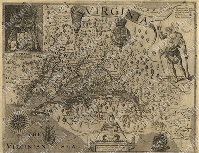
$10.75 Shipping Location: Carmel, United States GIANT VINTAGE 1607 historic JOHN SMITH VIRGINIA MAP OLD ANTIQUE STYLE art print THIS IS A GIANT HIGHLY DETAILED MAP OF VIRGINA AREA CIRCA 1607 THIS PRINT ... moreMEASURES 42"X 54" 107cm x137cm) THIS MAP HAS GREAT DETAIL SEE PHOTOS BELOW THIS IS A MODERN REPRINT PRINTED ON FINE MATTE PAPER This will be printed in its full aspect ratio on high quality paper. using ULTRACHROME K3 INKS which are rated up to 125+ years I do not use cheap inks that will fade in a few months very suitable for framing some images may have a thin white border THEARTTIST will not show up on your print PERFECT FOR YOUR HOME. OFFICE, GAME ROOM, MAN CAVE or GARAGE Thank you for looking. PLEASE FEEL FREE TO ASK QUESTIONS. THANKS. You may be interested in on eBay. THANKS FOR LOOKING Payment Instructions I accept PayPal for payment. I prefer PayPal. I require that payment be made within 3 days of the end of auction. Please Email me if you have any questions before you bid. Happy bidding! See PHOTO above to check EXACTLY what youre bidding on Feedback: I take pride in my feedback and strive for 5 Star Service. If you have a problem. Please email me before leaving bad feedback so that we can work something out. Shipping Instructions US Buyers: I use USPS Mail for most shipping needs- Purchases over $250 Will be sent with Signature Conformation International Buyers: International buyers If you need you can contact me prior to bidding to obtain a shipping quote. International buyers can choose how fast they wish delivery by USPS meaning Global Priority. Air Letter Post or Economy Letter Post. All of my shipping charges vary depending on the weight of the item. I will gladly combne Shipping with any of my other auction. drop me an email before bidding and I will try to respond within 24 hours. Important Notice to International Buyers Import duties. Taxes, and charges are not included in the item price or shipping cost. These charges are assessed and collected by your nation's government and are the buyer's responsibility. Please check with
Buy It Now
Free Shipping Location: United States 1705 Vintage Paris Map Old world style Style historic old world Map A city plan of Paris France Street map Fine Art Print WALL Poster\nThis is a Highly ... moredetailed map of Paris France Circa 1705THIS MAP HAS GREAT DETAIL SEE PHOTOS P A P E R \nArchival quality Ultrasmooth fine art matte paper 250gsm.\n\n I N K\nGiclee print with Epson Ultrachrome inks that will last up to 108 years indoors. S I Z E\nYou can choose Your preferred size in listing size menu\n11" x 14" / 28 x 36 cm\n16" x 20" / 40 x 50 cm\n18" x 24" / 50 x 61 cm\n24" x 30"/ 61" x 76"cm\n30" x 40" / 76 x 101 cm\n36" x 48" / 91 x 122 cm\n42" x 50" / 109 x 142 cmThis Fine Art Print has been reproduced from the original source .
Buy It Now
$4.00 Shipping Location: Chicago, United States The Voyages of Sir Francis Drake 1585 24 X 20 This is a great Classic Map originally published circa 1589. This Map shows Sir Francis Drake's voyage ... moreto the new world during his West Indian voyage of 1585-1586. This map is a vintage stylistic print of the time and features his voyage from Europe to ports in South America. The Caribbean and North America. This poster. Which evokes the vivid images of a simpler time, is a custom reproduction printed on 68lb Heavyweight Enhanced Matte Art Paper. This Historic Art Print is suitable for framing. Mounting or direct display on any wall!
Buy It Now
$10.75 Shipping Location: Carmel, United States THIS IS A GIANT HIGHLY DETAILED MAP OF PARIS FRANCE CIRCA 1609. THIS IS A MODERN REPRINT PRINTED ON FINE MATTE PAPER. THIS MAP HAS GREAT DETAIL SEE PHOTOS ... moreBELOW. THEARTTIST will not show up on your print.
Buy It Now
$6.95 Shipping Location: Carmel, United States THIS IS A LARGE AND HIGHLY DETAILEDASTRONOMICAL AND COSMOGRAPHICAL CHART BY M. VUILLEMIN CIRCA 1852. THIS CHART HAS GREAT DETAIL SEE PHOTO BELOW. PREPARED ... moreBY M. VUILLEMIN AND J. G. BARBIE DU BOCAGE. THIS WILL PRINTED ON FINE ART WATERCOLOR PAPER.
Buy It Now
$10.75 Shipping Location: Carmel, United States THIS IS A GIANT AND HIGHLY DETAILED CIVIL WAR IMAGE OF RICHMOND VIRGINIA CIRCA 1863. This will be printed in its full aspect ratio on high quality paper. ... moreTHIS MAP HAS GREAT DETAIL SEE PHOTO BELOW. THEARTTIST will not show up on your print.
Buy It Now
$10.75 Shipping Location: Carmel, United States THIS IS A GIANT AND HIGHLY DETAILED LUNAR MAP OF THE MOON CIRCA 1880. 1880 EDITION. THIS FASCINATING MAP DEPICTS THE MOON. THIS MAP HAS GREAT DETAIL SEE ... morePHOTO BELOW. THEARTTIST will not show up on your print.
Buy It Now
$10.75 Shipping Location: Carmel, United States THIS IS A LARGE AND HIGHLY DETAILED MAP OF PARIS FRANCE CIRCA 1652. THIS IS A MODERN REPRINT PRINTED ON FINE MATTE PAPER. THEARTTIST will not show up ... moreon your print. This will be printed in its full aspect ratio on high quality paper.
Buy It Now
$10.75 Shipping Location: Carmel, United States THIS IS A GIANT HIGHLY DETAILED MAP OF PARIS FRANCE CIRCA 1652. THIS IS A MODERN REPRINT PRINTED ON FINE MATTE PAPER. THIS MAP HAS GREAT DETAIL SEE PHOTOS ... moreBELOW. THEARTTIST will not show up on your print.
Buy It Now
$9.00 Shipping Location: Wilmington, United States It was published and printed in the USA by Historic Urban Plans of New York.
Buy It Now
Free Shipping Location: United States 1705 Vintage Paris Map Old world style Style historic old world Map A city plan of Paris France Street map Fine Art Print WALL Poster\nThis is a Highly ... moredetailed map of Paris France Circa 1705THIS MAP HAS GREAT DETAIL SEE PHOTOS P A P E R \nArchival quality Ultrasmooth fine art matte paper 250gsm.\n\n I N K\nGiclee print with Epson Ultrachrome inks that will last up to 108 years indoors. S I Z E\nYou can choose Your preferred size in listing size menu\n11" x 14" / 28 x 36 cm\n16" x 20" / 40 x 50 cm\n18" x 24" / 50 x 61 cm\n24" x 30"/ 61" x 76"cm\n30" x 40" / 76 x 101 cm\n36" x 48" / 91 x 122 cm\n42" x 50" / 109 x 142 cmThis Fine Art Print has been reproduced from the original source .
Buy It Now
$16.00 Shipping Location: Radim u Kolína, Czech Republic Also, most tears, folding traces and scratches that have occurred to the originals over the decades have been removed by the digital restoration.
Buy It Now
$7.96 Shipping Location: Carmel, United States A Brockhaus. There are for insets of important lunar craters, the Gutenberg group, the Julius Caesar Group, the Plate Crater, and the Guericke, Parry, ... moreBonpland and Fra. Mauro cluster. Other craters and seas on the moons surface are clearly labeled.
Buy It Now
$10.75 Shipping Location: Carmel, United States THIS IS A LARGE AND HIGHLY DETAILED MAP OF PARIS FRANCE CIRCA 1800. THEARTTIST will not show up on your print. I do not use cheap inks that will fade ... morein a few months.
Buy It Now
$16.00 Shipping Location: Radim u Kolína, Czech Republic Also, most tears, folding traces and scratches that have occurred to the originals over the decades have been removed by the digital restoration.
Buy It Now
$10.75 Shipping Location: Carmel, United States GIANT historic 1705 PLAN DE PARIS CITY WALL MAP OLD ANTIQUE STYLE FINE art print. THIS IS A GIANT HIGHLY DETAILED MAP OF PARIS FRANCE CIRCA 1705. I usually ... morecarry 3 sizes Large, Huge, and Giant. THIS MAP HAS GREAT DETAIL SEE PHOTO BELOW.
Buy It Now
$10.75 Shipping Location: Carmel, United States THIS IS A LARGE AND HIGHLY DETAILED MAP OF PARIS FRANCE CIRCA 1800. THIS MAP HAS GREAT DETAIL SEE PHOTOS BELOW. THEARTTIST will not show up on your print. ... moreI do not use cheap inks that will fade in a few months.
Buy It Now
$6.95 Shipping Location: Arlington, United States THE WORLD IN 1635. Printed in U.S.A. I will work hard to make sure you are satisfied and you can always start a case if you are not happy with my response.
Buy It Now
$10.75 Shipping Location: Carmel, United States THIS IS A GIANT HIGHLY DETAILED MAP OF PARIS FRANCE CIRCA 1705. THIS IS A MODERN REPRINT PRINTED ON FINE MATTE PAPER. THIS MAP HAS GREAT DETAIL SEE PHOTOS ... moreBELOW. THEARTTIST will not show up on your print.
Buy It Now
Free Shipping Location: United States This Is A Giant Highly Detailed Map Of \n The World.\n Circa 1628\n This Map Measures 43" x 62" (110cm x157cm)\n\n This 1628 map by Robert Vaughan shows ... morethe latest discoveries by explorers like Sir Francis Drake Magellan Oliverus Van der Noort and Thomas Cavendish circumnavigating the world. Interestingly\n it shows a southern continent with an interesting description saying that it is as yet unknown but for a few coastlines\n\n THIS MAP HAS GREAT DETAIL SEE PHOTO BELOW \n\n THIS WILL PRINTED ON SMOOTH FINE ART WATERCOLOR PAPER\n\n This map is similar to ones found at Restoration Hardware for \n 1/4 the cost\n\n This Fine Art Print has been reproduced from the original source . \n\n using UltraChrome K3 Inks.
Buy It Now
$16.00 Shipping Location: Radim u Kolína, Czech Republic Also, most tears, folding traces and scratches that have occurred to the originals over the decades have been removed.
Buy It Now
$14.50 Shipping Location: Carmel, United States THIS IS A LARGE AND HIGHLY DETAILEDASTRONOMICAL AND COSMOGRAPHICAL CHART BY M. VUILLEMIN CIRCA 1852. THIS CHART HAS GREAT DETAIL SEE PHOTO BELOW. PREPARED ... moreBY M. VUILLEMIN AND J. G. BARBIE DU BOCAGE. THEARTTIST will not show up on your print.

Buy It Now
$10.75 Shipping Location: Carmel, United States LARGE VINTAGE historic HAWAIIAN SANDWICH ISLANDS 1841 ANTIQUE STYLE MAP print THIS IS A LARGE AND HIGHLY DETAILED MAP OF THE HAWAIAN SANDWICH ISLANDS ... moreCIRCA 1841 THIS PRINT MEASURES 18"X 22" 46cm x56cm) THIS MAP HAS GREAT DETAIL SEE PHOTO BELOW THIS WILL PRINTED ON FINE ART WATERCOLOR PAPER Need this is a different size click the link below to see if I have another size MAPS. This will be printed in its full aspect ratio on high quality paper. using ULTRACHROME K3 INKS which are rated up to 125+ years I do not use cheap inks that will fade in a few months very suitable for framing some images may have a thin white border THEARTTIST will not show up on your print PERFECT FOR YOUR HOME. OFFICE, GAME ROOM, MAN CAVE or GARAGE Thank you for looking. PLEASE FEEL FREE TO ASK QUESTIONS. THANKS. THANKS FOR LOOKING Payment Instructions I accept PayPal for payment. I prefer PayPal. I require that payment be made within 3 days of the end of auction. Please Email me if you have any questions before you bid. Happy bidding! See PHOTO above to check EXACTLY what youre bidding on Feedback: I take pride in my feedback and strive for 5 Star Service. If you have a problem. Please email me before leaving bad feedback so that we can work something out. Shipping Instructions US Buyers: I use USPS Mail for most shipping needs- Purchases over $250 Will be sent with Signature Conformation International Buyers: International buyers If you need you can contact me prior to bidding to obtain a shipping quote. International buyers can choose how fast they wish delivery by USPS meaning Global Priority. Air Letter Post or Economy Letter Post. All of my shipping charges vary depending on the weight of the item. I will gladly combne Shipping with any of my other auction. drop me an email before bidding and I will try to respond within 24 hours. Important Notice to International Buyers Import duties. Taxes, and charges are not included in the item price or shipping cost. These charges are assessed and collected by your nation's governm
Buy It Now
$16.00 Shipping Location: Radim u Kolína, Czech Republic Also, most tears, folding traces and scratches that have occurred to the originals over the decades have been removed by the digital restoration.
Buy It Now
$22.07 Shipping Location: Pelham, United States It is Not a Reprint, Giclee Print nor Ink Jet Print but the Original Authorized Hammond Map Offset Lithograph. Kept Flat, in a Smoke, Dust, and UV Light ... moreFree storage facility for over 40 years that has allowed the Colors to retain their Brilliancy without fading.

Buy It Now
$22.07 Shipping Location: Pelham, United States Guiljelmo Blaeuw Vintage"Italian" Map Reproduced by Hammond Map Incorporated"Courtesy of the New York Public Library" Paper Print. ... moreItem Measures 24 3/4" X 16 3/8" Item is in Near Mint to Mint Condition(C9-C10) We grade our posters according to the Iguide Universal 10-Point Grading Scale: C10 Mint- Investment quality. No perceptible flaws of any kind. C9 Near Mint- Investment quality. Minor flaw on an otherwise unused item. C8 Excellent- Investment quality. A few minor defects. Pin holes. Small tears,etc. C7 Very Good to Excellent- Fine. Several defects. Still a very nicely preserved item. C6 Very Good- The typical used item in average condition. Several defects C5 Good to Very Good- A heavily-worn item. C4 Good- Below average but still suitable for display. C3 Fair- Heavily worn. But yet still complete. C2 Poor to Fair- An extremely worn. Possibly even incomplete item. C1 Poor- The lowest grade. Representing items in the lowest possible condition. Kept Flat. In a Smoke, Dust, and UV Light Free storage facility for over 40 years that has allowed the Image to retain its brilliancy without any fading. It is Not a Reprint. Giclee Print nor Ink Jet Print but the Original Authorized Hammond Map Offset Lithograph Item will be shipped double tubed( the poster is wrapped around one tube in order to avoid kinks and any damage that might happen in handling; the second tube is on the outside for extra protection during shipping) Double tubing would cost extra. But we provide it free for our customers. Customer comments have shown they truly appreciate this free extra care. Following your purchase. Please take a moment to leave us your feedback- Thanks Guiljelmo Blaeuw b etween 1594 and 1596 as a student of the qualified as an instrument and maker. Once he returned to the. He made country maps and world globes, and as he possessed his own printing works, he was able to regularly produce country maps in an atlas format, some of which appeared in the published in 1635. In 1633 he was appointed map-
Buy It Now
$16.00 Shipping Location: Radim u Kolína, Czech Republic This is a digitally re-mastered copy of historical map of Australia by E. Debes (Wagner & Debes, Leipzig), from E. Debes New Table Atlas of the World. ... moreAlso, most tears, folding traces and scratches that have occurred to the originals over the decades have been removed by the digital restoration.
Buy It Now
$16.00 Shipping Location: Radim u Kolína, Czech Republic Also, most tears, folding traces and scratches that have occurred to the originals over the decades have been removed.
Buy It Now
$16.00 Shipping Location: Czech Republic Tramway lines were printed over in 1901. Also, most tears, folding traces and scratches that have occurred to the originals over the decades have been ... moreremoved by the digital restoration.
Buy It Now
$16.00 Shipping Location: Radim u Kolína, Czech Republic Also, most tears, folding traces and scratches that have occurred to the originals over the decades have been removed by the digital restoration.
Buy It Now
$16.00 Shipping Location: Radim u Kolína, Czech Republic Also, most tears, folding traces and scratches that have occurred to the originals over the decades have been removed.
Buy It Now
$16.00 Shipping Location: Radim u Kolína, Czech Republic Also, most tears, folding traces and scratches that have occurred to the originals over the decades have been removed.
Buy It Now
$16.00 Shipping Location: Radim u Kolína, Czech Republic Also, most tears, folding traces and scratches that have occurred to the originals over the decades have been removed.
Buy It Now
$16.00 Shipping Location: Radim u Kolína, Czech Republic The map is drawn to scale of 1:20,000. Also, most tears, folding traces and scratches that have occurred to the originals over the decades have been removed.
Buy It Now
$16.00 Shipping Location: Czech Republic
|
|
|
|
VINTAGE historical EAST BOSTON MASS 1879 OLD WORLD ANTIQUE STYLE MAP print
VINTAGE historical EAST BOSTON MASS 1879 OLD ANTIQUE STYLE MAP art print THIS IS A HIGHLY DETAILED MAP OF BOSTON MASS CIRCA 1879 THIS PRINT MEASURES 18"X 24" 46cm x 61cm) THIS MAP HAS GREAT DETAIL SEE PHOTOS BELOW Fine Art Giclee(not a laser print) THIS IS A MODERN REPRINT PRINTED ON FINE ART PAPER not a second or third generation print This will be printed in its full aspect ratio on high quality paper. using ULTRACHROME K3 INKS which are rated up to 125+ years I do not use cheap inks that will fade in a few months very suitable for framing some images may have a thin white border THEARTTIST will not show up on your print PERFECT FOR YOUR HOME. OFFICE, GAME ROOM, MAN CAVE or GARAGE Thank you for looking. PLEASE FEEL FREE TO ASK QUESTIONS. THANKS. You may be interested in on eBay. THANKS FOR LOOKING Payment Instructions I accept ... morePayPal for payment. I prefer PayPal. I require that payment be made within 3 days of the end of auction. Please Email me if you have any questions before you bid. Happy bidding! See PHOTO above to check EXACTLY what youre bidding on Feedback: I take pride in my feedback and strive for 5 Star Service. If you have a problem. Please email me before leaving bad feedback so that we can work something out. Shipping Instructions US Buyers: I use USPS Mail for most shipping needs- Purchases over $250 Will be sent with Signature Conformation International Buyers: International buyers If you need you can contact me prior to bidding to obtain a shipping quote. International buyers can choose how fast they wish delivery by USPS meaning Global Priority. Air Letter Post or Economy Letter Post. All of my shipping charges vary depending on the weight of the item. I will gladly combne Shipping with any of my other auction. drop me an email before bidding and I will try to respond within 24 hours. Important Notice to International Buyers Import duties. Taxes, and charges are not included in the item price or shipping cost. These charges are assessed and collected by your nation's government a
|
|
|
GIANT VINTAGE historical EAST BOSTON MASS 1879 OLD WORLD ANTIQUE STYLE MAP print
GIANT VINTAGE historical EAST BOSTON MASS 1879 OLD ANTIQUE STYLE MAP art print THIS IS A GIANT HIGHLY DETAILED MAP OF BOSTON MASS CIRCA 1879 THIS PRINT MEASURES 43"X 53" 109cm x 135cm) THIS MAP HAS GREAT DETAIL SEE PHOTOS BELOW Fine Art Giclee(not a laser print) THIS IS A MODERN REPRINT PRINTED ON FINE ART PAPER not a second or third generation print This will be printed in its full aspect ratio on high quality paper. using ULTRACHROME K3 INKS which are rated up to 125+ years I do not use cheap inks that will fade in a few months very suitable for framing some images may have a thin white border THEARTTIST will not show up on your print PERFECT FOR YOUR HOME. OFFICE, GAME ROOM, MAN CAVE or GARAGE Thank you for looking. PLEASE FEEL FREE TO ASK QUESTIONS. THANKS. You may be interested in on eBay. THANKS FOR LOOKING Payment Instructions ... moreI accept PayPal for payment. I prefer PayPal. I require that payment be made within 3 days of the end of auction. Please Email me if you have any questions before you bid. Happy bidding! See PHOTO above to check EXACTLY what youre bidding on Feedback: I take pride in my feedback and strive for 5 Star Service. If you have a problem. Please email me before leaving bad feedback so that we can work something out. Shipping Instructions US Buyers: I use USPS Mail for most shipping needs- Purchases over $250 Will be sent with Signature Conformation International Buyers: International buyers If you need you can contact me prior to bidding to obtain a shipping quote. International buyers can choose how fast they wish delivery by USPS meaning Global Priority. Air Letter Post or Economy Letter Post. All of my shipping charges vary depending on the weight of the item. I will gladly combne Shipping with any of my other auction. drop me an email before bidding and I will try to respond within 24 hours. Important Notice to International Buyers Import duties. Taxes, and charges are not included in the item price or shipping cost. These charges are assessed and collected by your nation'
|
|
|
HUGE VINTAGE historical EAST BOSTON MASS 1879 OLD WORLD ANTIQUE STYLE MAP print
HUGE VINTAGE historical EAST BOSTON MASS 1879 OLD ANTIQUE STYLE MAP art print THIS IS A HUGE AND HIGHLY DETAILED MAP OF BOSTON MASS CIRCA 1879 THIS PRINT MEASURES 35"X 43" 89cm x 109cm) THIS MAP HAS GREAT DETAIL SEE PHOTOS BELOW Fine Art Giclee(not a laser print) THIS IS A MODERN REPRINT PRINTED ON FINE ART PAPER not a second or third generation print This will be printed in its full aspect ratio on high quality paper. using ULTRACHROME K3 INKS which are rated up to 125+ years I do not use cheap inks that will fade in a few months very suitable for framing some images may have a thin white border THEARTTIST will not show up on your print PERFECT FOR YOUR HOME. OFFICE, GAME ROOM, MAN CAVE or GARAGE Thank you for looking. PLEASE FEEL FREE TO ASK QUESTIONS. THANKS. You may be interested in on eBay. THANKS FOR LOOKING Payment Instructions ... moreI accept PayPal for payment. I prefer PayPal. I require that payment be made within 3 days of the end of auction. Please Email me if you have any questions before you bid. Happy bidding! See PHOTO above to check EXACTLY what youre bidding on Feedback: I take pride in my feedback and strive for 5 Star Service. If you have a problem. Please email me before leaving bad feedback so that we can work something out. Shipping Instructions US Buyers: I use USPS Mail for most shipping needs- Purchases over $250 Will be sent with Signature Conformation International Buyers: International buyers If you need you can contact me prior to bidding to obtain a shipping quote. International buyers can choose how fast they wish delivery by USPS meaning Global Priority. Air Letter Post or Economy Letter Post. All of my shipping charges vary depending on the weight of the item. I will gladly combne Shipping with any of my other auction. drop me an email before bidding and I will try to respond within 24 hours. Important Notice to International Buyers Import duties. Taxes, and charges are not included in the item price or shipping cost. These charges are assessed and collected by your nation'
|
|
|
1914 LARGE MAP TOUR DE FRANCE BICYCLE RACE ROUTE VINTAGE HISTORICAL
History-Image Photo. Map& Poster Archive Search in titles& descriptions Browse Photographs by Category Historic Posters Historic Maps Shipping& Payment We combine shipping so you only pay one shipping charge regardless of how many items you purchase U.S. $ 5.95 Canada $ 7.50 International $ 10.00 You will receive an email at the close of auction. Click on the payment link to complete payment. We accept Paypal. You can also pay for your purchase over the phone with a credit card: 503) 408-2360 See our Framing work work Who are you buying from? This is an interesting map showing the route of the Tour de France. 1914. Includes area at bottom to write-in the names of the top finishers at each stage, 1914. This was the last race before the outbreak of World War I. From Map: Tour de France Cycliste. 12e Annee 1914. Actual map is much ... moresharper and detailed than the low resolution scanned image used here. Map measures approximately 18" by 24" 46 by 61cm) The map is a modern reprint. It is reprinted(a modern reprint) using premium semi-matte. Japanese paper and Ultrachrome ink, which has an archival rating of 125+ years. For more information about how the maps are made see our Custom Framing& Matting Options We offer a variety of sizes and options for framing your purchase. to see frames and prices Example of map detail: Frequently Asked Questions Is the resolution disappointing? No. Is the simple answer. Because we are dealing with historical pieces from a wide range of regions, creators and time periods, there is variation in the quality. However, we always ask ourselves if we would be pleased with a particular image framed and on display before we add it to our inventory. We do not carry low-quality"snapshots, cheap digital scans or multi-generational prints. When we create a large-format negative at the archive the resulting digital file can easily exceed one gigabyte. The detail is so good that the actual fibers in the paper or cloth of the original map are visible in the print we make.
|
|
|
GREAT BRITAIN / IRELAND 17TH CENTURY VINTAGE HISTORICAL MAP/ OUT OF PRINT NY PUB
Guiljelmo Blaeuw Vintage"Great Britain and Ireland" Map Reproduced by Hammond Map Incorporated"Courtesy of the New York Public Library" Paper Print. Item is Authentic Original Reproduction Item is in Near Mint to Mint Condition Item Measures 24 3/4" X 16 3/8"Guiljelmo Blaeuw b etween 1594 and 1596 as a student of the qualified as an instrument and maker. Once he returned to the. He made country maps and world globes, and as he possessed his own printing works, he was able to regularly produce country maps in an atlas format, some of which appeared in the published in 1635. In 1633 he was appointed map-maker of the. The New York Public Library arranged for these brilliantly detailed examples of historic Travel's reproduced and printed up by Hammond Map Incorporated. These are great c onversational Pieces that ... moreare well over Thirty years old.
|
|
|
FRENCH VINTAGE 17TH CENTURY VINTAGE HISTORICAL MAP/ OUT OF PRINT NY LIBRARY ED.
Guiljelmo Blaeuw Vintage"French" Map Reproduced by Hammond Map Incorporated"Courtesy of the New York Public Library" Paper Print. Item is Original Vintage authorized print for NY Public Library, Item is in Near Mint to Mint Condition Item Measures 24 3/4" X 16 3/8"Guiljelmo Blaeuw b etween 1594 and 1596 as a student of the qualified as an instrument and maker. Once he returned to the. He made country maps and world globes, and as he possessed his own printing works, he was able to regularly produce country maps in an atlas format, some of which appeared in the published in 1635. In 1633 he was appointed map-maker of the. The New York Public Library arranged for these brilliantly detailed examples of historic Travel's reproduced and printed up by Hammond Map Incorporated. These are great c onversational Pieces ... morethat are well over Thirty years old.
|
|
|
Vintage Historical Map of Boston on Canvas
Premium quality stretched canvas print of a vintage historic Boston map from the revolutionary war period. Perfect antique piece for the home or office. Satisfaction guaranteed. Beautiful high resolution map art from the historic epicenter of colonial America. Own a piece of history to display. Find more like this one at OldWorldMaps dot org Normal 0 false false false EN-US X-NONE X-NONE
|
|
|
Vintage Reproduction Map Phoenix NY Oswego County Historical Landmarks 1887
Great vintage reproduction map of Phoenix.New York, published by Burleigh, Troy, NY. 37 historical places in Phoenix are labeled and numbered including mills, churches, factories. Measures 15 1/2 by 24 inches on older looking parchment style paper. has been rolled and will be shipped that way. Depiction of Phoenix in 1887. Please click on photos to get larger images
|
|
 |