|
|
Order by: Available to: This site contains affiliate links for which I may be compensated
|
Buy It Now
$17.25 Shipping Location: San Jose, United States Wire on back, ready to hang.

Buy It Now
$10.75 Shipping Location: Carmel, United States VINTAGE historical EAST BOSTON MASS 1879 OLD ANTIQUE STYLE MAP art print THIS IS A HIGHLY DETAILED MAP OF BOSTON MASS CIRCA 1879 THIS PRINT MEASURES 18"X ... more24" 46cm x 61cm) THIS MAP HAS GREAT DETAIL SEE PHOTOS BELOW Fine Art Giclee(not a laser print) THIS IS A MODERN REPRINT PRINTED ON FINE ART PAPER not a second or third generation print This will be printed in its full aspect ratio on high quality paper. using ULTRACHROME K3 INKS which are rated up to 125+ years I do not use cheap inks that will fade in a few months very suitable for framing some images may have a thin white border THEARTTIST will not show up on your print PERFECT FOR YOUR HOME. OFFICE, GAME ROOM, MAN CAVE or GARAGE Thank you for looking. PLEASE FEEL FREE TO ASK QUESTIONS. THANKS. You may be interested in on eBay. THANKS FOR LOOKING Payment Instructions I accept PayPal for payment. I prefer PayPal. I require that payment be made within 3 days of the end of auction. Please Email me if you have any questions before you bid. Happy bidding! See PHOTO above to check EXACTLY what youre bidding on Feedback: I take pride in my feedback and strive for 5 Star Service. If you have a problem. Please email me before leaving bad feedback so that we can work something out. Shipping Instructions US Buyers: I use USPS Mail for most shipping needs- Purchases over $250 Will be sent with Signature Conformation International Buyers: International buyers If you need you can contact me prior to bidding to obtain a shipping quote. International buyers can choose how fast they wish delivery by USPS meaning Global Priority. Air Letter Post or Economy Letter Post. All of my shipping charges vary depending on the weight of the item. I will gladly combne Shipping with any of my other auction. drop me an email before bidding and I will try to respond within 24 hours. Important Notice to International Buyers Import duties. Taxes, and charges are not included in the item price or shipping cost. These charges are assessed and collected by your nation's government a
Buy It Now
Free Shipping Location: Carmel, United States ISSUED BY KNICKERBOCKER BEER 1912. This will be printed in its full aspect ratio on high quality paper. THIS IS A LARGE AND HIGHLY DETAILED MAP OF NEW ... moreYORK CITY, NY. THIS IS A MODERN REPRINT PRINTED ON FINE ART PAPER.
Buy It Now
$10.75 Shipping Location: Carmel, United States ISSUED BY KNICKERBOCKER BEER 1912. This will be printed in its full aspect ratio on high quality paper. THIS IS A HUGE HIGHLY DETAILED MAP OF NEW YORK ... moreCITY, NY. THIS IS A MODERN REPRINT PRINTED ON FINE ART PAPER.

Buy It Now
$10.75 Shipping Location: Carmel, United States HUGE VINTAGE historical EAST BOSTON MASS 1879 OLD ANTIQUE STYLE MAP art print THIS IS A HUGE AND HIGHLY DETAILED MAP OF BOSTON MASS CIRCA 1879 THIS PRINT ... moreMEASURES 35"X 43" 89cm x 109cm) THIS MAP HAS GREAT DETAIL SEE PHOTOS BELOW Fine Art Giclee(not a laser print) THIS IS A MODERN REPRINT PRINTED ON FINE ART PAPER not a second or third generation print This will be printed in its full aspect ratio on high quality paper. using ULTRACHROME K3 INKS which are rated up to 125+ years I do not use cheap inks that will fade in a few months very suitable for framing some images may have a thin white border THEARTTIST will not show up on your print PERFECT FOR YOUR HOME. OFFICE, GAME ROOM, MAN CAVE or GARAGE Thank you for looking. PLEASE FEEL FREE TO ASK QUESTIONS. THANKS. You may be interested in on eBay. THANKS FOR LOOKING Payment Instructions I accept PayPal for payment. I prefer PayPal. I require that payment be made within 3 days of the end of auction. Please Email me if you have any questions before you bid. Happy bidding! See PHOTO above to check EXACTLY what youre bidding on Feedback: I take pride in my feedback and strive for 5 Star Service. If you have a problem. Please email me before leaving bad feedback so that we can work something out. Shipping Instructions US Buyers: I use USPS Mail for most shipping needs- Purchases over $250 Will be sent with Signature Conformation International Buyers: International buyers If you need you can contact me prior to bidding to obtain a shipping quote. International buyers can choose how fast they wish delivery by USPS meaning Global Priority. Air Letter Post or Economy Letter Post. All of my shipping charges vary depending on the weight of the item. I will gladly combne Shipping with any of my other auction. drop me an email before bidding and I will try to respond within 24 hours. Important Notice to International Buyers Import duties. Taxes, and charges are not included in the item price or shipping cost. These charges are assessed and collected by your nation'
Buy It Now
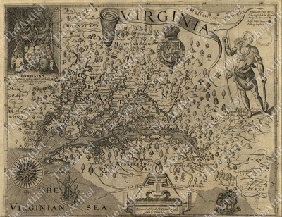
$10.75 Shipping Location: Carmel, United States GIANT VINTAGE 1607 historic JOHN SMITH VIRGINIA MAP OLD ANTIQUE STYLE art print THIS IS A GIANT HIGHLY DETAILED MAP OF VIRGINA AREA CIRCA 1607 THIS PRINT ... moreMEASURES 42"X 54" 107cm x137cm) THIS MAP HAS GREAT DETAIL SEE PHOTOS BELOW THIS IS A MODERN REPRINT PRINTED ON FINE MATTE PAPER This will be printed in its full aspect ratio on high quality paper. using ULTRACHROME K3 INKS which are rated up to 125+ years I do not use cheap inks that will fade in a few months very suitable for framing some images may have a thin white border THEARTTIST will not show up on your print PERFECT FOR YOUR HOME. OFFICE, GAME ROOM, MAN CAVE or GARAGE Thank you for looking. PLEASE FEEL FREE TO ASK QUESTIONS. THANKS. You may be interested in on eBay. THANKS FOR LOOKING Payment Instructions I accept PayPal for payment. I prefer PayPal. I require that payment be made within 3 days of the end of auction. Please Email me if you have any questions before you bid. Happy bidding! See PHOTO above to check EXACTLY what youre bidding on Feedback: I take pride in my feedback and strive for 5 Star Service. If you have a problem. Please email me before leaving bad feedback so that we can work something out. Shipping Instructions US Buyers: I use USPS Mail for most shipping needs- Purchases over $250 Will be sent with Signature Conformation International Buyers: International buyers If you need you can contact me prior to bidding to obtain a shipping quote. International buyers can choose how fast they wish delivery by USPS meaning Global Priority. Air Letter Post or Economy Letter Post. All of my shipping charges vary depending on the weight of the item. I will gladly combne Shipping with any of my other auction. drop me an email before bidding and I will try to respond within 24 hours. Important Notice to International Buyers Import duties. Taxes, and charges are not included in the item price or shipping cost. These charges are assessed and collected by your nation's government and are the buyer's responsibility. Please check with

Buy It Now
$10.75 Shipping Location: Carmel, United States VINTAGE PANORAMIC 1912 KNICKERBOCKER BEER NEW YORK CITY BIRD'S EYE VIEW WALL MAP THIS IS A HIGHLY DETAILED MAP OF NEW YORK CITY. NY ISSUED BY KNICKERBOCKER ... moreBEER 1912 THIS PRINT MEASURES 18"X 24" 46cm x 61cm) THIS MAP HAS GREAT DETAIL SEE PHOTOS BELOW Fine Art Giclee(not a laser print) THIS IS A MODERN REPRINT PRINTED ON FINE ART PAPER not a second or third generation print This will be printed in its full aspect ratio on high quality paper. using ULTRACHROME K3 INKS which are rated up to 125+ years I do not use cheap inks that will fade in a few months very suitable for framing some images may have a thin white border THEARTTIST will not show up on your print PERFECT FOR YOUR HOME. OFFICE, GAME ROOM, MAN CAVE or GARAGE Thank you for looking. PLEASE FEEL FREE TO ASK QUESTIONS. THANKS. You may be interested in on eBay. THANKS FOR LOOKING Payment Instructions I accept PayPal for payment. I prefer PayPal. I require that payment be made within 3 days of the end of auction. Please Email me if you have any questions before you bid. Happy bidding! See PHOTO above to check EXACTLY what youre bidding on Feedback: I take pride in my feedback and strive for 5 Star Service. If you have a problem. Please email me before leaving bad feedback so that we can work something out. Shipping Instructions US Buyers: I use USPS Mail for most shipping needs- Purchases over $250 Will be sent with Signature Conformation International Buyers: International buyers If you need you can contact me prior to bidding to obtain a shipping quote. International buyers can choose how fast they wish delivery by USPS meaning Global Priority. Air Letter Post or Economy Letter Post. All of my shipping charges vary depending on the weight of the item. I will gladly combne Shipping with any of my other auction. drop me an email before bidding and I will try to respond within 24 hours. Important Notice to International Buyers Import duties. Taxes, and charges are not included in the item price or shipping cost. These charges are assessed and co

Buy It Now
$10.75 Shipping Location: Carmel, United States LARGE VINTAGE historic HAWAIIAN SANDWICH ISLANDS 1841 ANTIQUE STYLE MAP print THIS IS A LARGE AND HIGHLY DETAILED MAP OF THE HAWAIAN SANDWICH ISLANDS ... moreCIRCA 1841 THIS PRINT MEASURES 18"X 22" 46cm x56cm) THIS MAP HAS GREAT DETAIL SEE PHOTO BELOW THIS WILL PRINTED ON FINE ART WATERCOLOR PAPER Need this is a different size click the link below to see if I have another size MAPS. This will be printed in its full aspect ratio on high quality paper. using ULTRACHROME K3 INKS which are rated up to 125+ years I do not use cheap inks that will fade in a few months very suitable for framing some images may have a thin white border THEARTTIST will not show up on your print PERFECT FOR YOUR HOME. OFFICE, GAME ROOM, MAN CAVE or GARAGE Thank you for looking. PLEASE FEEL FREE TO ASK QUESTIONS. THANKS. THANKS FOR LOOKING Payment Instructions I accept PayPal for payment. I prefer PayPal. I require that payment be made within 3 days of the end of auction. Please Email me if you have any questions before you bid. Happy bidding! See PHOTO above to check EXACTLY what youre bidding on Feedback: I take pride in my feedback and strive for 5 Star Service. If you have a problem. Please email me before leaving bad feedback so that we can work something out. Shipping Instructions US Buyers: I use USPS Mail for most shipping needs- Purchases over $250 Will be sent with Signature Conformation International Buyers: International buyers If you need you can contact me prior to bidding to obtain a shipping quote. International buyers can choose how fast they wish delivery by USPS meaning Global Priority. Air Letter Post or Economy Letter Post. All of my shipping charges vary depending on the weight of the item. I will gladly combne Shipping with any of my other auction. drop me an email before bidding and I will try to respond within 24 hours. Important Notice to International Buyers Import duties. Taxes, and charges are not included in the item price or shipping cost. These charges are assessed and collected by your nation's governm
Buy It Now
$14.50 Shipping Location: Carmel, United States ISSUED BY KNICKERBOCKER BEER 1912. THIS IS A GIANT AND HIGHLY DETAILED MAP OF NEW YORK CITY, NY. This will be printed in its full aspect ratio on high ... morequality paper. THIS IS A MODERN REPRINT PRINTED ON FINE ART PAPER.

Buy It Now
$10.75 Shipping Location: Carmel, United States GIANT VINTAGE historical EAST BOSTON MASS 1879 OLD ANTIQUE STYLE MAP art print THIS IS A GIANT HIGHLY DETAILED MAP OF BOSTON MASS CIRCA 1879 THIS PRINT ... moreMEASURES 43"X 53" 109cm x 135cm) THIS MAP HAS GREAT DETAIL SEE PHOTOS BELOW Fine Art Giclee(not a laser print) THIS IS A MODERN REPRINT PRINTED ON FINE ART PAPER not a second or third generation print This will be printed in its full aspect ratio on high quality paper. using ULTRACHROME K3 INKS which are rated up to 125+ years I do not use cheap inks that will fade in a few months very suitable for framing some images may have a thin white border THEARTTIST will not show up on your print PERFECT FOR YOUR HOME. OFFICE, GAME ROOM, MAN CAVE or GARAGE Thank you for looking. PLEASE FEEL FREE TO ASK QUESTIONS. THANKS. You may be interested in on eBay. THANKS FOR LOOKING Payment Instructions I accept PayPal for payment. I prefer PayPal. I require that payment be made within 3 days of the end of auction. Please Email me if you have any questions before you bid. Happy bidding! See PHOTO above to check EXACTLY what youre bidding on Feedback: I take pride in my feedback and strive for 5 Star Service. If you have a problem. Please email me before leaving bad feedback so that we can work something out. Shipping Instructions US Buyers: I use USPS Mail for most shipping needs- Purchases over $250 Will be sent with Signature Conformation International Buyers: International buyers If you need you can contact me prior to bidding to obtain a shipping quote. International buyers can choose how fast they wish delivery by USPS meaning Global Priority. Air Letter Post or Economy Letter Post. All of my shipping charges vary depending on the weight of the item. I will gladly combne Shipping with any of my other auction. drop me an email before bidding and I will try to respond within 24 hours. Important Notice to International Buyers Import duties. Taxes, and charges are not included in the item price or shipping cost. These charges are assessed and collected by your nation'
$3.95 Shipping Location: Clarkston, United States A very interesting and decorative world map on a North Polar projection derived from Jacques Cassini’s projection published in 1696. Australia extends ... moreacross sixty degrees so that the eastern shore lies north of New Zealand.
$3.95 Shipping Location: Clarkston, United States Map Size: 10"x16". This is a reproduction of the original map. 16"x24" and 23"x35".
$3.95 Shipping Location: Clarkston, United States Detailed map of part of Canada and Greenland, focusing on the Eskimo Tribes in the region. They are rolled and placed into a rigid tube or box. This is ... morea modern reproduction of the original map. Map Size: 2 x 11"x12".
Buy It Now
$3.95 Shipping Location: Clarkston, United States The results are very high quality and convincing. 3302000 Ferry, Julio Popper. Double your traffic. Features of this DVD. Works with all versions of Windows ... moreincluding 3.1, 95, 98, 2000 or XP. Plan Du Port Del Manzanillo.
$3.95 Shipping Location: Clarkston, United States 1878 Map of the Anthracite Coal Fields in Eastern Pennsylvania. Shows the 4 major coal fields of Eastern Pennsylvania, with an inset map showing the market ... moreoutlets to New York, Baltimore and Philadelphia.
Buy It Now
$12.45 Shipping Location: Saint Petersburg, United States
Buy It Now
$12.70 Shipping Location: Sharpsburg, United States
$3.95 Shipping Location: Clarkston, United States This is a modern reproduction of the original map. They are rolled and placed into a rigid tube or box. Map Size: 9"x16".
$3.95 Shipping Location: Clarkston, United States Inset of Indian Territory in Northeastern Oklahoma. This is a modern reproduction of the original map. Map Size: 9"x16".
$3.95 Shipping Location: Clarkston, United States Map Size: 11"x15". The map also traces historic conflicts: Morgan’s Raid is prominently depicted, as well as many events from the Revolutionary War and ... morethe War of 1812. A Map of Indiana Showing its History, Points of Interest.
$3.95 Shipping Location: Clarkston, United States This is a modern reproduction of the original map. Map Size: 11"x16". 16"x24" and 23"x34".
$3.95 Shipping Location: Clarkston, United States A deep dive into cultural sea of the native Southwest, covering parts of the four corners states. A rare and fascinating anthropological work. This is ... morea modern reproduction of the original map. Map Size: 9"x16".
$3.95 Shipping Location: Clarkston, United States The Catawba Deerskin Map was a map drawn on deerskin and presented to Francis Nicholson, the colonial governor of South Carolina, around 1721. The Catawba ... moreDeerskin Map. In a 2012 Edelson compares the Catawba Deerskin map to a modern subway map, in which depicting accurate physical space is less important than communicating the structure of the network.
Buy It Now
$15.27 Shipping Location: CLEVEDON, United Kingdom
$3.95 Shipping Location: Clarkston, United States The map is based upon the studies of the renowned anthropologist and ethnologist George Peter 'Pete' Murdock (1897 - 1985). The map has here been updated ... moreand revised with the studies of the linguist George L. Trager (1906 - 1992).
Buy It Now
Free Shipping Location: Corpus Christi, United States Nova Tabula. Map State 3 facsimile copper engraving, hand colored with latin text. To fill in such a large blank space, Blaeu uses an inset map of Groenlan ... more(Greenland), Islandia (Iceland), and the mythical island of Frislandia, which first appeared in the influential Zeno map of 1558.
$3.95 Shipping Location: Clarkston, United States The Golden Rule Mines are colored and labeled "Golden Rule". This is a reproduction of the original map. Shows boundaries of mining claims, locations ... moreof tunnels and mine shafts.
$3.95 Shipping Location: Clarkston, United States Insets: Alaska -- Mission Ind. in California -- Indian Territory. This is a modern reproduction of the original map. Map Size: 10"x16".
Buy It Now
$6.75 Shipping Location: Baraboo, United States
Buy It Now
Free Shipping Location: Merritt Island, United States Relief shown pictorially on bird's-eye views. We are committed to getting your map to you when you need it.
Buy It Now
$4.00 Shipping Location: Chicago, United States The Voyages of Sir Francis Drake 1585 24 X 20 This is a great Classic Map originally published circa 1589. This Map shows Sir Francis Drake's voyage ... moreto the new world during his West Indian voyage of 1585-1586. This map is a vintage stylistic print of the time and features his voyage from Europe to ports in South America. The Caribbean and North America. This poster. Which evokes the vivid images of a simpler time, is a custom reproduction printed on 68lb Heavyweight Enhanced Matte Art Paper. This Historic Art Print is suitable for framing. Mounting or direct display on any wall!
Buy It Now
$21.05 Shipping Location: Rosny Park, Australia This art print displays sharp, vivid images with a high degree of colour accuracy. With brilliant colour and a high level of detail, our reproductions ... moreare an excellent option for the art lover. Nearly all of our products are available in multiple size formats ranging from A4 to Giant (way beyond A1).
|
|
|
|
1929 map: Indians of North America & South States Catawba deerskin "A map, somet
Map Description: 1929 map Catawba deerskin map"A map. Sometimes known as the Catawba Deerskin Map, describing the situation of the several nations of the Indians to the north west of South Carolina. This map describing the scituation sic of the several nations of Indians to the NW of South Carolina was coppyed sic from a draught drawn& painted on a deer skin by an Indian Cacique and presented to Francis Nicholson Esqr. Governor of South Carolina by whom it is most humbly dedicated to his Royal Highness George, Prince of Wales. Size: Approximately 2 foot x 18 inches. 61cm x 46cm) Close up of Map Quality: If you're not happy with the map when it arrives. Return it with no questions asked for a full refund of purchase price + S/H! This Map is an Archival Quality Reproduction created directly from the original map using archival ... moreinks rated not to fade for 200+ years on premium thick semi matte paper. Actual Map is sharper and much more detailed than image shown. The resolution is of the highest quality. Frame not included. Shipping: Tracking Number& Insurance: included for free for all domestic orders! Packaging: heavy duty poster tube. Combined shipping is free for each additional Map paid for at the same time. International shipping: only $7.99 no matter how many Maps! END FOOTER/
|
|
|
Antique Map - North America - 1755 - Reproduction
Antique Map- North America- 1755- Reproduction Antique Map- North America- 1755- Reproduction Originally published in eight sections and called the Mitchell Map. This interesting early map of the American colonies is recognized by cognoscenti as the most important map of America ever published. At the time boundaries were in hot dispute between England and France resulting in two versions of the map, one French, one English, with some essential differences. But the buffalo herds, Native American tribes and other highly interesting details were the same in both. Originals of this map are very rare and sell in excess of $30,000. Get close and check out the many incredible details. Travel back to a time when North America was gradually becoming colonized. This wall hanging map measures: 78 3/4" by 56" It has french finished cherry ... morewood slats at the top and bottom of the map. Hanging hardware is included. Manufacturer: Authentic Models andale andalesell. Payment Options: PayPal Shipping Options: Domestic shipping: Fixed Shipping Charges. Shipping Carrier Domestic Usps First-Class $0.00 I will ship to: United States a pretty image. templates with Vendio Sales Manager. Vendio provides powerful selling automation for sellers of all sizes. Click Here. Double your traffic. Get Vendio Gallery- Now FREE!
|
|
|
Southeast North America Original Signed Oil on Canvas Painting Novica
eb2206 eb151725 nv25602 nv21703. TL3 SL23. Southeast North America' By I was captivated by the dance of the brush on the canvas and the smell of oil paints. With each day that passed. I became more absorbed in painting. Beautifully painted by hand. This antique style map is inspired by those drawn by Abraham Ortelius– cartographer to the Spanish King Felipe II. Yet Rivero adds the states of the southeastern U.S.A. Galleons with billowing sails ply the Atlantic and venture into the Gulf of Mexico. Rivero gives the painting an antique crackled finish. Titled"Sudeste de Norte América" in Spanish. Item Details. Size: 24.0 inches W x 24.0 inches H. Weight: 0.73 pounds, Materials: Oil and acrylic on canvas, Additional Info: Arrives unframed. Unstretched. Signed by the artist. Requires special handling- allow an extra 14 days ... morefor delivery Photos are representative of the item being offered. But are not necessarily of the exact item you would receive. As is the nature of handcrafted items, there may be very slight variations from one piece to the next. Suggested Retail: US $805.95 Novica bypasses all traditional middlemen to offer the best prices on the highest quality works direct from the region of origin. Shipping. Shipping to Lower 48 United States Shipping Service, Shipping Cost, Delivery Time, Standard to Lower 48 United States, $6.00 3 to 8 business days, Expedited to Lower 48 United States, $20.00 1 to 2 business days, We will ship to most destinations See chart below for the additional cost of shipping to other destinations: Shipping Destination, Total Shipping, Delivery Time, Australia $40.00 3 to 10 business days, Canada $25.00 3 to 10 business days, Puerto Rico& US Virgin Islands Standard $8.00 5 to 10 bus. days, Puerto Rico& US Virgin Islands Expedited 16.00, 2 to 5 business days, United Kingdom $35.00 3 to 10 business days, USA(Alaska or Hawaii) Standard Same as Standard $6.00 5 to 10 business days, USA(Alaska or Hawaii) Expedited 20.00, 2 to 4 business days, Combined Shipping for
|
|
|
Vintage Map North South America Art Locket Silver Pendant Necklace Jewelry Gift
North South American Map Art Locket Silver Plate Necklace ~This listing is for a fabulous Altered Art locket ~North South America World Map~. This artful design is made with an archival quality photo applied to a smooth silver plated brass locket with an antiqued patina. A specially formulated UV safe waterproof. Scratch-resistant coating which will last for many years& will not yellow or crack has been hand applied to each pendant. The locket hangs from a softly finished silver plated ball chain necklace that can easily be shortened to your ideal length. A stunning pendant and creative place to keep what you cherish close to your heart ~ Details: Locket- Antique silver plated brass. 32MM Chain- 24" Silver Plated Ball Chain ~ Please Note ~ ~ This listing is for the item that is described only.any other jewelry or clothing that this ... moreitem is displayed with in the photographs are listed in seperate. Individual listings. If you need help locating one of the other items that are displayed with this one please don't hesitate to ask for assistance ~
|
|
|
1816 LUCAS ATLAS MAP genealogy family history NORTH AMERICA 6
This Auction is for an Unframed Modern REPRINT of an Antique Map This map is printed on specially coated. Matte finish, paper for sharper print quality and colors that are vivid. Original Atlas Title A New and Elegant General Atlas Containing Maps of each of the United States. Baltimore. Printed and Published By Fielding Lucas Junr. and Philip H. Nicklin Philadelphia. Copyright Secured. G. Fairman. 1816. Approximate Image Size 16.5 X 21 inches WE HAVE MANY HISTORIC REPRINT MAPS AND OTHER ITEMS ON MANY DIFFERENT SUBJECTS Please check out store for additonal products Powered by The free listing tool. List your items fast and easy and manage your active items.
|
|
|
1786 map of British North America, with the West India Islands View 1 of 2
Map Description: 1786 A new map of North America. With the West India Islands. Divided according to the preliminary articles of peace, signed at Versailles, 20, Jan. 1783. Wherein are particularly distinguished the United States and the several provinces, governments&ca. which compose the British dominions; laid down according to the latest surveys and corrected from the original materials, of Goverr. Pownall, Membr. of Parliamt. 1783. Relief shown pictorially. Prime meridian: London and Ferro. Size: Approximately 2 foot x 18 inches. 61cm x 46cm) Frame not included. Close up of Map Quality: Archival Quality Giclée Reproduction Created using Epson Stylus Pro 7900: 11 UltraChrome HDR pigment inks offer exeption quality for true archival printing Archival Rated to last up to 200 years without fading Shipping: Tracking Number& Insurance: ... moreincluded for free for all domestic orders! Packaging: heavy duty poster tube. Combined shipping is free for each additional map paid for at the same time. International shipping: only $7.99 no matter how many Maps! END FOOTER/
|
|
|
1784 map North America British, Spain & French territories Bowless new and accur
Map Description: 1784 map Bowless new and accurate map of North America and the West Indies. Exhibiting the extent and boundaries of the United States, the British dominions, and territories possessed in that quarter by the Spaniards, the French, and other Europeanpowers. The whole compiled and laid down from the best authorities, regulated and divided according to the Preliminary Articles of Peace signed at Versailles 20th. Jany. 1783. Scale ca. 1:5,400,000. Hand colored. Relief shown pictorially. Size: Approximately 2 foot x 18 inches. 61cm x 46cm) Frame not included. Close up of Map Quality: Archival Quality Giclée Reproduction Created using Epson Stylus Pro 7900: 11 UltraChrome HDR pigment inks offer exeption quality for true archival printing Archival Rated to last up to 200 years without fading Shipping: Tracking Number& Insurance: ... moreincluded for free for all domestic orders! Packaging: heavy duty poster tube. Combined shipping is free for each additional map paid for at the same time. International shipping: only $7.99 no matter how many Maps! END FOOTER/
|
|
|
1784 French Map of North America & United States Charte uber de XIII Vereinigte
Map Description: 1784 map Charte uber de XIII Vereinigte Staaten von Nord America. Entworfen durch F. L. Gussefeld und hrsg. Von den Homnnischen Erben. Homann Erben(Firm) Hand colored. Size: Approximately 2 foot x 18 inches. 61cm x 46cm) Frame not included. Close up of Map Quality: Archival Quality Giclée Reproduction Created using Epson Stylus Pro 7900: 11 UltraChrome HDR pigment inks offer exeption quality for true archival printing Archival Rated to last up to 200 years without fading Shipping: Tracking Number& Insurance: included for free for all domestic orders! Packaging: heavy duty poster tube. Combined shipping is free for each additional map paid for at the same time. International shipping: only $7.99 no matter how many Maps! END FOOTER/
|
|
|
1811 map of North America A new of North Amerifrom the latest authorities / by J
Map Description: 1811 A new map of North America from the latest authorities/ by John Cary. Engraver. Size: Approximately 2 foot x 18 inches. 61cm x 46cm) Frame not included. Close up of Map Quality: Archival Quality Giclée Reproduction Created using Epson Stylus Pro 7900: 11 UltraChrome HDR pigment inks offer exeption quality for true archival printing Archival Rated to last up to 200 years without fading Shipping: Tracking Number& Insurance: included for free for all domestic orders! Packaging: heavy duty poster tube. Combined shipping is free for each additional map paid for at the same time. International shipping: only $7.99 no matter how many Maps! END FOOTER/
|
|
|
1803 Map of North America A of North Ameri; Outline of North America, in corresp
Map Description: 1803 A map of North Ameri; Outline of North America. In correspond to the map. North Ameri, Maps. North America. Cartographer: Luffman, J. John) 1756-1846. Size: Approximately 2 foot x 18 inches. 61cm x 46cm) Frame not included. Close up of Map Quality: Archival Quality Giclée Reproduction Created using Epson Stylus Pro 7900: 11 UltraChrome HDR pigment inks offer exeption quality for true archival printing Archival Rated to last up to 200 years without fading Shipping: Tracking Number& Insurance: included for free for all domestic orders! Packaging: heavy duty poster tube. Combined shipping is free for each additional map paid for at the same time. International shipping: only $7.99 no matter how many Maps! END FOOTER/
|
|
|
1780s North America Map British & Spanish territories A correct of the United St
Map Description: 1780s map A correct map of the United States of North America; including the British and Spanish territories. Carefully laid down agreeable to the treaty of 1784. Scale ca. 1:10,000,000. Prime meridian: London. Relief shown pictorially. Size: Approximately 2 foot x 18 inches. 61cm x 46cm) Frame not included. Close up of Map Quality: Archival Quality Giclée Reproduction Created using Epson Stylus Pro 7900: 11 UltraChrome HDR pigment inks offer exeption quality for true archival printing Archival Rated to last up to 200 years without fading Shipping: Tracking Number& Insurance: included for free for all domestic orders! Packaging: heavy duty poster tube. Combined shipping is free for each additional map paid for at the same time. International shipping: only $7.99 no matter how many Maps! END FOOTER/
|
|
|
Map 13 original colonies of North America in a decorative fo cabinet
Good condition
|
|
|
1851 map of Indians of North America, West, US of the upper Great Plains and Roc
Map Description: 1851 Map of the upper Great Plains and Rocky Mountains region/ respectfully presented to Col. D.D. Mitchell by P.J. de Smet. Relief shown by hachures. Size: Approximately 2 foot x 18 inches. 61cm x 46cm) Frame not included) Close up of Map Quality: Archival Quality Giclée Reproduction Created using Epson Stylus Pro 7900: 11 UltraChrome HDR pigment inks offer exeption quality for true archival printing Archival Rated to last up to 200 years without fading Shipping: Tracking Number& Insurance: included for free for all domestic orders! Packaging: heavy duty poster tube. Combined shipping is free for each additional map paid for at the same time. International shipping: only $7.99 no matter how many Maps! END FOOTER/
|
|
|
1861 Map United States of North America, Canada of the United States of North Am
Map Description: 1861 Map of the United States of North America. Upper& Lower Canada, New Brunswick, Nova Scotia& British Columbia. Mexico, Cuba, Jamaica, St. Domingo and the Bahama Islands. General map showing state and international boundaries, railroads, cities, rivers, and relief by hachures. Two colors are used to differentiate between Union and Confederate states. Cartographer: Ettling, Theodor, b. 1823. Size: Approximately 2 foot x 18 inches. 61cm x 46cm) Close up of Map Quality: This Map is an Archival Quality Reproduction created directly from the original map using archival inks rated not to fade for 200+ years on premium thick semi matte paper. Actual Map is sharper and much more detailed than image shown. The resolution is of the highest quality. Frame not included. Shipping: Tracking Number& Insurance: included for ... morefree for all domestic orders! Packaging: heavy duty poster tube. Combined shipping is free for each additional map paid for at the same time. International shipping: only $7.99 no matter how many Maps! END FOOTER/
|
|
|
1862 railroad map of portions of North America Coltons rail road and military of
Map Description: 1862 map Coltons rail road and military map of the United States. Mexico, the West Indies, c. Includes census information for 1860. Relief shown by hachures. Insets: Coltons map of the Americas, Africa and a portion of Europe showing the Atlantic and part of the Pacific oceans. New Orleans and delta of the Mississippi, Louisiana. Mobile harbor, Alabama. Key West and Tortugas, Florida reefs. Wilmington and vicinity, N. Carolina. Beaufort and vicinity, N. Carolina. Norfolk, fortress Monroe, James River, Richmond, Petersburg&c&c. Map of Charleston, Port Royal& Savannah vicinities. Washington, Manassas Junction, Harpers Ferry, Baltimore, Annapolis&c&c. Size: Approximately 2 foot x 18 inches. 61cm x 46cm) Close up of Map Quality: This Map is an Archival Quality Reproduction created directly from the original ... moremap using archival inks rated not to fade for 200+ years on premium thick semi matte paper. Actual Map is sharper and much more detailed than image shown. The resolution is of the highest quality. Frame not included. Shipping: Tracking Number& Insurance: included for free for all domestic orders! Packaging: heavy duty poster tube. Combined shipping is free for each additional map paid for at the same time. International shipping: only $7.99 no matter how many Maps! END FOOTER/
|
|
|
1836 Map Indian tribes of North America about 1600 AD of the Indian tribes of No
Map Description: 1836 Map of the Indian tribes of North America. About 1600 A.D. along the Atlantic, about 1800 A.D. westwardly/ published by the Amer. Antiq. Soc. From a drawing by Hon. A. Gallatin. Pendletons Lithography. From: American Antiquarian Society. Transactions and collections. Vol. 2, 1836, fol. P. 264. Relief shown pictorially. Hand colored to show the location of Indian tribes and 11 linguistic families. Cartographer: Gallatin, Albert, 1761-1849. Size: Approximately 2 foot x 18 inches. 61cm x 46cm) Frame not included. Close up of Map Quality: Archival Quality Giclée Reproduction Created using Epson Stylus Pro 7900: 11 UltraChrome HDR pigment inks offer exeption quality for true archival printing Archival Rated to last up to 200 years without fading Shipping: Tracking Number& Insurance: included for free for all domestic ... moreorders! Packaging: heavy duty poster tube. Combined shipping is free for each additional map paid for at the same time. International shipping: only $7.99 no matter how many Maps! END FOOTER/
|
|
|
1639 map: Atlantic coast, North America De Eylanden en Vastelanden van Westindie
Frame not included) Map Description: 1639 map De Eylanden en Vastelanden van Westindien/ bischrytvendoor Joan Vingboons. Pen and ink and watercolor. Described in Terrae incognitae. V. xvi, 1984. Richard W. Stephensons The Henry Harrisse collection¿ p. 40; the first volume has binders title"Manuscript maps of the West Indies drawn by Joan Vingboons in 1639. Shows the coasts of North America and South America from Virginia through the Yucatan Peninsula in Mexico to Guiana in South America highlighting Cuba, the island of Hispaniola and the West Indies. No. 190 in Quatrie`me centenaire de la decouverte de lAmerique. Catalogue des documents geographique exposes a`¿ la Bibliothe`que nationale. Paris, 1802. Size: Approximately 2 foot x 18 inches. 61cm x 46cm) Archival Quality Reproduction Close up of Map Quality: Shipping: Tracking ... moreNumber& Insurance included for all domestic orders Packaging: heavy duty poster tube. END FOOTER/
|
|
|
ca 1850? map: North America Lamerique centrale / 1 jou ?, Henri II, Mr. Jomard.
Frame not included) Map Description: ca 1850? map Lamerique centrale/ 1 jou? Henri II, Mr. Jomard. Oriented with south to the top. Pen and ink and red paint on tracing paper. Reversed in lower left: 1556? Size: Approximately 2 foot x 18 inches. 61cm x 46cm) Archival Quality Reproduction Close up of Map Quality: Shipping: Tracking Number& Insurance included for all domestic orders Packaging: heavy duty poster tube. END FOOTER/
|
|
|
1816 map of Central America Spanish North America, southern part / drawn & engra
Frame not included) Map Description: 1816 Spanish North America. Southern part/ drawn& engraved by W. D. Lizars. In upper right margin: No. 59. From A New general atlas¿ Printed by G. Ramsay and company, for J. Thomson and company; London, Baldwin, Cradock, and Joy; etc. etc. 1817. Size: Approximately 2 foot x 18 inches. 61cm x 46cm) Archival Quality Reproduction Close up of Map Quality: Shipping: Tracking Number& Insurance included for all domestic orders Packaging: heavy duty poster tube. END FOOTER/
|
|
|
1755 map of British North America An accurate of the British colonies in North
frame not included) Map Description: 1755 map: An accurate map of the British colonies in North America bordering on the river Ohio. Hand colored. Relief shown pictorially. Size: Approximately 2 foot x 18 inches. 61cm x 46cm) Archival Quality Reproduction Close up of Map Quality: Shipping: Tracking Number& Insurance included with all domestic orders Packaging: heavy duty poster tube. END FOOTER/
|
|
|
1750s map of North America "from the latest discoveries" An Accurate of North Am
Frame not included) Map Description: 1750s map An Accurate map of North America from the latest discoveries. Relief shown pictorially. Shows"Degrees west from London. Also shows colonies. A few cities and towns, and Indian tribal territory. North America Maps Early works to 1800. Size: Approximately 2 foot x 18 inches. 61cm x 46cm) Archival Quality Reproduction Close up of Map Quality: Shipping: Tracking Number& Insurance included for all domestic orders Packaging: heavy duty poster tube. END FOOTER/
|
|
|
1912 ORIGINAL ANTIQUE MAP European Colonisation in North America to 1700 66
This Auction is for an Unframed ORIGINAL ANTIQUE MAP NOT a reproduction as detailed below. I have many additional maps from this volume Please see my store for what is available. The prints are much sharper that the image shown here. Taken from: The Cambridge Modern History Volume 14(Atlas Volume) Published 1912 Map Size 9 X 12 inches WE HAVE MANY HISTORIC MAPS. PRINTS AND OTHER ITEMS ON MANY DIFFERENT SUBJECTS Please check out store for additonal products IF YOU ARE UNHAPPY WITH YOUR PURCHASE SIMPLY RETURN IT AND WE WILL REFUND YOUR MONEY. Powered by The free listing tool. List your items fast and easy and manage your active items.
|
|
|
1771 map of Northeastern States A new and accurate of part of North-America, com
Frame not included) Map Description: 1771 A new and accurate map of part of North-America. Comprehending the provinces of New England, New York, Pensilvania, New Jersey, Connecticut, Rhode Island& part of Virginia, Canada and Hallifax, for the illustration of Mr. Peter Kalms travels. J. Gibson, sculp. Shows provinces, towns and cities, forts, some residences, landmarks, salt and coal deposits, swamps, grasslands, waterfalls, Indian villages, and relief. Relief shown pictorially. Covers the area from Quebec to lower Chesapeake Bay and west along the St. Lawrence River and the Great Lakes to Fort Detroit. Size: Approximately 2 foot x 18 inches. 61cm x 46cm) Archival Quality Reproduction Close up of Map Quality: Shipping: Tracking Number& Insurance included for all domestic orders Packaging: heavy duty poster tube. END FOOTER/
|
|
|
1777 Map A New and accurate of the present seat of war in North America
frame not included) Map Description: 1777 A New and accurate map of the present seat of war in North America. Comprehending New Jersey, Philadelphia, Pensylvania, New-York, c. Seat of war in North America. Size: Approximately 2 foot x 18 inches. 61cm x 46cm) Archival Quality Reproduction Close up of Map Quality: Shipping: Tracking Number& Insurance included with all domestic orders Packaging: heavy duty poster tube. END FOOTER/
|
|
|
1763 map of British, America A new of the British Dominions in North America; wi
Frame not included) Map Description: 1763 A new map of the British Dominions in North America; with the limits of the governments annexed thereto by the late Treaty of Peace. And settled by Proclamation, October 7th 1763. Engraved by T. Kitchin, geogr. Engraved for the History of the War in the Annual Register, and to be placed at the end of the volume for 1763. Longit. West from London. Size: Approximately 2 foot x 18 inches. 61cm x 46cm) Archival Quality Reproduction Close up of Map Quality: Shipping: Tracking Number& Insurance included for all domestic orders Packaging: heavy duty poster tube. END FOOTER/
|
|
|
1856 Johnston map of Geological map United States North America 9
This Auction is for an Unframed MODERN REPRINT of an Antique Map as detailed below. This map is reproduced on specially coated. Matte finish, paper for sharper print quality and colors that are vivid. These maps are created from VERY high resolution uncompressed TIFF files(averaging 200+ megabytes) and are much sharper that the image shown here. Description. Approximate Image Size 16.5 X 20 inches, Original Atlas Title The physical atlas of natural phenomena by Alexander Keith Johnston. F.R.S.E. F.R.G.S. F.G.S. A new and enlarged edition. William Blackwood and Sons, Edinburgh and London, MDCCCLVI. The Author reserves the right of translation] WE HAVE MANY HISTORIC MODERN REPRINT MAPS AND OTHER ITEMS ON MANY DIFFERENT SUBJECTS Please check out store for additonal products FREE SHIPPING BY MAIL(GENERALLY 2 TO 5 DAY DELIVERY) FOR ANY NUMBER ... moreOF MAPS SHIPPED IN THE US. SHIPPING IS $15 PLUS $1 FOR EACH ADDITIONAL MAP TO ANYWHERE ELSE IN THE WORLD. WE SHIP ALL MAPS ROLLED IN A MAILING TUBE TO PROTECT THE MAP. IF YOU ARE UNHAPPY WITH YOUR PURCHASE SIMPLY RETURN IT AND WE WILL REFUND YOUR MONEY. Ad copyright 2014 All Rights Reserved Powered by The free listing tool. List your items fast and easy and manage your active items.
|
|
|
1732 Grierson and Moll Map of North America The Codfish Map Reproduction Nice
This is a modern day reproduction of the 1732 Grierson and Moll Map of North America known as the Codfish map. Unfortunately; for me this is not an antique map. But a modern reproduction of a very famous and valuable map. This map appears to be a high quality print. Paper is thick and textured.28" by 24" I cannot see any pixelation which leads me to believe that this is not one of the run of the mill reproductions, however I am no map expert and I was not able to find out who printed this and when. RcmdId ViewItemDescV4,RlogId p4%60bo7%60jtb9%3Fuk.rp*4a24%60%3C%3E-14a64e764d7-0x10f-
|
|
|
North America Map, Matthew Seutter 1735, Vintage Penn Print G364
MAP OF NORTH AMERICA MATTHEW SEUTTER 1735 Vintage Penn Prints G364 20 x 26 inches ships in priority mailing tube smudge in left top margin. Old price in pencil right top corner
|
|
|
French Map of North America, Septemtrion 1683 Carte Nouelle France, Hennepin
Carte de la Nouuelle France et de la Louisiane Septemtrion. North America 1685 Map by Reverend Pere Louis Hennepin 11 x 17 reproduction
|
|
|
North America Chart, America Septentrionalis, R. Elstracke Sculpist 1625 Map
NORTH AMERICA- AMERICA SEPTENTRIONALIS Chart 1625. R. Elstracke Sculpist interesting features such as the complete separation of California and the position of the Tortugas and can you find Bermuda? 11 x 14 reproduction
|
|
|
1860 JOHNSON poster of antique map of North America 6
Click Here. Double your traffic. Get Vendio Gallery- Now FREE! This Auction is for an Unframed MODERN REPRINT of an Antique Map as detailed below. This map is reproduced on specially coated. Matte finish, paper for sharper print quality and colors that are vivid. These maps are created from VERY high resolution uncompressed TIFF files(averaging 200+ megabytes) and are much sharper that the image shown here. Description. Approximate Image Size 16.5 X 21.5 inches, Original Atlas Title Johnson's New Illustrated(Steel Plate) Family Atlas. With Descriptions, Geographical, Statistical, And Historical. Compiled, Drawn, and Engraved Under The Supervision Of J.H. Colton And A.J. Johnson. New York: Johnson And Browning, Formerly(Successors To J.H. Colton And Company, No. 133 Nassau Street. 1860. Entered. One Thousand Eight Hundred and Sixty, by ... moreJohnson& Browning. Virginia. WE HAVE MANY HISTORIC REPRINT MAPS AND OTHER ITEMS ON MANY DIFFERENT SUBJECTS Please check out store for additonal products NO ADDITIONAL SHIPPING ON MULTIBLE ITEM ORDERS-FREE SHIPPING BY MAIL(GENERALLY 2 TO 5 DAY DELIVERY) FOR ANY NUMBER OF MAPS SHIPPED IN THE US. SHIPPING IS $15 FOR THE FIRST AND $1 FOR EACH FOR ADDTIONAL MAPS TO ANYWHERE ELSE IN THE WORLD. WE SHIP ALL MAPS ROLLED IN A MAILING TUBE TO PROTECT THE MAP. IF YOU ARE UNHAPPY WITH YOUR PURCHASE SIMPLY RETURN IT AND WE WILL REFUND YOUR MONEY. Ad copyright 2013 All Rights Reserved Powered by The free listing tool. List your items fast and easy and manage your active items.
|
|
|
Vintage North America 1694 Map Archival Quality Reproduction Print
Title: North America 1694 Giclée reproduction print on premium archival canvas. Canvas Size: 22" X 26" Ink: Ultrachrome ink( Which will last over 100 yrs. indoors) There is approximately 2 inches of blank canvas around the image. This is included in the canvas size. The canvas can be stretched. Framed or displayed as a poster. It can also can be lacquered or varnished. The canvas has excellent crack resistance when stretched. Ships rolled in tube Priority Mail with tracking number and insurance. Satisfaction guaranteed. Buy with confidence!
|
|
 |