|
|
Order by: Available to: eBay Affiliate Links
|

Buy It Now
$9.94 Shipping Location: GLASGOW, United Kingdom BLACKBURN& HALIFAX Antique Map 1903 by Bartholomew; Burnley. Clitheroe, Darwen Print Description: BLACKBURN& HALIFAX Antique Map 1903 by Bartholomew; ... moreBurnley. Clitheroe, Darwen Size: The Size of the print/map not including margins is approximately 21x16 inches. Cartographer: Map by John Bartholomew. Provenance: Drawn. Engraved, Printed and Published at The Edinburgh Geographical Institute 1903. Taken from The Survey Atlas of England and Wales, designed by and prepared under the direction of JG Bartholomew. Authenticity: This is a guaranteed genuine antique print. We do not deal in facsimiles or reproductions of any kind. Condition: Very Good; Suitable for framing. We grade all prints individually into four levels- Excellent. Very Good, Good, and Fair. Generally prints in excellent condition are free from foxing, rips,tears or folds. Very Good prints may have some minor foxing or spotting, however this will mainly be confined to the margins. Good and fair may have more general foxing. We try to represent all the images to the best of our ability, and we ask you to check the above scans before purchasing Payment: PayPal is our only accepted method of payment. We accept PayPal payments from buyers all over the world. PayPal is the safest. Easiest and quickest way to make online purchases. If you are purchasing multiple items, please add all the items to your shopping basket before proceeding to the checkout. If you do not already have a PayPal account, simply click on the'Buy It Now' button and follow the eBay checkout instructions. You will then be able to enter your card details in order to pay via PayPal even if you do not already have a PayPal account. Paying via PayPal also ensures that your purchase is fully protected and guaranteed. Returns Policy: If for any reason you are not satisfied with your order we will gladly accept a return for refund or credit. If you wish to return goods you MUST inform us within 14 days of receipt of your order. Please do not return goods without prior consent. Al
Buy It Now
$4.50 Shipping Location: Slingerlands, United States This is an Army Map Service map (AMS V821) of Pitcher from the 1940's (printed 1946-50), showing south and east to McDonough. The Otselic River is on ... morethe upper left. 22x29 1:25,000.
Buy It Now
$5.00 Shipping Location: Canada DATE OF ISSUE: 1910. ORIGIN OF THE MAP: ".
Buy It Now
$6.90 Shipping Location: Audubon, United States It is an old, original map that was rescued from an unusable atlas. You will receive the exact antique map in the photos.
Buy It Now
$9.95 Shipping Condition: Unspecified Location: LONDON, United Kingdom Title of the map:'Moulins'. PROVENANCE: "Southern France including Corsica"; by Karl Baedeker, Published by Karl Baedeker, London: 5th Edition. Antique ... morecolour map; Scale 1:16,650, 1907. DATE PRINTED: 1907.
Buy It Now
$6.21 Shipping Location: WALSALL, United Kingdom It is a rare and highly sought-after piece, perfect for collectors and history enthusiasts alike. The map is in excellent condition and features intricate ... moredetails of the surrounding areas, making it a valuable addition to any antique or map collection.
Buy It Now
$18.66 Shipping Location: CHICHESTER, United Kingdom Colour: Uncoloured. The engraving details the surrounding topography including churches, rivers, bridges, pastures, woods, forests and hills. Date: 1782.
Buy It Now
$6.95 Shipping Location: Dover, United States Flandre Francois, Picardie et Artois, Isle de France, Orleanois, Champagne, Lorraine, et Alsace. Issued c. 1760, Paris by Vaugondy. Mid 18th century engraved ... moremap with lovely hand color.
Buy It Now
Free Shipping Location: Netherlands Description: This attractive original old antique print / plate originates from: 'Ausführliche und grundrichtige Beschreibung der Freyvereinigten Staaten ... moreund Spannischen Niederlanden, in gewisse und sonderbare XVII Länder abgetheilet.', published by C. Riegel, Frankfurt, Leipzig, 1691. Artists and Engravers: Published by Christoff Riegel (?-1714), the famous publisher from Nuremberg, Germany with branches in Frankfurt and Leipzig.

Buy It Now
$9.95 Shipping Condition: Unspecified Location: LONDON, United Kingdom Hendon and Child's Hill Vintage colour map. 1913 Title of map: Hendon and Child's Hill' The image below shows an enlarged cross section from ... morethe centre of the map to show the level of printed detail: DATE PRINTED: 1913 IMAGE SIZE: Approx 21.5 x 27.0cm. 8.5 x 10.5 inches(Medium) ARTIST/CARTOGRAPHER/ENGRAVER: John Bartholomew PROVENANCE: Handy Reference Atlas of London and Suburbs" by J. G. Bartholomew; Published by John Walker& Co. Ltd, London. Second edition. Please note that virtually all antique and vintage maps and prints have been extracted from books, atlases or newspapers. TYPE: Vintage colour map VERSO: There are images and/or text printed on the reverse side of the picture. In some cases this may be visible on the picture itself(please check the scan prior to your purchase) or around the margin of the picture CONDITION: Good; suitable for framing. However. Please note: This map was originally printed as two separate pages which have been professionally joined to form a single sheet. Please check the scan for any blemishes prior to making your purchase. Virtually all antiquarian maps and prints are subject to some normal aging due to use and time which is not obtrusive unless otherwise stated. I offer a no questions asked return policy- see below. AUTHENTICITY: This is an authentic historic print. Published at the date stated above. I do not offer reproductions. It is not a modern copy. The term'original' when applied to a print means that it was printed at the first or original date of publication; it does not imply that the item is unique. Print' means any image created by applying an inked block to paper or card under pressure by any method including wood engraving, steel engraving, copperplate, wood cut and lithography. REMARKS: FRANCE: Gravures et Cartes anciennes. DEUTSCHLAND: Alte Lankarten und Stadt ansichten. ITALIA: Stampe& Mappe antiche. ESPAÑA: Mapas antiquos y impresiones antiguas. E and OE. Force Majeure. English law shall apply. RETURNS POLICY: I off
Buy It Now
$9.95 Shipping Condition: Unspecified Location: LONDON, United Kingdom 'Ancient fjords of Carentan'. Title of map:'Ancient fjords of Carentan'. Antique engraved sketch map, 1886. DATE PRINTED: 1886. TYPE: Antique engraved ... moresketch map. The image below shows an enlarged cross section from the centre of the map to show the level of printed detail.
Buy It Now
$9.95 Shipping Location: BATH, United Kingdom He published a range of atlases, both contemporary and historical. Blank on the reverse. Map area is in good condition for age, engravings are clear.
Buy It Now
$9.95 Shipping Location: BATH, United Kingdom He published a range of atlases, both contemporary and historical. Blank on the reverse. Map area is in good condition for age, engravings are clear.
Buy It Now
$15.37 Shipping Location: PETERSFIELD, United Kingdom An Ordnance Survey map is a thing of beauty and a joy forever. This map shows masses of detail, a lovely corner of the world. Size is about 32" by 27". ... moreNo annotations.
Buy It Now
$6.95 Shipping Location: Dover, United States (Asia, Southeast Asia, Indonesia, Dutch East Indies, Sumatra, Kuta Raja, Aceh War, Aceh Sultanate). Issued 1903, Batavia (?). for the scarce Dutch military ... moreperiodical "Indones. Tijdschrift". Large detailed 20th century color lithographed military map.
Buy It Now
$5.00 Shipping Location: Canada DATE OF ISSUE: 1911. ORIGIN OF THE MAP: "Nordwest-Deutschland", 30th edition,published in Leipzig, Germany by Karl Baedeker.
Buy It Now
$9.95 Shipping Condition: Unspecified Location: LONDON, United Kingdom 'Northamptonshire (Northern Division)'. Title of map:'Northamptonshire (Northern Division)'. PROVENANCE: "New Large Scale Ordnance Atlas of the British ... moreIsles", George Bacon, London [Large Scale Ordnance Atlas - British Isles].
Buy It Now
$9.95 Shipping Condition: Unspecified Location: LONDON, United Kingdom 'Chambéry' (Environs of Chambery). Antique colour map; Scale 1:150.000; Scale 1:15.000, 1907. DATE PRINTED: 1907. The image below shows an enlarged cross ... moresection from the centre of the map to show the level of printed detail.
Buy It Now
Free Shipping Location: Netherlands Description: This scarse original old antique print / plate originates from: 'Teatro della Guerra' by P. Coronelli, 1706. Artists and Engravers: The author ... moreof this work is Vincenzo Maria (Padre) Coronelli (1650-1718): Father Corronelli was a Franciscan priest, who spend most of his life in Venice. He was a noted theologian and was appointed as Father General of his order in 1699. At that time he was already famous as a mathematician, cartographer and globe maker. He was very infuential, compiled and engraved over 500 maps. His most well known work is the 2-volume 'Atlante Veneto' but is is equally well known for his very large terrestrial and celestial globes. One, 15 feet in diameter he made for Louis XIV of France.
Buy It Now
$5.00 Shipping Location: Canada DATE OF ISSUE: 1911. ORIGIN OF THE MAP:"The Rhine", 17th edition,published in Leipzig, Germany by Karl Baedeker.

Buy It Now
$9.95 Shipping Condition: Unspecified Location: LONDON, United Kingdom Gloucester Cathedral Antique print. 1910 Title of the map: Gloucester Cathedral' The image below shows an enlarged cross section from the centre of ... morethe map to show the level of printed detail: DATE PRINTED: 1910 IMAGE SIZE: Approx 14.5 x 9.5cm. 5.75 x 3.75 inches(Small) ARTIST/CARTOGRAPHER/ENGRAVER: Wagner& Debes PROVENANCE: Great Britain" by Karl Baedeker. Published by Karl Baedeker, London: 7th Edition TYPE: Antique print VERSO: There is nothing printed on the reverse side. Which is plain CONDITION: Good; suitable for framing. However. Please note: The image shown may have been taken from a different example of this map than that which is offered for sale. The map you will receive is in good condition but there may be minor variations in the condition from that shown in the image. Please check the scan for any blemishes prior to making your purchase. Virtually all antiquarian maps and prints are subject to some normal aging due to use and time which is not obtrusive unless otherwise stated. I offer a no questions asked return policy- see below. AUTHENTICITY: This is an authentic historic print. Published at the date stated above. I do not offer reproductions. It is not a modern copy. The term'original' when applied to a print means that it was printed at the first or original date of publication; it does not imply that the item is unique. Print' means any image created by applying an inked block to paper or card under pressure by any method including wood engraving, steel engraving, copperplate, wood cut and lithography. REMARKS: FRANCE: Gravures et Cartes anciennes. DEUTSCHLAND: Alte Lankarten und Stadt ansichten. ITALIA: Stampe e Mappe antiche. ESPAÑA: Mapas antiquos y impresiones antiguas. E and OE. Force Majeure. English law shall apply. RETURNS POLICY: I offer a no questions returns policy. All I ask is that you pay return shipping and mail back to me in original condition. Suitably packed& insured, within 14 days of receipt.
Buy It Now
$5.00 Shipping Location: Canada DATE OF ISSUE: 1937. ORIGIN OF THE MAP: "The Blue Guide - Northern Italy", 3rd edition, published in London, UK by Ernest Benn Ltd.
Buy It Now
$9.95 Shipping Condition: Unspecified Location: LONDON, United Kingdom PROVENANCE: "Bacon's Pocket Atlas of London"; Published by G.W. Bacon & Co., Ltd., London (1928 edition). DATE PRINTED: 1928. Title of map:'Sheet 13 of ... moreLondon'. 'Sheet 13 of London'. CONDITION: Good; suitable for framing.
Buy It Now
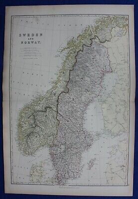
$11.82 Shipping Location: ILKLEY, United Kingdom SWEDEN& NORWAY. SCANDINAVIA, Blackie. original antique colour map 1882, SWEDEN& NORWAY. SCANDINAVIA, Blackie. original antique colour map 1882 ... moreSWEDEN and NORWAY Published 1882 by Blackie& Son. Glasgow, Edinburgh& London, in"Blackie's Comprehensive Atlas" An attractive good sized steel engraved antique map of Sweden and Norway with early colour printing. Fine condition. P rinted on heavy grade paper with centre fold as issued. Blank verso. Approx. 20" x 13.5" 500mm x 340mm) map area only with good margins beyond. Please see also close up image. A GENUINE ANTIQUE MAP GUARANTEED OVER 150 YEARS OLD FROM LINDISFARNE PRINTS FD313 We do not deal in reproductions. Facsimiles or copies of any kind. SHIPPING UK £2.50 via Royal Mail First Class Post Europe GBP £2.95 via Royal Mail Airmail Rest of the World GBP £3.95 via Royal Mail Airmail Two items are shipped for a single charge. Free shipping worldwide if three items or more purchased Closeups, Shipping Process, Two items are always combined for shipping and three items or more are shipped free of charge. Worldwide"Please see item description for postage costs" Payment Options, All major Credit and debit cards via PAYPAL. Personal cheque drawn on UK banks only. Postal Orders from UK post offices only. Bank transfer- please email for details. About Us, Lindisfarne Prints is a small family business specialising in genuine antique maps and prints at affordable prices.Established in 1995 and trading online since 2000. We pride ourselves on accurate descriptions, good communications, rapid service and fair prices. We are proud to maintain a 100% positive feedback rating which we hope reflects this.To avoid confusion, no item less than 100 years old is ever offered for sale. We do not deal in reproductions, facsimiles or modern copies of any kind. So please buy with confidence in the safe knowledge that authenticity is unfailingly assured. Return Policy, Customer satisfaction is paramount and any item not exactly
Buy It Now
$18.66 Shipping Location: CHICHESTER, United Kingdom The buildings have been engraved in extraordinary detail. Folds as given. Professionally cleaned and de-acidified. Publication: London in 1887. Author: ... moreFry. Herbert, Engraver: Sulman. T, / Ruffle.
Buy It Now
$18.66 Shipping Location: CHICHESTER, United Kingdom Publication: Les Plans et Profils de toutes les principals villes et lieux considerable de France. Par le Sieur Tassin Geographe ordinaire de la Majeste. ... moreA Paris, chez Martin Gobert, au Palais, en la Galerie des Prisonniers.
Buy It Now
$13.44 Shipping Location: GUILDFORD, United Kingdom EXCELLENT CONDITION. DATED 1903 (2ND).
Buy It Now
$3.00 Shipping Location: Freeport, United States
Buy It Now
$9.95 Shipping Condition: Used Location: LONDON, United Kingdom 'The Harbour of Leghorn'. Title of map:'The Harbour of Leghorn'. Antique engraved sketch map, 1885. DATE PRINTED: 1885. TYPE: Antique engraved sketch ... moremap. CONDITION: Good; suitable for framing. VERSO: There are images and/or text printed on the reverse side of the picture.
Buy It Now
$9.99 Shipping Location: Rosanna, Australia Dower is the heir to the more prominent London engraver and mapmaker John Crane Dower. He was elected to the Royal Geographical Society in 1854. This ... moreoriginal steel-plate engraved antique map by John Dower and published in the 1831 edition ofNew General Atlas.
Buy It Now
$14.93 Shipping Location: NORWICH, United Kingdom Original 1925 Antique London Map. Odd marks consistent with age.
Buy It Now
$11.52 Shipping Location: Mermaid Beach, Australia DATE PRINTED - 1634 so is over 380+ years old. This was printed from a copper engraved plate on handmade paper. This is not a modern reproduction. The ... morehand colouring is recent and has been professionally applied by us using the finest watercolours.
Buy It Now
$9.95 Shipping Condition: Unspecified Location: LONDON, United Kingdom PROVENANCE: "Norway, Sweden, and Denmark, with excursions to Iceland and Spitzbergen"; by Karl Baedeker, Published by Karl Baedeker, London: 10th Edition ... more[Norway, Sweden, and Denmark]. Antique colour map; Scale 1:2,400,000, 1912.
Buy It Now
$9.95 Shipping Condition: Unspecified Location: LONDON, United Kingdom Caption below picture:'Oban'. PROVENANCE: Ward Lock Red Guides. DATE PRINTED: 1930. CONDITION: Good; suitable for framing. The map you will receive is ... morein good condition but there may be minor variations in the condition from that shown in the image.
Buy It Now
$9.95 Shipping Condition: Used Location: LONDON, United Kingdom [West Woods, Bellby Wood, Collingham, Lady Wood, Compton, Spring Wood, Wattle Skye] (Map section # 32). Caption below picture:'[West Woods, Bellby Wood, ... moreCollingham, Lady Wood, Compton, Spring Wood, Wattle Skye]'.
Buy It Now
$12.00 Shipping Location: Roma, Italy Beautiful original engraving of XIX century. SIZE OF SHEET CM 26,5 X 17,5 APPROX. RARE FOR COLLECTOR. LITTLE DEFECTS ON WHITE MARGIN, IMAGE IN GOOD CONDITION.
Buy It Now
$9.95 Shipping Condition: Unspecified Location: LONDON, United Kingdom Villages, towns, mountain ranges and river valleys shown on the map include: Valser Rhine Rhein Furketlihorn Hinterrhein Rothorn Nufenen Piz Sorda Piz ... moreTerri Piz Aul Rothorn Kirchalphorn Splügen. Antique colour map; Scale 1:150.000, 1911.
Buy It Now
$4.50 Shipping Location: Slingerlands, United States This is an Army Map Service map (AMS V792) of Heceta Head (printed 6/1947) showing from Gwynn Knoll south to the Siuslaw River inlet. The map is 22" x ... more29" and at a scale of 1:50,000.
Buy It Now
$9.95 Shipping Condition: Unspecified Location: LONDON, United Kingdom PROVENANCE: "Rand Mc Nally's Unrivaled Atlas", Rand McNally, Chicago & New York, USA. 'Manitoba'. Title of map:'Manitoba'. Antique colour (color) atlas ... moremap, 1912. DATE PRINTED: 1912. CONDITION: Good; suitable for framing.
Buy It Now
$9.95 Shipping Condition: Unspecified Location: LONDON, United Kingdom 'Perpignan'. Title of map:'Perpignan'. DATE PRINTED: 1926. CONDITION: Good; suitable for framing. The map you will receive is in good condition but there ... moremay be minor variations in the condition from that shown in the image.
$17.82 Shipping Location: LEEDS, United Kingdom Vintage Ordnance Survey Map Lancaster & Kendal Superb Condition, Dispatched With Royal Mail.
Buy It Now
$9.95 Shipping Condition: Unspecified Location: LONDON, United Kingdom 'The Ampezzo Valley'. Title of map (not printed on the page):'The Ampezzo Valley'. Antique colour map; Scale 1:180,000, 1899. DATE PRINTED: 1899. The ... moreimage below shows an enlarged cross section from the centre of the map to show the level of printed detail.
Buy It Now
$9.95 Shipping Condition: Used Location: LONDON, United Kingdom 'Cirencester'. Caption below picture:'Cirencester'. This map was published within the 1832 Reform Act for the purposes of showing the proposed electoral ... moreborough constituency. Other places marked on the map include Siddington, Preston.

Buy It Now
$9.00 Shipping Location: Rockport, United States 1865 KOOS BAY Oregon COAST SURVEY& Tides ANTIQUE Map/ CHART ITEM DESCRIPTION HERE WE HAVE A LARGE ANTIQUE CHART/ MAP OF KOOS BAY. OREGON PRINTED IN ... more1865. IT IS FROM A TRIGONOMETRICAL SURVEY UNDER THE DIRECTION OF A.D. BACHE SUPERINTENDENT OF THE SURVEY OF THE COAST OF THE UNITED STATES. TRIANGULATION TOPOGRAPHY AND HYDROGRAPHY BY JAMES S. LAWSON SUB ASSIST. IT MEASURES 29” X 21.5” AND IS IN GOOD CONDITION FOR IT’S AGE WITH SOME TEARING ALONG THE FOLDS AND STAINING. CHECK OUT THE PHOTOS FOR MORE DETAILS ON THE CONDITION! WE WILL BE LISTING MANY OTHER MAPS AND ART SO BE SURE TO CHECK OUR OTHER LISTINGS! PLEASE BE SURE TO SEE ALL THE PHOTOS AFTER THE FINE PRINT THE FINE PRINT WE MUST BE ON YOUR FAVORITE SELLERS LIST! YOU WILL NOT BE DISAPPOINTED AS WE PRESENT WEEKLY A WIDE VARIETY OF UNIQUE ANTIQUE AND VINTAGE ITEMS. OVER 100 ITEMS A WEEK! WE USUALLY START OUR ITEMS AT $9.99! ALL OF OUR ITEMS COME FROM A CLEAN NON SMOKING HOME. WE RESPECTFULLY REQUEST THAT YOU CONSIDER THE COST OF SHIPPING BEFORE YOU PLACE YOUR BID& HAVE READ THE SHIPPING TERMS ESPECIALLY THE INTERNATIONAL SHIPPING TERMS. gsrx_vers_584(GS 6.8b5(584)
Buy It Now
$7.66 Shipping Location: Germany STOKE POGES / Berkshire: View to the church of 'Stocke Pogis. .. ', Steel engraving v. Payne n. Archer, around 1850, 10.8 x 16.2 Item number: 17908.
Buy It Now
$7.66 Shipping Location: Germany
Buy It Now
$11.82 Shipping Location: ILKLEY, United Kingdom Provenance: 'The Comprehensive Atlas & Geography of the World. ', London, Blackie & Son, 1882. Date: 1882. Railway lines are marked.
Buy It Now
$9.95 Shipping Condition: Unspecified Location: LONDON, United Kingdom 'Environs of Engelberg'. Title of map (not printed on the page):'Environs of Engelberg'. Antique colour map; Scale 1:150.000, 1897. DATE PRINTED: 1897. ... moreThe image below shows an enlarged cross section from the centre of the map to show the level of printed detail.
Buy It Now
$18.66 Shipping Location: CHICHESTER, United Kingdom Published for the Authors as the Act directs, 14th November 1778. … with the distances in Irish miles. Eleven Irish miles are equal to fourteen British.’’. ... moreOn each strip is a compass rose showing the direction of travel as well as the distance, in miles, from the start point.
Buy It Now
$9.95 Shipping Location: POOLE, United Kingdom FLINTSHIRE BY JOHN SELLER AND FRANCIS GROSE c1787 THIS MAP WAS FIRST PRODUCED BY JOHN SELLER FOR HIS WORK 'ANGLIA CONTRACTA' OF 1695. FRANCIS GROSE REPRODUCED ... moreIT WITH AN ADDED DESCRIPTION OF THE COUNTY FOR HIS 'ANTIQUITIES OF ENGLAND AND WALES' FROM 1777-1787. THIS COPPER ENGRAVED MAP IS IN EXCELLENT CONDITION WITH A GOOD CLEAR IMPRESSION & LATER HAND COLOUR. THIS IS A GENUINE ANTIQUE MAP AROUND 230 YEARS OLD THE MAP MEASURES APPROX 5.5 x 4.25 ins (14 x 11 cms) THE PAGE HAS A DESCRIPTIVE TEXT OF THE COUNTY ON BOTH SIDES. THE PAGE MEASURES APPROX 11.25 x 8 ins (28.5 x 21 cms).
Buy It Now
$7.00 Shipping Location: New Zealand 1828 map measures 28cms by 24cms,if buying more at buy it now prices please click ad to cart or continue shopping with this seller to get all combined ... morein one shipping cost,please dont pay each seperate as ebay charges more fees,any questions please ask,all items original vintage items
Buy It Now
$9.95 Shipping Condition: Unspecified Location: LONDON, United Kingdom 'Gloucester'. Title of map:'Gloucester'. DATE PRINTED: 1924. The image below shows an enlarged cross section from the centre of the map to show the level ... moreof printed detail CONDITION: Good; suitable for framing.
Buy It Now
$9.95 Shipping Condition: Unspecified Location: LONDON, United Kingdom Ski/winter sports resorts marked on the map include: Wengen Mürren. 'Environs of Grindelwald'. Title of map (not printed on the page):'Environs of Grindelwald'. ... moreAntique colour map; Scale 1:150,000, 1889.
Buy It Now
$9.95 Shipping Condition: Unspecified Location: LONDON, United Kingdom 'Brecknockshire'. Caption below picture:'Brecknockshire'. The map was published within the 1832 Reform Act for the purposes of showing the proposed electoral ... moreconstituencies within the county. Most counties were split into divisions (shown by the red line), and each division was further split into electoral wards (shown by the brown lines).

Buy It Now
$9.95 Shipping Condition: Unspecified Location: LONDON, United Kingdom Parliamentary Divisions showing county. Borough and division boundaries Colour vintage street atlas map. 1933 Title of map: Parliamentary Divisions showing ... morecounty. Borough and division boundaries' The image below shows an enlarged cross section from the centre of the map to show the level of printed detail: DATE PRINTED: 1933 IMAGE SIZE: Approx 31.5 x 44.0cm. 12.5 x 17.25 inches(Large) ARTIST/CARTOGRAPHER/ENGRAVER: The Geographia map company PROVENANCE: The Authentic map directory of London and suburbs" Third edition, edited by James Bain, FRGS, published by Geographia Ltd TYPE: Colour vintage street atlas map VERSO: There is another map printed on the reverse side of this map. The paper is thick. And the map on the reverse side does not show through the paper. CONDITION: Good; suitable for framing. However. Please note: This map was originally printed as two separate pages which have been professionally joined to form a single sheet. Please check the scan for any blemishes prior to making your purchase. Virtually all antiquarian maps and prints are subject to some normal aging due to use and time which is not obtrusive unless otherwise stated. I offer a no questions asked return policy- see below. AUTHENTICITY: This is an authentic historic print. Published at the date stated above. I do not offer reproductions. It is not a modern copy. The term'original' when applied to a print means that it was printed at the first or original date of publication; it does not imply that the item is unique. Print' means any image created by applying an inked block to paper or card under pressure by any method including wood engraving, steel engraving, copperplate, wood cut and lithography. REMARKS: FRANCE: Gravures et Cartes anciennes. DEUTSCHLAND: Alte Lankarten und Stadt ansichten. ITALIA: Stampe e Mappe antiche. ESPAÑA: Mapas antiquos y impresiones antiguas. E and OE. Force Majeure. English law shall apply. RETURNS POLICY: I offer a no questions returns policy. All I ask is that you pay return shipp
Buy It Now
$7.45 Shipping Location: PRENTON, United Kingdom
Buy It Now
$9.95 Shipping Condition: Unspecified Location: LONDON, United Kingdom 'Hounslow'. Title of map:'Hounslow'. DATE PRINTED: 1965. CONDITION: Good; suitable for framing. The map you will receive is in good condition but there ... moremay be minor variations in the condition from that shown in the image.
Buy It Now
$9.95 Shipping Condition: Unspecified Location: LONDON, United Kingdom Caption below picture:'Essex'. Antique colour atlas map, 1900. DATE PRINTED: 1900. CONDITION: Good; suitable for framing. The map you will receive is ... morein good condition but there may be minor variations in the condition from that shown in the image.
Buy It Now
$3.50 Shipping Location: Dover, United States Water Bodies: Cold River, Wild River. Year Published: 1972. The map in the photo is the actual map you will receive.
Buy It Now
$5.00 Shipping Location: Canada DATE OF ISSUE: 1909. ORIGIN OF THE MAP: "Northern France (.) - Handbook for Travellers", 5th edition, published by Karl Baedeker in Leipzig, Germany, ... moreDulau & Co., London, UK, Charles Scribner's Sons, New York, USA.
|
|
|
|