|
|
Order by: Available to: This site contains affiliate links for which I may be compensated
|
Buy It Now
Free Shipping Location: Netherlands Description: This plan originates from the famous city Atlas: 'Toneel der Steeden' published by Joan Blaeu 1649. Artists and Engravers: Anonymous.
Buy It Now
$16.45 Shipping Location: Santa Paula, United States This stunning vintage reproduction wall map features the New World as seen by Willem Blaeu in the 17th century. The map is beautifully framed and matted ... morewith gold foiling, making it a perfect addition to any collection of antique maps, atlases, and globes. Measuring 19x23 inches, this map is a true treasure for any lover of cartography and history.
Buy It Now
$121.30 Shipping Location: Newtown, United States The text is both Latin and English. Good pre-owned condition.
Buy It Now
$14.99 Shipping Location: Ivanhoe, Australia In 1672 a disastrous fire destroyed Blaeu\\\'s printing house in the Gravenstraat and a year afterwards Joan Blaeu died. Blaeu, Joan 1596-1673. It is ... morethe seat of Wołów County and Gmina Wołów. Date: - 1662.
Buy It Now
$33.96 Shipping Location: Seubersdorf, Germany Amsterdam, Pieter Mortier 1704. Magnificent copperplate engraving after a drawing by Joan Blaeu from 1704, from "Nouveau Theater d'Italie". -- Leaf mass ... moreapprox. 30x24cm. -- very well preserved. || || Splendid engraving after a drawing by Joan Blaeu. From "Nouveau Theater d'Italie" (1704). -- in good condition. || || This is an original! - No Copy! - No reprint! --Original! - No emphasis! - No copy! || || Joan Blaeu (1596 1673) was a Dutch cartographer, the son of renowned cartographer, atlas maker and publisher Willem Blaeu. He and his brother Cornelius took over the studio after the death of their father in 1638. He then became the official cartographer of the Dutch East India Company.Order number: 244809.
Buy It Now
$33.70 Shipping Location: Seubersdorf, Germany The Hague, Alberts 1726. Rare, magnificent copper engraving from Blaeu's city book of Piedmont-Savoy: "Novum Theatrum Pedemonti et Sabaudiae". From the ... more1726 edition. -- Sheet dimensions: approx. 63x57.5cm; Plate approx. 53x45cm. -- well preserved. || Beautiful rare engraving from the 1726 edition of Blaeu's work: "Novum Theatrum Pedemonti et Sabaudiae". -- in good condition. || Bella rara incisione tratta dall'edizione del 1726 del libro di Blaeu: "Novum Theatrum Pedemonti et Sabaudiae". -- in good condition.Order number: 202270.
Buy It Now
$30.00 Shipping Location: Paris VI, France Large and unusual antique copper engraved map of the province of Sedan and Donchery in eastern France,by Willem BLAEU, XVIIe Century. Then, the sons of ... moreWillem, Johan and Joan, joined him in the firm.
Buy It Now
$11.81 Shipping Location: ILKLEY, United Kingdom The title section is pasted into the relevant space, as published. Provenance: 'Le Theatre du Monde, ou Nouvel Atlas, Mis en Lumiere par Guillaum et Jean ... moreBlaeu. Title / Subject: Title page from a 1645 French edition of Blaeu's Npuvel Atlas, Vol.
Buy It Now
$33.70 Shipping Location: Seubersdorf, Germany Amsterdam, Pieter Mortier 1724. Magnificent copperplate engraving after a drawing by Joan Blaeu from 1704, from "Nouveau Theater d'Italie". -- Leaf mass ... moreapprox. 25x30cm. -- very well preserved. || || Splendid engraving after a drawing by Joan Blaeu. From "Nouveau Theater d'Italie" (1704). -- in good condition. || || This is an Original! - No Copy! - No reprint! --Original! - No reprint! - No copy! || || Joan Blaeu (1596 1673) was a Dutch cartographer, the son of renowned cartographer, atlas maker and publisher Willem Blaeu. He and his brother Cornelius took over the studio after the death of their father in 1638. He then became the official cartographer of the Dutch East India Company.Order number: 252986.
Buy It Now
$15.00 Shipping Location: Cyprus Mapmaker Willem Janszoon Blaeu (1571 – 21 October 1638), also abbreviated to Willem Jansz. Published by Johan and Willem Blaeu. Amsterdam, 1647. Blaeu ... morewas born at Uitgeest or Alkmaar as the son of a well-to-do herring salesman, he was destined to succeed his father in the trade, but his interests lay more in Mathematics and Astronomy.
Buy It Now
$16.23 Shipping Location: New York, United States This stunning circa 1640 map of the volcanic island of Ischia located in the Tyrrhenian Sea on the northern part of the Gulf of Naples depicts the mountainous ... moreisland in exquisite detail. A combination of a map and a Bird's-eye view, it covers the island as well the coast of nearby Naples.
Buy It Now
$30.00 Shipping Location: Paris VI, France Large, unusual and nice antique copper engraved map of Navarre in Spain,by Willem BLAEU (1571-1638), 17th century. Then, the sons of Willem, Johan and ... moreJoan, joined him in the firm. They produced their first atlas together in 1630 the "Atlas Appendix".
Buy It Now
$11.81 Shipping Location: ILKLEY, United Kingdom Title / Subject: 'Comitatus Nottinghamiensis, Nottingham shire'. The map is printed on good quality, hand-laid paper and is outline hand coloured. Date: ... morec.1645.
Buy It Now
$33.91 Shipping Location: Seubersdorf, Germany Amsterdam, Pieter Mortier 1704. Magnificent copperplate engraving after a drawing by Joan Blaeu from 1724, from "Nouveau Theater d'Italie". -- Leaf mass ... moreapprox. 63x52.5cm; Plate approx. 52x39cm. -- very well preserved. || || Splendid engraving after a drawing by Joan Blaeu from 1724. From "Nouveau Theater d'Italie". -- in good condition. || || This is an original! - No Copy! - No reprint! --Original! - No emphasis! - No copy! || || Joan Blaeu (1596 1673) was a Dutch cartographer, the son of renowned cartographer, atlas maker and publisher Willem Blaeu. He and his brother Cornelius took over the studio after the death of their father in 1638. He then became the official cartographer of the Dutch East India Company.Order number: 227546.
Buy It Now
Free Shipping Location: Netherlands Description: From the city Atlas: 'Toneel der Steeden' published by Joan Blaeu in 1649. Artists and Engravers: Joan Blaeu (23 September 1596 - 28 May ... more1673) was a Dutch cartographer. He was born in Alkmaar, the son of cartographer Willem Blaeu. In 1620 he became a doctor of law but he joined the work of his father. In 1635 they published the Atlas Novus (full title: Theatrum orbis terrarum, sive, Atlas novus) in two volumes. Joan and his brother Cornelius took over the studio after their father died in 1638. Joan became the official cartographer of the Dutch East India Company. Around 1649 Joan Blaeu published a collection of Dutch city maps named Tooneel der Steeden (Views of Cities).
Buy It Now
Free Shipping Location: Netherlands Description: Published in Amsterdam by J. Blaeu ca. 1650. Artists and Engravers: Joan Blaeu (23 September 1596 - 28 May 1673) was a Dutch cartographer. ... moreHe was born in Alkmaar, the son of cartographer Willem Blaeu. In 1620 he became a doctor of law but he joined the work of his father. In 1635 they published the Atlas Novus (full title: Theatrum orbis terrarum, sive, Atlas novus) in two volumes. Joan and his brother Cornelius took over the studio after their father died in 1638. Joan became the official cartographer of the Dutch East India Company. Around 1649 Joan Blaeu published a collection of Dutch city maps named Tooneel der Steeden (Views of Cities). In 1651 he was voted into the Amsterdam council.
Buy It Now
Free Shipping Location: Naples, United States A genuine antique map. Attractive hand color. Smoke Free house.
Buy It Now
$6.05 Shipping Location: Melrose, United States Vintage Hammond Map Print of Europe by Guilielmo Blaeuw 17th Century. Wonderful vintage reproduction of 17th century iconic atlas map by Guilielmo Blaeuw. ... moreAlso known as William Blaeu (1571-1638) who worked during the Dutch gold age of map making. This map is noted for its exquisite details and decorative features. Amazing depictions of cultural fashions along the border, intended to educate viewer of culture beyond the geographical nature of a map. Measures 24.5 X 16”. Some signs of age along the edges. Would be beautiful framed. Please see pictures for details. Please check out my other unique treasures.
Buy It Now
Free Shipping Location: United States Reipublicae Genuensis, Blaeu, map, anno 1635, old coloursCoppermap, edited by the Blaeu Family, circa 1635, german text on verso: "Genovesato serenissimae ... morereipublicae genuensis ducatus et dominii. nova descriptio". From Nice, Monaco to Genova and to Massa. Old colours, size of the leaf: 50x60 cm..
Buy It Now
$35.00 Shipping Location: Canaan, United States There is overall darkening and a large stain.
Buy It Now
$30.00 Shipping Location: Paris VI, France Large and nice antique copper engraved map of Cyprus,by Willem BLAEU (1571-1638), 17th century. Then, the sons of Willem, Johan and Joan, joined him in ... morethe firm. They produced their first atlas together in 1630 the "Atlas Appendix".
Buy It Now
$30.00 Shipping Location: Paris VI, France Then, the sons of Willem, Johan and Joan, joined him in the firm. They produced their first atlas together in 1630 the "Atlas Appendix". Five years later, ... moretheir produced their "Atlas Novus", edited in 4 languages.
Buy It Now
$30.00 Shipping Location: Paris VI, France Large, unusual and nice antique copper engraved map of Majorca, Minorca and Ibiza,by Willem BLAEU (1571-1638), 17th century. Then, the sons of Willem, ... moreJohan and Joan, joined him in the firm. They produced their first atlas together in 1630 the "Atlas Appendix".
Buy It Now
Free Shipping Location: Naples, United States A genuine antique map. Copper engraving printed on paper. Attractive hand color.
Buy It Now
$51.51 Shipping Location: LEYBURN, United Kingdom Original engraved map from Joan Blaeu’s Atlas Major of 1662-1665, engraved from the late 16th century surveys of Scotland by Rev. Timothy Pont. Joan Blaeu ... more(1599 – 1673), Dutch map maker, engraver and printer.
Buy It Now
$25.00 Shipping Location: Central Valley, United States Granata Et Murcia Regna. Map Maker: Willem Janszoon Blaeu.
$17.12 Shipping Location: LEEDS, United Kingdom This magnificent vintage reproduction of the Wallia Principatus Vulgo Wales map by Johannes Blaeu circa 1650 is a must-have for any map collector or Wales ... moreenthusiast. This map showcases the beautiful Welsh landscape with its stunning mountains, valleys, and rivers, as well as its important towns and cities.The map is a high-quality reproduction of the original and measures [insert dimensions]. It is perfect for framing and displaying in your home, office, or study. The map has been carefully reproduced to ensure that all details are captured accurately, making it an excellent addition to any collection.
Buy It Now
$23.00 Shipping Location: SHREWSBURY, United Kingdom INSULAE ALBION et HIBERNIA. JOHANNES BLAEU. A fine Blaeu copper engraved Ptolemaic map of The British Isles with original hand colouring. The original ... morecentral fold has been reinforced verso. 17.5" x 15" (440mm x 380mm) map area only, with good margins beyond.
Buy It Now
$35.56 Shipping Location: Saratoga Springs, United States BLAEU NOVA VIRGINIA TABVLA VIRGINIA MAP WATERMARK. 20x12 7/8 IMAGE 12 1/2 X 9 3/4 Shipped with USPS Ground Advantage. VIRGINIA *NOT 1600's*
Buy It Now
Free Shipping Location: Netherlands Description: This view originates from the famous city Atlas: 'Toneel der Steeden' published by Joan Blaeu 1649. Artists and Engravers: Made by 'Joan ... moreBlaeu' after an anonymous artist. Joan Blaeu (23 September 1596 - 28 May 1673) was a Dutch cartographer. He was born in Alkmaar, the son of cartographer Willem Blaeu. In 1620 he became a doctor of law but he joined the work of his father. In 1635 they published the Atlas Novus (full title: Theatrum orbis terrarum, sive, Atlas novus) in two volumes. Joan and his brother Cornelius took over the studio after their father died in 1638. Joan became the official cartographer of the Dutch East India Company.
Buy It Now
$14.99 Shipping Location: Ivanhoe, Australia After the Romans conquered Gaul, they too made the city the capital of the Civitas Morinorum district. In 1672 a disastrous fire destroyed Blaeu\\\'s ... moreprinting house in the Gravenstraat and a year afterwards Joan Blaeu died.
Buy It Now
$14.99 Shipping Location: Ivanhoe, Australia This original beautifully hand coloured antique map of the English County of Berkshire by Joan Blaeu was published in the 1662 edition ofAtlas Major. ... more(Ref: Tooley; M&B). In 1672 a disastrous fire destroyed Blaeu\'s printing house in the Gravenstraat and a year afterwards Joan Blaeu died.
Buy It Now
$7.96 Shipping Location: Saint Petersburg, United States DEVONIA vulgo DEVON-SHIRE by JOAN BLAEU Published Amsterdam circa 1645. Enhanced with attractive hand coloring, professionally applied to the original ... morepattern. In good antique condition considering age.
Buy It Now
$25.00 Shipping Location: Monroe, United States Map is in very good condition and as pictured. Very sharp image. A central vertical crease where previously folded. Our apology for quality of our pictures ... morebut was very hard to make clear pictures of this map because of glass cover.
Buy It Now
$33.70 Shipping Location: Seubersdorf, Germany Amsterdam approx. 1640. Large old colored copper engraving map from approx. 1640. -- With Latin text on the back. -- Sheet dimensions: approx. 49.5x59cm. ... more-- well preserved. || Large old colored map from c. 1640. With Latin text on verso. -- in good condition. || This is an original! - No emphasis! - No copy! -- This is an original! - No copy! - No reprint!Tags: AtlasOrder number: 228137.
Buy It Now
Free Shipping Location: Oceanside, United States This is a colored version. Overall: 24 x 29 1/4 in. Sight: 17 x 22 1/4 in.
Buy It Now
$30.00 Shipping Location: Paris VI, France Large and nice antique copper engraved map of Provence (France),by Willem BLAEU (1571-1638), from a map of Joanne Bampario. Then, the sons of Willem, ... moreJohan and Joan, joined him in the firm. They produced their first atlas together in 1630 the "Atlas Appendix".
Buy It Now
$33.96 Shipping Location: Seubersdorf, Germany Amsterdam, Pieter Mortier 1704. Magnificent copperplate engraving after a drawing by Joan Blaeu from 1704, from "Nouveau Theater d'Italie". -- Leaf mass ... moreapprox. 28x31cm. -- with a small margin on the lower outer edge, otherwise very well preserved. || || Splendid engraving after a drawing by Joan Blaeu. From "Nouveau Theater d'Italie" (1704). -- narrowly cut on the lower outer margin, otherwise in good condition. || || This is an original! - No Copy! - No reprint! --Original! - No emphasis! - No copy! || || Joan Blaeu (1596 1673) was a Dutch cartographer, the son of renowned cartographer, atlas maker and publisher Willem Blaeu. He and his brother Cornelius took over the studio after the death of their father in 1638. He then became the official cartographer of the Dutch East India Compan.
Buy It Now
Free Shipping Location: Warwick, United States [Blaeu family.]. Bonne Ville, map plate from the Blaeu townbook, n.p. [Amsterdam]: Johannes de Ram, no date [1675-1725].
Buy It Now
Free Shipping Location: Netherlands Description: Source unknown, to be determined. Artists and Engravers: Made by an anonymous engraver after 'Joan Blaeu'. Joan Blaeu (1596-1673) was a Dutch ... morecartographer. He was born in Alkmaar, the son of cartographer Willem Blaeu. In 1620 he became a doctor of law but he joined the work of his father. In 1635 they published the Atlas Novus in two volumes. Joan and his brother Cornelius took over the studio after their father died in 1638. Joan became the official cartographer of the Dutch East India Company. Around 1649 Joan Blaeu published a collection of Dutch city maps named Tooneel der Steeden (Views of Cities). In 1662 he reissued the atlas with 11 volumes, and one for oceans. It was also known as Atlas Maior.
Buy It Now
$33.71 Shipping Location: Seubersdorf, Germany Amsterdam, 1649. Leaf mass approx. 48.5 x 59 cm - plate approx. 38 x 50.5 cm - Original hand-colored copperplate map from 1649. With German text on the ... moreback. - From Blaeu's "Novus Atlas, This is a description of the world with beautiful new detailed country plates engraved in copper and presented". - in the lower outer edge with a backed edge tear, otherwise in good condition -- Rare hand-colored engraved map from the German edition of Blaeus Novus Atlas from 1649. With German text on verso. -- with deposited marginal tear on the lower outer margin, otherwise in good condition. || This is an original! - No emphasis! - No copy! -- This is an original! - No copy! - No reprint!Order number: 222723.
Buy It Now
$6.95 Shipping Location: Dover, United States Issued Amsterdam, 1612 by Blaeu for Guicciardini. Deys' Guicciardini Illustratus. Lier 2.2-11. Beautiful, detailed early 17th century copper engraved ... morecity plan. If this were an antique coin, it would have a nice surface.
$30.00 Shipping Location: Switzerland The Trinity is illustrated in the upper left corner. 59,5 cm x 50,5 cm. Very good condition.
Buy It Now
$33.70 Shipping Location: Seubersdorf, Germany The Hague, Alberts 1726. Rare, magnificent copper engraving from Blaeu's city book of Piedmont-Savoy: "Novum Theatrum Pedemonti et Sabaudiae". From the ... more1726 edition. -- Sheet dimensions: approx. 63x57.5cm; Plate approx. 62x46cm. -- well preserved. || Beautiful rare engraving from the 1726 edition of Blaeu's work: "Novum Theatrum Pedemonti et Sabaudiae". -- in good condition. || Bella rara incisione tratta dall'edizione del 1726 del libro di Blaeu: "Novum Theatrum Pedemonti et Sabaudiae". -- in good condition.Order number: 202362.
Buy It Now
$22.95 Shipping Location: Rockville, United States Copper engraving printed on paper. Author: Blaeu, W. The map based on a previous chart prepared by Pieter Codde, a sea captain from Enkhuizen in Holland, ... moreshows the coast from Dunkirk to Gravelines and beyond with inset at lower right corner of Calais (partially disrupted due to framing).
Buy It Now
$20.20 Shipping Location: Eau Claire, United States
Buy It Now
$30.00 Shipping Location: Paris VI, France Large, unusual and nice antique copper engraved map of Andalucia in Spain,by Willem BLAEU (1571-1638), 17th century. Then, the sons of Willem, Johan and ... moreJoan, joined him in the firm. They produced their first atlas together in 1630 the "Atlas Appendix".
Buy It Now
$33.57 Shipping Condition: Unspecified Location: LONDON, United Kingdom Westmoria Comitatus; Anglice Westmorland [Westmoreland]. Caption below picture:'Westmoria Comitatus; Anglice Westmorland [Westmoreland]'. PROVENANCE: ... more"Le Th��tre du Monde ou Nouvel Atlas",�Amsterdam, Joan Blaeu, 1645.
Buy It Now
$9.95 Shipping Location: POOLE, United Kingdom SUFFOLCIA Vernacule SUFFOLKE BY JOHANNES BLAEU c1654 A GENUINE ORIGINAL COPPER ENGRAVED MAP WITH HAND COLOUR AND LATIN TEXT ON THE VERSO. THIS MAP IS ... moreIN GOOD CONDITION WITH JUST A LITTLE BROWNING TO THE MARGINS. THERE IS A CENTREFOLD CREASE AS PUBLISHED. THE MAP MEASURES APPROX 19.5 x 15 ins (49 x 38 cms) PLUS GOOD MARGINS. JOHANNES BLAEU (1596-1673) DUTCH MAPMAKER WHOSE CROWNING ACHIEVEMENT WAS THE PUBLICATION OF THE CARTOGRAPHICAL MASTERPIECE "ATLAS MAJOR" THE MOST EXPENSIVE PUBLICATION OF THE 17th CENTURY.
Buy It Now
$21.65 Shipping Location: Benicia, United States Antique hand colored map by Willem Blaeu of Walachia, Serbia, Bulgaria, Romania. The map is a period piece from the 17th century on laid paper with plate ... moremark. Map is intact and ready to be framed. Good condition overall for age with toning, foxing, surface wear, separations/small losses at edges, etc. Please see all photos for condition.Ships well packed and fully insured
Buy It Now
$30.00 Shipping Location: Paris VI, France Then, the sons of Willem, Johan and Joan, joined him in the firm. They produced their first atlas together in 1630 the "Atlas Appendix". Five years later, ... moretheir produced their "Atlas Novus", edited in 4 languages.
Buy It Now
$33.40 Shipping Location: United Kingdom Map of Wales by Joan Blaeu (1645 - 1665).
Buy It Now
$79.07 Shipping Location: Jacksonville, United States Circa 1649 J. Blaeu antique map of Harderwijk Netherlands. A beautiful and colorful map from the Novum Ac Magnum Theatrum Urbium Belgicae Liberae Ac Foederatae. ... moreAmsterdam, first edition published in 1649.
$114.71 Shipping Location: Santa Maria, United States Stored in closet after being framed in 1950. AFRIQUE beautifully reports total population of the continent of AFRIQUE as 18,000 people.
Buy It Now
$114.39 Shipping Location: NEWPORT, United Kingdom JOHANNES BLAEU. PUBLISHED CIRCA 1650. ORIGINAL 17TH CENTURY MAP OF. OVERALL A LOVELY EXAMPLE OF AN EARLY MAP.
Buy It Now
$80.95 Shipping Location: Battle Ground, United States
Buy It Now
$20.07 Shipping Location: GLASGOW, United Kingdom Facsimile reprint from Blaeu’s Atlas of Scotland, 1654.
Buy It Now
$2.50 Shipping Location: Los Angeles, United States The map is embellished with compass roses to guide the horse and rider as well as mileage markers, churches, windmills and buildings of note. Emanuel ... moreBowen (1694 – 8 May 1767) was aWelsh map engraver, who achieved the unique distinction of becoming Royal Mapmaker to both toKing George II of Great Britain andLouis XV of France.
Buy It Now
$6.95 Shipping Location: Cyprus Title: Austria Archiducatus auctore Wolfgango Lazio. Publisher Willem Janszoon Blaeu (1571 – 21 October 1638), also abbreviated to Willem Jansz. Blaeu ... morewas born at Uitgeest or Alkmaar as the son of a well-to-do herring salesman, he was destined to succeed his father in the trade, but his interests lay more in Mathematics and Astronomy.
Buy It Now
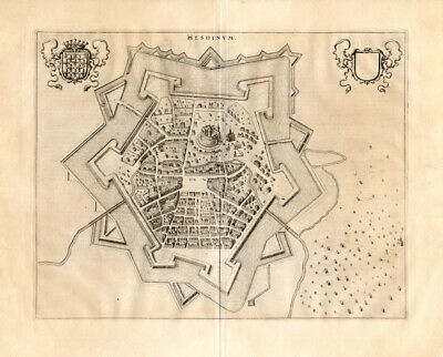
Free Shipping Location: Netherlands ABOUT US VISIT OUR STORE SALES SPECIALS Antique Map-FRANCE-BELGIUM-HESDIN-Blaeu-1650 Description: Published in Amsterdam by J. Blaeu ca. 1650. Artists ... moreand Engravers: Joan Blaeu(23 September 1596- 28 May 1673) was a Dutch cartographer. He was born in Alkmaar. The son of cartographer Willem Blaeu. In 1620 he became a doctor of law but he joined the work of his father. In 1635 they published the Atlas Novus(full title: Theatrum orbis terrarum, sive, Atlas novus) in two volumes. Joan and his brother Cornelius took over the studio after their father died in 1638. Joan became the official cartographer of the Dutch East India Company. Around 1649 Joan Blaeu published a collection of Dutch city maps named Tooneel der Steeden(Views of Cities) In 1651 he was voted into the Amsterdam council. In 1654 Joan published the first atlas of Scotland, devised by Timothy Pont. In 1662 he reissued the atlas with 11 volumes, and one for oceans. It was also known as Atlas Maior. A cosmology was planned as their next project, but a fire destroyed the studio completely in 1672. Joan Blaeu died in Amsterdam the following year. Subject: Plate: Hesdinum' Groundplan of Hesdin. Copper engraved bird's eye view of Hesdin in Belgium. From Blaeu's townbook of the southern Netherlands. First published in 1649. Blaeu composed his townbooks towards the end of the conflict with Spain and consequently the atlas became linked with the Dutch struggle for independence, proudly showing cities and stategic places. The town of Hesdin was forceably moved in the mid 16th century to its present site down in the Canche Valley by order of the Spanish Emperor Charles V. The old Hesdin was located in the hills and had been a dangerous French stronghold in the border wars between France and Spanish Flanders. Condition: Excellent; general age related toning. Size(in cm) The overall size is ca. 63 x 52 cm. The image size is ca. 50 x 39 cm. Size(in inch) The overall size is ca. 24.8 x 20.5 inch. The image size is ca. 19.7 x 15.4 inch. Medium: Copperplat
|
|
|
|
ANTIQUE MAP by Willem Janszoon Blaeu Navarra Regnum SPAIN
ALMOST 400 YEARS OLD MAP! Willem Janszoon Blaeu's: NAVARRA REGNVUM" maps of Spain. North is oriented to the right on this supremely decorative map of Navarre. The map. Roughly centered on Pamplona, describes the Ebro River valley on the left, and extends into France including the coastal city of Bayonne. French text on verso. DATE: 1630's. MEDIUM: copperplate. Hand colored CONDITION: strong paper. Wide margins, folding next to center fold, there is some foxing, mostly confined to the margins(see pictures for details) SIZE: 21 3/4 X 25 1/2 inches. Plate size: 16 1/4 X 19 3/4.
|
|
|
BLAEU, W H/C FOLIO MAP OF MOROCCO 1635 FEZZE ET MAROCCHI AFRICAE
Title: FEZZAE ET MAROCCHI REGNA AFRICAE CELEBERIMMA Cartographer: Willem Blaeu 19.5" x 15" First Edition'Theatrum Orbis Terrarum' Amsterdam 1635 Willem Janszoon Blaeu Was born in Alkmaar in 1571 and trained in astronomy and the sciences by Tycho Brahe. The celebrated Dansish astromer, and founded a business in Amsterdam in 1599 as a globe and instrument maker. It was not long before the business expanded, publishing maps, geographical works and books of sea charts as well as constructing globes. In 1635, the first two volumes of his planned world atlas, Atlas Novus or the Theatrum Orbis Terrarum were published. In 1636, Blaeu died and the business passed into the hands of his sons, Joan and Cornelis, who continued and expanded their father's ambitious plans. A wonderful. Copperplate map of Morocco and West North Africa ... moreby one of the great cartographers of the Mid-Seventeenth Century. Original coloration, all margins intact. With minor foxing and toning, as is typical of maps of this period. We are North America's specialists in the original First Edition lithographs of David Roberts. Over 500 lithographs of the renowned Scottish artist are in our inventory. WE DO NOT SELL REPRODUCTIONS OR RESTRIKES OF ANY KIND. Please excuse the lack of clarity and dark contrast in the photographic images. I will be happy to forward additional jpgs at your request. Prices are in U.S. dollars and do not reflect postage. Packing and insurance. Payment is expected within seven(7) days at the close of the auction. Additional insurance may be designated at the time of purchase. Any item may be returned within seven(7) days of receipt for a full refund(less shipping and insurance) We accept VISA, MasterCard and American Express, or PAYPAL. A special flat parcel rate of $20.00(which includes special packing and insurance) will be applicable for domestic shipping( Canada $30.00) International orders require additional postage and insurance(about $50.00) I will combine shipping for multiple pieces. Please examine
|
|
|
Map of Hantonia Hampshire Coat of Arms Great Britian England Blaeu Reprint 1645
18" x 22" Map is in excellent condition. It will be mailed rolled up& placed in a tube. This is a reprint of Joan Blaeu from 1645. U.S. S&H is $8.00 and International is $18.00. I accept paypal only. Any questions. Please ask before bidding. Thanks for looking.
|
|
|
WALES, CARDIGANSHIRE, J.BLAEU Original antique map c1645
CERETICA; sive CARDIGANENSIS Comitatus Anglis CARDIGANSHIRE by JOAN BLAEU Published Amsterdam circa 1645 A fine original Blaeu copper engraved map of Cardiganshire. Wales with the title displayed in a decorative cartouche featuring a hunter, wildfowl, beaver and fish(see close up scan below) A scale of miles is also featured in a separate cartouche surmounted by putti and several coats of arms add to the appeal. The sea area is decorated with sailing ships. Presented in its original uncoloured form but can be supplied professionally hand coloured at an extra cost if preferred- email for details. A crisp. Dark impression in fine condition, free of repairs or restoration. Centre fold as issued. The heavy grade hand laid paper remains robust and stable. Approx. 20" x 15" 510mm x 380mm) map area only. With good margins beyond. Please ... morescroll right down for further images. Willem Janzoon Blaeu(1571-1638) founded the Bleau publishing company which dominated the mapmaking industry of 17th century Netherlands. His sons Joan(Johannes) and Cornelius continued the family business after Willem's death in 1638. Their greatest achievement was perhaps the famous atlas"Theatrum Orbis Terrarum Sive. Atlas Novus" which eventually ran to 12 volumes and was published in several languages from 1635- 1662. The print shop and warehouse was destroyed by fire in 1672 and Willem's last son died the following year. A GENUINE ANTIQUE MAP GUARANTEED OVER 300 YEARS OLD FROM LINDISFARNE PRINTS We do not deal in reproductions. Facsimiles or modern copies of any kind. INSURED SHIPPING UK £7.95 via Royal Mail Special Delivery. EUROPE £9.95 via Royal Mail International Signed For Airmail USA and the rest of the world £10.95 via Royal Mail International Signed For Airmail. THANKS FOR YOUR INTEREST! Why not browse our ebaystore? Be sure to add me to your! Check out my! D912. Powered by
|
|
|
Original antique map of Denbigh & Flint by Joan Blaeu, 1646-64
An original antique map of DENBIGHSHIRE AND FLINTSHIRE(Denbighensis Comitatus et Comitatus Flintensis) by Joan Blaeu published in Amsterdam in either the Atlas Novus or Atlas Maior. 1646-64. The map is mounted but unframed(490x380mm) with original hand-colouring, and Dutch text verso. This is an excellent example in first class condition. Check out my! RcmdId ViewItemDescV4,RlogId p4%60bo7%60jtb9%3Fuk.rp*7725b%60%3E-13d472fd319-0xf4-
|
|
|
227 antique map 17th Century atlas Van der Hagen BLAEU Hooghe VISSCHER Peeters 1
Coins of India Reference Library This DVD is part of our Historic Map and Atlas Collection. We have dozens of Atlas maps on DVD ranging from the 1500s to the 1900s covering many areas and topics. Please Check our Ebay Store for what's available. VERY LARGE HIGH RESOLUTION MAP COLLECTION ON DVD! please see full table of contents and sample illustrations below) Title of this Atlas: The Atlas Van der Hagen(Volumes 1 and 2) This is disk 1 of a two volume set This relatively unknown atlas consists of four leather-bound volumes. Each about 100 pages. They were collected at the end of the seventeenth century, probably by the Amsterdam merchant Dirk van der Hagen. The Atlas contains about 450 maps and prints from all parts of the world. They differ in size and are brilliantly coloured The Atlas Van der Hagen is an important cultural sources for ... morethe life and art of the seventeenth and eighteenth centuries the term'atlas' means more than a book with maps. It contains maps and topographic images along with portraits. Prints of cityscapes, maps, emblems and mythological scenes. The Atlas Van der Hagen(circa 1690) has illustrations and prints from the entire world. Includes works by such famous cartographers and artists as Johannes van Keulen. Joan and Cornelis Blaeu, Romeyn de Hooghe, Nicolaas Visscher, Jacobus Peeters, Johannes Janssonius, Frederik de Wit and others. Considered to be some of the finest maps ever published. Features of this DVD This auction is for a DVD of the maps listed in electronic form. NOT the maps themselves. These maps are VERY high resolution and can be printed at FULL SCALE or LARGER for framing and display. The results are very high quality and convincing The files are in PDF format for easy of viewing and printing. Maps can be viewed and many scales and zoom features are available as with any PDF file. Ad and DVD copyright 2011 Euriskodata All Rights Reserved Powered by The free listing tool. List your items fast and easy and manage your active items. lm3vhp.RcmdId ViewItemDescV4,Rlog
|
|
|
NOTTINGHAMSHIRE, JOAN BLAEU Original antique map c1645
Comitatus NOTTINGHAMIENSIS NOTTINGHAMSHIRE by JOAN BLAEU Published Amsterdam circa 1645 A fine original Blaeu copper engraved county map of Nottinghamshire. England with the title displayed in a decorative cartouche featuring farm workers harvesting corn(see close up scan below) A scale of miles is also featured in a separate cartouche surmounted by putti. Numerous coats of arms add to the appeal. Presented in its original uncoloured state, but can be supplied professionally hand coloured at an extra cost if preferred- email for details. A crisp. Dark impression in fine condition, free of repairs or restoration. Centre fold as issued. The heavy grade hand laid paper remains robust and stable. Approx. 20" x 15" 510mm x 380mm) map area only. With good margins beyond. Please scroll right down for further images. Willem Janzoon Blaeu(1571-1638) ... morefounded the Bleau publishing company which dominated the mapmaking industry of 17th century Netherlands. His sons Joan(Johannes) and Cornelius continued the family business after Willem's death in 1638. Their greatest achievement was perhaps the famous atlas"Theatrum Orbis Terrarum Sive. Atlas Novus" which eventually ran to 12 volumes and was published in several languages from 1635- 1662. The print shop and warehouse was destroyed by fire in 1672 and Willem's last son died the following year. A GENUINE ANTIQUE MAP GUARANTEED OVER 300 YEARS OLD FROM LINDISFARNE PRINTS We do not deal in reproductions. Facsimiles or modern copies of any kind. INSURED SHIPPING UK £7.95 via Royal Mail Special Delivery. EUROPE £9.95 via Royal Mail International Signed For Airmail USA and the rest of the world £10.95 via Royal Mail International Signed For Airmail. THANKS FOR YOUR INTEREST! Why not browse our ebaystore? Be sure to add me to your! Check out my! D912. Powered by
|
|
|
RUTLAND, RUTLANDSHIRE, BLAEU Original antique map c1645
RUTLAND. RUTLANDSHIRE, BLAEU Original antique map c1645, RUTLAND. RUTLANDSHIRE, BLAEU Original antique map c1645 RUTLANDIA Comitatus RUTLAND SHIRE by JOHANNES BLAEU Published Amsterdam circa 1645 A fine original Blaeu copper engraved map of the county of Rutland. The title is displayed in a decorative cartouche with a vignette background scene of shepherds. Sheep, cattle, fruit and putti. A scale of miles is displayed in a separate cartouche with a putto, surveyor, dividers and armillary sphere. Royal crests and coats of arms of the noblemen of Rutland add to the visual appeal. Presented in its original uncoloured form but can be supplied with attractive hand colouring. Professionally applied to the original pattern. email for details) Scarce blank verso edition therefore devoid of the bleedthrough of text which is often seen. A crisp. Dark ... moreimpression in fine condition. Free of repairs or restoration. Faint original centre fold, with an associated vertical crease. The heavy grade hand laid paper remains robust and stable. Approx. 20" x 15" 510mm x 380mm) map area only. With good margins beyond. Please scroll right down for further images. Willem Janzoon Blaeu(1571-1638) founded the Blaeu publishing company which dominated the mapmaking industry of 17th century Netherlands. His sons Joan(Johannes) and Cornelius continued the family business after Willem's death in 1638. Their greatest achievement was perhaps the famous atlas"Theatrum Orbis Terrarum Sive. Atlas Novus" which eventually ran to 12 volumes and was published in several languages from 1635- 1662. The print shop and warehouse was destroyed by fire in 1672 and Willem's last son died the following year. A GENUINE ANTIQUE MAP GUARANTEED OVER 300 YEARS OLD FROM LINDISFARNE PRINTS We do not deal in reproductions. Facsimiles or modern copies of any kind. INSURED SHIPPING UK £7.95 via Royal Mail Special Delivery. EUROPE £9.95 via Royal Mail International Signed For Airmail USA and the rest of the world £10.95 via Royal
|
|
|
LEICESTERSHIRE, BLAEU Original antique map c1645
LEICESTERSHIRE. BLAEU Original antique map c1645, LEICESTERSHIRE. BLAEU Original antique map c1645 LEICESTRENSIS Comitatus LEICESTERSHIRE by JOHANNES BLAEU Published Amsterdam circa 1645 A fine original Blaeu copper engraved map of the county of Leicestershire. The title is displayed in a decorative cartouche and a scale of miles is displayed in a separate cartouche with numerous putti gathering stars from the ground. Royal crests and a pyramid of coats of arms of the noblemen of Leicestershire add to the visual appeal. Presented in its original uncoloured form but can be supplied with attractive hand colouring. Professionally applied to the original pattern. email for details) Scarce blank verso edition therefore devoid of the bleedthrough of text which is often seen. A crisp. Dark impression in fine condition. Free of repairs or restoration. ... moreFaint original centre fold, with an associated vertical crease. The heavy grade hand laid paper remains robust and stable. Approx. 20" x 15" 510mm x 380mm) map area only. With good margins beyond. Please scroll right down for further images. Willem Janzoon Blaeu(1571-1638) founded the Blaeu publishing company which dominated the mapmaking industry of 17th century Netherlands. His sons Joan(Johannes) and Cornelius continued the family business after Willem's death in 1638. Their greatest achievement was perhaps the famous atlas"Theatrum Orbis Terrarum Sive. Atlas Novus" which eventually ran to 12 volumes and was published in several languages from 1635- 1662. The print shop and warehouse was destroyed by fire in 1672 and Willem's last son died the following year. A GENUINE ANTIQUE MAP GUARANTEED OVER 300 YEARS OLD FROM LINDISFARNE PRINTS We do not deal in reproductions. Facsimiles or modern copies of any kind. INSURED SHIPPING UK £7.95 via Royal Mail Special Delivery. EUROPE £9.95 via Royal Mail International Signed For Airmail USA and the rest of the world £10.95 via Royal Mail International Signed For Airmail.
|
|
|
SOMERSET, JOHANNES BLAEU Original antique hand coloured map c1645
SOMERSET. JOHANNES BLAEU Original antique hand coloured map c1645, SOMERSET. JOHANNES BLAEU Original antique hand coloured map c1645 SOMERSETENSIS Comitatus Vernacule SOMERSET SHIRE by JOHANNES BLAEU Published Amsterdam circa 1645 A fine original Blaeu copper engraved county map of Somerset. England with the title displayed in a decorative cartouche. Several coats of arms of the noblemen of Somerset together with sailing ships in the sea, all add to the visual appeal. A scale of miles is displayed in a separate cartouche featuring sheep. Enhanced with attractive later hand colour. Professionally applied to the original pattern. Scarce blank verso edition therefore devoid of the bleedthrough of text which is often seen. An excellent example of an elegant and desirable map, about as good as they come. A crisp. Dark impression in fine condition. ... moreFree of repairs or restoration. The original centre fold is faint and unobtrusive and the heavy grade hand laid paper remains robust and stable. Approx. 20" x 15" 510mm x 380mm) map area only. With good margins beyond. Please scroll right down for further images. Willem Janzoon Blaeu(1571-1638) founded the Blaeu publishing company which dominated the mapmaking industry of 17th century Netherlands. His sons Joan(Johannes) and Cornelius continued the family business after Willem's death in 1638. Their greatest achievement was perhaps the famous atlas"Theatrum Orbis Terrarum Sive. Atlas Novus" which eventually ran to 12 volumes and was published in several languages from 1635- 1662. The print shop and warehouse was destroyed by fire in 1672 and Willem's last son died the following year. A GENUINE ANTIQUE MAP GUARANTEED OVER 300 YEARS OLD FROM LINDISFARNE PRINTS We do not deal in reproductions. Facsimiles or modern copies of any kind. INSURED SHIPPING UK £7.95 via Royal Mail Special Delivery. EUROPE £9.95 via Royal Mail International Signed For Airmail USA and the rest of the world £10.95 via Royal Mail International Signed For Airmail.
|
|
|
1715 c ATLAS BLAEU MAUSOLEUM AUGUSTUS ROME ITALY CAMPUS MARTIUS ACTIUM QUIRINAL
Original and rare coloured copper engraving by Willem& Joan Blaeu printed in 1715 c entitled" Mausoleum Augusti" Size 15.7" x 10.6" cm 40 x 27 SHIPPING COSTS TO EUROPE. AMERICA, ASIA, AFRICA, OCEANIA: registered mail US$ 13.00- each additional item free of charge
|
|
|
Sluis Holland antique plan Joan Blaeu/Sanderus 1725
. Sluis Holland antique plan Joan Blaeu/Sanderus 1725 Title: L’ECLUSE EN FLANDRE See also: Novum Ac Magnum Theatrum Urbium Belgicae Liberae Ac Foederatae. Amsterdam. J. Blaeu, 1649. Koeman, Bl62) ORIGINAL ANTIQUE COPPER PLATE ENGRAVING HAND COLORED. Engraving is Guaranteed authentic. A Certificate of Authenticity will be on request forwarded for each individual map or print. Size: Leaf app. 44 x 27 cm. 17.5 x 10.5 inches. Map app. 31.5 x 23.5 cm. 12.5 x 9.25 inches. Condition: Very good. Strong engraving. All maps and prints are genuine. Authentic, published at the date stated in this listing! For better quality pictures please go to our web site: WWW.MAPANDMAPS.COM I offer a no questions returns policy. All maps and prints are genuine. Authentic, published at the date stated above. Worldwide shipping by signed registered mail or Global ... moreExpress courier. Shipping fee is per combined shipment. Including handling and insurance. Free shipping worldwide if three items or more purchased. . .
|
|
|
HUNTINGDONSHIRE, JOAN BLAEU Original antique map c1645
HUNTINGDONENSIS Comitatus HUNTINGDONSHIRE by JOAN BLAEU Published Amsterdam circa 1645 A fine original Blaeu copper engraved county map of Huntingdonhire. England with the title displayed in a decorative cartouche featuring huntsmen with hounds and falcon with game at their feet including deer and boar. Numerous putti and coats of arms of the noblemen of Huntingdonshire add to the visual appeal. Presented in its original uncoloured state but can be supplied professionally hand coloured at extra cost(please enquire) Scarce blank verso edition therefore devoid of the bleedthrough of text which is often seen. An excellent and desirable example. A crisp. Dark impression in fine condition, free of repairs or restoration. Centre fold as issued. The heavy grade hand laid paper remains robust and stable. Approx. 20" x 15" 510mm x 380mm) ... moremap area only. With good margins beyond. Please scroll right down for further images. Willem Janzoon Blaeu(1571-1638) founded the Bleau publishing company which dominated the mapmaking industry of 17th century Netherlands. His sons Joan(Johannes) and Cornelius continued the family business after Willem's death in 1638. Their greatest achievement was perhaps the famous atlas"Theatrum Orbis Terrarum Sive. Atlas Novus" which eventually ran to 12 volumes and was published in several languages from 1635- 1662. The print shop and warehouse was destroyed by fire in 1672 and Willem's last son died the following year. A GENUINE ANTIQUE MAP GUARANTEED OVER 300 YEARS OLD FROM LINDISFARNE PRINTS We do not deal in reproductions. Facsimiles or modern copies of any kind. INSURED SHIPPING UK £7.95 via Royal Mail Special Delivery. EUROPE £9.95 via Royal Mail International Signed For Airmail USA and the rest of the world £10.95 via Royal Mail International Signed For Airmail. THANKS FOR YOUR INTEREST! Why not browse our ebaystore? Be sure to add me to your! Check out my! D
|
|
|
Liddesdale, LIDALIA VEL LIDISDALIA REGIO LIDISDAIL, Blaeu, c1654, Roxburghshire
A really lovely original engraved map that shows the historic Scottish district of Liddesdale and environs. Formed primarily be the valley of Liddell Water. For part of its course marking the border with England. The map is based on the work of Timothy Pont who conducted a detailed survey of Scotland in the late sixteenth century; lots of detail; lots of castles including Hermitage Castle of course. Dutch text to verso. The printed area measures approx 52cm x 41.5cm. Excluding plentiful borders; the sheet has never been trimmed. The impression is dark and bright; everything very clear. Delightful hand colouring, including a very decorative cartouche. Vertical centrefold as issued, with parallel creasing caused by the original binding material. Lightish diagonal crease to the right of the map; visible but not too off-putting. Very clear platemark ... morethe whole way round. No foxing but there is very faint, uneven browning. The margins are more browned, particularly along the top, but not reaching the platemark. Minor edge damage and the bottom of the centrefold has a split, as does one of the parallel creases at the top. On the verso the text is also bright and fresh. Repairs at both the top and bottom of the centrefold without loss; remnants of mounting tape on edges. The map looks lovely when framed up. Postage will be by special delivery with postage costing £6.35 and the posting tube £1.00. Postage outside the UK will be by Airsure(tracked) Many thanks for looking. Any questions. Or if you need more images, then please don’t hesitate to ask.
|
|
|
RARE Johan Blaeu Map of GALLOWAY 1662 Reproduction SCOTLAND Scottish NOVUS
As title and picture would suggest. A2 in size. Vintage reproduction. Postage will be just £3.95. Any questions please ask.
|
|
|
Antique Map of Radnor in Powys, Wales: "Radnoria Comitatus" by J. Blaeu, c.1645
Original. Antique map of historic Radnorshire in the Welsh county of Powys entitled: Radnoria Comitatus Radnor Shire' C. 1645. Engraved by Joan Blaeu(1598-1673) And published with original text on Radnorshire to verso. Measurements approx. 38cms x 50cms(not including margins) Coloured. Light age toning to edges. Some chipping and closed tears to c'fold and margins, repaired to reverse with archival tape, not affecting image. Some very light creasing. Light foxing to margins, unaffecting image. Two small. Inconspicuous wormholes. One marginal dampstain and one rust spot with minute hole. Good condition. N.B The postage costs below are an estimate for packing and shipping. And may vary according to your exact location. Collection from Canterbury also welcome. STOCK NO: M254 Click Here. Double your traffic. Get Vendio Gallery- Now FREE!
|
|
|
CHANNEL ISLANDS, JERSEY, GUERNSEY. J.BLAEU Original antique hand col. map c1645
SARNIA INSULA vulgo GARNSEY et INSULA CAESAREA vernacule JARSEY by WILLEM BLAEU Published Amsterdam circa 1645 A fine original Blaeu copper engraved map of The Channel Islands of Guernsey. Jersey, Herm and Sark. The title is displayed in a decorative cartouche featuring shepherds and sheep(see close up scan below) and a scale of miles is also featured in a separate cartouche with sea nymphs and putti. The sea area is decorated with sailing ships and a royal crest adds to the visual appeal. Enhanced with attractive later hand colour, professionally applied to the original pattern. Scarce blank verso edition therefore devoid of the bleedthrough of text which is often seen. A crisp. Dark impression, free of repairs or restoration. Some light browning and staining, mainly around the centre fold as seen. The heavy grade hand laid paper remains ... morerobust and stable. Approx. 20" x 15" 510mm x 380mm) map area only. With good margins beyond. Please scroll right down for further images. Willem Janzoon Blaeu(1571-1638) founded the Bleau publishing company which dominated the mapmaking industry of 17th century Netherlands. His sons Joan(Johannes) and Cornelius continued the family business after Willem's death in 1638. Their greatest achievement was perhaps the famous atlas"Theatrum Orbis Terrarum Sive. Atlas Novus" which eventually ran to 12 volumes and was published in several languages from 1635- 1662. The print shop and warehouse was destroyed by fire in 1672 and Willem's last son died the following year. A GENUINE ANTIQUE MAP GUARANTEED OVER 300 YEARS OLD FROM LINDISFARNE PRINTS We do not deal in reproductions. Facsimiles or modern copies of any kind. INSURED SHIPPING UK £7.95 via Royal Mail Special Delivery. EUROPE £9.95 via Royal Mail International Signed For Airmail USA and the rest of the world £10.95 via Royal Mail International Signed For Airmail. THANKS FOR YOUR INTEREST! Why not brows
|
|
|
Blaeu 1654 Antique Map of Scotland Evia et Escia, Scotis Evsdail et Eskdail
SCROLL DOWN FOR PICTURES. This auction is for an antique map of Scotland done in 1654 by Blaeu. Known as Eskdale by J. Blaeu. Evia et Escia. Scotis Evsdail et Eskdail Nicely framed. The frame is about 23 5/8 x 28" The map is about 16 x 20" Condition as shown- not inspected out of the frame. It looks like it is layed down. I will ship around the world. Shipping and packing material costs are not included in the bid price. Canadian buyers must pay appropriate sales tax.
|
|
|
FRONTISPIECE THEATRUM STATUUM REGIAE 1682 BLAEU ORIGINAL ANTIQUE ENGRAVED
Title: THEATRUM STATUUM REGIAE CELSITUDINIS SABAUDIAE DUCIS. PEDEMONTII PRINCIPIS, CYPRI REGIS. PARS ALTERA, ILLUSTRANS SABAUDIAM, ET CAETERAS DITIONES CIS& TRANSALPINAS' Author: Joan Blaeu's Heirs. Date: 1682. Amsterdam. Technique: Copper Engraving. Sheet size: 36x57 cm. Condition: Dark impression on paper with chains and wiremarks. Uncolored as issued. Left margin is torn. Several smaller tears on other margins too. Scattered foxing spots. Satisfactory conditions. Conditions are as you can see in the images. All of the engravings and books I sell are original. I guarantee all of my engravings to be authentic. Please examine the images provided carefully. And if you have any questions, please ask and I will be happy to help. Any item purchased from me may be returned for any reason for a full refund. If you buy more than one ... moreitem. You have to pay only one shipping cost.
|
|
|
Vtg Old Map BLAEU World 'Nova Totius Terrarum Orbis 1605 Wall Tapestry Blaeuw
Vtg Embroidered Old Map BLAEU World'Nova Totius Terrarum Orbis 1605 Wall Art Tapestry This beautiful World Map tapestry is a reproduction of Blaeu's large world map of 1605. The engraver Josua van den Ende signature can be seen in the lower right corner. The most striking characteristic are the superb border decorations. Along the top are allegorical of the sun and the moon and the known five planets- Mercury. Venus, Mars, Jupiter and Saturn. Down the sides are, on the left, four panels illustrating the elements(Fire, Water, Air and Earth) and on the right, the four seasons. Along the bottom are seven vignettes showing the seven ancient wonders of the world: the Hanging Gardens of Babylon, the Colossus over the harbour at Rhodos, the Pyramids, the Mausoleum of Halicarnassus at Caria, the Temple of Diane, the Statue of Jupiter, and ... morethe conical lighthouse of Alexandria. R. Shirley, The Mapping of the World, Entry 255) The map has decorative cartouches for the title, dedication and explanation, two spheres for the north and south poles, a compass roses and numerous ships and sea monsters. It appeared in the Blaeu Atlas from 1630 until 1658. The map was replaced by a two hemispheres world map prepared by Willem's son Joan from 1662 onwards. This beautiful map was embroidered on a brocade canvas and has a gold satin like back. The edges are ordered with a brown velvet and a gold brocade. There are 6 loops for a hanging rod which is not included. It measures 46.25" wide and 38.5" long. This does have some staining and could use a cleaning. I have not cleaned it because I am not sure how to safely do so. Due to the business of this design it is actually hard to see the discoloration. Especially when viewed from a short distance of three feet or more. The back does have damage and staining as shown. Still, this is a fantastic piece. for more great items! To comply with eBay's new payment policies. I am only able to accept Paypal at this time. Please remit your payment within 4 days and make sure
|
|
|
Part of Scotland by Joan Blaeu 1654; Reproduction Mao
Good Condition Reproduction Print of Antique Map; the reverse is blank apart from a brief title of the map; each map has a white border on all four sides although this is not always visible as the scan is necessarilly truncated as the Map Page is slightly larger than my standard sized scanner; the dimensions including the white border are approximately 305mm by 245mm; the map has been removed from a previous owner from a relatively modern book of Good Quality Reproduction Map Prints; see scan which forms a part of this description. Thank you for looking! FREE postage and packing on additional items paid for together except for heavy items specifically excluded. Check out my!Be sure to add me to your! Please do not bid if your Feedback is private. Thank you. International Buyers– Please Note: Import duties. Taxes and charges where applicable ... moreare not included in the item price or shipping charges. These charges where applicable are the buyer's responsibility. Please check with your country's customs office to determine where applicable what these additional costs will be prior to bidding/buying. Thank you. inkFrog Analytics.
|
|
|
MONMOUTHSHIRE, MONMOUTH, WALES, JOAN BLAEU Original antique map c1645
MONUMETHENSIS Comitatus vernacule MONMOUTHSHIRE by JOAN BLAEU Published Amsterdam circa 1645 A fine original Blaeu copper engraved county map of Monmouthshire. Wales with the title displayed in a decorative cartouche featuring agricultural workers. see close up scan below) A scale of miles is also featured in a separate cartouche surmounted by a putto and shepherdesses. Several coats of arms add to the appeal. Presented in its original uncoloured state, but could be supplied professionally hand coloured at extra cost, please enquire if required. A crisp. Dark impression in fine condition, free of repairs or restoration. Centre fold as issued. The heavy grade hand laid paper remains robust and stable. An excellent example. Approx. 20" x 15" 510mm x 380mm) map area only. With good margins beyond. Please scroll right down for further ... moreimages. Willem Janzoon Blaeu(1571-1638) founded the Bleau publishing company which dominated the mapmaking industry of 17th century Netherlands. His sons Joan(Johannes) and Cornelius continued the family business after Willem's death in 1638. Their greatest achievement was perhaps the famous atlas"Theatrum Orbis Terrarum Sive. Atlas Novus" which eventually ran to 12 volumes and was published in several languages from 1635- 1662. The print shop and warehouse was destroyed by fire in 1672 and Willem's last son died the following year. A GENUINE ANTIQUE MAP GUARANTEED OVER 300 YEARS OLD FROM LINDISFARNE PRINTS We do not deal in reproductions. Facsimiles or modern copies of any kind. INSURED SHIPPING UK £7.95 via Royal Mail Special Delivery. EUROPE £9.95 via Royal Mail International Signed For Airmail USA and the rest of the world £10.95 via Royal Mail International Signed For Airmail. THANKS FOR YOUR INTEREST! Why not browse our ebaystore? Be sure to add me to your! Check out my! D912. Powered by
|
|
|
BRECKNOCKSHIRE, BRECONSHIRE,BRECON, WALES, JOAN BLAEU Original antique map c1645
Comitatus BRECHINIAE BREKNOKE by JOAN BLAEU Published Amsterdam circa 1645 A fine original Blaeu copper engraved county map of Brecknockshire or Breconshire or Brecon. Wales with the title displayed in a decorative cartouche featuring agricultural workers. see close up scan below) A scale of miles is also featured in a separate cartouche surmounted by a putto assisting a surveyor with dividers. Several coats of arms add to the appeal. Presented in its original uncoloured state, but could be supplied professionally hand coloured at extra cost, please enquire if required. A crisp. Dark impression in fine condition, free of repairs or restoration. Centre fold as issued. The heavy grade hand laid paper remains robust and stable. It would be hard to find a better example. Approx. 20" x 15" 510mm x 380mm) map area only. With good margins ... morebeyond. Please scroll right down for further images. Willem Janzoon Blaeu(1571-1638) founded the Bleau publishing company which dominated the mapmaking industry of 17th century Netherlands. His sons Joan(Johannes) and Cornelius continued the family business after Willem's death in 1638. Their greatest achievement was perhaps the famous atlas"Theatrum Orbis Terrarum Sive. Atlas Novus" which eventually ran to 12 volumes and was published in several languages from 1635- 1662. The print shop and warehouse was destroyed by fire in 1672 and Willem's last son died the following year. A GENUINE ANTIQUE MAP GUARANTEED OVER 300 YEARS OLD FROM LINDISFARNE PRINTS We do not deal in reproductions. Facsimiles or modern copies of any kind. INSURED SHIPPING UK £7.95 via Royal Mail Special Delivery. EUROPE £9.95 via Royal Mail International Signed For Airmail USA and the rest of the world £10.95 via Royal Mail International Signed For Airmail. THANKS FOR YOUR INTEREST! Why not browse our ebaystore? Be sure to add me to your! Check out my! D912. Powered by
|
|
|
HEREFORDIA COMITATUS. HEREFORD-SHIRE BLAEU CIRCA 1645
HEREFORIA COMITATUS HEREFORD-SHIRE. Stunning copper line engraving on paper published by the Blaeu Family of Amsterdam. Circa 1645. Highly decorative with Royal arms and title cartouche. Measures 410 x 500 mm. Good condition. See photo for condition. Original hand colour. For further information please feel free to contact us A guaranteed genuine antique map. SEE MORE GENUINE ANTIQUE MAPS AND PRINTS IN MY SHOP LONDON MAP GALLERY ON EBAY.CO.UK
|
|
|
LINCOLNIA COMITATUS. ANGLIA LINCOLN-SHIRE . BLAEU CIRCA 1645
LINCOLNIA COMITATUS. ANGLIA LINCOLN-SHIRE. Stunning copper line engraving on paper published by the Blaeu Family of Amsterdam. Circa 1645. Dutch text on verso. Highly decorative with Royal arms and title cartouche. Measures 420 x 500 mm. Good condition. See photo for condition. Original hand colour. For further information please feel free to contact us A guaranteed genuine antique map. SEE MORE GENUINE ANTIQUE MAPS AND PRINTS IN MY SHOP LONDON MAP GALLERY ON EBAY.CO.UK
|
|
|
Virginia. Nova Virginiae Tabula. Willem Blaeu Map of Va. Circ. 1639.
Virginia) Nova Virginiae Tabula. Willem Blaeu Map of Virginia. Circ. 1639. Handcolored. size; 16 x 20 inches. narrow margins. some light dampstaining. overall good. text on reverse. see scans. Very Rare. postage and insurance extra.
|
|
|
ANTIQUE MAP,CITY OF TIENEN,THIENEN,FLEMISH BELGIUM,GIUCCIARDINI/ BLAEU 1612
. Lodovico Guicciardini Lodovico Guicciardini(19 August 1521– 22 March 1589) ORIGINAL ANTIQUE COPPER PLATE ENGRAVING. HANDCOLORED. Engraving is Absolutely Guaranteed authentic original map. A Certificate of Authenticity will be on request forwarded for eachindividual map or print. Size: Leaf app. 28.5 x 19 cm. 11.25 x 7.5 inches. Map app. 23.5 x 16.5 cm. 9.25 x 6.5 inches. Condition: Overall very good. All maps and prints are genuine. Authentic, published at the date stated in this listing! For better quality pictures please go to our web site: WWW.MAPANDMAPS.COM I offer a no questions returns policy. All maps and prints are genuine. Authentic, published at the date stated above. Worldwide shipping by signed registered mail or Global Express courier. Shipping fee is per combined shipment. Including handling and insurance. Free shipping ... moreworldwide if three items or more purchased. . .
|
|
|
ANTIQUE MAP, CITY OF TOURNAI, DOORNIK, BELGIUM, GIUCCIARDINI/ BLAEU 1612
. Tournacum. Tournai or Doornik, Belgium from: Beschrijvinghe vanalle de Nederlanden anderssins ghenoemt Neder-Duytslandt by L.Giucciardini, W. Blaeu, publ. in Amsterdam, 1612 Lodovico Guicciardini Lodovico Guicciardini(19 August 1521– 22 March 1589) ORIGINAL ANTIQUE COPPER PLATE ENGRAVING. HANDCOLORED. Engraving is Absolutely Guaranteed authentic original map. A Certificate of Authenticity will be on request forwarded for eachindividual map or print. Size: Leaf app. 35 x 27 cm. 13.75 x 10.5 inches. Map app. 31 x 23 cm. 12.25 x 9 inches. Condition: View overall very good. Light soiled borders. All maps and prints are genuine. Authentic, published at the date stated in this listing! For better quality pictures please go to our web site: WWW.MAPANDMAPS.COM I offer a no questions returns policy. All maps and prints are genuine. Authentic, ... morepublished at the date stated above. Worldwide shipping by signed registered mail or Global Express courier. Shipping fee is per combined shipment. Including handling and insurance. Free shipping worldwide if three items or more purchased. . .
|
|
|
1620 Blaeu Antique Map Savoy Swiss France Sabaudia 31305
Title: Sabaudia ducatus Savoye, Author: Blaeu. Wilhelm, Year: 1620, Edition: 0.00, Size: 26.5x35.5cm, Condition: Very Good, Publisher: Blaeu. Wilhelm" Publication Loc: Amsterdam, Pages: 1, Our Item# 31305, Original antique map of the region of Switzerland around and south of the Lake Lemans to modern France. Engraved and published by Wilhelm Blaeu. Hand colored, hand-laid paper, blank verso. Minor soiling around edges else fine. Size given is of image. Contact: Guarantee: Payment: According to eBay rules. We accept PayPal for payment. 6.7% sales tax will be added for all Colorado deliveries. Shipping: PLEASE NOTE: We lose money on shipping- look at the postage when you get the package. Factor in the free private insurance(instead of charging you the high postal service ins rates) And see how much you paid. Please keep this in mind when ... moregiving stars for shipping costs. International Shipping: For shipment out of the USA. Items in value over $100 are shipped registered insured, which is why the high shipping fee. Even so, we lose money on shipping- look at the postage when you get the package, factor in the free private insurance(instead of charging you the high postal service ins rates) And see how much you paid. Please keep this in mind when giving stars for shipping costs. International Buyers– Please Note: Import duties. Taxes and charges are not included in the item price or shipping charges. These charges are the buyer's responsibility. Please check with your country's customs office to determine what these additional costs will be prior to bidding/buying. We cannot mark items as'gift' We are required to put the actual value of the items won on each package. The delays and/or duties caused by this are completely out of our control and sphere of responsibility. Shipping Times: Now that eBay asks bidders to rate sellers' shipping-time. We feel compelled to point out that this judgement is supposed to be based on the time it takes us to ship the item- not how long it tak
|
|
|
TIVOLI SIBILLA CASCATE . BLAEU MORTIER 1704 ORIGINALE LAZIO
Fare clic sulle immagini. Fare clic una volta per ingrandire. TEMPLE DE SIBILLA- CASCATE DE TIBRE A TIVOLI" ACQUAFORTE ORIGINALE 1704 Pierre Mortier intitolata“Nouveau Theatre de l’Italie” se vend A.AMSTERDAM chez PIERRE MORTIER 32X53 cm NB MACCHIE.RESTAURI(vedi foto) SI RILASCIA CERTIFICATO D'AUTENTICITA' RICEVUTA FISCALE O FATTURA Creato da Strumento gratuito per mettere in vendita i tuoi oggetti. Metti in vendita i tuoi oggetti in modo facile e veloce e gestisci le inserzioni in corso. 5=2.RcmdId ViewItemDescV4,RlogId p4%60bo7%60jtb9%3Fvo%7B2d71f%2B%3E5%3D2-13dc041b6e4-0x101-
|
|
|
ANTIQUE MAP, CITY OF MONS,BERGEN,BELGIUM, GIUCCIARDINI/ BLAEU 1612
. Title: MONS Mons. Or Bergen, Belgium from: Beschrijvinghe van alle deNederlanden anderssins ghenoemt Neder-Duytslandt by L.Giucciardini, W. Blaeu, publ. in Amsterdam, 1612 Lodovico Guicciardini Lodovico Guicciardini(19 August 1521– 22 March 1589) ORIGINAL ANTIQUE COPPER PLATE ENGRAVING. HANDCOLORED. Engraving is Absolutely Guaranteed authentic original map. A Certificate of Authenticity will be on request forwarded for eachindividual map or print. Size: Leaf app. 38 x 29 cm. 15 x 11.5 inches. Map app. 31 x 23 cm. 12.25 x 9 inches. Condition: View overall very good. Light browned borders. All maps and prints are genuine. Authentic, published at the date stated in this listing! For better quality pictures please go to our web site: WWW.MAPANDMAPS.COM I offer a no questions returns policy. All maps and prints are genuine. Authentic, ... morepublished at the date stated above. Worldwide shipping by signed registered mail or Global Express courier. Shipping fee is per combined shipment. Including handling and insurance. Free shipping worldwide if three items or more purchased. . .
|
|
|
Map, Germany,Cologne, Nuremberg area, c1680,s, by Blaeu, Rare, Large
Click Here. Double your traffic. Get Vendio Gallery- Now FREE! Map. Germany,Cologne, Nuremberg area, c1680,s, by Blaeu, Rare, Large, Click to View Image Album Click to View Image Album Click to View Image Album Click to View Image Album Size of Map; 19 x 15 inch(48 x 37 cm) Plus margins, by W.J.Blaeu, some hand coloring, Good quality paper Click here to view our other auctions Click here to view our other auctions New Page 3 Click here to view our other auctions Click here to view our other auctions Click here to view our other auctions. New items are listed everyday. All starting at 99c. All items can be combined to save on postage costs. Click here to view our new store Albion-Prints to view our other auctions by category. Click here to view our sister site ntrcollectibles. IMPORTANT- PLEASE READ Payment of invoices must be received within ... more5 days of receipt. We send invoices within 24 hours of auctions ending. We always consolidate postage for multiple purchases. If you are intending to bid on lots which have not yet ended and want postage costs combining. This is acceptable. However the first check out note MUST be paid within 5 days of receipt. We can hold the lots until you are ready for dispatch, but each checkout note must be paid within 5 days of receipt. We are unable to hold lots that are not paid for within 5 days. If you are unable to pay within 5 days PLEASE DO NOT BID. We have had to introduce these new terms as we are having an increasing number of slow payers and customers who just do not pay. Thank you. Payment& Returns All items are returnable for a full refund or credit. Payment Methods Accepted Paypal in any major currency Direct Credit Card/Debit Card Other methods with prior arrangement Shipping*WE POST TO ALL WORLDWIDE LOCATIONS* Please note: Because of the new eBay shipping requirements we now have to display exact shipping for each item. To find out how much shipping costs please check below. Postage within the UK appears under the International Shipping section(Even though we
|
|
|
BERCHERIA VERNACULE BARKSHIRE BLAEU CIRCA 1645 MATTED FRAMED
Bercheria Vernacule Barkshire by Joannes Blaeu c. 1650 Very Decorative Map French Text Framed under beautiful glass Fabric Matting Good Condition Email all questions before bidding. Payment is accepted through PayPal. Seller must be notified within three days of end of auction and payment is due within 4 days after bidding ends. Shipment will occur within 4 business days upon receipt of cleared payment and cost of shipping includes tracking.
|
|
|
LA PLATA RIVER ARGENTINA URUGUAY PARAGUAY SOUTH AMERICA 1635 BLAEU ANTIQUE MAP
Title: LE ROYAUME de HONGRIE divisé en HAUTE et BASSE HONGRIE. Avec L'ESCLAVONIAE. Author: Blaeu. Willem Janszoon(1571- 1638) Source: Theatrum orbis terrarum. Sive, Atlas Novus' Date: 1635. Amsterdam. Technique: Copper Engraving. Sheet size: 57x45.5 cm. Engraving size: 48x37.5 cm. Condition: Dark impression on paper with chains and wiremarks. Original watercolor. Some light stains. Some tape on verso. Text on verso. Very good conditions. Conditions are as you can see in the images. All of the engravings and books I sell are original. I guarantee all of my engravings to be authentic. Please examine the images provided carefully. And if you have any questions, please ask and I will be happy to help. Any item purchased from me may be returned for any reason for a full refund. If you buy more than one item. You have to pay only one ... moreshipping cost.
|
|
|
BLAEU WALES BRECKNOCKSHIRE BRECONSHIRE BRECON original antique map c.1670
A copper-engraved map of the Welsh county of Breconshire by Johannes Blaeu. Published in Amsterdam in c.1660. The map which has later hand colouring is centred on the town of Brecon‘Brecknoke’ and has a decorative title cartouche and scale of miles as well as the British Royal coat of arms and the coronet and feathers of the Prince of Wales. The map measures approximately 500mm x 380mm with generous margins beyond and latin text verso. The condition of the sheet is excellent but buyers should be aware that there is slight toning along the centrefold, occasional light smudging of the colouring in places and there is what appears to be a light ink stain running across the right part of the sheet, presumably due to an error at the time of printing(see photograph) The map remains attractive but is priced accordingly. Offers considered.
|
|
|
Scotland Scotia Septentrionalis 1616 Bertius original antique map 1639 Blaeu
INEXPENSIVE LOW COST GLOBAL SHIPPING ON ALL MAP/ PRINT ORDERS OVER $100* Scotland Scotia Septentrionalis 1616 Bertius original antique map 1639 Blaeu Scotia Septentrion. Scotland) Issued 1616. Amsterdam by Bertius- appearing in Blaeu's 1639 Amsterdam pocket edition of Camden) Engraved by Rogiers Fine antique engraved map printed in the early 17th century. In VG condition. Light minor age wear, light offsetting, overall remaining clean and attractive. Pleasing example of this uncommon original antique miniature map of northern Scotland. Sheet measures c. 5 1/8" H x 5 1/2" W. Engraved area measures c. 3 5/8" H x 5 1/8" W. Tooleys Dictionary of Mapmakers. Vol. 1, pp. 130-32. Koeman. Atlantes Neerlandici. Lan 11A(25) Shirley. Early Printed Maps of British Isles. 347(noting this 1616 printing) King. Miniature Antique Maps. ... moreP. 85(Salomon Rogiers, engraver for Bertius) R332. Please look carefully and make your decision knowing this antique image is nice. But it is likely not in perfect"like new" condition. However, with whatever flaws it possesses, it remains entirely worthy of ownership and inclusion in any related collection. We feel it will prove very pleasing to its new owner. If not, simply return it for a prompt courteous refund. Everything we offer is guaranteed to be an authentic original antique item as described. We do not handle or deal in modern reproductions and stand behind everything we sell. Please visit our. NEW 2013 SHIPPING& TERMS: We are now offering inexpensive/ affordable World-wide economy shipping on all map/ print overs over $100! $25 flat-rate insured shipping to anywhere in the world on all map orders over $100* This is substantially less than it will actually cost us. In order to receive this reasonable low cost Global map shipping. Please request an invoice from us prior to paying. All orders below $100 pay- Outside U.S.A. $35 Priority Airmail Insured Inside U.S. $4.95 Priority Shipping*GLOBAL BUYE
|
|
|
WILLEM BLAEU RARE DUTCH MAP 1645 Atlas map of glocestershire england
extremely rare map of england THESE SELL FOR $1000S 1640s willem Blaeu beautifully illustrated depicts counties of Glocestershire wiltshire. Monmouthshire,oxfordshire,worcestershire,herefordshire,warwickshire,somersetshire copperplate etching hand colored paper size 18 1/4 x 21 1/2 inches plate size 19 3/4 x 16 1/4 A charming decorative map of England. The graphic modeling of topographical features in relief. Such as mountains, villages and roads, enhances the map's attractiveness overall condition is good- colors are strong- some paper foxing and darkening from age no tears- original fold crease laid on board rare map i could not find another anywhere may be proof as there is no printers identified Posted with
|
|
|
INDIA PAKISTAN TIBET HIMALAYA ASIA 1665 BLAEU ORIGINAL ANTIQUE ENGRAVED MAP
Title: MAGNI MOGOLIS IMPERIUM' Author: Blaeu. Joan(1596- 1673) Blaeu, Cornelius. Source: Geographia. Quae est cosmographiae Blauianae. Date: 1665ca. Amsterdam. Technique: Copper Engraving. Sheet size: 63.5x54 cm. Engraving size: 52.5x42 cm. Condition: Dark impression on paper with chains and wiremarks. Original watercolor. No noticeable imperfections on engraved area. Two spots on lower plate's border. Two stains on upper blank margin. Some foxings and brownings on blank margins. Text on verso. Good conditions. Conditions are as you can see in the images. All of the engravings and books I sell are original. I guarantee all of my engravings to be authentic. Please examine the images provided carefully. And if you have any questions, please ask and I will be happy to help. Any item purchased from me may be returned for any reason for ... morea full refund. If you buy more than one item. You have to pay only one shipping cost.
|
|
|
DEVON, JOHANES BLAEU Original antique hand coloured map c1645
DEVON. JOHANES BLAEU Original antique hand coloured map c1645, DEVON. JOHANES BLAEU Original antique hand coloured map c1645 DEVONIA vulgo DEVON-SHIRE by JOHANNES BLAEU Published Amsterdam circa 1645 A fine original Blaeu copper engraved county map of Devon. England with the title displayed in a decorative cartouche surmounted by a putto and featuring cloth merchants with bolts of cloth, sheep, fish etc. see close up scan below) A scale of miles is also featured in a separate cartouche surmounted by another putto with dividers. Numerous coats of arms of the noblemen of Devon add to the visual appeal. Enhanced with attractive later hand colour, professionally applied to the original pattern. Spanish text verso with some faint bleed-through as often found. Fine condition. Free of repairs or restoration. Centre fold as issued. Printed on heavy ... moregrade hand laid paper which remains robust and stable. Approx. 19.5" x 15" 500mm x 390mm) map area only. With good margins beyond. Please see close up images. Willem Janzoon Blaeu(1571-1638) founded the Blaeu publishing company which dominated the mapmaking industry of 17th century Netherlands. His sons Joan(Johannes) and Cornelius continued the family business after Willem's death in 1638. Their greatest achievement was perhaps the famous atlas"Theatrum Orbis Terrarum Sive. Atlas Novus" which eventually ran to 12 volumes and was published in several languages from 1635- 1662. The print shop and warehouse was destroyed by fire in 1672 and Willem's last son died the following year. A GENUINE ANTIQUE MAP GUARANTEED OVER 300 YEARS OLD FROM LINDISFARNE PRINTS D413 We do not deal in reproductions. Facsimiles or modern copies of any kind. INSURED SHIPPING UK £7.95 via Royal Mail Special Delivery. EUROPE £9.95 via Royal Mail International Signed For Airmail USA and the rest of the world £10.95 via Royal Mail International Signed For Airmail Closeups, Shipping Process, Two items are always combined for shipping and three items or more are shi
|
|
|
RARA incisione PAVIA - BLAEU - 1642 - originale perfetta
Joan BLAEU 1642 Territorio di PAVIA. Lodi, Tortona, Alessandria Rara incisione all'acquaforte su lastra di rame(38x50 cm ca. + pieni margini) carta vergellata con filigrana. Coloritura coeva bellissima Condizioni perfette Non esitate a contattarmi se desiderate notizie supplementari o fotografie ad alta risoluzione Nessun prezzo di riserva. Spedizione raccomandata al costo Cerco incisioni di Cremona. Crema, Pavia, Bergamo, Brescia, Torino, Padova, Genova, Reggio
|
|
|
MAPPA ANTICO CONTINENTE RIPRODUZIONE GUILLAUME BLAEU SU CARTA DI TELA COTONE
NOVA ET ACURATA TOTIUS EUROPAE TABULA G.BLAEU(valore di mercato 540 euro) E' un bella rappresentazione del vecchio continente utillizzando la stessa tecnica e gli stessi materiali dei vecchi cartografi BLAEU.Misura cartina 130x170 confezionata in scatola. Carta riproposta ricorrendo alla stessa tecnica. Agli stessi materiali ed agli stessi strumenti utilizzati all’epoca: l’impiego di un torchio manuale e di lastre finemente incise, che permettono la realizzazione di una preziosa incisione su carta di puro cotone; il successivo montaggio su tela, che rispecchia una procedura lavorativa frequentemente utilizzata in passato, dovuta all’esigenza di ottenere una migliore conservazione delle rappresentazioni cartografiche, oltreché a facilitarne il trasporto. E infine la coloritura all’acquerello, che conferisce al soggetto una visione ... morepolicroma di indubbio effetto scenico. Solo l’invecchiamento, ottenuto mediante l’impiego di sostanze rigorosamente vegetali, è un’operazione che l’autore non ha avuto ovviamente la necessità di effettuare. Corredata da un’esauriente memoria storica che ne indica l’autore, il periodo e le più importanti caratteristiche, e confezionata all’interno di un’elegante scatola, questo prodotto mira a recuperare la bellezza ed il valore storico-culturale dell’originale. NOVA
|
|
|
RARE Antique Map of Middlesex: "Middle-sexia", engraved by Joan Blaeu, c.1645
Original. Antique map of the English county of Middlesex entitled: Middle-sexia' C. 1645. Engraved by Joan Blaeu(1598-1673) Published with original Latin text on Middlesex to verso. Measurements approx. 15.25ins x 16ins(not including margins) Coloured Some faint age toning to margins. Light creasing, and infrequent light foxing. Original colour. Very good condition. N.B The postage costs below are an estimate for packing and shipping. And may vary according to your exact location. Collection from Canterbury also welcome. STOCK NO: M356 Click Here. Double your traffic. Get Vendio Gallery- Now FREE!
|
|
|
County Map FIFESHIRE J.Blaeu c1645
County Map FIFESHIRE J.Blaeu c1645 Fifeshire(Fifae Viceomitatus) The Sherifdome of Fyfe. Decorative title cartouche adorned in a banner with tassels. There is a dedication to John. Earl of Lindsay surmounted by his Armorial bearings. Several Galleons in full sail adorn the sea. The engraved size approx. 390 x 500mm. with wide margins and normal centre fold. Renowned in the seventeenth century the name of BLAEU was known as the foremost mapmakers of their time. Not only in their native Holland but stretching into most of Europe and even further where magnificent specimens of their atlases were being sent as lavish gifts to Oriental rulers etc. The majority of Blaeu’s maps have elaborate title cartouches usually displaying some characteristic of the county and an ornate scale of miles. And generally most of Blaeu's maps are adorned with ... morelarge shields bearing coats of arms of the nobility of the county, and on coastal counties galleons or ships usually adorn the sea. This is a superb and scarce facsimile from his atlas published in 1645 and is most appealing and gives the great feeling of antiquity. It has been said that a map by Blaeu. Possibly more than that of any other mapmaker, makes one grasp how enjoyable the skill of mapmaking can be, his meticulous execution makes these maps a delight to own. These superb maps. When mounted and framed, make very attractive items of history, adorn any wall and make excellent conversation pieces. SCOTLAND& IRELAND A further volume devoted to Scotland and Ireland was published in 1654 which contained a further 55 maps. 49 of which dealt with Scotland and 6 Ireland. The majority of the maps are the results of a survey carried out by Timothy Pont in the 16th and 17th century. PLEASE NOTE* If there is any part of the map you would like more detail eg. Title cartouche or the Coats of arms etc. please email me and I will do my best to help. Please click sonny535 to visit my Store. Any questions please ask before bidding. PAYMENT TERMS* UK buyers ca
|
|
|
ISLE OF JURA J.Blaeu c1645
ISLE OF JURA J.Blaeu c1645 Isles of Jura(Jura Insula) Elaborately scrolled decorative title cartouche adorned with mermaids and cherubs in the water. Galleons and fishing boats adorn the sea. The engraved size is approx. 390 x 500mm. with wide margins and normal centre fold. Renowned in the seventeenth century the name of BLAEU was known as the foremost mapmakers of their time. Not only in their native Holland but stretching into most of Europe and even further where magnificent specimens of their atlases were being sent as lavish gifts to Oriental rulers etc. The majority of Blaeu’s maps have elaborate title cartouches usually displaying some characteristic of the county and an ornate scale of miles. And generally most of Blaeu's maps are adorned with large shields bearing coats of arms of the nobility of the county, and on coastal counties ... moregalleons or ships usually adorn the sea. This is a superb and scarce facsimile from his atlas published in 1645 and is most appealing and gives the great feeling of antiquity. It has been said that a map by Blaeu. Possibly more than that of any other mapmaker, makes one grasp how enjoyable the skill of mapmaking can be, his meticulous execution makes these maps a delight to own. These superb maps. When mounted and framed, make very attractive items of history, adorn any wall and make excellent conversation pieces. SCOTLAND& IRELAND A further volume devoted to Scotland and Ireland was published in 1654 which contained a further 55 maps. 49 of which dealt with Scotland and 6 Ireland. The majority of the maps are the results of a survey carried out by Timothy Pont in the 16th and 17th century. PLEASE NOTE* If there is any part of the map you would like more detail eg. Title cartouche or the Coats of arms etc. please email me and I will do my best to help. Please click sonny535 to visit my Store. Any questions please ask before bidding. PAYMENT TERMS* UK buyers can pay securely with a Credit/Debit card through Nochex or Paypal. Personal cheque(UK
|
|
|
Kirkcudbright West J.Blaeu c1645
Kirkcudbrightshire(Western part) Gallovidiae Pars Media) The middle part of Galloway whiche lyeth betweene the rivers Dee and Cree. Decorative title cartouche adorned with scrolls and allegorical animals and fish. A small horizontal scale cartouche enhanced with ornamental scrolls. Several galleons adorn the sea. The engraved size approx. 420 x 534mm. with wide margins and normal centre fold. Renowned in the seventeenth century the name of BLAEU was known as the foremost mapmakers of their time. Not only in their native Holland but stretching into most of Europe and even further where magnificent specimens of their atlases were being sent as lavish gifts to Oriental rulers etc. The majority of Blaeu’s maps have elaborate title cartouches usually displaying some characteristic of the county and an ornate scale of miles. And generally most ... moreof Blaeu's maps are adorned with large shields bearing coats of arms of the nobility of the county, and on coastal counties galleons or ships usually adorn the sea. This is a superb and scarce facsimile from his atlas published in 1645 and is most appealing and gives the great feeling of antiquity. It has been said that a map by Blaeu. Possibly more than that of any other mapmaker, makes one grasp how enjoyable the skill of mapmaking can be, his meticulous execution makes these maps a delight to own. These superb maps. When mounted and framed, make very attractive items of history, adorn any wall and make excellent conversation pieces. SCOTLAND& IRELAND A further volume devoted to Scotland and Ireland was published in 1654 which contained a further 55 maps. 49 of which dealt with Scotland and 6 Ireland. The majority of the maps are the results of a survey carried out by Timothy Pont in the 16th and 17th century. PLEASE NOTE* If there is any part of the map you would like more detail eg. Title cartouche or the Coats of arms etc. please email me and I will do my best to help. Please click on the link below. FURTHER DETAILS* PAYMENT TERMS* UK buyers
|
|
|
Fifeshire West J.Blaeu c1645
Fifeshire(Western Part) Fifae Pars Occidentalis) Decorative title cartouche adorned with domestic animals and farm labourers harvesting. There are several Galleons adorning the sea. The engraved size approx. 390 x 500mm. with wide margins and normal centre fold. Renowned in the seventeenth century the name of BLAEU was known as the foremost mapmakers of their time. Not only in their native Holland but stretching into most of Europe and even further where magnificent specimens of their atlases were being sent as lavish gifts to Oriental rulers etc. The majority of Blaeu’s maps have elaborate title cartouches usually displaying some characteristic of the county and an ornate scale of miles. And generally most of Blaeu's maps are adorned with large shields bearing coats of arms of the nobility of the county, and on coastal counties galleons ... moreor ships usually adorn the sea. This is a superb and scarce facsimile from his atlas published in 1645 and is most appealing and gives the great feeling of antiquity. It has been said that a map by Blaeu. Possibly more than that of any other mapmaker, makes one grasp how enjoyable the skill of mapmaking can be, his meticulous execution makes these maps a delight to own. These superb maps. When mounted and framed, make very attractive items of history, adorn any wall and make excellent conversation pieces. SCOTLAND& IRELAND A further volume devoted to Scotland and Ireland was published in 1654 which contained a further 55 maps. 49 of which dealt with Scotland and 6 Ireland. The majority of the maps are the results of a survey carried out by Timothy Pont in the 16th and 17th century. PLEASE NOTE* If there is any part of the map you would like more detail eg. Title cartouche or the Coats of arms etc. please email me and I will do my best to help. Please click on the link below. FURTHER DETAILS* PAYMENT TERMS* UK buyers can pay securely with a Credit/Debit card through Paypal. Personal cheque(UK only) Postal Order or Bank draft. International paymen
|
|
|
Far North of Scotland J.Blaeu c1645
The Far North of Scotland(Extima Scotia Septentrionalis Ora. There is an elaborately scrolled decorative title cartouche embellished with an allegorical sheep’s head together with fruit and trailing ribbons. Several Galleons and fishing boats adorn the seas. The engraved size is approx. 390 x 500mm. with wide margins and normal centre fold. Renowned in the seventeenth century the name of BLAEU was known as the foremost mapmakers of their time. Not only in their native Holland but stretching into most of Europe and even further where magnificent specimens of their atlases were being sent as lavish gifts to Oriental rulers etc. The majority of Blaeu’s maps have elaborate title cartouches usually displaying some characteristic of the county and an ornate scale of miles. And generally most of Blaeu's maps are adorned with large shields bearing ... morecoats of arms of the nobility of the county, and on coastal counties galleons or ships usually adorn the sea. This is a superb and scarce facsimile from his atlas published in 1645 and is most appealing and gives the great feeling of antiquity. It has been said that a map by Blaeu. Possibly more than that of any other mapmaker, makes one grasp how enjoyable the skill of mapmaking can be, his meticulous execution makes these maps a delight to own. These superb maps. When mounted and framed, make very attractive items of history, adorn any wall and make excellent conversation pieces. SCOTLAND& IRELAND A further volume devoted to Scotland and Ireland was published in 1654 which contained a further 55 maps. 49 of which dealt with Scotland and 6 Ireland. The majority of the maps are the results of a survey carried out by Timothy Pont in the 16th and 17th century. PLEASE NOTE* If there is any part of the map you would like more detail eg. Title cartouche or the Coats of arms etc. please email me and I will do my best to help. Please click on the link below. FURTHER DETAILS* PAYMENT TERMS* UK buyers can pay securely with a Credit/Debit card through Pay
|
|
|
County Map ANNANDALE J.Blaeu c1645
County Map ANNANDALE J.Blaeu c1645 Annandale(Annandiae Prefectura) Decorative title cartouche adorned with fishermen with their catch. Farm workers gathering the harvest, horizontal scale cartouche embellished with cherub surveyors. Galleons and boats adorn the sea. The engraved size approx. 420 x 534mm. with wide margins and normal centre fold. Renowned in the seventeenth century the name of BLAEU was known as the foremost mapmakers of their time. Not only in their native Holland but stretching into most of Europe and even further where magnificent specimens of their atlases were being sent as lavish gifts to Oriental rulers etc. The majority of Blaeu’s maps have elaborate title cartouches usually displaying some characteristic of the county and an ornate scale of miles. And generally most of Blaeu's maps are adorned with large shields ... morebearing coats of arms of the nobility of the county, and on coastal counties galleons or ships usually adorn the sea. This is a superb and scarce facsimile from his atlas published in 1645 and is most appealing and gives the great feeling of antiquity. It has been said that a map by Blaeu. Possibly more than that of any other mapmaker, makes one grasp how enjoyable the skill of mapmaking can be, his meticulous execution makes these maps a delight to own. These superb maps. When mounted and framed, make very attractive items of history, adorn any wall and make excellent conversation pieces. SCOTLAND& IRELAND A further volume devoted to Scotland and Ireland was published in 1654 which contained a further 55 maps. 49 of which dealt with Scotland and 6 Ireland. The majority of the maps are the results of a survey carried out by Timothy Pont in the 16th and 17th century. PLEASE NOTE* If there is any part of the map you would like more detail eg. Title cartouche or the Coats of arms etc. please email me and I will do my best to help. Please click sonny535 to visit my Store. Any questions please ask before bidding. PAYMENT TERMS* UK buyers can pay securel
|
|
|
County Map KINTYRE J.Blaeu c1645
County Map KINTYRE J.Blaeu c1645 Kintyre(Cantyra Chersonesus) Decorative scale cartouche embellished with two Cherubs fishing and several allegorical fish. Scale cartouche with two Cherubs holding surveying instruments. Four Galleons in full sail. Together with several fishing boats adorn the sea. The engraved size approx. 420mm x 530mm. with wide margins and normal centre fold. Renowned in the seventeenth century the name of BLAEU was known as the foremost mapmakers of their time. Not only in their native Holland but stretching into most of Europe and even further where magnificent specimens of their atlases were being sent as lavish gifts to Oriental rulers etc. The majority of Blaeu’s maps have elaborate title cartouches usually displaying some characteristic of the county and an ornate scale of miles. And generally most of Blaeu's ... moremaps are adorned with large shields bearing coats of arms of the nobility of the county, and on coastal counties galleons or ships usually adorn the sea. This is a superb and scarce facsimile from his atlas published in 1645 and is most appealing and gives the great feeling of antiquity. It has been said that a map by Blaeu. Possibly more than that of any other mapmaker, makes one grasp how enjoyable the skill of mapmaking can be, his meticulous execution makes these maps a delight to own. These superb maps. When mounted and framed, make very attractive items of history, adorn any wall and make excellent conversation pieces. SCOTLAND& IRELAND A further volume devoted to Scotland and Ireland was published in 1654 which contained a further 55 maps. 49 of which dealt with Scotland and 6 Ireland. The majority of the maps are the results of a survey carried out by Timothy Pont in the 16th and 17th century. PLEASE NOTE* If there is any part of the map you would like more detail eg. Title cartouche or the Coats of arms etc. please email me and I will do my best to help. Please click sonny535 to visit my Store. Any questions please ask before bidding. PAYMENT TERMS
|
|
|
County Map RADNORSHIRE J.Blaeu c1645
County Map RADNORSHIRE J.Blaeu c1645 Radnorshire(Radnoria Comitatus) Description Decorative title cartouche with a farmer surrounded by domestic animals. scale with Surveyor on horseback with assistant. Royal Arms with Supporters. Prince of Wales Feathers and the Arms Of Wales. The engraved size is approx. 380 x 495mm. with wide margins and normal centre fold. Renowned in the seventeenth century the name of BLAEU was known as the foremost mapmakers of their time. Not only in their native Holland but stretching into most of Europe and even further where magnificent specimens of their atlases were being sent as lavish gifts to Oriental rulers etc. The majority of Blaeu’s maps have elaborate title cartouches usually displaying some characteristic of the county and an ornate scale of miles. And generally most of Blaeu's maps are adorned with ... morelarge shields bearing coats of arms of the nobility of the county, and on coastal counties galleons or ships usually adorn the sea. This is a superb and scarce facsimile from his atlas published in 1645 and is most appealing and gives the great feeling of antiquity. It has been said that a map by Blaeu. Possibly more than that of any other mapmaker, makes one grasp how enjoyable the skill of mapmaking can be, his meticulous execution makes these maps a delight to own. These superb maps. When mounted and framed, make very attractive items of history, adorn any wall and make excellent conversation pieces. SCOTLAND& IRELAND A further volume devoted to Scotland and Ireland was published in 1654 which contained a further 55 maps. 49 of which dealt with Scotland and 6 Ireland. The majority of the maps are the results of a survey carried out by Timothy Pont in the 16th and 17th century. PLEASE NOTE* If there is any part of the map you would like more detail eg. Title cartouche or the Coats of arms etc. please email me and I will do my best to help. Please click sonny535 to visit my Store. Any questions please ask before bidding. PAYMENT TERMS* UK buyers
|
|
|
County Map DENBIGHSHIRE & FLINTSHIRE J.Blaeu c1645
County Map DENBIGHSHIRE& FLINTSHIRE J.Blaeu c1645 Denbighshire& Flintshire(Denbighshire Comitatus et Comitatus Flintensis) Description Decorative title piece. Scale cartouche adorned with cherubs using surveying instruments, a very decorative plain panel again adorned with cherubs hold calipers, Royal arms, Prince of Wales Feathers and the Arms of Wales. On the Dee estuary a galleon in full sail. The engraved size is approx. 380 x 495mm. with wide margins and normal centre fold. Renowned in the seventeenth century the name of BLAEU was known as the foremost mapmakers of their time. Not only in their native Holland but stretching into most of Europe and even further where magnificent specimens of their atlases were being sent as lavish gifts to Oriental rulers etc. The majority of Blaeu’s maps have elaborate title cartouches usually ... moredisplaying some characteristic of the county and an ornate scale of miles. And generally most of Blaeu's maps are adorned with large shields bearing coats of arms of the nobility of the county, and on coastal counties galleons or ships usually adorn the sea. This is a superb and scarce facsimile from his atlas published in 1645 and is most appealing and gives the great feeling of antiquity. It has been said that a map by Blaeu. Possibly more than that of any other mapmaker, makes one grasp how enjoyable the skill of mapmaking can be, his meticulous execution makes these maps a delight to own. These superb maps. When mounted and framed, make very attractive items of history, adorn any wall and make excellent conversation pieces. SCOTLAND& IRELAND A further volume devoted to Scotland and Ireland was published in 1654 which contained a further 55 maps. 49 of which dealt with Scotland and 6 Ireland. The majority of the maps are the results of a survey carried out by Timothy Pont in the 16th and 17th century. PLEASE NOTE* If there is any part of the map you would like more detail eg. Title cartouche or the Coats of arms etc. please email me and I will do my best to help. P
|
|
|
County Map THE LOTHIANS J.Blaeu c1645
County Map THE LOTHIANS J.Blaeu c1645 The Lothians(Lothiana) Decorative title cartouche and small horizontal scale cartouche. Dedication to William. Earl of Lothian by J. Blaeu surmounted by his arms. The engraved size approx. 420 x 534mm. with wide margins and normal centre fold. Renowned in the seventeenth century the name of BLAEU was known as the foremost mapmakers of their time. Not only in their native Holland but stretching into most of Europe and even further where magnificent specimens of their atlases were being sent as lavish gifts to Oriental rulers etc. The majority of Blaeu’s maps have elaborate title cartouches usually displaying some characteristic of the county and an ornate scale of miles. And generally most of Blaeu's maps are adorned with large shields bearing coats of arms of the nobility of the county, and on coastal ... morecounties galleons or ships usually adorn the sea. This is a superb and scarce facsimile from his atlas published in 1645 and is most appealing and gives the great feeling of antiquity. It has been said that a map by Blaeu. Possibly more than that of any other mapmaker, makes one grasp how enjoyable the skill of mapmaking can be, his meticulous execution makes these maps a delight to own. These superb maps. When mounted and framed, make very attractive items of history, adorn any wall and make excellent conversation pieces. SCOTLAND& IRELAND A further volume devoted to Scotland and Ireland was published in 1654 which contained a further 55 maps. 49 of which dealt with Scotland and 6 Ireland. The majority of the maps are the results of a survey carried out by Timothy Pont in the 16th and 17th century. PLEASE NOTE* If there is any part of the map you would like more detail eg. Title cartouche or the Coats of arms etc. please email me and I will do my best to help. Please click sonny535 to visit my Store. Any questions please ask before bidding. PAYMENT TERMS* UK buyers can pay securely with a Credit/Debit card through Nochex or Paypal. Personal cheq
|
|
|
County Map EWESDALE & ESKDALE J.Blaeu c1645
County Map EWESDALE& ESKDALE J.Blaeu c1645 Ewesdale and Eskdale(Euia et Escia) Elaborate decorative title and scale cartouche. Adorned with shepherdesses tending their flock and stockmen with their cattle. Overseen by a cherub matchmaker. Dedication to Francis, Earl of Buccleuch by J. Blaeu surmounted by his arms and mantling. The engraved size approx. 420 x 534mm. with wide margins and normal centre fold. Renowned in the seventeenth century the name of BLAEU was known as the foremost mapmakers of their time. Not only in their native Holland but stretching into most of Europe and even further where magnificent specimens of their atlases were being sent as lavish gifts to Oriental rulers etc. The majority of Blaeu’s maps have elaborate title cartouches usually displaying some characteristic of the county and an ornate scale of miles. And ... moregenerally most of Blaeu's maps are adorned with large shields bearing coats of arms of the nobility of the county, and on coastal counties galleons or ships usually adorn the sea. This is a superb and scarce facsimile from his atlas published in 1645 and is most appealing and gives the great feeling of antiquity. It has been said that a map by Blaeu. Possibly more than that of any other mapmaker, makes one grasp how enjoyable the skill of mapmaking can be, his meticulous execution makes these maps a delight to own. These superb maps. When mounted and framed, make very attractive items of history, adorn any wall and make excellent conversation pieces. SCOTLAND& IRELAND A further volume devoted to Scotland and Ireland was published in 1654 which contained a further 55 maps. 49 of which dealt with Scotland and 6 Ireland. The majority of the maps are the results of a survey carried out by Timothy Pont in the 16th and 17th century. PLEASE NOTE* If there is any part of the map you would like more detail eg. Title cartouche or the Coats of arms etc. please email me and I will do my best to help. Please click sonny535 to visit my Store. Any questions please ask before bid
|
|
|
Fifeshire East J.Blaeu c1645
Fifeshire(Eastern Part) Fifae Pars Orientalis) A decorative title cartouche embellished with Cherubs and a mermaid each holding a fish together with Neptune clutching a trident and blowing a horn. The map covers the area between Kirkcaldy. St Andrews and Pitlochry. The engraved size approx. 390 x 500mm. with wide margins and normal centre fold. Renowned in the seventeenth century the name of BLAEU was known as the foremost mapmakers of their time. Not only in their native Holland but stretching into most of Europe and even further where magnificent specimens of their atlases were being sent as lavish gifts to Oriental rulers etc. The majority of Blaeu’s maps have elaborate title cartouches usually displaying some characteristic of the county and an ornate scale of miles. And generally most of Blaeu's maps are adorned with large shields ... morebearing coats of arms of the nobility of the county, and on coastal counties galleons or ships usually adorn the sea. This is a superb and scarce facsimile from his atlas published in 1645 and is most appealing and gives the great feeling of antiquity. It has been said that a map by Blaeu. Possibly more than that of any other mapmaker, makes one grasp how enjoyable the skill of mapmaking can be, his meticulous execution makes these maps a delight to own. These superb maps. When mounted and framed, make very attractive items of history, adorn any wall and make excellent conversation pieces. SCOTLAND& IRELAND A further volume devoted to Scotland and Ireland was published in 1654 which contained a further 55 maps. 49 of which dealt with Scotland and 6 Ireland. The majority of the maps are the results of a survey carried out by Timothy Pont in the 16th and 17th century. PLEASE NOTE* If there is any part of the map you would like more detail eg. Title cartouche or the Coats of arms etc. please email me and I will do my best to help. Please click on the link below. FURTHER DETAILS* PAYMENT TERMS* UK buyers can pay securely with a Credit/Debit card through
|
|
|
County Map LEINSTER J.Blaeu c1645
County Map LEINSTER J.Blaeu c1645 Leinster(Lagenia) DESCRIPTION The scrolled title cartouche is embellished with domestic animals and several fish surmounted with the Arms of Ireland. Below is the scale on the supporting plinth. Several galleons and fishing boats adorn the Irish sea. The engraved size approx. 380 x 495mm. with wide margins and normal centre fold. Renowned in the seventeenth century the name of BLAEU was known as the foremost mapmakers of their time. Not only in their native Holland but stretching into most of Europe and even further where magnificent specimens of their atlases were being sent as lavish gifts to Oriental rulers etc. The majority of Blaeu’s maps have elaborate title cartouches usually displaying some characteristic of the county and an ornate scale of miles. And generally most of Blaeu's maps are adorned ... morewith large shields bearing coats of arms of the nobility of the county, and on coastal counties galleons or ships usually adorn the sea. This is a superb and scarce facsimile from his atlas published in 1645 and is most appealing and gives the great feeling of antiquity. It has been said that a map by Blaeu. Possibly more than that of any other mapmaker, makes one grasp how enjoyable the skill of mapmaking can be, his meticulous execution makes these maps a delight to own. These superb maps. When mounted and framed, make very attractive items of history, adorn any wall and make excellent conversation pieces. SCOTLAND& IRELAND A further volume devoted to Scotland and Ireland was published in 1654 which contained a further 55 maps. 49 of which dealt with Scotland and 6 Ireland. The majority of the maps are the results of a survey carried out by Timothy Pont in the 16th and 17th century. PLEASE NOTE* If there is any part of the map you would like more detail eg. Title cartouche or the Coats of arms etc. please email me and I will do my best to help. Please click sonny535 to visit my Store. Any questions please ask before bidding. PAYMENT TERMS* UK buy
|
|
|
ANTIQUE MAP BLAEU UTRIUSQUE CASTILIAE NOVA DESCRIPTIO SPAIN HAND COLORED 1640s
FOR YOUR CONSIDERATION IS THIS NICE EARLY/ ANTIQUE CIRC A 1640'S MAP BY BLAEU ENTITLED UTRIUSQUE CASTILIAE NOVA DESCRIPTIO. FEATURES FANCY TITLE CARTOUCHE. COATS OF ARMS, DECORATIVE M ILEAGE SCALE. TO POGRAPHICAL MOUNTAINS AND WONDERFUL HAND COLORED DETAILS OVER FINE LAID PAPER. TEXT O N VERSO AP PEARS TO BE LATIN. COLOR OF PAPER IS BE S T REPRESENTED IN THE FIRST PHOTO. FULL PAGE MEASURES APPROX. 23 1/4" X 20" MAP AREA ME ASURES APPROX. 19 1/2" X 16 1/4" CONDITION IS ESSENTIALLY WELL PRESERVED GIVEN AGE WITH A FEW NOT ABLE ISSUES AS FOLLOWS: FOXING/ AGE SPOTTING AND DI RT SMUDGES/ FINGER P RINTS MOST APPARENT IN THE MARGINS AND EXTREM I TIES. WAT ER MARK TO LOWER LEF T HAND CORNER. LIGHT CREASING ALONG WITH A PRONOUNCED FOLDED CREASE TO CENTER WITH SMALL(APPROX. 1/2" TIGHT SP LIT AT CREASE STARTING ON THE BOTTOM ... moreEDGE AND TINY(APPROX. 1/4" ON BOTTOM EDGE JU ST LEFT OF THE CENTER CREASE. 2-3 TINY ROUN D HOLES IN T OP AND BOTTOM MARGI N AREAS NEAR THE EDGES. REVERSE HAS DARKENED PAPER BINDING A LONG CENTER EDGE. PLEASE REFER TO SEVER AL LARGE PHOTOS TO JUDGE QUALITY AND VALUE FOR YOURS ELF. H APPY TO TRY AND ANSWER ANY QUEST IONS YOU MAY HAVE! Thanks kindly for stopping! NYS Residents please add 8% sales tax And now for the not so fine print. Payment is required within 5 days of purchase. All items are shipped via USPS and USPS International. All domestic shipments will include Delivery Confirmation. Please note international purchases may be subject to additional customs/ duties charges which are the buyers responsibility. We are happy to combine purchases within 1 calendar week to save on shipping costs.please email for a custom quote based on the items in which you are interested. We pack with great care and use professional materials. Items are generally shipped within 1-2 business days after receiving payment. We specialize in vintage/ antique/ previously loved items and will do our best to carefully inspect each item. Provide large clear photographs and a detailed, accurate
|
|
|
c1640 TARTARY & North CHINA w/GREAT WALL* J & G BLAEU Orig. Engraving SUPERB!
TARTARIA SIVE MAGNI CHAMI IMPERIUM Image area: 15 x 19½" 38 x 49cm) Page size: 17½ x 23" An ORIGINAL 17thc. copperplate engraved map by Joan& Guiljelmus Blaeu. Published in Amsterdam. Covers eastern Asia(first map to show the Great Wall) from the Caspian Sea to North China and Manchuria. VERY NICELY detailed and beautifully engraved. Small devil creatures in the desert near the wall. Exceptional title and mileage scale cartouches. notations in Latin throughout. No text on verso. Excellent color; crisp impression. Original color. THIS MAP HAS BEEN carefully trimmed to the neatline and expertly mounted on period watermarked paper. it is VERY DIFFICULT TO TELL. GUARANTEED original. Buy with confidence. we have 100% positive feedback. SOLD AS SEEN ~ SOLD AS IS Flat rate shipping for US only. Includes sturdy mailing tube. ... moreInternational okay. With cost depending on location. Payment due within 2 days of auction end. View seller's OTHER antique map AUCTIONS& E B A Y S T O R E.
|
|
|
Antique Map ca1600s ZEELANDIA COMITATUS Zelande Willem Blaeu Netherlands Colored
A ntique Map of ZEELANDIA COMITATUS. Ca 1658 to 1672! Map of Zealand with title and coat of arms of Zeeland at top left. At bottom right a dedication in the cartouche by W.Blaeu to Simon van Beaumont. The map shows Zeeland as it was between 1598 and 1615. The island of St.Joosland. Which was dyked in 1631, is already depicted. Published: Amsterdam* Map maker: Willem Janszoon Blaeu(1571-1638) Publisher: Johannes Blaeu(1596-1673) Subject: Netherlands* Date: 1658 to 1672* French text on verso* Copper engraving with original hand coloring. Overall sheet size: 22" x 18" Image size: 19.5" x 15" Zeeland(Dutch pronunciation: ˈzeː.lɑnt] Also called Zealand in English, is the westernmost province of the Netherlands. The province. Located in the south-west of the country, consists of a number of islands(hence its name, meaning"sea-land" ... moreand a strip bordering Belgium. Its capital is Middelburg. The Atlas Maior is the epitome of decades of achievement by the Blaeu family. Published in five languages(Latin. Dutch, French, German and Spanish) from 1662, it grew to eleven or twelve volumes in its most comprehensive editions, and was as Koeman observes a"costly atlas. Exclusively designed for those members of the patriciate who could command both the material and intellectual resources that were needed to buy and appreciate it" Joan's father, Willem Blaeu, commenced publication of his new world atlas, the Theatrum Orbis Terrarum, also referred to as the Atlas Novus, initially in two volumes, published in four languages. After succeeding his father. Joan Blaeu progressively expanded the Atlas Novus to six volumes by 1655, and this formed the first half the Atlas Maior. The rare Spanish edition of the Atlas Maior occupies an extraordinary place within the Blaeu epic. In contrast to the editions in other languages. Its volumes were printed serially over fifteen years, printed in more limited quantity, bore different titles, and were not numbered. The genesis of this project came with the d
|
|
|
ISLE OF WIGHT J.Blaeu c1645
ISLE OF WIGHT J.Blaeu c1645 Superb detail. ISLE OF WIGHT(Vectis Insula) Description Decorative title cartouche surrounded by Stags and Water Fowl. Arms of England. Four shields bearing Coats of Arms. Several ships in full sail adorn the sea. The engraved size approx. 390 x 500mm. with wide margins and normal centre fold. Renowned in the seventeenth century the name of BLAEU was known as the foremost mapmakers of their time. Not only in their native Holland but stretching into most of Europe and even further where magnificent specimens of their atlases were being sent as lavish gifts to Oriental rulers etc. The majority of Blaeu’s maps have elaborate title cartouches usually displaying some characteristic of the county and an ornate scale of miles. And generally most of Blaeu's maps are adorned with large shields bearing coats of arms ... moreof the nobility of the county, and on coastal counties galleons or ships usually adorn the sea. This is a superb and scarce facsimile from his atlas published in 1645 and is most appealing and gives the great feeling of antiquity. It has been said that a map by Blaeu. Possibly more than that of any other mapmaker, makes one grasp how enjoyable the skill of mapmaking can be, his meticulous execution makes these maps a delight to own. These superb maps. When mounted and framed, make very attractive items of history, adorn any wall and make excellent conversation pieces. SCOTLAND& IRELAND A further volume devoted to Scotland and Ireland was published in 1654 which contained a further 55 maps. 49 of which dealt with Scotland and 6 Ireland. The majority of the maps are the results of a survey carried out by Timothy Pont in the 16th and 17th century. PLEASE NOTE* If there is any part of the map you would like more detail eg. Title cartouche or the Coats of arms etc. please email me and I will do my best to help. Please click sonny535 to visit my Store. Any questions please ask before bidding. PAYMENT TERMS* UK buyers can pay securely with a Credit/Debit car
|
|
|
Mappamondo del Blaeu, 1640 - INCISO e DIPINTO A MANO con ACQUERELLI cm 60x80
Il mondo in Cornice di Francesca. Stampe d'arte di Firenze Originale moderno stampato e dipinto interamente a mano dai migliori artigiani pittori di Firenze. Mappamondo Incisore: George Johannes Blaeu. 1640 Formato cm. 60x80 IMPORTANTE: Le nostre stampe NON SONO poster stampati a macchina. Come ne trovate in gran numero su e-bay a prezzi irrisori. Ma sono dipinte INTERAMENTE A MANO, dai migliori artigiani fiorentini; sono insomma opere di altissimo artigianato artistico. Clicca sotto per vedere l'ingrandimento della stampa: P articolari con foto ad alta definizione: Definizione di'stampa' La stampa in ambito artistico è una tecnica con la quale vengono create opere d'arte mediante l'utilizzo del processo di stampa. Specialmente su carta. Ogni opera non è da considerarsi una copia ma un originale. Aggiungendo ... moreinoltre anche la pittura. Interamente manuale, viene a crearsi un'opera originale unica. Fin dall'antichità. La tecnica di stampa serviva a documentare il mondo dove viviamo, specialmente creando mappe o vedute di città. Oppure rappresentando gli uomini, con ritratti e figure, assieme alle loro attività come ad esempio la navigazione. I viaggi furono senz'altro il tema dominante dell'attività artistica degli incisori di stampe. Basti pensare alle carte geografiche. Alle vedute e piante di città oppure ai mappamondi. Veniva così ricreato il mondo sia per l'utilizzo pressante di accompagnare i viaggi stessi. Ma anche come ricordo delle località raggiunte. Gli artisti poi. Ritornati a casa, ricreavano su stampe i lavori compiuti e li vendevano al pubblico nelle loro botteghe di Parigi. Amsterdam, Roma e Firenze. Florenceprints utilizza questo enorme repertorio, in certi casi rarissimo, per riproporvi le stampe di un tempo. Originali moderni interamente stampati e dipinti a mano. Visita il mio sito web www.florenceprints.com per vedere l'intero assortimento delle mie stampe.
|
|
|
RARE Original BLAEU (c1650) Map Wales Cardiff Swansea Angelsea Snowdonia
On offer is an ORIGINAL and rare map of wales(Wallia Principatus vulgo Wales) by Johannes BLAEU which dates to c1650. Double page copper engraving with original outline colouring. Dimensions 60 by 51 cms. Condition excellent. One small tear to rim(2 cms) Some minor creasing and paper browning. Verso blank. Apart from the map by John Speed, this is the earliest and more desirable antique maps of wales available to the market. Offered at great opening price. Will not find cheaper anywhere else: http:www.antique-prints-maps.com/acatalog/General_maps_Wales_antique_maps.html http:newbibliophile.ammonet-services.com/antiquemap/search/result?submit=Open+Page&page=14&dealerId=1008&upStart=0&upEnd=9223372036854775807&length=50 Dealer price £900+. If you can find one. Auction value £350+(with no buyer commission to pay) ... morePlease refer to my feedback for an assured service. Happy to post worldwide.
|
|
|
County Map GLOUCESTERSHIRE J.Blaeu c1645
County Map GLOUCESTERSHIRE J.Blaeu c1645 Superb detail. GLOUCESTERSHIRE(Glocestria Ducatus) Description Elaborate title and scale cartouche embellished with shepherds and shepherdesses tending their flock etc. Royal arms and Arms of England. Ten shields bearing coats of arms of the nobility of the County and two blank shields these were most likely for the owners of the original maps to adorn with their own arms or a friends arms. The engraved size approx. 410 x 495mm. with wide margins and with normal centre fold. Renowned in the seventeenth century the name of BLAEU was known as the foremost mapmakers of their time. Not only in their native Holland but stretching into most of Europe and even further where magnificent specimens of their atlases were being sent as lavish gifts to Oriental rulers etc. The majority of Blaeu’s maps have elaborate ... moretitle cartouches usually displaying some characteristic of the county and an ornate scale of miles. And generally most of Blaeu's maps are adorned with large shields bearing coats of arms of the nobility of the county, and on coastal counties galleons or ships usually adorn the sea. This is a superb and scarce facsimile from his atlas published in 1645 and is most appealing and gives the great feeling of antiquity. It has been said that a map by Blaeu. Possibly more than that of any other mapmaker, makes one grasp how enjoyable the skill of mapmaking can be, his meticulous execution makes these maps a delight to own. These superb maps. When mounted and framed, make very attractive items of history, adorn any wall and make excellent conversation pieces. SCOTLAND& IRELAND A further volume devoted to Scotland and Ireland was published in 1654 which contained a further 55 maps. 49 of which dealt with Scotland and 6 Ireland. The majority of the maps are the results of a survey carried out by Timothy Pont in the 16th and 17th century. PLEASE NOTE* If there is any part of the map you would like more detail eg. Title cartouche or the Coats of arms etc. please email
|
|
|
County Map CONNACHT J.Blaeu c1645
County Map CONNACHT J.Blaeu c1645 Connacht(Connachtia) DESCRIPTION A very decorative title cartouche is adorned with farm workers. Domestic animals, sheaves of corn, vegetables and fruit all surmounted with the Arms of Ireland. Several galleons in full sail and a fishing boat adorn the sea. The engraved size approx. 380 x 495mm. with wide margins and normal centre fold. Renowned in the seventeenth century the name of BLAEU was known as the foremost mapmakers of their time. Not only in their native Holland but stretching into most of Europe and even further where magnificent specimens of their atlases were being sent as lavish gifts to Oriental rulers etc. The majority of Blaeu’s maps have elaborate title cartouches usually displaying some characteristic of the county and an ornate scale of miles. And generally most of Blaeu's maps are ... moreadorned with large shields bearing coats of arms of the nobility of the county, and on coastal counties galleons or ships usually adorn the sea. This is a superb and scarce facsimile from his atlas published in 1645 and is most appealing and gives the great feeling of antiquity. It has been said that a map by Blaeu. Possibly more than that of any other mapmaker, makes one grasp how enjoyable the skill of mapmaking can be, his meticulous execution makes these maps a delight to own. These superb maps. When mounted and framed, make very attractive items of history, adorn any wall and make excellent conversation pieces. SCOTLAND& IRELAND A further volume devoted to Scotland and Ireland was published in 1654 which contained a further 55 maps. 49 of which dealt with Scotland and 6 Ireland. The majority of the maps are the results of a survey carried out by Timothy Pont in the 16th and 17th century. PLEASE NOTE* If there is any part of the map you would like more detail eg. Title cartouche or the Coats of arms etc. please email me and I will do my best to help. Please click sonny535 to visit my Store. Any questions please ask before bidding. PAYMENT TERMS*
|
|
|
1646 antique MAP atlas poster of Dorset England Great Britian Blaeu 127
This Listing is for an Unframed Authorized REPRINT of an Antique Map as detailed below. This map is printed on specially coated. Matte finish, paper for sharper print quality and colors that are vivid. These Maps are created from VERY high resolution uncompressed TIFF files and are much sharper that the image shown here. Original Map Details DORSET SHIRE. Johannes Jannsonius(1646) Approximate Image Size 16.5 X 20 inches Atlas of origin details 17th century atlas I have all the maps from these 4 volume available as reprints. Check my store. This relatively unknown atlas consists of four leather-bound volumes. Each about 100 pages. They were collected at the end of the seventeenth century. The Atlas contains about 450 maps and prints from all parts of the world. They differ in size and are brilliantly coloured This 17th century atlas is an ... moreimportant cultural sources for the life and art of the seventeenth and eighteenth centuries the term'atlas' means more than a book with maps. It contains maps and topographic images along with portraits. Prints of cityscapes, maps, emblems and mythological scenes. This 17th century atlas(circa 1690) has illustrations and prints from the entire world. Includes works by such famous cartographers and artists as Johannes van Keulen. Joan and Cornelis Blaeu, Romeyn de Hooghe, Nicolaas Visscher, Jacobus Peeters, Johannes Janssonius, Frederik de Wit and others. Considered to be some of the finest maps ever published. WE HAVE MANY HISTORIC REPRINT MAPS AND OTHER ITEMS ON MANY DIFFERENT SUBJECTS Please check out store for additonal products Powered by The free listing tool. List your items fast and easy and manage your active items. n6gonr.RcmdId ViewItemDescV4,RlogId p4%60bo7%60jtb9%3Fuk%601d72f%2B26rk%3En6gonr-13e8347ca83-0xfc-
|
|
 |